Session 4 Presentation: Wave-Current-Surge Information System (WavCIS)
|
|
|
- Marybeth Ophelia Wilkerson
- 5 years ago
- Views:
Transcription
1 University of New Orleans Ocean Waves Workshop Ocean Waves Workshop 2011 Nov 17th, 3:15 PM - 3:40 PM Session 4 Presentation: Wave-Current-Surge Information System (WavCIS) Chunyan Li Coastal Studies Institute, School of the Coast and Environment, Louisiana State University, cli@lsu.edu Follow this and additional works at: Chunyan Li, "Session 4 Presentation: Wave-Current-Surge Information System (WavCIS)" (November 17, 2011). Ocean Waves Workshop. Paper 1. This Event is brought to you for free and open access by ScholarWorks@UNO. It has been accepted for inclusion in Ocean Waves Workshop by an authorized administrator of ScholarWorks@UNO. For more information, please contact scholarworks@uno.edu.

2 Session IV Accessibility of wave information for scientists, engineers, and managers. This section describes a range of topics from wave buoy telemetry devices (e.g. Iridium, WiFi, Bluetooth) and Automatic Identification System to ocean databases and National Data Centers. Participants describe how wave data are used to assess the skill of models and to create important statistics. The following paper and extended abstracts relate to data quality control and the increasing demand for reliable information on wave conditions, particularly at coastal sites, worldwide. Session Presentation by Dr. Chunyan Li Wave-Current-Surge Information System (WavCIS) Coastal Studies Institute Department of Oceanography and Coastal Sciences School of the Coast and Environment Louisiana State University Chunyan Li, Bill Gibson, Felix Jose, Baozhu Liu Founding Director: Late Dr. Gregory W. Stone James P. Morgan Distinguished Professor Ocean Waves Workshop ( Proceedings (2011) / 95
 Inter-operability with GCOOS/IOOS/NOAA and")

 Collaboration with NASA AERONET Program and US Navy/NRL (CSI-6) for implementing cutting edge")

3 Overview Near real time met-ocean (sea state) system Data dissemination via WWW to any user (fed., state, private entities, students, or just anyone) Inter-operability with GCOOS/IOOS/NOAA and sharing data with NDBC and other national and regional alliances by providing real-time observations, and validation data for their forecasting models. Wave forecast for GoM (near-real time) Overview (cont.) Collaboration with NASA AERONET Program and US Navy/NRL (CSI-6) for implementing cutting edge research in marine optics, particularly for coastal waters, and the additional meteorological sensor for Sonoma Technologies CSI-6 and CSI-9 also support the Hypoxia program for LUMCON, NGOMEX/NOAA (w/ water quality data at 3 vertical levels). Ocean Waves Workshop ( Proceedings (2011) / 96
 Response of shallow shoals to wave and current fields during")

 Station Information 3 5 15 6 9 16 CSI-9")

4 Overview (cont.) Response of shallow shoals to wave and current fields during high energy events: BOEMRE Morphodynamic responses of barrier islands to tropical storms and cold fronts, and the replenishment and protection of detached breakwaters: National Park Service, Raccoon Island/LDNR (OCPR) Station Information CSI-9 (GI 16) CSI-6 (ST 52B) Deployed: Fully operational stations: CSI03, CSI05, CSI06, CSI09, CSI15, and CSI16 Ocean Waves Workshop ( Proceedings (2011) / 97

5 CSI 3 CSI 5 Ocean Waves Workshop ( Proceedings (2011) / 98

6 CSI 6 WavCIS Block Diagram Computers - 1) Calling Machine 2) Processing Machine 3) Web Server/database machine Ocean Waves Workshop ( Proceedings (2011) / 99

7 Instrumentation Meteorological Sensors: R.M. Young wind monitor Rotronic/Vaisala Humidity Probe Belfort visibility sensor Vaisala barometric pressure sensor Oceanographic Sensors: Paroscientific Pressure Transducer Rotronic temperature probe RD instrument ADCP (Acoustic Doppler Current Profiler) Nortek Aquadopp YSI 6600V2 Sonde (Hypoxia Program, CSI 6 & CSI 9) SBE-37 Conductivity/Temperature/Salinity Sensor (CSI 16) SBE-19 SeaCat CTD Probe (used for calibration) Additional Instruments at CSI-6 Instrument Main Parameters Height Coverage Mini-sonde Wind profiles (m apl) Ceilometer Mixing heights and clouds ~0 4,000 (m apl) Microwave radiometer Two ultrasonic anemometers and fast-response humidity and CO 2 sensors Surface meteorology Wave sensor via LSU Temperature and humidity profiles Latent, sensible, and momentum flux, and turbulence (plus temperature and winds) Wind speed and direction, temperature, humidity and pressure Wave height, spectra, and period ~0 10,000 (m apl) ~7 (m msl) ~10 (m apl) for wind speed/direction ~2 (m apl) for remaining parameters 0 (m msl) Underwater temperature float Water temperature ~.02 (m below sea level ) Pyranometer Downwelling radiation ~3 (m apl) Infrared temperature sensor Sea skin temperature 0.0 sea level Ocean Waves Workshop ( Proceedings (2011) / 100
8 WavCIS Provides a Framework for Offshore Measurements (1 of 2) Use of instruments in offshore areas Flux Unattended Long-term Two instruments Upside down Sondar New clutter removal techniques Electronic Physical Noise reduction for crew Radiometer Beta software for off-zenith measurements (key for boundary layer data) WavCIS Provides a Framework for Offshore Measurements (2 of 2) Ceilometer Mixing height algorithms are being tested Radiometer for skin temperature measurements Redesign of instrument for improved sky correction New system for near-surface temperature measurements Computer One computer Water-cooled shelter Communications and data storage Large amount of data Infrastructure Special mounts for all instruments Ocean Waves Workshop ( Proceedings (2011) / 101
.")
9 CR23X Micro-Datalogger and Computer for a Typical Site Real-time Data Products Wave (heights, direction, period, directional spectra) Current profile Water T, S, turbidity, Air T, RH, wind, visibility, etc. CSI-6 and CSI-9 also provides 3-levels of T, S, DO, turbidity and chlorophyll (LUMCON). CSI-6 via the NASA AERONET site the aerosol and water color content (for satellite data validation). CSI-16 also provides T & S. Ocean Waves Workshop ( Proceedings (2011) / 102


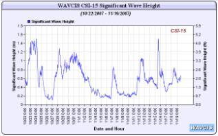
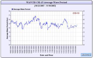
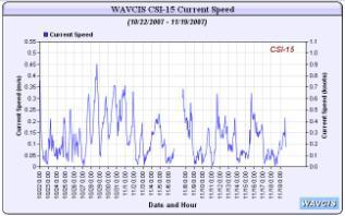
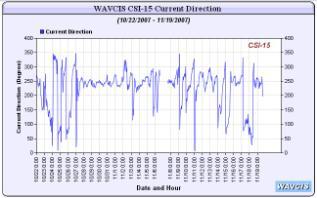
10 Real Time Data And Current Profiles provided on WAVCIS web pages Water Level in NAVD 88 Ocean Waves Workshop ( Proceedings (2011) / 103


11 Water Level in NAVD 88 Real-Time Directional Spectra and Spectral Evolution from the ADCP Wave directional plot Time series Ocean Waves Workshop ( Proceedings (2011) / 104


12 Past 24 Hour Data A way to view of short-term trends. Past 1 Month Data A way to view of long-term trends. Ocean Waves Workshop ( Proceedings (2011) / 105


13 NASA AERONET (Click to view real-time) Radiometer Data on 1/11/2011 Strong Inversion that weakens at about 2000 UTC Strong RH gradient near the top of the cloud layer Warm air aloft Cold air from north Increased levels of liquid water in the cloud layer Ocean Waves Workshop ( Proceedings (2011) / 106

14 Ceilometer Data on 1/11/2011 Cloud tops and mixing heights Cloud bases Mixing and cloud base heights increase in the afternoon as the temperature inversion weakens Sonic Anemometer A-C Bridge Data on 3/15/2011 Temperature Decrease Ocean Waves Workshop ( Proceedings (2011) / 107
 Ocean Waves Workshop (http://www.oceanwavesworkshop.uno.")
15 Sonic Anemometer A-C Bridge Data on 3/15/2011 Wind Shifts Numerical Modeling (NCEP/NOAA) (With area zoom capabilities and animation) Ocean Waves Workshop ( Proceedings (2011) / 108
 Ocean Waves Workshop (http://research.uno.")
16 Numerical Modeling (Mike 21) (With area zoom capabilities and animation) Numerical Modeling (SWAN/WW3) (SWAN nested in WW3, Louisiana coast only) Ocean Waves Workshop ( Proceedings (2011) / 109
 Ocean Waves Workshop (http://www.oceanwavesworkshop.uno.")
17 Numerical Modeling (SWAN) (With area zoom capabilities and animation) Numerical Modeling (WW3) (With area zoom capabilities and animation) Ocean Waves Workshop ( Proceedings (2011) / 110
 Other HYCOM products are")


18 Numerical Modeling (HYCOM) (With area zoom capabilities and animation) Other HYCOM products are water level, temperature and salinity. Model Validation (by clicking on WavCIS sites on the Louisiana coast map, to skill assess models) Ocean Waves Workshop ( Proceedings (2011) / 111

 Proceedings (2011) / 112")
19 Access to Archived Processed Data Access to Archived Processed Data Ocean Waves Workshop ( Proceedings (2011) / 112


20 Access to Archived Processed Data Summary WavCIS stations: maintained by CSI + FSG with a strong coastal dynamics, oceanographic, web technology and engineering expertise. It provides valuable info, esp. during the hurricane season. For near real-time model skill assessment of wind induced waves, hydrodynamics and wave models. WavCIS provides the data portal for the Hypoxia Program through LUMCON, NGOMEX/NOAA. Ocean Waves Workshop ( Proceedings (2011) / 113

21 Summary (Con t) NASA AERONET Program provides critical calibration data that is used to correct all satellite imagery and to better improve the infrared imagery products such as sea surface temperatures, chlorophyll, salinity, etc. The Sonoma Technology project - to provide better met info for use in improving predictions of the boundary layer parameters, improving regional-scale met. model predictions and providing a framework for advanced offshore measurements. Ocean Waves Workshop ( Proceedings (2011) / 114
Forecast of Nearshore Wave Parameters Using MIKE-21 Spectral Wave Model
 Forecast of Nearshore Wave Parameters Using MIKE-21 Spectral Wave Model Felix Jose 1 and Gregory W. Stone 2 1 Coastal Studies Institute, Louisiana State University, Baton Rouge, LA 70803 2 Coastal Studies
Todd Holland Naval Research Laboratory, Code , Building 1005, Stennis Space Center, MS 39529, USA
 A WAVCIS Based Ocean Observing Station to Provide Hydrodynamic Data off Eglin Air Force Base, Fort Walton, Florida, USA Gregory W. Stone Coastal Studies Institute and Department of Oceanography and Coastal
Module 11: Meteorology Topic 5 Content: Weather Maps Notes
 Introduction A variety of weather maps are produced by the National Weather Service and National Oceanographic Atmospheric Administration. These maps are used to help meteorologists accurately predict
HY-2A Satellite User s Guide
 National Satellite Ocean Application Service 2013-5-16 Document Change Record Revision Date Changed Pages/Paragraphs Edit Description i Contents 1 Introduction to HY-2 Satellite... 1 2 HY-2 satellite data
DBCP 2012 SCIENTIFIC AND TECHNICAL WORKSHOP Fremantle, Australia, 2 October 2012 SALIENT FEATURES OF INDIAN DEEP SEA INSTRUMENTED BUOY NETWORK IN THE
 DBCP 2012 SCIENTIFIC AND TECHNICAL WORKSHOP Fremantle, Australia, 2 October 2012 SALIENT FEATURES OF INDIAN DEEP SEA INSTRUMENTED BUOY NETWORK IN THE BAY OF BENGAL R. Venkatesan, Arul Muthiah, Simi Mathew
Session 3 Presentation - An Overview of Recent Wave Glider Field Program
 University of New Orleans ScholarWorks@UNO Ocean Waves Workshop Ocean Waves Workshop 2017 Dec 7th, 1:15 PM - 2:00 PM Session 3 Presentation - An Overview of Recent Wave Glider Field Program Pat Fitzpatrick
an accessible interface to marine environmental data Russell Moffitt
 an accessible interface to marine environmental data Russell Moffitt The Atlas Project GOAL: To provide a single point of access to oceanographic and environmental data for use by marine resource researchers,
Observing System Requirements for the Harmful Algal Bloom Forecast System in the Gulf of Mexico
 Observing System Requirements for the Harmful Algal Bloom Forecast System in the Gulf of Mexico July 2007 Background The Harmful Algal Bloom (HAB) Forecast System provides nowcasts and forecasts of Karenia
Add NOAA nowcoast Layers to Maps
 WebEOC Maps Add-on Quick Reference Guide Add NOAA nowcoast Layers to Maps Overview With Maps Add-on, you can configure an unlimited number of map layers. These layers allow you to control the data you
Observational Needs for Polar Atmospheric Science
 Observational Needs for Polar Atmospheric Science John J. Cassano University of Colorado with contributions from: Ed Eloranta, Matthew Lazzara, Julien Nicolas, Ola Persson, Matthew Shupe, and Von Walden
J2.11 ANALYSIS OF THREE YEARS OF BOUNDARY LAYER OBSERVATIONS OVER THE GULF OF MEXICO AND ITS SHORES
 J2.11 ANALYSIS OF THREE YEARS OF BOUNDARY LAYER OBSERVATIONS OVER THE GULF OF MEXICO AND ITS SHORES 1. INTRODUCTION Steven R. Hanna* Hanna Consultants, Kennebunkport, Maine Clinton P. MacDonald, Mark A.
Analysis of Near-Surface Oceanic Measurements Obtained During CBLAST-Low
 Analysis of Near-Surface Oceanic Measurements Obtained During CBLAST-Low John H. Trowbridge Woods Hole Oceanographic Institution, MS#12, Woods Hole, MA 02543 phone: (508) 289-2296 fax: (508) 457-2194 email:
Spectral Wave Transformation over an Elongated Sand Shoal off South-Central Louisiana, U.S.A.
 Journal of Coastal Research SI 50 757-761 ICS2007 (Proceedings) Australia ISSN 0749.0208 Spectral Wave Transformation over an Elongated Sand Shoal off South-Central Louisiana, U.S.A. F. Jose, D. Kobashi
Lectures 7 and 8: 14, 16 Oct Sea Surface Temperature
 Lectures 7 and 8: 14, 16 Oct 2008 Sea Surface Temperature References: Martin, S., 2004, An Introduction to Ocean Remote Sensing, Cambridge University Press, 454 pp. Chapter 7. Robinson, I. S., 2004, Measuring
HFR Surface Currents Observing System in Lower Chesapeake Bay and Virginia Coast
 HFR Surface Currents Observing System in Lower Chesapeake Bay and Virginia Coast Larry P. Atkinson, Teresa Garner, and Jose Blanco Center for Coastal Physical Oceanography Old Dominion University Norfolk,
Studying the Ocean Using Live Data
 Studying the Ocean Using Live Data Overview The Argo buoy project is a major oceanographic study that harnesses the power of automated unmanned buoys traveling the world s oceans (http://www.argo.ucsd.edu/).
Environmental Data In Support of Search & Rescue Operations in the Central Mediterranean Sea
 Environmental Data In Support of Search & Rescue Operations in the Central Mediterranean Sea Dr. Eric Comerma (RPS ASA) eric.comerma@rpsgroup.com Cathleen Turner (RPS ASA) Prof. Aldo Drago (Univ. of Malta)
Earth Observation in coastal zone MetOcean design criteria
 ESA Oil & Gas Workshop 2010 Earth Observation in coastal zone MetOcean design criteria Cees de Valk BMT ARGOSS Wind, wave and current design criteria geophysical process uncertainty modelling assumptions
Development and deployment plan of ARGO type buoy in the Arctic Ocean
 1/16 Development and deployment plan of ARGO type buoy in the Arctic Ocean by T.Kikuchi, N.Shikama (JAMSTEC), D.Langevin, T.Monk, and O.Lebreton (MetOcean) 2/16 Ice-drifting buoy observation J-CAD ( JAMSTEC
Current Application of Vicarious Calibration for Geostationary Ocean Color Imager (GOCI) DATA
 DATA") Current Application of Vicarious Calibration for Geostationary Ocean Color Imager (GOCI) DATA On behalf of Jae-Hyun Ahn & Young-je Park, Seongick CHO(Secondment at Astrium SAS, France) Korea Ocean Satellite
Current Application of Vicarious Calibration for Geostationary Ocean Color Imager (GOCI) DATA On behalf of Jae-Hyun Ahn & Young-je Park, Seongick CHO(Secondment at Astrium SAS, France) Korea Ocean Satellite
How Warm Is the Ocean?
 Currents and Sea Surface Temperature By Steven Moore, Jennifer Vuturo-Brady, and Hedley Bond Guiding Question Learning Objectives How do ocean currents impact seasonal sea surface temperatures? Students
Trevor Lee Director, Buildings. Grant Edwards PhD Department of Environment and Geography
 Weather Affects Building Performance Simulation v Monitoring real time solar and coincident weather data for building optimisation and energy management Trevor Lee Director, Buildings Grant Edwards PhD
How typical are current conditions?
 How typical are current conditions? NANOOS provides many sources of information for those wanting to track oceanographic conditions throughout the NE Pacific Ocean to be able to understand if the current
Overview of the Tropical Cyclone Guidance Project
 Overview of the Tropical Cyclone Guidance Project Dr. Jonathan L. Vigh With thanks to Mahsa Mirzargar (Univ. of Miami) Shanghai Typhoon Institute 09 July 2018 NCAR is sponsored by the National Science
Long Term Autonomous Ocean Remote Sensing Utilizing the Wave Glider
 Long Term Autonomous Ocean Remote Sensing Utilizing the Wave Glider J. Griffith, K. VanderLugt, Matt Cosad Liquid Robotics 1329 Moffett Park Drive Sunnyvale, CA 94089 Abstract Rising costs of ship time
METOC at Defence Center for Operational Oceanography (FCOO)
") METOC at Defence Center for Operational Oceanography (FCOO) Forsvarets Center for Operativ Oceanografi Dr. Johan Söderqvist Oceanographer jos@fcoo.dk FCOO Staff (13 pos.) Geophysical expertise: oceanography,
METOC at Defence Center for Operational Oceanography (FCOO) Forsvarets Center for Operativ Oceanografi Dr. Johan Söderqvist Oceanographer jos@fcoo.dk FCOO Staff (13 pos.) Geophysical expertise: oceanography,
Satellite Remote Sensing for Ocean
 Satellite Remote Sensing for Ocean August 17, 2017 Masatoshi Kamei RESTEC All rights reserved RESTEC 2015 Contents 1. About RESTEC and Remote Sensing 2. Example of Remote Sensing Technology 3. Remote Sensing
Monitoring Sea Surface temperature change at the Caribbean Sea, using AVHRR images. Y. Santiago Pérez, and R. Mendez Yulfo
 Monitoring Sea Surface temperature change at the Caribbean Sea, using AVHRR images. Y. Santiago Pérez, and R. Mendez Yulfo Department of Geology, University of Puerto Rico Mayagüez Campus, P.O. Box 9017,
Pioneer Array. MAB continental shelf and slope. Context: Array design:
 Pioneer Array MAB continental shelf and slope Context: Fresh water to the north drives along-shelf flow Persistent front at ~150 m isobath Complex slope sea influenced by Gulf Stream eddies and meanders
IMPACT OF GROUND-BASED GPS PRECIPITABLE WATER VAPOR AND COSMIC GPS REFRACTIVITY PROFILE ON HURRICANE DEAN FORECAST. (a) (b) (c)
 (b) (c)") 9B.3 IMPACT OF GROUND-BASED GPS PRECIPITABLE WATER VAPOR AND COSMIC GPS REFRACTIVITY PROFILE ON HURRICANE DEAN FORECAST Tetsuya Iwabuchi *, J. J. Braun, and T. Van Hove UCAR, Boulder, Colorado 1. INTRODUCTION
9B.3 IMPACT OF GROUND-BASED GPS PRECIPITABLE WATER VAPOR AND COSMIC GPS REFRACTIVITY PROFILE ON HURRICANE DEAN FORECAST Tetsuya Iwabuchi *, J. J. Braun, and T. Van Hove UCAR, Boulder, Colorado 1. INTRODUCTION
Can buoys predict hurricanes? Objectives Students will be able to: track drifter buoys determine the course of the gulf stream current
 Drifters Can buoys predict hurricanes? Objectives Students will be able to: track drifter buoys determine the course of the gulf stream current Materials computers with Internet access Student Worksheet
Interpretation of Polar-orbiting Satellite Observations. Atmospheric Instrumentation
 Interpretation of Polar-orbiting Satellite Observations Outline Polar-Orbiting Observations: Review of Polar-Orbiting Satellite Systems Overview of Currently Active Satellites / Sensors Overview of Sensor
TAMSAT: LONG-TERM RAINFALL MONITORING ACROSS AFRICA
 TAMSAT: LONG-TERM RAINFALL MONITORING ACROSS AFRICA Ross Maidment, Emily Black, Matthew Young and Dagmawi Asfaw TAMSAT, University of Reading Helen Greatrex IRI, Columbia University 13 th EUMETSAT User
How ECMWF has addressed requests from the data users
 How ECMWF has addressed requests from the data users David Richardson Head of Evaluation Section, Forecast Department, ECMWF David.richardson@ecmwf.int ECMWF June 14, 2017 Overview Review the efforts made
Coastal Emergency Risks Assessment - CERA Real-Time Storm Surge and Wave Visualization Tool
 Coastal Emergency Risks Assessment - CERA Real-Time Storm Surge and Wave Visualization Tool Introduction This document provides guidance for using the Coastal Emergency Risks Assessment (CERA) visualization
CONTENT 2. ORGANIZATION 3. SERVICES. instruments. (3)Activities of RIC Tsukuba
Activities of RIC Tsukuba") 1 CONTENT 1. INTRODUCTION 2. ORGANIZATION 3. SERVICES (1)Quality assurance of meteorological instruments (2)Research and development (3)Activities of RIC Tsukuba 2 Meteorological Instruments Center (MIC)
1 CONTENT 1. INTRODUCTION 2. ORGANIZATION 3. SERVICES (1)Quality assurance of meteorological instruments (2)Research and development (3)Activities of RIC Tsukuba 2 Meteorological Instruments Center (MIC)
CHAPTER 13 WEATHER ANALYSIS AND FORECASTING MULTIPLE CHOICE QUESTIONS
 CHAPTER 13 WEATHER ANALYSIS AND FORECASTING MULTIPLE CHOICE QUESTIONS 1. The atmosphere is a continuous fluid that envelops the globe, so that weather observation, analysis, and forecasting require international
Hindcast Arabian Gulf
 Hindcast Arabian Gulf Image of isobars of atmospheric pressure and hindcast wind- and wave field over the Arabian Gulf during a storm in January 1993. Detailed wave studies are supported by nesting of
Homework 2: Hurricane Katrina. Part 1. Hurricane Katrina, August 28, 2005 Satellite Imagery
 Metr 302 Homework 2 Fall 2014 Meteorology 302 Fall 2014 Name Homework 2: Hurricane Katrina 100 points total Distributed Thursday 30 October 2014; Due Thursday 13 November 2014 Answer all questions in complete
National Ocean Technology Center of China Wang Xiangnan
 National Ocean Technology Center of China Wang Xiangnan 2011.10 1 National Ocean Technology Center Beijing Tianjin NOTC Established in 1965 Staff of 500 Bohai Sea 2 3 National Ocean Technology Center Administrated
25.1 Air Masses. Section 25.1 Objectives
 Section 25.1 Objectives Explain how an air mass forms. List the four main types of air masses. Describe how air masses affect the weather of North America. Air Masses 25.1 Air Masses Differences in air
May 17, earthsciencechapter24.notebook. Apr 8 10:54 AM Review. Grade:9th. Subject:Earth Science. Date:4/8.
 Apr 8 10:54 AM 24.1 Review Grade:9th Subject:Earth Science Date:4/8 Apr 8 9:29 AM 1 1 As lower layers of air are warmed... A the air rises B winds form C the air dries D the air sinks Apr 8 9:49 AM 2 What
Session 1 Presentation - Use of Offshore Energy Facilities as Deepwater Ocean Observing Platforms
 University of New Orleans ScholarWorks@UNO Ocean Waves Workshop Ocean Waves Workshop 2017 Dec 7th, 9:00 AM - 9:45 AM Session 1 Presentation - Use of Offshore Energy Facilities as Deepwater Ocean Observing
The Field Research Facility, Duck, NC Warming Ocean Observations and Forecast of Effects
 The Field Research Facility, Duck, NC Warming Ocean Observations and Forecast of Effects A potential consequence of a warming ocean is more frequent and more intense wind events (Hurricanes & Typhoons)
A Ngari Director Cook Islands Meteorological Service
 WORLD METEOROLOGICAL ORGANIZATION REGIONAL SEMINAR ON CLIMATE SERVICES IN REGIONAL ASSOCIATION V (SOUTH-WEST PACIFIC) Honiara, Solomon Islands, 1-4 November 2011 A Ngari Director Cook Islands Meteorological
Coupling of Waves, Turbulence and Thermodynamics across the Marginal Ice Zone
 DISTRIBUTION STATEMENT A. Approved for public release; distribution is unlimited. Coupling of Waves, Turbulence and Thermodynamics across the Marginal Ice Zone Tim Stanton and Bill Shaw Oceanography Department,
C M E M S O c e a n C o l o u r S a t e l l i t e P r o d u c t s
 Implemented by C M E M S O c e a n C o l o u r S a t e l l i t e P r o d u c t s This slideshow gives an overview of the CMEMS Ocean Colour Satellite Products Marine LEVEL1 For Beginners- Slides have been
SAWS: Met-Ocean Data & Infrastructure in Support of Industry, Research & Public Good. South Africa-Norway Science Week, 2016
 SAWS: Met-Ocean Data & Infrastructure in Support of Industry, Research & Public Good South Africa-Norway Science Week, 2016 Marc de Vos, November 2016 South Africa: Context http://learn.mindset.co.za/sites/default/files/resourcelib/e
Government of Sultanate of Oman Public Authority of Civil Aviation Directorate General of Meteorology. National Report To
 Government of Sultanate of Oman Public Authority of Civil Aviation Directorate General of Meteorology National Report To Panel on Tropical Cyclones in the Bay of Bengal And Arabian Sea 43rd Session, India
COVERAGE-Sargasso Sea
 COVERAGE-Sargasso Sea A Collaborative Project between NASA and the Sargasso Sea Commission Dr. Vardis Tsontos Dr. Jorge Vazquez NASA Jet Propulsion Laboratory, California Institute of Technology UN-HQ
Ocean-Atmosphere Fluxes & Marine Meteorology
 Ocean-Atmosphere Fluxes & Marine Meteorology Breakout Group Questions How can the CND be enhanced to better address this science theme? What other approaches could be combined with the observatory elements
Darren Wright Maritime Services Program Manager Center for Operational Oceanographic Products and Services (CO-OPS)
") Darren Wright Maritime Services Program Manager Center for Operational Oceanographic Products and Services (CO-OPS) Center for Operational Oceanographic Products and Services (CO-OPS) National Water Level
Darren Wright Maritime Services Program Manager Center for Operational Oceanographic Products and Services (CO-OPS) Center for Operational Oceanographic Products and Services (CO-OPS) National Water Level
A Review of the 2014 Gulf of Mexico Wave Glider Field Program
 A Review of the 2014 Gulf of Mexico Wave Glider Field Program Pat Fitzpatrick, Yee Lau, Robert Moorhead, Adam Skarke Mississippi State University Daniel Merritt, Keith Kreider, Chris Brown, Ryan Carlon,
The MSC Beaufort Wind and Wave Reanalysis
 The MSC Beaufort Wind and Wave Reanalysis Val Swail Environment Canada Vincent Cardone, Brian Callahan, Mike Ferguson, Dan Gummer and Andrew Cox Oceanweather Inc. Cos Cob, CT, USA Introduction: History
The ITSU System in the Pacific Region and Future Upgrades
 The ITSU System in the Pacific Region and Future Upgrades Eddie Bernard Director, Pacific Marine Environmental Laboratory (PMEL) NOAA/USA Pacific Tsunami Warning Center OPERATIONAL ACTIVITIES SEISMIC DATA
T-PARC and TCS08 (Submitted by Pat Harr, Russell Elsberry and Tetsuo Nakazawa)
") WORLD METEOROLOGICAL ORGANIZATION COMMISSION FOR ATMOSPHERIC SCIENCES INTERNATIONAL CORE STEERING COMMITTEE FOR THORPEX Eighth Session DWD, Offenbach (2 4 November 2009) CAS/ICSC-8/DOC4.1 (3 X.2009) Item:
WORLD METEOROLOGICAL ORGANIZATION COMMISSION FOR ATMOSPHERIC SCIENCES INTERNATIONAL CORE STEERING COMMITTEE FOR THORPEX Eighth Session DWD, Offenbach (2 4 November 2009) CAS/ICSC-8/DOC4.1 (3 X.2009) Item:
Wind Tower Deployments and Pressure Sensor Installation on Coastal Houses Preliminary Data Summary _ Sea Grant Project No.
 Wind Tower Deployments and Pressure Sensor Installation on Coastal Houses Preliminary Data Summary _ Sea Grant Project No.:1020040317 Submitted to: South Carolina Sea Grant Consortium 287 Meeting Street
Texas Coastal Ocean Observation Network. Richard Edwing Director, Center for Operational Oceanographic Products and Services November 2016
 Texas Coastal Ocean Observation Network Richard Edwing Director, Center for Operational Oceanographic Products and Services November 2016 What is CO-OPS? Meaningful oceanographic data for the Nation CO-OPS
Vertical structure and precipitation properties in typhoon rainbands
 The 4 th THORPEX-Asia Science workshop, Kunming, China on 31 Oct.-2 Nov. 2012 Vertical structure and precipitation properties in typhoon rainbands Dong-Kyun Kim, Yeon-Hee Kim, Kwan-Young Chung Forecast
Abstract. Introduction
 Advanced Microwave System For Measurement of ABL Thermal Stratification in Polar Region V.V. Folomeev*, E.N. Kadygrov*, E.A. Miller*, V.V. Nekrasov*, A.N. Shaposhnikov*, A.V. Troisky** * Central aerological
Satellite-based Red-Tide Detection/Monitoring
 Satellite-based Detection/Monitoring Contents 1. Introduction - and Its Monitoring System 2. Detection Using Ocean Color Remote Sensing 3. Satellite-Based Monitoring in the Asian Coastal Seas Hiroshi KAWAMURA
Climate & Earth System Science. Introduction to Meteorology & Climate. Chapter 05 SOME OBSERVING INSTRUMENTS. Instrument Enclosure.
 Climate & Earth System Science Introduction to Meteorology & Climate MAPH 10050 Peter Lynch Peter Lynch Meteorology & Climate Centre School of Mathematical Sciences University College Dublin Meteorology
P1.16 RECENT MONITORING OF SUSPENDED SEDIMENT PATTERNS ALONG LOUISIANA S COASTAL ZONE USING ER-2 BASED MAS DATA AND TERRA BASED MODIS DATA.
 P1.16 RECENT MONITORING OF SUSPENDED SEDIMENT PATTERNS ALONG LOUISIANA S COASTAL ZONE USING ER-2 BASED MAS DATA AND TERRA BASED MODIS DATA. Christopher C. Moeller* 1, M. M. Gunshor 1, W. P. Menzel 2, O.K.
Harmful Algal Bloom Detectives in the Gulf of Mexico Satellites, Gliders and Buoys, Oh My!
 Harmful Algal Bloom Detectives in the Gulf of Mexico Satellites, Gliders and Buoys, Oh My! By Chris Simoniello and Ruth Mullins* With information from: *The Gulf of Mexico Coastal Ocean Observing System
Visibility in Low Clouds And Its Impact on FSO Links
 Visibility in Low Clouds And Its Impact on FSO Links M. Ammar Al-Habash, Janae Nash, Jeff Baars, Michael Witiw, Ken Fischer, Ken Desmet Terabeam Corporation, 14833 NE 87th St., Building C, Redmond, WA
VAISALA GLOBAL LIGHTNING DATASET GLD360
 VAISALA GLOBAL LIGHTNING DATASET GLD360 Technology, operations, and applications overview JULY 2009 MIke Grogan Application Services Manager Observation Services Nick Demetriades Applications Manager,
Updates on CMA FENGYUN Meteorological Satellite Programs
 Updates on CMA FENGYUN Meteorological Satellite Programs Peng ZHANG National Satellite Meteorological Center, China Meteorological Administration (NSMC/CMA) 29 Nov. - 5 Dec. 2017, Darmstadt, Germany 1.
Table-Top Exercise for Emergency Preparedness Evaluation: Little Anse, Isle Madame
 Table-Top Exercise for Emergency Preparedness Evaluation: Little Anse, Isle Madame Alexander Chung, M.Sc. Candidate C-Change Student Research Associate May 2013 The Community of Little Anse Coastal community
Exploitation of Ocean Predictions by the Oil and Gas Industry. GODAE OceanView Symposium 2013
 Exploitation of Ocean Predictions by the Oil and Gas Industry GODAE OceanView Symposium 2013 Introduction Information needs Challenges Acknowledgements IMarEST/SUT Metocean Awareness Course Colleagues
Urgent Computing for Hurricane Forecasts
 Urgent Computing for Hurricane Forecasts Gabrielle Allen Center for Computation & Technology Dept Computer Science Louisiana State University gallen@cct.lsu.edu Representing the SURA Coastal Ocean Observing
Met Office and UK University contribution to YMC Ground instrumentation and modelling
 Met Office and UK University contribution to YMC Ground instrumentation and modelling Cathryn Birch 1,2 Adrian Matthews 3, Steve Woolnough 4, John Marsham 2, Douglas Parker 2, Paul Barret 1, Prince Xavier
RAV VLab Report Australian VLab Centre of Excellence
 RAV VLab Report Australian VLab Centre of Excellence VLMG-7 Meeting St. Petersburg, 21 25 July 2014 Bodo Zeschke Australian VLab Centre of Excellence Point of Contact Overview of Australian VLab Centre
APPENDIX 2 OVERVIEW OF THE GLOBAL PRECIPITATION MEASUREMENT (GPM) AND THE TROPICAL RAINFALL MEASURING MISSION (TRMM) 2-1
 AND THE TROPICAL RAINFALL MEASURING MISSION (TRMM) 2-1") APPENDIX 2 OVERVIEW OF THE GLOBAL PRECIPITATION MEASUREMENT (GPM) AND THE TROPICAL RAINFALL MEASURING MISSION (TRMM) 2-1 1. Introduction Precipitation is one of most important environmental parameters.
APPENDIX 2 OVERVIEW OF THE GLOBAL PRECIPITATION MEASUREMENT (GPM) AND THE TROPICAL RAINFALL MEASURING MISSION (TRMM) 2-1 1. Introduction Precipitation is one of most important environmental parameters.
SYNERGY OF SATELLITE REMOTE SENSING AND SENSOR NETWORKS ON GEO GRID
 SYNERGY OF SATELLITE REMOTE SENSING AND SENSOR NETWORKS ON GEO GRID National Institute of Advanced Industrial Science and Technology, Japan Yoshio Tanaka (on behalf of AIST GEO Grid team) Contents Brief
FOWPI Metocean Workshop Modelling, Design Parameters and Weather Windows
 FOWPI Metocean Workshop Modelling, Design Parameters and Weather Windows Jesper Skourup, Chief Specialist, COWI 1 The Project is funded by The European Union Agenda 1. Metocean Data Requirements 2. Site
LOG_aLevel. Tsunami Warning System
 LOG_aLevel Tsunami Warning System General Acoustics e.k. Am Kiel-Kanal 1 24106 Kiel Germany Phone: +49 431 5 80 81 80 www.generalacoustics.com Info@generalacoustics.com LOG_aLevel Tsunami Warning System
FINO Technical and Environmental Research Platforms for the Benefit of the Offshore Industry
 FINO Technical and Environmental Research Platforms for the Benefit of the Offshore Industry Andreas Beeken & Detlef Kindler, 2011-09-07 BALTEXPO, Gdansk 2011 Project Overview FINO Forschung in Nord- und
Ocean currents from altimetry
 Ocean currents from altimetry Pierre-Yves LE TRAON - CLS - Space Oceanography Division Gamble Workshop - Stavanger,, May 2003 Introduction Today: information mainly comes from in situ measurements ocean
Atmosphere-Ocean Interaction in Tropical Cyclones
 Atmosphere-Ocean Interaction in Tropical Cyclones Isaac Ginis University of Rhode Island Collaborators: T. Hara, Y.Fan, I-J Moon, R. Yablonsky. ECMWF, November 10-12, 12, 2008 Air-Sea Interaction in Tropical
: : User Manual: : - 10 December
 : : User Manual: : - 0 December 06 - : : User Manual: : Table of Contents. Map Control. How to move a map. How to zoom in and out a map 4. How to inquire Ocean Currents. How to inquire predicted current
SPATIAL CHARACTERISTICS OF THE SURFACE CIRCULATION AND WAVE CLIMATE USING HIGH-FREQUENCY RADAR
 SPATIAL CHARACTERISTICS OF THE SURFACE CIRCULATION AND WAVE CLIMATE USING HIGH-FREQUENCY RADAR Apisit Kongprom,Siriluk Prukpitikul, Varatip Buakaew, Watchara Kesdech, and Teerawat Suwanlertcharoen Geo-Informatics
Texas Automated Buoy System (TABS)
") Texas Automated Buoy System (TABS) Ocean Science, Technology and Operations Workforce Workshop November 10-12, 2008 Norman L. Guinasso Jr., John N. Walpert, Leslie C. Bender Geochemical and Environmental
Texas Automated Buoy System (TABS) Ocean Science, Technology and Operations Workforce Workshop November 10-12, 2008 Norman L. Guinasso Jr., John N. Walpert, Leslie C. Bender Geochemical and Environmental
Sediment Flux and Trapping on the Skagit Tidal Flats
 Sediment Flux and Trapping on the Skagit Tidal Flats W. Rockwell Geyer Woods Hole Oceanographic Institution MS 11, Woods Hole, MA 02543 phone: 508-289-2868 fax: 508-457-2194 email: rgeyer@whoi.edu Peter
Complex Terrain (EDUCT) experiment, conducted by the National Center for Atmospheric
 experiment, conducted by the National Center for Atmospheric") Alex Ameen Shenandoah Trip Paper I visited Shenandoah National Park on April 11, 2009 to investigate the Education in Complex Terrain (EDUCT) experiment, conducted by the National Center for Atmospheric
Alex Ameen Shenandoah Trip Paper I visited Shenandoah National Park on April 11, 2009 to investigate the Education in Complex Terrain (EDUCT) experiment, conducted by the National Center for Atmospheric
Improved Fields of Satellite-Derived Ocean Surface Turbulent Fluxes of Energy and Moisture
 Improved Fields of Satellite-Derived Ocean Surface Turbulent Fluxes of Energy and Moisture First year report on NASA grant NNX09AJ49G PI: Mark A. Bourassa Co-Is: Carol Anne Clayson, Shawn Smith, and Gary
2) What general circulation wind belt is the place of origin for hurricanes? A) westerlies B) trade winds C) doldrums D) horse latitudes
 What general circulation wind belt is the place of origin for hurricanes? A) westerlies B) trade winds C) doldrums D) horse latitudes") Meteo 1010 Homework 6 1) What is the difference between a typhoon and a hurricane? A) A hurricane is a true tropical cyclone, but a typhoon is not. B) A hurricane is stronger than a typhoon. C) They represent
Meteo 1010 Homework 6 1) What is the difference between a typhoon and a hurricane? A) A hurricane is a true tropical cyclone, but a typhoon is not. B) A hurricane is stronger than a typhoon. C) They represent
Forecast Predictions of Winds, Waves and Storm Surge during Hurricane Arthur (2014)
") Forecast Predictions of Winds, Waves and Storm Surge during Hurricane Arthur (2014) R Cyriac 1, JC Dietrich 1, JG Fleming 2, BO Blanton 3, RA Luettich Jr 4, C Kaiser 5 1 Dept. of Civil, Construction, and
Forecast Predictions of Winds, Waves and Storm Surge during Hurricane Arthur (2014) R Cyriac 1, JC Dietrich 1, JG Fleming 2, BO Blanton 3, RA Luettich Jr 4, C Kaiser 5 1 Dept. of Civil, Construction, and
"Outcomes of the storm surge and waves workshop in Dominican Republic and the questionnaire"
 "Outcomes of the storm surge and waves workshop in Dominican Republic and the questionnaire" Strengthening Regional Cooperation to Support Forecasting with Multi Hazard Approach in RA IV Ritz Carlton Grand
Sharks and Tropical Weather
 Target Audience: Middle - High School (8-12) Sharks and Tropical Weather Resources: Research data based on Running before the Storm: blacktip sharks respond to falling barometric pressure associated with
Development of Innovative Technology to Provide Low-Cost Surface Atmospheric Observations in Data-sparse Regions
 Development of Innovative Technology to Provide Low-Cost Surface Atmospheric Observations in Data-sparse Regions Paul Kucera and Martin Steinson University Corporation for Atmospheric Research/COMET 3D-Printed
Moisture, Clouds, and Precipitation: Clouds and Precipitation. Dr. Michael J Passow
 Moisture, Clouds, and Precipitation: Clouds and Precipitation Dr. Michael J Passow What Processes Lift Air? Clouds require three things: water vapor, a condensation nucleus, and cooling Cooling usually
Chapter Introduction. Weather. Patterns. Forecasts Chapter Wrap-Up
 Chapter Introduction Lesson 1 Lesson 2 Lesson 3 Describing Weather Weather Patterns Weather Forecasts Chapter Wrap-Up How do scientists describe and predict weather? What do you think? Before you begin,
The MedArgo program and SMOS validation in the Mediterranean Sea
 The MedArgo program and SMOS validation in the Mediterranean Sea by Pierre-Marie Poulain (OGS, Trieste) Jordi Font (ICM, Barcelona) Srdjan Dobricic (INGV, Bologna) The Mediterranean Operational Oceanography
MOUNTAIN TERRAIN ATMOSPHERIC MODELING AND OBSERVATIONS (MATERHORN) PROGRAM
 PROGRAM") MOUNTAIN TERRAIN ATMOSPHERIC MODELING AND OBSERVATIONS (MATERHORN) PROGRAM by H.J.S. Fernando Environmental Fluid Dynamics Laboratories Department of Civil Engineering & Geological Sciences and Aerospace
MOUNTAIN TERRAIN ATMOSPHERIC MODELING AND OBSERVATIONS (MATERHORN) PROGRAM by H.J.S. Fernando Environmental Fluid Dynamics Laboratories Department of Civil Engineering & Geological Sciences and Aerospace
Performance of the Nortek Aquadopp Z-Cell Profiler on a NOAA Surface Buoy
 Performance of the Nortek Aquadopp Z-Cell Profiler on a NOAA Surface Buoy Eric Siegel NortekUSA Annapolis, USA Rodney Riley & Karen Grissom NOAA National Data Buoy Center Stennis Space Center, USA Abstract-Observations
11/19/14. Chapter 11: Hurricanes. The Atmosphere: An Introduction to Meteorology, 12 th. Lutgens Tarbuck
 Chapter 11: Hurricanes The Atmosphere: An Introduction to Meteorology, 12 th Lutgens Tarbuck Lectures by: Heather Gallacher, Cleveland State University! Hurricanes: " Hurricanes are intense centers of
South Bay Coastal Ocean Observing System California Clean Beaches Initiative
 South Bay Coastal Ocean Observing System California Clean Beaches Initiative Second Quarterly Report January, 2003 to City of Imperial Beach Eric Terrill 1 1 Scripps Institution of Oceanography, University
Near surface temperature sampling from Apex floats
 Near surface temperature sampling from Apex floats AST-12, March 2011 Jon Turton, UK Met Office Diurnal variation of SST The Argo array of profiling floats provides profiles of temperature and salinity
The Physical Context for Thin Layers in the Coastal Ocean
 The Physical Context for Thin Layers in the Coastal Ocean David M. Fratantoni Physical Oceanography Department Woods Hole Oceanographic Institution Woods Hole, MA 02543 phone: (508) 289-2908 fax: (508)
J2.6 SONAR MEASUREMENTS IN THE GULF STREAM FRONT ON THE SOUTHEAST FLORIDA SHELF COORDINATED WITH TERRASAR-X SATELLITE OVERPASSES
 J2.6 SONAR MEASUREMENTS IN THE GULF STREAM FRONT ON THE SOUTHEAST FLORIDA SHELF COORDINATED WITH TERRASAR-X SATELLITE OVERPASSES Chris Maingot 1, Alexander Soloviev 1, Silvia Matt 1, Mikhail Gilman 1,