Towards Operational Coastal Modelling in Australia and New Zealand Presentation Title, Arial Regular 29pt Sub title, Arial Regular 24pt
|
|
|
- Linda Robbins
- 5 years ago
- Views:
Transcription
1 Towards Operational Coastal Modelling in Australia and New Zealand Presentation Title, Arial Regular 29pt Sub title, Arial Regular 24pt Philip Gillibrand & Mike Herzfeld CSIRO Marine & Atmospheric Research, Hobart Charitha Pattiaratchi University of Western Australia, Crawley Graham Rickard, Stephane Popinet NIWA, Greta Point, Wellington Emily Lane NIWA, Riccarton, Christchurch
2 Acknowledgements CSIRO Environmental Modelling Group: John Parslow, Mike Herzfeld, Karen Wild-Allen, Nugzar Margvelashvili, Farhan Rizwi, John Andrewartha, Emlyn Jones, Jenny Skerratt, Mathieu Mongin NIWA: Rob Bell, Michael Uddstrom
3 Outline Near Real-time (NRT) modelling in Australia Rationale Methods Some example of regional studies Data assimilation The Ribbon model Hindcast modelling in Western Australia Operational Coastal Ocean Modelling in NZ EcoConnect Storm surge forecasting Shared Aspirations and Potential Cooperation


4 Coastal Ocean Observatories Development of coastal observatories Observation networks + operational modelling
5 Near Real-time (NRT) Modelling: Rationale Previous approach: Nominate a hindcast period (usually 1 year) and produce a calibrated model for that period. Problems: Model loses relevance as time goes by. Model is put on the shelf at the project s termination and inaccessible to stakeholders. Difficult to resurrect models as code base evolves. Producing a new hindcast involves considerable effort. NRT approach: Provides a potentially indefinite archive of results long term results may potentially be accumulated. Always remains relevant. May be used to re-run hindcast scenarios for any period it is running (fast models). May run BGC/sediment scenarios for any period within the archive using transport models (slow models). Can use higher resolution since runtime need only be ~2:1. Usually easier to implement since near real-time forcing products are readily available over the web.
6 NRT approach Bathymetry derived from high resolution databases e.g. Geoscience Australia 250 m product Downscale from operational global ocean products Often several nests are required. Supply initial and open boundary conditions (T/S, η, v). Open boundary configuration is critical. Often tidal effects are superimposed. Operational atmospheric models supply surface boundary conditions. Momentum wind stress. Heat flux: Can apply components directly (no feedback). Compute components using bulk schemes, with feedback. Freshwater flux.
.")

7 Ocean and Atmospheric Models Ocean Bluelink project (BoM, CSIRO). OceanMAPS operational product. BRAN data assimilating hindcasts. Global ocean model based on mom4p1 codebase. 10 km resolution in Australasian region. Provides daily means of temperature, salinity, sea level and velocity. Does not include tides, atmospheric pressure or freshwater river input (in Australia). BRAN 3.0 SST and currents in NE Australia Atmosphere ACCESS-A meteorological product, Operationally run by BoM ~12 km resolution. Use surface fields of: Wind stress for momentum boundary condition. Cloud to compute short wave radiation. Pressure, dry & dew point temperature to compute bulk fluxes and longwave radiation. Precipitation for freshwater fluxes. ACCESS 10m winds, reproduced from:
 Advection schemes Turbulence")
8 Sparse Hydrodynamic Ocean Code (SHOC) General hydrodynamic coastal ocean model Uses a sparse indexing system for memory efficiency Solves 2D or 3D hydrostatic Reynolds-averaged Navier- Stokes equations using finite differences Multiple options available: Rectilinear, curvilinear, polar etc staggered grid Vertical discretization (z-level or sigma-coords) Advection schemes Turbulence closure schemes Open boundary conditions Momentum, heat, freshwater bulk schemes Horizontal mixing (fixed or Smagorinsky) Bottom friction (linear or nonlinear) Integrated into the Environmental Modelling Suite, a coupled hydrodynamic-sediment transportbiogeochemistry modelling system.

9 Multiple nested downscaling A boundary cell ratio of 7:1 is considered the upper bound. Multiple nests may be required to conform to this criterion.

10 Examples: Routine NRT results can be viewed at: e.g. for Storm Bay, D Entrecasteaux, Huon, Derwent South East Queensland GBR Near real-time implementations
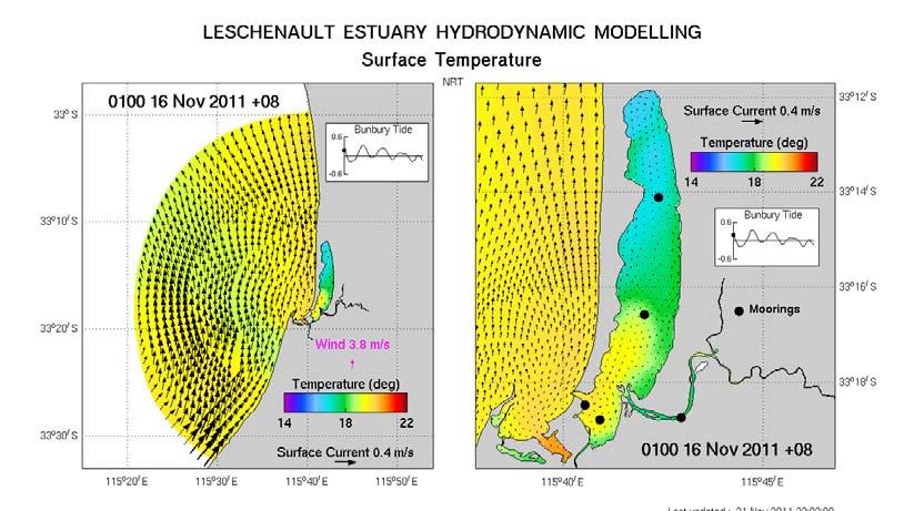
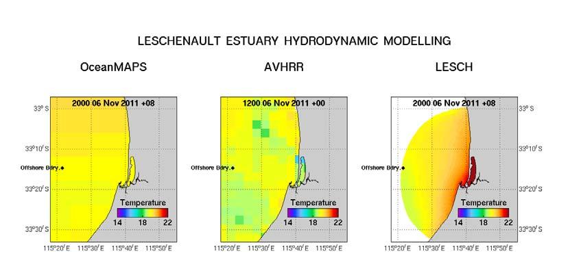


11 Leschenault Estuary, W.A. OceanMAPS AVHRR TRIKE
 32 30 28 26 Observed and")


12 Hindcast heuristic calibration example : GBR 36 Moorings 34 Salinity (PSU) Observed and modelled salinity at Yongala National reference station. GBR - surface GBR - 10m depth Observed - 10m depth 24 Dec Jan Feb Mar Apr Tide gauge Satellite Enhanced true colour Burdekin and Herbert Rivers, 19 February 2009.


 Near Real")


13 Data streams for calibration and validation Monthly Sampling Glider Transects 42.6 IN F O R M D sam pling Latitude ( S) Near Real Time Moorings & Sensor Networks T A F I sta tio n T A F I sta tio n C M A R g lide r lo n g itu d e ( E )


14 Data assimilation : EnOI Glider track Comparison with GHRSST

15 Ribbon Model
16 Outline Near Real-time (NRT) modelling in Australia Rationale Methods Some example of regional studies Data assimilation The Ribbon model Hindcast modelling in Western Australia Operational Coastal Ocean Modelling in NZ EcoConnect Storm surge forecasting Shared Aspirations and Potential Cooperation
: Grid resolution: 500m Grid size: 320*200 Driven by Coarse Model, UCAR wind, NCEP surface hear")
17 Double nesting scheme HYCOM: for oceanic forcing ROMS: for coarse and fine scale modelling HYCOM boundary forcing Coarse model boundary forcing Western Australia Coarse model(wac): Grid resolution: 2~3km Grid size: 538*230 Driven by HYCOM, UCAR wind, NCEP surface heat flux Ningaloo Fine model(nf): Grid resolution: 500m Grid size: 320*200 Driven by Coarse Model, UCAR wind, NCEP surface hear flux
 zero surface elevation and velocity forcing, (c) 10% reduced HYCOM inputs and (d) 30% reduced HYCOM inputs (d).")
18 ROMS Model performance: Surface temperature and velocity fields the NF model domain on 18-Nov driven by (a) original HYCOM forcing, (b) zero surface elevation and velocity forcing, (c) 10% reduced HYCOM inputs and (d) 30% reduced HYCOM inputs (d).

19 Cross-shore profiles (upwelling event): North-section Middle-section South-section
20 Outline Near Real-time (NRT) modelling in Australia Rationale Methods Some example of regional studies Data assimilation The Ribbon model Hindcast modelling in Western Australia Operational Coastal Ocean Modelling in NZ EcoConnect Storm surge forecasting Adaptive grid modelling in NZ Shared Aspirations and Potential Cooperation

21 EcoConnect Features Decision enabling tool Multi-hazard information system Weather River Flow Sea-state Sea-level Real-time observations Context Other models Forecast accuracy Integrates forecasts and realtime data Alerting Any data type Self administered SMS / No special user requirements: Computational load is at NIWA Flexible
 Weather Forecast Wave Forecast System (NZLAM) System (NZWAVE) River-flow")

22 EcoConnect Forecast System Global Weather Forecast System Winds Obs. Sea Ice Local Obs. Global Wave Forecast System (GLOBALWAVE) Weather Forecast Wave Forecast System (NZLAM) System (NZWAVE) River-flow Model (TopNet) Ensemble Weather Model Tide Model (NZTIDE) Storm-Surge Model (RiCOM) Inundation Model (RiCOM) Landslide Model Climate Explorer Products Verification System Web Delivery Application Related Models High Performance Computing and Data Management System
23 Hydrodynamic Model Description Key Features: The River and Coastal Ocean Model - RiCOM; Solves the time-dependent Reynolds-averaged Navier Stokes equations in two (depth-averaged) or three (depth-resolving) dimensions; Numerical approach uses mixed finite element and finite volume methods on unstructured grids; Spatial discretization on triangular or pie-shaped finite elements (lowest order Raviert-Thomas). Semi-implicit time-stepping and semi-lagrangian treatment of advection increases model stability; Boundary forcing: MSLP, wind stress, ocean tides; Prognostic variables: SSH, U, V (and W); Current applications: storm surge/sea level tsunami inundation coastal tidal dynamics (aquaculture, tidal energy) Selected References: Walters, R.A., A 3D, finite element model for coastal and estuarine circulation. Cont. Shelf Res. 12, Walters, R.A., Casulli, V., A robust, finite element model for hydrostatic surface water flows. Comm. Num. Meth. Engineer. 14, Walters, R. A., Goring, D. G., Bell, R. G., Ocean tides around New Zealand. NZ J. Mar. Fresh. Res., 35, Walters, R. A., A semi-implicit finite element model for non-hydrostatic (dispersive) surface waves. Int. J. Num. Meth. Fluids 49, Walters, R.A., Lane, E.M., Hanert, E., Time-stepping methods for the Coriolis term in a shallow water model. Ocean Modelling, in press. Walters, R.A., Lane, E.M., Henry, R.F., Semi-Lagrangian methods for a finite element coastal ocean model. Ocean Modelling 19, Lane et al., An Unstructured Grid Ocean Model within the EcoConnect Forecast System. Ocean Modelling, 28,

24 Unstructured Grids Unstructured grids allow variable spatial resolution, permitting a smooth transition from coarsely resolved offshore areas to finely resolved inshore areas, without requiring grid nesting and the creation of artificial boundaries in the interior of the domain u n η u n u v


25 Operational Model Setup Model operates in 2D (depth-averaged) mode; Domain covers most of NZ EEZ; Spatial resolution (element side length) from 40 m 80 km; elements. Surface forcing (MSLP and wind stress) from 12-km operational meteorological model (NZLAM12); Tidal forcing From NZTIDE model in operational system from NAO ocean model in development system; 48-h forecasts made every 12 hours at 0600Z and 1800Z. Event Analysis Concatenate forecasts to analyse events; Cyclone Funa, January 2008; Verification of sea levels and storm surge height; Visualisation of event.


26 Evaluation Against Data Sea Level Storm Surge SSH Storm Surge RMSE d 2 RMSE d 2 Anawhata Charleston Dog Island Green Island Jackson Bay Kaikoura Kaingaroa Kapiti Island L. Kaiteriteri Lyttelton Marsden Point Moturiki Island Model Skill RMS Error: E RMS 1 N = ( p N j= 1 j o j ) 2 N N 2 d 2 = 1 ( p j o j ) ( p j o + o j o ) j= 1 j= Tarakohe Timaru Westgate Port Whitianga Sumner Head Tararu

27 EcoConnect Forecast
28 High-tide exceedance curve: Auckland Tidal prediction 0.6 Data source: Ports of Auckland MLOS = m Tidal residual + seiche = m SS = 0.4 m 23 Jan NZST


29 When it all came together & Auckland got caught Storm-tide event: 23 Jan 2011 NZTA Peter Heyes
30 Outline Near Real-time (NRT) modelling in Australia Rationale Methods Some example of regional studies Data assimilation The Ribbon model Hindcast modelling in Western Australia Operational Coastal Ocean Modelling in NZ EcoConnect Storm surge forecasting Shared Aspirations and Potential Cooperation
31 Contrasts between Approaches Coastal Ocean modelling in Australia NRT and traditional hindcast approaches Multi-disciplinary approach to 3D hydrodynamics, sediment transport and biogeochemistry. Models run in a quasi-operational manner. Regionally based studies, with long-term plan to nest local models in the Ribbon model Structured grids, higher resolution achieved through model nesting. Coastal Ocean Modelling in NZ Operational and traditional hindcast approaches Currently based on predicting weather-related hazards 2D hydrodynamic model only No forecasting of water properties Unstructured grid approach allows for resolution focussing Adaptive grid technology under development


32 Gerris: Adaptive spectral wave modelling
33 Adaptive Grid efficiency
34 Shared Aspirations and Potential for Cooperation Shared Aspiration To develop and implement calibrated (quasi-)operational coastal ocean models for research and resource management purposes. Potential For Cooperation Improved tools and technology Improving model speed & resolution Unstructured/Adaptive grid methods Catchment modelling Coupling hydrodynamics to downstream models Transport models (offline simulations) Flow fields output on unstructured grids Comparative testing and development of new tools
Coastal Data Assimilation: progress and challenges in state estimation for circulation and BGC models
 Coastal Data Assimilation: progress and challenges in state estimation for circulation and BGC models Emlyn Jones, Roger Scott, Mark Baird, Frank Colberg, Paul Sandery, Pavel Sakov, Gary Brassington, Mathieu
National Report of New Zealand
 National Report of New Zealand Prepared for GLOSS Training Course Tokyo May 2006 Glen Rowe Data Analyst Hydrographic Services Land Information New Zealand National Office 160 Lambton Quay Wellington New
Ocean Forecasting for Australia & New Zealand and Mesoscale Oceanography
 Ocean Forecasting for Australia & New Zealand and Mesoscale Oceanography Andreas Schiller 1 Graham Rickard 2 Gary Brassington 3 1 Centre for Australian Weather and Climate Research; Wealth from Oceans
Assimilation Impact of Physical Data on the California Coastal Ocean Circulation and Biogeochemistry
 Assimilation Impact of Physical Data on the California Coastal Ocean Circulation and Biogeochemistry Yi Chao, Remote Sensing Solutions (RSS)/UCLA; John D. Farrara, RSS; Fei Chai, University of Maine; Hongchun
Deep-ocean observatories, biogeochemical & biophysical time-series data: NZ-Australia & international linkages
 Deep-ocean observatories, biogeochemical & biophysical time-series data: NZ-Australia & international linkages Scott Nodder (NIWA), Tom Trull (ACE-CRC, UTas, CSIRO) & Eric Schulz (BoM) IMOS NZ-Australia
Storm surge forecasting and other Met Office ocean modelling
 Storm surge forecasting and other Met Office ocean modelling EMODnet stakeholder meeting Clare O Neill + many others Outline Ocean modelling at the Met Office Storm surge forecasting Current operational
Marine and Tropical Sciences Research Facility
 Final Project Report Project 2.5i.1 June 2011 Page i Marine and Tropical Sciences Research Facility Final Project Report Project 2.5i.1 Milestone 15 June 2011 Title: Hydrodynamics at the whole of GBR scale
Advances in Coastal Inundation Simulation Using Unstructured-Grid Coastal Ocean Models
 Advances in Coastal Inundation Simulation Using Unstructured-Grid Coastal Ocean Models Bob Beardsley (WHOI) Changsheng Chen (UMass-Dartmouth) Bob Weisberg (U. South Florida) Joannes Westerink (U. Notre
Coastal Inundation Forecasting and Community Response in Bangladesh
 WMO Coastal Inundation Forecasting and Community Response in Bangladesh Bapon (SHM) Fakhruddin Nadao Kohno 12 November 2015 System Design for Coastal Inundation Forecasting CIFDP-PSG-5, 14-16 May 2014,
Developing Coastal Ocean Forecasting Systems and Their Applications
 Developing Coastal Ocean Forecasting Systems and Their Applications Xiaochun Wang a,b LASG/IAP, CAS, July 23, 2010 Contributions from: JPL Yi Chao, John Farrara, Peggy Li, Zhijin Li, Quoc Vu, Hongchun
Variational SST assimilation using another model's adjoint: the AVRORA SHOC assimilation system Chaojiao Sun, Peter Oke, Alexander Kurapov
 Variational SST assimilation using another model's adjoint: the AVRORA SHOC assimilation system Chaojiao Sun, Peter Oke, Alexander Kurapov 21 August 2014 OCEANS AND ATMOSPHERE FLAGSHIP The AVRORA SHOC
Forecast of Nearshore Wave Parameters Using MIKE-21 Spectral Wave Model
 Forecast of Nearshore Wave Parameters Using MIKE-21 Spectral Wave Model Felix Jose 1 and Gregory W. Stone 2 1 Coastal Studies Institute, Louisiana State University, Baton Rouge, LA 70803 2 Coastal Studies
Hauraki regional harbour model : set-up calibration and verification
 Hauraki regional harbour model : set-up calibration and verification August 2004 TP238 Auckland Regional Council Technical Publication 238, August 2004 ISSN 1175 205X ISBN 1-877353-52-3 Printed on recycled
Earth Observation in coastal zone MetOcean design criteria
 ESA Oil & Gas Workshop 2010 Earth Observation in coastal zone MetOcean design criteria Cees de Valk BMT ARGOSS Wind, wave and current design criteria geophysical process uncertainty modelling assumptions
New developments in data assimilation in MIKE 21/3 FM Assimilation of along-track altimetry data with correlated measurement errors
 New developments in data assimilation in MIKE 21/3 FM Assimilation of along-track altimetry data with correlated measurement errors EnKF Workshop 2016-06-20 Jesper Sandvig Mariegaard Henrik Andersson DHI
Responding to the 2016 and 2017 Mass Coral Bleaching events on the Great Barrier Reef: from Observations to Modelling
 Responding to the 2016 and 2017 Mass Coral Bleaching events on the Great Barrier Reef: from Observations to Modelling EMatson@aims Craig Steinberg & Claire Spillman N. Cantin, J. Benthuysen, H. Tonin,
ROMS Modelling in Australia: current status, plans and aspirations:
 ROMS Modelling in Australia: current status, plans and aspirations: John F Middleton, Moninya Roughan, Chari Pattiaratchi, Greg Ivey, Ryan Lowe, Jessica Benthuysen. and teams : John Luick, Charles James,
Applying Basin-Scale HyCOM Hindcasts in Providing Open Boundary Conditions for Nested High-Resolution Coastal Circulation Modeling
 Applying Basin-Scale HyCOM Hindcasts in Providing Open Boundary Conditions for Nested High-Resolution Coastal Circulation Modeling Ruoying He Woods Hole Oceanographic Institution December 7, 2005 Cape
OCEAN MODELING. Joseph K. Ansong. (University of Ghana/Michigan)
") OCEAN MODELING Joseph K. Ansong Email: jkansong@umich.edu (University of Ghana/Michigan) OUTLINE INTRODUCTION MOTIVATION EQUATIONS OF MOTION INTRODUCTION TO ROMS (Regional Ocean Modeling System) EXAMPLES
OCEAN MODELING Joseph K. Ansong Email: jkansong@umich.edu (University of Ghana/Michigan) OUTLINE INTRODUCTION MOTIVATION EQUATIONS OF MOTION INTRODUCTION TO ROMS (Regional Ocean Modeling System) EXAMPLES
John Kindle. Sergio derada Igor Shulman Ole Martin Smedstad Stephanie Anderson. Data Assimilation in Coastal Modeing April
 John Kindle Sergio derada Igor Shulman Ole Martin Smedstad Stephanie Anderson Data Assimilation in Coastal Modeing April 3 2007 MODELS Motivation: Global->Coastal Real-Time Regional Coastal Models Global
The Northeast Coastal Ocean Forecast System (NECOFS) and Storm Surge and Inundation Prediction. Status and Initial Ideas
 and Storm Surge and Inundation Prediction. Status and Initial Ideas") The Northeast Coastal Ocean Forecast System (NECOFS) and Storm Surge and Inundation Prediction Status and Initial Ideas Changsheng Chen (UMassD) and Bob Beardsley (WHOI) Website: http://fvcom.smast.umassd.edu
The Northeast Coastal Ocean Forecast System (NECOFS) and Storm Surge and Inundation Prediction Status and Initial Ideas Changsheng Chen (UMassD) and Bob Beardsley (WHOI) Website: http://fvcom.smast.umassd.edu
The MSC Beaufort Wind and Wave Reanalysis
 The MSC Beaufort Wind and Wave Reanalysis Val Swail Environment Canada Vincent Cardone, Brian Callahan, Mike Ferguson, Dan Gummer and Andrew Cox Oceanweather Inc. Cos Cob, CT, USA Introduction: History
A Modeling Study on Flows in the Strait of Hormuz (SOH)
") A Modeling Study on Flows in the Strait of Hormuz (SOH) Peter C Chu & Travis Clem Naval Postgraduate School Monterey, CA 93943, USA IUGG 2007: PS005 Flows and Waves in Straits. July 5-6, Perugia, Italy
A Modeling Study on Flows in the Strait of Hormuz (SOH) Peter C Chu & Travis Clem Naval Postgraduate School Monterey, CA 93943, USA IUGG 2007: PS005 Flows and Waves in Straits. July 5-6, Perugia, Italy
Biogeochemical modelling and data assimilation: status in Australia
 Biogeochemical modelling and data assimilation: status in Australia Richard Matear, Andrew Lenton, Matt Chamberlain, Mathieu Mongin, Emlyn Jones, Mark Baird www.cmar.csiro.au/staff/oke/ Biogeochemical
Assessing Storm Tide Hazard for the North-West Coast of Australia using an Integrated High-Resolution Model System
 Assessing Storm Tide Hazard for the North-West Coast of Australia using an Integrated High-Resolution Model System J. Churchill, D. Taylor, J. Burston, J. Dent September 14, 2017, Presenter Jim Churchill
Research of the Influential Factors on the Simulation of Storm Surge in the Bohai Sea
 Send Orders for Reprints to reprints@benthamscience.net The Open Mechanical Engineering Journal, 2014, 8, 151-156 151 Open Access Research of the Influential Factors on the Simulation of Storm Surge in
Integrating Hydrologic and Storm Surge Models for Improved Flood Warning
 Integ Hydrologic and Storm Surge Models for Improved Flood Warning Leahy, C.P, Entel, M, Sooriyakumaran, S, and Warren, G Flood Warning Program Office, Bureau of Meteorology, Docklands, Victoria National
Modeling the Columbia River Plume on the Oregon Shelf during Summer Upwelling. 2 Model
 Modeling the Columbia River Plume on the Oregon Shelf during Summer Upwelling D. P. Fulton August 15, 2007 Abstract The effects of the Columbia River plume on circulation on the Oregon shelf are analyzed
Coastal Antarctic polynyas: A coupled process requiring high model resolution in the ocean and atmosphere
 Coastal Antarctic polynyas: A coupled process requiring high model resolution in the ocean and atmosphere Mike Dinniman and John Klinck Center for Coastal Physical Oceanography Old Dominion University
Dynamics of the Ems Estuary
 Dynamics of the Ems Estuary Physics of coastal systems Jerker Menninga 0439738 Utrecht University Institute for Marine and Atmospheric research Utrecht Lecturer: Prof. dr. H.E. de Swart Abstract During
Queensland Storm Surge Forecasting Model Design Using Sensitivity Analysis
 21st International Congress on Modelling and Simulation, Gold Coast, Australia, 29 Nov to 4 Dec 215 www.mssanz.org.au/modsim215 Queensland Storm Surge Forecasting Model Design Using Sensitivity Analysis
Toward Accurate Coastal Ocean Modeling
 Toward Accurate Coastal Ocean Modeling Peter C. Chu Naval Postgraduate School Monterey, CA 93943, USA Email: pcchu@nps.edu http://www.oc.nps.navy.mil/~chu International Council for Sciences, Scientific
Lecture 1. Amplitude of the seasonal cycle in temperature
 Lecture 6 Lecture 1 Ocean circulation Forcing and large-scale features Amplitude of the seasonal cycle in temperature 1 Atmosphere and ocean heat transport Trenberth and Caron (2001) False-colour satellite
Chester River Shallow Water Project SCHISM model results
 Chester River Shallow Water Project SCHISM model results Harry Wang, Joseph Zheng, Fei Ye, Zhengui Wang, and Xiaonan Li Virginia Institute of Marine Science, College of William and Mary Gloucester Point,
JCOMM-CHy Coastal Inundation Forecasting Demonstration Project (CIFDP)
") WMO World Meteorological Organization Working together in weather, climate and water JCOMM-CHy Coastal Inundation Forecasting Demonstration Project (CIFDP) Coastal Flooding & Vulnerable Populations Coastal
WMO World Meteorological Organization Working together in weather, climate and water JCOMM-CHy Coastal Inundation Forecasting Demonstration Project (CIFDP) Coastal Flooding & Vulnerable Populations Coastal
West Florida Shelf and Tampa Bay Responses to Hurricane Irma: What Happened and Why
 West Florida Shelf and Tampa Bay Responses to Hurricane Irma: What Happened and Why R.H. Weisberg Y. Liu J. Chen College of Marine Science University of South Florida St. Petersburg, FL SECOORA Webinar
ECMWF: Weather and Climate Dynamical Forecasts
 ECMWF: Weather and Climate Dynamical Forecasts Medium-Range (0-day) Partial coupling Extended + Monthly Fully coupled Seasonal Forecasts Fully coupled Atmospheric model Atmospheric model Wave model Wave
Yi Chao Jet Propulsion Laboratory California Institute of Technology & Joint Institute for Regional Earth System Science and Engineering (JIFRESSE)
") Strategy to Develop a 3D Ocean Circulation Forecasting System for Cook Inlet Yi Chao Jet Propulsion Laboratory California Institute of Technology & Joint Institute for Regional Earth System Science and
Strategy to Develop a 3D Ocean Circulation Forecasting System for Cook Inlet Yi Chao Jet Propulsion Laboratory California Institute of Technology & Joint Institute for Regional Earth System Science and
POLCOMS Metadata for the ARCoES project Keywords: POLCOMS, WAM, residual circulation, waves, Liverpool Bay, UK shelf
 POLCOMS Metadata for the ARCoES project Keywords: POLCOMS, WAM, residual circulation, waves, Liverpool Bay, UK shelf POLCOMS is the Proudman Oceanographic Laboratory Coastal Ocean Modelling System. It
Recent Developments in the Navy Coastal Ocean Model and its application as the ocean component in regional coupled forecast models
 Recent Developments in the Navy Coastal Ocean Model and its application as the ocean component in regional coupled forecast models Tommy Jensen, Paul Martin, Clark Rowley, Tim Campbell, Richard Allard,
Regional climate downscaling for the Marine and Tropical Sciences Research Facility (MTSRF) between 1971 and 2000
 between 1971 and 2000") Regional climate downscaling for the Marine and Tropical Sciences Research Facility (MTSRF) between 1971 and 2000 M. Thatcher, J. McGregor and K. Nguyen September 2007 Supported by the Australian Government
Regional climate downscaling for the Marine and Tropical Sciences Research Facility (MTSRF) between 1971 and 2000 M. Thatcher, J. McGregor and K. Nguyen September 2007 Supported by the Australian Government
Internal Tides in the Bab el Mandab Strait. Ewa Jarosz and Cheryl Ann Blain Naval Research Laboratory, Stennis Space Center, MS
 Internal Tides in the Bab el Mandab Strait Ewa Jarosz and Cheryl Ann Blain Naval Research Laboratory, Stennis Space Center, MS Project Objectives Numerical simulation of tides and exchange flow in the
Casco Bay Estuary Partnership (CBEP) USM Muskie School 34 Bedford St 228B. Portland, ME
 USM Muskie School 34 Bedford St 228B. Portland, ME") Casco Bay Estuary Partnership (CBEP) USM Muskie School 34 Bedford St 228B Wishcamper Center Portland, ME 04104 9300 Malcolm L. Spaulding Applied Science Associates 55 Village Square Drive South Kingstown,
Casco Bay Estuary Partnership (CBEP) USM Muskie School 34 Bedford St 228B Wishcamper Center Portland, ME 04104 9300 Malcolm L. Spaulding Applied Science Associates 55 Village Square Drive South Kingstown,
On the relative importance of Argo, SST and altimetry for an ocean reanalysis
 Document prepared on February 20, 2007 for the Argo Steering Team Meeting (AST-8), Paris March 7-9 On the relative importance of Argo, SST and altimetry for an ocean reanalysis Peter R. Oke and Andreas
General background on storm surge. Pat Fitzpatrick and Yee Lau Mississippi State University
 General background on storm surge Pat Fitzpatrick and Yee Lau Mississippi State University Storm surge is an abnormal rise of water associated with a cyclone, not including tidal influences Low pressure
ALASKA REGION CLIMATE OUTLOOK BRIEFING. December 22, 2017 Rick Thoman National Weather Service Alaska Region
 ALASKA REGION CLIMATE OUTLOOK BRIEFING December 22, 2017 Rick Thoman National Weather Service Alaska Region Today s Outline Feature of the month: Autumn sea ice near Alaska Climate Forecast Basics Climate
Robert Weaver, Donald Slinn 1
 1 1 Robert Weaver, Donald Slinn 1 Department of Civil and Coastal Engineering, University of Florida, Gainesville, Florida Supported by the US Office of Naval Research AGU Fall Meeting 2002 Poster OS72A-0342
HWRF Ocean: The Princeton Ocean Model. HWRF Tutorial NCWCP, College Park, MD January 2018
 HWRF Ocean: The Princeton Ocean Model Isaac Ginis Graduate School of Oceanography University of Rhode Island HWRF Tutorial NCWCP, College Park, MD 23-25 January 2018 1 1 Why Couple a 3-D Ocean Model to
Development of a coastal modeling system
 Development of a coastal modeling system John Warner US Geological Survey Coastal and Marine Geology Program Woods Hole, MA U.S. Department of the Interior U.S. Geological Survey Jeff List Rob Thieler
WQMAP (Water Quality Mapping and Analysis Program) is a proprietary. modeling system developed by Applied Science Associates, Inc.
 is a proprietary. modeling system developed by Applied Science Associates, Inc.") Appendix A. ASA s WQMAP WQMAP (Water Quality Mapping and Analysis Program) is a proprietary modeling system developed by Applied Science Associates, Inc. and the University of Rhode Island for water quality
Appendix A. ASA s WQMAP WQMAP (Water Quality Mapping and Analysis Program) is a proprietary modeling system developed by Applied Science Associates, Inc. and the University of Rhode Island for water quality
An Unstructured Grid, Finite-Volume Coastal Ocean Model (FVCOM), Validations and Applications
, Validations and Applications") An Unstructured Grid, Finite-Volume Coastal Ocean Model (FVCOM), Validations and Applications Bob Beardsley, Changsheng Chen, and Geoff Cowles http://fvcom.smast.umassd.edu Data Assimilation in Support
An Unstructured Grid, Finite-Volume Coastal Ocean Model (FVCOM), Validations and Applications Bob Beardsley, Changsheng Chen, and Geoff Cowles http://fvcom.smast.umassd.edu Data Assimilation in Support
Operational Storm Surge Forecasting for the Greak Lakes:
 Operational Storm Surge Forecasting for the Greak Lakes: Real-Time Data & Decision Support Systems to Facilitate Early Warnings for Shoreline Communities By Patrick Delaney, DHI Acknowledgements: Gord
Adapting NEMO for use as the UK operational storm surge forecasting model
 Adapting NEMO for use as the UK operational storm surge forecasting model Rachel Furner 1, Jane Williams 2, Kevin Horsburgh 2, Andy Saulter 1 1; Met Office 2; NOC Table of Contents Existing CS3 model Developments
Performance of a 23 years TOPAZ reanalysis
 Performance of a 23 years TOPAZ reanalysis L. Bertino, F. Counillon, J. Xie,, NERSC LOM meeting, Copenhagen, 2 nd -4 th June 2015 Outline Presentation of the TOPAZ4 system Choice of modeling and assimilation
Sea level variability: from surface gravity waves to mean sea level.
 Sea level variability: from surface gravity waves to mean sea level. Charitha Pattiaratchi, Sarath Wijeratne, Ivan Haigh +, Matt Eliot School of Civil, Environmental and Mining Engineering The UWA Oceans
Ocean Model Development for COAMPS
 Ocean Model Development for COAMPS Paul Martin Naval Research Laboratory Stennis Space Center, MS 39529 phone: (228) 688-5447 fax: (228) 688-4759 email: martin@nrlssc.navy.mil Award #: N0001498WX30328
Exploitation of Ocean Predictions by the Oil and Gas Industry. GODAE OceanView Symposium 2013
 Exploitation of Ocean Predictions by the Oil and Gas Industry GODAE OceanView Symposium 2013 Introduction Information needs Challenges Acknowledgements IMarEST/SUT Metocean Awareness Course Colleagues
Tool 2.1.4: Inundation modelling of present day and future floods
 Impacts of Climate Change on Urban Infrastructure & the Built Environment A Toolbox Tool 2.1.4: Inundation modelling of present day and future floods Authors M. Duncan 1 and G. Smart 1 Affiliation 1 NIWA,
HYCOM Caspian Sea Modeling. Part I: An Overview of the Model and Coastal Upwelling. Naval Research Laboratory, Stennis Space Center, USA
 HYCOM Caspian Sea Modeling. Part I: An Overview of the Model and Coastal Upwelling By BIROL KARA, ALAN WALLCRAFT AND JOE METZGER Naval Research Laboratory, Stennis Space Center, USA MURAT GUNDUZ Institute
Impact of Sea Level Rise on Future Storm-induced Coastal Inundation
 Impact of Sea Level Rise on Future Storm-induced Coastal Inundation Changsheng Chen School for Marine Science and Technology, University of Massachusetts-Dartmouth Email: c1chen@umassd.edu 04/14/2015 Outline
Forcing ocean model with atmospheric model outputs to simulate storm surge in the Bangladesh coast
 Forcing ocean model with atmospheric model outputs to simulate storm surge in the Bangladesh coast Nabir Mamnun 1, 2, Lucy Brechino 3, Md. Rashed-Un-Nabi 2 1. Nansen-Bangladesh International Centre for
Assessment of the performance of a turbulence closure model: along the tidally-influenced Kaipara River to the estuary, NZ
 Assessment of the performance of a turbulence closure model: along the tidally-influenced Kaipara River to the estuary, NZ Berengere S. Dejeans 1, Julia C. Mullarney 2, Iain T. MacDonald 3 and Glen M.
Logistics. Goof up P? R? Can you log in? Requests for: Teragrid yes? NCSA no? Anders Colberg Syrowski Curtis Rastogi Yang Chiu
 Logistics Goof up P? R? Can you log in? Teragrid yes? NCSA no? Requests for: Anders Colberg Syrowski Curtis Rastogi Yang Chiu Introduction to Numerical Weather Prediction Thanks: Tom Warner, NCAR A bit
Ocean Modeling. Matt McKnight Boxuan Gu
 Ocean Modeling Matt McKnight Boxuan Gu Engineering the system The Earth Understanding that the Oceans are inextricably linked to the world s climate is easy. Describing this relationship is more difficult,
A NEMO-based hydrodynamic/hydraulic system for the Great Lakes. F. Dupont, P. Chittibabu, A. Huang, R. Yerubandi, V. Fortin, Y. Lu
 A NEMO-based hydrodynamic/hydraulic system for the Great Lakes F. Dupont, P. Chittibabu, A. Huang, R. Yerubandi, V. Fortin, Y. Lu Objectives: Development of a coupled hydrological forecasting system for
Applications of 3D Coastal Circulation Numerical Model in Assessing Potential locations of Installing Underwater Turbines 1
 Applications of 3D Coastal Circulation Numerical Model in Assessing Potential locations of Installing Underwater Turbines 1 Jianhua Jiang, David B. Fissel 1 Abstract The three-dimensional, coastal circulation
Global Ocean Monitoring: A Synthesis of Atmospheric and Oceanic Analysis
 Extended abstract for the 3 rd WCRP International Conference on Reanalysis held in Tokyo, Japan, on Jan. 28 Feb. 1, 2008 Global Ocean Monitoring: A Synthesis of Atmospheric and Oceanic Analysis Yan Xue,
Tropical Cyclones Modelling For Natural Disaster Risk Management
 Tropical Cyclones Modelling For Natural Disaster Risk Management Juan Savioli a, M. Britton b, S. Szylkarski a and Claus Pederson a a DHI Water and Environment, 2 Elliott Street, Suite 1a, QLD 4217 Surfers
Use and impact of satellite data in the NZLAM mesoscale model for the New Zealand region
 Use and impact of satellite data in the NZLAM mesoscale model for the New Zealand region V. Sherlock, P. Andrews, H. Oliver, A. Korpela and M. Uddstrom National Institute of Water and Atmospheric Research,
Topics 1. IOOS on the US East Coast. 2. Regional Physical & Ecosystem Modeling Efforts
 Topics 1. IOOS on the US East Coast National Federation of Regional Associations http://usnfra.org - NERACOOS - MACOORA 2. Regional Physical & Ecosystem Modeling Efforts Northeast Regional Association
Implementation of SWAN model with COSMO-CLM and WRF-ARW wind forcing for the Barents Sea storm events (case study).
.") IGU Regional Conference Moscow 2015 Implementation of SWAN model with COSMO-CLM and WRF-ARW wind forcing for the Barents Sea storm events (case study). Stanislav Myslenkov 1, Vladimir Platonov 2 and Pavel
IGU Regional Conference Moscow 2015 Implementation of SWAN model with COSMO-CLM and WRF-ARW wind forcing for the Barents Sea storm events (case study). Stanislav Myslenkov 1, Vladimir Platonov 2 and Pavel
Operational and research activities at ECMWF now and in the future
 Operational and research activities at ECMWF now and in the future Sarah Keeley Education Officer Erland Källén Director of Research ECMWF An independent intergovernmental organisation established in 1975
Boundary Conditions, Data Assimilation and Predictability in Coastal Ocean Models
 Boundary Conditions, Data Assimilation and Predictability in Coastal Ocean Models (NOPP-CODAE/ONR) R. Samelson, J. S. Allen, G. Egbert, A. Kurapov, R. Miller S. Kim, S. Springer; B.-J. Choi (GLOBEC) College
The North Carolina State University coastal and estuary storm surge and flood prediction system
 The North Carolina State University coastal and estuary storm surge and flood prediction system L. J. Pietrafesa, L. Xie, D. A. Dickey, M. C. Peng & S. Yan College of Physical & Mathematical Sciences,
New Development in Coastal Ocean Analysis and Prediction. Peter C. Chu Naval Postgraduate School Monterey, CA 93943, USA
 New Development in Coastal Ocean Analysis and Prediction Peter C. Chu Naval Postgraduate School Monterey, CA 93943, USA Coastal Model Major Problems in Coastal Modeling (1) Discretization (2) Sigma Error
Discussion of forcing errors in the Bay and how to deal with these using the LETKF. Assimilation with synthetic obs with realistic coverage
 Discussion of forcing errors in the Bay and how to deal with these using the LETKF Assimilation with synthetic obs with realistic coverage Ecologically and economically important resource Home to over
OCEAN WAVE FORECASTING AT E.C.M.W.F.
 OCEAN WAVE FORECASTING AT E.C.M.W.F. Jean-Raymond Bidlot Marine Prediction Section Predictability Division of the Research Department European Centre for Medium-range Weather Forecasts Slide 1 Ocean waves:
J-Rapid PI: Jun Sasaki 1 T. Suzuki 1 and R. U. A. Wiyono 1. Rapid PI: Changsheng Chen 2 C. Beardsley 3, Z. Lai 2, R., H. Lin 2, J. Lin 3 and R.
 Collaborative Research: The Japan March 11 Earthquake: Tsunami inundation, and initial spread of Fukushima Dai-ichi Radionuclides into the Pacific Ocean: Model Assessment J-Rapid PI: Jun Sasaki 1 T. Suzuki
Fernando Prates. Evaluation Section. Slide 1
 Fernando Prates Evaluation Section Slide 1 Objectives Ø Have a better understanding of the Tropical Cyclone Products generated at ECMWF Ø Learn the recent developments in the forecast system and its impact
Cold air outbreak over the Kuroshio Extension Region
 Cold air outbreak over the Kuroshio Extension Region Jensen, T. G. 1, T. Campbell 1, T. A. Smith 1, R. J. Small 2 and R. Allard 1 1 Naval Research Laboratory, 2 Jacobs Engineering NRL, Code 7320, Stennis
Have a better understanding of the Tropical Cyclone Products generated at ECMWF
 Objectives Have a better understanding of the Tropical Cyclone Products generated at ECMWF Learn about the recent developments in the forecast system and its impact on the Tropical Cyclone forecast Learn
Indian Ocean Forecast System (INDOFOS) Abhisek Chatterjee
 Abhisek Chatterjee") Indian Ocean Forecast System (INDOFOS) Abhisek Chatterjee Earth System Sciences Organisation (ESSO) Indian National Centre for Ocean Information Services (INCOIS) Ministry of Earth Sciences, Government
Indian Ocean Forecast System (INDOFOS) Abhisek Chatterjee Earth System Sciences Organisation (ESSO) Indian National Centre for Ocean Information Services (INCOIS) Ministry of Earth Sciences, Government
Data Assimilation of Argo Profiles in Northwest Pacific Yun LI National Marine Environmental Forecasting Center, Beijing
 Data Assimilation of Argo Profiles in Northwest Pacific Yun LI National Marine Environmental Forecasting Center, Beijing www.nmefc.gov.cn National Marine Environmental Forecasting Center Established in
Atmospheric circulation analysis for seasonal forecasting
 Training Seminar on Application of Seasonal Forecast GPV Data to Seasonal Forecast Products 18 21 January 2011 Tokyo, Japan Atmospheric circulation analysis for seasonal forecasting Shotaro Tanaka Climate
Exploring the Use of Dynamical Weather and Climate Models for Risk Assessment
 Exploring the Use of Dynamical Weather and Climate Models for Risk Assessment James Done Willis Research Network Fellow National Center for Atmospheric Research Boulder CO, US Leverages resources in the
Impact of Argo, SST, and altimeter data on an eddy-resolving ocean reanalysis
 Click Here for Full Article GEOPHYSICAL RESEARCH LETTERS, VOL. 34, L19601, doi:10.1029/2007gl031549, 2007 Impact of Argo, SST, and altimeter data on an eddy-resolving ocean reanalysis Peter R. Oke 1 and
National Oceanography Centre. Research & Consultancy Report No. 38
 National Oceanography Centre Research & Consultancy Report No. 38 Evaluation and comparison of the operational Bristol Channel Model storm surge suite J A Williams & K J Horsburgh 2013 Revised September
The Mediterranean Operational Oceanography Network (MOON): Products and Services
: Products and Services") The Mediterranean Operational Oceanography Network (MOON): Products and Services The MOON consortia And Nadia Pinardi Co-chair of MOON Istituto Nazionale di Geofisica e Vulcanologia Department of Environmental
The Mediterranean Operational Oceanography Network (MOON): Products and Services The MOON consortia And Nadia Pinardi Co-chair of MOON Istituto Nazionale di Geofisica e Vulcanologia Department of Environmental
Seasonal forecasting as a stepping stone to climate adaptation in marine fisheries and aquaculture
 Seasonal forecasting as a stepping stone to climate adaptation in marine fisheries and aquaculture Alistair Hobday Paige Eveson Jason Hartog Claire Spillman Projected changes (e.g. distribution) 11 species
National Institute of Water and Atmospheric Research (NIWA)
") National Institute of Water and Atmospheric Research (NIWA) Michael Uddstrom 1, Mike Revell, Stuart Moore, Ed Yang, Richard Turner, Sam Dean, Tony Bromley, Ben Liley, & Simon Vosper 2 1 Principal Scientist:
National Institute of Water and Atmospheric Research (NIWA) Michael Uddstrom 1, Mike Revell, Stuart Moore, Ed Yang, Richard Turner, Sam Dean, Tony Bromley, Ben Liley, & Simon Vosper 2 1 Principal Scientist:
Marine weather forecasting and monitoring at the Port of Sydney and Botany Bay, NSW, Australia
 Marine weather forecasting and monitoring at the Port of Sydney and Botany Bay, NSW, Australia Sebastien O. C. Boulay 1 and Lucy Batt 2 1 MetOcean Solutions Ltd, Raglan, New Zealand; s.boulay@metocean.co.nz
The Virtual Estuary: What can we learn from long-term datasets and modeling efforts? Antonio Baptista OHSU-CMOP. Presented by Grant Law
 The Virtual Estuary: What can we learn from long-term datasets and modeling efforts? Antonio Baptista OHSU-CMOP Presented by Grant Law Outline 2 Introduction (5 min) The components of the virtual estuary
Introduction of Korea Operational Oceanographic System (KOOS)
") PICES-2010, Portland, USA October 21-31, 2010 Introduction of Korea Operational Oceanographic System (KOOS) Oct. 28, 2010 Kwang-Soon Park, Dong-Young Lee, Ki-Cheon Jun, Sang-Ik Kim, Jae-Il Kwon and Jung-Woon
PICES-2010, Portland, USA October 21-31, 2010 Introduction of Korea Operational Oceanographic System (KOOS) Oct. 28, 2010 Kwang-Soon Park, Dong-Young Lee, Ki-Cheon Jun, Sang-Ik Kim, Jae-Il Kwon and Jung-Woon
Ocean Dynamics. The Great Wave off Kanagawa Hokusai
 Ocean Dynamics The Great Wave off Kanagawa Hokusai LO: integrate relevant oceanographic processes with factors influencing survival and growth of fish larvae Physics Determining Ocean Dynamics 1. Conservation
A numerical model of the circulation in the NW Mediterranean
 A numerical model of the circulation in the NW Mediterranean A.M.Doglioli A.A.Petrenko, Z.Hu, M.Kersalé, F.Nencioli, I.Dekeyser, C.Estournel, P.Marsaleix Workshop MEUST Marseille, 8-9 November 2010 Marsaleix
Improving global coastal inundation forecasting WMO Panel, UR2014, London, 2 July 2014
 Improving global coastal inundation forecasting WMO Panel, UR2014, London, 2 July 2014 Cyclone Sidr, November 2007 Hurricane Katrina, 2005 Prof. Kevin Horsburgh Head of marine physics, UK National Oceanography
Moving Freshwater to the Ocean: Hydrology-Ocean Model Coupling
 Moving Freshwater to the Ocean: Hydrology-Ocean Model Coupling Cheryl Ann Blain 1, Tim Campbell 1, Song Yang 2, Aubrey Dugger 3, Paul Martin 1, Tommy Jenson 1 Naval Research Laboratory 1 Oceanography Division,
Arctic System Reanalysis Provides Highresolution Accuracy for Arctic Studies
 Arctic System Reanalysis Provides Highresolution Accuracy for Arctic Studies David H. Bromwich, Aaron Wilson, Lesheng Bai, Zhiquan Liu POLAR2018 Davos, Switzerland Arctic System Reanalysis Regional reanalysis
Coupling of Wave and Hydrodynamic Models for Predicting Coastal Inundation: A case study in Jakarta and Semarang
 Coupling of Wave and Hydrodynamic Models for Predicting Coastal Inundation: A case study in Jakarta and Semarang http://peta-maritim.bmkg.go.id/cifdp/maps Nelly Florida Riama,Andri Ramdhani, Andi Eka Sakya,,
Collaborative Proposal to Extend ONR YIP research with BRC Efforts
 Collaborative Proposal to Extend ONR YIP research with BRC Efforts Brian Powell, Ph.D. University of Hawaii 1000 Pope Rd., MSB Honolulu, HI 968 phone: (808) 956-674 fax: (808) 956-95 email:powellb@hawaii.edu