Traffic and Road Monitoring and Management System for Smart City Environment
|
|
|
- Ruth Cole
- 5 years ago
- Views:
Transcription
1 Traffic and Road Monitoring and Management System for Smart City Environment Cyrel Ontimare Manlises Mapua Institute of Technology Manila, Philippines

2 IoT on Traffic Law Enforcement to Vehicles with the Use of Accurate Plate Recognition with Violation Checking and Recording System Main Problem In the Philippines Traffic congestion Photo: pinoytransplant.com Economic and Environmental impact In Economy: Germany had a value of fuel and time wasted total of 21,684 million US Dollars in In Environment: Vehicle idling creates carbon footprint, and is one of the sources of air pollution.

. Overall Procedure The ANPR system first feeds the images and information into the Raspberry Pi computer.")

3 IoT on Traffic Law Enforcement to Vehicles with the Use of Accurate Plate Recognition with Violation Checking and Recording System How the technology helps to solve the traffic congestion Photo: and Accurate name plate recognition and internet of things The project aims to change the existing system into a smart environment by the use of Accurate Name Plate Recognition (ANPR) integrated with Internet of Things (IoT). Overall Procedure The ANPR system first feeds the images and information into the Raspberry Pi computer. This is done by combining the functions of an IR projector and a Monochrome Camera. The computer will then process the images provided by the ANPR system. It checks the images for any violations caused by a vehicle. If a violation is detected, the computer saves the information and records for a case of violation against the vehicle. If a violation occurs, the Colored Camera s images will be requested as evidence. Fig.1.1 ANPR System Programming Language The programming language to be used in constructing the violation detection algorithm will be C++, which will be used by the Raspberry Pi computer in order to process the data provided by the ANPR system.


4 Flowchart ANPR System s Positioning IPO Model IPO Model Conceptual framework
5 Road Condition System with Vehicle Velocity and Weather Considerations using Smartphone GIS/GPS Application for Recording, Analysis and Assessment Given that land travel across cities and provinces is the most popular means among travelers and tourists, the intercity roads serve as a great factor when it comes to the safety of the people. Common causes of accidents in mountainous regions or remote places Road problems Over speeding Bad weather Lack of road signs Illumination or street lights during the night. According to DOTC, out of the 36,000 road fatalities every year in the Philippines, 10% is caused by bad road conditions and ill-maintained roads. Geographic information system (GIS) - utilized to capture and store information related to locations around the world The capabilities of today s mobile phones and Personal Digital Assistants (PDA) gives possibilities of integrating designs and applications for GIS. (which is a constraint due to the presence of faster desktop computers) The information stored on today s GIS mainly focuses on major routes and roads, the condition and information for remote locations should still be addressed.
6 Road Conditions to Consider Scope and Delimitation Wet, or foggy roads Sudden tight curves Heavy traffic Uphill/downhill blind spots Motorists self-discipline What are its functions? Generate best route from current location to destination based from GIS Generate warning for incoming road problems, and show recommended driving speed (in Km/hr) Factors Considered to Perform its Functions Weather conditions Road topology (road curves, road inclination angle) Would consider roads on following regions: Intercity roads Roads directing to provinces Accident-prone roads (sharp curve, landslide-prone areas, etc.) Would consider foreseeable weather conditions such as: Heavy Rain Thunderstorm Rain Showers Cloudy and Fair weather conditions Objectives Increase drivers awareness & safety when driving through unknown road conditions Decrease risk when driving during light to severe weather conditions (rain, thunderstorm) Emphasize safety on mountain roads/highways, especially on landslide-prone regions Consider road conditions at accident-prone remote locations Overall Procedure The user inputs a desired destination on the app The GPS feature fetches the driver s location En route to the destination, the app continuously checks both terrain and weather condition If ever a terrain hazard/weather condition is nearby, displays warning and suggested speed reduction

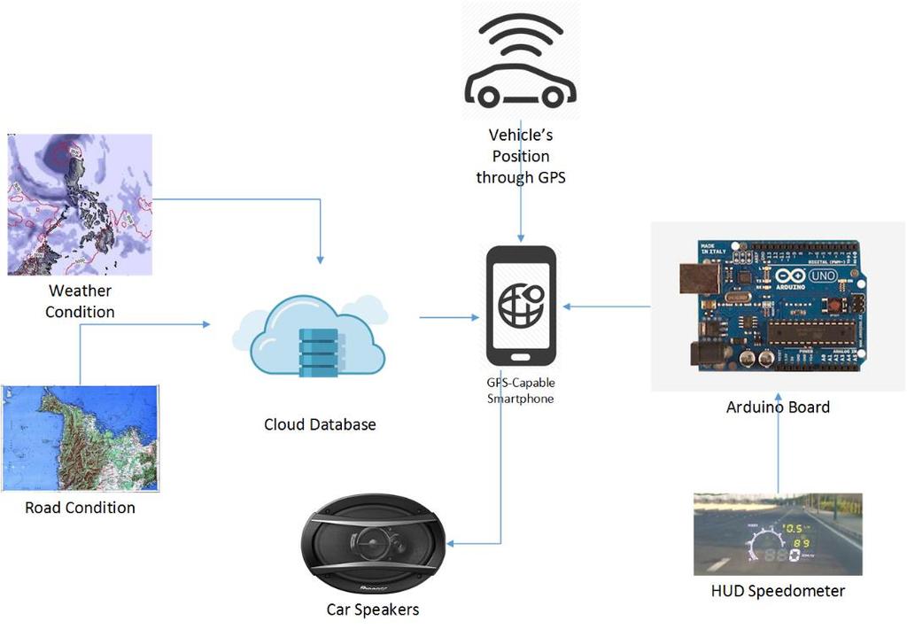
7 Flowchart IPO Model Conceptual framework


8 Non-invasive Drowsiness Detection using Face and Eyes Image Processing with Smartphone GPS Reporting and Recording System Fatality involved in drowsy driving Photo: and Statement of the problem Vehicular accidents are caused by drowsy drivers due to fatigue and exhaustion, or sometimes due to drunk driving. 21% of fatal accidents involved in a drowsy driver Drunk driving causes 50% of all the accidents occurring based on a statistic by a U.S State department. Objectives Monitor the heart rate and the eye movement of the driver Allow communication between the device and the government agency such as Pilipinas 911 to provide assistance to the driver in case of drowsiness. Prevent road accidents from happening due to drowsy drivers. Notify the driver with recommended speed

9 How it works Image from Eyes Face detection is done to locate the face and to verify if the person can be seen Eye localization is done to locate the coordinates of the Eyes An image of the eye is then taken for processing PERCLOS An SVM trained on HOG is used to determine and classify the eye whether it is closed, or not A measurement of the eyes being closed over time would be taken Sensor Reading Heart rate is measured in addition to PERCLOS measurement as a means of obtaining whether drowsy or not. Also provides a means of checking for false positives in the PERCLOS measurements since the driver also blinks and glances at the side mirrors from time to time. Drowsiness Algorithm PERCLOS data and heart rate data is then analyzed to determine whether the data obtained is considered as a Drowsy Count A drowsy count is obtained when the threshold from the PERCLOS or Heart rate sensor is crossed Alarm/Warning Phase Alarm Turn On When the threshold are met, the Buzzer will turn on to signal the driver that he has been detected drowsy and at the same time wake him up. It also means that he is advised to find a place to park the car The Buzzer would turn off only when the Accelerometer senses that the car is Stationary PILIPINAS 911 Responsible Authorities would be then notified of the Drowsy driver where the Information of the regarding the person would be given such as Current Location and Identification details Outcomes People who are driving, tired from their work, should be less prone from car accidents Enforcers will easily capture reckless drivers. Conceptual framework Flowchart
Texas A&M University
 Texas A&M University CVEN 658 Civil Engineering Applications of GIS Hotspot Analysis of Highway Accident Spatial Pattern Based on Network Spatial Weights Instructor: Dr. Francisco Olivera Author: Zachry
Who needs a spotter? AGENDA Role of a Spotter Circle of Safety Parking Practices
 Who needs a spotter? AGENDA Role of a Spotter Circle of Safety Parking Practices The Role of a Spotter To minimize potential backing and equipment incidents by communicating the hazards present with the
Your web browser (Safari 7) is out of date. For more security, comfort and. the best experience on this site: Update your browser Ignore
 is out of date. For more security, comfort and. the best experience on this site: Update your browser Ignore") Your web browser (Safari 7) is out of date. For more security, comfort and Activityengage the best experience on this site: Update your browser Ignore Introduction to GIS What is a geographic information
Your web browser (Safari 7) is out of date. For more security, comfort and Activityengage the best experience on this site: Update your browser Ignore Introduction to GIS What is a geographic information
Whether you are driving or walking, if you come to a flooded road, Turn Around Don't Drown
 Whether you are driving or walking, if you come to a flooded road, Turn Around Don't Drown You will not know the depth of the water nor will you know the condition of the road under the water. Many people
Mapping a Nation in 3D Singapore s Journey. Bryan Chew Registrar of Titles Assistant Chief Executive Singapore Land Authority
 Mapping a Nation in 3D Singapore s Journey Bryan Chew Registrar of Titles Assistant Chief Executive Singapore Land Authority Singapore Size - 719 sq km Population - 5.5 million Density 7,600/sq km Singapore
Safe Driving in Bad Weather Conditions
 Training Package 10/12 Safe Driving in Bad Weather Conditions Asia Industrial Gases Association 3 HarbourFront Place, #09-04 HarbourFront Tower 2, Singapore 099254 Internet: http//www.asiaiga.org Acknowledgement
106 PURDUE ENGINEERING EXTENSION DEPARTMENT
 106 PURDUE ENGINEERING EXTENSION DEPARTMENT distribution by stations can best be studied by examining Figs. 3 and 4. Figure 4 shows the frequency distribution between stations, and Fig. 3 shows the actual
Checklist: Deposing the Driver in an Auto Accident
 Checklist: Deposing the Driver in an Auto Accident 1. PERSONAL BACKGROUND All names ever used Present and past residences for 10 years If the deponent has rented a residence, get the name and address of
DEVELOPMENT OF TRAFFIC ACCIDENT ANALYSIS SYSTEM USING GIS
 DEVELOPMENT OF TRAFFIC ACCIDENT ANALYSIS SYSTEM USING GIS Masayuki HIRASAWA Researcher Traffic Engineering Division Civil Engineering Research Institute of Hokkaido 1-3 Hiragishi, Toyohira-ku, Sapporo,
Thilo Becker
 Friedrich List Faculty of Transport and Traffic Science, Chair of Transport Ecology CAN THE CONCEPT OF ENVIRONMENTAL JUSTICE IN TRANSPORT BE TRANSFERRED TO CITIES OF THE SOUTH? A CASE STUDY OF NAIROBI
Road Weather Management Program
 Road Weather Management Program AASHTO/TRB Joint Maintenance Conference: Highway Safety & Reliability (Winter Maintenance and Highway Safety and Reliability) 7/22/2015 Gabe Guevara. P.E. FHWA Office of
BAD WEATHER DOESN T CAUSE ACCIDENTS
 March 15, 1997 It is with mixed feelings of humor and dismay that persons in the field of traffic safety read frequent headlines in the newspapers--even the largest dailies--blaming the weather for automobile
10/18/2016 The Hoosier Co. Inc W. 86th Street, Indianapolis, IN
 10/18/2016 The Hoosier Co. Inc. 5421 W. 86th Street, Indianapolis, IN 46268 1 Today s Topics Weather impacts What is RWIS? How old is this tool? Key RWIS Technology/Innovation Key RWIS sensing parameters
Unit 1, Lesson 3 What Tools and Technologies Do Geographers Use?
 Unit 1, Lesson 3 What Tools and Technologies Do Geographers Use? Geographers use a variety of tools and technologies in investigating geographic questions. Maps and globes both represent the earth, but
Flash Flood, Scales and Societal Impacts
 Flash Flood, Scales and Societal Impacts Isabelle RUIN - isar@ucar.edu National Center for Atmospheric Research Boulder, CO 4 Corners Emergency Management Conference Branson, MO December, 2008 Flash flood
Evaluation of fog-detection and advisory-speed system
 Evaluation of fog-detection and advisory-speed system A. S. Al-Ghamdi College of Engineering, King Saud University, P. O. Box 800, Riyadh 11421, Saudi Arabia Abstract Highway safety is a major concern
ALASKA ITS. Vehicles and Observations in the cloud
 ALASKA ITS Vehicles and Observations in the cloud 1 YOUR PRESENTERS Wilf Nixon, Salt Institute Mark DeVries, Vaisala Dan Schacher, ADOT&PF 2 Today s Agenda A Cloud Based Overview connected and autonomous
Implication of GIS Technology in Accident Research in Bangladesh
 Journal of Bangladesh Institute of Planners ISSN 2075-9363 Vol. 8, 2015 (Printed in December 2016), pp. 159-166, Bangladesh Institute of Planners Implication of GIS Technology in Accident Research in Bangladesh
Emergency Traffic Management In the Case of Severe Winter Conditioins
 Emergency Traffic Management In the Case of Severe Winter Conditioins Presentation on the Project Workshop Organizing Emergency Management Strategies for the Transport Sector with the Use of innovative
GIS Workshop Data Collection Techniques
 GIS Workshop Data Collection Techniques NOFNEC Conference 2016 Presented by: Matawa First Nations Management Jennifer Duncan and Charlene Wagenaar, Geomatics Technicians, Four Rivers Department QA #: FRG
Driving at night. Harris Driving school. Harris Driving School
 Harris Driving school Driving at night Harris Driving School Phone: 087 2448951 / 01 2868339 Email: info@harrisdrivingschool.ie Web: www.harrisdrivingschool.ie 1 Driving at Night You ll find you are very
Smart Home System using Rasperry Pi
 Smart Home System using Rasperry Pi Sebastian(Xin) HUANG Shanghai Jiao Tong University Student ID: 1162609010040 Xavier(Qiwei) XU Shanghai Jiao Tong University Student ID: 1162609010014 Abstract In this
Unit 1, Lesson 2. What is geographic inquiry?
 What is geographic inquiry? Unit 1, Lesson 2 Understanding the way in which social scientists investigate problems will help you conduct your own investigations about problems or issues facing your community
AN ANALYSIS ON THE TRAFFIC ACCIDENTS TOURIST AT CASE STUDY: NANTOU COUNTY
 AN ANALYSIS ON THE TRAFFIC ACCIDENTS TOURIST AT CASE STUDY: NANTOU COUNTY Jau-Ming Su 1, Yu-Ming Wang 2 1 Chung Hua University, Ph.D.program of Technology Management, No. 707, Sec. 2, WuFu Rd., Hsin Chu,
If you aren t familiar with Geographical Information Systems (GIS), you. GIS, when combined with a database that stores response information,
, you. GIS, when combined with a database that stores response information,") Geographical Information Systems in EMS By William E. Ott If you aren t familiar with Geographical Information Systems (GIS), you should take a look at what GIS can offer you as an EMS manager. GIS, when
Geographical Information Systems in EMS By William E. Ott If you aren t familiar with Geographical Information Systems (GIS), you should take a look at what GIS can offer you as an EMS manager. GIS, when
Spatiotemporal Analysis of Urban Traffic Accidents: A Case Study of Tehran City, Iran
 Spatiotemporal Analysis of Urban Traffic Accidents: A Case Study of Tehran City, Iran January 2018 Niloofar HAJI MIRZA AGHASI Spatiotemporal Analysis of Urban Traffic Accidents: A Case Study of Tehran
The Five Themes of Geography Identification Slide Show. Developed by Joseph Naumann
 The Five Themes of Geography Identification Slide Show Developed by Joseph Naumann 1 5 Themes & Geographic Questions PLACE LOCATION HUMAN ENVIRONMENT/ INTERACTION REGION MOVEMENT 2 Location determining
[Lee, 5(1): January 2018] ISSN DOI /zenodo Impact Factor
![[Lee, 5(1): January 2018] ISSN DOI /zenodo Impact Factor](/thumbs/95/126338257.jpg "[Lee, 5(1): January 2018] ISSN DOI /zenodo Impact Factor") GLOBAL JOURNAL OF ENGINEERING SCIENCE AND RESEARCHES EVALUATION OF IMPROVED VARIABLE SPEED LIMIT SIGNS UNDER FOGGY CONDITIONS Minsoo Jin 1, Sukki Lee *2, Wonil Park 3 & Chulyong Kim 4 1,3 Research Specialist,
GLOBAL JOURNAL OF ENGINEERING SCIENCE AND RESEARCHES EVALUATION OF IMPROVED VARIABLE SPEED LIMIT SIGNS UNDER FOGGY CONDITIONS Minsoo Jin 1, Sukki Lee *2, Wonil Park 3 & Chulyong Kim 4 1,3 Research Specialist,
L ight color influence on obstacle recognition in road lighting. 1. Introduction
 Computer Applications in Electrical Engineering L ight color influence on obstacle recognition in road lighting Małgorzata Górczewska, Sandra Mroczkowska, Przemysław Skrzypczak Poznań University of Technology
Expanding Canada s Rail Network to Meet the Challenges of the Future
 Expanding Canada s Rail Network to Meet the Challenges of the Future Lesson Overview Rail may become a more popular mode of transportation in the future due to increased population, higher energy costs,
Colorado Academic Standards for High School Science Earth Systems Science
 A Correlation of Pearson 12 th Edition 2015 Colorado Academic Standards Introduction This document demonstrates the alignment between, 12 th Edition, 2015, and the, Earth Systems Science. Correlation page
Dust Storms in Arizona: The Challenge to Ensure Motorist Safety Jennifer Toth, P.E. Deputy Director for Transportation
 Dust Storms in Arizona: The Challenge to Ensure Motorist Safety Jennifer Toth, P.E. Deputy Director for Transportation Arizona Department of Transportation AASHTO Extreme Weather Event Symposium May 21,
Improving the travel time prediction by using the real-time floating car data
 Improving the travel time prediction by using the real-time floating car data Krzysztof Dembczyński Przemys law Gawe l Andrzej Jaszkiewicz Wojciech Kot lowski Adam Szarecki Institute of Computing Science,
MECHANICS DESCRIBING MOVEMENT
 MECHANICS DESCRIBING MOVEMENT Instantaneous speed & velocity Graphs of Motion Equations of Motion QUICK REVISION DISTANCE DISPLACEMENT VECTORS SCALARS SPEED VELOCITY ACCELERATION TICKER TIMERS THE DIFFERENCE
Weather Information for Road Managers
 Weather Information for Road Managers by Paul A. Pisano, Lynette C. Goodwin and Andrew D. Stern How Does Weather Affect Roads? The complex interactions between weather and roads have major affects on traffic
Opportunities to Improve Work Zone & Road Weather Management with Connected Vehicles
 Connected Vehicle Tracking to Improve Operational Efficiency Opportunities to Improve Work Zone & Road Weather Management with Connected Vehicles August 26, 2015 Gabriel Guevara TRB Webinar: Connected
Transportation and Road Weather
 Portland State University PDXScholar TREC Friday Seminar Series Transportation Research and Education Center (TREC) 4-18-2014 Transportation and Road Weather Rhonda Young University of Wyoming Let us know
Visibility Estimation of Traffic Signals under Rainy Weather Conditions for Smart Driving Support
 2012 15th International IEEE Conference on Intelligent Transportation Systems Anchorage, Alaska, USA, September 16-19, 2012 Visibility Estimation of Traffic Signals under Rainy Weather Conditions for Smart
FEDERAL RESOLUTION PROPOSAL INTRODUCTION FORM
 State of California California Senior Legislature FEDERAL RESOLUTION PROPOSAL INTRODUCTION FORM NAME: Senior Senator Lawrence I. Hartmann PHONE: 805-646-3587 Co-author(s): Senior Assemblywoman June Glasmeier
L.S. Lee* Hong Kong Observatory, Hong Kong, China
 2.5 COMPREHENSIVE AND LOCATION-SPECIFIC LIGHTNING INFORMATION SERVICE IN HONG KONG L.S. Lee* Hong Kong Observatory, Hong Kong, China 1. INTRODUCTION The Hong Kong Observatory (HKO) set up a lightning location
10/18/2016 The Hoosier Co. Inc W. 86th Street, Indianapolis, IN
 10/18/2016 The Hoosier Co. Inc. 5421 W. 86th Street, Indianapolis, IN 46268 1 Agenda What is RWIS? What options are available? Innovation/Improvement in Winter Operations & Maintenance Key RWIS sensing
NEWS RELEASE. Province boosts winter highway safety measures
 For Immediate Release 2018TRAN0045-000567 April 4, 2018 NEWS RELEASE Province boosts winter highway safety measures VICTORIA Following an intense winter, the is undertaking several improvements to make
Snow Plow Safety Quick Reference Guide
 PUBLIC WORKS INITIATIVE Snow Plow Safety Quick Reference Guide INTRODUCTION This quick reference guide highlights snow removal/snow plow safety practices. Its purpose is to help prevent personal injury
Lesson 6: Graphs of Linear Functions and Rate of Change
 Lesson 6 Lesson 6: Graphs of Linear Functions and Rate of Change Classwork Opening Exercise Functions 1, 2, and 3 have the tables shown below. Examine each of them, make a conjecture about which will be
Transport. Pupil Booklet
 Duncanrig Secondary School East Kilbride S3 Physics Elective Transport Pupil Booklet Name: Class: Aspects of the following outcomes in bold are covered by this topic of work. SCN 4-07a I can use appropriate
MeteoGroup RoadMaster. The world s leading winter road weather solution
 MeteoGroup RoadMaster The world s leading winter road weather solution Discover why RoadMaster is the world s leading winter road weather solution. Managing winter road maintenance means that you carry
Extracting mobility behavior from cell phone data DATA SIM Summer School 2013
 Extracting mobility behavior from cell phone data DATA SIM Summer School 2013 PETER WIDHALM Mobility Department Dynamic Transportation Systems T +43(0) 50550-6655 F +43(0) 50550-6439 peter.widhalm@ait.ac.at
Forecasts from the Strategy Planning Model
 Forecasts from the Strategy Planning Model Appendix A A12.1 As reported in Chapter 4, we used the Greater Manchester Strategy Planning Model (SPM) to test our long-term transport strategy. A12.2 The origins
Choosing a Safe Vehicle Challenge: Analysis: Measuring Speed Challenge: Analysis: Reflection:
 Activity 73: Choosing a Safe Vehicle Challenge: Which vehicle do you think is safer? 1. Compare the features you listed in the data evidence section to the features listed on the worksheet. a. How are
Using Geographical Information System (GIS) Techniques in Mapping Traffic Situation along Selected Road Corridors in Lagos Metropolis, Nigeria
 Techniques in Mapping Traffic Situation along Selected Road Corridors in Lagos Metropolis, Nigeria") Using Geographical Information System (GIS) Techniques in Mapping Traffic Situation along Selected Road Corridors in Lagos Metropolis, Nigeria Adebayo. H. Oluwasegun Department of Geography & Regional
Using Geographical Information System (GIS) Techniques in Mapping Traffic Situation along Selected Road Corridors in Lagos Metropolis, Nigeria Adebayo. H. Oluwasegun Department of Geography & Regional
Urban Planning Word Search Level 1
 Urban Planning Word Search Level 1 B C P U E C O S Y S T E M P A R E U O E U R B A N P L A N N E R T N S T D H E C O U N T Y G E R E R D W R E N I C I T Y C O U N C I L A A A S U G G C I L A G P R I R
A Paradox on Traffic Networks
 A Paradox on Traffic Networks Dietrich Braess Bochum Historical remarks. The detection of the paradox is also counterintuitive Is the mathematical paradox consistent with the psychological behavior of
Traffic Control Weather Policy
 Traffic Control Policy can plan a huge factor in our ability to set up, maintain and remove a closure safely. There are many weather factors that require consideration when traffic control is to be in
FHWA Road Weather Management Program Update
 FHWA Road Weather Management Program Update 2015 Winter Maintenance Peer Exchange Bloomington, MN September 21-25, 2015 Gabe Guevara FHWA Office of Operations Road Weather Management Team 2015 Winter Maintenance
What are Intelligent Transportation Systems? Major ITS Areas
 Intelligent Transportation Systems in Small Cities and Rural Areas Indiana Road School March 20, 2001 Steven Beningo Federal Highway Administration Midwestern Resource Center What are Intelligent Transportation
Winter guide for HGV drivers
 Winter guide for HGV drivers How to keep safe during the winter period Know your responsibilities, be informed and be prepared: As a professional driver, it is your responsibility to make allowance for
A Technique for Importing Shapefile to Mobile Device in a Distributed System Environment.
 A Technique for Importing Shapefile to Mobile Device in a Distributed System Environment. 1 Manish Srivastava, 2 Atul Verma, 3 Kanika Gupta 1 Academy of Business Engineering and Sciences,Ghaziabad, 201001,India
GIS INTEGRATION OF DATA COLLECTED BY MOBILE GPSSIT
 GIS INTEGRATION OF DATA COLLECTED BY MOBILE GPSSIT S.Savaş DURDURAN, Özşen ÇORUMLUOĞLU, Đbrahim KALAYCI and Fatih GÜL Selcuk University, Geodesy and Photogrammetry Dept. Konya-TURKĐYE ABSTRACT: Rapid developments
Smart use of Geographic Information System (GIS) platform for delivering weather information and nowcasting services
 platform for delivering weather information and nowcasting services") Smart use of Geographic Information System (GIS) platform for delivering weather information and nowcasting services C. K. Pan Hong Kong Observatory Hong Kong, China It is a world of beauty Source: Image
Smart use of Geographic Information System (GIS) platform for delivering weather information and nowcasting services C. K. Pan Hong Kong Observatory Hong Kong, China It is a world of beauty Source: Image
Earth Science (Tarbuck, et al) 2009 Correlated to: Colorado Academic Standards Science (High School)
 2009 Correlated to: Colorado Academic Standards Science (High School)") Content Area: Science Standard: Earth Systems Science Prepared Graduates: Describe and interpret how Earth's geologic history and place in space are relevant to our understanding of the processes that
Content Area: Science Standard: Earth Systems Science Prepared Graduates: Describe and interpret how Earth's geologic history and place in space are relevant to our understanding of the processes that
Changes in the Spatial Distribution of Mobile Source Emissions due to the Interactions between Land-use and Regional Transportation Systems
 Changes in the Spatial Distribution of Mobile Source Emissions due to the Interactions between Land-use and Regional Transportation Systems A Framework for Analysis Urban Transportation Center University
Tornadoes Impacting Interstates: Service and Societal Considerations
 Tornadoes Impacting Interstates: Service and Societal Considerations Scott F. Blair NOAA / National Weather Service, Topeka, Kansas Elizabeth P. K. Lunde NOAA / National Weather Service, Topeka, Kansas
Give 4 advantages of using ICT in the collection of data. Give. Give 4 disadvantages in the use of ICT in the collection of data
 Give 4 advantages of using ICT in the collection of data can use a handheld GPS to get accurate location information which can be used to show data linked to specific locations within a GIS can collect
Program- Traffic decongestion and fluidization in Satu Mare municipality
 Program- Traffic decongestion and fluidization in Satu Mare municipality Portfolio: Mayor Dr. Coica Costel Dorel Description of the program Decongestion and fluidization of traffic in Satu Mare municipality
Wireless Network Security Spring 2016
 Wireless Network Security Spring 2016 Patrick Tague Class #19 Vehicular Network Security & Privacy 2016 Patrick Tague 1 Class #19 Review of some vehicular network stuff How wireless attacks affect vehicle
GIS = Geographic Information Systems;
 What is GIS GIS = Geographic Information Systems; What Information are we talking about? Information about anything that has a place (e.g. locations of features, address of people) on Earth s surface,
Responsive Traffic Management Through Short-Term Weather and Collision Prediction
 Responsive Traffic Management Through Short-Term Weather and Collision Prediction Presenter: Stevanus A. Tjandra, Ph.D. City of Edmonton Office of Traffic Safety (OTS) Co-authors: Yongsheng Chen, Ph.D.,
What is GIS? ESRI Canada. August 2011
 What is GIS? ESRI Canada August 2011 Geography Matters! Environmental Park Management Agriculture Public Utilities Health Care Emergency 911 Real Estate Marketing Environmental What are the effects of
Building a National Data Repository
 Building a National Data Repository Mladen Stojic, Vice President - Geospatial 1/30/2013 2012 Intergraph Corporation 1 Information has meaning and gives power only when shared and distributed. Information,
Designing smart & Resilient cities:
 Designing smart & Resilient cities: How can Egyptian cities learn from an emerging global practice On the Cuspof Change Professor Samer Bagaeen FRICS MRTPI FRSA AoU 1. GLOBAL CHALLENGES POPULATION GROWTH,
H IG HWAY WINTER OPERATIONS SNOW REMOVAL AND ICE CONTROL POLICY. Revised January 4, 2016
 ! H IG HWAY WINTER OPERATIONS SNOW REMOVAL AND ICE CONTROL POLICY Adopted January 11, 2010 Revised January 4, 2016 Pol icy It is the goal and intent of the Town of Sullivan to provide timely, efficient
Leaving the Ivory Tower of a System Theory: From Geosimulation of Parking Search to Urban Parking Policy-Making
 Leaving the Ivory Tower of a System Theory: From Geosimulation of Parking Search to Urban Parking Policy-Making Itzhak Benenson 1, Nadav Levy 1, Karel Martens 2 1 Department of Geography and Human Environment,
2016 APWA Snow Conference. Web-based GIS for Municipal Snow Operations
 2016 APWA Snow Conference Web-based GIS for Municipal Snow Operations Christopher M. Cignoli, P.E. - Director of Public Works, Springfield, MA Bob Houldson - Director IT Services for the Department of
Driving Cycle and Road Grade on-board prediction for the optimal energy management in EV-PHEVs
 Driving Cycle and Road Grade on-board prediction for the optimal energy management in EV-PHEVs Borja Heriz Revuelta borja.heriz@tecnalia.com Alternative Powertrain Researcher Tecnalia Transport Business
Work Sheet. Adverse Condition Factors Module 9
 Work Sheet Adverse Condition Factors Module 9 Parent Answer Guide Lesson 1 Limited-visibility Conditions and Extreme Weather Topic 1 - Night Time Driving 1. List three things that are affected by night
ASIA GEOSPATIAL FORUM 2011 Eco-Friendly Walk Score Calculator Choosing a Place to Live with GIS
 ASIA GEOSPATIAL FORUM 2011 Eco-Friendly Walk Score Calculator Choosing a Place to Live with GIS Ko Ko Lwin and Yuji Murayama Division of Spatial Information Science Graduate School of Life and Environmental
GIS Geographical Information Systems. GIS Management
 GIS Geographical Information Systems GIS Management Difficulties on establishing a GIS Funding GIS Determining Project Standards Data Gathering Map Development Recruiting GIS Professionals Educating Staff
Creating a Staff Development Plan with Esri
 Creating a Staff Development Plan with Esri Michael Green David Schneider Guest Presenter: Shane Feirer, University of California Esri UC 2014 Technical Workshop Agenda What is a Staff Development Plan?
Meridian Environmental Technology, Inc.
 Meridian Environmental Technology, Inc. Providing Tomorrow s Technology Today Meridian is committed to the support of its clients through advancement of science and technology A National Leader in Road
Research Group Cartography
 Research Group Cartography Research Group Cartography Towards supporting wayfinding LBS components 1. Mobile devices 2. Communication Network 3. Positioning Component 4. Service and Application Provider
Eyes in the Sky & Data Analysis.
 Eyes in the Sky & Data Analysis How can we collect Information about Earth Climbing up Trees & Mountains Gathering Food Self Protection Understanding Surroundings By Travelling Collected Information Converted
A Broad View of Geospatial Technology & Systems
 A Broad View of Geospatial Technology & Systems Pete Large Vice President, Trimble On the shoulders of giants 1 Since their time, our ability to generate geospatial information has grown exponentially
TOWN OF GRAND FALLS WINDSOR
 TOWN OF GRAND FALLS WINDSOR DEPARTMENT OF ENGINEERING AND WORKS FREQUENTLY ASKED QUESTIONS FOR WINTER OPERATIONS... What streets are the first to be plowed & salted/sanded? The roads crews are each assigned
Geospatial natural disaster management
 Geospatial natural disaster management disasters happen. are you ready? Natural disasters can strike almost anywhere at any time, with no regard to a municipality s financial resources. These extraordinarily
CHALLENGE #1: ROAD CONDITIONS
 CHALLENGE #1: ROAD CONDITIONS Your forward collision warning system may struggle on wet or icy roads because it is not able to adjust for road conditions. Wet or slick roads may increase your stopping
Understand FORWARD COLLISION WARNING WHAT IS IT? HOW DOES IT WORK? HOW TO USE IT?
 Understand WHAT IS IT? Forward collision warning systems warn you of an impending collision by detecting stopped or slowly moved vehicles ahead of your vehicle. Forward collision warning use radar, lasers,
Modeling evacuation plan problems
 Chapter 7 Modeling evacuation plan problems In Section 3.1 we reviewed the recommendations that the UNESCO presented in [30] to develop volcanic emergency plans. In [18] is presented the state of art of
Motorists are urged to drive wisely and cautiously in all winter weather situations:
 Snow and Ice Snow and ice control is a central winter activity of the Milford Township road crew, especially during a rough winter. Milford Township is responsible for keeping 76.45 miles of roads passable
Reimaging GIS: Geographic Information Society. Clint Brown Linda Beale Mark Harrower Esri
 Reimaging GIS: Geographic Information Society Clint Brown Linda Beale Mark Harrower Esri 8 billion = Number of basemap requests per month on AGOL 14,000 = Unique requests per second 12,000 = New Items
5.1 Introduction. 5.2 Data Collection
 Chapter 5 Traffic Analysis 5.1 Introduction This chapter of the EIS assesses the traffic impacts of the proposed N5 Westport to Turlough Road Project (the proposed scheme). The proposed scheme will provide
Techniques for Science Teachers: Using GIS in Science Classrooms.
 Techniques for Science Teachers: Using GIS in Science Classrooms. After ESRI, 2008 GIS A Geographic Information System A collection of computer hardware, software, and geographic data used together for
Spatially Connected Government in Great Britain. Peter Hedlund CEO Ordnance Survey International
 Spatially Connected Government in Great Britain Peter Hedlund CEO Ordnance Survey International 1 Mapping is everywhere 2 Location - a vital component! 3 Location a meeting point for information? Postcode?
Introduction to Geographic Information Systems Dr. Arun K Saraf Department of Earth Sciences Indian Institute of Technology, Roorkee
 Introduction to Geographic Information Systems Dr. Arun K Saraf Department of Earth Sciences Indian Institute of Technology, Roorkee Lecture 01 What is Geographic Information Systems? I welcome to this
Innovation in mapping and photogrammetry at the Survey of Israel
 16, October, 2017 Innovation in mapping and photogrammetry at the Survey of Israel Yaron Felus and Ronen Regev Contents Why HD mapping? Government requirements Mapping regulations o Quality requirements
Winter Maintenance on Ontario s Highways
 Ministry of Transportation Winter Maintenance on Ontario s Highways MTO Eastern Region November 18, 2015, Northumberland County Council Outline 1. Winter Maintenance Areas - Eastern Region 2. Winter Maintenance
Smoke Fog Superfog - Smoke and Fog mixture Heavy rain and wind
 Smoke Fog Superfog - Smoke and Fog mixture Heavy rain and wind Florida Highway Patrol Training Academy Fog forms when water evaporates from a surface or is added to the air. Super fog is a combination
UDOT Weather Program Traffic Operations Center
 UDOT Weather Program Traffic Operations Center Presentation Goals You MUST account for weather in your Traffic Management program Provide you with information on proven tools and strategies You NEED a
Different types of maps and how to read them.
 Different types of maps and how to read them. A map is a picture or representation of the Earth's surface, showing how things are related to each other by distance, direction, and size. Maps have been
NAME: DATE: Leaving Certificate GEOGRAPHY: Maps and aerial photographs. Maps and Aerial Photographs
 NAME: DATE: Leaving Certificate Geography Maps and Aerial Photographs Please see Teachers Notes for explanations, additional activities, and tips and suggestions. Learning Support Vocabulary, key terms
The stopping distance of a car is the sum of the thinking distance and the braking distance.
 The stopping distance of a car is the sum of the thinking distance and the braking distance. The table below shows how the thinking distance and braking distance vary with speed. Speed in m / s Thinking