SH RI Events. Influence From Patterns Of Different Scale
|
|
|
- Rodger Marsh
- 6 years ago
- Views:
Transcription
1 SH RI Events Influence From Patterns Of Different Scale

2 RI Explanation * Rapid intensification, approximately an increase of 2 Dvorak T-numbers or 30 knots in 24 hours, frequently occurs in JTWC forecast basins. In general, rapid intensification is likely if dual outflow channels develop. TUTT cell are associated w/ri Mid-latitude trough also *
3 SH Observations and Prelim Conclusion JTWC 06Z & 18Z Two RI events 08/12Z to 09/00Z 10/00Z to 11/06Z Jan RI #1 resulted by increased outflow aided by small TUTT cell (UL cyc) RI #2 resulted from mid-latitude trough and TUTT enhancement Both events mis-initialized & mis-forecast by models & JTWC CHIPS as an RI tool?

4
5 TC 07P (Ian) Working Intensity Plot Max intensity 130kts


6 First RI Event Location: Between Fiji and Samoa Islands


7 First RI Event: 30kt increase in 12 hours 08/12Z 09/00Z


8 2nd RI Event 10/06Z 35kt Increase/24hrs


9 2 nd RI Occurred Near and in Tonga (Vava u and Ha apai Island Groups)
10 #1 08/12Z (55kts) 09/00Z (85kts)
11 #2 10/06Z (95kts) 11/06Z (130kts)
12 FMQ -17 WV loop SH r_archive.php
13 1 st RI Presentation

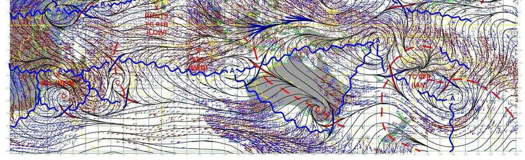
14 08/12Z JTWC 200mb Streamline Anal

15 08/12Z JTWC 200mb Streamline Anal
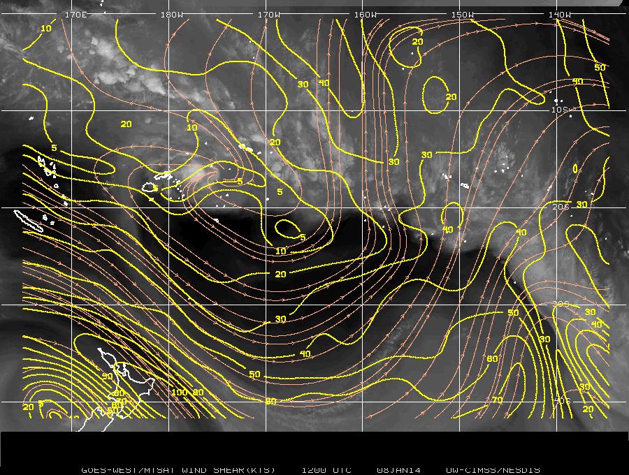
16 SEPacificDeepShearLarge.pn g

17 SEPacificMidUpperWindsLarg e.png
18 08/18Z Warning REMARKS Z POSITION NEAR 16.7S 176.7W. TROPICAL CYCLONE (TC) 07P (IAN), LOCATED APPROXIMATELY 287 NM EAST- NORTHEAST OF SUVA, FIJI, HAS TRACKED EASTWARD AT 01 KNOTS OVER THE PAST SIX HOURS. ANIMATED INFRARED SATELLITE IMAGERY DEPICTS A CONSOLIDATING LOW-LEVEL CIRCULATION CENTER (LLCC) WITH CURVED BANDING WRAPPING INTO A CENTRAL DENSE OVERCAST FEATURE. A Z SSMIS 91 GHZ MICROWAVE IMAGE REVEALS DEEP CONVECTIVE BANDING TIGHTLY WRAPPED INTO AN APPARENT MICROWAVE EYE, THEREFORE, THERE IS HIGH CONFIDENCE IN THE CURRENT POSITION. THE INITIAL INTENSITY OF 60 KNOTS IS BASED ON DVORAK ESTIMATES RANGING FROM 55 TO 77 KNOTS FROM PGTW AND KNES. TC 07P IS CURRENTLY LOCATED IN A WEAK STEERING ENVIRONMENT, BETWEEN A NEAR-EQUATORIAL RIDGE (NER) TO THE NORTH AND A SUB-TROPICAL RIDGE (STR) TO THE SOUTH, RESULTING IN THE QUASI- STATIONARY MOVEMENT. AFTER TAU 24, A MID-LATITUDE TROUGH WILL MOVE OVER THE AREA, DOMINATING THE STEERING PATTERN AND ALLOWING THE SYSTEM TO ACCELERATE SOUTHEASTWARD THROUGH THE END OF THE FORECAST PERIOD. UPPER-LEVEL ANALYSIS INDICATES FAVORABLE VERTICAL WIND SHEAR (VWS) AND INCREASING POLEWARD OUTFLOW EVIDENT IN THE WATER VAPOR IMAGERY. IN ADDITION TO THE FAVORABLE UPPER-LEVEL CONDITIONS, THE WARM SEA SURFACE TEMPERATURE (SST) WILL FURTHER SUPPORT A PEAK INTENSITY OF 100 KNOTS IN 48 HOURS. BY TAU 72, TC 07P IS EXPECTED TO WEAKEN AS THE SYSTEM REMAINS ON A SOUTHEASTWARD TRACK, ENCOUNTERING STRONGER VWS AND COOLER SST. TC 07P IS FORECAST TO BEGIN EXTRA- TROPICAL TRANSITION (ETT) BY TAU 96 AND COMPLETE ETT BY TAU 120. DUE TO THE CURRENTLY WEAK STEERING ENVIRONMENT, THERE IS LOW CONFIDENCE IN FORECAST TRACK IN THE NEAR TERM. DYNAMIC MODEL GUIDANCE INDICATES BETTER AGREEMENT IN THE LATER TAUS, LENDING A HIGH CONFIDENCE IN THE OFFICIAL FORECAST TRACK. MAXIMUM SIGNIFICANT WAVE HEIGHT AT Z IS 15 FEET. NEXT WARNINGS AT Z AND Z.//

19 08/06Z Intensity Plot
20 08/18Z Intensity Plot

21
22 RAMMB 07P Loop 08/00Z 0906Z me/loop.asp?product=16kmgwvp&storm_identifi er=sh072014&starting_image=2014sh07_16k MGWVP_ GIF&ending_image=2 014SH07_16KMGWVP_ GIF


23


24

25


26


27
28 WXMAP Data Follows 08 Jan 0600Z and 1800Z NAVGEM Z not in WXMAP archives Analyses Z Anal weaker troughing depicted Working BT indicates RI period CIRA WV indicates well-defined TUTT cell

29

30
31 Two RI /steep slope regions #1 08/12Z (55kts) 09/00Z (85kts)
32 Two RI /steep slope regions #2 10/00Z (90kts) 11/06Z (130kts)
33 2 nd RI No clear smoking gun CIRA WV data suggests: Narrow TUTT to west and southwest UL northwest flow associated w/mid-latitude trough moving from Australia eastward TUTT cell to SE????


34 10/06Z JTWC Warning 10kt Intensity Increase 10/06Z 11/06Z
 11/06Z (130kts)")
35 Two RI /steep slope regions #2 10/00Z (90kts) 11/06Z (130kts)


36 Extracted from OHANA storm folder
37 Extracted fm ATCF (default setting)
38 10/06Z & 10/18Z Remarks: Nearly Similar w/30kt Intensity Change TAU 0 = 90kts Z POSITION NEAR 18.2S 174.9W. TROPICAL CYCLONE 07P (IAN), LOCATED APPROXIMATELY 371 NM EAST OF SUVA, FIJI, HAS TRACKED SOUTHEASTWARD AT 06 KNOTS OVER THE PAST SIX HOURS. ANIMATED MULTISPECTRAL SATELLITE IMAGERY (MSI) SHOWS TC 07P HAS STARTED TO STEADILY TRACK ALONG THE WESTERN PERIPHERY OF THE NEAR EQUATORIAL RIDGE (NER) AS IT EXTENDS FROM THE NORTHEASTERN QUADRANT OF THE SYSTEM TO THE SUB- TROPICAL RIDGE LOCATED TO THE SOUTHEAST OF TC 07P. MSI ALSO SHOWS THE EYE HAS EXPANDED SLIGHTLY AND CLEARED OVER THE PAST FEW HOURS. UPPER LEVEL ANALYSIS INDICATES THE TRANSITORY MID-LATITUDE TROUGH TO THE SOUTH OF TC 07P HAS ENHANCED THE THE POLEWARD OUTFLOW AND HAS ALLOWED THE SYSTEM TO MAINTAIN AS AN INTENSE TROPICAL CYCLONE WITH FAVORABLE VERTICAL WIND SHEAR (VWS). IN ADDITION TO THE FAVORABLE UPPER-LEVEL CONDITIONS, WARM SEA SURFACE TEMPERATURES (SSTS) WILL FURTHER SUPPORT A PEAK INTENSITY OF 100 KNOTS WITHIN THE NEXT 24 HOURS. BY TAU 72, TC 07P IS EXPECTED TO WEAKEN AS THE SYSTEM REMAINS ON A SOUTHEASTWARD TRACK, ENCOUNTERING STRONGER VWS AND COOLER SSTS. TC 07P IS FORECAST TO BEGIN EXTRA-TROPICAL TRANSITION (ETT) BY TAU 72 AND COMPLETE ETT BY TAU 120. IMPROVEMENTS IN THE STEERING ENVIRONMENT AND MODEL GUIDANCE LEADS TO HIGH CONFIDENCE IN THE FORECAST TRACK. MAXIMUM SIGNIFICANT WAVE HEIGHT AT Z IS 23 FEET. NEXT WARNINGS AT Z AND Z.// TAU 0 = 120kts Z POSITION NEAR 19.3S 174.6W. TROPICAL CYCLONE 07P (IAN), LOCATED APPROXIMATELY 363 NM SOUTHWEST OF PAGO PAGO, HAS TRACKED SOUTHWARD AT 05 KNOTS OVER THE PAST SIX HOURS. ANIMATED INFRARED (IR) SATELLITE IMAGERY SHOWS TC 07P TRACKING ALONG THE WESTERN PERIPHERY OF THE NEAR EQUATORIAL RIDGE (NER) EXTENDING FROM THE NORTHEASTERN QUADRANT OF THE SYSTEM TO THE SUB-TROPICAL RIDGE LOCATED TO THE SOUTHEAST OF TC 07P. THE IR ANIMATION DEPICTS AN INTENSE, TIGHTLY WRAPPED SYSTEM WITH AN 18 NM EYE FEATURE. A Z SSMIS MICROWAVE IMAGE REVEALS A SHARPLY DEFINED EYEWALL WITH SEVERAL DEEP CONVECTIVE BANDS SPIRALING OUT FROM THE SYSTEM CENTER. THE INITIAL POSITION IS BASED ON THE EYE FEATURE IN THE IR ANIMATION WITH HIGH CONFIDENCE. THE INITIAL INTENSITY HAS BEEN ASSESSED AT 120 KNOTS BASED ON AN AVERAGE OF DVORAK INTENSITY ESTIMATES RANGING FROM KNOTS. UPPER LEVEL ANALYSIS INDICATES THE TRANSITORY MID-LATITUDE TROUGH TO THE SOUTH OF TC 07P HAS CONTINUED TO ENHANCE THE POLEWARD OUTFLOW AND ALLOWED THE SYSTEM TO CONTINUE TO INTENSIFY. IN ADDITION TO THE FAVORABLE UPPER-LEVEL CONDITIONS, WARM SEA SURFACE TEMPERATURES (SSTS) WILL FURTHER SUPPORT A PEAK INTENSITY OF 125 KNOTS WITHIN THE NEXT 12 HOURS. A GRADUAL WEAKENING TREND IS EXPECTED THEREAFTER. BY TAU 72, TC 07P WILL BEGIN ENCOUNTERING STRONGER VWS AND COOLER SSTS, BEGINNING EXTRA-TROPICAL TRANSITION. TC 07P IS FORECAST TO COMPLETE ETT BY TAU 96. IMPROVEMENTS IN THE STEERING ENVIRONMENT AND MODEL GUIDANCE LEADS TO HIGH CONFIDENCE IN THE FORECAST TRACK. MAXIMUM SIGNIFICANT WAVE HEIGHT AT Z IS 25 FEET. NEXT WARNINGS AT Z AND Z.//
39 WTPS31 PGTW MSGID/GENADMIN/JOINT TYPHOON WRNCEN PEARL HARBOR HI// SUBJ/TROPICAL CYCLONE 07P (IAN) WARNING NR 010// RMKS/ 1. TROPICAL CYCLONE 07P (IAN) WARNING NR ACTIVE TROPICAL CYCLONE IN SOUTHPAC MAX SUSTAINED WINDS BASED ON ONE-MINUTE AVERAGE WIND RADII VALID OVER OPEN WATER ONLY --- WARNING POSITION: Z --- NEAR 18.0S 175.1W MOVEMENT PAST SIX HOURS DEGREES AT 06 KTS POSITION ACCURATE TO WITHIN 020 NM POSITION BASED ON EYE FIXED BY SATELLITE PRESENT WIND DISTRIBUTION: MAX SUSTAINED WINDS KT, GUSTS 110 KT WIND RADII VALID OVER OPEN WATER ONLY RADIUS OF 064 KT WINDS NM NORTHEAST QUADRANT 015 NM SOUTHEAST QUADRANT 015 NM SOUTHWEST QUADRANT 015 NM NORTHWEST QUADRANT RADIUS OF 050 KT WINDS NM NORTHEAST QUADRANT 030 NM SOUTHEAST QUADRANT 030 NM SOUTHWEST QUADRANT 030 NM NORTHWEST QUADRANT RADIUS OF 034 KT WINDS NM NORTHEAST QUADRANT 070 NM SOUTHEAST QUADRANT 080 NM SOUTHWEST QUADRANT 070 NM NORTHWEST QUADRANT REPEAT POSIT: 18.0S 175.1W WTPS31 PGTW MSGID/GENADMIN/JOINT TYPHOON WRNCEN PEARL HARBOR HI// SUBJ/TROPICAL CYCLONE 07P (IAN) WARNING NR 011// RMKS/ 1. TROPICAL CYCLONE 07P (IAN) WARNING NR ACTIVE TROPICAL CYCLONE IN SOUTHPAC MAX SUSTAINED WINDS BASED ON ONE-MINUTE AVERAGE WIND RADII VALID OVER OPEN WATER ONLY --- WARNING POSITION: Z --- NEAR 18.9S 174.8W MOVEMENT PAST SIX HOURS DEGREES AT 05 KTS POSITION ACCURATE TO WITHIN 020 NM POSITION BASED ON EYE FIXED BY SATELLITE PRESENT WIND DISTRIBUTION: MAX SUSTAINED WINDS KT, GUSTS 145 KT WIND RADII VALID OVER OPEN WATER ONLY RADIUS OF 064 KT WINDS NM NORTHEAST QUADRANT 015 NM SOUTHEAST QUADRANT 015 NM SOUTHWEST QUADRANT 015 NM NORTHWEST QUADRANT RADIUS OF 050 KT WINDS NM NORTHEAST QUADRANT 030 NM SOUTHEAST QUADRANT 030 NM SOUTHWEST QUADRANT 030 NM NORTHWEST QUADRANT RADIUS OF 034 KT WINDS NM NORTHEAST QUADRANT 070 NM SOUTHEAST QUADRANT 080 NM SOUTHWEST QUADRANT 070 NM NORTHWEST QUADRANT REPEAT POSIT: 18.9S 174.8W


40

41 10/12Z JTWC 200mb Streamline Analysis Zoomed

42 CIMSS 12Z No Anti over Eye???

43
44

45
46 RAMMB WV Loop 09/21Z 11/09Z me/loop.asp?product=16kmgwvp&storm_identifi er=sh072014&starting_image=2014sh07_16k MGWVP_ GIF&ending_image=2 014SH07_16KMGWVP_ GIF
47 Summary Apparent small features (e.g. Tutt Cell) not readily apparent in Large-scale data/analyses analyses, both numerical and manual Small features appear to enhance outflow already aided by synoptic or large scale features Need for forecaster to consider and factor into forecast for intensity and track. CHIPS depicted the RI

48 08/18Z Intensity Plot

")

49 Extracted fm ATCF (default setting)
Tri-Agency Forecast Discussion for August 24, 2010
 Created 1600 UTC August 24, 2010 Tri-Agency Forecast Discussion for August 24, 2010 GRIP Forecast Team: Cerese Inglish, Matt Janiga, Andrew Martin, Dan Halperin, Jon Zawislak, Ellen Ramirez, Amber Reynolds,
Current Details from the Joint Typhoon Warning Center
 Current Details from the Joint Warning Center COORDINATES: 10.2 north, 148.1 east (previous location: 10.1 north, 148.3 east) LOCATION: 520 kilometers (325 miles) southeast of Andersen Air Force Base,
A Tropical Cyclone with a Very Large Eye
 JANUARY 1999 PICTURES OF THE MONTH 137 A Tropical Cyclone with a Very Large Eye MARK A. LANDER University of Guam, Mangilao, Guam 9 September 1997 and 2 March 1998 1. Introduction The well-defined eye
Current Details from the Joint Typhoon Warning Center
 Current Details from the Joint Warning Center COORDINATES: 19.6 north, 125.5 east (previous location: 17.9 north, 130.3 east) LOCATION: 737 kilometers (458 miles) southeast of Taipei, Taiwan MOVEMENT:
Tropical Cyclones. Objectives
 Tropical Cyclones FIU Undergraduate Hurricane Internship Lecture 2 8/8/2012 Objectives From this lecture you should understand: Global tracks of TCs and the seasons when they are most common General circulation
Feel free to ask for help also, we will try our best to answer your question or at least direct you to where you can find the answer.
 Page 1 Objectives: Become familiar with online resources and image searching tools Interpret different types of satellite imagery Learn about the variety of different types of TCs Part 1: Browse available
AOMSUC-6 Training Event
 Effective use of high temporal and spatial resolution Himawari-8 data AOMSUC-6 Training Event Bodo Zeschke Australian Bureau of Meteorology Training Centre Australian VLab Centre of Excellence Content
Derrick Herndon and Chris Velden University of Wisconsin - Madison Cooperative Institute for Meteorological Satellite Studies
 CIMSS SATellite CONsensus (SATCON) Derrick Herndon and Chris Velden University of Wisconsin - Madison Cooperative Institute for Meteorological Satellite Studies Presented at International Workshop on Satellite
Lec 10: Interpreting Weather Maps
 Lec 10: Interpreting Weather Maps Case Study: October 2011 Nor easter FIU MET 3502 Synoptic Hurricane Forecasts Genesis: on large scale weather maps or satellite images, look for tropical waves (Africa
Extratropical transition of tropical cyclones: Operational forecasting challenges. Matthew Kucas Joint Typhoon Warning Center Pearl Harbor, HI, USA
 Extratropical transition of tropical cyclones: Operational forecasting challenges Matthew Kucas Joint Typhoon Warning Center Pearl Harbor, HI, USA Outline Motivation for discussion Brief overview of tropical
JTWC's Use of TRMM in Typhoon Forecast Operations
 Use of TRMM in Typhoon Forecast Operations JTWC's Use of TRMM in Typhoon Forecast Operations Slide 1/24 Use of TRMM in Typhoon Forecast Operations Slide 2/24 Opening Comments The current microwave satellite
Hurricane Structure: Theory and Application. John Cangialosi National Hurricane Center
 Hurricane Structure: Theory and Application John Cangialosi National Hurricane Center World Meteorological Organization Workshop Is this Tropical, Subtropical, or Extratropical? Subtropical Tropical Extratropical
Chapter 24. Tropical Cyclones. Tropical Cyclone Classification 4/19/17
 Chapter 24 Tropical Cyclones Tropical Cyclones Most destructive storms on the planet Originate over tropical waters, but their paths often take them over land and into midlatitudes Names Hurricane (Atlantic
Chapter 24 Tropical Cyclones
 Chapter 24 Tropical Cyclones Tropical Weather Systems Tropical disturbance a cluster of thunderstorms about 250 to 600 km in diameter, originating in the tropics or sub-tropics Tropical depression a cluster
TROPICAL CYCLONE TC 03A FOR THE PERIOD 3 RD JUNE TO 10 TH JUNE, 1998
 TROPICAL CYCLONE TC 03A FOR THE PERIOD 3 RD JUNE TO 10 TH JUNE, 1998 Hazrat Mir, Abdul Rashid, Waqarul Wheed Khan. Introduction: This report gives the review of cyclonic storm formed over the East Arabian
Predicting Tropical Cyclone Formation and Structure Change
 Predicting Tropical Cyclone Formation and Structure Change Patrick A. Harr Department of Meteorology Naval Postgraduate School Monterey, CA 93943-5114 phone: (831)656-3787 fax: (831)656-3061 email: paharr@nps.navy.mil
Hurricanes. Hurricanes are large, tropical storm systems that form and develop over the warm waters near the equator.
 Hurricanes Hurricanes are large, tropical storm systems that form and develop over the warm waters near the equator. They are responsible for weather that can devastate entire communities: Heavy rain --
(April 7, 2010, Wednesday) Tropical Storms & Hurricanes Part 2
 Tropical Storms & Hurricanes Part 2") Lecture #17 (April 7, 2010, Wednesday) Tropical Storms & Hurricanes Part 2 Hurricane Katrina August 2005 All tropical cyclone tracks (1945-2006). Hurricane Formation While moving westward, tropical disturbances
Lecture #17 (April 7, 2010, Wednesday) Tropical Storms & Hurricanes Part 2 Hurricane Katrina August 2005 All tropical cyclone tracks (1945-2006). Hurricane Formation While moving westward, tropical disturbances
Storm Summary for Hurricane Joaquin
 Storm Summary for Hurricane Joaquin Wednesday, September 30, 2015 at 5 PM EDT (Output from Hurrevac, based on National Hurricane Center Forecast Advisory #12) Joaquin is currently a Category 1 hurricane
Lectures on Tropical Cyclones
 Lectures on Tropical Cyclones Chapter 1 Observations of Tropical Cyclones Outline of course Introduction, Observed Structure Dynamics of Mature Tropical Cyclones Equations of motion Primary circulation
Hurricanes. April 14, 2009
 Tropical Weather & Hurricanes Chapter 15 April 14, 2009 Tropical meteorology Tropics characterized by seasonal wet and drier periods- wet when sun is nearly overhead at noon and inter-tropical convergence
STATE OF THE CLIMATE IN 2015
 STATE OF THE CLIMATE IN 2015 Special Supplement to the Bulletin of the American Meteorological Society Vol. 97, No. 8, August 2016 severed during the storm, and four days after the storm nearly 60% of
Storm Surge Modelling at the JRC. A. Annunziato
 Storm Surge Modelling at the JRC A. Annunziato Storm Surge Activities The following modelling activities are carried out at JRC Tsunami wave height forecast Cyclones Storm Surge The activities are performed
Tropical-Extratropical Transition
 Tropical-Extratropical Transition Extratropical Transition A significant number of tropical cyclones move into the midlatitudes and transform into extratropical cyclones. This process is generally referred
Issued by the: Climate Services Division Fiji Meteorological Service Nadi Airport. 27 October 2010 GENERAL STATEMENT
 Fiji Meteorological Service (FMS) Tropical Cyclone Guidance for Season 2010/11 for the Fiji and the Southwest Pacific RSMC Region 160E to 120W Equator to 25 South Issued by the: Climate Services Division
Synoptic Meteorology II: Petterssen-Sutcliffe Development Theory Application March 2015
 Synoptic Meteorology II: Petterssen-Sutcliffe Development Theory Application 10-12 March 2015 In our lecture on Petterssen-Sutcliffe Development Theory, we outlined the principle of selfdevelopment in
Anthony A. Rockwood Robert A. Maddox
 Anthony A. Rockwood Robert A. Maddox An unusually intense MCS produced large hail and wind damage in northeast Kansas and northern Missouri during the predawn hours of June 7 th, 1982. Takes a look at
Comments on: Increasing destructiveness of tropical cyclones over the past 30 years by Kerry Emanuel, Nature, 31 July 2005, Vol. 436, pp.
 Comments on: Increasing destructiveness of tropical cyclones over the past 30 years by Kerry Emanuel, Nature, 31 July 2005, Vol. 436, pp. 686-688 William M. Gray Department of Atmospheric Science Colorado
Tropical Storm List
 Tropical Storm Email List http://tstorms.org/ tropical-storms@tstorms.org Tropical-Storms is a mailing list only for those who are professionally active in either the research or forecasting of tropical
Tropical Update. 5 AM EDT Wednesday, September 6, 2017 Hurricane Irma, Tropical Storm Jose, and Tropical Storm Katia
 Tropical Update 5 AM EDT Wednesday, September 6, 2017 Hurricane Irma, Tropical Storm Jose, and Tropical Storm Katia This update is intended for government and emergency response officials, and is provided
TROPICAL CYCLONE REPORT
 TROPICAL CYCLONE REPORT Written by: Dávid Hérincs Tropical Storm Otilie 20-23 September 2018 Otilie (own-named) was a weak tropical storm that formed over the Tyrrhenian Sea. The cyclone was unique because
Observations Team: Satellite Observation Update. John Knaff NOAA/NESDIS Regional and Mesoscale Meteorology Branch
 Observations Team: Satellite Observation Update John Knaff NOAA/NESDIS Regional and Mesoscale Meteorology Branch 1 FY12 Satellite Milestones: i. CIRA/RAMMB continue maintaining and populating real-time
ESCI 241 Meteorology Lesson 19 Tropical Cyclones Dr. DeCaria
 ESCI 241 Meteorology Lesson 19 Tropical Cyclones Dr. DeCaria READING: Chapter 16 GENERAL A tropical cyclone is a large, low-pressure system that forms over the tropical oceans. Tropical cyclones are classified
Weather Related Factors of the Adelaide floods ; 7 th to 8 th November 2005
 Weather Related Factors of the Adelaide floods ; th to th November 2005 Extended Abstract Andrew Watson Regional Director Bureau of Meteorology, South Australian Region 1. Antecedent Weather 1.1 Rainfall
40-115kn and DT 2.5 to 7.0 kn in 24 hours!
 Intensity forecasting TCs can change intensity rapidly TC Ernie 2017 Rapid Intensification 1/27 40-115kn and DT 2.5 to 7.0 kn in 24 hours! TCs can change intensity rapidly 2/27 Gwenda 1999 Rapid Weakening
Storm Summary for Hurricane Jose
 Storm Summary for Hurricane Jose Tuesday, September 19, 2017 at 11 AM EDT (Output from Hurrevac, based on National Hurricane Center Forecast Advisory #57) Jose is currently a Category 1 hurricane on the
2017 Year in review: JTWC TC Activity, Forecast Challenges, and Developmental Priorities
 2017 Year in review: JTWC TC Activity, Forecast Challenges, and Developmental Priorities Mean Annual TC Activity????????? Hurricane Forecast Improvement Program Annual Review 8-9 NOV 2017 Brian Strahl,
Comparative Study of Dvorak Analysis in the western North Pacific. Naohisa Koide and Shuji Nishimura Forecast Division, Japan Meteorological Agency
 Comparative Study of Dvorak Analysis in the western North Pacific Naohisa Koide and Shuji Nishimura Forecast Division, Japan Meteorological Agency 1. Introduction The United Nations Economic and Social
Mid-Latitude Cyclones and Fronts. Lecture 12 AOS 101
 Mid-Latitude Cyclones and Fronts Lecture 12 AOS 101 Homework 4 COLDEST TEMPS GEOSTROPHIC BALANCE Homework 4 FASTEST WINDS L Consider an air parcel rising through the atmosphere The parcel expands as it
Current Details from the National Hurricane Center (NHC)
") Current Watches and Warnings A Hurricane Warning is in effect from South Santee River, South Carolina (SC) to Duck, North Carolina (NC); Albemarle and Pamlico Sounds A Hurricane Watch is in effect from
Current Watches and Warnings A Hurricane Warning is in effect from South Santee River, South Carolina (SC) to Duck, North Carolina (NC); Albemarle and Pamlico Sounds A Hurricane Watch is in effect from
Advanced Satellite Remote Sensing: Microwave Remote Sensing. August 11, 2011
 Advanced Satellite Remote Sensing: Microwave Remote Sensing FIU HRSSERP Internship August 11, 2011 What can Microwave Satellites Measure? Ocean Surface Wind Speed SeaIce Concentration, Edge, and age Precipitation
Hurricane Structure: Theory and Diagnosis
 Hurricane Structure: Theory and Diagnosis 7 March, 2016 World Meteorological Organization Workshop Chris Landsea Chris.Landsea@noaa.gov National Hurricane Center, Miami Outline Structure of Hurricanes
Probabilistic Evaluation of Prediction and Dynamics of Super Typhoon MEGI (2010)
") Probabilistic Evaluation of Prediction and Dynamics of Super Typhoon MEGI (2010) 6 November 2012 Chuanhai Qian 1, Fuqing Zhang 2, Yihong Duan 1 1 China Meteorological Administration 2 Pennsylvania State
Probabilistic Evaluation of Prediction and Dynamics of Super Typhoon MEGI (2010) 6 November 2012 Chuanhai Qian 1, Fuqing Zhang 2, Yihong Duan 1 1 China Meteorological Administration 2 Pennsylvania State
Hurricanes and Tropical Weather Systems:
 Hurricanes and Tropical Weather Systems: An influence on weather in parts of the USA Meteorology 411 Iowa State University Week 2 Bill Gallus Classification/Terminology Tropical Disturbance enhanced convection
UPDATE OF REGIONAL WEATHER AND SMOKE HAZE (December 2017)
") UPDATE OF REGIONAL WEATHER AND SMOKE HAZE (December 2017) 1. Review of Regional Weather Conditions for November 2017 1.1 In November 2017, Southeast Asia experienced inter-monsoon conditions in the first
UPDATE OF REGIONAL WEATHER AND SMOKE HAZE (December 2017) 1. Review of Regional Weather Conditions for November 2017 1.1 In November 2017, Southeast Asia experienced inter-monsoon conditions in the first
1. Open IDV. There is a desktop link, choose version 3.0u1 or 3.0u2. It can take a few minutes to open.
 Page 1 Objectives: Become familiar with using a software package (IDV) to view satellite images Understand the differences between Visible, IR, and Microwave Imagery Observe the influence of dry air and
David E. Kofron*, Miguel F. Piñeros, Elizabeth A. Ritchie, and J. Scott Tyo University of Arizona, Tucson, Arizona 1. INTRODUCTION
 15.4 DEFINING THE LIFECYCLE OF THE EXTRATROPICAL TRANSITION OF TROPICAL CYCLONES USING THE DEVIATION ANGLE VARIANCE TECHNIQUE FOR REMOTELY-SENSED IMAGERY David E. Kofron*, Miguel F. Piñeros, Elizabeth
Tropical Cyclone Report Hurricane Gordon (AL072006) September Eric S. Blake National Hurricane Center 14 November 2006
 September Eric S. Blake National Hurricane Center 14 November 2006") Tropical Cyclone Report Hurricane Gordon (AL072006) 10-20 September 2006 Eric S. Blake National Hurricane Center 14 November 2006 Gordon was a category 3 hurricane (on the Saffir-Simpson Hurricane Scale)
Tropical Cyclone Report Hurricane Gordon (AL072006) 10-20 September 2006 Eric S. Blake National Hurricane Center 14 November 2006 Gordon was a category 3 hurricane (on the Saffir-Simpson Hurricane Scale)
ANALYSIS AND DETECTION OF TORNADOES ASSOCIATED WITH HURRICANE EMILY
 ANALYSIS AND DETECTION OF TORNADOES ASSOCIATED WITH HURRICANE EMILY Kurt M. Van Speybroeck*, M. Martin, Jr., A. Patrick and J. Haro National Weather Service Brownsville, TX 1. INTRODUCTION Hurricane Emily
Current Details from the National Hurricane Center (NHC)
") Current Watches and Warnings A Hurricane Warning is in effect for the Central Bahamas; Northwestern Bahamas (including the Abacos, Berry Islands, Eleuthera, Grand Bahama Island, and New Providence); The
Current Watches and Warnings A Hurricane Warning is in effect for the Central Bahamas; Northwestern Bahamas (including the Abacos, Berry Islands, Eleuthera, Grand Bahama Island, and New Providence); The
Tropical Cyclone Formation/Structure/Motion Studies
 Tropical Cyclone Formation/Structure/Motion Studies Patrick A. Harr Department of Meteorology Naval Postgraduate School Monterey, CA 93943-5114 phone: (831) 656-3787 fax: (831) 656-3061 email: paharr@nps.edu
The 2009 Hurricane Season Overview
 The 2009 Hurricane Season Overview Jae-Kyung Schemm Gerry Bell Climate Prediction Center NOAA/ NWS/ NCEP 1 Overview outline 1. Current status for the Atlantic, Eastern Pacific and Western Pacific basins
Current Details from the Joint Typhoon Warning Center
 Current Details from the Joint Warning Center COORDINATES: 25.0 north, 119.1 east (previous location: 23.3 north, 123.7 east) LOCATION: 245 kilometers (150 miles) west of Taipei, Taiwan MOVEMENT: northwestward
P4.1 CONSENSUS ESTIMATES OF TROPICAL CYCLONE INTENSITY USING MULTISPECTRAL (IR AND MW) SATELLITE OBSERVATIONS
 SATELLITE OBSERVATIONS") P4.1 CONSENSUS ESTIMATES OF TROPICAL CYCLONE INTENSITY USING MULTISPECTRAL (IR AND MW) SATELLITE OBSERVATIONS Christopher Velden* Derrick C. Herndon and James Kossin University of Wisconsin Cooperative
P4.1 CONSENSUS ESTIMATES OF TROPICAL CYCLONE INTENSITY USING MULTISPECTRAL (IR AND MW) SATELLITE OBSERVATIONS Christopher Velden* Derrick C. Herndon and James Kossin University of Wisconsin Cooperative
Weathernews Looks Back at 2015: A Year of Storms. Powerful Typhoons Occurred with Changing Patterns in El Niño Years
 NEWS RELEASE January 27th, 2016 Weathernews Looks Back at 2015: A Year of Storms Powerful Typhoons Occurred with Changing Patterns in El Niño Years Weathernews Inc. (Chiba, Japan; Chihito Kusabiraki/CEO)
11A.3 The Impact on Tropical Cyclone Predictions of a Major Upgrade to the Met Office Global Model
 11A.3 The Impact on Tropical Cyclone Predictions of a Major Upgrade to the Met Office Global Model Julian T. Heming * Met Office, Exeter, UK 1. BACKGROUND TO MODEL UPGRADE The last major upgrade to the
Intensity of North Indian Ocean Tropical Cyclones
 Chapter 6 Intensity of North Indian Ocean Tropical Cyclones 6.1 Introduction Intensity of tropical cyclones is dependent on several parameters both thermodynamic and dynamic. It includes thermodynamic
Foundations of Earth Science, 6e Lutgens, Tarbuck, & Tasa
 Foundations of Earth Science, 6e Lutgens, Tarbuck, & Tasa Weather Patterns and Severe Weather Foundations, 6e - Chapter 14 Stan Hatfield Southwestern Illinois College Air masses Characteristics Large body
- tornadoes. Further Reading: Chapter 08 of the text book. Outline. -tropical storms. -Storm surge
 (1 of 12) Further Reading: Chapter 08 of the text book Outline - tornadoes -tropical storms -Storm surge (2 of 12) Introduction Previously, We talked about fronts and their relationship to air masses Also
Divergence, Spin, and Tilt. Convergence and Divergence. Midlatitude Cyclones. Large-Scale Setting
 Midlatitude Cyclones Equator-to-pole temperature gradient tilts pressure surfaces and produces westerly jets in midlatitudes Waves in the jet induce divergence and convergence aloft, leading to surface
Formation of Cold Airmasses Cold Air Outbreak
 Chapter 14: Cold Waves Formation of Cold Airmasses Cold Air Outbreak 1 Cold Wave A cold wave is an influx of unusually cold air into middle or lower latitudes. Cold waves affect much larger areas than
Inner core dynamics: Eyewall Replacement and hot towers
 Inner core dynamics: Eyewall Replacement and hot towers FIU Undergraduate Hurricane Internship Lecture 4 8/13/2012 Why inner core dynamics is important? Current TC intensity and structure forecasts contain
Features of the wind fields associated with Typhoon 0418 (Songda) compared with those of Typhoon 9119 (Mireille)
 compared with those of Typhoon 9119 (Mireille)") Features of the wind fields associated with Typhoon 0418 (Songda) compared with those of Typhoon 9119 (Mireille) by Fumiaki Fujibe 1, Naoko Kitabatake 2, Kotaro Bessho 2 and Shunsuke Hoshino 3 ABSTRACT
Features of the wind fields associated with Typhoon 0418 (Songda) compared with those of Typhoon 9119 (Mireille) by Fumiaki Fujibe 1, Naoko Kitabatake 2, Kotaro Bessho 2 and Shunsuke Hoshino 3 ABSTRACT
NHC Ensemble/Probabilistic Guidance Products
 NHC Ensemble/Probabilistic Guidance Products Michael Brennan NOAA/NWS/NCEP/NHC Mark DeMaria NESDIS/STAR HFIP Ensemble Product Development Workshop 21 April 2010 Boulder, CO 1 Current Ensemble/Probability
Challenging Aspects of Severe Tropical Cyclone George s s Track Forecasts
 Challenging Aspects of Severe Tropical Cyclone George s s Track Forecasts Jim DAVIDSON Former Affilliation Severe Tropical Cyclone George bears down on the Western Australian Coast in early March 2007
Tropical Cyclone Intensity and Structure Changes due to Upper-Level Outflow and Environmental Interactions
 DISTRIBUTION STATEMENT A. Approved for public release; distribution is unlimited. Tropical Cyclone Intensity and Structure Changes due to Upper-Level Outflow and Environmental Interactions Russell L. Elsberry
and 24 mm, hPa lapse rates between 3 and 4 K km 1, lifted index values
 3.2 Composite analysis 3.2.1 Pure gradient composites The composite initial NE report in the pure gradient northwest composite (N = 32) occurs where the mean sea level pressure (MSLP) gradient is strongest
Tuesday, September 13, 16
 Weather Weather State Objectives 4.c, 4.d, 4.h. Discussion What are some ways in which weather affects your everyday life? Discussion What are some ways in which weather affects your everyday life? What
True or false: The atmosphere is always in hydrostatic balance. A. True B. False
 Clicker Questions and Clicker Quizzes Clicker Questions Chapter 7 Of the four forces that affect the motion of air in our atmosphere, which is to thank for opposing the vertical pressure gradient force
Lecture 18 Hurricanes
 Lecture 18 Hurricanes Part I Structure and Climatology What is a hurricane? What is the structure or anatomy of a hurricane? How to build a hurricane - hurricane energy Hurricane climatology - when and
Tropical Cyclone Genesis and Sudden Changes of Track and Intensity in the Western Pacific
 Tropical Cyclone Genesis and Sudden Changes of Track and Intensity in the Western Pacific PI: Bin Wang Co-PI: Yuqing Wang and Tim Li Department of Meteorology and International Pacific Research Center
1. INTRODUCTION: 2. DATA AND METHODOLOGY:
 27th Conference on Hurricanes and Tropical Meteorology, 24-28 April 2006, Monterey, CA 3A.4 SUPERTYPHOON DALE (1996): A REMARKABLE STORM FROM BIRTH THROUGH EXTRATROPICAL TRANSITION TO EXPLOSIVE REINTENSIFICATION
Middle Latitude Cyclones a storm that forms at middle and high latitudes, outside of the tropics.
 Middle Latitude Cyclones a storm that forms at middle and high latitudes, outside of the tropics. Polar Front Theory a theory that explains the life cycle of mid latitude cyclones and their associated
4/29/2011. Mid-latitude cyclones form along a
 Chapter 10: Cyclones: East of the Rocky Mountain Extratropical Cyclones Environment prior to the development of the Cyclone Initial Development of the Extratropical Cyclone Early Weather Along the Fronts
Paul Yura*, Frank Alsheimer, and Joseph Calderone NOAA, National Weather Service Forecast Office, Charleston South Carolina 1.
 7B.8 AN EXAMINATION OF THE SYNOPTIC AND MESOSCALE ENVIRONMENTS INVOLVED IN TORNADO OUTBREAKS FROM HURRICANES FRANCES (2004) AND JEANNE (2004) OVER NORTHEAST COASTAL GEORGIA AND SOUTHERN SOUTH CAROLINA
T-PARC and TCS08 (Submitted by Pat Harr, Russell Elsberry and Tetsuo Nakazawa)
") WORLD METEOROLOGICAL ORGANIZATION COMMISSION FOR ATMOSPHERIC SCIENCES INTERNATIONAL CORE STEERING COMMITTEE FOR THORPEX Eighth Session DWD, Offenbach (2 4 November 2009) CAS/ICSC-8/DOC4.1 (3 X.2009) Item:
WORLD METEOROLOGICAL ORGANIZATION COMMISSION FOR ATMOSPHERIC SCIENCES INTERNATIONAL CORE STEERING COMMITTEE FOR THORPEX Eighth Session DWD, Offenbach (2 4 November 2009) CAS/ICSC-8/DOC4.1 (3 X.2009) Item:
Large-Scale Flow Patterns and Their Influence on the Intensification Rates of Western North Pacific Tropical Storms*
 1110 M O N T H L Y W E A T H E R R E V I E W VOLUME 135 Large-Scale Flow Patterns and Their Influence on the Intensification Rates of Western North Pacific Tropical Storms* JUSTIN D. VENTHAM AND BIN WANG
Tropical Update. 5 PM EDT Tuesday, September 5, 2017 Hurricane Irma, Tropical Storm Jose, and Tropical Depression Thirteen
 Tropical Update 5 PM EDT Tuesday, September 5, 2017 Hurricane Irma, Tropical Storm Jose, and Tropical Depression Thirteen This update is intended for government and emergency response officials, and is
Department of Atmospheric Sciences, National Taiwan University, Taipei, Taiwan
 10A.4 TROPICAL CYCLONE FORMATIONS IN THE SOUTH CHINA SEA CHENG-SHANG LEE 1 AND YUNG-LAN LIN* 1, 2 1 Department of Atmospheric Sciences, National Taiwan University, Taipei, Taiwan 2 Taipei Aeronautic Meteorological
Analysis of Fall Transition Season (Sept-Early Dec) Why has the weather been so violent?
 Why has the weather been so violent?") WEATHER TOPICS Analysis of Fall Transition Season (Sept-Early Dec) 2009 Why has the weather been so violent? As can be seen by the following forecast map, the Fall Transition and early Winter Season of
WEATHER TOPICS Analysis of Fall Transition Season (Sept-Early Dec) 2009 Why has the weather been so violent? As can be seen by the following forecast map, the Fall Transition and early Winter Season of
ESCI 344 Tropical Meteorology Lesson 11 Tropical Cyclones: Formation, Maintenance, and Intensification
 ESCI 344 Tropical Meteorology Lesson 11 Tropical Cyclones: Formation, Maintenance, and Intensification References: A Global View of Tropical Cyclones, Elsberry (ed.) Global Perspectives on Tropical Cylones:
Custom Weather Forecast
 1 of 23 Custom Weather Forecast 2018 Chicago Yacht Club s Race To Mackinac- Cruising Division Disclaimer: The user assumes all risk related to the use of this Custom Weather Forecast. The crew of the participating
Talking points for Basic Satellite Interpretation in the Tropics
 Talking points for Basic Satellite Interpretation in the Tropics 1. Title. This training session is based on the NESDIS workbook Tropical Clouds and Cloud Systems Observed in Satellite Imagery by Vernon
Quasi-Geostrophic Implications
 Chapter 10 Quasi-Geostrophic Implications When you look at a weather chart with all its isolines and plotted data, you need a framework upon which to interpret what you see. Quasi-geostrophic theory provides
NHC Activities, Plans, and Needs
 NHC Activities, Plans, and Needs HFIP Diagnostics Workshop August 10, 2012 NHC Team: David Zelinsky, James Franklin, Wallace Hogsett, Ed Rappaport, Richard Pasch NHC Activities Activities where NHC is
TROPICAL FORECASTING
 CHAPTER 11 TROPICAL FORECASTING Forecasting in the Tropics is a difficult problem. It necessitates a good meteorological and physics background, vast amounts of climatological knowledge, a keen mind s
Talking points for Water Vapor Imagery Analysis for Severe Thunderstorm Forecasting.
 Talking points for Water Vapor Imagery Analysis for Severe Thunderstorm Forecasting. 1. Title. 2. Learning objectives. These are the topics we ll consider during this training session, the goal of the
Homework 9: Hurricane Forecasts (adapted from Pipkin et al.)
") November 2010 MAR 110 HW9 Hurricane Forecasts 1 Homework 9: Hurricane Forecasts (adapted from Pipkin et al.) Movement of Hurricanes The advance of a tropical storm or hurricane is controlled by the prevailing
November 2010 MAR 110 HW9 Hurricane Forecasts 1 Homework 9: Hurricane Forecasts (adapted from Pipkin et al.) Movement of Hurricanes The advance of a tropical storm or hurricane is controlled by the prevailing
Extratropical Transition of Western North Pacific Tropical Cyclones: An Overview and Conceptual Model of the Transformation Stage
 VOLUME 15 WEATHER AND FORECASTING AUGUST 2000 Extratropical Transition of Western North Pacific Tropical Cyclones: An Overview and Conceptual Model of the Transformation Stage PETER M. KLEIN, PATRICK A.
MET Lecture 18 Cold Waves (CH14)
") MET 4300 Lecture 18 Cold Waves (CH14) Cold Waves, or Polar Outbreaks Influx of unusually cold air into middle and lower latitudes Generally cover larger areas than blizzards or ice storms On average claim
MET 4300 Lecture 18 Cold Waves (CH14) Cold Waves, or Polar Outbreaks Influx of unusually cold air into middle and lower latitudes Generally cover larger areas than blizzards or ice storms On average claim
TC STRUCTURE GUIDANCE UPDATES
 TC STRUCTURE GUIDANCE UPDATES FROM NESDIS (CO)/CIRA Status and update for the multi-platform tropical cyclone wind analysis (MTCSWA) New microwave-sounder-based intensity and structure estimates New method
Current Details from the National Hurricane Center (NHC)
") Current Watches/Warnings A Hurricane Warning is in effect from Surf City, North Carolina to the North Carolina/Virginia border; Pamlico Sound; Eastern Albemarle Sound A Hurricane Watch is in effect from
Current Watches/Warnings A Hurricane Warning is in effect from Surf City, North Carolina to the North Carolina/Virginia border; Pamlico Sound; Eastern Albemarle Sound A Hurricane Watch is in effect from
CHAPTER 12 TROPICAL WEATHER SYSTEMS MULTIPLE CHOICE QUESTIONS
 CHAPTER 12 TROPICAL WEATHER SYSTEMS MULTIPLE CHOICE QUESTIONS 1. A hurricane differs from an extra-tropical cyclone in that a hurricane a. has no fronts. b. develops within a uniform warm and humid air
Comments by William M. Gray (Colorado State University) on the recently published paper in Science by Webster, et al
 on the recently published paper in Science by Webster, et al") Comments by William M. Gray (Colorado State University) on the recently published paper in Science by Webster, et al., titled Changes in tropical cyclone number, duration, and intensity in a warming environment
Comments by William M. Gray (Colorado State University) on the recently published paper in Science by Webster, et al., titled Changes in tropical cyclone number, duration, and intensity in a warming environment
International TOVS Study Conference-XIV Proceedings. Liu zhe
 Analysis of typhoon rananim using ATOVS retrieval products Liu zhe Institute of Meteorology, PLA University of Science and Technology, Nanjing, China Han zhigang Zhao zengliang Beijing Institute of Applied
The Planetary Circulation System
 12 The Planetary Circulation System Learning Goals After studying this chapter, students should be able to: 1. describe and account for the global patterns of pressure, wind patterns and ocean currents
Hurricanes Part I Structure and Climatology by Professor Steven Businger. Hurricane Katrina
 Hurricanes Part I Structure and Climatology by Professor Steven Businger Hurricane Katrina Hurricanes Part I Structure and Climatology by Professor Steven Businger What is a hurricane? What is the structure
A spatial climatology of North Atlantic hurricane intensity change
 INTERNATIONAL JOURNAL OF CLIMATOLOGY Int. J. Climatol. 34: 2918 2924 (2014) Published online 16 December 2013 in Wiley Online Library (wileyonlinelibrary.com) DOI: 10.1002/joc.3884 A spatial climatology
Tropical Cyclone Genesis: What we know, and what we don t!
 Tropical Cyclone Genesis: What we know, and what we don t! Allison Wing! NSF Postdoctoral Research Fellow! Lamont-Doherty Earth Observatory! Columbia University! Overview! Climatology! What We Know! Theories!
Synoptic Meteorology II: Self-Development in the IPV Framework. 5-7 May 2015
 Synoptic Meteorology II: Self-Development in the IPV Framework 5-7 May 2015 Readings: Section 5.3.6 of Midlatitude Synoptic Meteorology. Introduction In this and other recent lectures, we have developed