SCRCOG MULTI JURISDICTION HAZARD MITIGATION PLAN. Public Workshop Branford, 5/20/13
|
|
|
- Tracy Golden
- 5 years ago
- Views:
Transcription

1 SCRCOG MULTI JURISDICTION HAZARD MITIGATION PLAN Public Workshop Branford, 5/20/13
2 PUBLIC WORKSHOPS
3 GETTING STARTED EXERCISE 1. Who lives in this community? 2. What buildings, organizations and infrastructure do the people here rely on? 3. What weather related hazards impact these people and/or the buildings, organizations and infrastructure? 4. What can be done to lessen the impact of these hazards and to protect people and property?
4 WHAT IS MITIGATION? Mitigation is the effort to reduce loss of life and property by lessening the impact of disasters. Mitigation is taking action now before the next disaster to reduce human and financial consequences later (analyzing risk, reducing risk, insuring against risk). Effective mitigation requires that we all understand local risks, address the hard choices, and invest in long term community well being. Without mitigation actions, we jeopardize our safety, financial security, and self reliance.


5 MITIGATION EXAMPLES Local Planning and Regulations Structure and Infrastructure Projects Natural Systems Protection Education and Awareness Programs

6 MITIGATION PLAN FEMA approved mitigation plan each jurisdiction eligible for mitigation program funding New guidance effective 10/1/12 Local Mitigation Plan Review Guide Local Mitigation Planning Handbook 10 Diverse Communities 1 Multi Jurisdiction Multi Hazard Mitigation Plan Planning process is as important as the plan itself. Public must participate!


7 MITIGATION PLANNING SCOPE OF WORK Key Project Tasks: 1. Planning Process 2. Hazard Identification and Risk Assessment 3. Capability Assessment 4. Mitigation Strategy 5. Plan Maintenance Process 6. Plan Adoption and Approval Theme: Municipalities are individual entities with specific characteristics/risks that need to be addressed. Planning Process 8/12 9/13 Hazard Identification and Risk Assessment 8/12 2/13 Capability Assessment 10/12 2/13 Mitigation Strategy 2/13 6/13 Plan Maintenance Process 4/13 6/13 Plan Adoption and Approval 7/13 9/13

8 REGIONAL PROFILE Demographics Geography Climate Transportation Network Land Use & Development Patterns Population Density of the Region
9 BRANFORD PROFILE Year round population ~28,000 Diversity Quaint seaside villages Heavy industrial and commercial districts Wooded areas and farmlands Thimble Islands Shoreline East Rail Service Tweed New Haven Regional Airport close by Storm related and high tide flooding is a major concern

10 PUBLIC OUTREACH STRATEGY Ground truthing Consensus building Meet FEMA requirements Create multiple opportunities to participate Website Advisory Committee Survey Municipality Meetings Public Meetings Review Draft Plan

11 SCRCOG.ORG/REGIONAL HAZARD MITIGATION.HTML

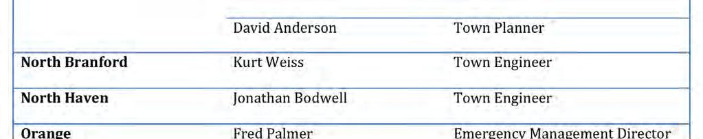

12 ADVISORY COMMITTEE


13 PUBLIC PARTICIPATION SURVEY IN THE MEDIA
14 PUBLIC SURVEY RESULTS 250 PARTICIPANTS! Participation Madison (38.5%) Branford (27.8%) Wallingford (10.7%) Hamden (9.8%) Demographics Most over age 30 70% college educated or higher 79% household income that exceeds $70,000 72% South Central Connecticut residence over 20 years 90% own their home, 90% are single family homes

15 CITIZEN PRIORITIES 91% report protecting critical facilities is most important
 Prevention")
16 COMMUNITY WIDE ACTIVITIES Emergency Services (91%) Public Education and Awareness (76%) Prevention (74%)

")
17 NOTED COMMENTS Natural Resources: Maintenance or removal of trees Dredging waterways Repairing seawalls Improving stormwater management systems Prevention: Improved zoning, planning and wetlands regulations Structural Projects: Removal of dams Elevation of structures Burying of power lines Public Education: Increase the amount and frequency of public education on disaster preparedness strategies Emergency Services: Improved methods of communications to citizens Better evacuation and post disaster planning (i.e. accessible information about shelter locations)

18 MUNICIPAL MEETINGS: COMMON THEMES Hazards Trees Too many along roadways, can block roads and take out power, can block neighborhoods and make travel to schools difficult Flooding Many places experience flooding during heavy rain or high tide Power Outages EOC s in Town Halls, Police Station or Fire Station depending on where generator is located Shelter capacity is limited
19 BRANFORD MUNICIPALITY MEETING SPECIFICS Branford is undergoing significant development around their highway exits and updating zoning and subdivision regulations as a part of the Town Master Plan. No grant writer on staff Triple A bond rating and good debt management plan Emergency Preparedness booklet distributed and website with good floodplain management information


20 RISK ASSESSMENT Helps establish mitigation priorities Key Steps Data Collection and Analysis Hazard Identification Hazard Profiles and Mapping Inventory of Community Assets Vulnerability Assessment


21 RISK ASSESSMENT APPROACH Quantitative Analysis Use of best available data and technology Deterministic and probabilistic modeling (Hazus MH and statistical methods) Qualitative Analysis Local knowledge and stakeholder collaboration Priority Risk Index

22 HAZARD IDENTIFICATION AND RESEARCH UPDATE: Severe Flooding Along Branford Shoreline Jenn McCulloch (Editor), September 2, 2011 A storm surge in Indian Neck has caused severe flooding with more than calf deep water stretching up many of the side roads. Check out these photos by Branford Patch Editor Nicole Ball to see how far the water has reached so far. Indian Neck Company 9 reported they responded to more than 30 calls from 3 a.m. until this afternoon. As the water receded, the State Highway Department was moving the sand from Route 146, by pay loader, back onto the beach in front of Waverly and Crouch roads. The local Public Works Department was clearing the local streets. Company 9 also reported a large section of Linden Avenue past Bayberry lane was completely destroyed in the surge. Over on 146, the Jersey barriers were lifted and placed across the street by the high tide, which coincided with the brunt of the storm. See photos for more details of the events. Branford Patch editor photo documenting the flooding in Indian Neck and beyond. No one was injured but authorities are urging residents to stay indoors as down powerlines can come back on and become very dangerous.

 $125 million in damages 40")
23 HISTORY OF HAZARD OCCURRENCES 453 events listed in NOAA Storm Events Database Hazard # of Events Property Damage Fatalities Injuries Flood 89 $3,210, Severe Thunderstorm 326 $1,340, Tornado 15 $129,825, Winter Storm 20 $123, Rip Current 2 $0 2 0 Tropical Storm 1 $0 1 0 Total 453 $134,498, tornado in Hamden (F4) $125 million in damages 40 injuries
24 HAZARD IDENTIFICATION Atmospheric Hydrologic Geologic Other Extreme Temperatures Coastal Erosion Earthquake Wildfire Hurricane/Tropical Storm Severe Thunderstorm Severe Winter Storm/ Nor easter Tornado Dam Failure Drought Flood Sea Level Rise * Climate change will be addressed in terms of its potential effects on the frequency and intensity of natural hazards.
25 HAZARD ANALYSIS Summary of Major Disaster and Emergency Declarations Hazard Profiles Description Brief descriptions of the hazard, its characteristics, and potential effects Location Geographic area within the planning area that are susceptible to occurrences of the hazard Extent Potential strength or magnitude of the hazard Previous Occurrences Brief summaries of notable occurrences Probability of Future Events Likelihood of future hazard occurrences in the planning area. * Includes any anticipated effects of climate change

26 PREVIOUS TORNADO OCCURRENCES

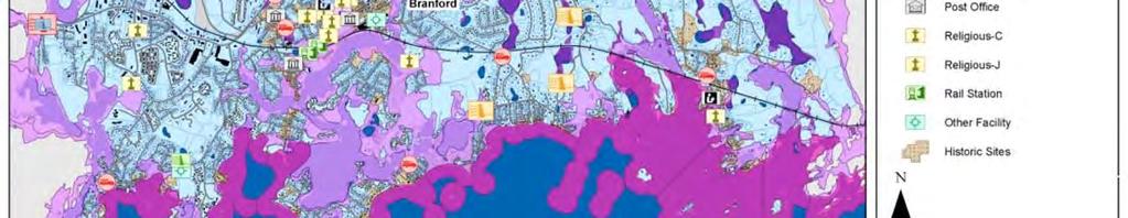
27 REGIONAL STORMSURGE INUNDATION AREAS

28 PEAK GROUND ACCELERATION & SIGNIFICANT EARTHQUAKE EPICENTERS
29 CRITICAL FACILITIES AND INFRASTRUCTURE Provide services essential for life safety and economic viability. Must continue to operate during and following a disaster. Critical Facilities High Potential Loss Facilities Infrastructure Systems Hospitals and medical facilities Police and fire stations Emergency operations centers Evacuation shelters Schools Airports/heliports Nuclear power plants Dams Military and civil defense installations Locations housing hazardous materials Water and wastewater Power utilities Transportation (roads, railways, waterways) Communication systems/centers Energy pipelines and storage


30 HAZUS MH FEMA S LOSS ESTIMATIONMETHODOLOGY Our Approach: Level 2 Analysis replace FEMA s national default inventory data with best available local data Results: Physical, economic and social impacts will be quantified for the South Central Region as well as each municipal jurisdiction

31 RISK ANALYSIS Main components for each participating jurisdiction Community assets Vulnerable assets Potential impacts Loss estimates Problem statements Methodologies used GIS based analysis Statistical analysis Hazus MH loss estimation Conclusions on hazard risk
32 POTENTIAL IMPACTS AND LOSS ESTIMATES Dollar value of at risk assets (total exposure) Parcels Critical facilities Historic assets Detailed loss estimates from Hazus MH (FEMA loss estimation methodology) Flood Hurricane wind Hurricane storm surge Earthquake Annualized losses
33 SEVERE WINTER STORM/NOR EASTER 21 historical events since 1996 No recorded fatalities $2.3 million in damages Heavy snowpack has resulted in multiple roof collapses Major impacts to electric utilities, transportation, and communications networks Coastal flooding associated with Nor easters PRI Category Location Probability Potential Impact Warning Time Duration Risk Level Large Highly Likely Critical More than 24 hours 1 to 7 days Anticipated effects of climate change: Shorter winters with fewer cold days and more precipitation (but less precipitation falling as snow and more as rain). Will result in reduced snowpack, earlier breakup of winter ice on lakes and rivers, and earlier spring snowmelt resulting in earlier peak river flows.


34 FLOOD HAZARD AREAS IN BRANFORD


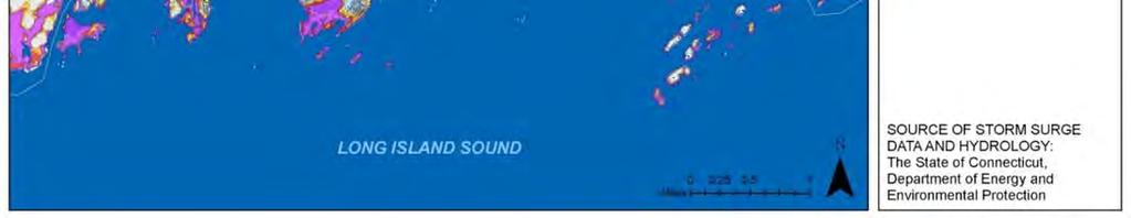
35 STORMSURGE AREA IN BRANFORD
 Warning time Duration of event Will be used in combination with vulnerability assessment results to identify most significant hazard risks Based on best available data, and YOUR")
36 PRIORITY RISK INDEX (PRI) Helps evaluate and prioritize hazards based on five factors: Location (geographic area affected) Probability of future events Impact (potential casualties, damage or loss) Warning time Duration of event Will be used in combination with vulnerability assessment results to identify most significant hazard risks Based on best available data, and YOUR input
37 FINAL PRI RESULTS HAZARD PRI Value Severe Winter Storm/Nor easter 3.3 Hurricane/Tropical Storm 3.2 Coastal Flood 3.0 Riverine Flood 2.8 Tornado 2.7 Coastal Erosion 2.7 Sea Level Rise 2.7 Extreme Temperatures 2.4 Severe Thunderstorm 2.4 Urban Flood 2.4 Wildfire 2.3 Dam Failure 2.2 Drought 2.2 Earthquake 2.2

38 HAZARDS OF CONCERN IN BRANFORD Tree related hazards Coastal flooding, coastal erosion, sea level rise Coastal and inland flooding of roadways Dam Failure in North Branford Lake Gaillard Dam failure would cause severe downstream flooding in Branford Moderate wildfire due to large amounts of open space, especially along railways New Haven Willie Mae Samuel shovels her driveway in Upper Westville as the rain fell causing foggy conditions. Photo Peter Casolino 2/11/13
39 AREAS OF CONCERN IN BRANFORD Flooding from poor drainage in low lying areas Hickory Road, Burban Drive, Tabor Drive, Beckett Ave., Meadow Street, Sunset Beach, Riverside Drive, Summer Island Road, Waverly Park Area, Thimble Island Road, Shore Drive, Limewood Ave., Island View Avenue, Club Parkway, School Ground Road Linden Avenue concern for coastal flooding and erosion because existing revetment has been repeatedly damaged and repaired 100 homes located on offshore islands

40 VULNERABLE COMMUNITYASSETS IN BRANFORD Water Treatment Plant can become isolated from flooding Numerous pump stations without backup generators Shelters located in storm surge inundation areas CT Hospice at Double Beach Road no storm shutters on large windows, no backup generator Commercial Street and Route 139 vulnerable to Branford River flooding
41 MITIGATION TECHNIQUES 1. Prevention Typically government programs building codes, floodplain regulations 2. Property Protection Modification of buildings, building elevation, seismic retrofit 3. Natural Resource Protection Protect natural resources, land acquisition, floodplain protection 4. Structural Projects Modify environment with construction, dams, storm sewers, beach nourishment 5. Emergency Services Warning systems, sandbagging, evacuation planning 6. Public Education and Awareness Outreach projects, hazard mapping, real estate disclosure
42 MITIGATION ACTIONS SPECIFIC TO BRANFORD 1. Linden Avenue Erosion Protection Project Identify and construct erosion protection 2. Generators for Town Buildings Stand by generators for 2 shelters, EOC/Police Station, Volunteer Services Center, and Wastewater Treatment Plant 3. Meadow Street and Indian Neck Avenue Flood Protection Project Protect LL&P substation and improve access during floods 4. Hotchkiss Structural Mitigation Project Raise electronics at Hotchkiss Sewage Pumping Station 5. Hazards Planning & Public Health Preparedness Project Promote awareness regarding preparedness and mitigation


43 FLOODPLAIN MAPPING TOOLKIT New Resources for Public Education Fact Sheet PowerPoint Presentation Non technical Information About the NFIP FEMA floodplain maps Floodplain mapping process Risk MAP Procedures for map changes Target audience Property owners To be distributed or delivered by local community officials


44 PLAN MAINTENANCE PROCESS Develop a plan to update and maintain the mitigation plan on a regular basis. Required to update it every 5 years for State and FEMA review. Include a plan to implement the mitigation plan strategy.
45 PLAN ADOPTION AND APPROVAL All SCRCOG participating jurisdictions will formally adopt the plan. SCRCOG will formally adopt the plan. CT Department of Energy and Environmental Protection (CT DEEP) will review and approve the plan. FEMA will review and approve the plan. Draft plan available for review and feedback on the website in several months.
 617 371 4547 Cell) 413 218 7310 jamie@jamiecaplan.")
46 THANK YOU Jamie Caplan Contact: Jamie Caplan, Project Manager Jamie Caplan Consulting, LLC Office) Cell)
REGIONAL HAZARD MITIGATION PLANNING IN SOUTH CENTRAL CONNECTICUT. Association of State Floodplain Managers Conference June 13, 2013 Hartford, CT
 REGIONAL HAZARD MITIGATION PLANNING IN SOUTH CENTRAL CONNECTICUT Association of State Floodplain Managers Conference June 13, 2013 Hartford, CT MULTI-JURISDICTION MITIGATION PLAN South Central Regional
Advisory Committee Meeting December 5, 2012
 SOUTH CENTRAL REGION MULTI-JURISDICTION HAZARD MITIGATION PLAN Advisory Committee Meeting December 5, 2012 MEETING PURPOSE Review Municipality Meetings and Capabilities Review Hazard Identification and
Page G Crow Wing County Multi-Hazard Mitigation Plan, 2017
 Table G - 10. s Identified by the () (From Crow Wing County Master Chart) 1 5 All- Hazards All- Hazards Work to ensure that all Crow Wing County residents are aware of and sign-up for the County s Emergency
Table G - 6. Mitigation Actions Identified for Implementation by the City of Kent ( ) (From Wilkin County Master Mitigation Action Chart)
 (From Wilkin County Master Mitigation Action Chart)") Table G - 6. Actions Identified by the () (From Master Action Chart) Multi-Hazard Plan, 2017 Action Comments 5 All-Hazards Local Planning & Regulations Update the Operations Plan on an annual basis. Work
Table G - 6. Actions Identified by the () (From Master Action Chart) Multi-Hazard Plan, 2017 Action Comments 5 All-Hazards Local Planning & Regulations Update the Operations Plan on an annual basis. Work
Timeframe. Crow Wing County, Baxter, Brainerd, Breezy Point, Crosby, Crosslake, Cuyuna, Deerwood, Emily, Fifty
 Table G - 13. s Identified for by the () (From Crow Wing County Master Chart) 1 5 9 All- Hazards All- Hazards Winter Work to ensure that all Crow Wing County residents are aware of and sign-up for the
Pre-Disaster Natural Hazard Mitigation Plan Guilford, Connecticut History of Hazard Mitigation Planning Authority Disaster Mitigation Act of 2000 (ame
 Pre-Disaster Natural Hazard Mitigation Plan Guilford, Connecticut History of Hazard Mitigation Planning Authority Disaster Mitigation Act of 2000 (amendments to Stafford Act of 1988) Presented by: David
West Carroll Parish Hazard Mitigation Plan Update Public Meeting. August 25, 2015 Oak Grove, LA
 West Carroll Parish Hazard Mitigation Plan Update Public Meeting August 25, 2015 Oak Grove, LA Agenda Hazard Mitigation Planning Process SDMI Staff Risk Assessment SDMI Staff Update on Previous/Current
Baldwin County, Alabama
 2015 Baldwin County, Alabama Multi-Hazard Mitigation Plan I. Comprehensive Plan A multi-jurisdiction plan City of Bay Minette City of Daphne Town of Elberta City of Fairhope City of Foley City of Gulf
Assumption Parish Hazard Mitigation Plan Update Public Meeting. September 1, 2015 Napoleonville, LA
 Assumption Parish Hazard Mitigation Plan Update Public Meeting September 1, 2015 Napoleonville, LA Agenda Hazard Mitigation Planning Process SDMI Staff Risk Assessment SDMI Staff Update on Previous/Current
Bossier Parish Hazard Mitigation Plan Update Public Meeting. August 10, 2016 Bossier City, LA
 Bossier Parish Hazard Mitigation Plan Update Public Meeting August 10, 2016 Bossier City, LA Agenda Hazard Mitigation Planning Process SDMI Staff Risk Assessment SDMI Staff Update on Previous/Current Mitigation
5.2. IDENTIFICATION OF NATURAL HAZARDS OF CONCERN
 5.2. IDENTIFICATION OF NATURAL HAZARDS OF CONCERN To provide a strong foundation for mitigation strategies considered in Sections 6 and 9, County considered a full range of natural hazards that could impact
West Baton Rouge Parish Hazard Mitigation Plan Update Public Meeting. September 9, 2015 Port Allen, LA
 West Baton Rouge Parish Hazard Mitigation Plan Update Public Meeting September 9, 2015 Port Allen, LA Agenda Hazard Mitigation Planning Process SDMI Staff Risk Assessment SDMI Staff Update on Previous/Current
5.2 IDENTIFICATION OF HAZARDS OF CONCERN
 5.2 IDENTIFICATION OF HAZARDS OF CONCERN 2016 HMP Update Changes The 2011 HMP hazard identification was presented in Section 3. For the 2016 HMP update, the hazard identification is presented in subsection
Southington. Challenges
 Southington Southington, similar to its next-door neighbor Berlin, is a suburban community in the southeast part of the region. Originally an agricultural community, Southington has also hosted industry
5.2 IDENTIFICATION OF HAZARDS OF CONCERN
 5.2 IDENTIFICATION OF HAZARDS OF CONCERN 2015 HMP Update Changes The 2010 HMP hazard identification was presented in Section 6. For the 2015 HMP update, the hazard identification is presented in subsection
IDENTIFICATION OF HAZARDS OF CONCERN
 IDENTIFICATION OF HAZARDS OF CONCERN To provide a strong foundation for mitigation strategies considered in Section 6, the Village considered a full range of hazards that could impact the area and then
Extreme Weather and Risks to Infrastructure. Heather Auld & Neil Comer Risk Sciences International
 Extreme Weather and Risks to Infrastructure Heather Auld & Neil Comer Risk Sciences International The Science is Valid and the Evidence grows Stronger AGREE Climate Change Disagree More Intense Rainfall
Earthquakes. & Expansive Soils
 Earthquakes & Expansive Soils January 22, 2009 Plan Update Flanagan & Associates, LLC Consultants Tulsa, OK www.rdflanagan.com rdflanagan@rdflanagan.com Plan can be reviewed at: www.rdflanagan.com/.html
5.2 IDENTIFICATION OF HAZARDS OF CONCERN
 5.2 IDENTIFICATION OF HAZARDS OF CONCERN 2016 HMP Update Changes The 2011 HMP hazard identification was presented in Section 3. For the 2016 HMP update, the hazard identification is presented in subsection
Oregon APA Legal Issues Workshop December 7, Tricia Sears, DLCD With information from Bill Burns, DOGAMI
 Oregon APA Legal Issues Workshop December 7, 2018 Tricia Sears, DLCD With information from Bill Burns, DOGAMI How this Topic Arrived WE FREQUENTLY HEAR CONCERNS ABOUT LIABILITY AND TAKINGS. Current federal
2014 Annual Mitigation Plan Review Meeting
 2014 Annual Mitigation Plan Review Meeting Highland County EMA MEETING OBJECTIVES Understand Your Natural Disaster Risk Review of Previous Plans Current Plan Status Future Activity Plan/Needs of Each Community
B.2 Sources for Hazard Identification, Profiling, and Ranking (Section 3) Overview of Sussex County s History of Hazards
 Overview of Sussex County s History of Hazards") Appendix B Sources B.1 Sources for Planning Process (Section 2) FEMA. Mitigation Planning Guidance (386 Series). Available on the web at: http://www.fema.gov/plan/mitplanning/planning_resources.shtm FEMA
Appendix B Sources B.1 Sources for Planning Process (Section 2) FEMA. Mitigation Planning Guidance (386 Series). Available on the web at: http://www.fema.gov/plan/mitplanning/planning_resources.shtm FEMA
Miami-Dade County Overview
 Miami-Dade County Overview 2,000 square miles World s busiest cruise port 2.6 million residents Second busiest US airport for international travelers Gateway to the Caribbean and Latin America Natural
From Vulnerability to Resilience And the Tools to Get There. Out of Harm s Way Partnership for the Delaware Estuary August 1, 2012
 From Vulnerability to Resilience And the Tools to Get There Out of Harm s Way Partnership for the Delaware Estuary August 1, 2012 Today s Presentation Tour of New Jersey Challenges Definitions so we re
Joseph E. Boxhorn, Ph.D., Senior Planner Southeastern Wisconsin Regional Planning Commission #
 Joseph E. Boxhorn, Ph.D., Senior Planner Southeastern Wisconsin Regional Planning Commission # 228395 Chapter I Introduction and Background Chapter II Basic Study Area Inventory and Analysis Hazard
Draft for Discussion 11/11/2016
 Coastal Risk Consulting (CRC) Climate Vulnerability Assessment for Village of Key Biscayne Deliverable 1.1 in Statement of Work. Preliminary Vulnerability Assessment Identifying Flood Hotspots Introduction...
City of Manitou Springs
 March 2018 City of Manitou Springs Implementing Land Use tools to reduce and mitigate natural hazard risk Context & History Past Present Historic homes Older infrastructure Hillside development Creekside
SECTION 6 VULNERABILITY ASSESSMENT
 SECTION 6 VULNERABILITY ASSESSMENT This section identifies and quantifies the vulnerability of the MEMA District 1 Region to the significant hazards identified in the previous sections (Hazard Identification
CITY OF TUSCALOOSA ORGANIZATION OF 2015 FMP FLOODPLAIN MANAGEMENT PLAN
 CITY OF TUSCALOOSA FLOODPLAIN MANAGEMENT PLAN FMPC Meeting #2 July 8, 2015 ORGANIZATION OF 2015 FMP 2015 Floodplain Management Plan Structure Chapter 1 Introduction Chapter 2 Community Profile Chapter
5.2 IDENTIFICATION OF HAZARDS OF CONCERN
 5.2 IDENTIFICATION OF HAZARDS OF CONCERN To provide a strong foundation for mitigation actions considered in Sections 6 and 9, County focused on considering a full range of s that could impact area, and
STEUBEN COUNTY, NEW YORK. Hazard Analysis Report
 STEUBEN COUNTY, NEW YORK Hazard Analysis Report Prepared by: April 1, 2014 Background On April 1, 2014 the Steuben County Office of Emergency Management conducted a hazard analysis using the automated
RISK ASSESSMENT COMMUNITY PROFILE NATURAL HAZARDS COMMUNITY RISK PROFILES. Page 13 of 524
 RISK ASSESSMENT COMMUNITY PROFILE NATURAL HAZARDS COMMUNITY RISK PROFILES Page 13 of 524 Introduction The Risk Assessment identifies and characterizes Tillamook County s natural hazards and describes how
4.1 Hazard Identification: Natural Hazards
 data is provided in an annex, it should be assumed that the risk and potential impacts to the affected jurisdiction are similar to those described here for the entire Sacramento County Planning Area. This
KENTUCKY HAZARD MITIGATION PLAN RISK ASSESSMENT
 KENTUCKY HAZARD MITIGATION PLAN RISK ASSESSMENT Presentation Outline Development of the 2013 State Hazard Mitigation Plan Risk Assessment Determining risk assessment scale Census Data Aggregation Levels
Hurricane Readiness for Coastal Communities
 Hurricane Readiness for Participant Guide Developed for: Federal Emergency Management Agency Emergency Management Institute 16825 South Seton Avenue Emmitsburg, MD 21727-8998 Developed by: C² Technologies,
City of Madison Flooding Event AUGUST 20 TH, 2018-PRESENT
 City of Madison Flooding Event AUGUST 20 TH, 2018-PRESENT Presentation Overview Review of Flash Flooding and Flooding from High Lake Levels (August 20 th -Present) Lake Level Information Damages FEMA How
AHEAD OF THE STORM: Extreme Weather Resilience in the City of Toronto
 AHEAD OF THE STORM: Extreme Weather Resilience in the City of Toronto David MacLeod Toronto Environment and Energy Office Environmental Applied Science and Management Symposium 2013 March 21, 2013 Ahead
Table-Top Exercise for Emergency Preparedness Evaluation: Little Anse, Isle Madame
 Table-Top Exercise for Emergency Preparedness Evaluation: Little Anse, Isle Madame Alexander Chung, M.Sc. Candidate C-Change Student Research Associate May 2013 The Community of Little Anse Coastal community
Chippewa County Natural Hazards Mitigation Plan
 2014 Chippewa County Natural Hazards Mitigation Plan Prepared for: Chippewa County Office of Emergency Management With the Assistance of: Eastern U.P. Regional Planning & Development Commission April,
4.4 Assessing Vulnerability: Estimating Potential Losses
 4.4 Assessing Vulnerability: Estimating Potential Losses This section presents exposure, damage, and loss estimates, for each of the 8 hazards evaluated. The findings support planning efforts based on
HAZARD IDENTIFICATION... 1 HAZARD EFFECTS OF CLIMATE CHANGE... 2 OVERVIEW OF HAZARD ANALYSIS... 4 BUILDING VALUES... 5 POTENTIAL DOLLAR LOSSES...
 R ISK OVERVIEW IDENTIFICATION... 1 EFFECTS OF CLIMATE CHANGE... 2 OVERVIEW OF ANALYSIS... 4 BUILDING VALUES... 5 POTENTIAL DOLLAR LOSSES... 7 IDENTIFICATION This section begins the risk assessment, which
2014 Russell County Hazard Mitigation Plan Update STAKEHOLDERS AND TECHNICAL ADVISORS MEETING 2/6/14
 2014 Russell County Hazard Mitigation Plan Update STAKEHOLDERS AND TECHNICAL ADVISORS MEETING 2/6/14 Welcome and Introductions We cannot direct the wind, but we can adjust our sails. 44 CFR 201.6; Local
Municipal Mitigation Goals, Objectives, and Strategies
 Municipal Mitigation Goals, Objectives, and Strategies While the risks from natural hazards confronting the seven municipalities of Central Connecticut may be largely similar, priorities, concerns, economic
APPLICATIONS OF EARTHQUAKE HAZARD MAPS TO LAND-USE AND EMERGENCY PLANNING EXAMPLES FROM THE PORTLAND AREA
 APPLICATIONS OF EARTHQUAKE HAZARD MAPS TO LAND-USE AND EMERGENCY PLANNING EXAMPLES FROM THE PORTLAND AREA O. Gerald Uba Metro, Portland, Oregon OVERVIEW The extent to which we understand "below ground"
Joseph E. Boxhorn, Ph.D., Senior Planner Southeastern Wisconsin Regional Planning Commission #
 Joseph E. Boxhorn, Ph.D., Senior Planner Southeastern Wisconsin Regional Planning Commission # 228346 Chapter I Introduction and Background Chapter II Basic Study Area Inventory and Analysis Hazard
HAZUS-MH: Earthquake Event Report
 HAZUS-MH: Earthquake Event Report Region Name: El Paso County Earthquake Scenario: El Paso County Random EQ Print Date: February 08, 2006 Disclaimer: The estimates of social and economic impacts contained
Proposed Scope of Work Village of Farmingdale Downtown Farmingdale BOA Step 2 BOA Nomination Study / Draft Generic Environmental Impact Statement
 Proposed Scope of Work Village of Farmingdale Downtown Farmingdale BOA Step 2 BOA Nomination Study / Draft Generic Environmental Impact Statement The scope of work that follows incorporates and covers
Pacific Catastrophe Risk Assessment And Financing Initiative
 Pacific Catastrophe Risk Assessment And Financing Initiative TIMOR-LESTE September Timor-Leste is expected to incur, on average, 5.9 million USD per year in losses due to earthquakes and tropical cyclones.
HAZARD DESCRIPTION... 1 LOCATION... 1 EXTENT... 1 HISTORICAL OCCURRENCES...
 WINTER STORM HAZARD DESCRIPTION... 1 LOCATION... 1 EXTENT... 1 HISTORICAL OCCURRENCES... 3 SIGNIFICANT PAST EVENTS... 4 PROBABILITY OF FUTURE EVENTS... 5 VULNERABILITY AND IMPACT... 5 Hazard Description
Florida Flood Risks. Heavy Rainfall. Groundwater. Tidal Flooding. Storm Surge. King Tides. Runoff/Riverine
 Florida Flood Risks Heavy Rainfall Storm Surge Groundwater Tidal Flooding Runoff/Riverine King Tides Sawgrass Mills Mall Sunrise, Florida 15 of rain in 3 days, with most in 24 hours. Mall closed for 3
Coastal Resiliency: Planning for Natural Variability and Recovering from Extreme Events
 Coastal Resiliency: Planning for Natural Variability and Recovering from Extreme Events Stephanie Showalter, J.D., M.S.E.L. Director, National Sea Grant Law Center University of Mississippi Coastal Hazards
PW 001 SNOW REMOVAL AND SANDING FOR ROADWAYS AND SIDEWALKS October 6, 2014 (#223-14) Original October 19, 2015; October 15, 2018 Public Works
 Original October 19, 2015; October 15, 2018 Public Works") Policy Statement: The Village of Kitscoty will provide snow and ice control on municipal streets and sidewalks according to determined priorities. Purpose: To provide direction and information to employees
Policy Statement: The Village of Kitscoty will provide snow and ice control on municipal streets and sidewalks according to determined priorities. Purpose: To provide direction and information to employees
On Page 1, following Paragraph 2 of the Planning Participants subsection, insert the following: 2012 Committee members included:
 Appendix 4: City of West Linn Addendum to the Clackamas County Natural Hazards Mitigation Plan 2012 Amendments and Update The Oregon Partnership for Disaster Resilience prepared this Appendix to the City
5.2 IDENTIFICATION OF NATURAL HAZARDS OF CONCERN
 5.2 IDENTIFICATION OF NATURAL HAZARDS OF CONCERN To provide a strong foundation for mitigation strategies considered in Sections 6 and 9, County considered a full range of natural s that could impact area,
Summary of Available Datasets that are Relevant to Flood Risk Characterization
 Inter-Agency Characterization Workshop February 25-27, 2014 USACE Institute for Water Resources, Alexandria, VA, IWR Classroom Summary of Available Datasets that are Relevant to Characterization National
Table 31. Steele County Master Mitigation Action Chart ( )
") Table 31. Master Action Chart () Action Comments on Planning 1 All-Hazards 2 All-Hazards Education & Awareness Programs Work to ensure that all residents are aware of and sign-up for the Everbridge emergency
Table 31. Master Action Chart () Action Comments on Planning 1 All-Hazards 2 All-Hazards Education & Awareness Programs Work to ensure that all residents are aware of and sign-up for the Everbridge emergency
Doug Kluck NOAA Kansas City, MO National Center for Environmental Information (NCEI) National Integrated Drought Information System (NIDIS)
 National Integrated Drought Information System (NIDIS)") National Integrated Drought Information System (NIDIS) for the Missouri River Basin Drought Early Warning Information System (DEWS) & Runoff Trends in the Missouri Basin & Latest Flood Outlook Doug Kluck
National Integrated Drought Information System (NIDIS) for the Missouri River Basin Drought Early Warning Information System (DEWS) & Runoff Trends in the Missouri Basin & Latest Flood Outlook Doug Kluck
Residents Emergency Response Checklist
 COMMUNITY RESILIENCE PLAN Residents Emergency Response Checklist A helpful guide in the event of extreme weather or bushfire events. < PREVIOUS I NEXT > 02 Purchasing an existing property or building a
Appendix F Public Outreach & Engagement Documentation
 Appendix F Public Outreach & Engagement Documentation Page F - 1 Page F - 2 Page F - 3 Page F - 4 Page F - 5 Page F - 6 Page F - 7 Page F - 8 Page F - 9 Page F - 10 Page F - 11 Page F - 12 https://scse.d.umn.edu/steele-county-mhmp
Hurricane Matthew Threats and Impacts Briefing for Eastern NC
 Hurricane Matthew Threats and Impacts Briefing for Eastern NC October 6 th, 2016 Date/Time Created: 10/6/2016, Noon EDT National Weather Service Newport/Morehead City, NC Hurricane Matthew Key Points Changes
A HURRICANE IS COMING. Presented by Atiba Upchurch Broward Emergency Management Division
 A HURRICANE IS COMING Presented by Atiba Upchurch Broward Emergency Management Division Mission Statement To safeguard the lives and property of the people of Broward County from major hazards and emergencies
Appendix C Fluvial Flood Hazards
 Appendix C Fluvial Flood Hazards Sea Level Rise Vulnerability Assessment and Adaptation Project March 2019 Contents Contents... i Figures... i Tables... i Definitions, Acronyms, & Abbreviations... ii
Hazard Vulnerability Analysis (HVA)
") Hazard Vulnerability Analysis (HVA) What is an HVA Systematic approach to recognizing hazards that may effect the ability to care for residents The risks associated with each hazard are analyzed to prioritize
Hazard Vulnerability Analysis (HVA) What is an HVA Systematic approach to recognizing hazards that may effect the ability to care for residents The risks associated with each hazard are analyzed to prioritize
Randall W. Parkinson, Ph.D., P.G. Institute of Water and Environment Florida International University
 An Update on Adaptation Action Activities Undertaken Since Completion of the City of Satellite Beach (FL) Vulnerability Assessment to Rising Seas (2010) Randall W. Parkinson, Ph.D., P.G. Institute of Water
Assessing Hazards and Risk
 Page 1 of 6 EENS 204 Tulane University Natural Disasters Prof. Stephen A. Nelson Assessing Hazards and Risk This page last updated on 07-Jan-2004 As discussed before, natural disasters are produced by
Adapting to Climate Change in Black River First Nation
 Adapting to Climate Change in Black River First Nation Dr. Brian G. Kotak, General Manager -Manitoba Model Forest Jack Johnson, Special Projects Black River First Nation Climate Change & Health Adaptation
Running Head: HAZARD MITIGATION PLAN OUTLINE FOR MISSISSIPPI 1
 Running Head: HAZARD MITIGATION PLAN OUTLINE FOR MISSISSIPPI 1 Hazard Mitigation Plan Outline for Mississippi Name: Institution: HAZARD MITIGATION PLAN OUTLINE FOR MISSISSIPPI 2 Hazard Mitigation Plan
SECTION IV ASSESSING VULNERABILITY AND RISK
 SECTION IV ASSESSING VULNERABILITY AND RISK Describing vulnerability in terms of potential dollar loss provides the local government, the State and the federal government with a common framework with which
CITY OF VESTAVIA HILLS
 CITY OF VESTAVIA HILLS FLOODPLAIN MANAGEMENT PLAN FMPC Meeting #3 September 29, 2015 ORGANIZATION OF 2015 FMP 2015 Floodplain Management Plan Structure Chapter 1 Introduction Chapter 2 Community Profile
CLIMATE READY BOSTON. Climate Projections Consensus ADAPTED FROM THE BOSTON RESEARCH ADVISORY GROUP REPORT MAY 2016
 CLIMATE READY BOSTON Sasaki Steering Committee Meeting, March 28 nd, 2016 Climate Projections Consensus ADAPTED FROM THE BOSTON RESEARCH ADVISORY GROUP REPORT MAY 2016 WHAT S IN STORE FOR BOSTON S CLIMATE?
What the Science Tells Us & How Practitioners Can Use the Science
 What the Science Tells Us & How Practitioners Can Use the Science Presented at APTA Los Angeles, CA Presented by Dr. B. Tod Delaney President, First Environment, Inc. Wed. August 3, 2011 1 Agenda 1. What
New Jersey Department of Transportation Extreme Weather Asset Management Pilot Study
 New Jersey Department of Transportation Extreme Weather Asset Management Pilot Study Overview Prepared for: June 26, 2018 Introduction Overview of Pilot Study New Jersey s Climate New Jersey s Transportation
Pacific Catastrophe Risk Assessment And Financing Initiative
 Pacific Catastrophe Risk Assessment And Financing Initiative PALAU September is expected to incur, on average,.7 million USD per year in losses due to earthquakes and tropical cyclones. In the next 5 years,
Weather Information for Surface Transportation (WIST): Update on Weather Impacts and WIST Progress
: Update on Weather Impacts and WIST Progress") Weather Information for Surface Transportation (WIST): Update on Weather Impacts and WIST Progress Samuel P. Williamson Office of the Federal Coordinator for Meteorological Services and Supporting Research
Weather Information for Surface Transportation (WIST): Update on Weather Impacts and WIST Progress Samuel P. Williamson Office of the Federal Coordinator for Meteorological Services and Supporting Research
PUBLIC SAFETY POWER SHUTOFF POLICIES AND PROCEDURES
 PACIFIC GAS AND ELECTRIC COMPANY PUBLIC SAFETY POWER SHUTOFF POLICIES AND PROCEDURES SEPTEMBER 2018 1 PACIFIC GAS AND ELECTRIC COMPANY PUBLIC SAFETY POWER SHUTOFF POLICIES AND PROCEDURES SEPTEMBER 2018
Pacific Catastrophe Risk Assessment And Financing Initiative
 Pacific Catastrophe Risk Assessment And Financing Initiative VANUATU September 211 Country Risk Profile: VANUATU is expected to incur, on average, 48 million USD per year in losses due to earthquakes and
3.1: Identifying Hazards. Introduction
 3.1: Identifying Hazards 44 CFR 201.4(c)(5)(i)(ii) The State mitigation strategy shall include the following elements: A Plan Maintenance Process that includes: An established method and schedule for monitoring,
National Weather Service 1
 National Weather Service 1 National Weather Service Source: FEMA 2 The Need for a Robust/Diverse Severe Weather Plan Presidential Disaster Declarations 2015 Kentucky Disaster Declarations DR-4216 (Feb
COMMUNITY EMERGENCY RESPONSE TEAM FLOODS INTRODUCTION
 INTRODUCTION Floods are one of the most common hazards in the United States. A flood occurs any time a body of water rises to cover what is usually dry land. Flood effects can be local, impacting a neighborhood
1 City of Edmonton Quesnell Bridge, Roads and Associated Structures Assessment
 1 City of Edmonton Quesnell Bridge, Roads and Associated Structures Assessment 1.1 Background Within the First National Engineering Vulnerability Assessment, the Public Infrastructure Engineering Vulnerability
Application #: TEXT
 TOWN OF FORT MYERS BEACH 2008 PROPOSED COMPREHENSIVE PLAN AMENDMENTS Application #: 2008-13-TEXT Description: Modify the Coastal Management and Future Land Use Elements to reflect the state s new definition
SEVERE WEATHER 101. Flood Basics
 SEVERE WEATHER 101 Flood Basics What is flooding? Flooding is an overflowing of water onto land that is normally dry. Floods can happen during heavy rains, when ocean waves come on shore, when snow melts
WINTER STORM Annex II
 WINTER STORM Annex II I. PURPOSE A. This annex has been prepared to ensure a coordinated response by state agencies to requests from local jurisdictions to reduce potential loss of life and to ensure essential
They include earthquakes, volcanic eruptions, floods, landslides, and other processes and occurrences. They are included in the broader concept of.
 They include earthquakes, volcanic eruptions, floods, landslides, and other processes and occurrences. They are included in the broader concept of. In general, natural processes are labeled hazardous only
While all thunderstorms are dangerous, the National Weather Service (NWS) defines a severe thunderstorm as one that:
 defines a severe thunderstorm as one that:") While all thunderstorms are dangerous, the National Weather Service (NWS) defines a severe thunderstorm as one that: Produces hail at least three-quarters of an inch in diameter. Has winds of 58 miles
While all thunderstorms are dangerous, the National Weather Service (NWS) defines a severe thunderstorm as one that: Produces hail at least three-quarters of an inch in diameter. Has winds of 58 miles
Hurricanes and coastal storms pose a risk because powerful winds and storm surges can:
 HURRICANES A hurricane is a violent area of low pressure forming in the tropical Atlantic Ocean from June to November. August and September are peak months. (Similar Western Pacific Ocean storms are called
Wainui Beach Management Strategy (WBMS) Summary of Existing Documents. GNS Tsunami Reports
 Summary of Existing Documents. GNS Tsunami Reports") Wainui Beach Management Strategy (WBMS) Summary of Existing Documents GNS Tsunami Reports a) Review of Tsunami Hazard and Risk in New Zealand ( National Risk Report ) b) Review of New Zealand s Preparedness
Wainui Beach Management Strategy (WBMS) Summary of Existing Documents GNS Tsunami Reports a) Review of Tsunami Hazard and Risk in New Zealand ( National Risk Report ) b) Review of New Zealand s Preparedness
Massachusetts Department of Public Health Emergency Preparedness Bureau. August 27, hrs
 Massachusetts Department of Public Health Emergency Preparedness Bureau August 27, 2011 1500 hrs Health and Medical Situational Awareness Report: Hurricane Irene Situational Awareness Report: Hurricane
Sea-Level Rise Impacts on South Florida
 Sea-Level Rise Impacts on South Florida Keren Prize Bolter, PhD Science Director, Coastal Risk Consulting. LLC 5/3/16 FAQ list What is happening? What impacts are we already seeing? Just how vulnerable
Flood Scenario Worksheet
 Flood Scenario Worksheet Scenario adapted from: http://www.epa.gov/watersecurity/tools/trainingcd/simple/source/scenario-8/ssc8-0.pdf Simple Tabletop Exercise, Interdependency Natural Disaster Scenario,
The Tampa Bay Catastrophic Plan Presentation to CFGIS Users Group FDOT District 5 Urban Offices - Orlando July 30, 2010
 The Tampa Bay Catastrophic Plan Presentation to CFGIS Users Group FDOT District 5 Urban Offices - Orlando July 30, 2010 Brady Smith Senior Planner Tampa Bay Regional Planning Council Introduction Recent
Natural Disasters. in Florida. Severe Thunderstorms
 Natural Disasters in Florida SC.6.E.7.7 Investigate how natural disasters have affected human life in Florida. Severe Thunderstorms While the typical afternoon thunderstorm in Florida may not appear to
Vulnerability of Bangladesh to Cyclones in a Changing Climate
 Vulnerability of Bangladesh to Cyclones in a Changing Climate Susmita Dasgupta Kiran Pandey Mainul Huq Zahirul Huq Khan M.M. Zahid Ahmed Nandan Mukherjee Malik Fida Khan 2010 Bangladesh: Tropical Cyclone
Risk Assessment and Mitigation. Hurricane Checklist
 Risk Assessment and Mitigation Hurricane Checklist Hurricane Checklist Hurricanes are severe tropical storms with sustained winds of at least 74 miles per hour. Hurricane winds can reach 160 miles per
HURRICANE MATTHEW A GIS PERSPECTIVE GLYNN COUNTY GIS
 HURRICANE MATTHEW A GIS PERSPECTIVE GLYNN COUNTY GIS Situation September 25 th October 9 th 2016 Hurricane Matthew tracked its way up the east coast bringing hurricane force winds and flooding from Haiti
KNOWLEDGE NOTE 5-1. Risk Assessment and Hazard Mapping. CLUSTER 5: Hazard and Risk Information and Decision Making. Public Disclosure Authorized
 Public Disclosure Authorized Public Disclosure Authorized Public Disclosure Authorized Public Disclosure Authorized KNOWLEDGE NOTE 5-1 CLUSTER 5: Hazard and Risk Information and Decision Making Risk Assessment
THE NEED FOR AN ADDITIONAL SPILLWAY AT THE SANFORD DAM BOILING SPRING LAKES, NC. Presentation for The Brunswick County Commissioners April 20, 2015
 THE NEED FOR AN ADDITIONAL SPILLWAY AT THE SANFORD DAM BOILING SPRING LAKES, NC Presentation for The Brunswick County Commissioners April 20, 2015 The Sanford Dam Earth Dam constructed in 1961 Drainage
Disaster Risk Assessment: Opportunities for GIS and data management with Open DRI
 Disaster Risk Assessment: Opportunities for GIS and data management with Open DRI Jacob Opadeyi Department of Geomatics Engineering and Land Management, The University of the West Indies, St. Augustine,
TORNADOES. DISPLAY VISUAL A Tornado Is... Tornadoes can: Rip trees apart. Destroy buildings. Uproot structures and objects.
 TORNADOES Introduce tornadoes by explaining what a tornado is. DISPLAY VISUAL A Tornado Is... A powerful, circular windstorm that may be accompanied by winds in excess of 250 miles per hour. Tell the participants
Floods. Floods COMMUNITY EMERGENCY RESPONSE TEAM FLOODS CONTENT INSTRUCTOR GUIDANCE
 Floods Floods Introduce this topic by explaining that floods are one of the most common hazards in the United States. A flood occurs any time a body of water rises to cover what is usually dry land. Display