Neeraj Kaushal 1, Kamal Kumar 2 Water Resources Department, PEC University of Technology, Chandigarh, India. IJRASET 2013: All Rights are Reserved
|
|
|
- Bryce Nicholson
- 5 years ago
- Views:
Transcription
1 Time Series Analysis of Glacial Lake in Western Himalayas Based on NDWI and MNDWI Neeraj Kaushal 1, Kamal Kumar 2 Water Resources Department, PEC University of Technology, Chandigarh, India Abstract This Water always appears diversely, which makes its extraction not so simple. In this paper, we propose a new, simple, fast and accurate methodology based on a combination of the two indices NDWI and MNDWI for calculating lake area and analyzing the change using Landsat data. The water indices are designed to highlight inland water bodies in remotely sensed imagery. The water information by NDWI always mixed with built-up land noise and thus the area of a water body was overestimated. MNDWI could significantly highlight the water information, as it can easily distinguish shadow and water body and solve the problem to eliminate shadow in extracting water information. The application of these indices for water body mapping is mainly based on the thresholding method to separate water from non water areas especially in the context of determining the lake area.. A subpixel approach is then applied to the eliminate the problems of mixes pixels to enhance the results. Keywords Remote Sensing, Glacial Lakes, Water Indices, NDWI, MNDWI I. INTRODUCTION The average surface temperature on the Earth s surface have been continuously increasing since the end of the Ice Age and has increased between 0.3ºC to 0.6ºC over the past hundred years [1]. This continuous change in temperature has lead to various changes in the Earth s glaciological environment. Basically the melting of glacial ice has also been found to increase quite rapidly since the modern men have started to pollute the natural resources abundantly and frequently. This ice melt results in the formation of large number of high altitude glacial lakes which can cause real big problems if not countered. Generally a Glacial lake is defined as water mass existing in a sufficient amount and extending with a free surface in, under, beside, and/or in front of a glacier and originating from glacier activities and/or retreating processes of a glacier [2]. Outside the polar region, the Himalayas have the largest concentration of glaciers. Most of the Himalayan glaciers have retreated in recent past, leaving behind large number of glacial lakes. The Himalayan region itself contains hundreds of lakes varying from low elevation to the high elevation. Out of these many of the lakes of Himalaya are fresh water lakes, with or without inflow and outflow. Water surface areas can be derived using optical and radar imagery by adopting several methods, such as single band method, classification, density slicing, spectral analysis and bands ratio methods. Many supervised and unsupervised classification for lake identification has been carried out by the researchers. Reference [2,3] attempted the automatic classification of glacial lakes using ASTER data, but the algorithm was not robust enough to be applied to other images except ASTER images. Reference [10] used LANDSAT images and suggested that the NDWI takes the advantage of the low water reflectance in the NIR band and high reflectance in blue band to classify glacial lakes. However, it was observed that glacial lakes get misclassified as shadow area using this method. Other problems in identifying the lakes are frozen, semi frozen lakes and misclassification due to cloud shadow. RADAR data can be used to avoid this problem as it penetrates cloud. Using RADAR image of melt condition, cloud shadow and frozen lakes problem gets easily eliminated. Other studies mentioned manual delineation of the glacial lakes using DEM on the basis of image interpretation technique such as tone, texture and association to avoid misclassification. The WIs have been widely used because of their relatively high accuracy in water body detection and their low-cost implementation, the normalized-difference water index (NDWI) was proposed to identify lakes and ponds associated with wetlands[4]. The modified NDWI (MNDWI),which replaced Band 4 with Band 5 have more positive values for water features[7]. Two versions of an automated water extraction index (AWEI), namely AWEInsh (i.e., with no shadow) and AWEIsh (i.e., with shadow) ] was also used to analyze lake shore line[9]. In the study, we derived the water indices (NDWI/MNDWI) and then focused on the thresholds to delineate water and non-water areas. The threshold value separating water body from other land covers is some what dependent on human experience and may cause error in classification. More over as the Landsat data becomes course to map small water bodies and a problem of mixed pixel arise to get a true shore line which is countered using a soft classification method. 527
2 II. METHODS AND DATA PROCESSING A. Study Site Suraj Tal is 65 km from Keylong, the district headquarters of the Lahaul-Spiti district. The lake is situated in the Upper Himalayan Zone or High Latitudinal Zone part of the Himalayas which has less population with climatic conditions similar to polar conditions. The elevation of the lake above sea level is 4,883 m, and the location is below the summit of the Baralacha Pass in the Lahaul division of district Lahaul and Spiti. The lake lies between N E to N77 54 E. The lake is fed from the glaciers and nullahs (streams) originating from the Bara-lachala pass. It is the main source of water for Bhaga river which converge to form Chenab. The area of the lake greatly varies with the fluctuation of its water level. The water level rises at flood season and then the water surface suddenly expands. And it drops when dry period comes. B. Study Materials and Data preprocessin We selected the LANDSAT (TM,ETM+,OLI-TIRS) images for15 cloud-free days when satellite passed over the Suraj Taal Lake for the pre monsoon and post monsoon seasons. Snow and cloud conditions are the most crucial selection criteria for the satellite scenes because snow cover hampers glacier mapping, clouds shroud the surface and inhibit classification of the ground and cloud shadows can be misclassified as lakes. Thus, for lake mapping as well as for glacier mapping cloud free scenes from the end of the ablation period are most favorable (Paul et al. 2002). Based on 1:70,000 topographic map for the year 2011 a ground-truth map was generated for validation purposes. C. Methods 1) Tools for Semi Automatic Detection: Lakes in glacierized areas show a wide range of turbidity, ranging from light blue or green to almost black. The major influences are sediment influx, water depth, the properties of the lake bottom, and the origin of the lake water (Wessels et al. 2002). Due to these different spectral information of lakes, unsupervised classification methods cannot be used for automated lake mapping. Based on the normalized difference vegetation index (NDVI) (Hardy and Burgan 1999), (McFeeters et al. 1996) developed the normalized difference water index (NDWI). The normalized difference water index (NDWI) was modified by substitution of a middle infrared band such as Landsat TM band 5 for the near infrared band used in the NDWI. NDWI = (GREEN - NIR) / (GREEN + NIR) MNDWI = (GREEN - SWIR)/(GREEN + SWIR) Both these indices use two spectral bands with maximum reflectance differences for an object (water for both). These indices reduce commission errors during classification, due to vegetation and bare soil classes. More over proposing a Modified Normalized Difference Water Index (MNDWI) also minimize errors due to the presence of shadows. In order to develop a tool for semiautomatic lake classification, models were generated within the model maker of the Erdas imagine 9.1 Software (general. After the preprocessing of the satellite image TM bands 1 (blue), 4 (near infrared (NIR)) and 5 (short wave infrared (SWIR)) was imported into the Erdas imagine 9.1 as single 8bit raster layers. All the images were processed and area calculation was done using calculation tools within the Erdas imagine 9.1 software. 2) Tool for automatic lake detection: As the lake pixels became course due to low resolution of data and the detection of lake shore line was difficult to analyze, a soft classification was adopted. The pixels representing the shoreline in the NDWI/MNDWI derived image would be a mixed pixel and thus the area would be over or under estimated. In order to encounter this mixed pixel problem a subpixel approach namely Fuzzy Cluster Means was done in ERDAX IMAGINE 9.2. The flowchart below explains the methodology. 528
3 Landsat (TM, ETM+) Data Pre processing Environmental correction Signature derivation MOI classification Fig 1 : Flow chart for automatic lake detection. III. RESULTS AND DISCUSSIONS The MNDWI and NDWI images of the subscene both clearly show open water features as the result of enhancement. Nevertheless, visual inspection can find that the built-up lands also present in the NDWI image in a medium grey tone suggesting having a positive brightness value. These built-up lands can be seen as noise mixed with water features. However, the built-up lands in the MNDWI image take a black tone and have a large contrast with the water features suggesting that the noise is notably suppressed or even removed. TABLE 1 lists the statistical results of the subscene. The most noticeable characteristic is that the lake area show a large amount of change during the periods ranging from pre monsoon to post monsoon. Moreover built-up land in the NDWI image has a positive mean value This is because it reflects more green light than NIR light, just as water does. To avoid this a threshold value of zero was further applied to extract water features from both the NDWI and MNDWI images (HANQIU XU 2006). The extracted water information from the MNDWI achieves an overall accuracy of 92.85% and a Kappa value of because no built-up land patches were mixed with enhanced water features. TABLE I : LAKE AREA CALCULATED USING INDICES Lake area Year Month Area- NDWI Area- NDWI(Threshold) Area- MNDWI 1998 July October July October August October October July October October November no results October October July

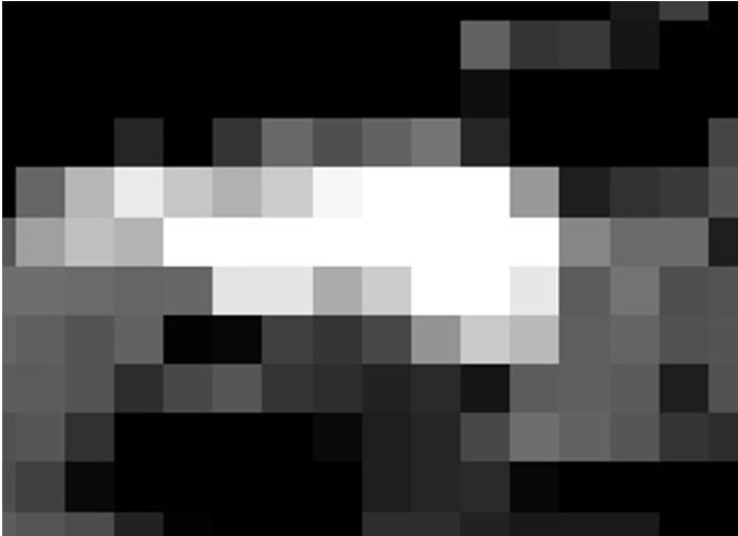


4 Fig 2 : Comparison of Results A B C D E F G H I 530


5 J K L M N Fig 3: NWDI Images of A- July 98, B - Oct 98, C- July99, D- Oct 2000, E- Aug 2002, F- Oct 2002,G- Oct 2009, H- Jul 2010, I Oct 2010, J Oct 2011, K Oct 2012, L- Oct 2013, M- Jul 2014,N Oct 2014 A B C D Fig 4 : Sub pixel images A- Jul 1998, B- Jul19 99, C- Jul-2010, Oct
6 TABLE II LAKE AREA CALCULATED USING CLASSIFICATION Year Area- Sub pixel NDWI(Threshold) Jul Oct Jul Jul Oct The underestimation of the water area is only 1.21%. However, the extracted water patches from the NDWI image were mixed with many built-up land patches with positive values. This results in the overestimation of the water area and a low accuracy of 77.25%. accuracy and Kappa value for the NDWI image but causes an underestimation of 21% of the water area.the results were compared to the existing topo maps available for the year 2011 and could be analysed that the area determined by using a threshold and a sub pixel approach approved to be more accurate as compared to the other methods used for determining the lake areas. Fig 5 : Comparison between subpixel and indices in lake area determination IV. CONCLUSIONS From the spectral reflectance pattern of clouds and cloud shadows, it can be observed that few sample pixels have lower reflectance values in NIR and SWIR bands compared to the green band. This implies that these pixels would be also be categorized as water, if the standard indexes such as NDWI/MNDWI were used so to remove this the sub pixel approach was used an enhanced area was calculated. Further, it is also clear from spectral plots of cloud that most of the cloud pixels have higher reflectance in all the bands and get eliminated by the brightness threshold limits. The cloud shadow has higher NDWI and thus can lead to an error in measuring area. To avoid this the threshold should be selected in such a way that the error to reduce the lake area should be minimized. REFERENCES [1] ICIMOD, Impact of climate change on Himalayan Glaciers and Glacial Lakes: Case studies on GLOF and Associated Hazards in Nepal and Bhutan, International Centre for Integrated Mountain Development(ICIMOD),2007. [2] ICIMOD, Formation of Glacial Lakes in the Hindu Kush-Himalayas and GLOF Risk Assessment. International Centre for Integrated Mountain Development, ICIMOD, [3] S.K. McFeeters, Using the normalized difference water index (NDWI) within a geographic information system to detect swimming pools for mosquito abatement: A practical approach, Remote Sens., 5, , [4] S.K. McFeeters, The use of the normalized difference water index (NDWI) in the delineation of open water features, Int. J. Remote Sens., 17, , [5] F. Sun, W. Sun, J. Chen, P. Gong, Comparison and improvement of methods for identifying waterbodies in remotely sensed imagery, Int. J. Remote Sens., 33, , [6] Bikram Pratap Banerjee, GLOF study using Remote Sensing and Ground Based Measurement Techniques, Indian Institute of Remote Sensing [7] H. Xu, Modification of normalised difference water index (NDWI) to enhance open water features in remotely sensed imagery. Int. J. Remote Sens., 27,
7 3033, [8] Z. Tang, W. Ou, Y. Dai, Y. Xin, Extraction of water body based on Landsat TM5 imagery A case study in the Yangtze river, Adv. Inf. Comm. Technol., 393, ,2013. [9] Hao Jiang; Min Feng; Yunqiang Zhu; Ning Lu; Jianxi Huang; Tong Xia. An Automated Method for Extracting Rivers and Lakes from Landsat Imagery. Remote Sens. 2014, 6, [10] Huggel, C., A. Kääb, W. Haeberli, P. Teysseire, and F. Paul "Remote sensing basedassessment of hazards from glacier lake outbursts: a case study in the Swiss Alps." NRC Research Press. doi: /T
Proceedings Combining Water Indices for Water and Background Threshold in Landsat Image
 Proceedings Combining Water Indices for Water and Background Threshold in Landsat Image Tri Dev Acharya 1, Anoj Subedi 2, In Tae Yang 1 and Dong Ha Lee 1, * 1 Department of Civil Engineering, Kangwon National
MONITORING OF GLACIAL CHANGE IN THE HEAD OF THE YANGTZE RIVER FROM 1997 TO 2007 USING INSAR TECHNIQUE
 MONITORING OF GLACIAL CHANGE IN THE HEAD OF THE YANGTZE RIVER FROM 1997 TO 2007 USING INSAR TECHNIQUE Hong an Wu a, *, Yonghong Zhang a, Jixian Zhang a, Zhong Lu b, Weifan Zhong a a Chinese Academy of
Skeletal remains of what was a debris-covered glacier near Mt. Everest
 Annual satellite imaging of the world s glaciers Assessment of glacier extent and change GLIMS Development and population of a digital glacier data inventory HIGH ICE Skeletal remains of what was a debris-covered
MONITORING OF SEASONAL SNOW COVER IN YAMUNA BASIN OF UTTARAKAHND HIMALAYA USING REMOTE SENSING TECHNIQUES
 MONITORING OF SEASONAL SNOW COVER IN YAMUNA BASIN OF UTTARAKAHND HIMALAYA USING REMOTE SENSING TECHNIQUES Anju Panwar, Devendra Singh Uttarakhand Space Application Centre, Dehradun, India ABSTRACT Himalaya
Preparation of LULC map from GE images for GIS based Urban Hydrological Modeling
 International Conference on Modeling Tools for Sustainable Water Resources Management Department of Civil Engineering, Indian Institute of Technology Hyderabad: 28-29 December 2014 Abstract Preparation
DAMAGE DETECTION OF THE 2008 SICHUAN, CHINA EARTHQUAKE FROM ALOS OPTICAL IMAGES
 DAMAGE DETECTION OF THE 2008 SICHUAN, CHINA EARTHQUAKE FROM ALOS OPTICAL IMAGES Wen Liu, Fumio Yamazaki Department of Urban Environment Systems, Graduate School of Engineering, Chiba University, 1-33,
1. Introduction. Jai Kumar, Paras Talwar and Krishna A.P. Department of Remote Sensing, Birla Institute of Technology, Ranchi, Jharkhand, India
 Cloud Publications International Journal of Advanced Remote Sensing and GIS 2015, Volume 4, Issue 1, pp. 1026-1032, Article ID Tech-393 ISSN 2320-0243 Research Article Open Access Forest Canopy Density
Object Based Land Cover Extraction Using Open Source Software
 Object Based Land Cover Extraction Using Open Source Software Abhasha Joshi 1, Janak Raj Joshi 2, Nawaraj Shrestha 3, Saroj Sreshtha 4, Sudarshan Gautam 5 1 Instructor, Land Management Training Center,
An information fusion approach for glacier mapping using multi-source remote sensing data
 An information fusion approach for glacier mapping using multi-source remote sensing data Ahmed Guermazi, Lionel Valet, Philippe Bolon LISTIC, Université de Savoie 74944 Annecy le Vieux FRANCE Email: {Ahmed.Guermazi,
Civil Engineering Journal
 Available online at www.civilejournal.org Civil Engineering Journal Vol. 1, No. 2, December, 2015 Comparative Study of Landsat and Aster Data by Morphometric Analysis Sujit Kumar a*, Tapasi Bhandary b
Land cover/land use mapping and cha Mongolian plateau using remote sens. Title. Author(s) Bagan, Hasi; Yamagata, Yoshiki. Citation Japan.
 Bagan, Hasi; Yamagata, Yoshiki. Citation Japan.") Title Land cover/land use mapping and cha Mongolian plateau using remote sens Author(s) Bagan, Hasi; Yamagata, Yoshiki International Symposium on "The Imp Citation Region Specific Systems". 6 Nove Japan.
Title Land cover/land use mapping and cha Mongolian plateau using remote sens Author(s) Bagan, Hasi; Yamagata, Yoshiki International Symposium on "The Imp Citation Region Specific Systems". 6 Nove Japan.
Remote Sensing for Climate Change Effect on Lake Tahoe. Shobha Sriharan Professor of Environmental Science Virginia State University
 Remote Sensing for Climate Change Effect on Lake Tahoe Shobha Sriharan Professor of Environmental Science Virginia State University Table of Contents Lake Tahoe s Climate Issues Discussion on the issues
LAND COVER CATEGORY DEFINITION BY IMAGE INVARIANTS FOR AUTOMATED CLASSIFICATION
 LAND COVER CATEGORY DEFINITION BY IMAGE INVARIANTS FOR AUTOMATED CLASSIFICATION Nguyen Dinh Duong Environmental Remote Sensing Laboratory Institute of Geography Hoang Quoc Viet Rd., Cau Giay, Hanoi, Vietnam
Geo-information and Disaster Risk Reduction in the Hindu Kush-Himalayan region
 Geo-information and Disaster Risk Reduction in the Hindu Kush-Himalayan region Basanta Shrestha, Division Head MENRIS, International Centre for Integrated Mountain Development Kathmandu, Nepal The International
Hazard Zonation for Glacial Lake Outburst Flood (GLOF) in Bhutan Himalaya
 in Bhutan Himalaya") Hazard Zonation for Glacial Lake Outburst Flood (GLOF) in Bhutan Himalaya A mode of Adaptation to the impacts of climate change DGM-NCAP Project Karma Department of Geology & Mines Ministry of Economic
Hazard Zonation for Glacial Lake Outburst Flood (GLOF) in Bhutan Himalaya A mode of Adaptation to the impacts of climate change DGM-NCAP Project Karma Department of Geology & Mines Ministry of Economic
Monitoring and Change Detection along the Eastern Side of Qena Bend, Nile Valley, Egypt Using GIS and Remote Sensing
 Advances in Remote Sensing, 2013, 2, 276-281 http://dx.doi.org/10.4236/ars.2013.23030 Published Online September 2013 (http://www.scirp.org/journal/ars) Monitoring and Change Detection along the Eastern
Glaciers and climate change Jon Ove Hagen, Department of Geosciences University of Oslo
 Glaciers and climate change Jon Ove Hagen, Department of Geosciences University of Oslo joh@geo.uio.no Department of geosciences, Faculty of Mathematics and Natural Sciences Glaciers and climate change
Uncertainties of snow cover extraction caused by the nature of topography and underlying surface
 J Arid Land (2015) 7(3): 285 295 doi: 10.1007/s40333-015-0044-x jal.xjegi.com; www.springer.com/40333 Uncertainties of snow cover extraction caused by the nature of topography and underlying surface Jun
AUTOMATISIERTE ZEITREIHENANALYSE VON FERNERKUNDUNGSDATEN FÜR DAS MONITORING VON OBERFLÄCHENGEWÄSSERN
 Place image here (10 x 3.5 ) AUTOMATISIERTE ZEITREIHENANALYSE VON FERNERKUNDUNGSDATEN FÜR DAS MONITORING VON OBERFLÄCHENGEWÄSSERN THOMAS BAHR & NICOLAI HOLZER 23. Workshop Arbeitskreis Umweltinformationssysteme
Remote Sensing of Snow GEOG 454 / 654
 Remote Sensing of Snow GEOG 454 / 654 What crysopheric questions can RS help to answer? 2 o Where is snow lying? (Snow-covered area or extent) o How much is there? o How rapidly is it melting? (Area, depth,
AssessmentofUrbanHeatIslandUHIusingRemoteSensingandGIS
 Global Journal of HUMANSOCIAL SCIENCE: B Geography, GeoSciences, Environmental Science & Disaster Management Volume 16 Issue 2 Version 1.0 Type: Double Blind Peer Reviewed International Research Journal
MODELLING FUTURE CHANGES IN CRYOSPHERE OF INDUS BASIN
 MODELLING FUTURE CHANGES IN CRYOSPHERE OF INDUS BASIN ANIL V. KULKARNI DISTINGUISHED VISITING SCIENTIST DIVECHA CENTRE FOR CLIMATE CHANGE INDIAN INSTITUTE OF SCIENCE BANGALORE 560012 INDIA Presented at
Abstract. TECHNOFAME- A Journal of Multidisciplinary Advance Research. Vol.2 No. 2, (2013) Received: Feb.2013; Accepted Oct.
 Received: Feb.2013; Accepted Oct.") Vol.2 No. 2, 83-87 (2013) Received: Feb.2013; Accepted Oct. 2013 Landuse Pattern Analysis Using Remote Sensing: A Case Study of Morar Block, of Gwalior District, M.P. Subhash Thakur 1 Akhilesh Singh 2
Vol.2 No. 2, 83-87 (2013) Received: Feb.2013; Accepted Oct. 2013 Landuse Pattern Analysis Using Remote Sensing: A Case Study of Morar Block, of Gwalior District, M.P. Subhash Thakur 1 Akhilesh Singh 2
Urban Area Delineation Using Pattern Recognition Technique
 Cloud Publications International Journal of Advanced Remote Sensing and GIS 2018, Volume 7, Issue 1, pp. 2466-2470 ISSN 2320 0243, Crossref: 10.23953/cloud.ijarsg.333 Methodology Article Urban Area Delineation
Vegetation Change Detection of Central part of Nepal using Landsat TM
 Vegetation Change Detection of Central part of Nepal using Landsat TM Kalpana G. Bastakoti Department of Geography, University of Calgary, kalpanagb@gmail.com Abstract This paper presents a study of detecting
CHANGE DETECTION USING REMOTE SENSING- LAND COVER CHANGE ANALYSIS OF THE TEBA CATCHMENT IN SPAIN (A CASE STUDY)
") CHANGE DETECTION USING REMOTE SENSING- LAND COVER CHANGE ANALYSIS OF THE TEBA CATCHMENT IN SPAIN (A CASE STUDY) Sharda Singh, Professor & Programme Director CENTRE FOR GEO-INFORMATICS RESEARCH AND TRAINING
CHANGE DETECTION USING REMOTE SENSING- LAND COVER CHANGE ANALYSIS OF THE TEBA CATCHMENT IN SPAIN (A CASE STUDY) Sharda Singh, Professor & Programme Director CENTRE FOR GEO-INFORMATICS RESEARCH AND TRAINING
Rio Santa Geodatabase Project
 Rio Santa Geodatabase Project Amanda Cuellar December 7, 2012 Introduction The McKinney research group (of which I am a part) collaborates with international and onsite researchers to evaluate the risks
STUDY ON TYPE AND DISTRIBUTION OF WETLANDS OF SIKKIM HIMALAYAS USING SATELLITE IMAGERY WITH REMOTE SENSING & GIS TECHNIQUE
 STUDY ON TYPE AND DISTRIBUTION OF WETLANDS OF SIKKIM HIMALAYAS USING SATELLITE IMAGERY WITH REMOTE SENSING & GIS TECHNIQUE Narpati Sharma, Safal Pradhan, M. L. Arrawatia and D.G. Shrestha Department of
7.1 INTRODUCTION 7.2 OBJECTIVE
 7 LAND USE AND LAND COVER 7.1 INTRODUCTION The knowledge of land use and land cover is important for many planning and management activities as it is considered as an essential element for modeling and
Effect of land use/land cover changes on runoff in a river basin: a case study
 Water Resources Management VI 139 Effect of land use/land cover changes on runoff in a river basin: a case study J. Letha, B. Thulasidharan Nair & B. Amruth Chand College of Engineering, Trivandrum, Kerala,
ASTER DEM Based Studies for Geological and Geomorphological Investigation in and around Gola block, Ramgarh District, Jharkhand, India
 International Journal of Scientific & Engineering Research, Volume 3, Issue 2, February-2012 1 ASTER DEM Based Studies for Geological and Geomorphological Investigation in and around Gola block, Ramgarh
Digital Change Detection Using Remotely Sensed Data for Monitoring Green Space Destruction in Tabriz
 Int. J. Environ. Res. 1 (1): 35-41, Winter 2007 ISSN:1735-6865 Graduate Faculty of Environment University of Tehran Digital Change Detection Using Remotely Sensed Data for Monitoring Green Space Destruction
Module 2.1 Monitoring activity data for forests using remote sensing
 Module 2.1 Monitoring activity data for forests using remote sensing Module developers: Frédéric Achard, European Commission (EC) Joint Research Centre (JRC) Jukka Miettinen, EC JRC Brice Mora, Wageningen
Introduction to Satellite Derived Vegetation Indices
 Introduction to the Use of Geospatial Information Technology for Drought Risk Management 13-17 November, 2017 Tonle Bassac II Restaurant, Phnom Penh, Cambodia Introduction to Satellite Derived Vegetation
This is trial version
 Journal of Rangeland Science, 2012, Vol. 2, No. 2 J. Barkhordari and T. Vardanian/ 459 Contents available at ISC and SID Journal homepage: www.rangeland.ir Full Paper Article: Using Post-Classification
1. Introduction. Chaithanya, V.V. 1, Binoy, B.V. 2, Vinod, T.R. 2. Publication Date: 8 April DOI: https://doi.org/ /cloud.ijarsg.
 Cloud Publications International Journal of Advanced Remote Sensing and GIS 2017, Volume 6, Issue 1, pp. 2088-2096 ISSN 2320 0243, Crossref: 10.23953/cloud.ijarsg.112 Research Article Open Access Estimation
CHANGES IN VIJAYAWADA CITY BY REMOTE SENSING AND GIS
 International Journal of Civil Engineering and Technology (IJCIET) Volume 8, Issue 5, May 2017, pp.217 223, Article ID: IJCIET_08_05_025 Available online at http://www.ia aeme.com/ijciet/issues.asp?jtype=ijciet&vtyp
SUPPORTING INFORMATION. Ecological restoration and its effects on the
 SUPPORTING INFORMATION Ecological restoration and its effects on the regional climate: the case in the source region of the Yellow River, China Zhouyuan Li, Xuehua Liu,* Tianlin Niu, De Kejia, Qingping
FLOOD DAMAGE ASSESSMENT INTEGRATING GEOSPATIAL TECHNOLOGIES. A CASE STUDY IN HUE, VIET NAM
 Paper 5-4-2 FLOOD DAMAGE ASSESSMENT INTEGRATING GEOSPATIAL TECHNOLOGIES. A CASE STUDY IN HUE, VIET NAM DINH NGOC DAT, J. S. M. FOWZE, NGUYEN DUONG ANH, MANZUL K. HAZARIKA AND LAL SAMARAKOON GeoInformatics
ESTIMATING SNOWMELT CONTRIBUTION FROM THE GANGOTRI GLACIER CATCHMENT INTO THE BHAGIRATHI RIVER, INDIA ABSTRACT INTRODUCTION
 ESTIMATING SNOWMELT CONTRIBUTION FROM THE GANGOTRI GLACIER CATCHMENT INTO THE BHAGIRATHI RIVER, INDIA Rodney M. Chai 1, Leigh A. Stearns 2, C. J. van der Veen 1 ABSTRACT The Bhagirathi River emerges from
CEOS Landslide Pilot Chinese Region:
 CEOS Working Group on Disasters Meeting #9 CEOS Landslide Pilot Chinese Region: a recent progress Ziyang Li zyli@aoe.ac.cn Key Laboratory of Quantitative Remote Sensing Information Technology, Academy
CONTINUOUS MAPPING OF THE ALQUEVA REGION OF PORTUGAL USING SATELLITE IMAGERY
 CONTINUOUS MAPPING OF THE ALQUEVA REGION OF PORTUGAL USING SATELLITE IMAGERY Célia Gouveia 1,2 and Carlos DaCamara 2 1 Escola Superior de Tecnologia, Instituto Politécnico de Setúbal, Setúbal. Portugal;
Combination of Microwave and Optical Remote Sensing in Land Cover Mapping
 Combination of Microwave and Optical Remote Sensing in Land Cover Mapping Key words: microwave and optical remote sensing; land cover; mapping. SUMMARY Land cover map mapping of various types use conventional
Monitoring of Temporal Variation of Snow Depth Using Remote Sensing in Western Himalaya
 Monitoring of Temporal Variation of Snow Depth Using Remote Sensing in Western Himalaya Ruby Nanchahal*, H. S. Gusain**, Darshan Singh Sidhu* and V. D. Mishra** *PTU GZS Campus Bathinda, Punjab, 151 001,
Landuse and Landcover change analysis in Selaiyur village, Tambaram taluk, Chennai
 Landuse and Landcover change analysis in Selaiyur village, Tambaram taluk, Chennai K. Ilayaraja Department of Civil Engineering BIST, Bharath University Selaiyur, Chennai 73 ABSTRACT The synoptic picture
Estimation of Wavelet Based Spatially Enhanced Evapotranspiration Using Energy Balance Approach
 Estimation of Wavelet Based Spatially Enhanced Evapotranspiration Using Energy Balance Approach Dr.Gowri 1 Dr.Thirumalaivasan 2 1 Associate Professor, Jerusalem College of Engineering, Department of Civil
The Hindu Kush-Himalayan (HKH) region
 region") Understanding the Dynamics of Snow and Glaciers in the Hindu Kush-Himalayan Region Deo Raj Gurung, Remote Sensing Specialist, MENRIS, ICIMOD, drgurung@icimod.org Samjwal Ratna Bajracharya, Remote Sensing
Understanding the Dynamics of Snow and Glaciers in the Hindu Kush-Himalayan Region Deo Raj Gurung, Remote Sensing Specialist, MENRIS, ICIMOD, drgurung@icimod.org Samjwal Ratna Bajracharya, Remote Sensing
Changing glacial lakes and associated outburst floods risks in Nanda Devi Biosphere Reserve, Indian Himalaya
 Evolving Water Resources Systems: Understanding, Predicting and Managing Water Society Interactions Proceedings of ICWRS2014, Bologna, Italy, June 2014 (IAHS Publ. 364, 2014). 255 Changing glacial lakes
1. Introduction. S.S. Patil 1, Sachidananda 1, U.B. Angadi 2, and D.K. Prabhuraj 3
 Cloud Publications International Journal of Advanced Remote Sensing and GIS 2014, Volume 3, Issue 1, pp. 525-531, Article ID Tech-249 ISSN 2320-0243 Research Article Open Access Machine Learning Technique
Detecting, Extracting and Monitoring Surface Water Using Space Technologies
 Detecting, Extracting and Monitoring Surface Water Using Space Technologies The 4 th International Conference on the Use of Space Technology for Water Management Islamabad, Pakistan, 27 February 2018 Dr
Monitoring and evaluation of seasonal snow cover in Kashmir valley using remote sensing, GIS and ancillary data
 Monitoring and evaluation of seasonal snow cover in Kashmir valley using remote sensing, GIS and ancillary data HSNegi, N K Thakur, Rajeev Kumar and Manoj Kumar Snow and Avalanche Study Establishment,
An Automated Object-Oriented Satellite Image Classification Method Integrating the FAO Land Cover Classification System (LCCS).
.") An Automated Object-Oriented Satellite Image Classification Method Integrating the FAO Land Cover Classification System (LCCS). Ruvimbo Gamanya Sibanda Prof. Dr. Philippe De Maeyer Prof. Dr. Morgan De
An Automated Object-Oriented Satellite Image Classification Method Integrating the FAO Land Cover Classification System (LCCS). Ruvimbo Gamanya Sibanda Prof. Dr. Philippe De Maeyer Prof. Dr. Morgan De
Data challenges in Trans-boundary River Basins: Case Study of the Upper Indus Basin
 Data challenges in Trans-boundary River Basins: Case Study of the Upper Indus Basin Asif Khan Lead Author (Water chapter- AR6 IPCC) Post Doctorate (Water-Energy-Food-Climate Change, IIASA, Austria) PhD
Methods review for the Global Land Cover 2000 initiative Presentation made by Frédéric Achard on November 30 th 2000
 Methods review for the Global Land Cover 2000 initiative Presentation made by Frédéric Achard on November 30 th 2000 1. Contents Objectives Specifications of the GLC-2000 exercise Strategy for the analysis
MAPPING LAND USE/ LAND COVER OF WEST GODAVARI DISTRICT USING NDVI TECHNIQUES AND GIS Anusha. B 1, Sridhar. P 2
 MAPPING LAND USE/ LAND COVER OF WEST GODAVARI DISTRICT USING NDVI TECHNIQUES AND GIS Anusha. B 1, Sridhar. P 2 1 M. Tech. Student, Department of Geoinformatics, SVECW, Bhimavaram, A.P, India 2 Assistant
CHAPTER-7 INTERFEROMETRIC ANALYSIS OF SPACEBORNE ENVISAT-ASAR DATA FOR VEGETATION CLASSIFICATION
 147 CHAPTER-7 INTERFEROMETRIC ANALYSIS OF SPACEBORNE ENVISAT-ASAR DATA FOR VEGETATION CLASSIFICATION 7.1 INTRODUCTION: Interferometric synthetic aperture radar (InSAR) is a rapidly evolving SAR remote
Dealing with climate-change impacts on glacier and permafrost hazards: adaptation strategies in mountain regions
 Dealing with climate-change impacts on glacier and permafrost hazards: adaptation strategies in mountain regions Christian Huggel Luzia Fischer, Wilfried Haeberli, Stephan Gruber, Jeannette Nötzli Glaciology
Remote Sensing and GIS Application in Change Detection Study Using Multi Temporal Satellite
 Cloud Publications International Journal of Advanced Remote Sensing and GIS 2013, Volume 2, Issue 1, pp. 374-378, Article ID Tech-181 ISSN 2320-0243 Case Study Open Access Remote Sensing and GIS Application
Decadal glacial lake changes in the Koshi basin, central Himalaya, from 1977 to 2010, derived from Landsat satellite images
 e-mail: jms@imde.ac.cn http://jms.imde.ac.cn https://doi.org/10.1007/s11629-016-4230-x Decadal glacial lake changes in the Koshi basin, central Himalaya, from 1977 to 2010, derived from Landsat satellite
Yanbo Huang and Guy Fipps, P.E. 2. August 25, 2006
 Landsat Satellite Multi-Spectral Image Classification of Land Cover Change for GIS-Based Urbanization Analysis in Irrigation Districts: Evaluation in Low Rio Grande Valley 1 by Yanbo Huang and Guy Fipps,
Accuracy Assessment of Land Cover Classification in Jodhpur City Using Remote Sensing and GIS
 Accuracy Assessment of Land Cover Classification in Jodhpur City Using Remote Sensing and GIS S.L. Borana 1, S.K.Yadav 1 Scientist, RSG, DL, Jodhpur, Rajasthan, India 1 Abstract: A This study examines
Regional Glacier Mapping Using Optical Satellite Data Time Series Solveig Havstad Winsvold, Andreas Kääb, Member, IEEE, and Christopher Nuth
 IEEE JOURNAL OF SELECTED TOPICS IN APPLIED EARTH OBSERVATIONS AND REMOTE SENSING 1 Regional Glacier Mapping Using Optical Satellite Data Time Series Solveig Havstad Winsvold, Andreas Kääb, Member, IEEE,
Supplementary Materials for
 advances.sciencemag.org/cgi/content/full/3/12/e1701169/dc1 Supplementary Materials for Abrupt shift in the observed runoff from the southwestern Greenland ice sheet Andreas P. Ahlstrøm, Dorthe Petersen,
ESTIMATION OF LANDFORM CLASSIFICATION BASED ON LAND USE AND ITS CHANGE - Use of Object-based Classification and Altitude Data -
 ESTIMATION OF LANDFORM CLASSIFICATION BASED ON LAND USE AND ITS CHANGE - Use of Object-based Classification and Altitude Data - Shoichi NAKAI 1 and Jaegyu BAE 2 1 Professor, Chiba University, Chiba, Japan.
Distribution of seasonal snow cover in central and western Himalaya
 Annals of Glaciology 51(54) 2010 123 Distribution of seasonal snow cover in central and western Himalaya Anil V. KULKARNI, B.P. RATHORE, S.K. SINGH, AJAI Earth Sciences and Hydrology Division, Marine and
RESEARCH METHODOLOGY
 III. RESEARCH METHODOLOGY 3.1. Time and Research Area The field work was taken place in primary forest around Toro village in Lore Lindu National Park, Indonesia. The study area located in 120 o 2 53 120
Country Report Nepal Geospatial Data Sharing Initiatives of Survey Department Supporting Disaster Management
 Third JPTM Step 2 for Sentinel Asia 6-8 July, 2010 Manila, The Philippines Country Report Nepal Geospatial Data Sharing Initiatives of Survey Department Supporting Disaster Management Durgendra M Kayastha
Review Using the Geographical Information System and Remote Sensing Techniques for Soil Erosion Assessment
 Polish J. of Environ. Stud. Vol. 19, No. 5 (2010), 881-886 Review Using the Geographical Information System and Remote Sensing Techniques for Soil Erosion Assessment Nuket Benzer* Landscape Architecture
Mapping Glaciers and surging glaciers in the Karakoram using satellite data
 Mapping Glaciers and surging glaciers in the Karakoram using satellite data Frank Paul Department of Geography University of Zurich Sentinel 2: Copernicus 2015! Satellites Image source: Internet Landsat
Field Based Spectral Reflectance Studies to Develop NDSI Method for Snow Cover Monitoring
 Photonirvachak Journal of the Indian Society of Remote Sensing, Vol. 30, No. 1&2, 2002 Field Based Spectral Reflectance Studies to Develop NDSI Method for Snow Cover Monitoring A V KULKARNP, J SRINIVASULU
Mongolian Academy of Sciences
 Mongolian Academy of Sciences Figure 5. Change of subsurface profile temperature at some observation well in Jakarta. Figure 6. Change of air temperature in Jakarta in the period of 100 years (KLH, BMG,
Using MODIS imagery to validate the spatial representation of snow cover extent obtained from SWAT in a data-scarce Chilean Andean watershed
 Using MODIS imagery to validate the spatial representation of snow cover extent obtained from SWAT in a data-scarce Chilean Andean watershed Alejandra Stehr 1, Oscar Link 2, Mauricio Aguayo 1 1 Centro
STUDY ON FOREST VEGETATION CLASSIFICATION BASED ON MULTI- TEMPORAL REMOTE SENSING IMAGES
 STUDY ON FOREST VEGETATION CLASSIFICATION BASED ON MULTI- TEMPORAL REMOTE SENSING IMAGES Xia Jing 1, 2, JiHua Wang 2, WenJiang Huang 2,*, LiangYun Liu 2, JinDi Wang 1 1 School of Geography, Beijing Normal
IMPROVING REMOTE SENSING-DERIVED LAND USE/LAND COVER CLASSIFICATION WITH THE AID OF SPATIAL INFORMATION
 IMPROVING REMOTE SENSING-DERIVED LAND USE/LAND COVER CLASSIFICATION WITH THE AID OF SPATIAL INFORMATION Yingchun Zhou1, Sunil Narumalani1, Dennis E. Jelinski2 Department of Geography, University of Nebraska,
River Ice Delineation with RADARSAT SAR
 CGU HS Committee on River Ice Processes and the Environment 12th Workshop on the Hydraulics of Ice Covered Rivers Edmonton, AB, June 19-20, 2003 River Ice Delineation with RADARSAT SAR Brian T. Tracy and
EFFECT OF ANCILLARY DATA ON THE PERFORMANCE OF LAND COVER CLASSIFICATION USING A NEURAL NETWORK MODEL. Duong Dang KHOI.
 EFFECT OF ANCILLARY DATA ON THE PERFORMANCE OF LAND COVER CLASSIFICATION USING A NEURAL NETWORK MODEL Duong Dang KHOI 1 10 Feb, 2011 Presentation contents 1. Introduction 2. Methods 3. Results 4. Discussion
Landcover Dynamics in the Niger Inland Delta (Mali)
") Fakultät Forst-, Geo- Hydrowissenschaften Institut f. Photogrammetrie & Fernerkundung, Professur Fernerkundung Landcover Dynamics in the Niger Inland Delta (Mali) A Classification Approach for MERIS Data
Fakultät Forst-, Geo- Hydrowissenschaften Institut f. Photogrammetrie & Fernerkundung, Professur Fernerkundung Landcover Dynamics in the Niger Inland Delta (Mali) A Classification Approach for MERIS Data
STUDY OF NORMALIZED DIFFERENCE BUILT-UP (NDBI) INDEX IN AUTOMATICALLY MAPPING URBAN AREAS FROM LANDSAT TM IMAGERY
 INDEX IN AUTOMATICALLY MAPPING URBAN AREAS FROM LANDSAT TM IMAGERY") STUDY OF NORMALIZED DIFFERENCE BUILT-UP (NDBI) INDEX IN AUTOMATICALLY MAPPING URBAN AREAS FROM LANDSAT TM IMAGERY Dr. Hari Krishna Karanam Professor, Civil Engineering, Dadi Institute of Engineering &
STUDY OF NORMALIZED DIFFERENCE BUILT-UP (NDBI) INDEX IN AUTOMATICALLY MAPPING URBAN AREAS FROM LANDSAT TM IMAGERY Dr. Hari Krishna Karanam Professor, Civil Engineering, Dadi Institute of Engineering &
International Journal of Intellectual Advancements and Research in Engineering Computations
 ISSN:2348-2079 Volume-5 Issue-2 International Journal of Intellectual Advancements and Research in Engineering Computations Agricultural land investigation and change detection in Coimbatore district by
Joint International Mechanical, Electronic and Information Technology Conference (JIMET 2015)
") Joint International Mechanical, Electronic and Information Technology Conference (JIMET 2015) Extracting Land Cover Change Information by using Raster Image and Vector Data Synergy Processing Methods Tao
Joint International Mechanical, Electronic and Information Technology Conference (JIMET 2015) Extracting Land Cover Change Information by using Raster Image and Vector Data Synergy Processing Methods Tao
RESPONSE OF PERMAFROST TO GLOBAL CHANGE ON THE QINGHAI-XIZANG PLATEAUÑ A GIS-AIDED MODEL
 RESPONSE OF PERMAFROST TO GLOBAL CHANGE ON THE QINGHAI-XIZANG PLATEAUÑ A GIS-AIDED MODEL Li Xin, Cheng Guodong, Chen Xianzhang State Key Laboratory of Frozen Soil Engineering, Lanzhou Institute of Glaciology
VISUALIZATION URBAN SPATIAL GROWTH OF DESERT CITIES FROM SATELLITE IMAGERY: A PRELIMINARY STUDY
 CO-439 VISUALIZATION URBAN SPATIAL GROWTH OF DESERT CITIES FROM SATELLITE IMAGERY: A PRELIMINARY STUDY YANG X. Florida State University, TALLAHASSEE, FLORIDA, UNITED STATES ABSTRACT Desert cities, particularly
Radar mapping of snow melt over mountain glaciers in High Mountain Asia Mentor: Tarendra Lakhankar Collaborators: Nir Krakauer, Kyle MacDonald and
 Radar mapping of snow melt over mountain glaciers in High Mountain Asia Mentor: Tarendra Lakhankar Collaborators: Nir Krakauer, Kyle MacDonald and Nick Steiner How are Glaciers Formed? Glaciers are formed
A NOVEL APPROACH TO MEASURE THE CHANGES IN GLACIER EXTENT OF GANGOTRI GLACIER
 A NOVEL APPROACH TO MEASURE THE CHANGES IN GLACIER EXTENT OF GANGOTRI GLACIER M Anul Haq 1, Dr. Kamal Jain 1, Dr K.P.R. Menon 2 1 Department of Civil Engineering, Indian Institute of Technology, Roorkee,
M.C.PALIWAL. Department of Civil Engineering NATIONAL INSTITUTE OF TECHNICAL TEACHERS TRAINING & RESEARCH, BHOPAL (M.P.), INDIA
, INDIA") INVESTIGATIONS ON THE ACCURACY ASPECTS IN THE LAND USE/LAND COVER MAPPING USING REMOTE SENSING SATELLITE IMAGERY By M.C.PALIWAL Department of Civil Engineering NATIONAL INSTITUTE OF TECHNICAL TEACHERS
INVESTIGATIONS ON THE ACCURACY ASPECTS IN THE LAND USE/LAND COVER MAPPING USING REMOTE SENSING SATELLITE IMAGERY By M.C.PALIWAL Department of Civil Engineering NATIONAL INSTITUTE OF TECHNICAL TEACHERS
Estimating Glacial Volume on the Tibetan Plateau: A Combination Approach of Numerical Modeling and Remote Sensing
 Estimating Glacial Volume on the Tibetan Plateau: A Combination Approach of Numerical Modeling and Remote Sensing Introduction The retreat of the Antarctic and Greenland ice sheets, as well as that of
Detection of Sea Ice/ Melt Pond from Aerial Photos through Object-based Image Classification Scheme
 NEMC 213 August 5-9, San Antonio, TX Detection of Sea Ice/ Melt Pond from Aerial Photos through Object-based Image Classification Scheme Xin Miao 12, Hongjie Xie 2, Zhijun Li 3, Ruibo Lei 4 1 Department
Comparison of remote sensing derived glacier facies maps with distributed mass balance modelling at Engabreen, northern Norway
 126 Glacier Mass Balance Changes and Meltwater Discharge (selected papers from sessions at the IAHS Assembly in Foz do Iguaçu, Brazil, 2005). IAHS Publ. 318, 2007. Comparison of remote sensing derived
Outline. Remote Sensing, GIS and DEM Applications for Flood Monitoring. Introduction. Satellites and their Sensors used for Flood Mapping
 Outline Remote Sensing, GIS and DEM Applications for Flood Monitoring Prof. D. Nagesh Kumar Chairman, Centre for Earth Sciences Professor, Dept. of Civil Engg. Indian Institute of Science Bangalore 560
CHAPTER VII FULLY DISTRIBUTED RAINFALL-RUNOFF MODEL USING GIS
 80 CHAPTER VII FULLY DISTRIBUTED RAINFALL-RUNOFF MODEL USING GIS 7.1GENERAL This chapter is discussed in six parts. Introduction to Runoff estimation using fully Distributed model is discussed in first
Soil Erosion Calculation using Remote Sensing and GIS in Río Grande de Arecibo Watershed, Puerto Rico
 Soil Erosion Calculation using Remote Sensing and GIS in Río Grande de Arecibo Watershed, Puerto Rico Alejandra M. Rojas González Department of Civil Engineering University of Puerto Rico at Mayaguez.
Spatial Drought Assessment Using Remote Sensing and GIS techniques in Northwest region of Liaoning, China
 Spatial Drought Assessment Using Remote Sensing and GIS techniques in Northwest region of Liaoning, China FUJUN SUN, MENG-LUNG LIN, CHENG-HWANG PERNG, QIUBING WANG, YI-CHIANG SHIU & CHIUNG-HSU LIU Department
IMAGE CLASSIFICATION TOOL FOR LAND USE / LAND COVER ANALYSIS: A COMPARATIVE STUDY OF MAXIMUM LIKELIHOOD AND MINIMUM DISTANCE METHOD
 IMAGE CLASSIFICATION TOOL FOR LAND USE / LAND COVER ANALYSIS: A COMPARATIVE STUDY OF MAXIMUM LIKELIHOOD AND MINIMUM DISTANCE METHOD Manisha B. Patil 1, Chitra G. Desai 2 and * Bhavana N. Umrikar 3 1 Department
Abstract: Introduction: 10 th ESRI India User Conference 2009 Geography in Action
 Mitigation of Thermal Pollution to enhance urban air quality through Remote Sensing and GIS Anshu Gupta, Lecturer, Centre of Remote Sensing and GIS, MANIT, Bhopal, E- mail: anshugupta20002001@gmail.com
The Importance of Snowmelt Runoff Modeling for Sustainable Development and Disaster Prevention
 The Importance of Snowmelt Runoff Modeling for Sustainable Development and Disaster Prevention Muzafar Malikov Space Research Centre Academy of Sciences Republic of Uzbekistan Water H 2 O Gas - Water Vapor
Remote sensing Based Assessment of Urban Heat Island Phenomenon in Nagpur Metropolitan Area
 International Journal of Information & Computation Technology. ISSN 0974-2239 Volume 4, Number 11 (2014), pp. 1069-1074 International Research Publications House http://www. irphouse.com Remote sensing
THERMAL REMOTE SENSING TECHNIQUES FOR STUDYING EARTHQUAKE ANOMALIES IN 2013 BALOCHISTAN EARTHQUAKES. G. Kaplan 1 and U. Avdan 2
 THERMAL REMOTE SENSING TECHNIQUES FOR STUDYING EARTHQUAKE ANOMALIES IN 2013 BALOCHISTAN EARTHQUAKES ABSTRACT: G. Kaplan 1 and U. Avdan 2 1 PhD Candidate, GIS and Remote Sensing program, Anadolu University,
Pixel-based and object-based landslide mapping: a methodological comparison
 Pixel-based and object-based landslide mapping: a methodological comparison Daniel HÖLBLING 1, Tsai-Tsung TSAI 2, Clemens EISANK 1, Barbara FRIEDL 1, Chjeng-Lun SHIEH 2, and Thomas BLASCHKE 1 1 Department
Research highlights from permafrost research: Rock glacier mapping in the HKH region with Google Earth
 Research highlights from permafrost research: Rock glacier mapping in the HKH region with Google Earth M.-O. Schmid, P. Baral, S. Gruber, S. Shahi, T. Shrestha, D. Stumm, and P. Wester International Centre
Evaluation of distributed snowpack simulation with in-situ and remote sensing information in Arveupper catchment
 Evaluation of distributed snowpack simulation with in-situ and remote sensing information in Arveupper catchment J. Revuelto 1,2, G. Lecourt 2, L. Charrois 2, T. Condom 1, M. Dumont 2, M. Lafaysse 2,,