A 40-year climatology of extratropical transition in the eastern North Pacific continued (and some other stuff)
|
|
|
- Emmeline Moore
- 5 years ago
- Views:
Transcription
1 GOES-EAST image of Hurricane Dora, 1445 UTC 21 July 2011 A 40-year climatology of extratropical transition in the eastern North Pacific continued (and some other stuff) Elizabeth A. Ritchie and Kimberly M. Wood & David Kofron and Steven Felker and Scott Tyo The University of Arizona


2 Extratropical Transition 19 UTC 16 August UTC 18 August UTC 20 August UTC 21 August 2009 Extratropical Transition = decay of a tropical cyclone in conjunction with a mid-latitude feature (trough, preexisting cyclone, etc.) into an extratropical cyclone


3 Extratropical Transition All TC Tracks Guillermo Extratropical Transition Tracks Guillermo


4 Extratropical Transition

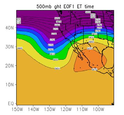

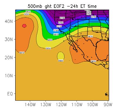
5 Extratropical Transition EOF 1 38% variance 44% 53% 19% variance EOF 2
6 Dissipaters vs. Intensifiers NOGAPS 1 Analyses from 2003 to re-curving TCs Separate into two classes: Intensifiers Dissipaters Define Reintensification: ΔP drop of 3 hpa P i, j is sea level pressure at the (i, j) point on grid. 1 P = n m n m i= 1 j= 1 P i P, j central Central pressure change relative to environmental pressure Use open wave definition for ET time (Demirci et al. 2007) (Kofron et al. 2010a,b)

7 Previous Work All 82 cases: Isentropic Potential Vorticity averaged within 500-km of TC center (Kofron et al. 2010a,b)


8 IPV Post-ET reintensification cases w/ an upstream interaction (Cold-core evolution): Post-ET dissipation: (Kofron et al. 2010a,b)
9 Previous Work Isentropic Potential Vorticity averaged within 500-km of TC center IPV [PVU] Average 330-K IPV 330-K IPV Minimum Centered NW Trough Cold-Core NW Trough Warm Seclusion NE Trough Post-ET Dissipater Non-ET Time [hr]


10 Intensifiers Eastern North Pacific Dissipaters Dissipaters Jimena 2009 Rick 2009 Dora 2011 Blas 2004 Dissipate Dissipate Dissipate Dissipate Otis 2005 Juliette 2007 Kiko 2007 Norbert 2008 Dissipate Maintain/Dissipate Dissipate Maintain/Intensify


11 Intensifiers Eastern North Pacific Dissipaters Intensifiers John 1994 Guillermo 1997 Ignacio 1997 Intensify Maintains Intensify Blanca 2009 Dolores2009 Guillermo 2009 Ignacio 2009 Intensify Maintains Intensify Intensify **Based on NHC Best Track data

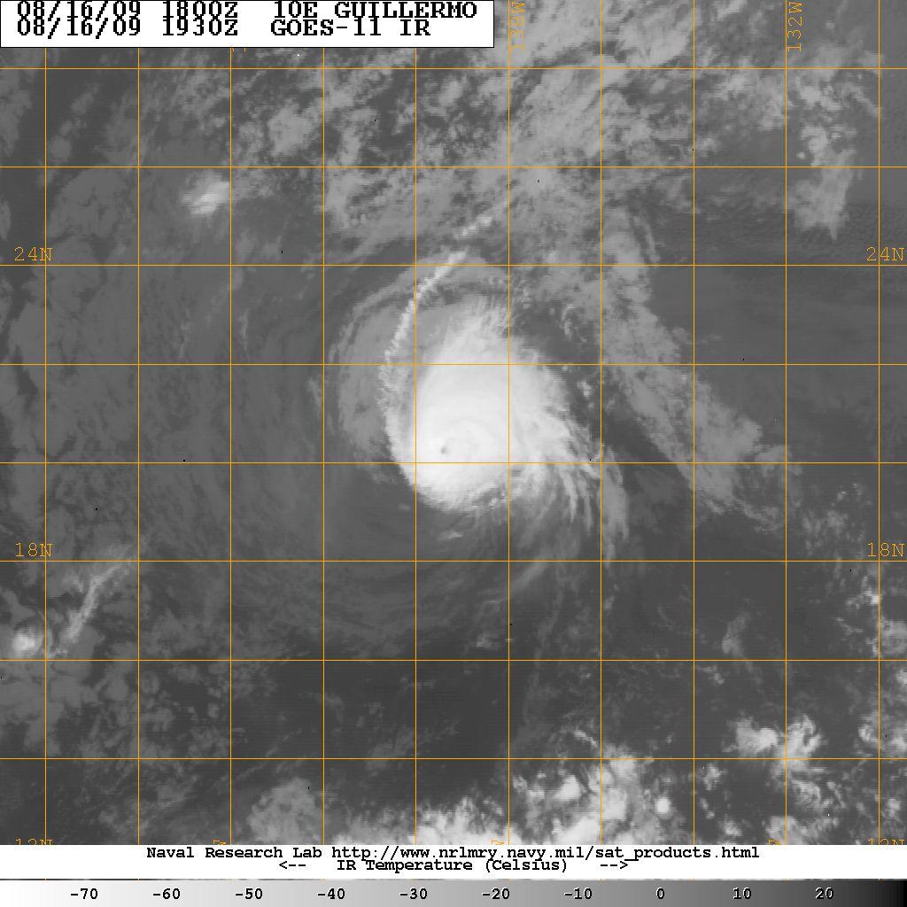
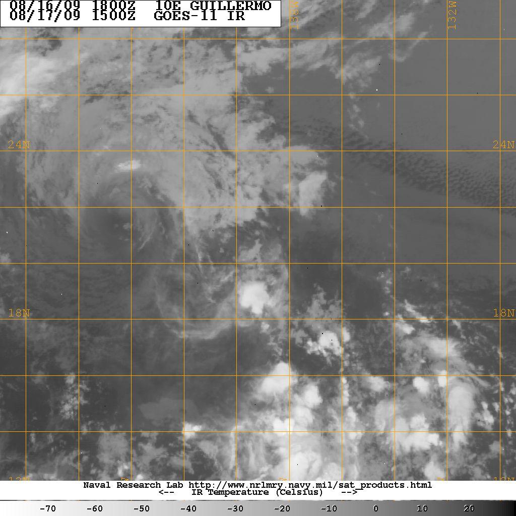
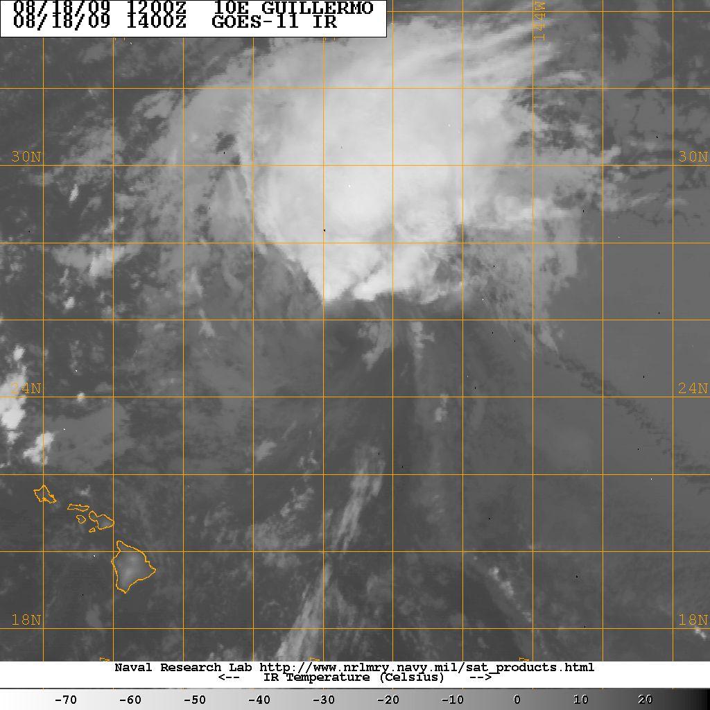
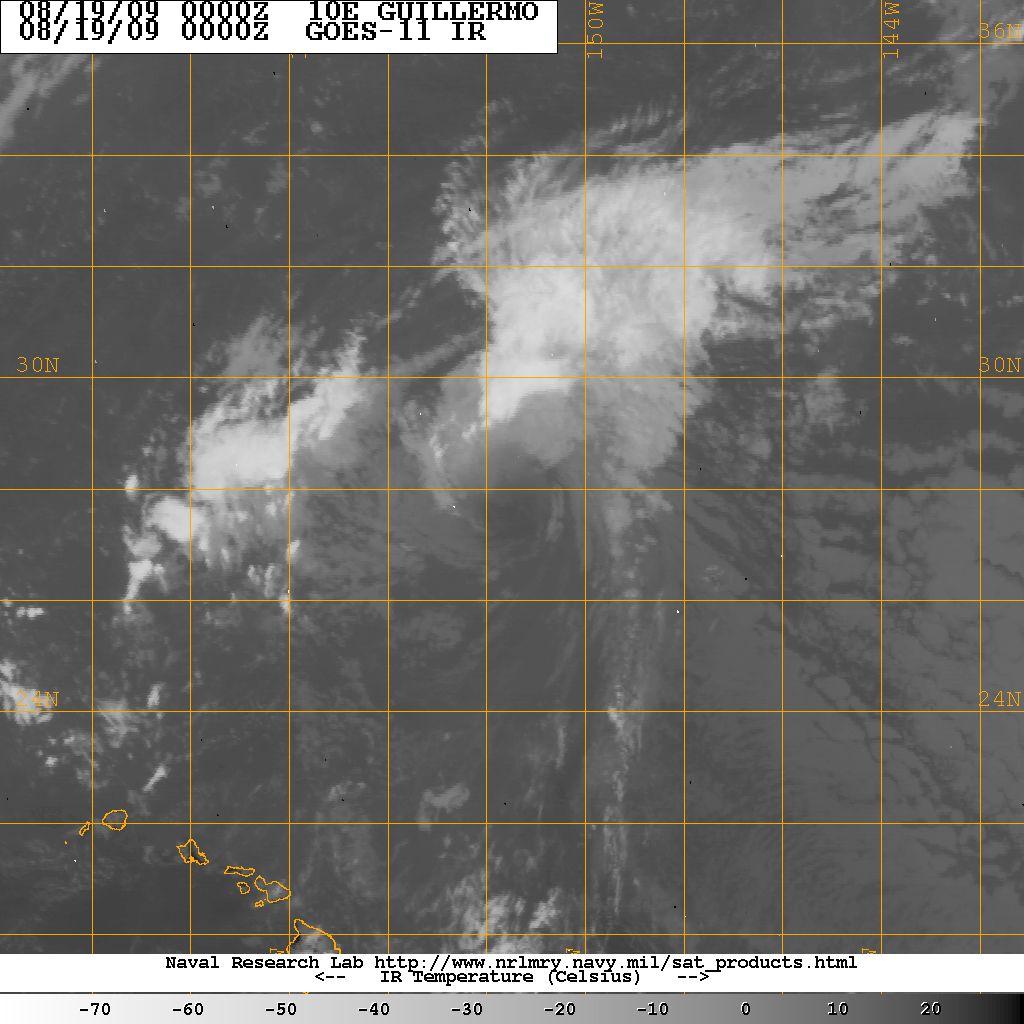
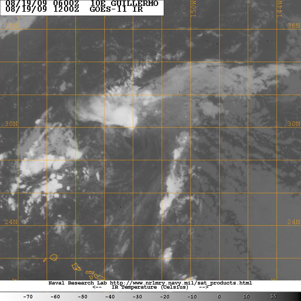
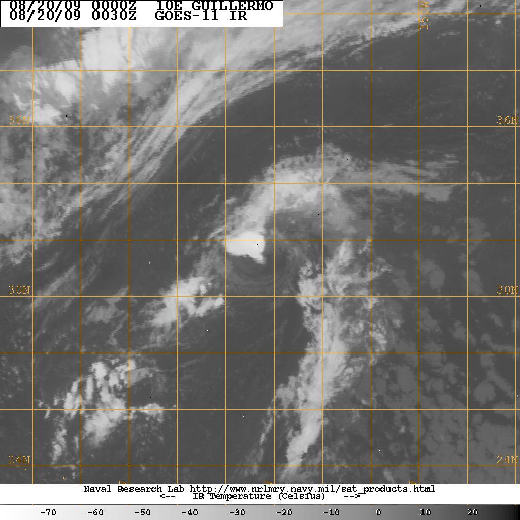
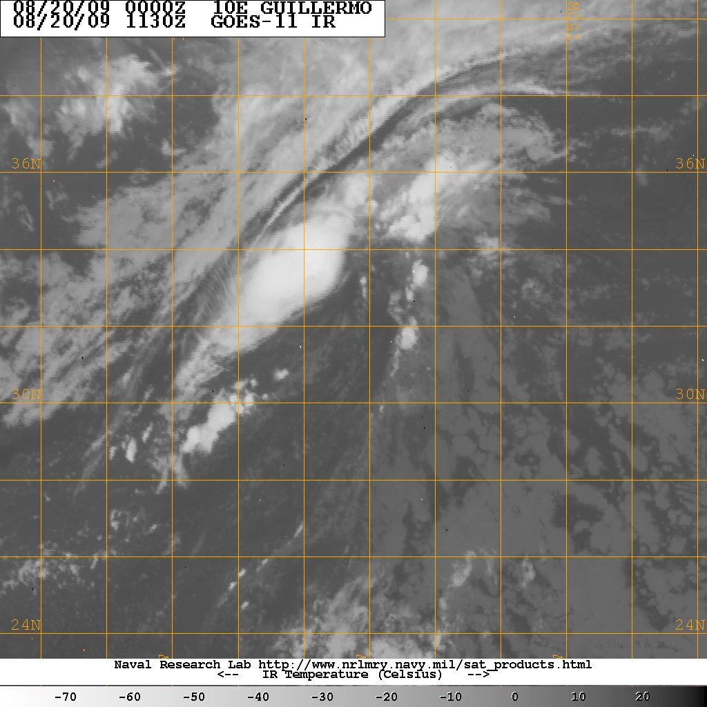
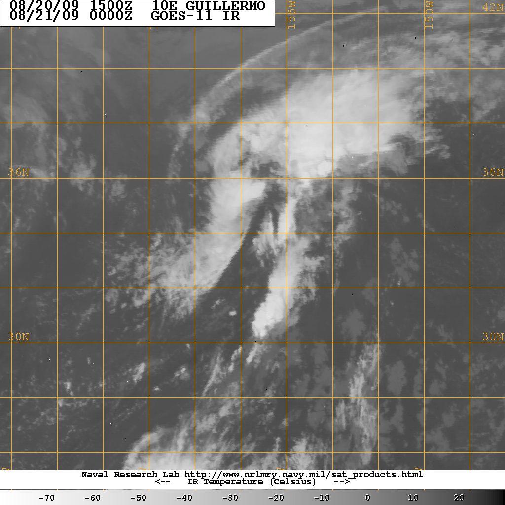
12 Hurricane Guillermo 2009

13 Hurricane Guillermo 2009

14 Hurricane Guillermo mb

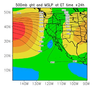
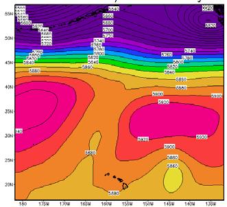
15 Hurricane Guillermo hPa Geopotential heights & SLP (shaded < 1008) Aug Z Aug Z Aug Z Aug Z Aug Z Aug Z


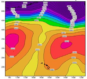
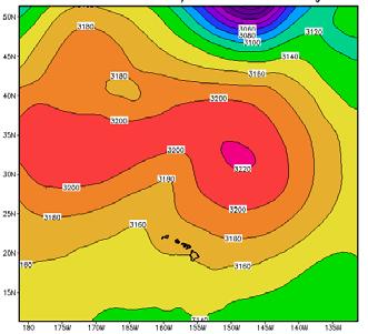
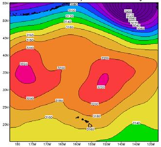
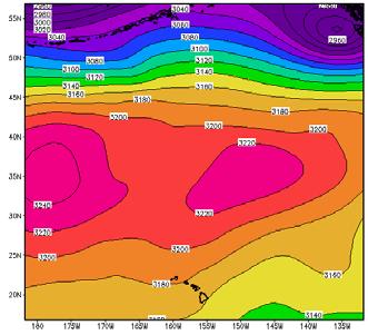
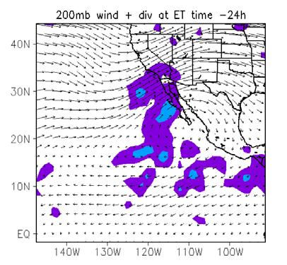
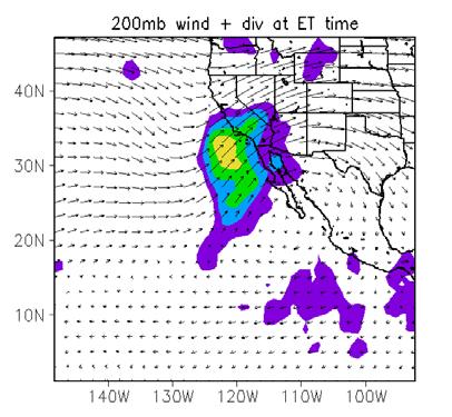
16 Hurricane Guillermo /00Z 21/00Z 22/00Z 400 hpa 500 hpa 700 hpa


17 Hurricane Guillermo 2009

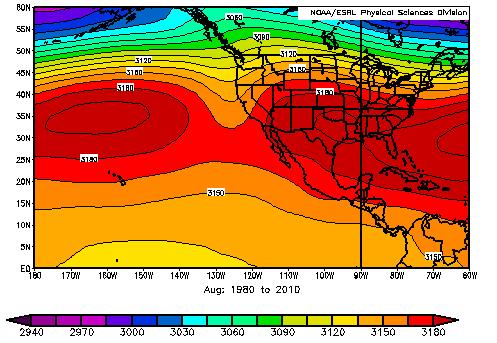
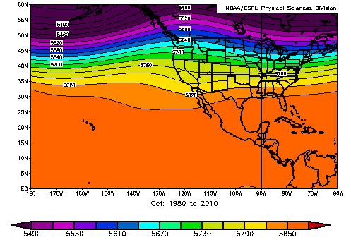
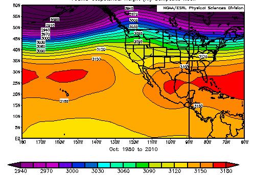
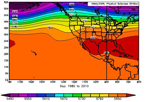
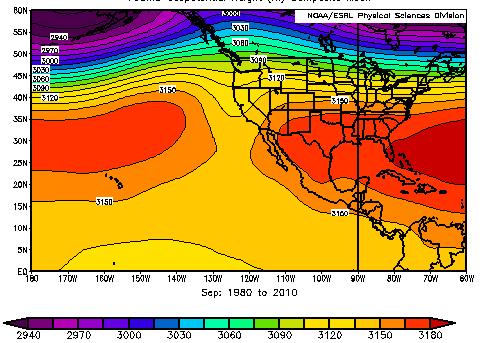
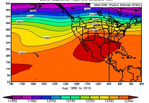
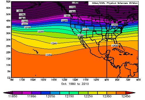
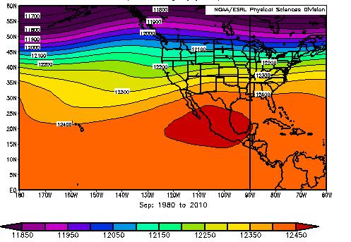
18 Mean Fields ( ) August September October 200 hpa 500 hpa 700 hpa


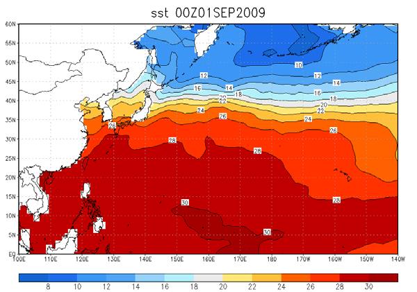
19 SST fields September 2009
20 First Summary Continued discussion of ET in the eastern North Pacific Structural characteristics of ET are difficult to extract because of the dominance of the structure of the large-scale circulation pattern PV cross-sections indicate confinement of positive PV to upper levels of the atmosphere possibly due to presence of very strong and deep subtropical ridge in lower atmosphere. masks any low-level circulation development that would be captured in the area-averaged PV fields Continue to analyze structural characteristics using NOGAPS analyses find other ways to characterize the low-level structure Extend all tracks to at least 72 h past ET time using 700-hPa vorticity and other indicators of low-level circulation.
21 Predicting ET outcome Dominantly a two-phase process (Klein et al., 2000) Transformation phase Re-intensification phase (Demirci et al. 2007) (Felker et al. 2011) Individual storms often classified as Intensifiers or Dissipaters (e.g. Demirci et al., 2007; Kofron et al., 2010) Difficult to distinguish differences in storm structure of Intensifiers and Dissipaters during phase 1 (transformation) Spatial relationships between storms and the midlatitude environment can be used to differentiate Intensifiers and Dissipaters (Harr et al., 2000; Ritchie and Elsberry, 2007) Here we use these differences in mid-latitude spatial patterns to predict post-extratropical transition outcomes
 Intensifier if central surface pressure of storm dropped more than 3mb between ET +/- 6 hours and ET+54 +/- 18 hours Otherwise classified as dissipater Resulted in 53 intensifiers and 55")
22 Predicting ET outcome Classifying Storms: Intensifier 108 West Pacific storms from 2000 through 2008 ET time defined as when storm becomes open wave at 500mb at 20m contour level (as in Demirci et al., 2007) Intensifier if central surface pressure of storm dropped more than 3mb between ET +/- 6 hours and ET+54 +/- 18 hours Otherwise classified as dissipater Resulted in 53 intensifiers and 55 dissipaters overall ET-72 Dissipater ET ET+72
23 Surface Pressure Evolution Means
![Classifying Storms - SVM Use 850-hPa potential temperature FNL analyses, 60 latitude x 50 longitude centered on TC center (3111 data points [features] per time frame) Data at 6 hour intervals from 72](/docs-images/93/111343887/images/24-2.jpg "hours before ET to 72 hours after ET Number of features reduced to 20 using Correlation-based Feature Selection (CFS) method (Hall, 1999) to prevent overtraining Features are those selected as")
24 Classifying Storms - SVM Use 850-hPa potential temperature FNL analyses, 60 latitude x 50 longitude centered on TC center (3111 data points [features] per time frame) Data at 6 hour intervals from 72 hours before ET to 72 hours after ET Number of features reduced to 20 using Correlation-based Feature Selection (CFS) method (Hall, 1999) to prevent overtraining Features are those selected as discriminating the two classes of ET Chosen features are shown in white: Around the TC Deep in midlatitude trough
25 Classifying Storms - SVM Use 20 selected features at each relative ET time as SVM inputs Iterate through SVM parameters and use K-fold cross validation on testing set (80%) to choose the best set of parameters for generalization Re-run SVM on test set (20%) using established parameters to get true system performance
26 Classifying SVM Performance ET-72 ET-48 ET-24 ET ET+24 ET+48
27 Project Overview Over 75% (17 out of 21) of test storms were correctly classified at 72 hours prior to ET ( 3 dissipaters and 1 intensifier were misclassified) Features of the upstream trough were found to be especially influential in classifying storms as intensifiers or dissipaters Classification performance tends to decrease as ET time approaches, suggesting that storms exhibit very similar spatial patterns right before the transition process


28 Thank you
2D.1 DETERMINATION OF A CONSISTENT TIME FOR THE EXTRATROPICAL TRANSITION OF TROPICAL CYCLONES
 2D.1 DETERMINATION OF A CONSISTENT TIME FOR THE EXTRATROPICAL TRANSITION OF TROPICAL CYCLONES David E. Kofron*, Elizabeth A. Ritchie, and J. Scott Tyo University of Arizona, Tucson, Arizona 1. INTRODUCTION
David E. Kofron*, Miguel F. Piñeros, Elizabeth A. Ritchie, and J. Scott Tyo University of Arizona, Tucson, Arizona 1. INTRODUCTION
 15.4 DEFINING THE LIFECYCLE OF THE EXTRATROPICAL TRANSITION OF TROPICAL CYCLONES USING THE DEVIATION ANGLE VARIANCE TECHNIQUE FOR REMOTELY-SENSED IMAGERY David E. Kofron*, Miguel F. Piñeros, Elizabeth
The Impact of air-sea interaction on the extratropical transition of tropical cyclones
 The Impact of air-sea interaction on the extratropical transition of tropical cyclones Sarah Jones Institut für Meteorologie und Klimaforschung Universität Karlsruhe / Forschungszentrum Karlsruhe 1. Introduction
THE EXTRATROPICAL TRANSITION OF TYPHOON WINNIE (1997): SELF-AMPLIFICATION AFTER LANDFALL
: SELF-AMPLIFICATION AFTER LANDFALL") THE EXTRATROPICAL TRANSITION OF TYPHOON WINNIE (1997): SELF-AMPLIFICATION AFTER LANDFALL Chih-Shin Liu *1,2 and George Tai-Jen Chen 2 1 Weather Forecast Center, Central Weather Bureau, 2 Department of
THE EXTRATROPICAL TRANSITION OF TYPHOON WINNIE (1997): SELF-AMPLIFICATION AFTER LANDFALL Chih-Shin Liu *1,2 and George Tai-Jen Chen 2 1 Weather Forecast Center, Central Weather Bureau, 2 Department of
Tropical Cyclone Formation/Structure/Motion Studies
 Tropical Cyclone Formation/Structure/Motion Studies Patrick A. Harr Department of Meteorology Naval Postgraduate School Monterey, CA 93943-5114 phone: (831) 656-3787 fax: (831) 656-3061 email: paharr@nps.edu
Simulations of the Extratropical Transition of Tropical Cyclones: Phasing between the Upper-Level Trough and Tropical Cyclones
 862 M O N T H L Y W E A T H E R R E V I E W VOLUME 135 Simulations of the Extratropical Transition of Tropical Cyclones: Phasing between the Upper-Level Trough and Tropical Cyclones ELIZABETH A. RITCHIE
1. INTRODUCTION: 2. DATA AND METHODOLOGY:
 27th Conference on Hurricanes and Tropical Meteorology, 24-28 April 2006, Monterey, CA 3A.4 SUPERTYPHOON DALE (1996): A REMARKABLE STORM FROM BIRTH THROUGH EXTRATROPICAL TRANSITION TO EXPLOSIVE REINTENSIFICATION
Impact of air-sea interaction on extratropical transition of tropical cyclones. Sarah Jones
 Impact of air-sea interaction on extratropical transition of tropical cyclones Sarah Jones 12.Juli 2007 15.Juli 2007 16.Juli 2007 Direct Impact of ET Ex-Hurricane Philippe: a storm or not a storm? 6 day
The 2009 Hurricane Season Overview
 The 2009 Hurricane Season Overview Jae-Kyung Schemm Gerry Bell Climate Prediction Center NOAA/ NWS/ NCEP 1 Overview outline 1. Current status for the Atlantic, Eastern Pacific and Western Pacific basins
Subtropical and Hybrid Systems IWTC VII Topic 1.6
 Subtropical and Hybrid Systems IWTC VII Topic 1.6 John R. Gyakum Department of Atmospheric and Oceanic Sciences McGill University, Montreal Canada Working group: John L. Beven II, Lance F. Bosart, Fermin
Extratropical transition of tropical cyclones: Operational forecasting challenges. Matthew Kucas Joint Typhoon Warning Center Pearl Harbor, HI, USA
 Extratropical transition of tropical cyclones: Operational forecasting challenges Matthew Kucas Joint Typhoon Warning Center Pearl Harbor, HI, USA Outline Motivation for discussion Brief overview of tropical
The Extratropical Transition of Tropical Cyclones
 The Extratropical Transition of Tropical Cyclones Elizabeth A. Ritchie Department of Electrical and Computer Engineering and the Center for High Performance Computing Room 125, EECE Building Albuquerque,
Julia H. Keller¹, Sarah C. Jones¹ and Patrick A. Harr²
 The Eddy Kinetic Energy Budget for Several Forecast Scenarios of the Extratropical Transition of two Tropical Cyclones Julia H. Keller¹, Sarah C. Jones¹ and Patrick A. Harr² ¹ Karlsruhe Institute of Technology
Simulations of the Extratropical Transition of Tropical Cyclones: Contributions by the Midlatitude Upper-Level Trough to Reintensification
 2112 MONTHLY WEATHER REVIEW Simulations of the Extratropical Transition of Tropical Cyclones: Contributions by the Midlatitude Upper-Level Trough to Reintensification ELIZABETH A. RITCHIE Department of
A Preliminary Climatology of Extratropical Transitions in the Southwest Indian Ocean
 A Preliminary Climatology of Extratropical Transitions in the Southwest Indian Ocean Kyle S. Griffin Department of Atmospheric and Environmental Sciences, University at Albany, State University of New
P2.4 THE IMPACT OF TROPICAL CYCLONE REMNANTS ON THE RAINFALL OF THE NORTH AMERICAN SOUTHWEST REGION
 P2.4 THE IMPACT OF TROPICAL CYCLONE REMNANTS ON THE RAINFALL OF THE NORTH AMERICAN SOUTHWEST REGION by Elizabeth A. Ritchie 1 and David Szenasi University of New Mexico 1. INTRODUCTION New Mexico has a
Synoptic Meteorology
 M.Sc. in Meteorology Synoptic Meteorology [MAPH P312] Prof Peter Lynch Second Semester, 2004 2005 Seminar Room Dept. of Maths. Physics, UCD, Belfield. Part 9 Extratropical Weather Systems These lectures
Extratropical transition of North Atlantic tropical cyclones in variable-resolution CAM5
 Extratropical transition of North Atlantic tropical cyclones in variable-resolution CAM5 Diana Thatcher, Christiane Jablonowski University of Michigan Colin Zarzycki National Center for Atmospheric Research
A Climatology of the Extratropical Transition of Tropical Cyclones in the Western North Pacific
 A Climatology of the Extratropical Transition of Tropical Cyclones in the Western North Pacific Naoko KITABATAKE (Meteorological Research Institute / Japan Meteorological Agency) 1 Outline 1. Topic 1:
Lower-Tropospheric Height Tendencies Associated with the Shearwise and Transverse Components of Quasigeostrophic Vertical Motion
 JULY 2007 N O T E S A N D C O R R E S P O N D E N C E 2803 Lower-Tropospheric Height Tendencies Associated with the Shearwise and Transverse Components of Quasigeostrophic Vertical Motion JONATHAN E. MARTIN
Multiscale Analyses of Inland Tropical Cyclone Midlatitude Jet Interactions: Camille (1969) and Danny (1997)
 and Danny (1997)") Multiscale Analyses of Inland Tropical Cyclone Midlatitude Jet Interactions: Camille (1969) and Danny (1997) Matthew Potter, Lance Bosart, and Daniel Keyser Department of Atmospheric and Environmental
Multiscale Analyses of Inland Tropical Cyclone Midlatitude Jet Interactions: Camille (1969) and Danny (1997) Matthew Potter, Lance Bosart, and Daniel Keyser Department of Atmospheric and Environmental
PATRICK A. HARR. Department of Meteorology, Naval Postgraduate School, Monterey, California
 VOLUME 136 M O N T H L Y W E A T H E R R E V I E W SEPTEMBER 2008 Predictability Associated with the Downstream Impacts of the Extratropical Transition of Tropical Cyclones: Methodology and a Case Study
TOWARDS A BETTER UNDERSTANDING OF AND ABILITY TO FORECAST THE WIND FIELD EXPANSION DURING THE EXTRATROPICAL TRANSITION PROCESS
 P1.17 TOWARDS A BETTER UNDERSTANDING OF AND ABILITY TO FORECAST THE WIND FIELD EXPANSION DURING THE EXTRATROPICAL TRANSITION PROCESS Clark Evans* and Robert E. Hart Florida State University Department
13.3 CHARACTERIZATION OF EXTRATROPICAL TRANSITION USING CLUSTER ANALYSIS
 13.3 CHARACTERIZATION OF EXTRATROPICA TRANSITION USING CUSTER ANAYSIS Justin M. Arnott* and Jenni. Evans The Pennsylvania State University, Department of Meteorology, University Park, Pennsylvania 1. INTRODUCTION
Tropical Cyclone Intensity and Structure Changes in relation to Tropical Cyclone Outflow
 DISTRIBUTION STATEMENT A. Approved for public release; distribution is unlimited. Tropical Cyclone Intensity and Structure Changes in relation to Tropical Cyclone Outflow Patrick A. Harr Department of
1. INTRODUCTION. designed. The primary focus of this strategy was the extratropical transition (ET) of tropical cyclones based on the poleward
 of tropical cyclones based on the poleward") P1.98 THE THORPEX PACIFIC ASIAN REGIONAL CAMPAIGN (T-PARC) OBJECTIVE ON THE EXTRATROPICAL TRANSITION OF TROPICAL CYCLONES: OBSERVED CASES, THEIR STRUCTURE AND DOWNSTREAM IMPACTS P. A. Harr 1, S. C. Jones
P1.98 THE THORPEX PACIFIC ASIAN REGIONAL CAMPAIGN (T-PARC) OBJECTIVE ON THE EXTRATROPICAL TRANSITION OF TROPICAL CYCLONES: OBSERVED CASES, THEIR STRUCTURE AND DOWNSTREAM IMPACTS P. A. Harr 1, S. C. Jones
Predecessor Rain Events: A Literature Review. By: Tony Viramontez
 Predecessor Rain Events: A Literature Review By: Tony Viramontez Introduction Predecessor Rain Event (PRE): meso- and subsynopticscale regions of high-impact heavy rainfall that occur well in advance of
The Extratropical Transition of Tropical Cyclone Lili (1996) and Its Crucial Contribution to a Moderate Extratropical Development
 and Its Crucial Contribution to a Moderate Extratropical Development") 1562 M O N T H L Y W E A T H E R R E V I E W VOLUME 133 The Extratropical Transition of Tropical Cyclone Lili (1996) and Its Crucial Contribution to a Moderate Extratropical Development ANNA AGUSTÍ-PANAREDA
1562 M O N T H L Y W E A T H E R R E V I E W VOLUME 133 The Extratropical Transition of Tropical Cyclone Lili (1996) and Its Crucial Contribution to a Moderate Extratropical Development ANNA AGUSTÍ-PANAREDA
The Impact of the Extratropical Transition of Typhoon Dale (1996) on the Early Wintertime Stratospheric Circulation
 on the Early Wintertime Stratospheric Circulation") The Impact of the Extratropical Transition of Typhoon Dale (1996) on the Early 1996-97 Wintertime Stratospheric Circulation Andrea L. Lang 1, Jason M. Cordeira 2, Lance F. Bosart 1 and Daniel Keyser 1
The Impact of the Extratropical Transition of Typhoon Dale (1996) on the Early 1996-97 Wintertime Stratospheric Circulation Andrea L. Lang 1, Jason M. Cordeira 2, Lance F. Bosart 1 and Daniel Keyser 1
Examination of Tropical Cyclogenesis using the High Temporal and Spatial Resolution JRA-25 Dataset
 Examination of Tropical Cyclogenesis using the High Temporal and Spatial Resolution JRA-25 Dataset Masato Sugi Forecast Research Department, Meteorological Research Institute, Japan Correspondence: msugi@mri-jma.go.jp
10B.2 THE ROLE OF THE OCCLUSION PROCESS IN THE EXTRATROPICAL-TO-TROPICAL TRANSITION OF ATLANTIC HURRICANE KAREN
 10B.2 THE ROLE OF THE OCCLUSION PROCESS IN THE EXTRATROPICAL-TO-TROPICAL TRANSITION OF ATLANTIC HURRICANE KAREN Andrew L. Hulme* and Jonathan E. Martin University of Wisconsin-Madison, Madison, Wisconsin
What does a cloud-resolving model bring during an extratropical transition?
 What does a cloud-resolving model bring during an extratropical transition? Florian Pantillon (1) Jean-Pierre Chaboureau (1) Christine Lac (2) Patrick Mascart (1) (1) Laboratoire d'aérologie, Toulouse,
Tropical Cyclone Genesis: What we know, and what we don t!
 Tropical Cyclone Genesis: What we know, and what we don t! Allison Wing! NSF Postdoctoral Research Fellow! Lamont-Doherty Earth Observatory! Columbia University! Overview! Climatology! What We Know! Theories!
Using satellite-based remotely-sensed data to determine tropical cyclone size and structure characteristics
 DISTRIBUTION STATEMENT A. Approved for public release; distribution is unlimited. Using satellite-based remotely-sensed data to determine tropical cyclone size and structure characteristics PI: Elizabeth
Synoptic Composites of the Extratropical Transition Life Cycle of North Atlantic Tropical Cyclones: Factors Determining Posttransition Evolution
 FEBRUARY 2006 H A R T E T A L. 553 Synoptic Composites of the Extratropical Transition Life Cycle of North Atlantic Tropical Cyclones: Factors Determining Posttransition Evolution ROBERT E. HART Department
Sciences Research and Development. 805 Sherbrooke Street West Frankfurter Str Working group:
 Advances in Understanding Extratropical John R. Gyakum Transition (ET) IWTC-VIII Topic 4.2 Julia Keller Department of Atmospheric and Oceanic Deutscher Wetterdienst Sciences Research and Development McGill
Tropical Cyclone Data Impact Studies: Influence of Model Bias and Synthetic Observations
 Tropical Cyclone Data Impact Studies: Influence of Model Bias and Synthetic Observations C. Reynolds, R. Langland and P. Pauley, Naval Research Laboratory, Marine Meteorology Division, Monterey, CA C.
Tropical-Extratropical Transition
 Tropical-Extratropical Transition Extratropical Transition A significant number of tropical cyclones move into the midlatitudes and transform into extratropical cyclones. This process is generally referred
6A.4 ASYMMETRIC STRUCTURE and MAINTENANCE in HURRICANE JUAN. Weiqing Zhang 1,2, William Perrie* 1,2
 6A.4 ASYMMETRIC STRUCTURE and MAINTENANCE in HURRICANE JUAN Weiqing Zhang 1,2, William Perrie* 1,2 1 Fisheries & Oceans Canada, Bedford Institute of Oceanography, Dartmouth, Canada 2 Dept. Engineering
High-Resolution MPAS Simulations for Analysis of Climate Change Effects on Weather Extremes
 High-Resolution MPAS Simulations for Analysis of Climate Change Effects on Weather Extremes ALLISON MICHAELIS, GARY LACKMANN, & WALT ROBINSON Department of Marine, Earth, and Atmospheric Sciences, North
Stephen W. Bieda III, Steven L. Mullen, Christopher L. Castro University of Arizona Department of Atmospheric Sciences
 Stephen W. Bieda III, Steven L. Mullen, Christopher L. Castro University of Arizona Department of Atmospheric Sciences Collaborative effort between National Weather Service, Tucson, AZ WSFO and the University
Understanding the Microphysical Properties of Developing Cloud Clusters during TCS-08
 DISTRIBUTION STATEMENT A: Approved for public release; distribution is unlimited. Understanding the Microphysical Properties of Developing Cloud Clusters during TCS-08 PI: Elizabeth A. Ritchie Department
High-Impact Weather Events Associated with Interacting Tropical Cyclones over the Western Pacific in August 2016
 High-Impact Weather Events Associated with Interacting Tropical Cyclones over the Western Pacific in August 2016 Lance F. Bosart, Philippe P. Papin, and Alicia M. Bentley, and Tomer Burg GEWEX-2018 Open
General Circulation of the Atmosphere. René Garreaud
 General Circulation of the Atmosphere René Garreaud www.dgf.uchile.cl/rene General circulation of the Atmosphere Low latitude areas receive more solar energy than high latitudes (because of earth sphericity).
The purpose of this thesis is to present two multiscale analyses of inland tropical
 I. Introduction 1.1 General Purpose The purpose of this thesis is to present two multiscale analyses of inland tropical cyclone (TC) midlatitude jet interactions. More specifically, the main focus will
7 December 2016 Tokyo Climate Center, Japan Meteorological Agency
 Summary of the 2016 Asian Summer Monsoon 7 December 2016 Tokyo Climate Center, Japan Meteorological Agency This report summarizes the characteristics of the surface climate and atmospheric/oceanographic
The Impact of Oceanic Heat Content on the Rapid Intensification of Atlantic Hurricanes
 Marshall University Marshall Digital Scholar Geography Faculty Research Geography 1-1-2011 The Impact of Oceanic Heat Content on the Rapid Intensification of Atlantic Hurricanes Kevin Law Marshall University,
Description of the ET of Super Typhoon Choi-Wan (2009) based on the YOTC-dataset
 based on the YOTC-dataset") High Impact Weather PANDOWAE Description of the ET of Super Typhoon Choi-Wan (2009) based on the YOTC-dataset ¹, D. Anwender¹, S. C. Jones2, J. Keller2, L. Scheck¹ 2 ¹Karlsruhe Institute of Technology,
High Impact Weather PANDOWAE Description of the ET of Super Typhoon Choi-Wan (2009) based on the YOTC-dataset ¹, D. Anwender¹, S. C. Jones2, J. Keller2, L. Scheck¹ 2 ¹Karlsruhe Institute of Technology,
Forced and internal variability of tropical cyclone track density in the western North Pacific
 Forced and internal variability of tropical cyclone track density in the western North Pacific Wei Mei 1 Shang-Ping Xie 1, Ming Zhao 2 & Yuqing Wang 3 Climate Variability and Change and Paleoclimate Working
3A.6 HURRICANES IVAN, JEANNE, KARL (2004) AND MID-LATITUDE TROUGH INTERACTIONS
 AND MID-LATITUDE TROUGH INTERACTIONS") 27 th Conference on Hurricanes and Tropical Meteorology 24-28 April 2006, Monterey, CA 3A.6 HURRICANES IVAN, JEANNE, KARL (2004) AND MID-LATITUDE TROUGH INTERACTIONS Ryan N. Maue *, Melinda S. Peng, Carolyn
27 th Conference on Hurricanes and Tropical Meteorology 24-28 April 2006, Monterey, CA 3A.6 HURRICANES IVAN, JEANNE, KARL (2004) AND MID-LATITUDE TROUGH INTERACTIONS Ryan N. Maue *, Melinda S. Peng, Carolyn
The Unusual Behavior and Precipitation Pattern Associated with Tropical Storm Ignacio (1997)
") OCTOBER 2012 W O O D A N D R I T C H I E 3347 The Unusual Behavior and Precipitation Pattern Associated with Tropical Storm Ignacio (1997) KIMBERLY M. WOOD AND ELIZABETH A. RITCHIE Department of Atmospheric
OCTOBER 2012 W O O D A N D R I T C H I E 3347 The Unusual Behavior and Precipitation Pattern Associated with Tropical Storm Ignacio (1997) KIMBERLY M. WOOD AND ELIZABETH A. RITCHIE Department of Atmospheric
On African easterly waves that impacted two tropical cyclones in 2004
 GEOPHYSICAL RESEARCH LETTERS, VOL. 33,, doi:10.1029/2006gl026038, 2006 On African easterly waves that impacted two tropical cyclones in 2004 Melinda S. Peng, 1 Bing Fu, 2 Timothy F. Hogan, 1 and Tim Li
Lectures on Tropical Cyclones
 Lectures on Tropical Cyclones Chapter 1 Observations of Tropical Cyclones Outline of course Introduction, Observed Structure Dynamics of Mature Tropical Cyclones Equations of motion Primary circulation
Extratropical Transition of Western North Pacific Tropical Cyclones: An Overview and Conceptual Model of the Transformation Stage
 VOLUME 15 WEATHER AND FORECASTING AUGUST 2000 Extratropical Transition of Western North Pacific Tropical Cyclones: An Overview and Conceptual Model of the Transformation Stage PETER M. KLEIN, PATRICK A.
1. Introduction. 2. Verification of the 2010 forecasts. Research Brief 2011/ February 2011
 Research Brief 2011/01 Verification of Forecasts of Tropical Cyclone Activity over the Western North Pacific and Number of Tropical Cyclones Making Landfall in South China and the Korea and Japan region
Divergence, Spin, and Tilt. Convergence and Divergence. Midlatitude Cyclones. Large-Scale Setting
 Midlatitude Cyclones Equator-to-pole temperature gradient tilts pressure surfaces and produces westerly jets in midlatitudes Waves in the jet induce divergence and convergence aloft, leading to surface
Climate Forecast Applications Network (CFAN)
") Forecast of 2018 Atlantic Hurricane Activity April 5, 2018 Summary CFAN s inaugural April seasonal forecast for Atlantic tropical cyclone activity is based on systematic interactions among ENSO, stratospheric
Forecast of 2018 Atlantic Hurricane Activity April 5, 2018 Summary CFAN s inaugural April seasonal forecast for Atlantic tropical cyclone activity is based on systematic interactions among ENSO, stratospheric
DYNAMICAL STRUCTURES AND PRECIPITATION DISTRIBUTIONS OF TRANSITIONING TROPICAL CYCLONES IN EASTERN CANADA,
 6B.1 DYNAMICAL STRUCTURES AND PRECIPITATION DISTRIBUTIONS OF TRANSITIONING TROPICAL CYCLONES IN EASTERN CANADA, 1979-2004 SHAWN MILRAD 1, EYAD ATALLAH and JOHN GYAKUM Department of Atmospheric and Oceanic
COLORADO STATE UNIVERSITY FORECAST OF ATLANTIC HURRICANE ACTIVITY FROM AUGUST 16 29, 2018
 COLORADO STATE UNIVERSITY FORECAST OF ATLANTIC HURRICANE ACTIVITY FROM AUGUST 16 29, 2018 We expect that the next two weeks will be characterized by below-normal amounts of hurricane activity. (as of 16
16C.6 Genesis of Atlantic tropical storms from African Easterly Waves a comparison of two contrasting years
 16C.6 Genesis of Atlantic tropical storms from African Easterly Waves a comparison of two contrasting years Susanna Hopsch 1 Department of Earth and Atmospheric Sciences, University at Albany, Albany,
3. Midlatitude Storm Tracks and the North Atlantic Oscillation
 3. Midlatitude Storm Tracks and the North Atlantic Oscillation Copyright 2006 Emily Shuckburgh, University of Cambridge. Not to be quoted or reproduced without permission. EFS 3/1 Review of key results
Lec 10: Interpreting Weather Maps
 Lec 10: Interpreting Weather Maps Case Study: October 2011 Nor easter FIU MET 3502 Synoptic Hurricane Forecasts Genesis: on large scale weather maps or satellite images, look for tropical waves (Africa
THE PHYSICAL processes associated with tropical cyclone
 826 IEEE GEOSCIENCE AND REMOTE SENSING LETTERS, VOL. 7, NO. 4, OCTOBER 2010 Detecting Tropical Cyclone Genesis From Remotely Sensed Infrared Image Data Miguel F. Piñeros, Elizabeth A. Ritchie, and J. Scott
Chapter 1 Anatomy of a Cyclone
 Chapter 1 Anatomy of a Cyclone The Beast in the East 15-17 February 2003 Extra-tropical cyclone an area of low pressure outside of the tropics Other names for extra-tropical cyclones: Cyclone Mid-latitude
Tri-Agency Forecast Discussion for August 24, 2010
 Created 1600 UTC August 24, 2010 Tri-Agency Forecast Discussion for August 24, 2010 GRIP Forecast Team: Cerese Inglish, Matt Janiga, Andrew Martin, Dan Halperin, Jon Zawislak, Ellen Ramirez, Amber Reynolds,
A Statistical-Dynamical Seasonal Forecast of US Landfalling TC Activity
 A Statistical-Dynamical Seasonal Forecast of US Landfalling TC Activity Johnny Chan and Samson K S Chiu Guy Carpenter Asia-Pacific Climate Impact Centre City University of Hong Kong Research sponsored
Why the Atlantic was surprisingly quiet in 2013
 1 Why the Atlantic was surprisingly quiet in 2013 by William Gray and Phil Klotzbach Preliminary Draft - March 2014 (Final draft by early June) ABSTRACT This paper discusses the causes of the unusual dearth
COLORADO STATE UNIVERSITY FORECAST OF ATLANTIC HURRICANE ACTIVITY FROM SEPTEMBER 27-OCTOBER 10, 2018
 COLORADO STATE UNIVERSITY FORECAST OF ATLANTIC HURRICANE ACTIVITY FROM SEPTEMBER 27-OCTOBER 10, 2018 We expect that the next two weeks will be characterized by above-normal amounts of hurricane activity,
NHC Ensemble/Probabilistic Guidance Products
 NHC Ensemble/Probabilistic Guidance Products Michael Brennan NOAA/NWS/NCEP/NHC Mark DeMaria NESDIS/STAR HFIP Ensemble Product Development Workshop 21 April 2010 Boulder, CO 1 Current Ensemble/Probability
Large-Scale Flow Patterns and Their Influence on the Intensification Rates of Western North Pacific Tropical Storms*
 1110 M O N T H L Y W E A T H E R R E V I E W VOLUME 135 Large-Scale Flow Patterns and Their Influence on the Intensification Rates of Western North Pacific Tropical Storms* JUSTIN D. VENTHAM AND BIN WANG
An Observational Study of Environmental Influences on the Intensity Changes of Typhoons Flo (1990) and Gene (1990)
 and Gene (1990)") 3003 An Observational Study of Environmental Influences on the Intensity Changes of Typhoons Flo (1990) and Gene (1990) CHUN-CHIEH WU ANDHSIU-JU CHENG Department of Atmospheric Sciences, National Taiwan
3003 An Observational Study of Environmental Influences on the Intensity Changes of Typhoons Flo (1990) and Gene (1990) CHUN-CHIEH WU ANDHSIU-JU CHENG Department of Atmospheric Sciences, National Taiwan
Recurving Western North Pacific Tropical Cyclones and Mid-Latitude Predictability
 GEOPHYSICAL RESEARCH LETTERS, VOL.???, XXXX, DOI:10.1002/, 1 2 Recurving Western North Pacific Tropical Cyclones and Mid-Latitude Predictability A. Aiyyer, 1 Corresponding author: A. Aiyyer, Department
Diabatic processes and the structure of extratropical cyclones
 Geophysical and Nonlinear Fluid Dynamics Seminar AOPP, Oxford, 23 October 2012 Diabatic processes and the structure of extratropical cyclones Oscar Martínez-Alvarado R. Plant, J. Chagnon, S. Gray, J. Methven
Satellites, Weather and Climate Module??: Polar Vortex
 Satellites, Weather and Climate Module??: Polar Vortex SWAC Jan 2014 AKA Circumpolar Vortex Science or Hype? Will there be one this year? Today s objectives Pre and Post exams What is the Polar Vortex
Mélicie Desflots* RSMAS, University of Miami, Miami, Florida
 15B.6 RAPID INTENSITY CHANGE IN HURRICANE LILI (2002) Mélicie Desflots* RSMAS, University of Miami, Miami, Florida 1. INTRODUCTION Rapid intensity change in tropical cyclones is one of the most difficult
Improving our Understanding of Tropical Cyclone Genesis
 DISTRIBUTION STATEMENT A: Distribution approved for public release; distribution is unlimited. Improving our Understanding of Tropical Cyclone Genesis Elizabeth A. Ritchie Department of Atmospheric Sciences
C
 C 0.8 0.4 0.2 0.0-0.2-0.6 Fig. 1. SST-wind relation in the North Pacific and Atlantic Oceans. Left panel: COADS SST (color shade), surface wind vectors, and SLP regressed upon the Pacific Decadal Oscillation
NAVAL POSTGRADUATE SCHOOL Monterey, California THESIS EXTRATROPICAL TRANSITION OF WESTERN NORTH PACIFIC TROPICAL CYCLONES. Peter M.
 NAVAL POSTGRADUATE SCHOOL Monterey, California THESIS */7 QU EXTRATROPICAL TRANSITION OF WESTERN NORTH PACIFIC TROPICAL CYCLONES by Peter M. Klein September, 1997 Thesis Co-Advisors: Russell L. Elsberry
The 2009 Hurricane Season in the Eastern North Pacific Basin: An Analysis of Environmental Conditions
 JUNE 2011 C O L L I N S A N D R O A C H E 1673 The 2009 Hurricane Season in the Eastern North Pacific Basin: An Analysis of Environmental Conditions JENNIFER M. COLLINS AND DAVID R. ROACHE Department of
Understanding the Microphysical Properties of Developing Cloud Clusters During TCS-08
 Understanding the Microphysical Properties of Developing Cloud Clusters During TCS-08 PI: Elizabeth A. Ritchie Department of Atmospheric Sciences, University of Arizona Room 542, Physics-Atmospheric Sciences
Analysis of Fall Transition Season (Sept-Early Dec) Why has the weather been so violent?
 Why has the weather been so violent?") WEATHER TOPICS Analysis of Fall Transition Season (Sept-Early Dec) 2009 Why has the weather been so violent? As can be seen by the following forecast map, the Fall Transition and early Winter Season of
WEATHER TOPICS Analysis of Fall Transition Season (Sept-Early Dec) 2009 Why has the weather been so violent? As can be seen by the following forecast map, the Fall Transition and early Winter Season of
2D.4 THE STRUCTURE AND SENSITIVITY OF SINGULAR VECTORS ASSOCIATED WITH EXTRATROPICAL TRANSITION OF TROPICAL CYCLONES
 2D.4 THE STRUCTURE AND SENSITIVITY OF SINGULAR VECTORS ASSOCIATED WITH EXTRATROPICAL TRANSITION OF TROPICAL CYCLONES Simon T. Lang Karlsruhe Institute of Technology. INTRODUCTION During the extratropical
Remote impact of North Atlantic hurricanes on the Mediterranean during episodes of intense rainfall in autumn 2012
 QuarterlyJournalof theroyalmeteorologicalsociety Q. J. R. Meteorol. Soc. 141: 967 978, April 2015 A DOI:10.1002/qj.2419 Remote impact of North Atlantic hurricanes on the Mediterranean during episodes of
Vertical structure. To conclude, we will review the critical factors invloved in the development of extratropical storms.
 Vertical structure Now we will examine the vertical structure of the intense baroclinic wave using three visualization tools: Upper level charts at selected pressure levels Vertical soundings for selected
COLORADO STATE UNIVERSITY FORECAST OF ATLANTIC HURRICANE ACTIVITY FROM SEPTEMBER 1 SEPTEMBER 14, 2015
 COLORADO STATE UNIVERSITY FORECAST OF ATLANTIC HURRICANE ACTIVITY FROM SEPTEMBER 1 SEPTEMBER 14, 2015 We expect that the next two weeks will be characterized by below-average amounts (
Synoptic Meteorology II: Self-Development in the IPV Framework. 5-7 May 2015
 Synoptic Meteorology II: Self-Development in the IPV Framework 5-7 May 2015 Readings: Section 5.3.6 of Midlatitude Synoptic Meteorology. Introduction In this and other recent lectures, we have developed
2015/16 Winter Monsoon in East Asia
 8 Apr 2016, FOCRAII-12, Guangzhou, China 2015/16 Winter Monsoon in East Asia Hirotaka SATO Tokyo Climate Center Japan Meteorological Agency 1 Outline 1. Overview of 2015/16 winter monsoon in East Asia
Calhoun: The NPS Institutional Archive
 Calhoun: The NPS Institutional Archive Faculty and Researcher Pulications Faculty and Researcher Pulications Collection 2008 The Relative Roles of Diaatic and Dynamic Processes in Downstream Development
Reprint 675. Variations of Tropical Cyclone Activity in the South China Sea. Y.K. Leung, M.C. Wu & W.L. Chang
 Reprint 675 Variations of Tropical Cyclone Activity in the South China Sea Y.K. Leung, M.C. Wu & W.L. Chang ESCAP/WMO Typhoon Committee Annual Review 25 Variations in Tropical Cyclone Activity in the South
COLORADO STATE UNIVERSITY FORECAST OF ATLANTIC HURRICANE ACTIVITY FROM OCTOBER 13 OCTOBER 26, 2017
 COLORADO STATE UNIVERSITY FORECAST OF ATLANTIC HURRICANE ACTIVITY FROM OCTOBER 13 OCTOBER 26, 2017 We expect that the next two weeks will be characterized by above-normal hurricane activity. (as of 13
Tropical Storms & Hurricanes Part 1. August 1992
 Lecture #16 (April 5, 2010, Monday) Tropical Storms & Hurricanes Part 1 August 1992 Tracks of rain accumulation & clouds from Hurricane Rita September 2005 Tropical Cyclones Around the Globe Why none here?
Ensemble Prediction Systems
 Ensemble Prediction Systems Eric Blake National Hurricane Center 7 March 2017 Acknowledgements to Michael Brennan 1 Question 1 What are some current advantages of using single-model ensembles? A. Estimates
SUPPLEMENTAL MATERIALS FOR:
 SUPPLEMENTAL MATERIALS FOR: Simulated reduction in Atlantic hurricane frequency under 21 st century warming conditions Thomas R. Knutson, Joseph J. Sirutis, Stephen T. Garner, Gabriel A. Vecchi, and Isaac
Climatology of dry air intrusions and their relation to strong surface winds in extratropical cyclones
 Climatology of dry air intrusions and their relation to strong surface winds in extratropical cyclones...and intro to synoptic and meso-scale cyclone dynamics Shira Raveh-Rubin and Heini Wernli Institute
COLORADO STATE UNIVERSITY FORECAST OF ATLANTIC HURRICANE ACTIVITY FROM SEPTEMBER 15 SEPTEMBER 28, 2015
 COLORADO STATE UNIVERSITY FORECAST OF ATLANTIC HURRICANE ACTIVITY FROM SEPTEMBER 15 SEPTEMBER 28, 2015 We expect that the next two weeks will be characterized by below-average amounts (
Comparison of Wave Packets associated with Extratropical. Transition and Winter Cyclones. Ryan D. Torn. Gregory J. Hakim
 Generated using version 3.1.2 of the official AMS L A TEX template 1 Comparison of Wave Packets associated with Extratropical 2 Transition and Winter Cyclones 3 Ryan D. Torn Department of Atmospheric and
The Impacts on Extended-Range Predictability of Midlatitude Weather Patterns due to Recurving Tropical Cyclones
 The Impacts on Extended-Range Predictability of Midlatitude Weather Patterns due to Recurving Tropical Cyclones Patrick A. Harr and Heather M. Archambault Naval Postgraduate School, Monterey, CA Hurricane
(April 7, 2010, Wednesday) Tropical Storms & Hurricanes Part 2
 Tropical Storms & Hurricanes Part 2") Lecture #17 (April 7, 2010, Wednesday) Tropical Storms & Hurricanes Part 2 Hurricane Katrina August 2005 All tropical cyclone tracks (1945-2006). Hurricane Formation While moving westward, tropical disturbances
Lecture #17 (April 7, 2010, Wednesday) Tropical Storms & Hurricanes Part 2 Hurricane Katrina August 2005 All tropical cyclone tracks (1945-2006). Hurricane Formation While moving westward, tropical disturbances
The Atmospheric Circulation
 The Atmospheric Circulation Vertical structure of the Atmosphere http://www.uwsp.edu/geo/faculty/ritter/geog101/textbook/atmosphere/atmospheric_structure.html The global heat engine [courtesy Kevin Trenberth,
Introduction of products for Climate System Monitoring
 Introduction of products for Climate System Monitoring 1 Typical flow of making one month forecast Textbook P.66 Observed data Atmospheric and Oceanic conditions Analysis Numerical model Ensemble forecast