Chapter 1. Introduction: What drives the ocean currents?
|
|
|
- Emil Townsend
- 5 years ago
- Views:
Transcription
1 Chapter 1 Introduction: What drives the ocean currents? Sixty years ago, this textbook would have been titled "Introductory Geography of the Oceans". Physical oceanography then was a close relative of physical geography and shared its descriptive character. This period culminated in textbooks such as Geographie des Atlantischen Ozeans (1912) and Geographie des Indischen und Stillen Ozeans (1935) by G. Schott, books which conveyed to the reader through a passioned yet accurate description of its features the fascination which the oceanic environment exerts on the oceanographer. Oceanography has come a long way since then, having concentrated on understanding the physical principles that drive the oceans and using the tools of mathematics and theoretical fluid dynamics to forecast their behaviour. Students of oceanography now spend more time trying to come to grips with vorticity, inverse methods and normal mode analysis than learning about the features of the deep sea basins and marginal seas or about the climatic regions of the oceans. And this is rightly so, for little is learned in science through mere description; analysis and conclusion are required before anyone can claim to understand. As it turns out, understanding the ocean circulation is impossible without knowledge of geographical details - the depth of certain ocean sills, for example, or the peculiarities of the wind field and its seasonal variation. To separate the facts about the geography of the ocean from acquired knowledge about its dynamics would be like separating the memorizing of the vocabulary of a new language from the learning of its grammar. What we propose to do is describe the features of the world ocean both as a systematic exercise in geography and as examples of physical principles at work. These physical principles are sufficiently powerful and all-pervasive that it is worth introducing them first. This and the following four chapters are a summary of some of the principles and their consequences, and will serve as a reference for all chapters to come. Students of oceanography who are using this book as their introduction to the discipline will find them essential reading. Advanced students who use the book because of a need to brush up their knowledge on the geography of the oceans can skip the first five chapters and go straight to the chapter of interest to them. Both should take particular notice of the figures which accompany the text. With a bit of guidance, much can be learnt by looking closely at observational data. Our text will provide the guidance, but it will not go into detailed descriptions of what can be seen more easily in figures. The figures are therefore not illustrations of the text; they are an integral part of this book. Some knowledge of the geography of the oceans is essential in regional oceanography. While we attempted to include as much relevant geographical information as possible, clarity of figures must rank higher than detail in an introductory text. Sometimes the location of a feature can be determined by consulting the index. In other cases the use of an elementary geographical atlas may be required. One final note on the use of geographic and oceanographic nomenclature, before some readers turn the page and proceed to other chapters. Although the use of geographical names and the rules on naming newly discovered geographic features are regulated by an international advisory body, use of geographical names in oceanography is not uniform. This is particularly true for features such as currents, fronts, or water masses, which are not covered by the international regulations on the use of geographical names. Oceanographers have an unfortunate habit of trying to make their mark by putting names to their liking on
2 features which

3 Introduction: What drives the ocean currents? 3 warm air at the equator; and since the air pressure at the sea surface or on land is determined by the weight of the air above the observation point, air pressure at sea level is higher at the poles than at the equator - in other words, a pressure gradient is set up which is directed from the poles toward the equator. The pressure gradient in the upper part of the atmosphere has the opposite sign. In fluids and gases, pressure gradients produce flow from regions of high pressure to regions of low pressure. If the earth were not rotating, the response to these pressure gradients would be direct and simple. Two circulation cells would be set up, one in either hemisphere, by the differential solar heating. At sea level, winds would blow from the poles to the equator; the air would then rise and recirculate back to the poles at great height. On a rotating earth this pattern is modified quite strongly, in two ways. Firstly, as air moves towards the equator, the rotation of the earth shifts ocean and land eastward under it. An observer moving with the land experiences the air movement as an "easterly" wind, i.e. a wind blowing from the east, with an equatorward component. In the tropics and subtropics this wind is known as the Trade Wind, in polar latitudes it occurs as the Polar Easterlies. The outcome is that the wind no longer blows from regions of high pressure to regions of low pressure along the most direct route but tends to follow contours of constant pressure (isobars) - hence the usefulness of isobars on the daily weather map in the television news. Fig Schematic diagram of the meridional air pressure distribution and associated air movement (a) on a non-rotating earth, (b) on a rotating earth without continents, (c) viewed from above. Because on a rotating earth the flow of air is more zonal (directed east-west) than meridional (directed north-south), the importance of the vertical component of air movement is reduced: the flow can circle the earth with great speed without need for uplift or sinking. This produces the second, more drastic modification of the simple hemispheric cell arrangement. It turns out that zonal flow of high speed becomes unstable, creating eddies which in turn reshape the air pressure distribution. As a result, an intermediate air pressure maximum is established at mid-latitudes. The reversal of the meridional pressure gradient establishes a band of "westerly" wind, i.e. wind blowing from the west (Fig 1.1).
4
 climatology. COADS is based on ship observations; regions without data are gray.")
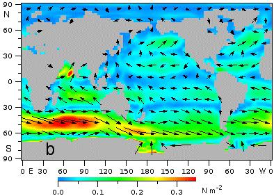
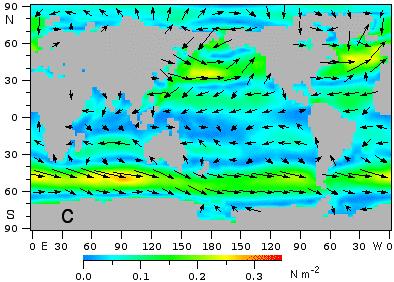
5 Introduction: What drives the ocean currents? 5 Fig Surface winds over the World Ocean. (a, page 4) Annual mean, (b, page 4) July mean, (c) January mean. Data from the NOAA Live Climate Data Server using the Comprehensive Atmosphere/Ocean Data Set (COADS) climatology. COADS is based on ship observations; regions without data are gray. Colour indicates wind speed. Seafarers know them well and refer to them as the Roaring Forties, thus expressing their experience that between 40 and 50 latitude the winds are usually strong, highly variable and very gusty. Figure 1.2 gives the winds at sea level in the real world. The features seen in Figure 1.1 come out clearly, but the presence of continental land masses modifies the atmospheric circulation further. Because air heats up faster over the continents than over the oceans during summer, and cools faster during winter, large land masses are characterized by low air pressure in summer - relative to air pressure over the ocean at the same latitude - and high air pressure in winter. This results in a deviation of average wind direction from mainly easterly or mainly westerly over some parts of the oceans. Some ocean regions experience strong seasonal variations in wind direction, including complete reversal. Such wind systems are known as monsoons. In passing, it should be noted that the convention for indicating the direction of ocean currents differs from the convention used for wind directions. A "westerly" wind is a wind which blows from the west and goes to the east; a "westward" current is a current which
6
 climatology. COADS is based on ship observations.")
7 Introduction: What drives the ocean currents? 7 Fig Air pressure (hpa) at sea level. (a, page 6) July mean, (b) January mean. Broken lines show isobars at 5 hpa separation. Data from the NOAA Live Climate Data Server using the Comprehensive Atmosphere/Ocean Data Set (COADS) climatology. COADS is based on ship observations. the northern Indian Ocean) a discussion of the oceanic circulation starts from a well-defined annual mean, meteorology rarely looks at the annual mean atmospheric circulation. This has to do with the low thermal capacity of air, which results in much larger seasonal changes in the atmosphere than in the ocean (see Chapter 18) and makes the annual mean a rather irrelevant quantity. Figure 1.3 therefore shows only the January and July situation. Nevertheless, it gives some useful and instructive information; a comparison with the corresponding wind fields of Figure 1.2 in later chapters will document that the same rules which will be derived for the ocean in chapters 3-5 operate in the atmosphere. The modifications of the basic air pressure pattern of Figure 1.1 by the distribution of land and water are the outstanding features in the seasonal pressure maps. The zonal arrangement of high and low air pressure is seen most clearly in the southern hemisphere. Alternation between low pressure over continents and high pressure over the oceans during summer is particularly evident in the subtropics, but it is easy to see that the basic pattern is preserved in the zonal average. In the northern hemisphere the zonal distribution is disturbed by the Asian land mass which produces a summer low in northern Pakistan and an
8 intense winter
9 Introduction: What drives the ocean currents? 9
10

11 Introduction: What drives the ocean currents? 11 above sea level, and Cd is the dimensionless "drag coefficient". (Here and in the following, we use bold characters to denote vectors and normal italics for scalars and constants.) Appropriate values for Cd are still the subject of active research, and the uncertainty about its value adds to the lack of precise knowledge about the wind stress distribution over the ocean. Cd varies from about to depending on the air-sea temperature difference, the water roughness, and on the wind speed itself. A median value is about Figure 1.4 shows a recent representation of the oceanic wind stress field calculated from eqn (1.1) on the basis of merchant ship data and often used in numerical ocean models. Note that the mean wind stress is not necessarily parallel to the mean wind but is determined by the direction of the strongest winds. Around Antarctica, for example, mean winds are westerlies (Figure 1.2) but the mean wind stresses follow the northwesterly direction of the strong winds in the storm systems. In the northern hemisphere the gusty Westerlies produce larger stresses than the strong but less gusty Trades. We conclude this chapter by briefly reviewing the atmospheric conditions imposed on the fluxes of heat and mass. Figure 1.5 gives annual mean solar radiation as received at the sea surface; 93% of it is absorbed by the ocean. Solar radiation is naturally largest in the tropics and in cloud-free regions. Again, the observed field shows significant departures from a simple zonal pattern as a result of the distribution of land and water, mainly through Fig Annual mean heat flux into the ocean (W m -2 ). Minimum values in the Kuroshio exceed 150 W m -2, in the Gulf Stream 200 W m -2.Data from Oberhuber (1988). Regions with insufficient data to construct an annual mean are gray. The contouring interval is 50 W m -2.
12
13 Introduction: What drives the ocean currents? 13 Generally speaking, the ocean gains heat in the tropics (between 20 S and 20 N) and loses heat in the temperate and polar regions. Departures from this simple zonal distribution are, however, so large that this generalization becomes rather meaningless. Cool water must flow into the regions of net ocean heat gain, and the warmed water must flow away from these regions; this advection does not occur uniformly at all longitudes but in currents of limited longitudinal extent, e.g. along the coasts of Peru and Somalia. Similarly the large heat losses in the Kuroshio and Gulf Stream regions along the coasts of Japan and the eastern USA are caused by rapid poleward advection of warm water. These processes will be addressed in detail in the discussion of individual oceans. The mass or freshwater flux, i.e. the transport of water between the ocean and the atmosphere, is controlled by the difference between rainfall and runoff from land on one hand and evaporation from the ocean surface on the other hand. (Evaporation from land need not be considered here, since it does not represent a gain or loss to the ocean.) Figure 1.7 shows a recent estimate of the annual mean distribution of precipitation minus evaporation (P-E). Maximum P-E values are found in the ITCZ (known to mariners as the Doldrums) where moist air rises to great height, releasing its water vapour; values of 500 cm/year and more are observed east of Indonesia. Mean sea surface salinity, shown in Figure 2.5b, clearly reflects the mass flux field, most notably in the generally zonal arrangement of the isohalines: lowest salinities tend to occur in regions of maximum P-E, although the relationship is not that simple in detail. Again, modifications are generated by the distribution of land and water and by air and ocean currents. An obvious example is the effect of the limited communication between Indian Ocean and Red Sea waters which produces extreme surface salinities in the latter. Further discussion of these and other aspects is postponed to the appropriate chapters.
General Circulation. Nili Harnik DEES, Lamont-Doherty Earth Observatory
 General Circulation Nili Harnik DEES, Lamont-Doherty Earth Observatory nili@ldeo.columbia.edu Latitudinal Radiation Imbalance The annual mean, averaged around latitude circles, of the balance between the
The Planetary Circulation System
 12 The Planetary Circulation System Learning Goals After studying this chapter, students should be able to: 1. describe and account for the global patterns of pressure, wind patterns and ocean currents
Lecture 5: Atmospheric General Circulation and Climate
 Lecture 5: Atmospheric General Circulation and Climate Geostrophic balance Zonal-mean circulation Transients and eddies Meridional energy transport Moist static energy Angular momentum balance Atmosphere
Global Wind Patterns
 Name: Earth Science: Date: Period: Global Wind Patterns 1. Which factor causes global wind patterns? a. changes in the distance between Earth and the Moon b. unequal heating of Earth s surface by the Sun
Wind: Global Systems Chapter 10
 Wind: Global Systems Chapter 10 General Circulation of the Atmosphere General circulation of the atmosphere describes average wind patterns and is useful for understanding climate Over the earth, incoming
ATMO 436a. The General Circulation. Redacted version from my NATS lectures because Wallace and Hobbs virtually ignores it
 ATMO 436a The General Circulation Redacted version from my NATS lectures because Wallace and Hobbs virtually ignores it Scales of Atmospheric Motion vs. Lifespan The general circulation Atmospheric oscillations
Winds and Global Circulation
 Winds and Global Circulation Atmospheric Pressure Winds Global Wind and Pressure Patterns Oceans and Ocean Currents El Nino How is Energy Transported to its escape zones? Both atmospheric and ocean transport
CHAPTER 2 - ATMOSPHERIC CIRCULATION & AIR/SEA INTERACTION
 Chapter 2 - pg. 1 CHAPTER 2 - ATMOSPHERIC CIRCULATION & AIR/SEA INTERACTION The atmosphere is driven by the variations of solar heating with latitude. The heat is transferred to the air by direct absorption
Upper Ocean Circulation
 Upper Ocean Circulation C. Chen General Physical Oceanography MAR 555 School for Marine Sciences and Technology Umass-Dartmouth 1 MAR555 Lecture 4: The Upper Oceanic Circulation The Oceanic Circulation
CHAPTER 9 ATMOSPHERE S PLANETARY CIRCULATION MULTIPLE CHOICE QUESTIONS
 CHAPTER 9 ATMOSPHERE S PLANETARY CIRCULATION MULTIPLE CHOICE QUESTIONS 1. Viewed from above in the Northern Hemisphere, surface winds about a subtropical high blow a. clockwise and inward. b. counterclockwise.
Quiz 2 Review Questions
 Quiz 2 Review Questions Chapter 7 Lectures: Winds and Global Winds and Global Winds cont 1) What is the thermal circulation (thermal wind) and how does it form? When we have this type of circulation, how
Lecture 8. Monsoons and the seasonal variation of tropical circulation and rainfall
 Lecture 8 Monsoons and the seasonal variation of tropical circulation and rainfall According to the second hypothesis, the monsoon is a manifestation of the seasonal variation of the tropical circulation
F = ma. ATS 150 Global Climate Change Winds and Weather. Scott Denning CSU CMMAP 1. Please read Chapter 6 from Archer Textbook
 Winds and Weather Please read Chapter 6 from Archer Textbook Circulation of the atmosphere and oceans are driven by energy imbalances Energy Imbalances What Makes the Wind Blow? Three real forces (gravity,
GEO1010 tirsdag
 GEO1010 tirsdag 31.08.2010 Jørn Kristiansen; jornk@met.no I dag: Først litt repetisjon Stråling (kap. 4) Atmosfærens sirkulasjon (kap. 6) Latitudinal Geographic Zones Figure 1.12 jkl TØRR ATMOSFÆRE Temperature
Atmospheric Circulation
 Atmospheric Circulation Introductory Oceanography Instructor: Ray Rector Atmospheric Circulation Key Topics Composition and Structure Solar Heating and Convection The Coriolis Effect Global Wind Patterns
Weather Systems. Section
 Section 1 12.2 Objectives Compare and contrast the three major wind systems. Identify four types of fronts. Distinguish between highand low-pressure systems. Review Vocabulary convection: the transfer
Unit Three Worksheet Meteorology/Oceanography 2 WS GE U3 2
 Unit Three Worksheet Meteorology/Oceanography 2 WS GE U3 2 Name Period Section 17.3 1. 2. 3. 4. 5. 6. 7. 8. Of the following, which is NOT a factor that controls temperature? (C) latitude (D) longitude
Wind, Water, Weather and Seasons Test Review
 Name: Wind, Water, Weather and Seasons Test Review Period: Please complete the following review to prepare for your exam over wind and ocean currents, weather, and the Earth- Moon- Sun systems. Your test
1 What Is Climate? TAKE A LOOK 2. Explain Why do areas near the equator tend to have high temperatures?
 CHAPTER 17 1 What Is Climate? SECTION Climate BEFORE YOU READ After you read this section, you should be able to answer these questions: What is climate? What factors affect climate? How do climates differ
Science 1206 Chapter 1 - Inquiring about Weather
 Science 1206 Chapter 1 - Inquiring about Weather 1.1 - The Atmosphere: Energy Transfer and Properties (pp. 10-25) Weather and the Atmosphere weather the physical conditions of the atmosphere at a specific
The feature of atmospheric circulation in the extremely warm winter 2006/2007
 The feature of atmospheric circulation in the extremely warm winter 2006/2007 Hiroshi Hasegawa 1, Yayoi Harada 1, Hiroshi Nakamigawa 1, Atsushi Goto 1 1 Climate Prediction Division, Japan Meteorological
1 What Is Climate? TAKE A LOOK 2. Explain Why do areas near the equator tend to have high temperatures?
 CHAPTER 17 1 What Is Climate? SECTION Climate BEFORE YOU READ After you read this section, you should be able to answer these questions: What is climate? What factors affect climate? How do climates differ
Climate and the Atmosphere
 Climate and Biomes Climate Objectives: Understand how weather is affected by: 1. Variations in the amount of incoming solar radiation 2. The earth s annual path around the sun 3. The earth s daily rotation
General Atmospheric Circulation
 General Atmospheric Circulation Take away Concepts and Ideas Global circulation: The mean meridional (N-S) circulation Trade winds and westerlies The Jet Stream Earth s climate zones Monsoonal climate
Ocean Mixing and Climate Change
 Ocean Mixing and Climate Change Factors inducing seawater mixing Different densities Wind stirring Internal waves breaking Tidal Bottom topography Biogenic Mixing (??) In general, any motion favoring turbulent
Introduction to Atmospheric Circulation
 Introduction to Atmospheric Circulation Start rotating table Cloud Fraction Dice Results from http://eos.atmos.washington.edu/erbe/ from http://eos.atmos.washington.edu/erbe/ from http://eos.atmos.washington.edu/erbe/
2. Meridional atmospheric structure; heat and water transport. Recall that the most primitive equilibrium climate model can be written
 2. Meridional atmospheric structure; heat and water transport The equator-to-pole temperature difference DT was stronger during the last glacial maximum, with polar temperatures down by at least twice
Atmospheric Circulation and the Global Climate System A map-based exploration
 Name: Answer key Atmospheric Circulation and the Global Climate System A map-based exploration Introduction: Exploration of Earth s radiation budget (Units 4 and 5) reveals regions of positive and negative
CHAPTER 6 Air-Sea Interaction Pearson Education, Inc.
 CHAPTER 6 Air-Sea Interaction Chapter Overview The atmosphere and the ocean are one independent system. Earth has seasons because of the tilt on its axis. There are three major wind belts in each hemisphere.
Climate Dynamics (PCC 587): Hydrologic Cycle and Global Warming
: Hydrologic Cycle and Global Warming") Climate Dynamics (PCC 587): Hydrologic Cycle and Global Warming D A R G A N M. W. F R I E R S O N U N I V E R S I T Y O F W A S H I N G T O N, D E P A R T M E N T O F A T M O S P H E R I C S C I E N C
Climate Dynamics (PCC 587): Hydrologic Cycle and Global Warming D A R G A N M. W. F R I E R S O N U N I V E R S I T Y O F W A S H I N G T O N, D E P A R T M E N T O F A T M O S P H E R I C S C I E N C
Chapter 8 Circulation of the Atmosphere
 Chapter 8 Circulation of the Atmosphere The Atmosphere Moves in Response to Uneven Solar Heating and Earth s s Rotation Solar Radiation - initial source of energy to the Earth. It can be absorbed, reflected
Chapter 6. Antarctic oceanography
 Chapter 6 Antarctic oceanography The region of the world ocean bordering on Antarctica is unique in many respects. First of all, it is the only region where the flow of water can continue all around the
Climate versus Weather
 Climate versus Weather What is climate? Climate is the average weather usually taken over a 30-year time period for a particular region and time period. Climate is not the same as weather, but rather,
Contents. Section 1: Climate Factors. Section 2: Climate Types. Section 3: Climate Effects
 Contents Section 1: Climate Factors 1. Weather or Climate?.... 2 2. Elements of Climate.... 4 3. Factors Affecting Climate.... 10 4. Comparing Climates.... 15 5. Quiz 1.... 20 Section 2: Climate Types
Transient/Eddy Flux. Transient and Eddy. Flux Components. Lecture 7: Disturbance (Outline) Why transients/eddies matter to zonal and time means?
 Why transients/eddies matter to zonal and time means?") Lecture 7: Disturbance (Outline) Transients and Eddies Climate Roles Mid-Latitude Cyclones Tropical Hurricanes Mid-Ocean Eddies (From Weather & Climate) Flux Components (1) (2) (3) Three components contribute
Lecture 7: Disturbance (Outline) Transients and Eddies Climate Roles Mid-Latitude Cyclones Tropical Hurricanes Mid-Ocean Eddies (From Weather & Climate) Flux Components (1) (2) (3) Three components contribute
Marine Ecoregions. Marine Ecoregions. Slide 1. Robert G. Bailey. USDA Forest Service Rocky Mountain Research Station
 Slide 1 Marine Ecoregions Robert G. Bailey Marine Ecoregions Robert G. Bailey USDA Forest Service Rocky Mountain Research Station rgbailey@fs.fed.us Draft of 7/20/2006 8:44 PM Abstract: Oceans occupy some
Climate vs. Weather. Weather: Short term state of the atmosphere. Climate: The average weather conditions in an area over a long period of time
 Weather and Climate Climate vs. Weather Weather: Short term state of the atmosphere. Temperature, humidity, cloud cover, precipitation, winds, visibility, air pressure, air pollution, etc Climate: The
Energy Systems, Structures and Processes Essential Standard: Analyze patterns of global climate change over time Learning Objective: Differentiate
 Energy Systems, Structures and Processes Essential Standard: Analyze patterns of global climate change over time Learning Objective: Differentiate between weather and climate Global Climate Focus Question
Week: Dates: 3/2 3/20 Unit: Climate
 clementaged.weebly.com Name: EVEN Period: Week: 28 30 Dates: 3/2 3/20 Unit: Climate Monday Tuesday Wednesday Thursday Friday 2 O 3 E *Vocabulary *Water in the Atmosphere and Clouds Notes *Cloud Drawings
Lecture 1. Amplitude of the seasonal cycle in temperature
 Lecture 6 Lecture 1 Ocean circulation Forcing and large-scale features Amplitude of the seasonal cycle in temperature 1 Atmosphere and ocean heat transport Trenberth and Caron (2001) False-colour satellite
Meteorology 311. General Circulation/Fronts Fall 2017
 Meteorology 311 General Circulation/Fronts Fall 2017 Precipitation Types Rain Snow growth of ice crystals through deposition, accretion, and aggregation. Freezing Rain Rain freezes when it hits the surface.
Name Period 4 th Six Weeks Notes 2013 Weather
 Name Period 4 th Six Weeks Notes 2013 Weather Radiation Convection Currents Winds Jet Streams Energy from the Sun reaches Earth as electromagnetic waves This energy fuels all life on Earth including the
Fluid Circulation Review. Vocabulary. - Dark colored surfaces absorb more energy.
 Fluid Circulation Review Vocabulary Absorption - taking in energy as in radiation. For example, the ground will absorb the sun s radiation faster than the ocean water. Air pressure Albedo - Dark colored
Global Atmospheric Moisture Budget
 Global Atmospheric Moisture Budget Sinan Sahin (1), Juerg Luterbacher (2), Elena Xoplaki (2), and Murat Türkeş (3) (1) Department of Civil Engineering, Faculty of Çorlu Engineering, Namik Kemal University/TURKEY
ATMOSPHERIC CIRCULATION AND WIND
 ATMOSPHERIC CIRCULATION AND WIND The source of water for precipitation is the moisture laden air masses that circulate through the atmosphere. Atmospheric circulation is affected by the location on the
Ocean s Influence on Weather and Climate
 Earth is often called the Blue Planet because so much of its surface (about 71%) is covered by water. Of all the water on Earth, about 96.5%, is held in the world s oceans. As you can imagine, these oceans
Lecture 9: General Circulation
 Lecture 9: General Circulation JS JP Hadley Cell Ferrel Cell (driven by eddies) Polar Cell L H L H Three-Cell Circulation in the Atmosphere Gyres in the Oceans Single-Cell Model: Explains Why There are
Lecture 9: General Circulation Explains Why There are Tropical Easterlies
 Lecture 9: General Circulation Single-Cell Model: Explains Why There are Tropical Easterlies JS JP Hadley Cell Ferrel Cell (driven by eddies) Polar Cell Without Earth Rotation With Earth Rotation L H L
What is the Madden-Julian Oscillation (MJO)?
?") What is the Madden-Julian Oscillation (MJO)? Planetary scale, 30 90 day oscillation in zonal wind, precipitation, surface pressure, humidity, etc., that propagates slowly eastward Wavelength = 12,000 20,000
What is the Madden-Julian Oscillation (MJO)? Planetary scale, 30 90 day oscillation in zonal wind, precipitation, surface pressure, humidity, etc., that propagates slowly eastward Wavelength = 12,000 20,000
MAR 110 LECTURE #10 The Oceanic Conveyor Belt Oceanic Thermohaline Circulation
 1 MAR 110 LECTURE #10 The Oceanic Conveyor Belt Oceanic Thermohaline Circulation Ocean Climate Temperature Zones The pattern of approximately parallel oceanic surface isotherms (lines of constant temperature)
C
 C 0.8 0.4 0.2 0.0-0.2-0.6 Fig. 1. SST-wind relation in the North Pacific and Atlantic Oceans. Left panel: COADS SST (color shade), surface wind vectors, and SLP regressed upon the Pacific Decadal Oscillation
AIR MASSES SOURCE REGION CHARACTERISTICS Continental Arctic (ca) Greenland, Antarctica, Highest latitudes of Asia and North America
 Greenland, Antarctica, Highest latitudes of Asia and North America") GEOGRAPHY CLIMATOLOGY AIRMASS, FRONT AND TEMPERATE CYCLONE AIRMASS A large body of air having little horizontal variation in temperature and moisture is called an airmass. Airmass acquires its properties
GEOGRAPHY CLIMATOLOGY AIRMASS, FRONT AND TEMPERATE CYCLONE AIRMASS A large body of air having little horizontal variation in temperature and moisture is called an airmass. Airmass acquires its properties
b. The boundary between two different air masses is called a.
 NAME Earth Science Weather WebQuest Part 1. Air Masses 1. Find out what an air mass is. http://okfirst.mesonet.org/train/meteorology/airmasses.html a. What is an air mass? An air mass is b. The boundary
Vertical Structure of Atmosphere
 ATMOS 3110 Introduction to Atmospheric Sciences Distribution of atmospheric mass and gaseous constituents Because of the earth s gravitational field, the atmosphere exerts a downward forces on the earth
Chapter 10: Mid-latitude Cyclones Mid-Latitude Cyclones
 Chapter 10: Mid-latitude Cyclones Mid-Latitude Cyclones Mid-latitude cyclones form along a boundary separating polar air from warmer air to the south. Life Cycle of Cyclone Cyclone Structures Steering
Chapter 10: Mid-latitude Cyclones
 Chapter 10: Mid-latitude Cyclones Life Cycle of Cyclone Cyclone Structures Steering of Cyclone Mid-Latitude Cyclones Mid-latitude cyclones form along a boundary separating polar air from warmer air to
1. Introduction 2. Ocean circulation a) Temperature, salinity, density b) Thermohaline circulation c) Wind-driven surface currents d) Circulation and
 Temperature, salinity, density b) Thermohaline circulation c) Wind-driven surface currents d) Circulation and") 1. Introduction 2. Ocean circulation a) Temperature, salinity, density b) Thermohaline circulation c) Wind-driven surface currents d) Circulation and climate change e) Oceanic water residence times 3.
1. Introduction 2. Ocean circulation a) Temperature, salinity, density b) Thermohaline circulation c) Wind-driven surface currents d) Circulation and climate change e) Oceanic water residence times 3.
Your web browser (Safari 7) is out of date. For more security, comfort and the best experience on this site: Update your browser Ignore
 is out of date. For more security, comfort and the best experience on this site: Update your browser Ignore") Your web browser (Safari 7) is out of date. For more security, comfort and the best experience on this site: Update your browser Ignore JET STREAM For the complete encyclopedic entry with media resources,
Your web browser (Safari 7) is out of date. For more security, comfort and the best experience on this site: Update your browser Ignore JET STREAM For the complete encyclopedic entry with media resources,
Weather Notes. Chapter 16, 17, & 18
 Weather Notes Chapter 16, 17, & 18 Weather Weather is the condition of the Earth s atmosphere at a particular place and time Weather It is the movement of energy through the atmosphere Energy comes from
General Circulation of the Atmosphere. René Garreaud
 General Circulation of the Atmosphere René Garreaud www.dgf.uchile.cl/rene General circulation of the Atmosphere Low latitude areas receive more solar energy than high latitudes (because of earth sphericity).
Transient and Eddy. Transient/Eddy Flux. Flux Components. Lecture 3: Weather/Disturbance. Transient: deviations from time mean Time Mean
 Lecture 3: Weather/Disturbance Transients and Eddies Climate Roles Mid-Latitude Cyclones Tropical Hurricanes Mid-Ocean Eddies Transient and Eddy Transient: deviations from time mean Time Mean Eddy: deviations
Weather & Ocean Currents
 Weather & Ocean Currents Earth is heated unevenly Causes: Earth is round Earth is tilted on an axis Earth s orbit is eliptical Effects: Convection = vertical circular currents caused by temperature differences
Atmospheric circulation
 Atmospheric circulation Trade winds http://science.nasa.gov/science-news/science-at-nasa/2002/10apr_hawaii/ Atmosphere (noun) the envelope of gases (air) surrounding the earth or another planet Dry air:
Ocean Currents and Climate
 Ocean Currents and Climate Ocean water contains streamlike movements of water called ocean currents. Currents are influenced by a number of factors, including weather, the Earth's rotation, and the position
- tornadoes. Further Reading: Chapter 08 of the text book. Outline. - cyclones and anti-cyclones. -tropical storms. -Storm surge
 (1 of 16) Further Reading: Chapter 08 of the text book Outline - cyclones and anti-cyclones - tornadoes -tropical storms -Storm surge (2 of 16) Introduction Previously, We talked about fronts and their
Hadley Circulation in Action. MET 200 Lecture 12! Global Winds: The General Circulation of the Atmosphere. Scales of Motion
 Hadley Circulation in Action MET 200 Lecture 12! Global Winds: The General Circulation of the Atmosphere 1 2 Previous Lecture Local Winds cales of Motion Eddies ea Breeze Mountain-Valley Circulations Chinook
Ocean surface circulation
 Ocean surface circulation Recall from Last Time The three drivers of atmospheric circulation we discussed: Differential heating Pressure gradients Earth s rotation (Coriolis) Last two show up as direct
Adopt a Drifter Lesson Plan by Mary Cook, Middle School Science Teacher, Ahlf Jr. High School, Searcy, Arkansas
 Adopt a Drifter Lesson Plan by Mary Cook, Middle School Science Teacher, Ahlf Jr. High School, Searcy, Arkansas Do Ocean Surface Currents Influence Climate? Objectives Students will construct climographs
Mid-latitude Cyclones & Air Masses
 Lab 9 Mid-latitude Cyclones & Air Masses This lab will introduce students to the patterns of surface winds around the center of a midlatitude cyclone of low pressure. The types of weather associated with
Global Weather Trade Winds etc.notebook February 17, 2017
 Global Weather 1 north pole northern hemisphere equator southern hemisphere south pole 2 We have seasons because of the Earth's tilt The seasons are opposite in the northern and southern hemispheres winter
Warm Up Vocabulary Check
 Warm Up Vocabulary Check Surface current Coriolis Effect global winds upwelling Gulf Stream deep current climate El Nino convection current continental deflection 1.The apparent curving of the path of
Winds and Currents in the Oceans
 Winds and Currents in the Oceans Atmospheric Processes Density of air is controlled by temperature, pressure, and moisture content. 1. Warm air is less dense than cold air and moist air is less dense than
Hurricanes and Tropical Weather Systems:
 Hurricanes and Tropical Weather Systems: An influence on weather in parts of the USA Meteorology 411 Iowa State University Week 2 Bill Gallus Classification/Terminology Tropical Disturbance enhanced convection
Prentice Hall EARTH SCIENCE
 Prentice Hall EARTH SCIENCE Tarbuck Lutgens Chapter 21 Climate 21.1 Factors That Affect Climate Factors That Affect Climate Latitude As latitude increases, the intensity of solar energy decreases. The
LAB G - ATMOSPHERE AND CLIMATE LAB I TEMPERATURE AND PRESSURE PRESSURE PORTION
 LAB G - ATMOSPHERE AND CLIMATE LAB I TEMPERATURE AND PRESSURE PRESSURE PORTION Introduction This lab will provide the student with the opportunity to become familiar with the concepts introduced in Chapter
Global Atmospheric Circulation
 Global Atmospheric Circulation Polar Climatology & Climate Variability Lecture 11 Nov. 22, 2010 Global Atmospheric Circulation Global Atmospheric Circulation Global Atmospheric Circulation The Polar Vortex
DEAPS Activity 3 Weather systems and the general circulation of the atmosphere
 DEAPS Activity 3 Weather systems and the general circulation of the atmosphere Lodovica Illari 1 Introduction What is responsible for stormy weather? What causes relatively warm temperatures one day and
Sensitivity of zonal-mean circulation to air-sea roughness in climate models
 Sensitivity of zonal-mean circulation to air-sea roughness in climate models Inna Polichtchouk & Ted Shepherd Royal Meteorological Society National Meeting 16.11.2016 MOTIVATION Question: How sensitive
Torben Königk Rossby Centre/ SMHI
 Fundamentals of Climate Modelling Torben Königk Rossby Centre/ SMHI Outline Introduction Why do we need models? Basic processes Radiation Atmospheric/Oceanic circulation Model basics Resolution Parameterizations
Directed Reading. Section: Ocean Currents. a(n). FACTORS THAT AFFECT SURFACE CURRENTS
. FACTORS THAT AFFECT SURFACE CURRENTS") Skills Worksheet Directed Reading Section: Ocean Currents 1 A horizontal movement of water in a well-defined pattern is called a(n) 2 What are two ways that oceanographers identify ocean currents? 3 What
Skills Worksheet Directed Reading Section: Ocean Currents 1 A horizontal movement of water in a well-defined pattern is called a(n) 2 What are two ways that oceanographers identify ocean currents? 3 What
Surface Circulation. Key Ideas
 Surface Circulation The westerlies and the trade winds are two of the winds that drive the ocean s surface currents. 1 Key Ideas Ocean water circulates in currents. Surface currents are caused mainly by
Investigation A: OCEAN IN THE GLOBAL WATER CYCLE
 Investigation A: OCEAN IN THE GLOBAL WATER CYCLE (NOTE: Completion of this activity requires Internet access.) Driving Question: What role does the ocean play in the global water cycle within the Earth
Tropical Meteorology. Roger K. Smith INDO IR
 Tropical Meteorology Roger K. Smith INDO IR 01010510 1 GMS IR 01022621 GOES IR 00112909 2 Introduction to the tropics The zonal mean circulation (Hadley circulation) The data network in the tropics (field
Meteorology B Wright State Invite Team Name Team # Student Members: &
 1 Meteorology B Team Name Team # Student Members: & Raw Score: / 126 Rank: Part I. Multiple Choice. Answer the following questions by selecting the best answer. 2 points each. 1. All of the following are
Project Retrograde imagine Earth rotated in the opposite direction
 Project Retrograde imagine Earth rotated in the opposite direction The rotation of Earth shapes our climate system in various ways: It controls the major wind directions, lets the weather systems swirl,
Regional Oceanography: an Introduction
 64 Regional Oceanography: an Introduction 2500 m depth, or 10-30% of the speeds observed at the 500 m level. It is therefore easy to see why the Circumpolar Current has the largest mass transport of all
Earth s Climate Patterns
 Earth s Climate Patterns Reading: Chapter 17, GSF 10/2/09 Also Jackson (linked on course web site) 1 What aspects of climate affect plant distributions? Climate: long-term distribution of weather in an
The North Atlantic Oscillation: Climatic Significance and Environmental Impact
 1 The North Atlantic Oscillation: Climatic Significance and Environmental Impact James W. Hurrell National Center for Atmospheric Research Climate and Global Dynamics Division, Climate Analysis Section
Introduction to tropical meteorology and deep convection
 Introduction to tropical meteorology and deep convection TMD Lecture 1 Roger K. Smith University of Munich A satpix tour of the tropics The zonal mean circulation (Hadley circulation), Inter- Tropical
warmest (coldest) temperatures at summer heat dispersed upward by vertical motion Prof. Jin-Yi Yu ESS200A heated by solar radiation at the base
 temperatures at summer heat dispersed upward by vertical motion Prof. Jin-Yi Yu ESS200A heated by solar radiation at the base") Pole Eq Lecture 3: ATMOSPHERE (Outline) JS JP Hadley Cell Ferrel Cell Polar Cell (driven by eddies) L H L H Basic Structures and Dynamics General Circulation in the Troposphere General Circulation in the
Pole Eq Lecture 3: ATMOSPHERE (Outline) JS JP Hadley Cell Ferrel Cell Polar Cell (driven by eddies) L H L H Basic Structures and Dynamics General Circulation in the Troposphere General Circulation in the
(after Stephens et al. 2012)
") Energy Balance Incoming solar radiation 34 Reflected solar radiation Outgoing longwave radiation 1 24 TOA 75 Atmospheric absorption Atmospheric reflection 77 Atmospheric window 4 165 35 Clear Sky Cloud
Energy Balance Incoming solar radiation 34 Reflected solar radiation Outgoing longwave radiation 1 24 TOA 75 Atmospheric absorption Atmospheric reflection 77 Atmospheric window 4 165 35 Clear Sky Cloud
Go With the Flow From High to Low Investigating Isobars
 Go With the Flow From High to Low Investigating Isobars Science 10 Mrs. Purba Air Masses The air over a warm surface can be heated, causing it to rise above more dense air. The result is the formation
Tropical Meridional Circulations: The Hadley Cell
 Tropical Meridional Circulations: The Hadley Cell Introduction Throughout much of the previous sections, we have alluded to but not fully described the mean meridional overturning circulation of the tropics
Ocean in Motion 7: El Nino and Hurricanes!
 Ocean in Motion 7: El Nino and Hurricanes! A. Overview 1. Ocean in Motion -- El Nino and hurricanes We will look at the ocean-atmosphere interactions that cause El Nino and hurricanes. Using vocabulary
Chapter 2 Weather Patterns Guided Notes Objective(s): 7.E.1.4 Predict weather conditions and patterns based on information obtained from:
: 7.E.1.4 Predict weather conditions and patterns based on information obtained from:") Chapter 2 Weather Patterns Guided Notes Objective(s): 7.E.1.4 Predict weather conditions and patterns based on information obtained from: Weather data collected from direct observations and measurement
Chapter 2 Weather Patterns Guided Notes Objective(s): 7.E.1.4 Predict weather conditions and patterns based on information obtained from: Weather data collected from direct observations and measurement
16 Global Climate. Learning Goals. Summary. After studying this chapter, students should be able to:
 16 Global Climate Learning Goals After studying this chapter, students should be able to: 1. associate the world s six major vegetation biomes to climate (pp. 406 408); 2. describe methods for classifying
Space Atmospheric Gases. the two most common gases; found throughout all the layers a form of oxygen found in the stratosphere
 Earth s atmospheric layers Earth s atmosphere is the layer of gases that surrounds the planet and makes conditions on Earth suitable for living things. Layers Earth s atmosphere is divided into several
Oceanography Quiz 2. Multiple Choice Identify the choice that best completes the statement or answers the question.
 Oceanography Quiz 2 Multiple Choice Identify the choice that best completes the statement or answers the question. 1. The highest and lowest tides are known as the spring tides. When do these occur? a.
Name the surface winds that blow between 0 and 30. GEO 101, February 25, 2014 Monsoon Global circulation aloft El Niño Atmospheric water
 GEO 101, February 25, 2014 Monsoon Global circulation aloft El Niño Atmospheric water Name the surface winds that blow between 0 and 30 What is the atmospheric pressure at 0? What is the atmospheric pressure
What a Hurricane Needs to Develop
 Weather Weather is the current atmospheric conditions, such as air temperature, wind speed, wind direction, cloud cover, precipitation, relative humidity, air pressure, etc. 8.10B: global patterns of atmospheric