An Isentropic Perspective on Two Cases of Elevated Convection. Patrick S. Market Dept. of Soil, Env. & Atmospheric Sciences University of Missouri
|
|
|
- Britney Melton
- 5 years ago
- Views:
Transcription
1 An Isentropic Perspective on Two Cases of Elevated Convection Patrick S. Market Dept. of Soil, Env. & Atmospheric Sciences University of Missouri
2 Elevated Convection INTRODUCTION
3 Colman (1990a,b) Initiated the modern era of elevated convection studies Showed the preferred region of elevated convection in US northeast of a surface cyclone north of its attendant warm front
4 Colman (1990a,b) More importantly, suggested that these elevated layers were often devoid of convective available potential energy (CAPE) This latter finding suggests an environment ill-suited to deep, moist thunderstorm towers.
 Heavy snowfall (Moore et al. 1998) Severe weather Grant (1995) Horgan et al.")
5 Later work Yet, ensuing studies have shown elevated convection can result in Heavy rainfall (Rochette and Moore 1996) Heavy snowfall (Moore et al. 1998) Severe weather Grant (1995) Horgan et al. (2006, 2007) Colby and Walker (2007)
6 Even later work Further study by Rochette et al. (1999) heightened the contrast with the findings of Colman (1990a,b) showing that there were environments of elevated convection that had significant CAPE
7 Even later work Wetzel and Martin (2001) showed decisively that the presence of instability could enhance snowfall totals Moore et al. (2003) described the processes leading to a less stable environment as ones leading to greater precipitation totals
8 Even later work Knox and Schultz (2006) factors not related to buoyancy might be related to elevated convection Specifically, atmosphere might also be susceptible to inertial (horizontal) instability, especially on the equatorward side of jet streak structures
9 Even later work Corfidi et al. (2006) examined the nature of altocumulus castellanus determined that the division between elevated and surface-based [convective] activity is rarely distinct.
10 Elevated Convection METHODOLOGY
11 Trajectory Analyses For this talk, NAM-WRF solutions used Good subjective verification for both cases GFS and RUC trajectories are being created for comparison Ongoing
12 Trajectory Analyses Trajectory specs 180 minute (3-hr time step) Isentropic Backwards from location of interest
13 Elevated Convection CASE STUDY 28 NOVEMBER 2005 W MINNESOTA

14 12Z 2005 Nov 28

15 12Z 2005 Nov 28

16 12Z 2005 Nov mb

17 12Z 2005 Nov mb

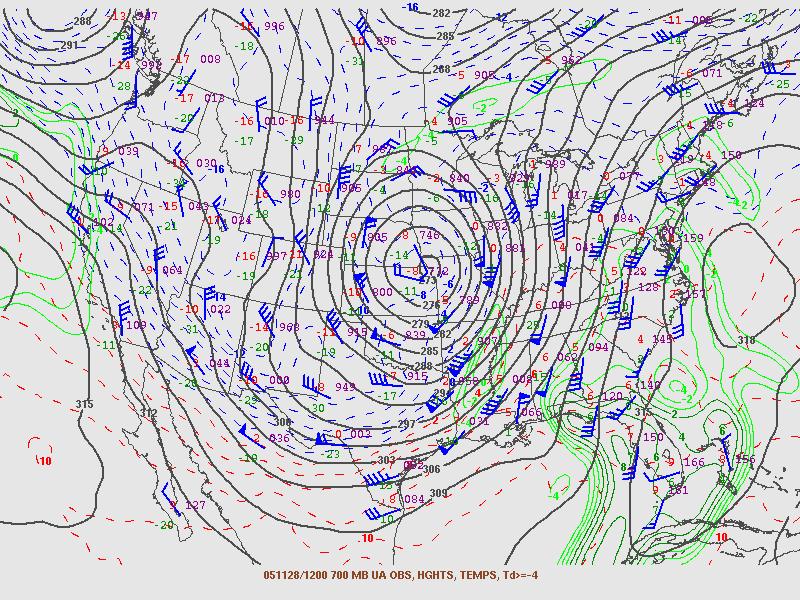
18 12Z 2005 Nov mb

19 12Z 2005 Nov mb

20 12Z 2005 Nov mb

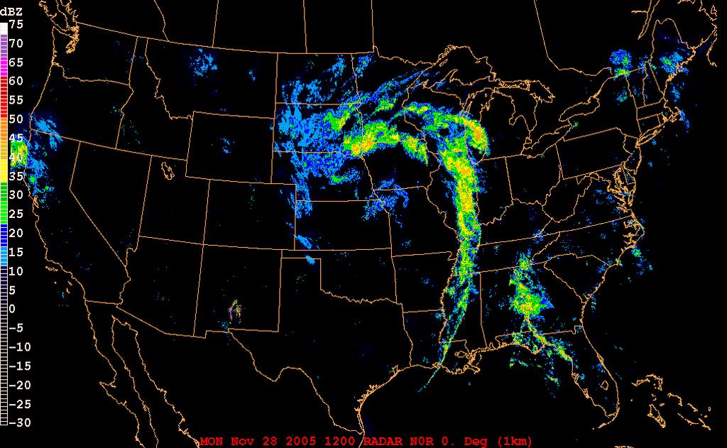
21 12Z 2005 Nov 28 RADAR
, 27-30 Nov")
22 Storm total snow (in.), Nov 2005

23 2005 Nov Z Redevelopment of lightning in NE Emergence of trowal feature And a unique double trowal signature Evolution of meso- circulations Significant banded precipitation underway
24 2005 Nov 28 - Fergus Falls, MN


25 2005 Nov 28 21Z NAM 21-hr fcst FFM sndg

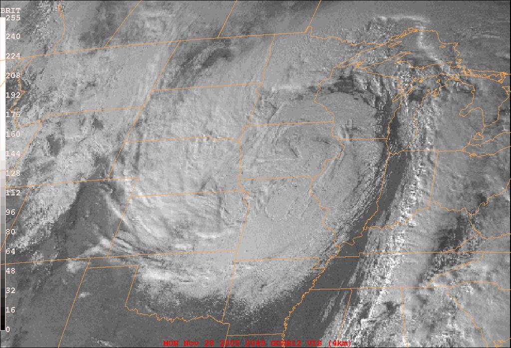
26 2005 Nov 28 21Z VIS Sat

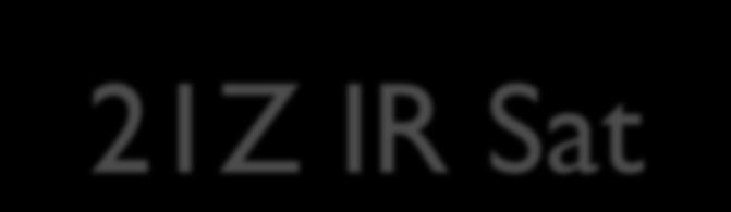
27 2005 Nov 28 21Z IR Sat

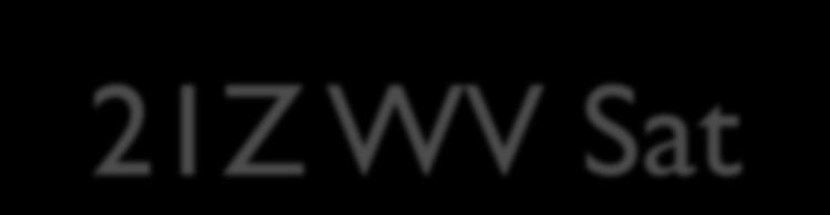
28 2005 Nov 28 21Z WV Sat

29 2005 Nov 28 21Z Sounder CTP

30 2005 Nov 28 21Z RADAR


31 2005 Nov 28 IR Loop 13Z-23Z

32 2005 Nov 28 RADAR Loop 18Z-23Z


33 2005 Nov 28 - Fergus Falls, MN

34 2005 Nov K Trajectory Swarm

35 2005 Nov hr 298K trajectory with pressure at F012

36 294K white 296K red 298K green 300K blue 302K gold 2005 Nov 28 Vertical airstream structure
37 Elevated Convection CASE STUDY 21 FEBRUARY SW MISSOURI
38 METARS 21 February 2008 KJLN Z AUTO 05010KT 10SM OVC027 M02/M12 A3009 KJLN Z AUTO 07009KT 10SM OVC025 M02/M11 A3006 KJLN Z AUTO 07010KT 10SM OVC025 M01/M11 A3004 KJLN Z AUTO 08014G20KT 10SM OVC023 M01/M09 A3001 KJLN Z 08010G16KT 5SM TS -FZRA BR FEW015 BKN020 OVC055 M02/M04 A2999 KJLN Z 08011KT 4SM TS FZRA BR OVC013 M02/M04 A2997 RMK AO2 PRESFR P0003 KJLN Z 07010G14KT 1 3/4SM FZRA BR OVC007 M01/M03 A2998 KJLN Z 09009KT 3SM TS -FZRA BR FEW006 BKN027 OVC035 M01/M02 A2999 RMK AO2 TSB02 P0014 KJLN Z 10008KT 2 1/2SM TS FZRA BR SCT006 BKN020 OVC070 M01/M02 A2998 KJLN Z 10009KT 3SM TS -FZRA BR BKN006 OVC017 00/M02 A2994

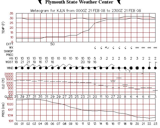
39 METARS 21 February 2008

40 Surface 12Z 21 February 2008

41 Surface 12Z 21 February 2008

42 850 mb 12Z 21 February 2008

43 500 mb 12Z 21 February 2008

44 250 mb 12Z 21 February 2008

45 WV 12Z 21 February 2008

46 IR 12Z 21 February 2008

47 IR 21 February 2008

48 WV 21 February 2008


49 SGF 88D 21 February 2008

50 NLDN 21 February 2008

51 SGF sounding (OBS) 12Z - 21 February 2008

52 SGF sounding (RUC) 12Z - 21 February 2008


53 NAM Forecast - JLN Time Height Section - 21 February 2008


54 JLN

55 NAM-WRF 294K Trajectory swarm F000-F012 from 00Z 21 February 2008 run

56 NAM-WRF Forecast 294K p and Ψ, F012 from 00Z 21 February 2008

57 NAM-WRF Forecast 294K ω, F012 from 00Z 21 February 2008


58 NAM-WRF Trajectory 294K F000-F012 from 00Z 21 February 2008 run
 292K green (9 hr) 294K green 296K blue 298K")
59 NAM-WRF Vertical airstream structure F000-F012 from 00Z 21 February 2008 run 290K red (9 hr) 292K green (9 hr) 294K green 296K blue 298K gold

60 Summary Subtle differences can influence trajectory Horizontal location Vertical location Time period of trajectory Parcel crashes not always a bad thing Help to define origins of air feeding convection


61 Thank you! Comments? Questions? Crisiticism?
IMPROVING PREDICTION OF HEAVY RAINFALL WITH ELEVATED CONVECTION
 IMPROVING PREDICTION OF HEAVY RAINFALL WITH ELEVATED CONVECTION Patrick Market, University of Missouri Laurel McCoy, University of Missouri and NOAA/NWS, Portland, OR Chad Gravelle, CIMSS/SSEC University
P0.98 Composite Analysis of Heavy-Rain-Producing Elevated Thunderstorms in the MO-KS-OK region of the United States
 P0.98 Composite Analysis of Heavy-Rain-Producing Elevated Thunderstorms in the MO-KS-OK region of the United States Laurel P. McCoy and Patrick S. Market Department of Soil, Environmental, and Atmospheric
AN INDEX FOR ANTICIPATING EXCESSIVE PRECIPITATION WITH ELEVATED THUNDERSTORMS
 AN INDEX FOR ANTICIPATING EXCESSIVE PRECIPITATION WITH ELEVATED THUNDERSTORMS Alzina Foscato and Patrick Market Dept. of Soil, Environmental & Atmospheric Sciences University of Missouri Presented to the
P5.11 TACKLING THE CHALLENGE OF NOWCASTING ELEVATED CONVECTION
 P5.11 TACKLING THE CHALLENGE OF NOWCASTING ELEVATED CONVECTION Huaqing Cai*, Rita Roberts, Dan Megenhardt, Eric Nelson and Matthias Steiner National Center for Atmospheric Research, Boulder, CO, 80307,
Auto-Nowcast System Tom Saxen (July) Huaqing Cai (Aug) National Center for Atmospheric Research
 Huaqing Cai (Aug) National Center for Atmospheric Research") Auto-Nowcast System Tom Saxen (July) Huaqing Cai (Aug) National Center for Atmospheric Research Summer 2006 ATEC Forecaster Conference Photo courtesy of Greg Thompson Overview: Introductory comments on
Auto-Nowcast System Tom Saxen (July) Huaqing Cai (Aug) National Center for Atmospheric Research Summer 2006 ATEC Forecaster Conference Photo courtesy of Greg Thompson Overview: Introductory comments on
HIGH-RESOLUTION RAWINSONDE OBSERVATIONS OF THE COLD SECTOR PRECIPITATION REGIONS IN TRANSIENT MID-LATITUDE EXTRATROPICAL CYCLONES
 HIGH-RESOLUTION RAWINSONDE OBSERVATIONS OF THE COLD SECTOR PRECIPITATION REGIONS IN TRANSIENT MID-LATITUDE EXTRATROPICAL CYCLONES Patrick S. Market and Katie Crandall Department of Soil, Environmental
THE MAP ROOM. BAND ON THE RUN Chasing the Physical Processes Associated with Heavy Snowfall
 THE MAP ROOM BAND ON THE RUN Chasing the Physical Processes Associated with Heavy Snowfall BY CHARLES E. GRAVES, JAMES T. MOORE, MARC J. SINGER, AND SAM NG AFFILIATIONS: GRAVES, MOORE, AND NG Department
WxChallenge Model Output Page Tutorial
 WxChallenge Model Output Page Tutorial Brian Tang University at Albany - SUNY 9/25/12 http://www.atmos.albany.edu/facstaff/tang/forecast/ Clicking on square brings up graphic for the specified variable
ERTH 465 Fall Laboratory Exercise 5. Surface Weather Observations (METARS) and Frontal Analysis (300 pts)
 and Frontal Analysis (300 pts)") ERTH 465 Fall 2017 Laboratory Exercise 5 Surface Weather Observations (METARS) and Frontal Analysis (300 pts) Insert in ringed-three hole binder. Point deductions for sloppy or late work. Due date: Tuesday
ERTH 465 Fall 2017 Laboratory Exercise 5 Surface Weather Observations (METARS) and Frontal Analysis (300 pts) Insert in ringed-three hole binder. Point deductions for sloppy or late work. Due date: Tuesday
Summary of November Central U.S. Winter Storm By Christopher Hedge
 Summary of November 12-13 2010 Central U.S. Winter Storm By Christopher Hedge Event Overview The first significant snowfall of the 2010-2011 season affected portions of the plains and upper Mississippi
The abrupt end of the Persistent Subtropical Ridge of the autumn of 2016
 The abrupt end of the Persistent Subtropical Ridge of the autumn of 2016 1. Introduction by Richard H. Grumm National Weather Service State College, PA 16803 Contributions by Elyse Hagner National Weather
A Review of Thundersnow Events Across the United States
 A Review of Thundersnow Events Across the United States JoBeth Minniear and Elizabeth Suess 4/18/2010 Table of Contents 1. Introduction.............................1 2. Formation Types.............................1
Aviation Hazards: Thunderstorms and Deep Convection
 Aviation Hazards: Thunderstorms and Deep Convection TREND Diagnosis of thunderstorm hazards using imagery Contents Satellite imagery Visible, infrared, water vapour Basic cloud identification Identifying
Ensemble Trajectories and Moisture Quantification for the Hurricane Joaquin (2015) Event
 Event") Ensemble Trajectories and Moisture Quantification for the Hurricane Joaquin (2015) Event Chasity Henson and Patrick Market Atmospheric Sciences, School of Natural Resources University of Missouri 19 September
Ensemble Trajectories and Moisture Quantification for the Hurricane Joaquin (2015) Event Chasity Henson and Patrick Market Atmospheric Sciences, School of Natural Resources University of Missouri 19 September
The enduring fog and low cloud episode of 5-10 December 2015: Big Bubble Fog Trouble
 1. Overview The enduring fog and low cloud episode of 5-10 December 2015: Big Bubble Fog Trouble By Richard H. Grumm National Weather Service State College, PA An enduring low cloud and fog episode affected
Lec 10: Interpreting Weather Maps
 Lec 10: Interpreting Weather Maps Case Study: October 2011 Nor easter FIU MET 3502 Synoptic Hurricane Forecasts Genesis: on large scale weather maps or satellite images, look for tropical waves (Africa
A Comparison of Mid-Level Frontogenesis to Radar- Indicated Heavy Snowbands
 A Comparison of Mid-Level Frontogenesis to Radar- Indicated Heavy Snowbands Christopher D. Karstens Iowa State University Mentor: Dr. William A. Gallus, Jr. Iowa State University Overview Background Motivation
ERTH 465 Fall Laboratory Exercise 5. Surface Weather Observations (METARS) and Frontal Analysis (300 pts)
 and Frontal Analysis (300 pts)") ERTH 465 Fall 2017 Laboratory Exercise 5 Surface Weather Observations (METARS) and Frontal Analysis (300 pts) Insert in ringed-three hole binder. Point deductions for sloppy or late work. Due date: Tuesday
ERTH 465 Fall 2017 Laboratory Exercise 5 Surface Weather Observations (METARS) and Frontal Analysis (300 pts) Insert in ringed-three hole binder. Point deductions for sloppy or late work. Due date: Tuesday
July 13, 2017 Session #1 In Lieu of the Surface Observation Including EWINS Authority, RTMA, Web Cams, and Remote Observation Systems
 July 13, 2017 Session #1 In Lieu of the Surface Observation Including EWINS Authority, RTMA, Web Cams, and Remote Observation Systems Part 121 Operator Perspective: Equivalent Level of Safety Using Remote
TAIWIN: Operational Concept Review
 TAIWIN: Operational Concept Review S.D. Green November 19, 2015 Overview Changes to FAR Parts 25 and 33 including FAR 25.1420 and Appendix O, will allow limited icing certification for transport category
MSG FOR NOWCASTING - EXPERIENCES OVER SOUTHERN AFRICA
 MSG FOR NOWCASTING - EXPERIENCES OVER SOUTHERN AFRICA Estelle de Coning and Marianne König South African Weather Service, Private Bag X097, Pretoria 0001, South Africa EUMETSAT, Am Kavalleriesand 31, D-64295
Climatology of dry air intrusions and their relation to strong surface winds in extratropical cyclones
 Climatology of dry air intrusions and their relation to strong surface winds in extratropical cyclones...and intro to synoptic and meso-scale cyclone dynamics Shira Raveh-Rubin and Heini Wernli Institute
April 13, 2006: Analysis of the Severe Thunderstorms that produced Hail in Southern Wisconsin
 April 13, 2006: Analysis of the Severe Thunderstorms that produced Hail in Southern Wisconsin Danielle Triolo UW Madison Undergraduate 453 Case Study May 5, 2009 ABSTRACT On April 13, 2006 the states of
Department of Geosciences San Francisco State University Spring Metr 201 Monteverdi Quiz #5 Key (100 points)
") Department of Geosciences Name San Francisco State University Spring 2012 Metr 201 Monteverdi Quiz #5 Key (100 points) 1. Fill in the Blank or short definition. (3 points each for a total of 15 points)
Department of Geosciences Name San Francisco State University Spring 2012 Metr 201 Monteverdi Quiz #5 Key (100 points) 1. Fill in the Blank or short definition. (3 points each for a total of 15 points)
Northwest Flow Snow Events
 Northwest Flow Snow Events Winter Weather Prep Seminar December 2001 Modified December 2005 Prepared for a forecaster training seminar at WFO GSP Laurence G. Lee National Weather Service Greenville-Spartanburg
University of Maryland. Tuesday, February 7, 12
 AARON SCHULMAN NEIL SPRING University of Maryland Measuring weather-related failures Identify residential IPs that will be subject to weather Ping before, during, and after a weather event Analyze the
4.6 A CASE EXAMPLE OF THE ROLE OF WARM-SECTOR CONVECTION IN THE DEVELOPMENT OF MESOSCALE BANDED SNOWFALL: 2003 NOVEMBER 22-24
 4.6 A CASE EXAMPLE OF THE ROLE OF WARM-SECTOR CONVECTION IN THE DEVELOPMENT OF MESOSCALE BANDED SNOWFALL: 2003 NOVEMBER 22-24 Martin A. Baxter Central Michigan University Mt. Pleasant, MI Charles E. Graves
Chapter 14 Thunderstorm Fundamentals
 Chapter overview: Thunderstorm appearance Thunderstorm cells and evolution Thunderstorm types and organization o Single cell thunderstorms o Multicell thunderstorms o Orographic thunderstorms o Severe
Implementation and Evaluation of WSR-88D Reflectivity Data Assimilation for WRF-ARW via GSI and Cloud Analysis. Ming Hu University of Oklahoma
 Implementation and Evaluation of WSR-88D Reflectivity Data Assimilation for WRF-ARW via GSI and Cloud Analysis Ming Hu University of Oklahoma 1. Previous work and Goal of visiting Previous work: Radar
THE SYNOPTIC ENVIRONMENT OF THE 11 APRIL 2001 CENTRAL PLAINS TORNADO OUTBREAK VIEWED IN THREE DIMENSIONS
 P1.1 THE SYNOPTIC ENVIRONMENT OF THE 11 APRIL 2001 CENTRAL PLAINS TORNADO OUTBREAK VIEWED IN THREE DIMENSIONS Daniel D. Nietfeld * NOAA/NWS/WFO Omaha/Valley, NE 1. INTRODUCTION A powerful low pressure
Oakfield, WI Tornado of July 18 th, 1996: "Everything in its Right Place"
 Oakfield, WI Tornado of July 18 th, 1996: "Everything in its Right Place" Arian Sarsalari Department of Atmospheric and Oceanic Sciences, University of Wisconsin Madison ABSTRACT This paper will serve
Forcing, instability and equivalent potential vorticity in a Midwest USA convective snowstorm
 Meteorol. Appl. 10, 273 280 (2003) DOI:10.1017/S1350482703003074 Forcing, instability and equivalent potential vorticity in a Midwest USA convective snowstorm Department of Atmospheric Sciences, University
Sources of Hourly Surface Data and Weather Maps for the U.S.
 Sources of Hourly Surface Data and Weather Maps for the U.S. Weather Underground Weather Underground http://www.wunderground.com/history/ maintains a deep archive of hourly reports for around the world.
Talking points for Water Vapor Imagery Analysis for Severe Thunderstorm Forecasting.
 Talking points for Water Vapor Imagery Analysis for Severe Thunderstorm Forecasting. 1. Title. 2. Learning objectives. These are the topics we ll consider during this training session, the goal of the
contact with ground for 1 hour plus, starting 1500 MDT moved N., covered about 37 km width varied m
 Goal for today: Finish Ch. 11 Lightning, Thunder & Tornadoes 16 Nov., 2011 Edmonton tornado 31 July 1987 contact with ground for 1 hour plus, starting 1500 MDT moved N., covered about 37 km width varied
Multiscale Analyses of Inland Tropical Cyclone Midlatitude Jet Interactions: Camille (1969) and Danny (1997)
 and Danny (1997)") Multiscale Analyses of Inland Tropical Cyclone Midlatitude Jet Interactions: Camille (1969) and Danny (1997) Matthew Potter, Lance Bosart, and Daniel Keyser Department of Atmospheric and Environmental
Multiscale Analyses of Inland Tropical Cyclone Midlatitude Jet Interactions: Camille (1969) and Danny (1997) Matthew Potter, Lance Bosart, and Daniel Keyser Department of Atmospheric and Environmental
Northeastern United States Snowstorm of 9 February 2017
 Northeastern United States Snowstorm of 9 February 2017 By Richard H. Grumm and Charles Ross National Weather Service State College, PA 1. Overview A strong shortwave produced a stripe of precipitation
ASSIMILATION OF METAR CLOUD AND VISIBILITY OBSERVATIONS IN THE RUC
 9.13 ASSIMILATION OF METAR CLOUD AND VISIBILITY OBSERVATIONS IN THE RUC Stanley G. Benjamin, Stephen S. Weygandt, John M. Brown, Tracy Lorraine Smith 1, Tanya Smirnova 2, William R. Moninger, Barry Schwartz,
Preliminary results. Leonardo Calvetti, Rafael Toshio, Flávio Deppe and Cesar Beneti. Technological Institute SIMEPAR, Curitiba, Paraná, Brazil
 HIGH RESOLUTION WRF SIMULATIONS FOR WIND GUST EVENTS Preliminary results Leonardo Calvetti, Rafael Toshio, Flávio Deppe and Cesar Beneti Technological Institute SIMEPAR, Curitiba, Paraná, Brazil 3 rd WMO/WWRP
THE INFLUENCE OF THE GREAT LAKES ON NORTHWEST SNOWFALL IN THE SOUTHERN APPALACHIANS
 P2.18 THE INFLUENCE OF THE GREAT LAKES ON NORTHWEST SNOWFALL IN THE SOUTHERN APPALACHIANS Robbie Munroe* and Doug K. Miller University of North Carolina at Asheville, Asheville, North Carolina B. Holloway
Tornadogenesis in Supercells: The Three Main Ingredients. Ted Funk
 Tornadogenesis in Supercells: The Three Main Ingredients Ted Funk NWS Louisville, KY Spring 2002 Environmental Parameters Supercells occur within environments exhibiting several wellknown characteristics
Numerical Simulation of a Severe Thunderstorm over Delhi Using WRF Model
 International Journal of Scientific and Research Publications, Volume 5, Issue 6, June 2015 1 Numerical Simulation of a Severe Thunderstorm over Delhi Using WRF Model Jaya Singh 1, Ajay Gairola 1, Someshwar
Sources of Hourly Surface Data and Weather Maps for the U.S.
 Sources of Hourly Surface Data and Weather Maps for the U.S. Weather Underground Weather Underground http://www.wunderground.com/history/ maintains a deep archive of hourly reports for around the world.
IOP-2 Summary of Operations 03 June UTC 04 June UTC Authors: Market, Kastman
 IOP-2 Summary of Operations 03 June 2014 2200 UTC 04 June 2014 1200 UTC Authors: Market, Kastman IOP-2 focused on the slow-moving warm front that extended east from a cyclone that was situated over eastern
Mid-Atlantic Ice Storm 4 March 2015
 1. Overview Mid-Atlantic Ice Storm 4 March 2015 By Richard H. Grumm National Weather Service State College, PA A large 500 hpa ridge over the southern United States (Fig. 1a-e)) built into the Mid-Atlantic
All About Lake-Effect Snow
 All About Lake-Effect Snow Tom Niziol Winter Weather Expert The Weather Channel CoCoRaHs Seminar November 12 th, 2015 Outline Definition of Lake/Ocean Effect Snow (LOES) Favored Locations in North America/World
Predecessor Rain Events: A Literature Review. By: Tony Viramontez
 Predecessor Rain Events: A Literature Review By: Tony Viramontez Introduction Predecessor Rain Event (PRE): meso- and subsynopticscale regions of high-impact heavy rainfall that occur well in advance of
10-11 April 2003 Cut-off Southern Appalachian Snowstorm by Richard Grumm
 10-11 April 2003 Cut-off Southern Appalachian Snowstorm by Richard Grumm 1. Introduction This paper will show the anomalies associated A deep upper level cut-off low moved up the east coast on 10 and 11
Investigation of the Arizona Severe Weather Event of August 8 th, 1997
 Investigation of the Arizona Severe Weather Event of August 8 th, 1997 Tim Hollfelder May 10 th, 2006 Abstract Synoptic scale forcings were very weak for these thunderstorms on August 7-8, 1997 over the
Introduction to NCEP's time lagged North American Rapid Refresh Ensemble Forecast System (NARRE-TL)
") Introduction to NCEP's time lagged North American Rapid Refresh Ensemble Forecast System (NARRE-TL) Binbin Zhou 1,2, Jun Du 2, Geoff Manikin 2 & Geoff DiMego 2 1. I.M. System Group 2. EMC/NCEP/NWS/NOAA
Introduction to NCEP's time lagged North American Rapid Refresh Ensemble Forecast System (NARRE-TL) Binbin Zhou 1,2, Jun Du 2, Geoff Manikin 2 & Geoff DiMego 2 1. I.M. System Group 2. EMC/NCEP/NWS/NOAA
Denver International Airport MDSS Demonstration Verification Report for the Season
 Denver International Airport MDSS Demonstration Verification Report for the 2015-2016 Season Prepared by the University Corporation for Atmospheric Research Research Applications Division (RAL) Seth Linden
Denver International Airport MDSS Demonstration Verification Report for the Season
 Denver International Airport MDSS Demonstration Verification Report for the 2014-2015 Season Prepared by the University Corporation for Atmospheric Research Research Applications Division (RAL) Seth Linden
Masahiro Kazumori, Takashi Kadowaki Numerical Prediction Division Japan Meteorological Agency
 Development of an all-sky assimilation of microwave imager and sounder radiances for the Japan Meteorological Agency global numerical weather prediction system Masahiro Kazumori, Takashi Kadowaki Numerical
This course is based on notes from a variety of textbooks, National Weather Service Manuals, and online modules (e.g.,
 ESCI 6216 Synoptic Meteorology MWF, 9:10-10:05 a.m., JN 222 Course Syllabus Fall 2014 Instructor: Office: Phone: E-Mail: Website: Dr. Dorian J. Burnette 230, Johnson Hall 901-678-4452 djbrntte@memphis.edu
Severe storms over the Mediterranean Sea: A satellite and model analysis
 National Research Council of Italy Severe storms over the Mediterranean Sea: A satellite and model analysis V. Levizzani, S. Laviola, A. Malvaldi, M. M. Miglietta, and E. Cattani 6 th International Precipitation
AMDAR Forecast Applications. Richard Mamrosh NWS Green Bay, Wisconsin, USA
 AMDAR Forecast Applications Richard Mamrosh NWS Green Bay, Wisconsin, USA AMDAR has many applications Aviation Low level wind shear Ceilings and visibilities Icing and turbulence Winter Storms Precipitation
A Comparison of Mid-Level Frontogenesis to Radar- Indicated Heavy Snowbands
 A Comparison of Mid-Level Frontogenesis to Radar- Indicated Heavy Snowbands CHRISTOPHER D. KARSTENS Iowa State University, Ames, Iowa Mentor: Dr. William A. Gallus Jr. Iowa State University, Ames, Iowa
COMPOSITE ANALYSIS OF THUNDERSNOW EVENTS IN THE CENTRAL UNITED STATES
 COMPOSITE ANALYSIS OF THUNDERSNOW EVENTS IN THE CENTRAL UNITED STATES A Thesis Presented to the Faculty of the Graduate School University of Missouri-Columbia In Partial Fulfillment for the Degree Master
For the operational forecaster one important precondition for the diagnosis and prediction of
 Initiation of Deep Moist Convection at WV-Boundaries Vienna, Austria For the operational forecaster one important precondition for the diagnosis and prediction of convective activity is the availability
Examination #3 Wednesday, 28 November 2001
 Name & Signature Dr. Droegemeier Student ID Meteorology 1004 Introduction to Meteorology Fall, 2001 Examination #3 Wednesday, 28 November 2001 BEFORE YOU BEGIN!! Please be sure to read each question CAREFULLY
Part. I Introduction. Part II Scale Characteristics and Climatology of MCSs
 Talking points for MCS teletraining session Part. I Introduction Slide 1 Slides 2-3 Title Objectives Part II Scale Characteristics and Climatology of MCSs Slides 4-5 Climatology of mesoscale convective
National Weather Service-Pennsylvania State University Weather Events
 National Weather Service-Pennsylvania State University Weather Events Historic Ohio Valley January Severe weather and Tornado Event by Richard H. Grumm National Weather Service State College PA 16803 and
Mid-Latitude Cyclones and Fronts. Lecture 12 AOS 101
 Mid-Latitude Cyclones and Fronts Lecture 12 AOS 101 Homework 4 COLDEST TEMPS GEOSTROPHIC BALANCE Homework 4 FASTEST WINDS L Consider an air parcel rising through the atmosphere The parcel expands as it
Joshua M. Boustead *1 NOAA/NWS WFO Omaha/Valley, NE. Philip N. Schumacher NOAA/NWS WFO Sioux Falls, SD
 11B.2 Influence of Diabatic Potential Vorticity Anomalies upon Warm Conveyor Belt Flow. Part II: 3-5 January 2005 Joshua M. Boustead *1 NOAA/NWS WFO Omaha/Valley, NE Philip N. Schumacher NOAA/NWS WFO Sioux
DEPARTMENT OF EARTH & CLIMATE SCIENCES NAME SAN FRANCISCO STATE UNIVERSITY Fall ERTH FINAL EXAMINATION KEY 200 pts
 DEPARTMENT OF EARTH & CLIMATE SCIENCES NAME SAN FRANCISCO STATE UNIVERSITY Fall 2016 Part 1. Weather Map Interpretation ERTH 365.02 FINAL EXAMINATION KEY 200 pts Questions 1 through 9 refer to Figure 1,
ATS 351, Spring 2010 Lab #9 Weather Radar - 55 points
 ATS 351, Spring 2010 Lab #9 Weather Radar - 55 points 1. (5 points) If a radar has a maximum unambiguous range of 300km, what is its PRF? (The speed of light, c, is equal to 3x10 8 m/s) 2. (5 points) Explain
Di Wu, Xiquan Dong, Baike Xi, Zhe Feng, Aaron Kennedy, and Gretchen Mullendore. University of North Dakota
 Di Wu, Xiquan Dong, Baike Xi, Zhe Feng, Aaron Kennedy, and Gretchen Mullendore University of North Dakota Objectives 3 case studies to evaluate WRF and NAM performance in Oklahoma (OK) during summer 2007,
The WRF Microphysics and a Snow Event in Chicago
 2.49 The WRF Microphysics and a Snow Event in Chicago William Wilson* NOAA/NWS/WFO Chicago 1. Introduction Mesoscale meteorological models are increasingly being used in NWS forecast offices. One important
Cloud-to-Ground Lightning Production in Strongly Forced, Low- Instability Convective Lines
 Cloud-to-Ground Lightning Production in Strongly Forced, Low- Instability Convective Lines Matthew S. Van Den Broeke National Weather Center Research Experiences for Undergraduates, and Valparaiso University
National Transportation Safety Board Office of Aviation Safety Washington, D.C December 10, 2012 WEATHER STUDY DCA13RA025
 A. ACCIDENT National Transportation Safety Board Office of Aviation Safety Washington, D.C. 20594-2000 December 10, 2012 WEATHER STUDY DCA13RA025 Location: Monterrey, Mexico Date: December 9, 2012 Time:
Heavy Rainfall Event of June 2013
 Heavy Rainfall Event of 10-11 June 2013 By Richard H. Grumm National Weather Service State College, PA 1. Overview A 500 hpa short-wave moved over the eastern United States (Fig. 1) brought a surge of
Meteorology METARs. References: FTGU pages AWWS:
 Meteorology 5.09 METARs References: FTGU pages 160-163 AWWS: www.flightplanning.navcanada.ca 5.09 METARs MTPs: Weather Observing Stations METARs Weather Observing Stations Weather observation are taken
Meteorology METARs Weather Observing Stations. MTPs: 5.09 METARs References: FTGU pages AWWS:
 Meteorology 5.09 References: FTGU pages 160-163 AWWS: www.flightplanning.navcanada.ca MTPs: Weather Observing Stations 5.09 Weather Observing Stations Weather observation are taken every hour at selected
Aircraft-based Observations: Impact on weather forecast model performance
 Aircraft-based Observations: Impact on weather forecast model performance Stephen S. Weygandt Eric James, Stan Benjamin, Bill Moninger, Brian Jamison, Geoff Manikin* NOAA Earth System Research Laboratory
Atmospheric Moisture, Precipitation, and Weather Systems
 Atmospheric Moisture, Precipitation, and Weather Systems 6 Chapter Overview The atmosphere is a complex system, sometimes described as chaotic in nature. In this chapter we examine one of the principal
The Impacts of GPSRO Data Assimilation and Four Ices Microphysics Scheme on Simulation of heavy rainfall Events over Taiwan during June 2012
 The Impacts of GPSRO Data Assimilation and Four Ices Microphysics Scheme on Simulation of heavy rainfall Events over Taiwan during 10-12 June 2012 Pay-Liam LIN, Y.-J. Chen, B.-Y. Lu, C.-K. WANG, C.-S.
Aviation Weather Reports
 Aviation Weather Reports Aviation Weather Reports METAR: hourly weather report (issued on the hour every hour) SPECI: special weather observations issued at times other than on the hour, as a result of
Aviation Hazards: Thunderstorms and Deep Convection
 Aviation Hazards: Thunderstorms and Deep Convection TREND Empirical thunderstorm forecasting techniques Contents Necessary conditions for convection: Instability Low-level moisture Trigger mechanism Forecasting
Monteverdi Metr 201 Quiz #4 100 pts.
 DEPARTMENT OF GEOSCIENCES Name San Francisco State University April 27, 2012 Monteverdi Metr 201 Quiz #4 100 pts. A. Definitions. (5 points each for a total of 25 points in this section). (a) Convective
The most abundant gas in the atmosphere by volume is. This gas comprises 78% of the Earth atmosphere by volume.
 The most abundant gas in the atmosphere by volume is. This gas comprises 78% of the Earth atmosphere by volume. A. Oxygen B. Water Vapor C. Carbon Dioxide D. Nitrogen An isobar is a line of constant. A.
Issue of SIGMET/AIRMET warning
 Issue of SIGMET/AIRMET warning 1 Presentation Objectives After this presentation session you will be able to: Warn for Hazardous weather phenomena using the correct ICAO coding with regards to SIGMET/AIRMET
and 24 mm, hPa lapse rates between 3 and 4 K km 1, lifted index values
 3.2 Composite analysis 3.2.1 Pure gradient composites The composite initial NE report in the pure gradient northwest composite (N = 32) occurs where the mean sea level pressure (MSLP) gradient is strongest
University of Maryland. Friday, February 10, 12
 AARON SCHULMAN NEIL SPRING University of Maryland Residential links may fail Links are not redundant Equipment updates are rare Equipment operates in an uncontrolled environment photo credit: Patrick Shoemaker,
DISCRIMINATION OF ELEVATED CONVECTION BASED ON LOW-LEVEL RADAR-DERIVED CONVERGENCE
 DISCRIMINATION OF ELEVATED CONVECTION BASED ON LOW-LEVEL RADAR-DERIVED CONVERGENCE A Thesis Presented to the Faculty of the Graduate School at the University of Missouri In Partial Fulfillment of the Requirements
CASE STUDIES OF MIDWESTERN THUNDERSNOW EVENTS. A Thesis Presented to the Faculty of the Graduate School University of Missouri-Columbia
 CASE STUDIES OF MIDWESTERN THUNDERSNOW EVENTS A Thesis Presented to the Faculty of the Graduate School University of Missouri-Columbia In Partial Fulfillment for the Degree Master of Science by CHRISTOPHER
Effective: SPECI ALERTING
 AUSTRALIA AERONAUTICAL INFORMATION SERVICE AIRSERVICES AUSTRALIA GPO BOX 367, CANBERRA ACT 2601 Phone: 02 6268 4874 Email: aim.editorial@airservicesaustralia.com Effective: AERONAUTICAL INFORMATION CIRCULAR
ATM OCN 452. The Frontal Cyclone. Fall 2013
 ATM OCN 452 The Frontal Cyclone Fall 2013 Instructor: Dr. Jonathan E. Martin 1425A Meteorology and Space Science jemarti1@wisc.edu 262-9845 Office Hours: Wed. 12:30 2:25 (or by appointment) T. A.: Andrew
KEY TO DECODING THE U.S. METAR OBSERVATION REPORT
 KEY TO DECODING THE U.S. METAR OBSERVATION REPORT Example METAR Report METAR KABC 121755Z AUTO 21016G24KT 180V240 1SM R11/P6000FT -RA BR BKN015 0VC025 06/04 A2990 RMK A02 PK WND 20032/25 WSHFT 1715 VIS
Isentropic Analysis. Much of this presentation is due to Jim Moore, SLU
 Isentropic Analysis Much of this presentation is due to Jim Moore, SLU Utility of Isentropic Analysis Diagnose and visualize vertical motion - through advection of pressure and system-relative flow Depict
Science Olympiad Meteorology Quiz #2 Page 1 of 8
 1) The prevailing general direction of the jet stream is from west to east in the northern hemisphere: 2) Advection is the vertical movement of an air mass from one location to another: 3) Thunderstorms
A COMPREHENSIVE 5-YEAR SEVERE STORM ENVIRONMENT CLIMATOLOGY FOR THE CONTINENTAL UNITED STATES 3. RESULTS
 16A.4 A COMPREHENSIVE 5-YEAR SEVERE STORM ENVIRONMENT CLIMATOLOGY FOR THE CONTINENTAL UNITED STATES Russell S. Schneider 1 and Andrew R. Dean 1,2 1 DOC/NOAA/NWS/NCEP Storm Prediction Center 2 OU-NOAA Cooperative
Final Examination, MEA 443 Fall 2008, Lackmann
 Place an X here to count it double! Name: Final Examination, MEA 443 Fall 2008, Lackmann If you wish to have the final exam count double and replace your midterm score, place an X in the box above. As
METEOROLOGY. 1 The average height of the tropopause at 50 N is about A 14 km B 16 km C 11 km D 8 km
 1 The average height of the tropopause at 50 N is about A 14 km B 16 km C 11 km D 8 km 2 In the lower part of the stratosphere the temperature A is almost constant B decreases with altitude C increases
The April 1982 "Big SurVtorm: An Example of Extreme Rainfall in California
 The April 1982 "Big SurVtorm: An Example of Extreme Rainfall in California Richard Grotjahn and Su-Tzai Soong Dept. of Land, Air, and Water Resources Univ. of California, Davis, 95616 modumon During the
P3.17 THE DEVELOPMENT OF MULTIPLE LOW-LEVEL MESOCYCLONES WITHIN A SUPERCELL. Joshua M. Boustead *1 NOAA/NWS Weather Forecast Office, Topeka, KS
 P3.17 THE DEVELOPMENT OF MULTIPLE LOW-LEVEL MESOCYCLONES WITHIN A SUPERCELL Joshua M. Boustead *1 NOAA/NWS Weather Forecast Office, Topeka, KS Philip N. Schumacher NOAA/NWS Weather Forecaster Office, Sioux
Kenneth L. Pryor* and Gary P. Ellrod Center for Satellite Applications and Research (NOAA/NESDIS) Camp Springs, MD
 Camp Springs, MD") P1.57 GOES WMSI PROGRESS AND DEVELOPMENTS Kenneth L. Pryor* and Gary P. Ellrod Center for Satellite Applications and Research (NOAA/NESDIS) Camp Springs, MD 1. INTRODUCTION A multi-parameter index has
P1.57 GOES WMSI PROGRESS AND DEVELOPMENTS Kenneth L. Pryor* and Gary P. Ellrod Center for Satellite Applications and Research (NOAA/NESDIS) Camp Springs, MD 1. INTRODUCTION A multi-parameter index has
Weather. Chapter Test A. Multiple Choice. Write the letter of the correct answer on the line at the left.
 Weather Chapter Test A Multiple Choice Write the letter of the correct answer on the line at the left. 1. The most dangerous aspect of a snowstorm is often the a. high winds. b. depth of snow. c. brightness.
MET 3502 Synoptic Meteorology. Lecture 8: September 16, AIRMASSES, FRONTS and FRONTAL ANALYSIS (2)
") MET 3502 Synoptic Meteorology Lecture 8: September 16, 2010 AIRMASSES, FRONTS and FRONTAL ANALYSIS (2) Identifying a cold front on a surface weather map: 1. Surface front is located at the leading edge
MET 3502 Synoptic Meteorology Lecture 8: September 16, 2010 AIRMASSES, FRONTS and FRONTAL ANALYSIS (2) Identifying a cold front on a surface weather map: 1. Surface front is located at the leading edge
DAVE LEVIN AARON SCHULMAN
 YOUNDO LEE DAVE LEVIN NEIL SPRING RAMAKRISHNA PADMANABHAN University of Maryland AARON SCHULMAN Stanford Weather causes residential link failures Lightning destroys equipment and causes interference Water
Lecture 14. Extratropical Cyclones extratropical cyclone
 Lecture 14. Extratropical Cyclones In mid-latitudes, much of our weather is associated with a particular kind of storm, the extratropical cyclone Cyclone: circulation around low pressure center Some midwesterners