The abrupt end of the Persistent Subtropical Ridge of the autumn of 2016
|
|
|
- Maude Blankenship
- 5 years ago
- Views:
Transcription
1 The abrupt end of the Persistent Subtropical Ridge of the autumn of Introduction by Richard H. Grumm National Weather Service State College, PA Contributions by Elyse Hagner National Weather Service Morristown,TN A persistent subtropical ridge dominated the pattern over southern United States and the Gulf of Mexico during the autumn of This feature led to 3 months of above normal 500 hpa heights over much of the eastern United States (Fig. 1a) and above normal 850 hpa temperatures over a similar region (Fig. 1b). In the mean, the surface pressure was close to normal with a weak ridge focused over the southeastern United States (Fig. 1c). This feature kept deep moisture and high precipitable water (PW) air out of the southern United States (Fig. 1d). There was some return flow moisture over the western plains and into central Canada where the PW values were above normal during the 3-month period. The impact of the ridge from 1 September 2016 through 28 November 2016 (Fig. 2a) was a dearth of precipitation in the southeastern United States. The data is shown minus the last 2 days of November 2016 to highlight the dry conditions in the southeastern United States prior to the abrupt change. The data for the full 3-month period (Fig. 2b) reveals a significant change which produced heavy rainfall over a significant portion of the dry region in the southeastern United States. This rainfall event at the end of the month had the unfortunate impact of producing strong winds which spread fires in Tennessee destroying significant portion of Gatlinburg, TN. The severe weather and heavy rains closer to frontal passage put an end to the fires and dramatically changed the rainfall over most of the region. The strong frontal system of November 2016 was notable for the strong winds ahead of the frontal system, the multi-day severe weather event it triggered, and the heavy rainfall which put a significant dent in the rainfall deficit over the region. This paper will document the odd convergence of conditions which produced the southeastern drought, the devastating fires, and the heavy rainfall. 2. Methods and data The climate forecast system re-analysis (CFSR) data was used to reconstruct the pattern and the standardized anomalies associated with the event. The CFSR was used to create composites for the season and for the months. The compositing required computing the mean and the mean of the departures in 6-hour increments covering the range. The primary ranges used included 0000 UTC 1 September through 1800 UTC 30 November, times for individual months, and ranges ending up to the time of the heavy rainfall and severe weather. Individual times were also produced during the key times of the rapidly spreading fires and the severe weather. 1
2 The Stage-IV rainfall data (Seo 1998) was used to estimate the rainfall over several 6, 12 and 24, monthly, and case related discrete times to show the impact of the pattern changing rainfall event. The rainfall pattern also revealed some interesting information about the southeastern drought and how both meteorologically and climatologically significant the precipitation event of November 2016 was for the southeastern United States. Forecasts from the NCEP GEFS and NCAR 3km are ensemble are used to illustrate how well the change in the pattern occurred. The strong winds ahead of the front had a devastating impact on fires in the southern Appalachian Mountains and the rainfall but a significant dent in the rainfall deficit. The GEFS and NCAR EFS both performed well for this significant high impact weather event. 3. Results a. The Large scale pattern The large scale pattern over North America during the autumn of 2016 (Fig. 1) showed the persistent ridge over southern North America and the Gulf of Mexico. This feature remained quite strong and persistent during the month of November 2016 (Fig. 3). The key features and anomalies persisted over the month despite the dramatic change in the pattern (Fig. 4) which brought lower heights and colder temperatures into the south-central United States. It also produced a plume of deep moisture across the southeastern United States. This system clearly was a game changing weather event over much of the eastern United States. b. Regional Pattern The regional pattern focus is on the frontal system and the strong winds ahead of the front. The 850 hpa winds in 6-hour increments from 1200 UTC 28 to 1800 UTC 29 November (Fig. 5) show the strong low-level jet ahead of the front. Winds in excess of 40 ms -1 were observed over Tennessee at 0000 UTC 29 November 2016 (Fig. 5c). The v-wind anomalies at the same time (Fig. 6) indicated 3 to 4σ above normal southerly winds in the region. The observations in Knoxville, TN (Appendix I) showed strong winds and frequent wind gusts of 30 to 43kts during the afternoon hours of 28 November Ahead and along the frontal boundary (Fig. 7) there was a surge of high PW air. The PW anomalies peaked at around +2 to +3σ above normal just ahead of the frontal system (Fig. 8). The 850 hpa temperature change was not remarkable ahead of the first front and was more like a dry surge than a strong cold front. Examining the 850 hpa temperatures in 12 hour increments reveals that a second stronger frontal boundary pushed through the region on 1 December 2016 (Fig. 9). It will be shown that this second system produced a widespread severe weather event and produced heavy rainfall over the region. c. Rainfall and severe weather The rainfall displayed in 12 hour increments from 1200 UTC 29 to 1200 UTC 01 December 2016 are shown in Figure 9. The period of heaviest rainfall was the period of 1200 UTC 30 November through 0000 UTC 1 December 2016 (Fig. 9e). These data show the rainfall entering the central Tennessee for the period ending at 0000 UTC 29 November
3 The total rainfall for this period (Fig. 10) showed areas of over 128 mm of rainfall in eastern Tennessee with a broad region of over 32 mm covering all but western Tennessee. The surge of the two fronts brought a heavy rainfall event to the region putting a significant dent in the rainfall deficit. This rainfall deficit at 3 observations locations was in excess of 10 inches (Table 1) leading up the event. In addition to the winds ahead of the front and the rainfall, the strong frontal system produced severe weather (Fig. 11). The 3-day event produced mainly severe convective winds on 28 November, a significant tornado event was observed on 29 November with at least 56 reported tornadoes including 3 deadly tornadoes in Alabama 1 and one deadly tornado in Tennessee. The third day of the event included a mix of severe thunderstorms and tornadoes from eastern Alabama into North Carolina (not shown) with 9 tornadoes and 44 severe wind reports. d. Forecasts The GEFS forecast the passage of a strong low-level southerly jet over Tennessee on between 1800 UTC 28 to 0600 UTC 29 November 2016 (Fig ). The 850 hpa winds and v-wind anomalies are shown for the periods of 0000 UTC and 0600 UTC 29 November when the peak winds were forecast to move across eastern Tennessee. Clearly, shorter range forecasts had stronger winds and larger v-wind anomalies, on the order of 4 to 5σ above normal. The 925 hpa winds peaked around 0000 UTC (Fig. 14) and farther to the west than the 850 hpa winds. The GEFS had clear signals for a strong low-level jet and the potential for strong and gusty winds with several days of lead time. The GEFS QPFs (Fig ) showed the potential for 25 to 50 mm rainfall event over the 48 hour period from 1200 UTC 29 November through 1200 UTC 01 December These numbers are low relative to the observed rainfall over this period. They do however reflect a significant rainfall event in what was a drought stricken area. Despite the low QPF this was still a significant QPF event with the potential to produce a fire squelching rainfall. The potential for strong winds at or near the surface was examined using the NCAR 3km ensemble forecast system. The probability of hourly maximum wind speed of greater than 20 ms-1 is shown from the 0000 UTC 28 November forecast cycle. These data suggest the increased threat of 20 ms-1 winds over eastern Tennessee and the southern Appalachians by 1600 UTC 28 November, peaking near 0600 UTC 29 November before diminishing by 1300 UTC 29 November 2016 (Fig. 15). e. Impacts The synoptic period of high winds occurred on 28 November The most representative METAR site was Knoxville (KTYS) which had high winds during the afternoon and evening hours of 28 November. The winds peaked at 43kts and there were several hours with wind gusts over 30kts. Other of the METAR sites (not included here) also had high winds on 30 November; however convection was coincidence with the high winds on 30 November Based on the Storm Prediction Center text products associated with the storm reports. 3
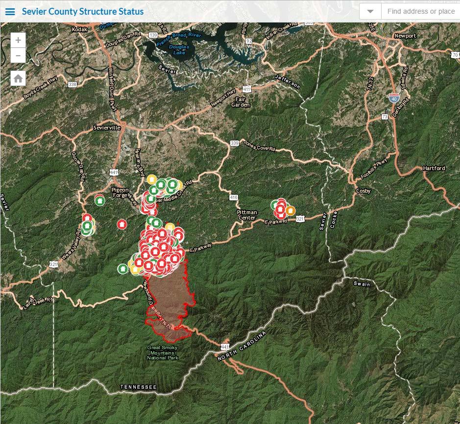
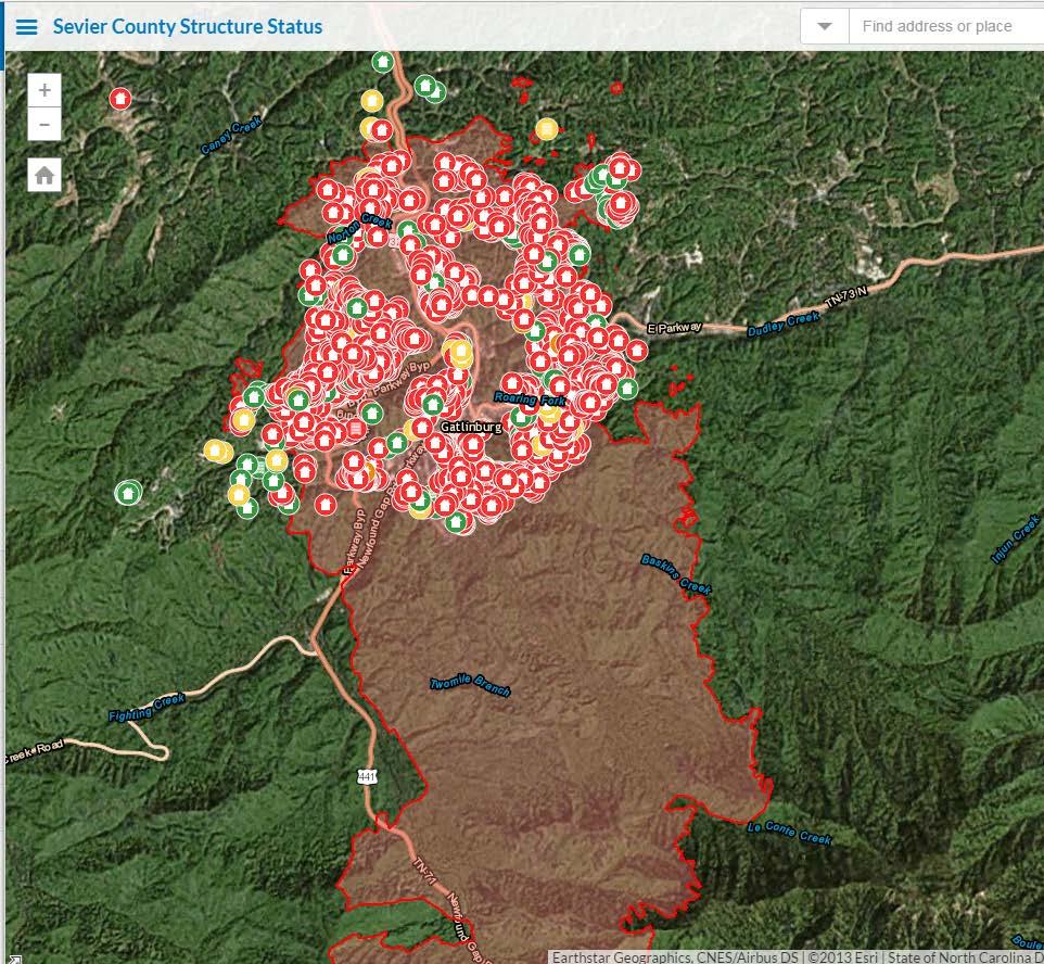
4 The impact of the high winds on the 28 th of November was to rapidly spread the fires in eastern Tennessee. The rapidly spreading Chimney Tops 2 fire produced massive destruction in and around Gatlinburg, TN (CNN 2016). There were numerous other fires. The fires led to at least 14 fatalities, destroyed over 44,000 acres of woodlands, and destroyed entire neighborhoods in and around Gatlinburg and other lesser known towns. The fires were the result of dry conditions and people setting fires which either escaped them or were deliberated set. The dry conditions, the fires, and then the high wind event resulted in regional disaster. As of 9 December 2016 the Chimney Tops 2 fire was about 90% contained and had not been completely extinguished by the rain. The Chimney Tops 2 fire was likely resulted in 14 deaths and the destruction of over 700 homes and other structures. The drought had significant agricultural impact. The dry conditions limited hay production causing a regional hay shortage and has reduced the availability of water for animals and other activities. The heavy rain on 29 and 30 November led to flooding in portions of Alabama. The rains also aided in controlling and extinguishing most of the fires. The severe storms on November produced 10 fatalities and multiple injuries. Most of the strong tornado activity was in Alabama and portions of Tennessee. The pattern changed dramatically in the southeastern United States. This change produced a meteorologically and climatologically significant high wind event, rainfall event, and severe weather event. The winds caused rapid spreading fires which likely contributed to the impact of this event.. 4. Conclusions The autumn of 2016 was very warm and dry over the southeastern United States (Fig. 1) due to the persistent ridge which extended from the Gulf of Mexico into central Canada. This feature dominated until about 28 November 2016 (Fig. 3) when there was a relatively abrupt pattern change (Fig. 4). The strong frontal system with this abrupt change produced strong winds in the warm sector which rapidly spread fires in eastern Tennessee November The strong front triggered severe weather and tornadoes, and a heavy rainfall. The strong frontal system which caused the high winds, heavy rainfall and the severe weather event was relatively well predicted by the NCEP GEFS. With at least 4 days of lead-time the GEFS showed both the potential for strong winds over the southern Appalachians and a multiday rain event which was forecast to produce 25 to 50 mm or rainfall. Observations imply the GEFS underestimated the total rainfall. But the GEFS had a useful signal for both events. Though not shown, the GEFS also provided clues with high PW air, high CAPE, and shear for a severe weather event. 4
5 Parameter/Threshold Tri-Cities/Bristol-Johnson City Area (KTRI) Knoxville Area (KTYS) Chattanooga Area (KCHA) Sept observed Sept normal Oct observed Oct normal Nov month to date observed as of midnight 11/ Nov normal month to date as of midnight 11/ Sept-Nov observed as of midnight 11/ Normal Sept-Nov as of midnight 11/ Oct-Nov observed as of midnight 11/ Normal Oct-Nov as of midnight 11/ Year to date observed as of midnight 11/ Normal year to date as of midnight 11/ Current (as of midnight 12/4) year to date Normal (as of midnight 12/4) year to date Table 1. List of rainfall amounts (inches) at 3 locations in eastern Tennessee. These data show the significant rainfall deficit at each location. Each location was running a deficit of 10 or more inches through 27 November The data also show that as of 4 December each location had made up at least 4 inches of the rainfall deficit. Shorter range forecasts from the NCAR 3km ensemble showed that this ensemble forecast system provided incredibly detailed, timely, and accurate information related to the high wind event. These high wind forecasts were in the correct time window and focused over the region where the fires were present. This historic high wind, fire, rainfall, and severe weather event over the southern Appalachians was the result of an odd convergence of circumstances. These included the persistent ridge from September into late November. This feature reduced the rainfall and produced drought conditions. A strong trough associated with a pattern change of North America brought strong winds into the dry region. The winds accelerated fire growth. The frontal system eventually brought moderate to heavy rainfall to the region. The rainfall put a significant dent in the rainfall deficits and extinguished many of the fires 2. And for good measure the stronger of two fronts produced a significant severe weather event which included deadly tornadoes. 5. References Galarneau, T. J., Jr., L. F. Bosart, and A. R. Aiyyer, 2008: Closed anticyclones of the subtropics and midlatitudes: A 54-yr climatology ( ) and three case studies. Synoptic Dynamic Meteorology and Weather Analysis and Forecasting: A Tribute to Fred Sanders, Meteor. Monogr., No. 55, Amer. Meteor. Soc., As of 9 December the Chimney tops 2 Fire was 91% controlled. 5
 500 hpa heights, b) 850 hpa temperatures, c) mean sea-level pressure, and d) precipitable water. Return to text.")
6 Figure 1. The composite pattern and the anomalies in the pattern over the 3 month period from 1 September 2016 to 30 November Data include the a) 500 hpa heights, b) 850 hpa temperatures, c) mean sea-level pressure, and d) precipitable water. Return to text. 6

7 7 Figure 2. Upper panel shows the total QPE from the 6-hourly Stage-IV data from 0000 UTC 1 September 2016 through 1200 UTC 28 November The lower panel ends at 1800 UTC 30 November. Return to text.

8 Figure 3. As in Figure 1 except for the period of 0000 UTC 1 November through 0000 UTC 1 December Return to text. 8

9 Figure 4. As in Figure 3 except the mean pattern for the period of 1200 UTC 29 November through 1200 UTC 1 December Return to text. 9
 1200")
10 Figure 5. The CFSR 850 hpa winds for the 6-hour periods from a) 1200 UTC to f) 1800 UTC 29 November Return to text. 10
11 Figure 6. As in Figure 5 except for 850 hpa winds and v-wind anomalies. Return to text. 11
12 Figure 7. As in Figure 6 except for 850 hpa temperatures and temperature anomalies. Return to text. 12

13 Figure 8. As in Figure 7 except for precipitable water and precipitable water anomalies. Return to text. 13
14 Figure 9. As in Figure 7 except for 850 hpa temperatures every 12 hours from a) 0000 UTC 29 November through f) 1200 UTC 01 December Return. 14

15 Figure 10. As in Figure 9 but the total QPE for the period from 1200 UTC 28 November through 1200 UTC 01 November Values as in the color bar. Contours in powers of 2. Return to text. 15

16 Figure 11. Storm Prediction Center storm reports by time for the 28 th and 29 th of November Return to text. 16
17 Figure 12. GEFS forecasts of 850 hpa winds (ms-1) and v-wind anomalies valid at 0000 UTC 29 November Forecasts initialized at a) 1200 UTC 25 November, b) November, c) 1200 UTC 26 November, d) 0000 UTC 27 November, e) 1200 UTC 27 November, and f) 1200 UTC 28 November Return to text. 17
18 Figure 13. As in Figure 12 except valid at 0600 UTC 29 November Return to text. 18

19 Figure 14. As in Figure 12 except valid at 925 hpa winds and v-wind anomalies. Return to text. 19

20 Figure 15. As in Figure 12 except for the GEFS potential for 50 mm or more QPF for the 48 hour period ending at 1200 UTC 1 December Return to text. 20

21 Figure 16. As in Figure 15 except for the ensemble mean precipitation and each member s 50 mm contour if forecast. The thick black contour is the mean 50 mm contour from the ensemble. Return to text. 21
22 Figure 17. NCAR 3km ensemble initialized at 0000 UTC 28 November 2016 showing the probability of the hourly maximum wind speed exceeding 20 ms-1 within 25 miles of a grid point. The times show the first threat time at 1600 UTC 29 November, the height of the event at 0000 and 0600 UTC and the end of the forecast event at 1200 UTC. Images courtesy of NCAR. Return to text. 22
23 Appendix I: Knoxville Observations during the synoptic high wind period: PK WND dddff(f)/(hh)mm :48 METAR KTYS Z 23008KT 4SM RA BR SCT008 OVC043 14/12 A2973 RMK AO2 PRESRR P0024 $ = :29 METAR KTYS Z 27012G18KT 3SM +RA BR OVC007 14/13 A2971 RMK AO2 P0019 T $ = :10 METAR KTYS Z 28010KT 2 1/2SM +RA BR BKN008 BKN014 OVC046 14/13 A2971 RMK AO2 P0008 T $ = :07 METAR KTYS Z 28014KT 3SM +RA BR SCT008 BKN014 OVC046 14/13 A2971 RMK AO2 P0005 T $ = :53 METAR KTYS Z 29015KT 10SM -RA FEW031 OVC047 16/13 A2969 RMK AO2 PRESRR SLP048 P0004 T $ = :53 METAR KTYS Z 20010G22KT 7SM -RA SCT049 OVC060 17/12 A2965 RMK AO2 PK WND 19030/0524 RAB25 SLP032 P T $ = :53 METAR KTYS Z 19019G33KT 10SM FEW055 SCT075 SCT110 OVC250 18/10 A2960 RMK AO2 PK WND 19033/0451 RAE26 SLP020 P0000 T $ = :53 METAR KTYS Z 17018G29KT 10SM -RA SCT055 BKN090 BKN110 OVC250 16/11 A2965 RMK AO2 PK WND 18038/0254 SLP036 P0006 T $ = :53 METAR KTYS Z 19030G42KT 8SM -RA BKN050 BKN070 OVC090 18/11 A2966 RMK AO2 PK WND 18043/0220 RAB36 SLP039 P T = :53 METAR KTYS Z 18021G38KT 10SM BKN065 OVC150 19/08 A2962 RMK AO2 PK WND 16042/0124 SLP026 T = :53 METAR KTYS Z 18025G32KT 10SM FEW065 BKN110 OVC250 19/07 A2964 RMK AO2 PK WND 17032/0053 SLP033 T = :53 METAR KTYS Z 18016G31KT 10SM FEW060 SCT120 OVC250 19/07 A2965 RMK AO2 PK WND 20031/2345 SLP038 T = :53 METAR KTYS Z 15006KT 10SM FEW060 BKN120 OVC250 17/06 A2968 RMK AO2 PK WND 14026/2159 SLP047 T = :53 METAR KTYS Z 16020G33KT 10SM FEW060 BKN150 OVC250 18/06 A2972 RMK AO2 PK WND 18033/2144 PRESFR SLP060 T = :53 METAR KTYS Z 17018G27KT 10SM FEW060 BKN150 BKN250 18/05 A2977 RMK AO2 PK WND 18036/2011 SLP078 T = :53 METAR KTYS Z 17021G28KT 10SM FEW060 SCT150 BKN250 19/06 A2979 RMK A02 PK WND 16038/1943 SLP084 T = :53 METAR KTYS Z 18020G34KT 10SM FEW050 SCT170 BKN250 18/06 A2983 RMK AO2 PK WND 18036/1841 SLP097 T = :53 METAR KTYS Z 20010KT 160V220 10SM FEW049 SCT170 OVC250 17/04 A2986 RMK AO2 SLP110 T = :53 METAR KTYS Z 02005KT 8SM FEW049 BKN140 BKN200 11/01 A2993 RMK AO2 SLP134 T = Convective High Winds 30 November: :53 METAR KTYS Z 21016G28KT 3SM VCTS +RA BR SCT040CB BKN070 OVC100 16/14 A2976 RMK AO2 PK WND 27045/1026 WSHFT 1017 LTG DSNT ALQDS RAB0954E01B21 TSB23E52 SLP069 FRQ LTGIC VC N-E-S TS VC N-E-S MOV NE P0032 T $ = :38 METAR KTYS Z 22024G30KT 3SM +TSRA BR BKN037CB BKN050 OVC070 17/15 A2976 = :31 METAR KTYS Z 24021G45KT 1 1/2SM +TSRA BR SCT045CB BKN060 OVC100 16/14 A2976 RMK AO2 PK WND 27045/1026 WSHFT 1017 LTG DSNT ALQDS RAB0954E01B21 TSB23 FRQ LTGIC OHD TS OHD MOV NE P0000 T $ = :27 METAR KTYS Z 26034G45KT 1/2SM +TSRA SCT045CB BKN060 OVC100 19/16 A2978 RMK AO2 PK WND 27045/1026 LTG DSNT ALQDS RAB0954E01B21 TSB23 PRESRR FRQ LTGIC OHD TS OHD MOV NE P0000 T RVRNO $ = :23 METAR KTYS Z 25022G26KT 10SM -TSRA SCT045CB BKN060 OVC100 21/16 A2975 RMK AO2 PK WND 25026/1023 LTG DSNT ALQDS RAB0954E01B21 TSB23 PRESRR FRQ LTGIC OHD TS OHD MOV NE P0000 T $ = 23
24 24
25 The National Park Service has wind sensors within the bounds of GSMNP. Samples of the wind sensors in the fire regions. Values in ms-1. 25
Impacts of the April 2013 Mean trough over central North America
 Impacts of the April 2013 Mean trough over central North America By Richard H. Grumm National Weather Service State College, PA Abstract: The mean 500 hpa flow over North America featured a trough over
Southern Heavy rain and floods of 8-10 March 2016 by Richard H. Grumm National Weather Service State College, PA 16803
 Southern Heavy rain and floods of 8-10 March 2016 by Richard H. Grumm National Weather Service State College, PA 16803 1. Introduction Heavy rains (Fig. 1) produced record flooding in northeastern Texas
Minor Winter Flooding Event in northwestern Pennsylvania January 2017
 1. Overview Minor Winter Flooding Event in northwestern Pennsylvania 12-13 January 2017 By Richard H. Grumm National Weather Service State College, PA A combination of snow melt, frozen ground, and areas
Pre-Christmas Warm-up December 2013-Draft
 Pre-Christmas Warm-up 21-23 December 2013-Draft By Richard H. Grumm National Weather Service State College, PA 1. Overview A large ridge over the west-central Atlantic (Fig.1) and trough moving into eastern
Heavy Rainfall Event of June 2013
 Heavy Rainfall Event of 10-11 June 2013 By Richard H. Grumm National Weather Service State College, PA 1. Overview A 500 hpa short-wave moved over the eastern United States (Fig. 1) brought a surge of
Heavy rains and precipitable water anomalies August 2010 By Richard H. Grumm And Jason Krekeler National Weather Service State College, PA 16803
 Heavy rains and precipitable water anomalies 17-19 August 2010 By Richard H. Grumm And Jason Krekeler National Weather Service State College, PA 16803 1. INTRODUCTION Heavy rain fell over the Gulf States,
National Weather Service-Pennsylvania State University Weather Events
 National Weather Service-Pennsylvania State University Weather Events Heavy rainfall of 23 November 2011 by Richard H. Grumm National Weather Service State College PA 16803 Abstract:. A fast moving mid-tropospheric
Early May Cut-off low and Mid-Atlantic rains
 Abstract: Early May Cut-off low and Mid-Atlantic rains By Richard H. Grumm National Weather Service State College, PA A deep 500 hpa cutoff developed in the southern Plains on 3 May 2013. It produced a
Mid-Atlantic Ice Storm 4 March 2015
 1. Overview Mid-Atlantic Ice Storm 4 March 2015 By Richard H. Grumm National Weather Service State College, PA A large 500 hpa ridge over the southern United States (Fig. 1a-e)) built into the Mid-Atlantic
National Weather Service-Pennsylvania State University Weather Events
 National Weather Service-Pennsylvania State University Weather Events Abstract: Tropical Storm Debbie, standardized anomalies and heavy rainfall by Richard H. Grumm National Weather Service State College
Mid Atlantic Severe Event of 1 May 2017 Central Pennsylvania QLCS event By Richard H. Grumm National Weather Service, State College, PA 16803
 1. Overview Mid Atlantic Severe Event of 1 May 2017 Central Pennsylvania QLCS event By Richard H. Grumm National Weather Service, State College, PA 16803 A strong upper-level wave (Fig.1) moving into a
Indiana County Flash Flood of 22 June 2017
 Indiana County Flash Flood of 22 June 2017 By Richard H. Grumm National Weather Service State College, PA 1. Overview Slow moving thunderstorms brought 3 to 4 inches of rainfall to Indiana County, PA during
Southern United States Winter Storm of 28 January 2014-v1. High Impact Snow on Edge of Forecast Precipitation Shield
 Southern United States Winter Storm of 28 January 2014-v1 High Impact Snow on Edge of Forecast Precipitation Shield by Richard H. Grumm National Weather Service State College, PA 16803 and 1. Introduction
Tropical Storm Hermine: Heavy rainfall in western Gulf By Richard H. Grumm National Weather Service Office State College, PA 16803
 Tropical Storm Hermine: Heavy rainfall in western Gulf By Richard H. Grumm National Weather Service Office State College, PA 16803 1. INTRODUCTION Tropical storm Hermine, the eighth named tropical system
Multi-day severe event of May 2013
 Abstract: Multi-day severe event of 18-22 May 2013 By Richard H. Grumm and Charles Ross National Weather Service State College, PA A relatively slow moving Trough over the western United States and a ridge
Winter Storm of 15 December 2005 By Richard H. Grumm National Weather Service Office State College, PA 16803
 Winter Storm of 15 December 2005 By Richard H. Grumm National Weather Service Office State College, PA 16803 1. INTRODUCTION A complex winter storm brought snow, sleet, and freezing rain to central Pennsylvania.
Northeastern United States Snowstorm of 9 February 2017
 Northeastern United States Snowstorm of 9 February 2017 By Richard H. Grumm and Charles Ross National Weather Service State College, PA 1. Overview A strong shortwave produced a stripe of precipitation
Eastern United States Wild Weather April 2014-Draft
 1. Overview Eastern United States Wild Weather 27-30 April 2014-Draft Significant quantitative precipitation bust By Richard H. Grumm National Weather Service State College, PA and Joel Maruschak Over
Southern Plains Heavy rain and Flooding
 Abstract: Southern Plains Heavy rain and Flooding By Richard H. Grumm National Weather Service State College, PA A severe weather event affected the southern Plains on 31 May 2013. The severe weather event
Southern United States Heavy rain and flood event 6-8 April 2014
 Southern United States Heavy rain and flood event 6-8 April 2014 By Richard H. Grumm National Weather Service State College, PA 1. Overview Heavy rainfall (Fig. 1) affected the southern United States from
Mid-West Heavy rains 18 April 2013
 Abstract: Mid-West Heavy rains 18 April 2013 By Richard H. Grumm and Charles Ross National Weather Service State College, PA The relatively wet conditions during the first 16 days of April 2013 set the
Hurricane Harvey the Name says it all. by Richard H. Grumm and Charles Ross National Weather Service office State College, PA
 Hurricane Harvey the Name says it all by Richard H. Grumm and Charles Ross National Weather Service office State College, PA 16803. 1. Overview Hurricane Harvey crossed the Texas coast (Fig. 1) as a category
2 July 2013 Flash Flood Event
 2 July 2013 Flash Flood Event By Richard H. Grumm and Charles Ross National Weather Service State College, PA 1. Overview A retrograding 500 hpa cyclone and anticyclone (Fig. 1) set up deep southerly flow
Severe Weather with a strong cold front: 2-3 April 2006 By Richard H. Grumm National Weather Service Office State College, PA 16803
 Severe Weather with a strong cold front: 2-3 April 2006 By Richard H. Grumm National Weather Service Office State College, PA 16803 1. INTRODUCTION A strong cold front brought severe weather to much of
The enduring Louisiana rain and flooding of August 2016 by Richard H. Grumm National Weather Service State College, PA 16803
 1. Introduction The enduring Louisiana rain and flooding of August 2016 by Richard H. Grumm National Weather Service State College, PA 16803 Historic flooding impacted Louisiana on 12-15 August 2016 (TWC
National Weather Service-Pennsylvania State University Weather Events
 National Weather Service-Pennsylvania State University Weather Events Eastern United States Winter Storm and Severe Event of 28-29 February 2012 by Richard H. Grumm National Weather Service State College
1. INTRODUCTION. For brevity times are referred to in the format of 20/1800 for 20 August UTC. 3. RESULTS
 Heavy rains and precipitable water anomalies 20-23 August 2010-Draft By Jason Krekeler And Richard Grumm National Weather Service State College, PA 16803 1. INTRODUCTION Heavy rain fell across the central
Warm Episode of December 2015:
 Warm Episode of 11-16 December 2015: Record Warmth over Mid-Atlantic Region By Richard H. Grumm National Weather Service State College, PA 1. Overview A strong 500 hpa ridge over the eastern United States
1. INTRODUCTION. In addition to the severe weather, the
 Anomalous Low and its weather impacts 10-12 May 2008 By Richard Grumm National Weather Service Office State College, PA And Al Cope National Weather Service Office Mount Holly, NJ 1. INTRODUCTION An unusually
Snow, freezing rain, and shallow arctic Air 8-10 February 2015: NCEP HRRR success story
 Snow, freezing rain, and shallow arctic Air 8-10 February 2015: NCEP HRRR success story By Richard H. Grumm National Weather Service State College, PA 1. Overview A short-wave (Fig. 1) moved over the strong
The enduring fog and low cloud episode of 5-10 December 2015: Big Bubble Fog Trouble
 1. Overview The enduring fog and low cloud episode of 5-10 December 2015: Big Bubble Fog Trouble By Richard H. Grumm National Weather Service State College, PA An enduring low cloud and fog episode affected
National Weather Service-Pennsylvania State University Weather Events
 National Weather Service-Pennsylvania State University Weather Events Abstract: West Coast Heavy Precipitation Event of January 2012 by Richard H. Grumm National Weather Service State College PA 16803
1. INTRODUCTION * Figure 1. National Weather Service Storm Prediction Center (SPC) storm reports for December 1, 2006.
 storm reports for December 1, 2006.") P1.14 FORECAST ISSUES RELATED TO THE UNPRECEDENTED SEVERE AND HIGH WIND EVENT OF DECEMBER 2006 by Greg A. DeVoir* and Richard H. Grumm National Weather Service Office State College, PA 16803 1. INTRODUCTION
P1.14 FORECAST ISSUES RELATED TO THE UNPRECEDENTED SEVERE AND HIGH WIND EVENT OF DECEMBER 2006 by Greg A. DeVoir* and Richard H. Grumm National Weather Service Office State College, PA 16803 1. INTRODUCTION
Mid-Atlantic Severe Weather Event of 23 June 2015
 Mid-Atlantic Severe Weather Event of 23 June 2015 By Richard H. Grumm National Weather Service State College, PA 1. Overview A widespread severe weather event occurred in the eastern United States on 23
New Zealand Heavy Rainfall and Floods
 New Zealand Heavy Rainfall and Floods 1. Introduction Three days of heavy rainfall associated with a deep upper-level low (Fig. 1) brought flooding to portions of New Zealand (Fig. 2). The flooding was
National Weather Service-Pennsylvania State University Weather Events
 National Weather Service-Pennsylvania State University Weather Events Historic Ohio Valley January Severe weather and Tornado Event by Richard H. Grumm National Weather Service State College PA 16803 and
Eastern United States Anafrontal Snow 4-5 March 2015-Draft
 Eastern United States Anafrontal Snow 4-5 March 2015-Draft By Richard H. Grumm National Weather Service State College, PA 1. Overview A 500 hpa ridge over the western Atlantic (Fig. 1) and an approaching
Mid Atlantic Heavy rainfall event 1. Overview 2. Methods and Data 3. Pattern
 1. Overview Mid Atlantic Heavy rainfall event With an inertial gravity wave? By Richard H. Grumm National Weather Service, State College, PA 16803 Contributions from the Albany MAP An unseasonably strong
2. Methods and data. 1 NWS Reno, NV report circulated in the LA Times story maximum wind was observed at 0900 AM 8 January 2017.
 The California Extreme Precipitation Event of 8-10 January 2017 By Richard H. Grumm and Charles Ross National Weather Service State College, PA 16803 1. Introduction A strong Pacific jet and a surge of
HRRR and the Mid-Mississippi Valley Severe and Heavy rainfall event of October 2014
 HRRR and the Mid-Mississippi Valley Severe and Heavy rainfall event of 13-14 October 2014 By Richard H. Grumm National Weather Service State College, PA contributions by Charles Ross 1. Overview A deep
A summary of the heat episodes of June 2017
 A summary of the heat episodes of June 2017 By Richard H. Grumm and Elissa A. Smith National Weather Service State College, PA 1. Overview Over 1800 record high temperatures were set or tied during the
Flooding and Severe weather of 27 June 2013
 Flooding and Severe weather of 27 June 2013 By Richard H. Grumm National Weather Service State College, PA 1. Overview Flooding and severe weather affected Pennsylvania on 27 June 2013 (Fig 1). The severe
Cold frontal Rainband and Mid-Atlantic Severe Weather Event 28 September 2006 by Richard H. Grumm And Ron Holmes
 Cold frontal Rainband and Mid-Atlantic Severe Weather Event 28 September 2006 by Richard H. Grumm And Ron Holmes 1. INTRODUCTION A strong cold front moved across central Pennsylvania and the Mid-Atlantic
Heavy Rainfall and Flooding of 23 July 2009 By Richard H. Grumm And Ron Holmes National Weather Service Office State College, PA 16803
 Heavy Rainfall and Flooding of 23 July 2009 By Richard H. Grumm And Ron Holmes National Weather Service Office State College, PA 16803 1. INTRODUCTION Heavy rains fall over Pennsylvania and eastern New
09 December 2005 snow event by Richard H. Grumm National Weather Service Office State College, PA 16803
 09 December 2005 snow event by Richard H. Grumm National Weather Service Office State College, PA 16803 1. INTRODUCTION A winter storm produced heavy snow over a large portion of Pennsylvania on 8-9 December
The Spring Storm of April 2007 By Richard H. Grumm National Weather Service Office State College PA 16803
 The Spring Storm of 13-16 April 2007 By Richard H. Grumm National Weather Service Office State College PA 16803 1. INTRODUCTION A major spring storm struck the eastern United States from 13 through 16
NCEP Short-Range Ensemble forecasts of an historic rainfall event: The June 2006 East Coast Floods 1. INTRODUCTION
 NCEP Short-Range Ensemble forecasts of an historic rainfall event: The 23-27 June 2006 East Coast Floods By Richard H. Grumm National Weather Service Office, State College PA 16803 And Norman W. Junker
National Weather Service-Pennsylvania State University Weather Events
 National Weather Service-Pennsylvania State University Weather Events Heavy Rain 7-8 December 2011 by Richard H. Grumm National Weather Service State College PA 16803 Abstract:. A mid-level short-wave
NWS-PSU Case Study Site 2010 Severe Weather Case
 NWS-PSU Case Study Site 2010 Severe Weather Case New Years Eve Severe Weather Event of 31 December 2010 by Richard H. Grumm National Weather Service State College PA 16083 Abstract: A surge of warm humid
National Weather Service-Pennsylvania State University Weather Events
 National Weather Service-Pennsylvania State University Weather Events New Zealand heavy rain and flood event-draft by Richard H. Grumm National Weather Service State College PA 16803 Abstract:. A record
Low-end derecho of 19 August 2017
 Low-end derecho of 19 August 2017 By Richard H. Grumm and Charles Ross National Weather Service State College, PA 1. Overview A cluster of thunderstorms developed in eastern Ohio around 1800 UTC on 19
Deep Cyclone and rapid moving severe weather event of 5-6 June 2010 By Richard H. Grumm National Weather Service Office State College, PA 16803
 Deep Cyclone and rapid moving severe weather event of 5-6 June 2010 By Richard H. Grumm National Weather Service Office State College, PA 16803 1. INTRODUCTION A rapidly deepening surface cyclone raced
National Weather Service-Pennsylvania State University Weather Events
 National Weather Service-Pennsylvania State University Weather Events The southern Express: High Impact Spring Storm of 14-17 April 2011 by Richard H. Grumm National Weather Service State College PA 16803
Heat wave ending severe events of July 2010 By Richard H. Grumm National Weather Service Office State College, PA 16803
 Heat wave ending severe events of 23-25 July 2010 By Richard H. Grumm National Weather Service Office State College, PA 16803 1. INTRODUCTION A strong subtropical ridge (Fig. 1a) dominated the eastern
Eastern United States Ice Storm of December 2008 By Richard H. Grumm National Weather Service State College, PA 16803
 Eastern United States Ice Storm of 11-12 December 2008 By Richard H. Grumm National Weather Service State College, PA 16803 1. INTRODUCTION A significant ice storm affected the eastern United States on
Historic Central Pennsylvania Flash Floods of 21 October 2016 by Richard H. Grumm National Weather Service State College, PA 16803
 1. Introduction Historic Central Pennsylvania Flash Floods of 21 October 2016 by Richard H. Grumm National Weather Service State College, PA 16803 A slow moving frontal system produced heavy rainfall in
Convective Heavy rainfall event of 23 July 2013
 Convective Heavy rainfall event of 23 July 2013 By Richard H. Grumm and Charles Ross National Weather Service State College, PA Abstract: A record rain event affected southern Lebanon County on 23 July
This paper will document the pattern which produced the record rainfall of 30 September The goal is to show the pattern the
 The Historic Synoptic-Hybrid rainfall event 30 September 2010 By Richard Grumm And Michael Kozar National Weather Service State College, PA 16803 1. INTRODUCTION A slow moving north-south oriented frontal
Recent Trends in Northern and Southern Hemispheric Cold and Warm Pockets
 Recent Trends in Northern and Southern Hemispheric Cold and Warm Pockets Abstract: Richard Grumm National Weather Service Office, State College, Pennsylvania and Anne Balogh The Pennsylvania State University
Thanksgiving Eve snow of November 2014
 1. Overview Thanksgiving Eve snow of 26-27 November 2014 By Richard H. Grumm National Weather Service State College, PA An early season east coast winter storm (ECWS: DeGaetano et al. 2002) brought snow
1. INTRODUCTION. The super storm of March 1993 produced severe weather and tornadoes as it s trailing cold front pushed through Florida (Kocin eta 1l
 1. INTRODUCTION Super Tuesday and awful Wednesday: the 5-6 February 2008 Severe Weather Outbreak By Richard H. Grumm National Weather Service State College, PA And Seth Binau National Weather Service,
The Long-lived eastern US tornadic supercell of 20 July 2017
 1. Overview The Long-lived eastern US tornadic supercell of 20 July 2017 By Richard H. Grumm and Elissa A Smith National Weather Service State College, PA A long lived supercell developed near the eastern
Warm Episode over Indian Sub-continent March 2010 By Richard Grumm National Weather Service State College Contributions by Lance Bosart SUNY Albany
 Warm Episode over Indian Sub-continent March 2010 By Richard Grumm National Weather Service State College Contributions by Lance Bosart SUNY Albany 1. INTRODUCTION A massive subtropical ridge formed over
Pennsylvania Severe Weather of September 2016
 Pennsylvania Severe Weather of September 2016 By Richard H. Grumm National Weather Service State College, PA 1. Overview September 2016 was a relatively quiet month for severe weather across most of the
Southeastern Texas historic rain of 18 April 2016 by Richard H. Grumm and Charles Ross National Weather Service State College, PA 16803
 Southeastern Texas historic rain of 18 April 2016 by Richard H. Grumm and Charles Ross National Weather Service State College, PA 16803 1. Introduction Extremely heavy rainfall across southeastern Texas
Memorial Day Weekend 2013: Snow and Cold
 Abstract: Memorial Day Weekend 2013: Snow and Cold By Richard H. Grumm National Weather Service State College, PA A slow moving 500 hpa low and associated unseasonably cold air in the lower troposphere
KEY TO DECODING THE U.S. METAR OBSERVATION REPORT
 KEY TO DECODING THE U.S. METAR OBSERVATION REPORT Example METAR Report METAR KABC 121755Z AUTO 21016G24KT 180V240 1SM R11/P6000FT -RA BR BKN015 0VC025 06/04 A2990 RMK A02 PK WND 20032/25 WSHFT 1715 VIS
Early Summer Heat Waves of 2013
 Early Summer Heat Waves of 2013 Abstract: By Richard H. Grumm National Weather Service State College, PA And Trevor Alcott National Weather Service, Salt Lake City Utah From late June into mid-july large
ERTH 465 Fall Laboratory Exercise 5. Surface Weather Observations (METARS) and Frontal Analysis (300 pts)
 and Frontal Analysis (300 pts)") ERTH 465 Fall 2017 Laboratory Exercise 5 Surface Weather Observations (METARS) and Frontal Analysis (300 pts) Insert in ringed-three hole binder. Point deductions for sloppy or late work. Due date: Tuesday
ERTH 465 Fall 2017 Laboratory Exercise 5 Surface Weather Observations (METARS) and Frontal Analysis (300 pts) Insert in ringed-three hole binder. Point deductions for sloppy or late work. Due date: Tuesday
Mid-Atlantic Derecho event of 29 June 2012
 Mid-Atlantic Derecho event of 29 June 2012 Richard H. Grumm Charles H. Ross And Elyse Colbert National Weather Service Office State College, PA 16803 1. Overview An area of convection developed over eastern
Eastern United States Winter Storm of 1-2 February 2015-DRAFT Northeast Ground Hog Storm
 Eastern United States Winter Storm of 1-2 February 2015-DRAFT Northeast Ground Hog Storm By Richard H. Grumm National Weather Service State College, PA 1. Overview A major Winter Storm brought precipitation
The Devastating Western European Winter Storm February 2010 By Richard H. Grumm National Weather Service
 The Devastating Western European Winter Storm 27-28 February 2010 By Richard H. Grumm National Weather Service 1. INTRODUCTION A strong late winter storm, called Xynthia 1, raced across Western Europe
1. INTRODUCTION. March. Local time used in text to define dates. 1 Due to UTC time the went passed 0000 UTC 31
 New England Record Maker Rain Event of 29-30 March 2010 By Richard H. Grumm National Weather Service Contributions by Frank Nocera National Weather Service Office Taunton, MA 1. INTRODUCTION The second
Winter Storm of February 2008 By Richard H. Grumm National Weather Service Office State College PA 16803
 1. INTRODUCTION Winter Storm of 11-13 February 2008 By Richard H. Grumm National Weather Service Office State College PA 16803 A potent winter storm brought snow, sleet, freezing rain, and rain to the
Patterns of Heavy rainfall in the Mid-Atlantic Region 1. INTRODUCTION
 5A.2 Patterns of Heavy rainfall in the Mid-Atlantic Region by Richard H. Grumm * And Ron Holmes National Weather Service Office State College, PA 16802 1. INTRODUCTION The patterns associated with heavy
Severe Weather Event of 13 July 2014
 Severe Weather Event of 13 July 2014 By Richard H. Grumm and Elyse M. Colbert National Weather Service State College, PA 1. Overview Severe weather affected the eastern United States (Fig. 1) from northwestern
The Devastating Mid-Mississippi Valley Floods of 1-2 May 2010 By Richard H. Grumm National Weather Service
 The Devastating Mid-Mississippi Valley Floods of 1-2 May 2010 By Richard H. Grumm National Weather Service 1. INTRODUCTION A devastating heavy rainfall event affected the Mid-Mississippi Valley (MMV) from
Historic Eastern United States Winter Storm of January 2016: Record snow along the megalopolitan corridor 1. Introduction
 Historic Eastern United States Winter Storm of 22-24 January 2016: Record snow along the megalopolitan corridor by Richard H. Grumm National Weather Service State College, PA 16803 1. Introduction An historic
1. INTRODUCTION. Hellström, SMHI. This includes all record highs and dates for Sweden. 2 Data provided by Jari Tuovinen, Helsinki, Finland.
 European Heat Event of July 2010 By Richard H. Grumm National Weather Service State College, PA 16803 Contributions by Jari Tuovinen Finnish Meteorological Institute 1. INTRODUCTION A significant heat
ERTH 465 Fall Laboratory Exercise 5. Surface Weather Observations (METARS) and Frontal Analysis (300 pts)
 and Frontal Analysis (300 pts)") ERTH 465 Fall 2017 Laboratory Exercise 5 Surface Weather Observations (METARS) and Frontal Analysis (300 pts) Insert in ringed-three hole binder. Point deductions for sloppy or late work. Due date: Tuesday
ERTH 465 Fall 2017 Laboratory Exercise 5 Surface Weather Observations (METARS) and Frontal Analysis (300 pts) Insert in ringed-three hole binder. Point deductions for sloppy or late work. Due date: Tuesday
The Deep South snowfall of February 2010 By Richard H. Grumm National Weather Service Office, State College, PA 16803
 The Deep South snowfall of 11-13 February 2010 By Richard H. Grumm National Weather Service Office, State College, PA 16803 1. INTRODUCTION A surface cyclone tracked across Mexico and the Gulf of Mexico
National Weather Service-Pennsylvania State University Weather Events
 National Weather Service-Pennsylvania State University Weather Events The high latitude Eurasian Anticyclone of January-February 2012 by Richard H. Grumm National Weather Service State College PA 16803
Alaskan heat episode of June 2013-Draft
 Alaskan heat episode of 16-19 June 2013-Draft Abstract: By Trevor Alcott National Weather Service Western Region, Salt Lake City UT And Richard H. Grumm National Weather Service State College, PA A strong
The North American Heat Wave of July 2011-Draft
 The North American Heat Wave of July 2011-Draft By Richard H. Grumm And Jason Krekeler 328 Innovation Blvd Suite 330 National Weather Service Office State College, PA 16803 The meteorological conditions
Eastern Derecho June 2013-Draft
 Abstract: Eastern Derecho 12-13 June 2013-Draft Richard H. Grumm National Weather Service Office State College, PA 16803 A strong mid-tropospheric short-wave coming over a sharp 500 hpa ridge produced
The Severe Weather Event of 7 August 2013 By Richard H. Grumm and Bruce Budd National Weather Service State College, PA 1. INTRODUCTION and Overview
 The Severe Weather Event of 7 August 2013 By Richard H. Grumm and Bruce Budd National Weather Service State College, PA 1. INTRODUCTION and Overview A fast moving short-wave (Fig. 1) with -1σ 500 hpa height
End of heat-event severe event of 7 July 2012
 End of heat-event severe event of 7 July 2012 Richard H. Grumm And Elyse Colbert National Weather Service Office State College, PA 16803 1. Overview A widespread severe weather event affected Pennsylvania
Devastating Tornadoes of 22 May 2011-Draft by Richard H. Grumm National Weather Service State College, PA
 Abstract: Devastating Tornadoes of 22 May 2011-Draft by Richard H. Grumm National Weather Service State College, PA A series of tornadoes struck the central United States on Sunday 22 May 2011. Tornadoes
5A.3 THE USE OF ENSEMBLE AND ANOMALY DATA TO ANTICIPATE EXTREME FLOOD EVENTS IN THE NORTHEASTERN U.S.
 5A.3 THE USE OF ENSEMBLE AND ANOMALY DATA TO ANTICIPATE EXTREME FLOOD EVENTS IN THE NORTHEASTERN U.S. Neil A. Stuart(1), Richard H. Grumm(2), John Cannon(3), and Walt Drag(4) (1)NOAA/National Weather Service,
Thanksgiving Snow and Arctic Front 25 November 2005 By Richard H. Grumm National Weather Service State College, PA 16801
 Thanksgiving Snow and Arctic Front 25 November 2005 By Richard H. Grumm National Weather Service State College, PA 16801 1. INTRODUCTION An approaching arctic front brought light snow to most of western
1995 and 1980 (exact dates would be useful). 1. INTRODUCTION
. 1. INTRODUCTION") Alaskan Autumn Storm of 22-24 November 2010 By Richard Grumm National Weather Service State College, PA 16803 and Rick Thoman and James A. Nelson National Weather Service Alaska Region 1. INTRODUCTION
Alaskan Autumn Storm of 22-24 November 2010 By Richard Grumm National Weather Service State College, PA 16803 and Rick Thoman and James A. Nelson National Weather Service Alaska Region 1. INTRODUCTION
National Wildland Significant Fire Potential Outlook
 National Wildland Significant Fire Potential Outlook National Interagency Fire Center Predictive Services Issued: September, 2007 Wildland Fire Outlook September through December 2007 Significant fire
Isolated severe weather and cold air damming 9 November 2005 By Richard H. Grumm National Weather Service Office State College, PA 16801
 Isolated severe weather and cold air damming 9 November 2005 By Richard H. Grumm National Weather Service Office State College, PA 16801 1. INTRODUCTION Two lines of convection moved over the State of
The historic warm episode of February 2017
 The historic warm episode of February 2017 By Richard H. Grumm National Weather Service State College, PA 1. Overview A winter warm episode brought an extended period of record and near record warmth to
Appalachian Lee Troughs and their Association with Severe Thunderstorms
 Appalachian Lee Troughs and their Association with Severe Thunderstorms Daniel B. Thompson, Lance F. Bosart and Daniel Keyser Department of Atmospheric and Environmental Sciences University at Albany/SUNY,
Orographically enhanced heavy rainfall of 23 May 2010 By Richard H. Grumm National Weather Service Office State College, PA 16803
 Orographically enhanced heavy rainfall of 23 May 2010 By Richard H. Grumm National Weather Service Office State College, PA 16803 1. INTRODUCTION During the overnight hours and into the early morning of
Mesoscale Convective System and heat episode July 2005 by Richard H. Grumm and Mathew Steinbugl
 Mesoscale Convective System and heat episode 25-27 July 2005 by Richard H. Grumm and Mathew Steinbugl 1. INTRODUCTION A strong upper-level ridge brought unseasonably high temperatures to the Midwest and
Monthly Long Range Weather Commentary Issued: May 15, 2014 Steven A. Root, CCM, President/CEO
 Monthly Long Range Weather Commentary Issued: May 15, 2014 Steven A. Root, CCM, President/CEO sroot@weatherbank.com APRIL 2014 REVIEW Climate Highlights The Month in Review The average temperature for
Historic Ellicott City Flood of 30 July Introduction
 Historic Ellicott City Flood of 30 July 2016 by Richard H. Grumm and Norman W. Junker Satellite Contributions by Sheldon Kusselson National Weather Service State College, PA 16803 1. Introduction Intense
The Weather Wire. Contents: Summer 2018 Outlook. Summer 2018 Outlook Drought Monitor May Summary/Statistics June Preview Rainfall Totals
 The Weather Wire June 2018 Volume 25 Number 6 Contents: Summer 2018 Outlook Drought Monitor May Summary/Statistics June Preview Rainfall Totals Summer 2018 Outlook June 1 st marked the first day of meteorological