Yi Liu TanSat Science Team
|
|
|
- Aleesha McKenzie
- 5 years ago
- Views:
Transcription


1 12th International Workshop on Greenhouse Gas Measurements from Space The Pre Launch Status of TanSat Mission Yi Liu TanSat Science Team Institute of Atmospheric Physics, Chinese Academy of Sciences 9 June 2016 Kyoto University, Japan


2 Our journey of IWGGMS 7 to 12 IWGGMS-11 IWGGMS-9 IWGGMS-7 IWGGMS-12 IWGGMS-10 IWGGMS
3 Outline 1. TanSat Mission 2. Satellite platform & Payload Current Status 3. Retrieval algorithm XCO2 and CO2 Flux inversion 4. Ground based validation 5. Schedule and Plan
 (2011 2015) (3) Strategic Priority Research Program Space Science: Scientific Research Satellite")
4 The TanSat Mission (1) National High Technology Research & Development Programs by Ministry of Science and Technology of China (MOST) Term 1 ( ) Term 2 ( ) (2) Strategic Priority Research Program Climate Change: Carbon Budget and Relevant Issue by Chinese Academy of Sciences (CAS) ( ) (3) Strategic Priority Research Program Space Science: Scientific Research Satellite (CAS) ( ) Organization of TanSat Mission Funding Launch Term 1( ) Measurement Goals XCO2 1~4 ppmv Monthly 500 x 500 km 2 Term 2( ) Measurement Goals CO2 Flux Relative flux error 20% Monthly 500 x 500 km 2
5 Team of The TanSat Project Team Leader Zengshan Yin Shanghai Engineering Center for Microsatellites Mission Team leader and Satellite platform Yuquan Zheng Changchun Institute of Optics, Fine Mechanics and Physics Changxiang Yan Changchun Institute of Optics, Fine Mechanics and Physics Zhongdong Yang National Satellite Meteorological Center, CMA Yi Liu Institute of Atmospheric Physics, CAS Xiangjun Tian Institute of Atmospheric Physics, CAS Chengcai Li Beking University Carbon Dioxide Spectrometer Cloud and Aerosol Polarization Imager (CAPI) Data receiver, Calibration and Operational Process Science requirement, CO2 Retrieval Algorithm, Validation and Application CO2 Flux inversion Aerosol and cloud Retrieval Algorithm for CAPI


6 Satellite Platform Observation Mode Name Orbit type Altitude Characters sun synchronous 700 km Inclination 98 Local time 13:30 Weight 500Kg Nadir mode Observation over land Push broom Principle plane track Sun glint mode Observation over ocean Sun glint track Principle plane track Target mode Validation Surface target track Multi angles for one target Nadir mode Target mode Sun glint mode
 O 2 -A CO 2")
 0.038-0.047 0.120-0.")


7 Carbon Dioxide Sensor (CDS) TanSat Instrument Cloud and Aerosol Polarization Imager ( CAPI ) O 2 -A CO 2 Weak CO 2 Strong Spectral Range(nm) Spectral Resolution(nm) SNR Spatial 2kmx2km Resolution Swath 20km Ultraviolet: 0.38μm Visible: 0.67μm Near infrared: 0.87, 1.375, 1.64μm Polarization: 0.67 & 1.64 μm mo 2 A Band CO m Band CO m Band


8 CDS and CAPI Focal Plane Pointing mirror electric box Grating Cover Focal Plane Focal Infrared focal plane electric box Bean splitter Pointer Mirror CAPI Vis Ch Telescope CAPI NIR Ch CAPI Calibr Install support
9 Outline 1. TanSat Mission 2. Satellite platform & Payload Current Status 3. Retrieval algorithm XCO2 and CO2 Flux inversion 4. Ground based validation 5. Schedule and Plan


10 Preflight calibration in laboratory Preflight calibration Radiometric Cal. Spectral Cal. Polarization Cal. Geometric Cal. SNR
11 ILS calibration results O 2 A x 10 4 FOV5Channel900-Channel910 x FOV5Channel FWHM= Centerwave= DN 1 DN Wavelength(nm) CO 2 W FOV5Channel400-Channel delta Wavelength(nm) 1 FOV5Channel FWHM= Centerwave= DN Normalized DN Wavelength(nm) CO 2 S x 10 4 FOV5Channel Delta Wavelength(nm) FOV5Channel128 FWHM= Centerwave= DN Normalized DN Wavelength(nm) Delta Wavelength(nm)
12 Wavelength grid and SNR Wavelength(nm) FOV1 FOV3 FOV5 FOV7 FOV Channel Wavelength(nm) FOV1 FOV3 FOV5 FOV7 FOV Channel Wavelength(nm) FOV1 FOV3 FOV5 FOV7 FOV Channel SNR 均值 SNR 均值 SNR 均值 SNR SNR Mean Mean 304 Mean 185 SNR Channel Channel Channel O 2 Aband CO 2 weak band CO 2 strong band


13 CAPI preflight test Integration of instrument Component Environment test Electronics system Electronics system


14 Preflight instrument integration Thermal test Electronics integration Vibration test


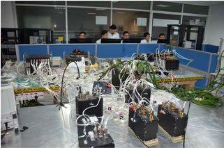
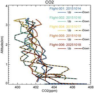
15 Aircraft experiment Flight 1 Flight 2 Flight 3
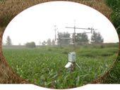
 CDS measurement Collaboration measurement Surface CO2 AOD Balloon")
16 Airborne experiment of CDS (Dr. Yue) CDS measurement Collaboration measurement Surface CO2 AOD Balloon measurement Meteorological Surface albedo
17 Outline 1. TanSat Mission 2. Satellite platform & Payload Current Status 3. Retrieval algorithm 4. Ground based validation 5. Schedule and Plan
 400 Lamont 400 ParkFalls 400 Saga 395 395 395 Validation GOSAT XCO2 (ppmv) 390 385 385 390 395 400 400 395")

18 TanSat Retrieval algorithm (D.X. Yang) 400 Lamont 400 ParkFalls 400 Saga Validation GOSAT XCO2 (ppmv) Lauder Garmisch Wollongong Bialystok Darwin Izana Variation TCCON GGG2014 XCO2 (ppmv)


19 CO 2 Flux inversion model Tan-Tracker GOSAT GOSAT retrieval GOSAT- XCO2 TanSat Tan-SAT retrieval Tan-SAT- XCO2 OCO-2 OCO-2 retrieval OCO-2- XCO2 By Xiangjun Tian. ACP 2014 Simultaneously Estimate Surface CO 2 fluxes and 3-D Atmospheric CO 2 Concentrations
20 Outline 1. TanSat Mission 2. Satellite platform & Payload Current Status 3. Retrieval algorithm 4. Ground based validation 5. Schedule and Plan


21 Ground based measurement network Ground based Measurement Sites in China Ground sites Site Instrument Inner Monoglia Beijing IFS125/HR CMA Dunhuang XiangHe Beijing XiangHe IFS125/HR IAP/CAS Shandong HeFei IFS 125/HR AIOFM/CAS HeFei Shenzhen IFS125/HR Hainan Shenzhen Calibration, Validation & priori data Xinglong IFS 125/M IAP/CAS Dunhuang Shandong Hainan Island Optical Spectrum Analyzer(OSA) OSA OSA


22 Surface CO2 validation Stations Shandong HaiNan DunHuang XiShuangBanna 流动站 --- 东营

23 XCO2 retrieved from Optical Spectrum Analyzer (OSA) XCO2 from OSA measurement in Dunhuang XCO2 from OSA measurement in Shandong


24 Aircraft measurement of CO2 profile in Dunhuang

25 Ground satellite receiving stations FY Meteorological Satellite system Five receiving stations: 1. Beijing in China 2. Canton in China 3. Urumqi in China 4. Kiamusze in China 5. Kiruna in Sweden Kiruna Kiamusze Urumqi Beijing Canton
26 Outline 1. TanSat Mission 2. Satellite platform & Payload Current Status 3. Retrieval algorithm 4. Ground based validation 5. Schedule and Plan

27 2016 Satellite integration test Preflight algorithm Launch 2014 Electromechanical Integration Critical Design Review 2015 CO 2 Spectrometers Satellite Readiness Review 2013 Preliminary Design Review 2012 Observation simulation 2011 kick off Science Requirement Review


28 12th International Workshop on Greenhouse Gas Measurements from Space
Earth Observations Supporting the Implementation of the SDGs in the Asia Pacific Region. CO2 Monitoring from Space: TanSat and GF-5/GMI Mission Status
 The 9TH GEOSS Asia-Pacific Symposium Earth Observations Supporting the Implementation of the SDGs in the Asia Pacific Region CO2 Monitoring from Space: TanSat and GF-5/GMI Mission Status Yi Liu Institute
Mission Objectives and Current Status of GOSAT (IBUKI) Japan Aerospace Exploration Agency Yasushi Horikawa
 Japan Aerospace Exploration Agency Yasushi Horikawa") Mission Objectives and Current Status of GOSAT (IBUKI) Japan Aerospace Exploration Agency Yasushi Horikawa 1 Background of the Launch of the GOSAT project 1997 Adoption of the Kyoto Protocol 2002 Ratification
Mission Objectives and Current Status of GOSAT (IBUKI) Japan Aerospace Exploration Agency Yasushi Horikawa 1 Background of the Launch of the GOSAT project 1997 Adoption of the Kyoto Protocol 2002 Ratification
FLUXNET and Remote Sensing Workshop: Towards Upscaling Flux Information from Towers to the Globe
 FLUXNET and Remote Sensing Workshop: Towards Upscaling Flux Information from Towers to the Globe Space-Based Measurements of CO 2 from the Japanese Greenhouse Gases Observing Satellite (GOSAT) and the
Introduction of Anmyeondo FTS Station as a New TCCON Site
 Introduction of Anmyeondo FTS Station as a New TCCON Site Tae-Young GOO, Young-Suk OH, Jin-Ho Shin, Mi-Lim OU, and Chun-Ho CHOI Global Environment System Research Division National Institute of Meteorological
The Status of NIES GOSAT-2 Project and NIES Satellite Observation Center
 12th International Workshop on Greenhouse Gas Measurements from Space June 7 9, 2016, Kyoto, Japan The Status of NIES GOSAT-2 Project and NIES Satellite Observation Center GOSAT GOSAT-2 T. Matsunaga, S.
Observing CO 2 from a highly elliptical orbit for studies of the carbon cycle in the Arctic and boreal regions
 Observing CO 2 from a highly elliptical orbit for studies of the carbon cycle in the Arctic and boreal regions Ray Nassar 1, Chris Sioris 2, Dylan B.A. Jones 3, Kaley A. Walker 3, Chris McLinden 4, C.
AN UPDATE OF MICROCARB PROJECT PROGRESS AND PERSPECTIVE.
 AN UPDATE OF MICROCARB PROJECT PROGRESS AND PERSPECTIVE. PROJECT STATUS Francois BUISSON CNES Francois-Marie BREON - LSCE June 8th, 2017 1 13th IWGGMS Helsinki June 6-8, 2017 PROJECT IMPLEMENTATION STATUS
GOSAT update. June Prepared by JAXA EORC Presented by David Crisp
 CEOS AC-VC GOSAT update June Prepared by JAXA EORC Presented by David Crisp GOSAT & GOSAT-2 Organization ORGANIZATION GOSAT is the joint project of JAXA, MOE (Ministry of the Environment) and NIES (National
Line Parameters and Forward Calculation for Rertrieving Carbon Dioxide and Methane (CO 2 & CH 4 ) from GOSAT Data
 from GOSAT Data") 11th HITRAN Database Conference, Harvard-Smithsonian Center for Astrophysics in Cambridge MA, USA 16 June 2010 Line Parameters and Forward Calculation for Rertrieving Carbon Dioxide and Methane (CO 2 &
11th HITRAN Database Conference, Harvard-Smithsonian Center for Astrophysics in Cambridge MA, USA 16 June 2010 Line Parameters and Forward Calculation for Rertrieving Carbon Dioxide and Methane (CO 2 &
Measuring Carbon Dioxide from the A-Train: The OCO-2 Mission
 Measuring Carbon Dioxide from the A-Train: The OCO-2 Mission David Crisp, OCO-2 Science Team Leader for the OCO-2 Science Team Jet Propulsion Laboratory, California Institute of Technology March 2013 Copyright
Thermal And Near infrared Sensor for carbon Observation (TANSO) On board the Greenhouse gases Observing SATellite (GOSAT) Research Announcement
 On board the Greenhouse gases Observing SATellite (GOSAT) Research Announcement") Thermal And Near infrared Sensor for carbon Observation (TANSO) On board the Greenhouse gases Observing SATellite (GOSAT) Research Announcement Appendix A Outlines of GOSAT and TANSO Sensor GOSAT (Greenhouse
Thermal And Near infrared Sensor for carbon Observation (TANSO) On board the Greenhouse gases Observing SATellite (GOSAT) Research Announcement Appendix A Outlines of GOSAT and TANSO Sensor GOSAT (Greenhouse
Updates on CMA FENGYUN Meteorological Satellite Programs
 Updates on CMA FENGYUN Meteorological Satellite Programs Peng ZHANG National Satellite Meteorological Center, China Meteorological Administration (NSMC/CMA) 29 Nov. - 5 Dec. 2017, Darmstadt, Germany 1.
GCOM-C/SGLI and its Lunar Calibration
 GCOM-C/SGLI and its Lunar Calibration Lunar Calibration Workshop December 1-4, 2014 JAXA/GCOM Proj. Yoshihiko Okamura (okamura.yoshihiko@jaxa.jp) 1. Overview of GCOM-C satellite and SGLI (1) Global Change
GCOM-C SGLI calibration and characterization. Hiroshi Murakami JAXA/EORC Satellite instrument pre- and post-launch calibration
 GCOM-C SGLI calibration and characterization Hiroshi Murakami JAXA/EORC Satellite instrument pre- and post-launch calibration 1 1. SGLI sensor system and onboard calibration system Target: Improvement
Multi-Year Comparison of Carbon Dioxide from Satellite Data with Ground-Based FTS Measurements ( )
") Remote Sens. 2013, 5, 3431-3456; doi:10.3390/rs5073431 Article OPEN ACCESS Remote Sensing ISSN 2072-4292 www.mdpi.com/journal/remotesensing Multi-Year Comparison of Carbon Dioxide from Satellite Data with
Remote Sens. 2013, 5, 3431-3456; doi:10.3390/rs5073431 Article OPEN ACCESS Remote Sensing ISSN 2072-4292 www.mdpi.com/journal/remotesensing Multi-Year Comparison of Carbon Dioxide from Satellite Data with
NIR Solar Reference Spectrum Algorithm for the Orbiting Carbon Observatory (OCO)
") NIR Solar Reference Spectrum Algorithm for the Orbiting Carbon Observatory (OCO) Hartmut Bösch and Geoffrey Toon Jet Propulsion Laboratory, California Institute of Technology OCO Mission Global, space-based
NIR Solar Reference Spectrum Algorithm for the Orbiting Carbon Observatory (OCO) Hartmut Bösch and Geoffrey Toon Jet Propulsion Laboratory, California Institute of Technology OCO Mission Global, space-based
Early Results from the NASA Orbiting Carbon Observatory-2 (OCO-2)
") Early Results from the NASA Orbiting Carbon Observatory-2 (OCO-2) David Crisp, OCO-2 Science Team Leader for the OCO-2 Science Team California Institute of Technology, Jet Propulsion Laboratory 08 June
Early Results from the NASA Orbiting Carbon Observatory-2 (OCO-2) David Crisp, OCO-2 Science Team Leader for the OCO-2 Science Team California Institute of Technology, Jet Propulsion Laboratory 08 June
Update on Validation of OCO-2 Observations of Column- Averaged Mole Fractions of Carbon Dioxide (XCO2)
") Update on Validation of OCO-2 Observations of Column- Averaged Mole Fractions of Carbon Dioxide (XCO2) D. Wunch 1, P. Wennberg 2, G. Osterman 3, C. Viatte 2, C. O Dell 4, C. Roehl 2, B. Fisher 3, B. Naylor
Update on Validation of OCO-2 Observations of Column- Averaged Mole Fractions of Carbon Dioxide (XCO2) D. Wunch 1, P. Wennberg 2, G. Osterman 3, C. Viatte 2, C. O Dell 4, C. Roehl 2, B. Fisher 3, B. Naylor
Monitoring CO 2 Sources and Sinks from Space with the Orbiting Carbon Observatory (OCO)
") NACP Remote Sensing Breakout Monitoring CO 2 Sources and Sinks from Space with the Orbiting Carbon Observatory (OCO) http://oco.jpl.nasa.gov David Crisp, OCO PI (JPL/Caltech) January 2007 1 of 14, Crisp,
NACP Remote Sensing Breakout Monitoring CO 2 Sources and Sinks from Space with the Orbiting Carbon Observatory (OCO) http://oco.jpl.nasa.gov David Crisp, OCO PI (JPL/Caltech) January 2007 1 of 14, Crisp,
Extension of the targets for the GOSAT SWIR XCO 2 and XCH 4 retrievals
 Extension of the targets for the GOSAT SWIR XCO 2 and XCH 4 retrievals Y. Yoshida 1 (yoshida.yukio@nies.go.jp), N. Kikuchi 1, M. Inoue 1, I. Morino 1, O. Uchino 1, T. Yokota 1, and TCCON partners 2 1 National
The Orbiting Carbon Observatory (OCO)
") GEMS 2006 Assembly The Orbiting Carbon Observatory (OCO) http://oco.jpl.nasa.gov David Crisp, OCO PI (JPL/Caltech) February 2006 1 of 13, OCO Dec 2005 Page 1 The Orbiting Carbon Observatory (OCO) OCO will
GEMS 2006 Assembly The Orbiting Carbon Observatory (OCO) http://oco.jpl.nasa.gov David Crisp, OCO PI (JPL/Caltech) February 2006 1 of 13, OCO Dec 2005 Page 1 The Orbiting Carbon Observatory (OCO) OCO will
The Copernicus Sentinel-5 Mission: Daily Global Data for Air Quality, Climate and Stratospheric Ozone Applications
 SENTINEL-5 The Copernicus Sentinel-5 Mission: Daily Global Data for Air Quality, Climate and Stratospheric Ozone Applications Yasjka Meijer RHEA for ESA, Noordwijk, NL 15/04/2016 Co-Authors: Jörg Langen,
Long-Term Time Series of Water Vapour Total Columns from GOME, SCIAMACHY and GOME-2
 Graphics: ESA Graphics: ESA Graphics: ESA Long-Term Time Series of Water Vapour Total Columns from GOME, SCIAMACHY and GOME-2 S. Noël, S. Mieruch, H. Bovensmann, J. P. Burrows Institute of Environmental
The current status of FY-3D
 The current status of FY-3D Xiang Fang National Satellite Meteorological Center, China Meteorological Administration (NSMC/CMA) OUTLINE Overview Key instruments onboard FY-3D Products and data service
NASA's Plankton, Aerosol, Cloud, ocean Ecosystem (PACE) mission update
 mission update") NASA's Plankton, Aerosol, Cloud, ocean Ecosystem (PACE) mission update Antonio Mannino1, Jeremy Werdell1, Brian Cairns2 NASA GSFC1 and GISS2 Acknowledgments: PACE Team https://pace.gsfc.nasa.gov 1 Outline
NASA's Plankton, Aerosol, Cloud, ocean Ecosystem (PACE) mission update Antonio Mannino1, Jeremy Werdell1, Brian Cairns2 NASA GSFC1 and GISS2 Acknowledgments: PACE Team https://pace.gsfc.nasa.gov 1 Outline
Carbon Flux Data Assimilation
 Carbon Flux Data Assimilation Saroja Polavarapu Environment Canada Thanks: D. Jones (U Toronto), D. Chan (EC), A. Jacobson (NOAA) DAOS Working group Meeting, 15-16 Aug. 2014 The Global Carbon Cycle http://www.scidacreview.org/0703/html/biopilot.html
Satellite-borne greenhouse gas retrievals in the Arctic: ongoing research at the FMI
 Satellite-borne greenhouse gas retrievals in the Arctic: ongoing research at the FMI Hannakaisa Lindqvist Finnish Meteorological Institute 13.6.2017 With contributions from Johanna Tamminen, Ella Kivimäki,
Chapter 4 Nadir looking UV measurement. Part-I: Theory and algorithm
 Chapter 4 Nadir looking UV measurement. Part-I: Theory and algorithm -Aerosol and tropospheric ozone retrieval method using continuous UV spectra- Atmospheric composition measurements from satellites are
HICO Science Mission Overview
 HICO Science Mission Overview Michael R. Corson* and Curtiss O. Davis** * Naval Research Laboratory Washington, DC corson@nrl.navy.mil ** College of Oceanic and Atmospheric Sciences Oregon State University
Pre-Launch Characterization and In-orbit Calibration of GCOM-C/SGLI
 Pre-Launch Characterization and In-orbit Calibration of GCOM-C/SGLI IGARSS 2018 July 26, 2018 Japan Aerospace Exploration Agency Yoshihiko Okamura T. Hashiguchi, T. Urabe, K. Tanaka (JAXA) J Yoshida, T
The O 2 A-band Spectrometer on the NASA Orbiting Carbon Observatory-2 (OCO-2)
") Workshop on Remote sensing in the O 2 A-band The O 2 A-band Spectrometer on the NASA Orbiting Carbon Observatory-2 (OCO-2) David Crisp for the OCO-2 Science Team Jet Propulsion Laboratory, California Institute
Workshop on Remote sensing in the O 2 A-band The O 2 A-band Spectrometer on the NASA Orbiting Carbon Observatory-2 (OCO-2) David Crisp for the OCO-2 Science Team Jet Propulsion Laboratory, California Institute
Status report on the current and future satellite systems by CMA. Presented to CGMS46-CMA-WP-01, Plenary session, agenda item D.1
 Status report on the current and future satellite systems by CMA Presented to CGMS46-CMA-WP-01, Plenary session, agenda item D.1 Overview - Planning of CMA satellite systems FengYun Meteorological Satellites
Spaceborne Wind Lidar Observations by Aeolus Data Products and Pre-Launch Validation with an Airborne Instrument
 DRAGON 3 Project ID 10532 Cal/Val Spaceborne Wind Lidar Observations by Aeolus Data Products and Pre-Launch Validation with an Airborne Instrument Reitebuch Oliver, Lemmerz Christian, Marksteiner Uwe,
IR sounder small satellite for polar orbit weather measurements
 IR sounder small satellite for polar orbit weather measurements Sara Lampen, Sonny Yi, Jared Lang, Caleb Lampen, Adam Vore, David Warren, Eric Herman The Aerospace Corporation John J. Pereira National
GOSAT mission schedule
 GOSAT mission schedule 29 21 12 1 2 3 4 6 7 8 9 1 11 12 1 2 214 1 2 3 ~ Jan. 23 Launch Initial Checkout Initial function check Initial Cal. and Val. Mission life Normal observation operation Extra Operati
Comparison of Results Between the Miniature FASat-Bravo Ozone Mapping Detector (OMAD) and NASA s Total Ozone Mapping Spectrometer (TOMS)
 and NASA s Total Ozone Mapping Spectrometer (TOMS)") SSC08-VI-7 Comparison of Results Between the Miniature FASat-Bravo Ozone Mapping Detector (OMAD) and NASA s Total Ozone Mapping Spectrometer (TOMS) Juan A. Fernandez-Saldivar, Craig I. Underwood Surrey
SSC08-VI-7 Comparison of Results Between the Miniature FASat-Bravo Ozone Mapping Detector (OMAD) and NASA s Total Ozone Mapping Spectrometer (TOMS) Juan A. Fernandez-Saldivar, Craig I. Underwood Surrey
Relevance of the Total Carbon Column Observing Network (TCCON) for satellite calibration and validation
 for satellite calibration and validation") Relevance of the Total Carbon Column Observing Network (TCCON) for satellite calibration and validation Untersuchungen des Kohlenstoffkreislaufs T. Warneke 1, J. Notholt 1, T. Blumenstock 2, H. Boesch
Relevance of the Total Carbon Column Observing Network (TCCON) for satellite calibration and validation Untersuchungen des Kohlenstoffkreislaufs T. Warneke 1, J. Notholt 1, T. Blumenstock 2, H. Boesch
CALIBRATION INFRASTRUCTURE AND TYPICAL APPLICATIONS OF CHINA LAND OBSERVATION SATELLITES. Li Liu. Executive summary (corresponding to ca ½ a page)
") Prepared by CNSA Agenda Item: WG.3 CALIBRATION INFRASTRUCTURE AND TYPICAL APPLICATIONS OF CHINA LAND OBSERVATION SATELLITES Li Liu Executive summary (corresponding to ca ½ a page) This report introduces
Prepared by CNSA Agenda Item: WG.3 CALIBRATION INFRASTRUCTURE AND TYPICAL APPLICATIONS OF CHINA LAND OBSERVATION SATELLITES Li Liu Executive summary (corresponding to ca ½ a page) This report introduces
The EarthCARE mission: An active view on aerosols, clouds and radiation
 The EarthCARE mission: An active view on aerosols, clouds and radiation T. Wehr, P. Ingmann, T. Fehr Heraklion, Crete, Greece 08/06/2015 EarthCARE is ESA s sixths Earth Explorer Mission and will be implemented
Retrievals of methane from IASI radiance spectra and comparisons with ground-based FTIR measurements
 ACCENT-AT2 follow-up meeting, 22-23 June 2009, Mainz, Germany Retrievals of methane from IASI radiance spectra and comparisons with ground-based FTIR measurements Tobias Kerzenmacher 1, Nicolas Kumps 1,
MONITORING OF THE GREENHOUSE GASES FROM SPACE BY GOSAT
 MONITORING OF THE GREENHOUSE GASES FROM SPACE BY GOSAT M.Nakajima, A.Kuze, S.Kawakami, K.Shiomi, H.Suto JAXA, 2-1-1 Sengen, Tsukuba, Ibakaki, 305-8505 Japan (nakajima.masakatsu, kuze.akihiko, kawakami.shuji,
Atmospheric Lidar The Atmospheric Lidar (ATLID) is a high-spectral resolution lidar and will be the first of its type to be flown in space.
 is a high-spectral resolution lidar and will be the first of its type to be flown in space.") www.esa.int EarthCARE mission instruments ESA s EarthCARE satellite payload comprises four instruments: the Atmospheric Lidar, the Cloud Profiling Radar, the Multi-Spectral Imager and the Broad-Band Radiometer.
www.esa.int EarthCARE mission instruments ESA s EarthCARE satellite payload comprises four instruments: the Atmospheric Lidar, the Cloud Profiling Radar, the Multi-Spectral Imager and the Broad-Band Radiometer.
FLEX MISSION: FLORIS Instrument
 FLEX MISSION: FLORIS Instrument Primo Workshop su Data Exploitation della missione PRISMA, precursore delle missioni iperspettrali nazionali ASI Roma, 2 Marzo 2017 An ESA Earth Explorer Mission to observe
Sentinel-3 Sea and Land Surface Temperature Radiometer (SLSTR) Mireya Etxaluze (STFC RAL Space)
 Mireya Etxaluze (STFC RAL Space)") Sentinel-3 Sea and Land Surface Temperature Radiometer (SLSTR) Mireya Etxaluze (STFC RAL Space) RAL Space Radiometry Group Dave Smith Mireya Etxaluze, Ed Polehampton, Caroline Cox, Tim Nightingale, Dan
Sentinel-3 Sea and Land Surface Temperature Radiometer (SLSTR) Mireya Etxaluze (STFC RAL Space) RAL Space Radiometry Group Dave Smith Mireya Etxaluze, Ed Polehampton, Caroline Cox, Tim Nightingale, Dan
CNES Activity Report. Patrice Henry - CNES WGCV Plenary # 41 Tokyo Sept. 5-7, Working Group on Calibration and Validation
 Activity Report Patrice Henry - Tokyo Sept. 5-7, 2016 Working Group on Calibration and Validation SUMMARY Calibration Monitoring of in-flight Missions Preparation of future Missions Involvement in CEOS/WGCV
HARP CubeSat An innovative Hyperangular Imaging Polarimeter for Earth Science Applications
 HARP CubeSat An innovative Hyperangular Imaging Polarimeter for Earth Science Applications J. Vanderlei Martins, Tim Nielsen, Chad Fish, Leroy Sparr, Roberto Fernandez-Borda, Mark Schoeberl, Lorraine Remer
Evaluation of Satellite and Reanalysis Products of Downward Surface Solar Radiation over East Asia
 International Workshop on Land Use/Cover Changes and Air Pollution in Asia August 4-7th, 2015, Bogor, Indonesia Evaluation of Satellite and Reanalysis Products of Downward Surface Solar Radiation over
GOSAT MISSION and SPACECRAFT PARTS REQUIRMENTS
 MISSION and SPACECRAFT PARTS REQUIRMENTS OCT. 22, 2004 GOSAT PROJECT TEAM Japan Aerospace Exploration Agency (JAXA) GOSAT Objectives (1) Kyoto Protocol (1997): Mandatory for Developed Nations to Reduce
The VENμS mission: Earth Observation with High Spatial and Temporal Resolution Capabilities
 Ben Gurion University The VENμS mission: Earth Observation with High Spatial and Temporal Resolution Capabilities G. Dedieu 1, O. Hagolle 2, A. Karnieli 3, S. Cherchali 2 P. Ferrier 2 and Y. Yaniv 4 1
Wind Imaging Spectrometer and Humidity-sounder (WISH): a Practical and Effective NPOESS P3I Sensor
: a Practical and Effective NPOESS P3I Sensor") Wind Imaging Spectrometer and Humidity-sounder (WISH): a Practical and Effective NPOESS P3I Sensor Jeffery J. Puschell Raytheon Space and Airborne Systems Hung-Lung Huang University of Wisconsin, Madison
Wind Imaging Spectrometer and Humidity-sounder (WISH): a Practical and Effective NPOESS P3I Sensor Jeffery J. Puschell Raytheon Space and Airborne Systems Hung-Lung Huang University of Wisconsin, Madison
Eight Years MOS-IRS Summary of Calibration Activities
 Eight Years MOS-IRS Summary of Calibration Activities Workshop on Inter-Comparison of Large Scale Optical and Infrared Sensors 12 14 October 2004, ESA / ESTEC Noordwijk, The Netherlands Horst Schwarzer,
Performance and Application of CSPP/IMAPP in East China
 Performance and Application of CSPP/IMAPP in East China Yan-An Liu 1, Wei Gao 1, Runhe Shi 1, Allen Huang 2, Kathy Strabala 2, Liam Gumley 2 1. East China Normal University 2. University of Wisconsin-Madison
The Current Status of Aerosol Remote Sensing in China
 The Current Status of Aerosol Remote Sensing in China Prof. Dr. Yong Xue Institute of Remote Sensing and Digital Earth, Chinese Academy of Sciences, China Outline Introduction Ground-Based Aerosol Remote
Eyja volcanic ash retrievals by using MODIS data
 INGV Eyja volcanic ash retrievals by using MODIS data S. Corradini, L. Merucci, A. Piscini Remote Sensing Group INGV (Rome) ESRIN May 26-27, 2010 Outline Ash retrieval algorithms in the TIR spectral range
IAA. 1.9: Aerosol-UA - Satellite remote sensing of aerosols in the Earth atmosphere
 IAA. 1.9: Aerosol-UA - Satellite remote sensing of aerosols in the Earth atmosphere Ya. Yatskiv (1), O. Degtyaryov (3), G. Milinevsky (1,2), I. Syniavskyi (1), A. Bovchaliuk (1), Yu. Ivanov (1), M. Sosonkin
Study of Physical Characteristics of High Apogee Space Debris
 Study of Physical Characteristics of High Apogee Space Debris Yongna Mao, Jianfeng Wang, Xiaomeng Lu, Liang Ge, Xiaojun Jiang (National Astronomical Observatories, Beijing, 100012, China) Abstract Date
A Method Suitable for In-flight Calibration of a UAV Hyperspectral Remote Sensor
 A Method Suitable for In-flight Calibration of a UAV Hyperspectral Remote Sensor Haiwei Li, Hao Zhang, Zhengchao Chen Institute of Remote Sensing and Digital Earth (RADI), Chinese Academy of Sciences (CAS)
Spectropolarimetry for Earth observations: a novel method for characterisation of aerosols and clouds
 Spectropolarimetry for Earth observations: a novel method for characterisation of aerosols and clouds Oana van der Togt, Ad Verlaan, Kees Moddemeijer TNO Delft, The Netherlands oana.vandertogt@tno.nl Martijn
GSICS UV Sub-Group Activities
 GSICS UV Sub-Group Activities Rosemary Munro with contributions from NOAA, NASA and GRWG UV Subgroup Participants, in particular L. Flynn 1 CEOS Atmospheric Composition Virtual Constellation Meeting (AC-VC)
Present Status of the Payload Development for Chang e-1
 September.19,2005 Huixian Sun 1, Ji Wu 1, Baochang Zhao 2, Rong Shu 3, Nan Zhang 4, Huanyu Wang 5, Qingying Ren 1, Xiaohui Zhang1, Xiaomin Chen1 1 Center for Space Science and Applied Research, 2 Xi'an
Interpretation of Polar-orbiting Satellite Observations. Atmospheric Instrumentation
 Interpretation of Polar-orbiting Satellite Observations Outline Polar-Orbiting Observations: Review of Polar-Orbiting Satellite Systems Overview of Currently Active Satellites / Sensors Overview of Sensor
Calibration of Ocean Colour Sensors
 Dr. A. Neumann German Aerospace Centre DLR Remote Sensing Technology Institute Marine Remote Sensing What is Calibration, why do we need it? Sensor Components Definition of Terms Calibration Standards
Satellite remote sensing of aerosols in the Earth atmosphere
 Satellite remote sensing of aerosols in the Earth atmosphere IAA Study Group 1.9. Activity in Mar 2015 - Sep 2015 Ventskovsky Oleg, Yatskiv Yaroslav, Sinyavsky Ivan, Milinevsky Gennadi, Degtyarev Oleksandr,
FTS measurements of greenhouse gases over Sodankylä, Finland
 FTS measurements of greenhouse gases over Sodankylä, Finland Rigel Kivi, Pauli Heikkinen, Johanna Tamminen, Simo Tukiainen, Hannakaisa Lindqvist, Janne Hakkarainen, Juha Hatakka, Tuomas Laurila, Leif Backman,
The Ozone Mapping and Profiler Suite (OMPS): From SNPP to JPSS-1
: From SNPP to JPSS-1") The Ozone Mapping and Profiler Suite (OMPS): From SNPP to JPSS-1 *C. Pan 1 and F. Weng 2 Curtsey of BATC Aerosol Index * 1 ESSIC, University of Maryland, College Park, MD 20740; 2 NOAA NESDIS/STAR, College
The Ozone Mapping and Profiler Suite (OMPS): From SNPP to JPSS-1 *C. Pan 1 and F. Weng 2 Curtsey of BATC Aerosol Index * 1 ESSIC, University of Maryland, College Park, MD 20740; 2 NOAA NESDIS/STAR, College
A Comparative Study and Intercalibration Between OSMI and SeaWiFS
 A Comparative Study and Intercalibration Between OSMI and SeaWiFS KOMPSAT-1 Bryan A. Franz NASA SIMBIOS Project Yongseung Kim Korea Aerospace Research Institute ORBVIEW-2 Abstract Since 1996, following
Status report on the current and future meteorological satellite systems by CMA
 Status report on the current and future meteorological satellite systems by CMA Presented to CGMS-44Plenary session, agenda item [D.1] Overview - Planning of China satellite systems by year 2025 NSIP:
Thermal And Near infrared Sensor for carbon Observation (TANSO) onboard the Greenhouse gases Observing SATellite (GOSAT) Research Announcement
 onboard the Greenhouse gases Observing SATellite (GOSAT) Research Announcement") Thermal And Near infrared Sensor for carbon Observation (TANSO) onboard the Greenhouse gases Observing SATellite (GOSAT) Research Announcement Appendix C Operation Policies of GOSAT and Basic Observation
Thermal And Near infrared Sensor for carbon Observation (TANSO) onboard the Greenhouse gases Observing SATellite (GOSAT) Research Announcement Appendix C Operation Policies of GOSAT and Basic Observation
The Earth Climate Hyperspectral Observatory: Advances in Climate Change Detection, Attribution, and Remote Sensing
 The Earth Climate Hyperspectral Observatory: Advances in Climate Change Detection, Attribution, and Remote Sensing Peter Pilewskie, Greg Kopp, Odele Coddington, Sebastian Schmidt, Tom Sparn University
Lecture 4b: Meteorological Satellites and Instruments. Acknowledgement: Dr. S. Kidder at Colorado State Univ.
 Lecture 4b: Meteorological Satellites and Instruments Acknowledgement: Dr. S. Kidder at Colorado State Univ. US Geostationary satellites - GOES (Geostationary Operational Environmental Satellites) US
Hampton University 2. University of Wisconsin-Madison 3. NASA Langley Research Center
 Ultra High Spectral Resolution Satellite Remote Sounding - Results from Aircraft and Satellite Measurements W. L. Smith Sr. 1,2, D.K. Zhou 3, A. M. Larar 3, and H. E. Revercomb 2 1 Hampton University 2
Aeolus ESA s Wind Lidar Mission: Objectives, Design & Status
 Aeolus ESA s Wind Lidar Mission: Objectives, Design & Status Anne Grete Straume on behalf of Anders Elfving European Space Agency/ESTEC Working Group on Space-based Lidar Winds Boulder, 28/04/2015 Atmospheric
ExoMars 2016 Mission
 POCKOCMOC POCKOCMOC ExoMars 2016 Mission O. Witasse, J. L. Vago, D. Rodionov, and the ExoMars Team 1 The 8 th International Conference on Mars 18 July 2014, Pasadena (USA) Cooperation ExoMars Programme
Candidate Mission Overview
 CarbonSat, ESA s Earth Explorer-8: Candidate Mission Overview Y. Meijer, P. Ingmann, A. Loescher, B. Sierk, P. Bensi ESA H. Bovensmann, M. Buchwitz IUP and the CarbonSat MAG & Science Study Teams CarbonSat:
Earth Science Flight Mission Overview
 Earth Science Flight Mission Overview Nand Topiwala Science Mission Directorate NASA Headquarters April 25, 2007 Earth Science Missions Afternoon Constellation, or A-Train, Multi-Satellite Observatory
MODIS On-orbit Calibration Methodologies
 MODIS On-orbit Calibration Methodologies Jack Xiong and Bill Barnes NASA/GSFC, Greenbelt, MD 20771, USA University of Maryland, Baltimore County, Baltimore MD, 21250, USA (Support provided by entire MCST
MSG system over view
 MSG system over view 1 Introduction METEOSAT SECOND GENERATION Overview 2 MSG Missions and Services 3 The SEVIRI Instrument 4 The MSG Ground Segment 5 SAF Network 6 Conclusions METEOSAT SECOND GENERATION
Remote Sensing I: Basics
 Remote Sensing I: Basics Kelly M. Brunt Earth System Science Interdisciplinary Center, University of Maryland Cryospheric Science Laboratory, Goddard Space Flight Center kelly.m.brunt@nasa.gov (Based on
CMA Consideration on early-morning orbit satellite
 CMA Consideration on early-morning orbit satellite National Satellite Meteorological Center,CMA Yang Jun CGMS 40 in Lugano, 5-9 Nov., 2012 Outline Background Gap analysis on the sounding data coverage
Updates on Chinese Meteorological Satellite Programs
 6 th Asia/Oceania Meteorological Satellite Users Conference Updates on Chinese Meteorological Satellite Programs Caiying Wei Deputy director-general of NSMC National Satellite Meteorological Center (NSMC)
Naoteru Gouda(NAOJ) Taihei Yano (NAOJ) Nano-JASMINE project team
 Taihei Yano (NAOJ) Nano-JASMINE project team") A very small satellite for space astrometry: Nano-JASMINE Yoichi Hatsutori(NAOJ) Naoteru Gouda(NAOJ) Yukiyasu Kobayashi(NAOJ) Taihei Yano (NAOJ) Yoshiyuki Yamada (Kyoto Univ.) Nano-JASMINE project team
A very small satellite for space astrometry: Nano-JASMINE Yoichi Hatsutori(NAOJ) Naoteru Gouda(NAOJ) Yukiyasu Kobayashi(NAOJ) Taihei Yano (NAOJ) Yoshiyuki Yamada (Kyoto Univ.) Nano-JASMINE project team
APPENDIX C OVERVIEW OF THE GLOBAL CHANGE OBSERVATION MISSION (GCOM)
") APPENDIX C OVERVIEW OF THE GLOBAL CHANGE OBSERVATION MISSION (GCOM) C-1 1. Introduction Comprehensive observation, understanding, assessment, and prediction of global climate change are common and important
APPENDIX C OVERVIEW OF THE GLOBAL CHANGE OBSERVATION MISSION (GCOM) C-1 1. Introduction Comprehensive observation, understanding, assessment, and prediction of global climate change are common and important
ADM-Aeolus ESA s Wind Lidar Mission and its spin-off aerosol profile products
 ADM-Aeolus ESA s Wind Lidar Mission and its spin-off aerosol profile products A. Dehn, A.G. Straume, A. Elfving, F. de Bruin, T. Kanitz, D. Wernham, D. Schuettemeyer, F. Buscaglione, W. Lengert European
AirCore flights at Sodankylä Rigel Kivi, Pauli Heikkinen, Juha Hatakka, Tuomas Laurila, Leif Backman, Jouni Pulliainen (1), Huilin Chen (2, 3)
, Huilin Chen (2, 3)") AirCore flights at Sodankylä Rigel Kivi, Pauli Heikkinen, Juha Hatakka, Tuomas Laurila, Leif Backman, Jouni Pulliainen (1), Huilin Chen (2, 3) 1) Finnish Meteorological Institute, Sodankylä/Helsinki, Finland;
AirCore flights at Sodankylä Rigel Kivi, Pauli Heikkinen, Juha Hatakka, Tuomas Laurila, Leif Backman, Jouni Pulliainen (1), Huilin Chen (2, 3) 1) Finnish Meteorological Institute, Sodankylä/Helsinki, Finland;
The Orbiting Carbon Observatory (OCO) Mission Watching The Earth Breathe Mapping CO 2 From Space. The OCO-3 Mission: An Overview
 Mission Watching The Earth Breathe Mapping CO 2 From Space. The OCO-3 Mission: An Overview") The Orbiting Carbon Observatory (OCO) Mission Watching The Earth Breathe Mapping CO 2 From Space. The OCO-3 Mission: An Overview Annmarie Eldering and the OCO-3 Team May 2013 IWGGMS Meeting Yokohama, Japan
The Orbiting Carbon Observatory (OCO) Mission Watching The Earth Breathe Mapping CO 2 From Space. The OCO-3 Mission: An Overview Annmarie Eldering and the OCO-3 Team May 2013 IWGGMS Meeting Yokohama, Japan
Primary results from ground-based lunar observations in China
 Primary results from ground-based lunar observations in China Presented by Lin Chen Xiuqing(Scott) Hu, Ronghua Wu,Yang Wang, Lu Zhang, Wei Wang National Satellite Meteorological Center(NSMC), CMA August
OCEAN COLOUR MONITOR ON-BOARD OCEANSAT-2
 OCEAN COLOUR MONITOR ON-BOARD OCEANSAT-2 Rangnath R Navalgund Space Applications Centre Indian Space Research Organisation Ahmedabad-380015, INDIA OCEANSAT-2 2 MISSION OCEANSAT-2 2 is a global mission
Extending the Deep Blue aerosol record from SeaWiFS and MODIS to NPP-VIIRS
 Extending the Deep Blue aerosol record from SeaWiFS and MODIS to NPP-VIIRS Andrew M. Sayer, N. Christina Hsu (PI), Corey Bettenhausen, Jaehwa Lee Climate & Radiation Laboratory, NASA Goddard Space Flight
NEW CANDIDATE EARTH EXPLORER CORE MISSIONS THEIR IMPORTANCE FOR ATMOSPHERIC SCIENCE AND APPLICATION
 NEW CANDIDATE EARTH EXPLORER CORE MISSIONS THEIR IMPORTANCE FOR ATMOSPHERIC SCIENCE AND APPLICATION P. Ingmann and J. Langen European Space Research and Technology Centre (ESTEC) P.O. Box 299, NL-2200
Glory. Key Glory Facts. Summary. Instruments. Points of Contact. Mission Type. Relevant Science Focus Areas (see Research Program section) Launch
 Launch") Glory Glory URL http://glory.gsfc.nasa.gov/ Summary The Glory satellite consists of a spacecraft bus and three instruments and will be launched from the Vandenberg Air Force Base aboard a Taurus 2110 launch
Glory Glory URL http://glory.gsfc.nasa.gov/ Summary The Glory satellite consists of a spacecraft bus and three instruments and will be launched from the Vandenberg Air Force Base aboard a Taurus 2110 launch
Difference between forward- and backwardlooking bands of GOSAT-2 CAI-2 cloud discrimination used with Terra MISR data
 International Journal of Remote Sensing ISSN: 0143-1161 (Print) 1366-5901 (Online) Journal homepage: https://www.tandfonline.com/loi/tres20 Difference between forward- and backwardlooking bands of GOSAT-2
THE METOP SECOND GENERATION 3MI MISSION
 THE METOP SECOND GENERATION 3MI MISSION Ilias Manolis, Jean-Loup Bézy, Maurizio Betto, Hubert Barré and Graeme Mason European Space Agency, ESTEC, Keplerlaan 1, 2200 AG Noordwijk ZH, The Netherlands Abstract
JAXA s Venus Climate Orbiter (PLANET-C) overview. Launch: Jun 2010 Arrival: Dec 2010 Mission life: 2 years
 overview. Launch: Jun 2010 Arrival: Dec 2010 Mission life: 2 years") JAXA s Venus Climate Orbiter (PLANET-C) overview Launch: Jun 2010 Arrival: Dec 2010 Mission life: 2 years Venus and Earth They have almost the same size and mass. Surface environments are completely different.
JAXA s Venus Climate Orbiter (PLANET-C) overview Launch: Jun 2010 Arrival: Dec 2010 Mission life: 2 years Venus and Earth They have almost the same size and mass. Surface environments are completely different.
CARBO: The Carbon Balance Observatory
 CARBO: The Carbon Balance Observatory Charles E. Miller, Christian Frankenberg, James K. Wallace, Shannon Zareh, Amy Mainzer, Andre Wong, Annmarie Eldering, Dejian Fu, Mayer Rud, Yuri Beregovski, Daniel
The Odin/OSIRIS time series from 2001 to now
 The Odin/OSIRIS time series from 21 to now SPARC/IOC/WMO-IGACO workshop on Past Changes in the Vertical Distribution of Ozone Geneva, January 25-27 211 The Atmosphere as Seen from Odin Bright Dim.5 º The
Accuracy and Precision Requirements for Climate-Level Data Sets
 Accuracy and Precision Requirements for Climate-Level Data Sets K. Thome NASA/GSFC Libya-4 Workshop Paris, France October 4-5, 2012 Accuracy requirements Commercial imagers Precision and SNR drive calibration
McIDAS support of Suomi-NPP /JPSS and GOES-R L2
 McIDAS support of Suomi-NPP /JPSS and GOES-R L2 William Straka III 1 Tommy Jasmin 1, Bob Carp 1 1 Cooperative Institute for Meteorological Satellite Studies, Space Science and Engineering Center, University
TCCON Science Objectives
 HIPPO and TCCON Debra Wunch, Paul Wennberg, Geoff Toon, Ronald Macatangay, David Griffith, Nicholas Deutscher and the HIPPO and TCCON Science Teams March 17, 2011 HIPPO Science Team Meeting, Boulder TCCON
CATS GSFC TEAM Matt McGill, John Yorks, Stan Scott, Stephen Palm, Dennis Hlavka, William Hart, Ed Nowottnick, Patrick Selmer, Andrew Kupchock
 The Cloud-Aerosol Transport System (CATS) CATS GSFC TEAM Matt McGill, John Yorks, Stan Scott, Stephen Palm, Dennis Hlavka, William Hart, Ed Nowottnick, Patrick Selmer, Andrew Kupchock CATS LaRC Team Chip
The Status Report of FY-2F
 Seventh Session of the Expert Team on Satellite Utilization and Products The Status Report of FY-2F Presented by Xiang Fang National Satellite Meteorological Center (NSMC) China Meteorological Administration