EVALUATION OF TSUNAMI RISK FOR COASTAL SOUTHERN CALIFORNIA CITIES. Appendix A - Figures
|
|
|
- Janis Fletcher
- 5 years ago
- Views:
Transcription

1 EVALUATION OF TSUNAMI RISK FOR COASTAL SOUTHERN CALIFORNIA CITIES Appendix A - Figures Figure 1.Map showing major faults of the southern California region. Northwest-trending faults are rightslip in character. The big bend of the San Andreas fault curves from the Salton Trough to the Great Valley. Major offshore faults include the Newport-Inglewood-Rose Canyon (NIRC), Palos Verdes - Coronado Bank (PVCB), San Diego Trough, and San Clemente. (Shaded relief base map from NOAA State DEM). A-1
 along the right-lateral San Diego Trough, Catalina Escarpment, and Santa Cruz - Catalina Ridge fault")
2 EVALUATION OF TSUNAMI RISK FOR COASTAL SOUTHERN CALIFORNIA CITIES Figure 2. Map showing bathymetry and faulting in the vicinity of Santa Catalina Island. The uplift of the island and surrounding seafloor results from the restraining bend (left bend) along the right-lateral San Diego Trough, Catalina Escarpment, and Santa Cruz - Catalina Ridge fault zone. Shaded relief for island is from USGS DEM; bathymetry from NOAA hydrographic data (1999). Figure 3. Material crowded into a restraining bend along a strike-slip fault results in convergence, folding and reverse faulting that creates a local uplift. In contrast, extension and subsidence occurs at a releasing bend. A-2

3 EVALUATION OF TSUNAMI RISK FOR COASTAL SOUTHERN CALIFORNIA CITIES Figure 4. Active strike-slip faults of the Inner California Continental Borderland have sinuous traces with many restraining and releasing bends. The major restraining bend along the San Diego Trough fault system represented by the Santa Catalina Island uplift is the focus of this study. A-3
4 Sta Catalina ' Magnitude 6.5 to to to to to to to to 3.5 California Continental Borderland Seismicity ( ) SoCalEQ Western Transverse Ranges Santa Barbara California Continental Figure 5. Map showing seismicity of coastal and offshore southern California (data from the Southern California Seismograph Network). A Borderland San Andreas fault zone 1971 San Clemente f. z. Los Angeles San Diego


5 Figure 6a. Analog Model of Restraining Bend Pop-Up Structure Flipped for right slip (after McClay and Bonora,21) Figure 6b. Shaded Relief Map for the Santa Catalina Island Restraining Bend Pop-Up. Note the Rhomboid Shape. Arrows show inferred direction of right-slip. A-5
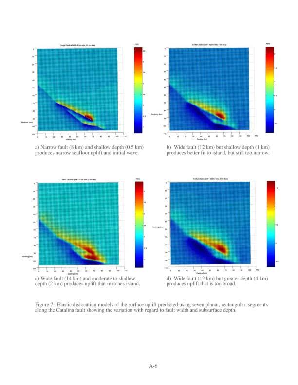
6

7
8 12 1 Pt. Dume Marina del Rey 8 King Harbor 6 Palos Verdes LA/LB Harbor Anaheim Bay 4 Avalon San Onofre 2 Wave Gauge Locations Figure 9. Map showing the extent of the bathymetry/topography grid where the MOST tsunami propagation calculations were performed. Wave gauge locations are plotted and wave gauge parameters are listed in Table 3. A-8
9 3. runup(m) A m m -.6 m m 2-1. m runup (m) Figure 1. Map showing initial wave height for the full seven segment Catalina fault model with graphs of run-up along the south-facing and west-facing shorelines
10 wave height (m) dume1 mdr1 kh1 1 2 time (min) wave height (m) pv1 lalb1 ana time (min) 4 5 wave height (m) sano1 ava time (min) Wave Gauge Records, Case 1 Figure 11. Wave gauge records for the full 7-segment Catalina fault (M=7.7) earthquake (Case 1). A-1

11 Palos Verdes Hills Santa Catalina Island LA Basin Figure 12. Time step in the MOST tsunami propagation simulation showing the two principal wave fronts generated from the northwest end and southeast end of the submerged Santa Catalina Island platform. Topography has large vertical exaggeration. A-11
12 Figure 13. Maps of the initial wave height conditions for the seven Catalina fault tsunami scenarios (Table 4).
13 runup (m) Case 1 Case 2 Case 3 Case 4 Case 5 Case 6 Case A Case 1 Case 2 Case 3 Case 4 Case 5 Case 6 Case runup (m) Figure 14. Map showing maximum run-up for each of the seven Catalina fault tsunamigenic earthquake scenarios modeled in this study (see Table 4 for fault parameters).
14 runup (normalized by max deformation) Case 1 : Case 2 : Case 3 : Case 4 : 1.33 Case 5 :.71 Case 6 : Case 7 :.461 A Case 1 : Case 2 : Case 3 : Case 4 : 1.33 Case 5 :.71 Case 6 : Case 7 : runup (normalized by max deformation) Figure 15. Plot showing maximum run-up for each of the seven Catalina fault tsunamigenic earthquake scenarios modeled in this study (see Table 4 for fault parameters).
15 EVALUATION OF TSUNAMI RISK FOR COASTAL SOUTHERN CALIFORNIA CITIES APPENDIX B Wave Gauges for Cases 2-7
SONGS SSC. Tom Freeman GeoPentech PRELIMINARY RESULTS
 SONGS SSC Tom Freeman GeoPentech PRELIMINARY RESULTS Focused Questions Summarize the tectonic setting What is the seismogenic thickness? Are you including deep ruptures in the upper mantle (~30 km)? Do
Mark Legg COASTAL DEFORMATION AND TECTONIC EVOLUTION OFFSHORE SAN ONOFRE
 COASTAL DEFORMATION AND TECTONIC EVOLUTION OFFSHORE SAN ONOFRE August 2013 Coastal Deformation and Tectonic Evolution Offshore San Onofre Mark R. Legg Legg Geophysical, Inc. The true sign of intelligence
John Shaw CRUSTAL DEFORMATION MODEL: OBLIQUE CONVERGENCE IN THE INNER CALIFORNIA BORDERLANDS ACCOMMODATED BY ACTIVE STRIKE-SLIP AND REVERSE FAULTS
 CRUSTAL DEFORMATION MODEL: OBLIQUE CONVERGENCE IN THE INNER CALIFORNIA BORDERLANDS ACCOMMODATED BY ACTIVE STRIKE-SLIP AND REVERSE FAULTS August 2013 SONGS SSC SSHAC Workshop # 2 (August 12-14, 2013) Crustal
CHAPTER 1 BASIC SEISMOLOGY AND EARTHQUAKE TERMINOLGY. Earth Formation Plate Tectonics Sources of Earthquakes...
 CHAPTER 1 BASIC SEISMOLOGY AND EARTHQUAKE TERMINOLGY Earth Formation... 1-2 Plate Tectonics... 1-2 Sources of Earthquakes... 1-3 Earth Faults... 1-4 Fault Creep... 1-5 California Faults... 1-6 Earthquake
Active Tectonics. Earthquakes, Uplift, and Landscape. Edward A. Keller University of California, Santa Barbara
 Prentice Hall Earth Science Series SUB Gottingen 214 80416X, im ^, 2002 A 7883 lllllllilwii Active Tectonics Earthquakes, Uplift, and Landscape Second Edition V Edward A. Keller University of California,
Earthquakes. Chapter Test A. Multiple Choice. Write the letter of the correct answer on the line at the left.
 Earthquakes Chapter Test A Multiple Choice Write the letter of the correct answer on the line at the left. 1. Stress that pushes a mass of rock in two opposite directions is called a. shearing. b. tension.
Basin & Range / Mojave Desert
 Basin & Range / Mojave Desert Basin & Range vs. Great Basin 1 2/20/2016 An overview of the last horst Basin and Range / Mojave Desert Summary: Granitic, volcanic, marine sedimentary, non marine sedimentary,
Inundation maps for the State of California. 1. Introduction. Richard K. Eisner 1, Jose C. Borrero 2, and Costas E. Synolakis 2. California, U.S.A.
 ITS 2001 Proceedings, NTHMP Review Session, Paper R-4 67 Inundation maps for the State of California Richard K. Eisner 1, Jose C. Borrero 2, and Costas E. Synolakis 2 1 Governor s Office of Emergency Services,
Deformation History of a Major Restraining Bend along a Right-Slip Fault: The San Clemente Fault Offshore Northern Baja California, Mexico
 Deformation History of a Major Restraining Bend along a Right-Slip Fault: The San Clemente Fault Offshore Northern Baja California, Mexico REPORT The main focus of this project was to investigate the deformation
Activity #3 - Bathymetric Mapping
 Activity #3 - Bathymetric Mapping Concepts # 1, 2 #1 The floor of the ocean is composed of hills, plains, ridges, trenches, and seamounts. #2 Oceanographers have developed methods for mapping the ocean
2.0 DATA COLLECTION AND LITERATURE REVIEW
 2.0 DATA COLLECTION AND LITERATURE REVIEW In order to perform the geotechnical evaluation, a comprehensive compilation and review of available publications, reports, and data was performed for all areas
MAR110 Lecture #5 Plate Tectonics-Earthquakes
 1 MAR110 Lecture #5 Plate Tectonics-Earthquakes Figure 5.0 Plate Formation & Subduction Destruction The formation of the ocean crust from magma that is upwelled into a pair of spreading centers. Pairs
APPENDIX IV.A Geotechnical Study
 City of Los Angeles February 2014 APPENDIX IV.A Geotechnical Study Technical Appendices Museum Square Office Building Draft Environmental Impact Report February 8, 2013 File No. 20477 5757 Wilshire, LLC
Geo736: Seismicity and California s Active Faults Introduction
 Geo736: Seismicity and California s Active Faults Course Notes: S. G. Wesnousky Spring 2018 Introduction California sits on the boundary of the Pacific - North American plate boundary (Figure 1). Relative
8.0 SUMMARY AND CONCLUSIONS
 8.0 SUMMARY AND CONCLUSIONS In November 2008, Pacific Gas and Electric (PG&E) informed the U.S. Nuclear Regulatory Commission (NRC) that preliminary results from the Diablo Canyon Power Plant (DCPP) Long
Earthquake Locations in the Inner Continental Borderland, Offshore Southern California
 Bulletin of the Seismological Society of America, 90, 2, pp. 425 449, April 2000 Earthquake Locations in the Inner Continental Borderland, Offshore Southern California by Luciana Astiz and Peter M. Shearer
68 Chapter 5 The Sea Floor Natural Formations
 68 Chapter 5 The Sea Floor Natural Formations require a separate book to be explained. However, the spherical depictions are particularly suited to show the largest formations of the ocean floor up to
3.1 GEOLOGY AND SOILS Introduction Definition of Resource
 3.1 GEOLOGY AND SOILS 3.1.1 Introduction 3.1.1.1 Definition of Resource The geologic resources of an area consist of all soil and bedrock materials. This includes sediments and rock outcroppings in the
Today: Basic regional framework. Western U.S. setting Eastern California Shear Zone (ECSZ) 1992 Landers EQ 1999 Hector Mine EQ Fault structure
 1992 Landers EQ 1999 Hector Mine EQ Fault structure") Today: Basic regional framework Western U.S. setting Eastern California Shear Zone (ECSZ) 1992 Landers EQ 1999 Hector Mine EQ Fault structure 1 2 Mojave and Southern Basin and Range - distribution of strike-slip
Today: Basic regional framework Western U.S. setting Eastern California Shear Zone (ECSZ) 1992 Landers EQ 1999 Hector Mine EQ Fault structure 1 2 Mojave and Southern Basin and Range - distribution of strike-slip
Simulations in the Los Angeles Basin
 83 Chapter 4 Simulations in the Los Angeles Basin This chapter reports the responses of steel moment-resisting frame (MRF) buildings to simulated earthquakes in the Los Angeles basin. I use broadband ground
Preliminary Study of Possible Tsunami Hazards in Taiwan Region
 Preliminary Study of Possible Tsunami Hazards in Taiwan Region Xiaoming Wang and Philip L.-F. Liu Cornell University (First Draft on May 25 2006) (Second Draft on June 1 2006) (Final Update on June 8 2006)
3.5.1 Environmental Setting
 This section describes geologic, seismic, and soil conditions in the proposed Project area and analyzes environmental impacts related to these issues that could result from the Project. The following discussion
BEM Model of slip on the Channel Islands Thrust, CA
 BEM Model of slip on the Channel Islands Thrust, CA Credit Where Credit is Due: Michele Cooke Michele Cooke UMass Amherst Has been training students/postdocs to work with and remesh the CFM since at least
Modeling of the 2011 Tohoku-oki. oki Tsunami and it s s impacts to Hawaii
 WAVES 11, KONA HAWAI`I Modeling of the 2011 Tohoku-oki oki Tsunami and it s s impacts to Hawaii Yoshiki Yamazaki 1, Volker Roeber 1, Kwok Fai Cheung 1 and Thorne Lay 2 1 Department of Ocean and Resources
MAR110 LECTURE #6 West Coast Earthquakes & Hot Spots
 17 September 2007 Lecture 6 West Coast Earthquakes & Hot Spots 1 MAR110 LECTURE #6 West Coast Earthquakes & Hot Spots Figure 6.1 Plate Formation & Subduction Destruction The formation of the ocean crust
Probabilistic Tsunami Hazard Analysis. Hong Kie Thio AECOM, Los Angeles
 Probabilistic Tsunami Hazard Analysis Hong Kie Thio AECOM, Los Angeles May 18, 2015 Overview Introduction Types of hazard analysis Similarities and differences to seismic hazard Methodology Elements o
Anomalous Seismicity in the San Diego Coastal Region Thomas H. Heaton U.S. Geological Survey 525 S. Wilson Ave. Pasadena, CA Abstract This
 Anomalous Seismicity in the San Diego Coastal Region Thomas H. Heaton U.S. Geological Survey 525 S. Wilson Ave. Pasadena, CA 91106 Abstract This short note documents recent seismic activity in the coastal
2. Tsunami Source Details
 2. Tsunami Source Details The Northland area faces a range of potential tsunamigenic sources that include several local and distant fault systems and underwater landslides. A NIWA study (Goff et al. 2006)
A. rift valley B. deep trench C. volcanic cone D. uplifted mountain. A. a volcanic island arc B. a large watershed area
 DC Practice Test Dynamic Crust PRCTICE TEST Zimm's Earth Science 2013 1. Which feature would most likely be forming at converging continental tectonic plate boundaries?. rift valley. deep trench C.
San Andreas and Other Fault Sources; Background Source
 1 San Andreas and Other Fault Sources; Background Source SSC TI Team Evaluation Steve Thompson Diablo Canyon SSHAC Level 3 PSHA Workshop #3 Feedback to Technical Integration Team on Preliminary Models
A) B) C) D) 4. Which diagram below best represents the pattern of magnetic orientation in the seafloor on the west (left) side of the ocean ridge?
 B) C) D) 4. Which diagram below best represents the pattern of magnetic orientation in the seafloor on the west (left) side of the ocean ridge?") 1. Crustal formation, which may cause the widening of an ocean, is most likely occurring at the boundary between the A) African Plate and the Eurasian Plate B) Pacific Plate and the Philippine Plate C)
1. Crustal formation, which may cause the widening of an ocean, is most likely occurring at the boundary between the A) African Plate and the Eurasian Plate B) Pacific Plate and the Philippine Plate C)
Earth s Tectonic Plates
 MASTER 49 6.2 3.7 5.4 Philippine Pacific 5.4 North American Juan de Fuca Caribbean Cocos 10.0 9.2 2.3 2.5 2.3 1.8 3.0 Indian-Australian 10.5 7.1 17.2 16.8 6.0 Nazca South American 11.1 10.3 7.3 3.7 7.5
Offshore Evidence for Uplift Rate Boundaries. Hans AbramsonWard Diablo Canyon SSHAC SSC Workshop 2 November 7, 2012
 Offshore Evidence for Uplift Rate Boundaries Hans AbramsonWard Diablo Canyon SSHAC SSC Workshop 2 November 7, 2012 Questions asked by the TI team Discuss your ability to distinguish and correlate offshore
Magnitude 7.7 QUEEN CHARLOTTE ISLANDS REGION
 A major 7.7 magnitude earthquake struck at 8:04 PM local time in western British Columbia, Canada. The epicenter is located on Moresby Island, the southern large island in the Queen Charlotte Islands region.
GPS Monitoring of the San Andreas Fault and Modeling of Slip Rate on the Mojave Section of the San Andreas Fault
 GPS Monitoring 1 GPS Monitoring of the San Andreas Fault and Modeling of Slip Rate on the Mojave Section of the San Andreas Fault By Nayeli Jimenez and Mischel Bartie PRISM Research Program Coordinator:
SONGS Seismic Research Projects
 SONGS Seismic Research Projects Energy Division Independent Peer Review Group September 21, 2012 Agenda Background Overview Project Support Permits, Approvals, and Reviews Schedule Use of Advanced Technologies
NAME HOMEWORK ASSIGNMENT #4 MATERIAL COVERS CHAPTERS 19, 20, 21, & 2
 NAME HOMEWORK ASSIGNMENT #4 MATERIAL COVERS CHAPTERS 19, 20, 21, & 2 Assignment is due the beginning of the class period on December 14, 2004. Mark answers on a scantron sheet, which will be provided.
SCEC Community Fault and Velocity Models and how they might contribute to the DCPP seismic hazard assessment. Andreas Plesch Harvard University
 SCEC Community Fault and Velocity Models and how they might contribute to the DCPP seismic hazard assessment Andreas Plesch Harvard University SCEC Unified Structural Representation (USR) The SCEC USR
NUMERICAL SIMULATIONS FOR TSUNAMI FORECASTING AT PADANG CITY USING OFFSHORE TSUNAMI SENSORS
 NUMERICAL SIMULATIONS FOR TSUNAMI FORECASTING AT PADANG CITY USING OFFSHORE TSUNAMI SENSORS Setyoajie Prayoedhie Supervisor: Yushiro FUJII MEE10518 Bunichiro SHIBAZAKI ABSTRACT We conducted numerical simulations
Topic 5: The Dynamic Crust (workbook p ) Evidence that Earth s crust has shifted and changed in both the past and the present is shown by:
 Evidence that Earth s crust has shifted and changed in both the past and the present is shown by:") Topic 5: The Dynamic Crust (workbook p. 65-85) Evidence that Earth s crust has shifted and changed in both the past and the present is shown by: --sedimentary horizontal rock layers (strata) are found
Topic 5: The Dynamic Crust (workbook p. 65-85) Evidence that Earth s crust has shifted and changed in both the past and the present is shown by: --sedimentary horizontal rock layers (strata) are found
IV. ENVIRONMENTAL IMPACT ANALYSIS E. GEOLOGY AND SOILS
 IV. ENVIRONMENTAL IMPACT ANALYSIS E. GEOLOGY AND SOILS INTRODUCTION This section evaluates potential impacts related to geology, including seismicity, and soils associated with development of the proposed
USU 1360 TECTONICS / PROCESSES
 USU 1360 TECTONICS / PROCESSES Observe the world map and each enlargement Pacific Northwest Tibet South America Japan 03.00.a1 South Atlantic Arabian Peninsula Observe features near the Pacific Northwest
1. Name at least one place that the mid-atlantic Ridge is exposed above sea level.
 Interpreting Tectonic and Bathymetric Maps. The purpose of this lab is to provide experience interpreting the bathymetry of the seafloor in terms of tectonic and geologic settings and processes. Use the
Appendix 6A Geologic Information about the Project Area prepared by Ninyo & Moore October 2008
 Appendix 6A Geologic Information about the Project Area prepared by Ninyo & Moore October 2008 Appendix 6A: Geologic Information about the Project Area 6A-1Existing Geologic and Subsurface Conditions
Evidence for a slab fragment wedged under Tokyo and its tectonic and seismic implications
 Supplementary Information to accompany Evidence for a slab fragment wedged under Tokyo and its tectonic and seismic implications Shinji Toda, Ross S. Stein, Stephen H. Kirby, and Serkan B. Bozkurt This
Tsunami waveform analyses of the 2006 underthrust and 2007 outer-rise Kurile earthquakes
 Author(s) 2008. This work is licensed under a Creative Commons License. Advances in Geosciences Tsunami waveform analyses of the 2006 underthrust and 2007 outer-rise Kurile earthquakes Y. Tanioka 1, Y.
Imaging sharp lateral velocity gradients using scattered waves on dense arrays: faults and basin edges
 2017 SCEC Proposal Report #17133 Imaging sharp lateral velocity gradients using scattered waves on dense arrays: faults and basin edges Principal Investigator Zhongwen Zhan Seismological Laboratory, California
3.3 GEOLOGY AND SOILS Environmental Setting Geologic Conditions
 3.3 GEOLOGY AND SOILS This section describes existing geologic and soil conditions, such as faults or unstable soils, and analyzes potential impacts that could pose hazards for the Fountain Valley Crossings
Model Uncertainties of the 2002 Update of California Seismic Hazard Maps
 Bulletin of the Seismological Society of America, Vol. 95, No. 6, pp. 24 257, December 25, doi: 1.1785/12517 Model Uncertainties of the 22 Update of California Seismic Hazard Maps by Tianqing Cao, Mark
Earthquake Tectonics and Hazards on the Continents June Recognizing and characterizing strike-slip faults and earthquakes in USA
 2464-4 Earthquake Tectonics and Hazards on the Continents 17-28 June 2013 Recognizing and characterizing strike-slip faults and earthquakes in USA S. G. Wesnousky Univ. of Nevada USA Strike-slip Faults
IV. Environmental Impact Analysis E. Geology and Soils
 IV. Environmental Impact Analysis E. Geology and Soils 1. Introduction This section of the Draft EIR provides an analysis of the Project s potential impacts with regard to geology and soils. The analysis
TSUNAMI PROPAGATION AND INUNDATION MODELINGS ALONG SOUTH-EAST COAST OF PAPUA NEW GUINEA
 TSUNAMI PROPAGATION AND INUNDATION MODELINGS ALONG SOUTH-EAST COAST OF PAPUA NEW GUINEA Martin WAREK Supervisor: Yushiro FUJII MEE12620 Bunichiro SHIBAZAKI ABSTRACT This study covers tsunami generation,
Dynamic Crust Practice
 1. Base your answer to the following question on the cross section below and on your knowledge of Earth science. The cross section represents the distance and age of ocean-floor bedrock found on both sides
2013 SCEC Annual Report
 2013 SCEC Annual Report Collaborative research: Documentation of Tsunami Deposits in the Carpinteria Estuary: A signal of Great Earthquakes on the Pitas Point Thrust L. Reynolds, A. Simms, T.K. Rockwell,
In this lab, we will study and analyze geologic maps from a few regions, including the Grand Canyon, western Wyoming, and coastal California.
 Name: Lab Section: work in groups, but each person turns in his/her own GEOSCIENCE 001 LAB UNDERSTANDING GEOLOGIC MAPS Geologic maps are colorful and even beautiful, but they also contain an amazing amount
Numerical investigation of the November 17, 2015 anomaly in the harbor of Crotone, Ionian Sea
 Numerical investigation of the November 17, 2015 anomaly in the harbor of Crotone, Ionian Sea F. Zaniboni, A. Armigliato, G. Pagnoni, M. A. Paparo, S. Tinti Dipartimento di Fisica e Astronomia, Alma Mater
Kinematics of the Southern California Fault System Constrained by GPS Measurements
 Title Page Kinematics of the Southern California Fault System Constrained by GPS Measurements Brendan Meade and Bradford Hager Three basic questions Large historical earthquakes One basic question How
Map shows 3 main features of ocean floor
 Map shows 3 main features of ocean floor 2017 Pearson Education, Inc. Chapter 3 Marine Provinces 2017 Pearson Education, Inc. 1 Chapter 3 Overview The study of bathymetry determines ocean depths and ocean
DCPP Seismic FAQ s Geosciences Department 08/04/2011 GM1) What magnitude earthquake is DCPP designed for?
 What magnitude earthquake is DCPP designed for?") GM1) What magnitude earthquake is DCPP designed for? The new design ground motions for DCPP were developed after the discovery of the Hosgri fault. In 1977, the largest magnitude of the Hosgri fault was
GM1) What magnitude earthquake is DCPP designed for? The new design ground motions for DCPP were developed after the discovery of the Hosgri fault. In 1977, the largest magnitude of the Hosgri fault was
UNDERSTANDING GEOLOGIC M APS
 Name: Lab Section: work in groups, but each person turns in his/her own GEOSCIENCE 001 L AB UNDERSTANDING GEOLOGIC M APS Geologic maps are colorful and even beautiful, but they also contain an amazing
Earthquakes Earth, 9th edition, Chapter 11 Key Concepts What is an earthquake? Earthquake focus and epicenter What is an earthquake?
 1 2 3 4 5 6 7 8 9 10 Earthquakes Earth, 9 th edition, Chapter 11 Key Concepts Earthquake basics. "" and locating earthquakes.. Destruction resulting from earthquakes. Predicting earthquakes. Earthquakes
Bathymetry Measures the vertical distance from the ocean surface to mountains, valleys, plains, and other sea floor features
 1 2 3 4 5 6 7 8 9 10 11 CHAPTER 3 Marine Provinces Chapter Overview The study of bathymetry determines ocean depths and ocean floor topography. Echo sounding and satellites are efficient bathymetric tools.
Plates & Boundaries The earth's continents are constantly moving due to the motions of the tectonic plates.
 Plates & Boundaries The earth's continents are constantly moving due to the motions of the tectonic plates. As you can see, some of the plates contain continents and others are mostly under the ocean.
IV. ENVIRONMENTAL IMPACT ANALYSIS G. GEOLOGY AND SOILS
 IV. ENVIRONMENTAL IMPACT ANALYSIS G. GEOLOGY AND SOILS The following section is a summary of the geotechnical report conducted for the proposed project. The Report of Geotechnical Investigation Proposed
Diablo Canyon SSHAC Level 3 Study
 1 Diablo Canyon SSHAC Level 3 Study Workshop 1 Summary of SSC Hazard Significant Issues and Data Needed William Lettis November 29 to December 1, 2011 PG&E DCPP SSHAC Study 2 Hosgri Hosgri Location Hosgri
Fault Models SSC TI Team Evaluation Hans AbramsonWard
 1 Fault Models SSC TI Team Evaluation Hans AbramsonWard PG&E DCPP SSHAC Study 2 Outline Constraints on location of active faults: Uplift of ranges Quaternary fault map Constraints on Depth of seismogenic
A century of oil-field operations and earthquakes in the greater Los Angeles Basin, southern California
 A century of oil-field operations and earthquakes in the greater Los Angeles Basin, southern California Egill Hauksson 1, Thomas Göbel 1, Jean-Paul Ampuero 1, and Elizabeth Cochran 2 Downloaded 06/03/15
Earthquakes and Earthquake Hazards Earth - Chapter 11 Stan Hatfield Southwestern Illinois College
 Earthquakes and Earthquake Hazards Earth - Chapter 11 Stan Hatfield Southwestern Illinois College What Is an Earthquake? An earthquake is the vibration of Earth, produced by the rapid release of energy.
Earthquakes Chapter 19
 Earthquakes Chapter 19 Does not contain complete lecture notes. What is an earthquake An earthquake is the vibration of Earth produced by the rapid release of energy Energy released radiates in all directions
IV. ENVIRONMENTAL IMPACT ANALYSIS E. GEOLOGY AND SOILS
 IV. ENVIRONMENTAL IMPACT ANALYSIS E. GEOLOGY AND SOILS The following section is a summary of the geotechnical report conducted for the Proposed Project. The Geotechnical Engineering Investigation (the
EPSS 15. Spring Introduction to Oceanography. Laboratory #1 Maps, Cross-sections, Vertical Exaggeration, Graphs, and Contour Skills 4/7/17
 EPSS 15 Spring 2017 Introduction to Oceanography Laboratory #1 Maps, Cross-sections, Vertical Exaggeration, Graphs, and Contour Skills MAPS Provide valuable interface to explore the geography of the world
Lab 9: Satellite Geodesy (35 points)
") Lab 9: Satellite Geodesy (35 points) Here you will work with GPS Time Series data to explore plate motion and deformation in California. This lab modifies an exercise found here: http://www.unavco.org:8080/cws/pbonucleus/draftresources/sanandreas/
Lab 9: Satellite Geodesy (35 points) Here you will work with GPS Time Series data to explore plate motion and deformation in California. This lab modifies an exercise found here: http://www.unavco.org:8080/cws/pbonucleus/draftresources/sanandreas/
Learning Objectives (LO) What we ll learn today:!
 What we ll learn today:!") Learning Objectives (LO) Lecture 13: Mountain Building Read: Chapter 10 Homework #11 due Tuesday 12pm What we ll learn today:! 1. Define the types of stress that are present in the crust! 2. Define the
Learning Objectives (LO) Lecture 13: Mountain Building Read: Chapter 10 Homework #11 due Tuesday 12pm What we ll learn today:! 1. Define the types of stress that are present in the crust! 2. Define the
Chapter Overview. Bathymetry. Measuring Bathymetry. Measuring Bathymetry
 CHAPTER 3 Marine Provinces Chapter Overview The study of bathymetry determines ocean depths and ocean floor topography. Echo sounding and satellites are efficient bathymetric tools. Most ocean floor features
RR#8 - Free Response
 Base your answers to questions 1 through 4 on the passage and the map below and on your knowledge of Earth science. The map indicates the epicenter (*) of a major earthquake that occurred at 38 N 142 E.
ENVIRONMENTAL IMPACT ANALYSIS C. GEOLOGY
 IV. ENVIRONMENTAL IMPACT ANALYSIS C. GEOLOGY This section summarizes the results of a geotechnical evaluation conducted for the proposed project by Jerry Kovacs and Associates, Inc. in August 1996. The
NUMERICAL SIMULATION AS GUIDANCE IN MAKING TSUNAMI HAZARD MAP FOR LABUAN ISLAND
 NUMERICAL SIMULATION AS GUIDANCE IN MAKING TSUNAMI HAZARD MAP FOR LABUAN ISLAND MOHD RIDZUAN bin Adam Supervisor: Fumihiko IMAMURA MEE09199 ABSTRACT At the northeast end of the South China Sea, tsunamis
Investigation 5: What happens when plates move sideways past each other?
 Tectonics Investigation 5: Teacher Guide Investigation 5: What happens when plates move sideways past each other? Plates move sideways past each other at transform boundaries. At these boundaries, the
Jack Loveless Department of Geosciences Smith College
 Geodetic constraints on fault interactions and stressing rates in southern California Jack Loveless Department of Geosciences Smith College jloveless@smith.edu Brendan Meade Department of Earth & Planetary
Definition: Plate tectonics: the theory that the earth s surface consists of a mosaic of internally rigid plates that move relative to each other
 Chapter 2 Plate tectonics Definition: Plate tectonics: the theory that the earth s surface consists of a mosaic of internally rigid plates that move relative to each other Plate boundaries: zones of faulting
Summer 2014 Reading the Geologic History of Doheny State Beach Rodger More LAYERS LET S TAKE A TOUR THE BLUFFS
 Summer 2014 Reading the Geologic History of Doheny State Beach Rodger More DSBIA Board Officer and Geologist (retired) LAYERS of sediment and rock are like a book. Formations make up chapters and individual
 http://www.neic.cr.usgs.gov/neis/pands/global.html Global Seismicity and World Cities This map displays the worldwide hazard to cities by large earthquakes. When earthquakes occur near cities, the potential
Heather Schlosser Army Corps of Engineers Coastal Studies Group August 28, 2008
 Got sand? Regional Sediment Management in Orange County Heather Schlosser Army Corps of Engineers Coastal Studies Group August 28, 2008 Regional Sediment Management Regional sediment management recognizes
Lessons from the 2004 Sumatra earthquake and the Asian tsunami
 Lessons from the 2004 Sumatra earthquake and the Asian tsunami Kenji Satake National Institute of Advanced Industrial Science and Technology Outline 1. The largest earthquake in the last 40 years 2. Tsunami
3.5 GEOLOGY Introduction Environmental Setting
 3.5 GEOLOGY 3. Affected Environment and Environmental Analysis 3.5 GEOLOGY 3.5.1 Introduction This section provides information about the geologic conditions of the project site and surrounding area, and
Elastic Rebound Theory
 Earthquakes Elastic Rebound Theory Earthquakes occur when strain exceeds the strength of the rock and the rock fractures. The arrival of earthquakes waves is recorded by a seismograph. The amplitude of
Tsunami potential and modeling
 Tsunami potential and modeling GEORGE PRIEST OREGON DEPT. OF GEOLOGY AND MINERAL INDUSTRIES NEWPORT COASTAL FIELD OFFICE April 7, 2012 GeoPRISMS Cascadia Workshop, Portland, Oregon What creates most uncertainty
RUPTURE MODELS AND GROUND MOTION FOR SHAKEOUT AND OTHER SOUTHERN SAN ANDREAS FAULT SCENARIOS
 RUPTURE MODELS AND GROUND MOTION FOR SHAKEOUT AND OTHER SOUTHERN SAN ANDREAS FAULT SCENARIOS ABSTRACT : L.A. Dalguer 1, S.M. Day 2, K. Olsen 3, and V.M. Cruz-Atienza 4 1 Institute of Geophysics, ETH-Zurich,
San Andreas Movie Can It Happen?
 San Andreas Movie Can It Happen? Learning Objectives (LO) Lecture 14: Faults and Quakes Read: Chapter 10 and 11 Homework #12 due Thursday 12pm What we ll learn today:! 1. Compare strike-slip to dip-slip
Table S1. Different scenarios of terrace ages and their resultant predicted MIS 5c and MIS 5a sea-level
 DR2015257 GSA Data Repository Table S1. Different scenarios of terrace ages and their resultant predicted MIS 5c and MIS 5a sea-level elevations at Santa Cruz, California. Figure S1. Predictions of GIA
FINAL EXAM Crustal Deformation CONVERGE DIVERGENT PLATES MANTLE PLUMES FLUX BASALTIC GRANITIC
 Crustal Deformation Reading: Chapter 10 Pages 283-304 Review Questions 4, 6, 7, 10, 12, 15, 18, 20 FINAL EXAM NOON TO 2 PM, TUESDAY DEC. 5 HERE: Natural Science 101 BRING A SCAN TRON TURN IN YOUR REVIEW
Elastic rebound theory
 Elastic rebound theory Focus epicenter - wave propagation Dip-Slip Fault - Normal Normal Fault vertical motion due to tensional stress Hanging wall moves down, relative to the footwall Opal Mountain, Mojave
GEOL/GEOE 344: EARTHQUAKES AND SEISMIC HAZARDS (FALL 2001) FINAL EXAM NAME: TIME AVAILABLE: 120 MINUTES TOTAL POINTS: 110
 FINAL EXAM NAME: TIME AVAILABLE: 120 MINUTES TOTAL POINTS: 110") GEOL/GEOE 344: EARTHQUAKES AND SEISMIC HAZARDS (FALL 2001) FINAL EXAM NAME: TIME AVAILABLE: 120 MINUTES TOTAL POINTS: 110 (yep, that s 10 bonus points, just for showing up!) Instructions: There are several
GEOL/GEOE 344: EARTHQUAKES AND SEISMIC HAZARDS (FALL 2001) FINAL EXAM NAME: TIME AVAILABLE: 120 MINUTES TOTAL POINTS: 110 (yep, that s 10 bonus points, just for showing up!) Instructions: There are several
Earthquakes in Ohio? Teacher Directions and Lesson
 Earthquakes in Ohio? Teacher Directions and Lesson If I say, earthquake what state do you think of? Answers will vary, but California is a likely answer. What if I asked you, Where could you live in the
Differentiating earthquake tsunamis from other sources; how do we tell the difference?
 Differentiating earthquake tsunamis from other sources; how do we tell the difference? David Tappin (1), Stephan Grilli (2), Jeffrey Harris (2), Timothy Masterlark (3), James Kirby (4), Fengyan Shi Shi
1. Label a few examples of lines of latitude and lines of longitude on the globe above left.
 Oceanography 2 Location, Direction, and Distance on Nautical Charts Please read Appendix III in the textbook for reference. Learning Objectives for the first nautical chart Lab 1. Use the latitude-longitude
Plate Tectonics - Demonstration
 Name: Reference: Prof. Larry Braile - Educational Resources Copyright 2000. L. Braile. Permission granted for reproduction for non-commercial uses. http://web.ics.purdue.edu/~braile/indexlinks/educ.htm
Surface Faulting and Deformation Assessment & Mitigation
 Surface Faulting and Deformation Assessment & Mitigation Summary of a Shlemon Specialty Conference sponsored by the Association of Environmental & Engineering Geologists convened on February 19 & 20, 2009
to: Interseismic strain accumulation and the earthquake potential on the southern San
 Supplementary material to: Interseismic strain accumulation and the earthquake potential on the southern San Andreas fault system by Yuri Fialko Methods The San Bernardino-Coachella Valley segment of the
3.5 GEOLOGY Introduction Environmental Setting
 3.5 GEOLOGY 3. Affected Environment and Environmental Analysis 3.5 GEOLOGY 3.5.1 Introduction This section provides information about the geologic conditions of the project site and surrounding area, and