Outcrop Analog Lower Paleozoic Hydrothermal Dolomite Reservoirs, Mohawk Valley, New York
|
|
|
- Charlene Bailey
- 5 years ago
- Views:
Transcription


1 Outcrop Analog Lower Paleozoic Hydrothermal Dolomite Reservoirs, Mohawk Valley, New York Fortuna Energy Inc. Richard Nyahay, Brian Slater, and Taury Smith New York State Museum
2 Introduction Trenton Black River hydrothermal dolomite reservoirs are complex and heterogeneous structural-stratigraphic-diagenetic plays A lot of the details are simply not resolvable with subsurface data Goal of this in-progress study is to use outcrop analog which can help better understand structural complexity, the links between faults, fractures, folds, rock types and diagenesis Will also provide excellent teaching opportunity for those interested in play
3 Outcrop Analog for Black River Structural Analog En echelon faults, folds, sags, scissor faults, strike-slip faulting Diagenetic Analog Dolomite only occurs around faults Saddle dolomite in vugs and fractures Paragenetic sequence similar (matrix dolomite/saddle dolomite/quartz/bitumen/calcite) Saddle dolomite-cemented breccias clearly fault-related (not karst) Geochemistry of dolomites is similar

4 Quarry 100 miles Black River Producing Area
5 Palatine Bridge Quarry (Fisher, 1980) Outcrop occurs near Mohawk River. Regional NE-SW trending normal faults with up to 500 feet of throw only affect Utica and older rocks.

6 Tribes Hill Formation is Lower Ordovician and is the upper part of the Beekmantown The Tribes Hill is mainly composed of limestone in the Mohawk Valley The underlying Little Falls is all dolomite and sandstone with little or no limestone
7 2004 Outcrop Analog Activity Partially uncovered dolomite structures Ran two 3D ground penetrating radar surveys Uncovered major structure in lower quarry delineated with 3D GPR Preliminary map of the structure Take initial aerial photographs Presented early results at AAPG Eastern Section meeting demonstrating value as an outcrop analog for TBR reservoirs


8 Partially uncovered structure Break Hurley and Budros, 1990 Proportions and break remarkably similar to Albion Scipio
 agreed that it looks like an")
9 Flipped image of Rochester 3D En echelon dolomitized bodies in quarry exposure very similar to en echelon bodies in Rochester 3D Talisman and East Resources Geologists (who have seen the most 3D seismic) agreed that it looks like an excellent analog

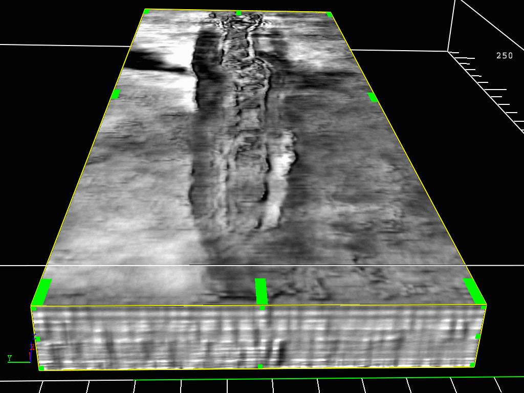
10 3-D Ground Penetrating Radar (GPR) Survey 30m 3D Survey Area 26 m 3D Survey processed in a few hours Shows incredible amount of detail Cheap and relatively easy Survey Conducted by Mark Grasmueck, University of Miami with help from Dave Viggianao and NYSM

11 Dolomite distribution reminiscent of CNR cartoon with massive dolomite around faults in middle of feature


12 Dolomitized interval is dimmed out Not all of sag is dolomitized

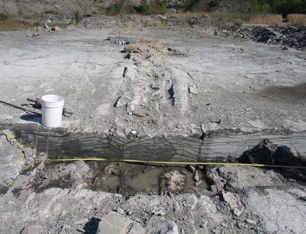
13 Most obvious open porosity is found in partially-cemented fractures on the northern flank of the structure and in vugs within the dolomite bodies like many TBR reservoirs


14 Vuggy porosity and saddle dolomite TBR Quarry Quarry


15 Dolomite-cemented breccia occurs at the tips of the structures, central portions of structures are dolomitized but mostly not brecciated
16 2005 Outcrop Analog Activity Six cores taken Enhanced 3D GPR Better aerial photograph and refined map Geochemistry Workshop Begin trenching of bottom structure Begin clearing off the top quarry


17 Limestone Coring Project Thanks to NYDOT Some permeability in cores especially at base of Tribes Hill in dolomite Dolomite Dolomite

18 Dolomite Dolomite Hole 4 in Break is dolomitized starting about 3 feet down after it crosses fault


19 6 Hole 6 cuts no obvious faults and is about 18 feet away from the dolomitized trend. The Tribes Hill is 90% limestone Limestones consist of mudstone, skeletal wackestone and skeletal packstone with abundant silty clay seams This type of rock is generally not ideal for hydrothermal alteration Hole ft Hole 43ft


20 All of the Tribes Hill is dolomitized below the second fault which is filled with coarse, porous saddle dolomite 2 Hole 2 was drilled inside outer fault zone into limestone at surface. The core cuts two faults. The upper 16 feet is limestone Hole 7ft Hole
 Fractures and")

21 1 inch (2.5cm) Fractures and vugs from TBR compose most of the porosity 1 inch (2.5cm)


22 1 Hole 9.5ftHole 23ft Hole 1 is cut by at one obvious fault. The Tribes Hill Formation is completely dolomitized. Chaotic bedding with small faults especially in upper 10 feet. Pyrite fills small fault in Lower Tribes Hill near contact with Little Falls


23 4 Hole 4 is cut by a 3ft. Hole 14 ft Tribes Hill Formation is limestone above the fault and dolomitized beneath the fault and the dolomite is heavily brecciated. This suggests that the two dolomite bodies are connected at depth


24 3 Hole 3 was drilled into the tip which is obviously brecciated on the surface. Breccia extends down for several feet. Tribes Hill totally dolomitized. Hole


25 5 Hole 5 Tribes Hill is completely dolomitized with common chaotic bedding in Hole 5 which is located in jog. The Tribes Hill dolomite is commonly brecciated and highly pyritized. Hole 14ft Hole
26


27 New Map and Enhanced Aerial Photographs

28 Geochemistry δ 18 O values for matrix dolomite and saddle dolomite are lighter than seawater dolomites would be.

29 Primary fluid inclusion homogenization temperatures range from with average around 125C. Salinities are a very high wt%.
30 This plot suggests that Tribes Hill and Black River samples formed from fluids that were about +2 per mil - much heavier than seawater in the Ordovician which was around 6 to 9 per mil.
31 Matrix and saddle dolomites are radiogenic compared to Lower Ordovician seawater which suggests interaction with underlying basement or feldspathic sandstones
32 Geochemistry All of these analyses suggest that the dolomite formed from a hot (125 C), saline (26 wt%) brine that passed through underlying basement or feldspathic sandstones prior to making the dolomite These values are very similar to those found in the Black River reservoirs

33 Core workshop and quarry fieldtrip June 7, 2005


34 Trenching Begins


35 Dolomite core of the structure stays wet longer than limestone


36 Fractures dip away from the dolomite body and are plugged with calcite on the south side

37 The dolomitized core is folded and has some open fractures the sag here is more of a syncline than a graben


38 Faults are partially cemented with dolomite, have porosity and have reverse sense of motion on near north side
39 Future Trench Sites We plan to trench key parts of structure including tips, jog, break and middle parts of features in order to better understand fault dip, type, and where dolomite and open fracture and vuggy porosity occur. We will use this data to build a 3D structural and diagenetic model
40 Working on structural analysis after trenching we may do sandbox modeling

41 Floor plans of characteristic domains Grasmueck et al. CSL2004
42

43


44 limestone Upper quarry before and after partial cleaning dolomite


45 Sag with beds dipping at 30 on both sides into structure Sliver of limestone preserved in middle of dolomite body Upper Quarry Structures

46 What if a vertical well was drilled right here in a TBR Field?

47 Dolomitized features in upper quarry run parallel to the feature in the lower quarry

48 Like lower quarry, there is porosity in vugs and fractures

49 It looks like there is also matrix porosity in some of the coarser rock types like this flat pebble conglomerate
50 After first pass, it looks like there are at least two dolomite bodies, but it is bigger and more complex than lower quarry planning to clean it, trench it and map it in detail dolomite limestone
51 Upper Quarry Lot of faulting, not all faults have associated dolomite (just like TBR play) Matrix, vuggy and fracture porosity Bigger than lower quarry exposure Will compare to lower quarry to see similarities Needs to be cleaned Plan to expand GPR survey and make detailed map and take aerial photos Also plan to cut trenches here
 The Tribes")

52 dolomite Tribes Hill Ocr =dolomite Ofw=limestone TH all limestone here (Fisher, 1980) The Tribes Hill is variably dolomitized in throughout the area- some dolomite bodies big enough to be reservoirs

53 Horizontal slickensides support strike-slip faulting in the area
54 Future Work Will continue to trench structures in the lower and upper quarry Will try to get shallow seismic refraction line that can image structures down to basement (probably about 400 ft) Will finish geochemistry and petrography on dolomites Will work to uncover other fault-controlled dolomites in the upper quarry Will expand 3D GPR coverage Will make a detailed map of known existing dolomite bodies in the quarry
55 Conclusions The quarry feature is a great analog for the Black River Play The upper quarry shows similar features that formed higher in the section suggesting similar process of formation. Porosity so far is limited to the northern flanks. More work and study need to be done This is just Chapter 2 more chapters to be written

56 Acknowledgements John Martin, NYSERDA Tom Mroz, NETL-DOE Fortuna Energy Gareth Cross, SUNY Buffalo Scott Meisener,, NYDOT Harold Brossman, Frey Estate Greg Piascik,, NYDOT Joe Santamaria,, NYDOT Rose Schulze, NYSM Jim Sandor,, NYSM Mark Grasmueck University of Miami Dave Viggianao University of Miami
Update on Trenton Black River Playbook Study-New York State Museum
 Update on Trenton Black River Playbook Study-New York State Museum Taury Smith, Rich Nyahay, Rick Bray, Courtney Lugert, Rose Schulze and Brian Slater New York State Museum Task 4: Geochemistry Task 1
Outcrop Analog. for. Lower Paleozoic Hydrothermal Dolomite Reservoirs, Mohawk Valley, NY. A thesis presented to the Faculty
 Outcrop Analog for Lower Paleozoic Hydrothermal Dolomite Reservoirs, Mohawk Valley, NY A thesis presented to the Faculty of the University at Albany, State University of New York in partial fulfillment
Update on Geochemistry and Diagenetic Models. Taury Smith, Richard Nyahay and Reservoir Characterization Group
 Update on Geochemistry and Diagenetic Models Taury Smith, Richard Nyahay and Reservoir Characterization Group Biggest Well Onshore US in 2004: One of [Fortuna s] New York wells (Reed #1) produced at more
The Sequence Stratigraphic and Paleogeograhic Distribution of Reservoir-Quality Dolomite, Madison Formation, Wyoming and Montana
 The Sequence Stratigraphic and Paleogeograhic Distribution of Reservoir-Quality Dolomite, Madison Formation, Wyoming and Montana TAURY SMITH AND GREGOR EBERLI The primary aim of this study is to show the
Western Kentucky CO 2 Storage Test
 Western Kentucky CO 2 Storage Test Principal Investigators: Rick Bowersox - Lexington Dave Williams - Henderson KGS First Friday Seminar Lexington, Kentucky March 4, 2011 The project proceeded in two phases:
Fusselman/Devonian Study. of the Midland Basin, Texas
 Fusselman/Devonian Study of the Midland Basin, Texas Fusselman-Devonian Study of the Midland Basin, Texas Overview The Fusselman-Devonian study of the Midland Basin is designed to enhance both exploration
Calcite Cements in Middle Devonian Dunedin Formation:
 Geochemistry of the Fracture-Filling Dolomite and Calcite Cements in Middle Devonian Dunedin Formation: Implication for the Strata Dolomitization Model Sze-Shan Yip 1, Hairuo Qing 1 and Osman Salad Hersi
=%REPORT RECONNAISSANCE OF CHISHOLM LAKE PROSPECT. October 25, 1977
 =%REPORT ON FIELD RECONNAISSANCE OF CHISHOLM LAKE PROSPECT October 25, 1977 Bruce D. Vincent Imperial Oil Limited, Minerals - Coal, CALGARY, ALBERTA CHISHOLM LAKE PROSPECT Introduction The Chisholm Lake
Structural Deformation and Karst in the Devonian Waterways Formation: Examples from Outcrops along the Athabasca River*
 Structural Deformation and Karst in the Devonian Waterways Formation: Examples from Outcrops along the Athabasca River* Chris L. Schneider 1 and Matthias Grobe 2 Search and Discovery Article #51073 (2015)
Characterizing Seal Bypass Systems at the Rock Springs Uplift, Southwest Wyoming, Using Seismic Attribute Analysis*
 Characterizing Seal Bypass Systems at the Rock Springs Uplift, Southwest Wyoming, Using Seismic Attribute Analysis* Yuri Ganshin 1 and Fred McLaughlin 1 Search and Discovery Article #80483 (2015)** Posted
PRECAMBRIAN CRYSTALLINE AQUIFER (METAMORPHIC ROCKS)
") HAYWARD QUADRANGLE: Groundwater Production by Aquifer In the 56-square-mile area of the Hayward Quadrangle, groundwater is produced from metamorphic crystalline rocks of the Precambrian basement (in the
HAYWARD QUADRANGLE: Groundwater Production by Aquifer In the 56-square-mile area of the Hayward Quadrangle, groundwater is produced from metamorphic crystalline rocks of the Precambrian basement (in the
Hydrothermal Dolomitization of Fluid Reservoirs in the Michigan Basin, USA* By David A. Barnes 1, Thomas M. Parris 2, and G.
 Hydrothermal Dolomitization of Fluid Reservoirs in the Michigan Basin, USA* By David A. Barnes 1, Thomas M. Parris 2, and G. Michael Grammer 1 Search and Discovery Article #50087 (2008) Posted July 10,
Hydrothermal Systems as Analogs for Breached hdtraps and Subsurface Healing: Outcrop and Subsurface Examples and Escape Mechanisms
 Hydrothermal Systems as Analogs for Breached hdtraps and Subsurface Healing: Outcrop and Subsurface Examples and Escape Mechanisms David Bowen, David Lageson, Lee Spangler (Montana State University) Bryan
Relationships of the Ordovician. Appalachian Basin. June 21, 2011
 Regional Stratigraphic and Facies Relationships of the Ordovician Utica/Point i t Pleasant Interval in the Appalachian Basin June 21, 2011 Ron Riley and Mark Baranoski Stratigraphic Correlation Chart Modified
!'f \, w. Alan Stewart Colorado Exploration Company, Golden STRUCTURE OF THE FOOTHILLS AREA WEST OF DENVER, COLORADO. Introduction
 STRUCTURE OF THE FOOTHLLS AREA WEST OF DENVER, COLORADO w. Alan Stewart Colorado Exploration Company, Golden ntroduction i ; The dominant structural features west of Denver and along the mountain front
Trenton-Black River (TBR) hydrothermal dolomite (HTD) reservoir model
 hydrothermal dolomite (HTD) reservoir model") The Ontario phase of the Trenton-Black River (TBR) hydrothermal dolomite (HTD) play: Historical context and contributions to a modern exploration model Terry Carter, Ministry of Natural Resources, London,
The Ontario phase of the Trenton-Black River (TBR) hydrothermal dolomite (HTD) play: Historical context and contributions to a modern exploration model Terry Carter, Ministry of Natural Resources, London,
AAPG HEDBERG RESEARCH CONFERENCE
 AAPG HEDBERG RESEARCH CONFERENCE Reservoir Scale Deformation - Characterization and Prediction June 22-28, 1997, Bryce, Utah Stratigraphic Controls on Fracture Distribution in the Austin Chalk: An Example
Geologic influence on variations in oil and gas production from the Cardium Formation, Ferrier Oilfield, west-central Alberta, Canada
 Geologic influence on variations in oil and gas production from the Cardium Formation, Ferrier Oilfield, west-central Alberta, Canada Marco Venieri and Per Kent Pedersen Department of Geoscience, University
High-resolution Sequence Stratigraphy of the Glauconitic Sandstone, Upper Mannville C Pool, Cessford Field: a Record of Evolving Accommodation
 Page No. 069-1 High-resolution Sequence Stratigraphy of the Glauconitic Sandstone, Upper Mannville C Pool, Cessford Field: a Record of Evolving Accommodation Thérèse Lynch* and John Hopkins, Department
 1-6 Figure 1.3. View of the field area, looking south-southwest. Left side of the picture shows the steep flank of the Green Mountain massif. The Vermont Valley and the Tinmouth Valley are separated by
Geology Stratigraphic Correlations (Lab #4, Winter 2010)
") Name: Answers Reg. lab day: Tu W Th Geology 1023 Stratigraphic Correlations (Lab #4, Winter 2010) Introduction Stratigraphic correlation is the process of comparing rocks at one locality with related rocks
Name: Answers Reg. lab day: Tu W Th Geology 1023 Stratigraphic Correlations (Lab #4, Winter 2010) Introduction Stratigraphic correlation is the process of comparing rocks at one locality with related rocks
Sediment and sedimentary rocks Sediment
 Sediment and sedimentary rocks Sediment From sediments to sedimentary rocks (transportation, deposition, preservation and lithification) Types of sedimentary rocks (clastic, chemical and organic) Sedimentary
Kentucky Geological Survey Marvin Blan #1 Hancock County, Kentucky Geologic Review. J. Richard Bowersox David A. Williams Kentucky Geological Survey
 Kentucky Geological Survey Marvin Blan #1 Hancock County, Kentucky Geologic Review J. Richard Bowersox David A. Williams Kentucky Geological Survey KYCCS Western Kentucky Project Review Lexington, Kentucky
Seismic Data and Drilling in Hancock Co., Kentucky February 21, 2008
 Seismic Data and Drilling in Hancock Co., Kentucky February 21, 2008 J.A. Drahovzal 2/21/08 1 Hancock County (H1) Information Provided at 2/7/08 Meeting Depth of Top (t) and Thickness (th) in feet t Kn
The geology of the Vermont Valley and the western flank of the Green Mountains between Dorset Mountain and Wallingford, Vermont
 University at Albany, State University of New York Scholars Archive Geology Theses and Dissertations Atmospheric and Environmental Sciences 1992 The geology of the Vermont Valley and the western flank
Geological Framework for Natural Gas Development in Central New York
 Geological Framework for Natural Gas Development in Central New York Natural Gas Development in Central New York Prepared by: Bruce Selleck Department of Geology Colgate University bselleck@mail.colgate.edu
Upper Ordovician reefs in the Hudson Bay Basin: Porosity evolution and hydrocarbon charge
 Upper Ordovician reefs in the Hudson Bay Basin: Porosity evolution and hydrocarbon charge Denis Lavoie 1, Ariane Castagner 2, Omid Haeri Ardakani 3, André Desrochers 2 1 Geological Survey of Canada, Québec
INTERVAL SHEET. VDMfl. Well No.: Well No. lloo. Tota 1 depth,_~5,-,0",0,- Oil Gas Water~Exploratory' From-To From-To From-To
 Page' l'- INTERVAL SHEET VDMfl. Well No.: Well No. lloo WWCR483 Date'_~7~/~2~2~/~64~ PitOP: Town of McGaheysville Well #2 Sydnor COUNTY: Ro ckingham (McGaheysville) VDMR Well No: W-1100 From-To From-To
Subsurface Geology and Resource Exploration
 LAB 11. Subsurface Geology and Resource Exploration Locating earth resources such as aluminum, copper, gold and gemstones has been an important job for geologists for a long time. This lab deals with the
WAMUNYU EDWARD MUREITHI I13/2358/2007
 WAMUNYU EDWARD MUREITHI I13/2358/2007 Olkaria geothermal area is situated south of Lake Naivasha on the floor of the southern segment of the Kenya rift. The geology of the Olkaria Geothermal area is subdivided
Lower Skinner Valley Fill Sandstones: Attractive Exploration Targets on the Northeast Oklahoma Platform*
 Lower Skinner Valley Fill Sandstones: Attractive Exploration Targets on the Northeast Oklahoma Platform* By Jim Puckette 1 Search and Discovery Article #10050 (2003) *Adapted from presentation to Tulsa
North Dakota Geological Survey
 Review of Hydrocarbon Production from the Stonewall and lower Interlake Formations: western North Dakota Williston Basin Timothy O. Nesheim North Dakota Geological Survey North Dakota Geological Survey
Characterization of Belloy, Kiskatinaw, and Debolt Water Disposal Zones in the Montney Play Area, NEBC
 Characterization of Belloy, Kiskatinaw, and Debolt Water Disposal Zones in the Montney Play Area, NEBC Brad J. Hayes Petrel Robertson Consulting Ltd. www.petrelrob.com Introduction Intensive development
Porosity partitioning in sedimentary cycles: implications for reservoir modeling
 Porosity partitioning in sedimentary cycles: implications for reservoir modeling Gregor P. Eberli 1), Langhorne B. Smith 2), Elena Morettini 3), Layaan Al-Kharusi 1) 1) Comparative Sedimentology Laboratory,
DEVONIAN OIL AND GAS PLAYS OF THE MICHIGAN BASIN
 DEVONIAN OIL AND GAS PLAYS OF THE MICHIGAN BASIN William B. Harrison, III Michigan Geological Repository for Research and Education (MGRRE) Western Michigan University-Michigan Geological Survey 1 Devonian
Recap and Integrated Rock Mechanics and Natural Fracture Study in the Bakken Formation, Williston Basin
 Recap and Integrated Rock Mechanics and Natural Fracture Study in the Bakken Formation, Williston Basin EERC, 2011 Cosima Theloy PhD Candidate Department of Geology and Geological Engineering Colorado
MAPPING BEDROCK: Verifying Depth to Bedrock in Calumet County using Seismic Refraction
 MAPPING BEDROCK: Verifying Depth to Bedrock in Calumet County using Seismic Refraction Revised December 13, 2011 Dave Hart Wisconsin Geological and Natural History Survey INTRODUCTION Seismic refraction
Structural and Petrophysical Characterization of Mixed Drain/Barrier Fault Zones in Carbonates: Example from the Castellas Fault (SE France)*
*") Structural and Petrophysical Characterization of Mixed Drain/Barrier Fault Zones in Carbonates: Example from the Castellas Fault (SE France)* Christophe Matonti 1, Juliette Lamarche 1, Yves Guglielmi 1,
Structural and Petrophysical Characterization of Mixed Drain/Barrier Fault Zones in Carbonates: Example from the Castellas Fault (SE France)* Christophe Matonti 1, Juliette Lamarche 1, Yves Guglielmi 1,
Ooids, Example #1 Pennsylvania, Union Furnace outcrop Black River Formation
 UNon-skeletal grains UOoids Ooids, Example #1 This oolitic grainstone occurs in the Black River Formation of Pennsylvania. The ooids in this thin section have not been extensively micritized and the original
11/22/2010. Groundwater in Unconsolidated Deposits. Alluvial (fluvial) deposits. - consist of gravel, sand, silt and clay
 deposits. - consist of gravel, sand, silt and clay") Groundwater in Unconsolidated Deposits Alluvial (fluvial) deposits - consist of gravel, sand, silt and clay - laid down by physical processes in rivers and flood plains - major sources for water supplies
Groundwater in Unconsolidated Deposits Alluvial (fluvial) deposits - consist of gravel, sand, silt and clay - laid down by physical processes in rivers and flood plains - major sources for water supplies
Fracture, Fluid Flow and Diagenetic History of the Arbuckle Group
 Fracture, Fluid Flow and Diagenetic History of the Arbuckle Group Robert H. Goldstein, Evan K. Franseen, W. Lynn Watney, Bradley King STATUS: Focused-term near completion, year 3 of 3 TIMING: Began August
Burrow-Mottled Carbonates in the Devonian Wabamun Formation, Pine Creek Gas Field, Alberta, Canada
 Page No. 142-1 Burrow-Mottled Carbonates in the Devonian Wabamun Formation, Pine Creek Gas Field, Alberta, Canada Gladys Fong Department of Earth and Atmospheric Sciences University of Alberta, Edmonton,
Ladyfern, N.E.B.C.: Major Gas Discovery in the Devonian Slave Point Formation
 Page No. 112-1 Ladyfern, N.E.B.C.: Major Gas Discovery in the Devonian Slave Point Formation Thomas Boreen and Kelvin Colquhoun, Apache Canada Ltd., Calgary, Alberta ABSTRACT The Upper Devonian Slave Point
Minnelusa Play: The impact of tectonics and an ancient dune field on production
 Minnelusa Play: The impact of tectonics and an ancient dune field on production Steven G. Fryberger ENHANCED OIL RECOVERY INSTITUTE Permian Tectonic Map of Wyoming 200 miles after Inden, et al, 1996 PermoPennsylvanian
By: Jared T. Freiburg Illinois State Geological Survey 5/17/ cm
 Current Research on the Mt. Simon Geology; Refining the Lower Mt. Simon Depositional Interpretation By: Jared T. Freiburg Illinois State Geological Survey freiburg@illinois.edu 5/17/2016 2.5 cm Collaborators
PROCEEDINGS, INDONESIAN PETROLEUM ASSOCIATION Thirty-Ninth Annual Convention and Exhibition, May 2015
 IPA15-SG-089 PROCEEDINGS, INDONESIAN PETROLEUM ASSOCIATION Thirty-Ninth Annual Convention and Exhibition, May 2015 STRUCTURAL INTERPRETATION OF TECTONICALLY ASSOCIATED NORMAL AND REVERSE FAULTS OF BUKIT
EAS 233 Geologic Structures and Maps Winter Miscellaneous practice map exercises. 1. Fault and separation:
 Miscellaneous practice map exercises 1. Fault and separation: With respect to Map 1, what are (a) the orientation of the fault, and (b) the orientation of bedding in the units cut by the fault. (c) Mark
11301 Reservoir Analogues Characterization by Means of GPR
 11301 Reservoir Analogues Characterization by Means of GPR E. Forte* (University of Trieste) & M. Pipan (University of Trieste) SUMMARY The study of hydrocarbon reservoir analogues is increasing important
Reservoir Characteristics of the Birdbear Formation in West- Central Saskatchewan
 Reservoir Characteristics of the Birdbear Formation in West- Central Saskatchewan Chao Yang Petroleum Geology Branch Exploration and Geological Services Division Saskatchewan Ministry of Energy and Resources
Geologic Considerations of Shallow SAGD Caprock; Seal Capacity, Seal Geometry and Seal Integrity, Athabasca Oilsands, Alberta Canada
 Geologic Considerations of Shallow SAGD Caprock; Seal Capacity, Seal Geometry and Seal Integrity, Athabasca Oilsands, Alberta Canada Gordon T. Stabb, Michael Webb Durando Resources Corp, Suncor Energy
Core Analysis and Correlation to Seismic Attributes, Weyburn Midale Pool, Southeastern Saskatchewan
 Core Analysis and Correlation to Seismic Attributes, Weyburn Midale Pool, Southeastern Saskatchewan Nicole M. Pendrigh 1 Pendrigh, N.M. (2004): Core analysis and correlation to seismic attributes, Weyburn
Fault/Fracture Related Dolomitisation of the Eocene Thebes Formation, Hammam Fauran Fault Block, Gulf of Suez*
 Fault/Fracture Related Dolomitisation of the Eocene Thebes Formation, Hammam Fauran Fault Block, Gulf of Suez* Cathy Hollis 1, Hilary Corlett 2, Jesal Hirani 2, David Hodgetts 2, Robert L. Gawthorpe 3,
Detailed Sedimentology and Inorganic Geochemistry of the Dolgeville Formation and Utica Group of the Central Mohawk Valley, NY
 Detailed Sedimentology and Inorganic Geochemistry of the Dolgeville Formation and Utica Group of the Central Mohawk Valley, NY Daniel Miserendino Jeffrey T. Pietras Introduction and Purpose Drill cores
Cattaraugus Creek: A Story of Flowing Water and the Geology of the Channel It Flows Through Presentation to West Valley Citizen Task Force 4/27/16
 Cattaraugus Creek: A Story of Flowing Water and the Geology of the Channel It Flows Through Presentation to West Valley Citizen Task Force 4/27/16 Raymond C. Vaughan, Ph.D. What happens if you drop a
Summary. Introduction. Observations and Interpretations
 Lower McMurray Formation sinkholes and their fill fabrics: effects of salt dissolution collapse-subsidence across the northern Athabasca oil sands deposit Paul L. Broughton, Chevron Canada Resources, Calgary,
Exploration Significance of Unconformity Structure on Subtle Pools. 1 Vertical structure characteristics of unconformity
 Exploration Significance of Unconformity Structure on Subtle Pools Wu Kongyou (China University of Petroleum,College of Geo-Resources and Information,Shandong Qingdao 266555) Abstract: Vertical structure
2003 GCSSEPM Foundation Ed Picou Fellowship Grant for Graduate Studies in the Earth Sciences Recipient
 2003 GCSSEPM Foundation Ed Picou Fellowship Grant for Graduate Studies in the Earth Sciences Recipient Tarek A. El Shayeb University of Texas at Austin Integrated reservoir characterization and 3-D diagenetic
Structural Geology Lab. The Objectives are to gain experience
 Geology 2 Structural Geology Lab The Objectives are to gain experience 1. Drawing cross sections from information given on geologic maps. 2. Recognizing folds and naming their parts on stereoscopic air
R ENW Services - Geophysics & GIS
 Yankton Block 1 Vermillion Block 2 N 2 0 1 Block 3 Elk Point 2 3 4 5 6 MILES Block 4 R20-2002-01 0 1 2 3 4 5 6 7 8 9 10 KILOMETERS Block 5 Figure courtesy of ENW Services - Geophysics & GIS Block 6 Test
TEMPERATURE GEOTHERMAL SYSTEM *.BY. Roger F. Harrison Salt Lake City, Utah. C; K. Blair
 - * f c * -6 9 -.I. lcal '. DEVELOPMENT AND TESTSNG OF A SMALL MODERATE TEMPERATURE GEOTHERMAL SYSTEM *.BY Roger F. Harrison Terra Tek, Inc. Salt Lake City, Utah C; K. Blair Terra Tek, Inc. - Salt Lake
THE HETEROGENEOUS STRUCTURE OF FAULT ZONES WITHIN CARBONATE ROCKS: EVIDENCE FROM OUTCROP STUDIES AND IMPLICATIONS FOR FLUID FLOW
 THE HETEROGENEOUS STRUCTURE OF FAULT ZONES WITHIN CARBONATE ROCKS: EVIDENCE FROM OUTCROP STUDIES AND IMPLICATIONS FOR FLUID FLOW C.G. Bonson*, J.J. Walsh, C. Childs, M.P.J. Schöpfer & V. Carboni Fault
5. Crater Rim Uplift and Crater Wall Collapse
 5. Crater Rim Uplift and Crater Wall Collapse The basic processes involved in crater rim uplift are understood, but there is a lot of evidence at the crater that has not been fully explored and may eventually
in Madison County, New York Natural Gas Development
 Natural Gas Development in Madison County, New York Bruce Selleck Department of Geology Colgate University Hamilton, NY 13346 bselleck@mail.colgate.edu Natural Gas Development in Madison County, New York
6. Crater Rim Uplift and Crater Wall Collapse
 6. Crater Rim Uplift and Crater Wall Collapse The basic processes involved in crater rim uplift are understood, but there is a lot of evidence at the crater that has not been fully explored and may eventually
NOA ASSESSMENT HARRIS QUARRY MENDOCINO COUNTY, CALIFORNIA TABLE OF CONTENTS
 NOA ASSESSMENT HARRIS QUARRY MENDOCINO COUNTY, CALIFORNIA TABLE OF CONTENTS Introduction... 1 Scope of Services... 1 Project Location and Description... 1 Geologic Setting... 1 Regional Geology... 1 Site
Continuity and Compartmentalization of Viking Formation gas production from the Ricinus / Bearberry area of the Rocky Mountain Triangle Zone
 Page No. 001-1 Continuity and Compartmentalization of Formation gas production from the Ricinus / Bearberry area of the Rocky Mountain Triangle Zone David Halwas* (Senior Staff Geologist), Darryl Parry
Shallow Karst Aquifer System of the Lake Belt Study Area, Miami-Dade County, Florida, USA EXTENDED ABSTRACT
 Second International Conference on Saltwater Intrusion and Coastal Aquifers Monitoring, Modeling, and Management. Merida, Mexico, March 30 April 2, 2003 Shallow Karst Aquifer System of the Lake Belt Study
Western Kentucky Deep Saline Reservoir CO 2 Storage Test. Principal Investigators: J. Richard Bowersox - Lexington David A. Williams - Henderson
 Western Kentucky Deep Saline Reservoir CO 2 Storage Test Principal Investigators: J. Richard Bowersox - Lexington David A. Williams - Henderson July 22, 2008 Electric power generating and industrial plants
East Gainsborough, Saskatchewan: a Prairie Evaporite salt dissolution and Mississippian erosional unconformity trap
 East Gainsborough, Saskatchewan: a Prairie Evaporite salt dissolution and Mississippian erosional unconformity trap Andre St.Onge* and Eric Strachan Upton Resources Inc., 3900, 205-5 th Avenue S.W., Calgary,
Sequence Stratigraphy of the Upper Cretaceous Niobrara Formation, A Bench, Wattenberg Field, Denver Julesburg Basin, Colorado*
 Sequence Stratigraphy of the Upper Cretaceous Niobrara Formation, A Bench, Wattenberg Field, Denver Julesburg Basin, Colorado* Lisa E. Remington LaChance 1 and Mark C. Robinson 1 Search and Discovery Article
FINAL TECHNICAL REPORT PHASE II
 FINAL TECHNICAL REPORT PHASE II GEOTHERlV1AL RESOURCE EXPLORATION & DEFINITION SB Geo Inc. DE-FC04-00AL66975 September 18 2001 SLIM HOLE 24-33 Steamboat Springs Nevada Colin Goranson Geothermal Resource
A.M. TUESDAY, 12 May hours
 Candidate Name Centre Number 2 Candidate Number GCE AS/A level 1212/01 New AS GEOLOGY - GL2a Investigative Geology A.M. TUESDAY, 12 May 2009 1 1 2 hours For Examiner s Use Only ADDITIONAL MATERIALS In
Masila 1: Shallow shelf carbonate facies variability and secondary reservoir development - Saar Formation Masila block, Yemen
 Masila 1: Shallow shelf carbonate facies variability and secondary reservoir development - Saar Formation Masila block, Yemen Kent Wilkinson* Nexen Inc., Calgary, AB kent_wilkinson@nexeninc.com ABSTRACT
The Origin of Matrix and Fracture Mega- Porosity in a Carbonate Bitumen Reservoir, Grosmont Formation, Saleski, Alberta T 85 R 19W4M
 The Origin of Matrix and Fracture Mega- Porosity in a Carbonate Bitumen Reservoir, Grosmont Formation, Saleski, Alberta T 85 R 19W4M Kent Barrett, Dr John Hopkins, Ken Wilde and Marnie Connelly Oct 2/07
HIGH TEMPERATURE HYDROTHERMAL ALTERATION IN ACTIVE GEOTHERMAL SYSTEMS A CASE STUDY OF OLKARIA DOMES
 Proceedings, 6 th African Rift Geothermal Conference Addis Ababa, Ethiopia, 2 nd 4 th November 2016 HIGH TEMPERATURE HYDROTHERMAL ALTERATION IN ACTIVE GEOTHERMAL SYSTEMS A CASE STUDY OF OLKARIA DOMES James
Mg-isotope & REE compositions of the St. George Group carbonates (WNL): Implications for the origin of dolomites & limestones
: Implications for the origin of dolomites & limestones") Mg-isotope & REE compositions of the St. George Group carbonates (WNL): Implications for the origin of dolomites & limestones K. Azmy Azmy et al., 2013. Chemical Geology 365, 64 75. Post-doc fellows Blamey,
Mg-isotope & REE compositions of the St. George Group carbonates (WNL): Implications for the origin of dolomites & limestones K. Azmy Azmy et al., 2013. Chemical Geology 365, 64 75. Post-doc fellows Blamey,
TITLE: MULTIDISCIPLINARY IMAGING OF ROCK PROPERTIES IN CARBONATE RESERVOIRS FOR FLOW-UNIT TARGETING SEMI-ANNUAL TECHNICAL REPORT
 TITLE: MULTIDISCIPLINARY IMAGING OF ROCK PROPERTIES IN CARBONATE RESERVOIRS FOR FLOW-UNIT TARGETING SEMI-ANNUAL TECHNICAL REPORT Reporting Period: 5/16/02 11/15/02 Author: Stephen C. Ruppel January 2003
Constraining the thermal history of carbonate reservoirs
 Constraining the thermal history of carbonate reservoirs Kristin Bergmann Victor P. Starr Assistant Professor Department of Earth, Atmospheric and Planetary Sciences MIT Earth Resources Laboratory 217
UNIT 4 SEDIMENTARY ROCKS
 UNIT 4 SEDIMENTARY ROCKS WHAT ARE SEDIMENTS Sediments are loose Earth materials (unconsolidated materials) such as sand which are transported by the action of water, wind, glacial ice and gravity. These
The Kingfisher Field, Uganda - A Bird in the Hand! S R Curd, R Downie, P C Logan, P Holley Heritage Oil plc *
 A Bird in the Hand! EXTENDED ABSTRACT The Kingfisher Field, Uganda - A Bird in the Hand! Heritage Oil plc * The Kingfisher Field lies on Uganda s western border beneath Lake Albert, situated in the western
PINCONNING REDEVELOPMENT PROGRAM
 PINCONNING REDEVELOPMENT PROGRAM INTRODUCTION: The Pinconning Field (Dundee) is one of three narrow Rogers City dolomite fields in the Michigan Basin. With the then-currrent technology and geologic understanding
Natural Fracture Systems in Carbonate Reservoirs
 Natural Fracture Systems in Carbonate Reservoirs Jo Garland & Andy Horbury with contributions from Pete Gutteridge, Julie Dewit and Sarah Thompson Cambridge Carbonates Ltd Finding Petroleum: Understanding
The Welsh Borderland. Geologically recent surface deposits. The Welsh Borderland
 The Welsh Borderland This account provides a broad perspective of the geology of the Welsh Borderland region which comprises the southeast of Powys, southern Shropshire, northern Gwent, the western half
Name: Date: Use the following to answer question 2.
 Name: Date: 1. Which of the following statements regarding the scientific method is false? A) A hypothesis must be agreed upon by more than one scientist. B) A theory is a hypothesis that has withstood
R E F I N I N G T H E A R T O F M I N E R A L E X P L O R A T I O N
 Jupiter Project R E F I N I N G T H E A R T O F M I N E R A L E X P L O R A T I O N Overview A large Carlin-style Au system, at least 4.5 km long and 3.5 km wide, occurs in early Paleozoic limestones and
Follow this and additional works at: Part of the Geology Commons
 Western Michigan University ScholarWorks at WMU Michigan Geological Repository for Research and Education Geosciences 2016 Geology of Michigan William B. Harrison III Michigan Geological Repository for
Lecture Outline Wednesday - Friday February 14-16, 2018
 Lecture Outline Wednesday - Friday February 14-16, 2018 Quiz 2 scheduled for Friday Feb 23 (Interlude B, Chapters 6,7) Questions? Chapter 6 Pages of the Past: Sedimentary Rocks Key Points for today Be
Depositional Model and Distribution of Marginal Marine Sands in the Chase Group, Hugoton Gas Field, Southwest Kansas and Oklahoma Panhandle
 Depositional Model and Distribution of Marginal Marine Sands in the Chase Group, Hugoton Gas Field, Southwest Kansas and Oklahoma Panhandle Nathan D. Winters, Martin K. Dubois, and Timothy R. Carr Kansas
Dakota Sandstone. of the Moxa Arch and Surrounding Green River Basin
 Dakota Sandstone of the Moxa Arch and Surrounding Green River Basin Dakota Sandstones of the Green River Basin Overview The Dakota sandstones of the Moxa Arch and surrounding Green River Basin remain attractive
APPENDIX C GEOLOGICAL CHANCE OF SUCCESS RYDER SCOTT COMPANY PETROLEUM CONSULTANTS
 APPENDIX C GEOLOGICAL CHANCE OF SUCCESS Page 2 The Geological Chance of Success is intended to evaluate the probability that a functioning petroleum system is in place for each prospective reservoir. The
Quaternary clays alluvial sands of the Shepparton Formation overlie the basement rocks.
 NAGAMBIE GOLDFIELD Regional Geological Setting The Nagambie Project is located within the Melbourne Structural Zone of Victoria. The lithologies range in age from the Upper Silurian Broadford Formation
GEOTHERMAL POTENTIAL OF ST. KITTS AND NEVIS ISLANDS
 GEOTHERMAL POTENTIAL OF ST. KITTS AND NEVIS ISLANDS By Gerald W. Huttrer Geothermal Management Company, Inc. For the Eastern Caribbean Geothermal Energy Project ( Geo- Caraibes ; G-C ) Presented Using
Subduction Zone Conditions
 Summary Students investigate core samples obtained across a subduction zone off the east coast of Japan and compare the rock found in each drill hole. Learning Objectives Students will be able to: Use
Evaluation of Petrophysical Properties of an Oil Field and their effects on production after gas injection
 Evaluation of Petrophysical Properties of an Oil Field and their effects on production after gas injection Abdolla Esmaeili, National Iranian South Oil Company (NISOC), Iran E- mail: esmaily_ab@yahoo.com
Answers: Internal Processes and Structures (Isostasy)
") Answers: Internal Processes and Structures (Isostasy) 1. Analyse the adjustment of the crust to changes in loads associated with volcanism, mountain building, erosion, and glaciation by using the concept
Answers: Internal Processes and Structures (Isostasy) 1. Analyse the adjustment of the crust to changes in loads associated with volcanism, mountain building, erosion, and glaciation by using the concept
technical article Satinder Chopra 1*, Kurt J. Marfurt 2 and Ha T. Mai 2
 first break volume 27, October 2009 technical article Using automatically generated 3D rose diagrams for correlation of seismic fracture lineaments with similar lineaments from attributes and well log
Tim Carr - West Virginia University
 Tim Carr - West Virginia University Elements Source Rock Migration Route Reservoir Rock Seal Rock Trap Processes Generation Migration Accumulation Preservation 2 Reservoir Porous & Permeable Rock Suitable
Why is quartz one of the most weathering-resistant minerals?
 Why is it a poor idea to use limestone for tombstones in a wet hot area like the Amazon rainforest? A) Because limestone weathers at a very fast rate B) Because limestone weathers at a very low rate C)
Rock Physics of Shales and Source Rocks. Gary Mavko Professor of Geophysics Director, Stanford Rock Physics Project
 Rock Physics of Shales and Source Rocks Gary Mavko Professor of Geophysics Director, Stanford Rock Physics Project 1 First Question: What is Shale? Shale -- a rock composed of mud-sized particles, such
THE MARCELLUS SHALE GAS PLAY Geology, Development, and Water-Resource Impact Mitigation
 THE MARCELLUS SHALE GAS PLAY Geology, Development, and Water-Resource Impact Mitigation John H. Williams New York Water Science Center Troy, New York https://profile.usgs.gov/jhwillia/ Marcellus shale