PLANE AND ATTITUDE OF STRATA
|
|
|
- Jade Jenkins
- 5 years ago
- Views:
Transcription

1


2 Field Methods in Geology I PLANE AND ATTITUDE OF STRATA ผ ช วยศาสตราจารย ดร.ว ช ย จ ฑะโกส ทธ กานนท ภาคว ชาธรณ ว ทยา คณะว ทยาศาสตร จ ฬาลงกรณ มหาว ทยาล ย vichaic@yahoo.com


3 Outline Basic knowledge Definition Geological structures Attitude of Line and Plane Technical terms Attitude of plane Strike / Dip Dip angle / Dip direction TEST Attitude measurement Attitude notation Homework
4 BASIC KNOWLEDGE
5 DEFINITION altitude attitude


6

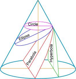
7 GEOLOGICAL STRUCTURES

8 Line & Plane?!?


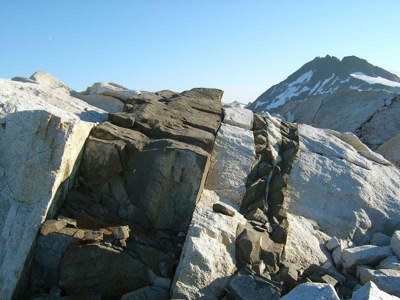
9 Geological structures from igneous processes


10 PLUTON Subjacent mass Batholith > 100 km 2 Stock < 100 km 2 Injected mass Dike / Dyke Sill Laccolith Lopolith VOLCANO Shield volcano Cinder cone volcano Stratovolcano / Composite volcano
11 dike

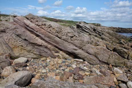
12 Geological structures from sedimentary processes

 Stratum")

13 STRATA stratum (plural=strata) Layer of rock characterized by particular lithologic properties and attributes that distinguish it from adjacent layers. International Commission on Stratigraphy (ICS) Stratum Many terms are used as follows: lamination/laminae laminae < 1 cm thick bed > 1 cm thick massive > 1 m thick thickness feature
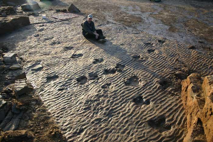

14 TRACK

15 Geological structures from metamorphic processes


16 FOLIATION Stress & Pressure horizontal slaty cleavage vertical slaty cleavage foliation
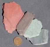


17 FOLIATION

18 Geological structures from deformation processes
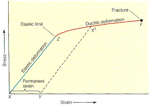


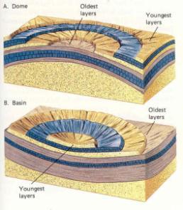

19 Force Ductile Fracture/Brittle DEFORMATION Elastic Ductile Fracture / Brittle Deformation Fold Monocline Anticline Syncline Dome Basin Fault Dip-slip fault Strike-slip fault Oblique-slip fault
20 fault
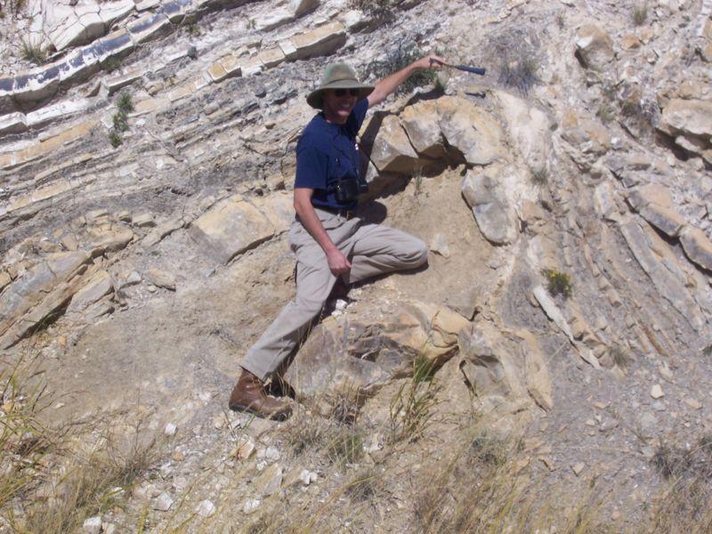
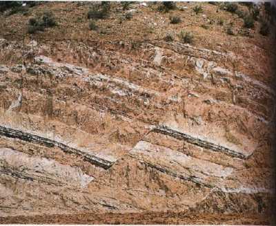
21 fold
22 ATTITUDE OF LINE AND PLANE

23 TECHNICAL TERMS Direction/Trend Inclination Trend Plunge Strike Dip Direction Dip Angle Azimuth & Quadrant/Bearing

24 DIRECTION / TREND azimuth bearing quadrant

25 azimuth bearing quadrant

26


27 Direction/Trend azimuth bearing quadrant

28 azimuth bearing quadrant

29

30 INCLINATION


31 Inclination inclination ม มเอ ยง (ดาราศาสตร ม มเงย ธรณ ว ทยาม มกด)
32 STRIKE & DIP

33 DIP ANGLE & DIP DIRECTION

34 Dip Direction Strike Dip Angle
35 Strike

36 Dip Direction

37 Dip Angle

38 ATTITUDE OF PLANE Direction/Trend Inclination Trend Plunge Strike Dip Direction Dip Angle Azimuth & Quadrant/Bearing ATTITUDE Strike/Dip DipAngle/DipDirection Trend/Plunge Strike Dip Angle Dip Direction
39 Strike / Dip Dip Direction Planar features such as fault plains, bedding surface, and joints can be oriented by measurement of the Downward inclination of the plane surface (dip) and the Direction or trend of the plane (strike). If we look at an outcrop of tilted beds in water, which gives us a level surface, it is easier to visualize dip and strike dip and strike. The angle between the bedding plane and the water surface is the dip and the trend of the waterline along the bedding plane is the strike. The true or maximum dip must be measured at right angles to the strike. These are measured in the field with a Brunton compass that was designed for this purpose.


40 Dip angle / Dip direction Dip Direction Dip Direction Strike Dip Angle


41 TEST


42


43

44
45 ATTITUDE MEASUREMENT SILVA BRUNTON
46 SILVA COMPASS True North Grid North Magnetic North


47 BRUNTON COMPASS True North Grid North Magnetic North Direction/Trend Inclination Attitude Strike/Dip Trend/Plunge


48 Strike

49 Dip Angle 37

50 Strike Dip Angle /37E or 337/37E More information
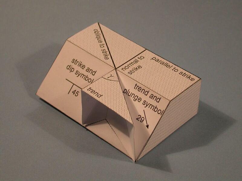
51 ATTITUDE NOTATION
 N65W, 25 S (\"Quadrant\"): the bearing of the strike direction is 65 degrees west of north and the dip is 25 degrees in a southerly direction.")
52 ATTITUDE NOTATION 1. Strike notation strike and dip angle (a) N65W, 25 S ("Quadrant"): the bearing of the strike direction is 65 degrees west of north and the dip is 25 degrees in a southerly direction. For a given strike, there are only two possible dip directions, one on each side of the strike line. Hence it is necessary only to identify which side by two letters. If the strike direction is nearly N-S or E-W, then a single letter is appropriate; if the strike direction is close to the 45 degree directions (NE or NW) then two letters are preferred. (b) 295, 25 S ("Azimuth"): the azimuth of the strike direction is 295 degrees measured clockwise from north and the dip is 25 degrees toward the south. Usually the trend of the northernmost end of the strike line is given, but the azimuth of the opposite end of the line may also be used, as in 115, 25 S. 2. Dip notation dip angle and dip direction (a) 25, S25W ("Quadrant"): the dip is 25 degrees and the trend of the dip direction has a bearing of 25 degrees west of south. (b) 25/205 ("Azimuth"): the dip is 25 degrees and the trend of the dip direction has an azimuth of 205 degrees measured clockwise from north. To avoid confusion, dip angles should always be given with two digits and the trend with three, even if this requires leading zeros. 3. ChulalongkornUniversity style ( DOS = Dip-Direction Over Strike) 115/25 S ("Azimuth"): the azimuth of the strike direction is 115 degrees measured clockwise from north and the dip is 25 degrees toward the south. Usually the trend of the strike line is given in ChulalongkornUniversity style (Dip-direction over strike) by using the strike trend following the trend of the dip direction, so the azimuth of the strike in this case must be 115, not 295.


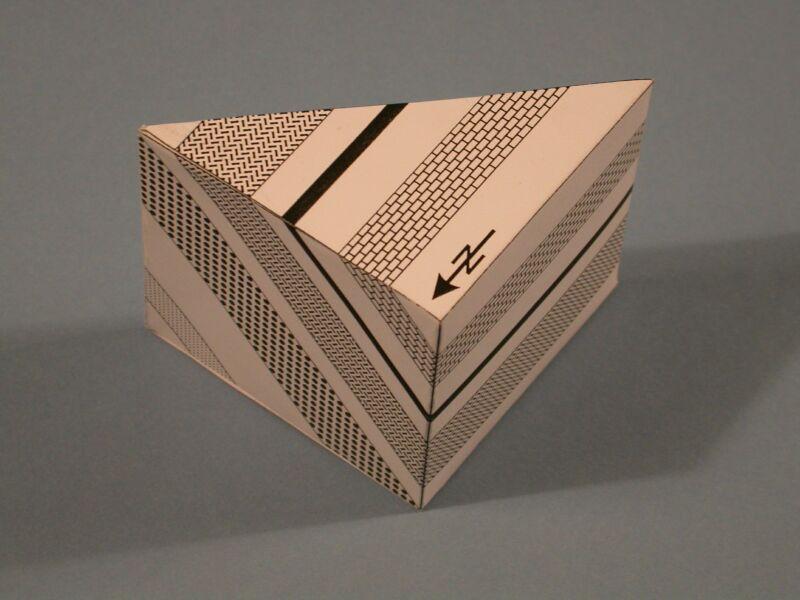
53 ATTITUDE NOTATION ON MAP MAP S CROSS SECTION
54 bearing quadrant azimuth
55 STRIKE AND DIP NOTATION 1. Strike notation strike, dip angle (a) N65W, 25 S ("Quadrant") (b) 295, 25 S ("Azimuth") 2. Dip notation dip angle, dip direction (a) 25, S25W ("Quadrant") (b) 25/205 ("Azimuth") 3. ChulalongkornUniversity Style 115/25 S ( DOS = Dip Over Strike ) N35W, 15 NE S35E, 15 NE 325, 15 NE 145, 15 NE 15, N55E CU-DOS 15/055 40/36 SE 325/15 NE
56 HOMEWORK
57 HOMEWORK STRIKE AND DIP NOTATION 1. Strike notation strike, dip angle (a) N65W, 25 S ("Quadrant") (b) 295, 25 S ("Azimuth") 2. Dip notation dip angle, dip direction (a) 25, S25W ("Quadrant") (b) 25/205 ("Azimuth") 3. ChulalongkornUniversity Style 115/25 S ( DOS = Dip Over Strike ) I am Noob!! CU-DOS
58 HOMEWORK STRIKE AND DIP NOTATION 1. Strike notation strike, dip angle (a) N65W, 25 S ("Quadrant") (b) 295, 25 S ("Azimuth") 2. Dip notation dip angle, dip direction (a) 25, S25W ("Quadrant") (b) 25/205 ("Azimuth") 3. ChulalongkornUniversity Style 115/25 S ( DOS = Dip Over Strike ) I am Pro!! CU-DOS
59 HOMEWORK STRIKE AND DIP NOTATION 1. Strike notation strike, dip angle (a) N65W, 25 S ("Quadrant") (b) 295, 25 S ("Azimuth") 2. Dip notation dip angle, dip direction (a) 25, S25W ("Quadrant") (b) 25/205 ("Azimuth") 3. ChulalongkornUniversity Style 115/25 S ( DOS = Dip Over Strike ) I am Inw!! CU-DOS
60 HOMEWORK STRIKE AND DIP NOTATION 1. Strike notation strike, dip angle (a) N65W, 25 S ("Quadrant") (b) 295, 25 S ("Azimuth") 2. Dip notation dip angle, dip direction (a) 25, S25W ("Quadrant") (b) 25/205 ("Azimuth") 3. ChulalongkornUniversity Style 115/25 S ( DOS = Dip Over Strike ) I am Marine!! ATTITUDE NOTATION Strike (a) N65W, 25 S S65E, 25 S Strike (b) 295, 25 S 115, 25 S Dip (a) 25, S25W Dip (b) 25/205 CU-DOS 115/25 S
61 HOMEWORK I am Geo!! STRIKE AND DIP NOTATION 1. Strike notation strike, dip angle (a) N65W, 25 S ("Quadrant") (b) 295, 25 S ("Azimuth") 2. Dip notation dip angle, dip direction (a) 25, S25W ("Quadrant") (b) 25/205 ("Azimuth") 3. ChulalongkornUniversity Style 115/25 S ( DOS = Dip Over Strike ) ATTITUDE NOTATION Strike (a) N65W, 25 S S65E, 25 S Strike (b) 295, 25 S 115, 25 S Dip (a) 25, S25W Dip (b) 25/205 CU-DOS 115/25 S
62 HOMEWORK STRIKE AND DIP NOTATION 1. Strike notation strike, dip angle (a) N65W, 25 S ("Quadrant") (b) 295, 25 S ("Azimuth") 2. Dip notation dip angle, dip direction (a) 25, S25W ("Quadrant") (b) 25/205 ("Azimuth") 3. ChulalongkornUniversity Style 115/25 S ( DOS = Dip Over Strike ) I am in Practice!! ATTITUDE 65 NOTATION 25 bedding plane vein fault joint other plane Strike (a) N65W, 25 S S65E, 25 S S35W, 15 S Strike (b) 295, 25 S 115, 25 S 080, 50 NW Dip (a) 25, S25W 80, N35E Dip (b) 25/205 45/295 CU-DOS 115/25 S 195/65 N
63 HOMEWORK STRIKE AND DIP NOTATION 1. Strike notation strike, dip angle (a) N65W, 25 S ("Quadrant") (b) 295, 25 S ("Azimuth") 2. Dip notation dip angle, dip direction (a) 25, S25W ("Quadrant") (b) 25/205 ("Azimuth") 3. ChulalongkornUniversity Style 115/25 S ( DOS = Dip Over Strike ) I am in Field!! ATTITUDE 65 NOTATION 25 bedding plane vein fault joint other plane Strike (a) N65W, 25 S S65E, 25 S Strike (b) 295, 25 S 115, 25 S Dip (a) 25, S25W Dip (b) 25/205 CU-DOS 115/25 S

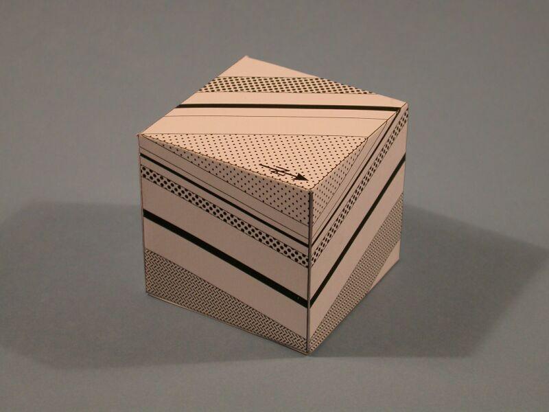
64 Paper models for geology mapwork Index * Strike and dip model * True and apparent dip model * Apparent dip model * 3 point problem * V-rule model * Unconformity model * Fault types * Faults displacing inclined beds * Normal faults and relay ramps * Cross-cutting normal faults * Plunging folds * Fault-propagation and fault-bend fold
65 HOMEWORK
66
67 HOMEWORK
68
69 HOMEWORK

70
71 THANK YOU
Stress and Strain. Stress is a force per unit area. Strain is a change in size or shape in response to stress
 Geologic Structures Geologic structures are dynamically-produced patterns or arrangements of rock or sediment that result from, and give information about, forces within the Earth Produced as rocks change
Structural Geology and Geology Maps Lab
 Structural Geology and Geology Maps Lab Mesa College Geology 101 Lab Ray Rector: Instructor Structural Geology Lab Pre-Lab Resources Pre-Lab Internet Links 1) Fundamentals of Structural Geology 2) Visualizing
Name. GEOL.5220 Structural Geology Faults, Folds, Outcrop Patterns and Geologic Maps. I. Properties of Earth Materials
 I. Properties of Earth Materials GEOL.5220 Structural Geology Faults, Folds, Outcrop Patterns and Geologic Maps Name When rocks are subjected to differential stress the resulting build-up in strain can
Chapter 15 Structures
 Chapter 15 Structures Plummer/McGeary/Carlson (c) The McGraw-Hill Companies, Inc. TECTONIC FORCES AT WORK Stress & Strain Stress Strain Compressive stress Shortening strain Tensional stress stretching
Part I. PRELAB SECTION To be completed before labs starts:
 Student Name: Physical Geology 101 Laboratory #13 Structural Geology II Drawing and Analyzing Folds and Faults Grade: Introduction & Purpose: Structural geology is the study of how geologic rock units
Lecture 6 Folds, Faults and Deformation Dr. Shwan Omar
 Fold: A fold is a bend or wrinkle of rock layers or foliation; folds form as a sequence of ductile deformation. Folding is the processes by which crustal forces deform an area of crust so that layers of
Crustal Deformation Earth - Chapter Pearson Education, Inc.
 Crustal Deformation Earth - Chapter 10 Structural Geology Structural geologists study the architecture and processes responsible for deformation of Earth s crust. A working knowledge of rock structures
Blocks Module Content Guide
 Blocks Module Content Guide This guide covers the basics of the content within the Interactive 3D Geologic Blocks Module. The content guide is intended to assist you, the teacher, in creating effective
What Causes Rock to Deform?
 Crustal Deformation Earth, Chapter 10 Chapter 10 Crustal Deformation What Causes Rock to Deform? Deformation is a general term that refers to all changes in the shape or position of a rock body in response
Crustal Deformation. (Building Earth s Surface, Part 1) Science 330 Summer Mapping geologic structures
 Science 330 Summer Mapping geologic structures") Crustal Deformation (Building Earth s Surface, Part 1) Science 330 Summer 2005 Mapping geologic structures When conducting a study of a region, a geologist identifies and describes the dominant rock structures
Crustal Deformation (Building Earth s Surface, Part 1) Science 330 Summer 2005 Mapping geologic structures When conducting a study of a region, a geologist identifies and describes the dominant rock structures
How mountains are made. We will talk about valleys (erosion and weathering later)
") How mountains are made We will talk about valleys (erosion and weathering later) http://www.ilike2learn.com/ilike2learn/mountainmaps/mountainranges.html Continent-continent plate convergence Less dense,
How mountains are made We will talk about valleys (erosion and weathering later) http://www.ilike2learn.com/ilike2learn/mountainmaps/mountainranges.html Continent-continent plate convergence Less dense,
Lab 7: STRUCTURAL GEOLOGY FOLDS AND FAULTS
 Lab 7: STRUCTURAL GEOLOGY FOLDS AND FAULTS This set of labs will focus on the structures that result from deformation in earth s crust, namely folds and faults. By the end of these labs you should be able
Study the architecture and processes responsible for deformation of Earth s crust. Folding and Faulting
 Crustal Deformation AKA Structural geology (adapted from Brunkel, 2012) Study the architecture and processes responsible for deformation of Earth s crust. Folding and Faulting How Rocks Deform: 4 Controls
How to Build a Mountain and other Geologic Structures. But first, questions
 How to Build a Mountain and other Geologic Structures But first, questions Questions your students might ask How were Montana s mountains formed? How old are the mountains? What are the different ways
Geologic Structures. Changes in the shape and/or orientation of rocks in response to applied stress
 Geologic Structures Changes in the shape and/or orientation of rocks in response to applied stress Figure 15.19 Can be as big as a breadbox Or much bigger than a breadbox Three basic types Fractures >>>
Answers: Internal Processes and Structures (Isostasy)
") Answers: Internal Processes and Structures (Isostasy) 1. Analyse the adjustment of the crust to changes in loads associated with volcanism, mountain building, erosion, and glaciation by using the concept
Answers: Internal Processes and Structures (Isostasy) 1. Analyse the adjustment of the crust to changes in loads associated with volcanism, mountain building, erosion, and glaciation by using the concept
Crustal Deformation. Earth Systems 3209
 Crustal Deformation Earth Systems 3209 Crustal Deformation pg. 415 Refers to all changes in the original form and/or size of a rock body. May also produce changes in the location and orientation of rocks.
Geomorphology Final Exam Study Guide
 Geomorphology Final Exam Study Guide Geologic Structures STRUCTURAL GEOLOGY concerned with shapes, arrangement, interrelationships of bedrock units & endogenic (within) forces that cause them. Tectonic
How to Build a Mountain and other Geologic Structures. But first a short review
 How to Build a Mountain and other Geologic Structures But first a short review Where do we see deep earthquakes? What is happening there? What can happen at a plate boundary? 1. Plates can move apart
Theme 7. Metamorphic rocks. Distinguishing rock types
 Theme 7. Metamorphic rocks. Distinguishing rock types 7.1. Metamorphic rocks formation 7.2. Classification of metamorphic rocks 7.3. Distinguishing rock types 7.1. Metamorphic rocks formation 7.1. Metamorphic
CRUSTAL DEFORMATION. Chapter 10
 CRUSTAL DEFORMATION and dgeologic Structures t Chapter 10 Deformation Df Deformation involves: Stress the amount of force applied to a given area. Types of Stress: Confining Stress stress applied equally
Provided by Tasa Graphic Arts, Inc. for An Introduction to Structural Methods DVD-ROM
 Provided by Tasa Graphic Arts, Inc. for An Introduction to Structural Methods DVD-ROM http://www.tasagraphicarts.com/progstruct.html AN INTRODUCTION TO STRUCTURAL METHODS - DETAILED CONTENTS: (Navigate
Lab 6: Plate tectonics, structural geology and geologic maps
 Geology 103 Name(s): Lab 6: Plate tectonics, structural geology and geologic maps Objective: To show the effects of plate tectonics on a large-scale set of rocks and to reconstruct the geological history
Deformation of Rocks. Orientation of Deformed Rocks
 Deformation of Rocks Folds and faults are geologic structures caused by deformation. Structural geology is the study of the deformation of rocks and its effects. Fig. 7.1 Orientation of Deformed Rocks
A. Refer to Appendix F in back of lab manual for list of commonly used geologic map symbols
 Structural Geology Lab 2: Outcrop Patterns and Structure Contours I. Geologic Map Symbols A. Refer to Appendix F in back of lab manual for list of commonly used geologic map symbols 1. Emphasis: a. strike
UNIVERSITY OF PRETORIA Department of Geology STRUCTURAL GEOLOGY -GLY 254 SEMESTER EXAM
 UNIVERSITY OF PRETORIA Department of Geology STRUCTURAL GEOLOGY -GLY 254 SEMESTER EXAM Copyright reserved 6 th June 2006 Time: 3 hours Internal examiner: Dr A.J. Bumby External examiner: Dr R. van der
UNIT 10 MOUNTAIN BUILDING AND EVOLUTION OF CONTINENTS
 UNIT 10 MOUNTAIN BUILDING AND EVOLUTION OF CONTINENTS ROCK DEFORMATION Tectonic forces exert different types of stress on rocks in different geologic environments. STRESS The first, called confining stress
Deformation: Modification of Rocks by Folding and Fracturing
 CHAPTER 7 Deformation: Modification of Rocks by Folding and Fracturing Chapter Summary A geologic map is a scientific model of rock formations that are exposed on the Earth s surface showing outcrops,
Chapter 16. Mountain Building. Mountain Building. Mountains and Plate Tectonics. what s the connection?
 Chapter 16 Mountains and Plate Tectonics what s the connection? Mountain Building Most crustal deformation occurs along plate margins. S.2 Active Margin Passive Margin Mountain Building Factors Affecting
KEY CHAPTER 12 TAKE-HOME QUIZ INTERNAL STRUCTURES AND PROCESSES Score Part B = / 55 PART B
 GEOLOGY 12 KEY CHAPTER 12 TAKE-HOME QUIZ INTERNAL STRUCTURES AND PROCESSES Score Part B = / 55 PART B CHAPTER 12 Isostacy and Structural Geology 1. Using the terms below, label the following diagrams and
11.1 Rock Deformation
 Tarbuck Lutgens Mountain Building 11.1 Rock Deformation Factors Affecting Deformation Factors that influence the strength of a rock and how it will deform include temperature, confining pressure, rock
Geotechnical & Structural Geology
 @IQ_UK Geotechnical & Structural Geology Institute of Quarrying Phil James BSc (Hons) MSc FCMI MIoD Julian Smallshaw FIQ, FHEA, BSc About The Institute 1917 Quarrying.org @IQ_UK Global extractives industry
Section 10.1 The Nature of Volcanic Eruptions This section discusses volcanic eruptions, types of volcanoes, and other volcanic landforms.
 Chapter 10 Section 10.1 The Nature of Volcanic Eruptions This section discusses volcanic eruptions, types of volcanoes, and other volcanic landforms. Reading Strategy Previewing Before you read the section,
GLY 155 Introduction to Physical Geology, W. Altermann. Press & Siever, compressive forces. Compressive forces cause folding and faulting.
 Press & Siever, 1995 compressive forces Compressive forces cause folding and faulting. faults 1 Uplift is followed by erosion, which creates new horizontal surface. lava flows Volcanic eruptions cover
Chapter 10: Volcanoes and Other Igneous Activity Section 1: The Nature of Volcanic Eruptions I. Factors Affecting Eruptions Group # Main Idea:
 Chapter 10: Volcanoes and Other Igneous Activity Section 1: The Nature of Volcanic Eruptions I. Factors Affecting Eruptions Group # A. Viscosity Group # B. Dissolved Gases Group # II. Volcanic Material
LAB 1: ORIENTATION OF LINES AND PLANES
 LAB 1: ORIENTATION OF LINES AND PLANES Read the introductory section, chapter 1, pages 1-3, of the manual by Rowland et al (2007) and make sure you understand the concepts of bearing, strike, dip, trend,
Stratigraphy. Stratigraphy deals with the study of any layered (stratified) rock, but primarily with sedimentary rocks and their
 rock, but primarily with sedimentary rocks and their") Stratigraphy Stratigraphy deals with the study of any layered (stratified) rock, but primarily with sedimentary rocks and their composition origin age relationships geographic extent Stratified Sedimentary
Stratigraphy Stratigraphy deals with the study of any layered (stratified) rock, but primarily with sedimentary rocks and their composition origin age relationships geographic extent Stratified Sedimentary
Chapter 10: Deformation and Mountain Building. Fig. 10.1
 Chapter 10: Deformation and Mountain Building Fig. 10.1 OBJECTIVES Describe the processes of rock deformation and compare and contrast ductile and brittle behavior in rocks. Explain how strike and dip
GEOL 110. Sedimentary Layering. Geologic Structures (faults, joints, folds), Unconformities, Karst. Sedimentary Layering 9/23/17. Geologic Structures
, Unconformities, Karst. Sedimentary Layering 9/23/17. Geologic Structures") GEOL 110 Sedimentary Layering Geologic Structures (faults, joints, folds), Unconformities, Karst Layering = horizontal, continuous banding produced during sediment deposition Sedimentary Layering Geologic
GEOL 110 Sedimentary Layering Geologic Structures (faults, joints, folds), Unconformities, Karst Layering = horizontal, continuous banding produced during sediment deposition Sedimentary Layering Geologic
GEOL 02: Historical Geology Lab 14: Topographic Maps. Name: Date:
 GEOL 02: Historical Geology Lab 14: Topographic Maps Name: Date: A topographic map is a two dimensional (flat) representation (model) of a three dimensional land surface (landscape). It shows landforms
You must take the exam in the lecture section for which you are registered. Any exceptions must be cleared with the instructor in advance.
 Geo 101, Fall 2000 Review Questions for Final Exam GEOLOGIC TIME AND FOLDING AND FAULTING THE FINAL EXAM FOR MWF CLASS WILL BE TUESDAY 1400 THE FINAL EXAM FOR TR CLASS WILL BE FRIDAY 930 These questions
Interactive 3D Sketchupbook
 THE UNIVERSITY OF SYDNEY - SCHOOL OF GEOSCIENCES Interactive 3D Sketchupbook Patrice F. Rey CHAPTER 1 Orienting Planes and Lines 1 Interactive 1.1 Strike, dip and dip direction In a 3D space, planar surfaces
Name: Date: Use the following to answer question 2.
 Name: Date: 1. Which of the following statements regarding the scientific method is false? A) A hypothesis must be agreed upon by more than one scientist. B) A theory is a hypothesis that has withstood
Structural Geology Lab. The Objectives are to gain experience
 Geology 2 Structural Geology Lab The Objectives are to gain experience 1. Drawing cross sections from information given on geologic maps. 2. Recognizing folds and naming their parts on stereoscopic air
Geological Mapping C Test
 Northern Regional: January 19 th, 2019 Geological Mapping C Test Name(s): Team Name: School Name: Team Number: Rank: Score: Remember to only write on the answer sheet. Points will be deducted if you write
N30 E-45 SE S25 E-10 SW N85 W-80 NE
 Geologic aps and tructures Name Geology 100 Harbor section Read h. 7 before you begin. The objectives of this lab are for you to learn the basic geologic structures in 3- and to develop some facility in
Primary Structures in Igneous Rocks. Engr. Sultan Ahmed Khoso
 Primary Structures in Igneous Rocks Engr. Sultan Ahmed Khoso Primary Structures in Igneous Rocks Primary Structures developed in the igneous rock during the time of cooling, crystallization and solidification
Lecture 9 faults, folds and mountain building
 Lecture 9 faults, folds and mountain building Rock deformation Deformation = all changes in size, shape, orientation, or position of a rock mass Structural geology is the study of rock deformation Deformation
sedimentary cover a) marine sediments b) continental sediments depth of crust: 5-10 km
 marine sediments b) continental sediments depth of crust: 5-10 km") Deformation and Brittle Fracture I. Primary Rock Structure A. Tectonic Control of Rock Structure 1. Lithospheric Plates a. plate = crust + upper mantle above asthenosphere (1) Layered Crust (a) oceanic
Deformation and Brittle Fracture I. Primary Rock Structure A. Tectonic Control of Rock Structure 1. Lithospheric Plates a. plate = crust + upper mantle above asthenosphere (1) Layered Crust (a) oceanic
Faults, folds and mountain building
 Faults, folds and mountain building Mountain belts Deformation Orogens (Oro = Greek all changes for mountain, in size, shape, genesis orientation, = Greek for or formation) position of a rock mass Structural
GY111 Earth Materials Practice Final Exam
 I. True/False Questions: circle a T for true or F for false (10% total -or- 0.5 per) 1. (T F) The Uranium used in nuclear power plants may explode if not controlled properly. 2. (T F) Natural Gas is an
Azimuth with RH rule. Quadrant. S 180 Quadrant Azimuth. Azimuth with RH rule N 45 W. Quadrant Azimuth
 30 45 30 45 Strike and dip notation (a) N30 E, 45 SE ("Quadrant"): the bearing of the strike direction is 30 degrees east of north and the dip is 45 degrees in a southeast (SE) direction. For a given strike,
Staple this part to part one of lab 6 and turn in. Lab 6, part two: Structural geology (analysis)
") Geology 101 Staple this part to part one of lab 6 and turn in Lab 6, part two: Structural geology (analysis) Recall that the objective of this lab is to describe the geologic structures of Cougar Mountain
Geology 101 Staple this part to part one of lab 6 and turn in Lab 6, part two: Structural geology (analysis) Recall that the objective of this lab is to describe the geologic structures of Cougar Mountain
Strike-Slip Faults. ! Fault motion is parallel to the strike of the fault.
 Strike-Slip Faults! Fault motion is parallel to the strike of the fault.! Usually vertical, no hanging-wall/footwall blocks.! Classified by the relative sense of motion. " Right lateral opposite block
Landforms and Rock Structure
 Landforms and Rock Structure Rock Structure as a Landform Control Landforms of Horizontal Strata and Coastal Plains Landforms of Warped Rock Layers Landforms Developed on Other Land-Mass Types Landforms
Preface and Overview. Folded strata in the mountains of Italy (ca AD), Leonardo da Vinci
, Leonardo da Vinci") Preface and Overview Folded strata in the mountains of Italy (ca. 1500 AD), Leonardo da Vinci Models of Mountain Building and Associated Deformation as represented by G.P. Scrope Deformation Feature: Scales
Preface and Overview Folded strata in the mountains of Italy (ca. 1500 AD), Leonardo da Vinci Models of Mountain Building and Associated Deformation as represented by G.P. Scrope Deformation Feature: Scales
1. classic definition = study of deformed rocks in the upper crust
 Structural Geology I. Introduction 1. classic definition = study of deformed rocks in the upper crust deformed includes translation, rotation, and strain (change of shape) All rocks are deformed in some
Answer sheet for question 1 Answer question 1 as soon as the sample arrives at your desk.
 EAS 233 Geologic structures. Final test. April 2012. 3 hours. Answer question 1 and 2 and three other questions. If you start more than the required number of questions, clearly delete the answers you
GEOLOGY 470 FIELD EXERCISE 3, SPRING SKETCHING, DESCRIBING, AND MAPPING EXPOSURES
 GEOLOGY 470 FIELD EXERCISE 3, SPRING 2009 -- SKETCHING, DESCRIBING, AND MAPPING EXPOSURES 1 OBJECTIVES: To develop and refine your field skills in: 1. observation and rock and sediment description 2. sketching
Springshed Springshed Management Training Curriculum
 Springshed Springshed Management Training Curriculum Management Training Curriculum Draft Version 2 January 2016 The Springs Initiative 2016 The Springs Initiative SESSION TITLE: Section Mapping SECTION:
Mountains are then built by deforming crust: Deformation & Mountain Building. Mountains form where stresses are high!
 Deformation & Mountain Building Where are mountains located? Deformation and Folding Mountain building Mountains form where stresses are high! Mountains form at all three types of plate boundaries where
Learning Objectives (LO) What we ll learn today:!
 What we ll learn today:!") Learning Objectives (LO) Lecture 13: Mountain Building Read: Chapter 10 Homework #11 due Tuesday 12pm What we ll learn today:! 1. Define the types of stress that are present in the crust! 2. Define the
Learning Objectives (LO) Lecture 13: Mountain Building Read: Chapter 10 Homework #11 due Tuesday 12pm What we ll learn today:! 1. Define the types of stress that are present in the crust! 2. Define the
A.M. TUESDAY, 12 May hours
 Candidate Name Centre Number 2 Candidate Number GCE AS/A level 1212/01 New AS GEOLOGY - GL2a Investigative Geology A.M. TUESDAY, 12 May 2009 1 1 2 hours For Examiner s Use Only ADDITIONAL MATERIALS In
NAME HOMEWORK ASSIGNMENT #3 MATERIAL COVERS CHAPTERS 8, 9, 10, 11
 NAME HOMEWORK ASSIGNMENT #3 MATERIAL OVERS HAPTERS 8, 9, 10, 11 Assignment is due the beginning of the class period on November 23, 2004. Answers for each chapter will be discussed in class, as Exam #3
Using An Introduction to Structural Methods - An Interactive CD-ROM - In and Out of the Classroom
 Using An to Structural Methods - An Interactive CD-ROM - In and Out of the Classroom Tekla A. Harms, Amherst College taharms@amherst.edu H. Robert Burger, Smith College rburger@email.smith.edu TYPE OF
Principles of Geology
 Principles of Geology Essential Questions What is Uniformitarianism? What is Catastrophism? What is Steno s s Law? What are the other geologic principles? How is relative age determined using these principles?
GCE AS/A level 1211/01 GEOLOGY GL1 Foundation Unit
 Surname Centre Number Candidate Number Other Names 2 GCE AS/A level 1211/01 GEOLOGY GL1 Foundation Unit S15-1211-01 A.M. MONDAY, 11 May 2015 1 hour For s use Question Maximum Mark 1. 15 2. 14 Mark Awarded
GEOLOGY 435 FIELD EXERCISE 2, SPRING SKETCHING, DESCRIBING, AND MAPPING EXPOSURES OBJECTIVES:
 OBJECTIVES: GEOLOGY 435 FIELD EXERCISE 2, SPRING 2016 -- SKETCHING, DESCRIBING, AND MAPPING EXPOSURES To develop and refine your field skills in: 1. observation and rock and sediment description 2. sketching
Chapter. Mountain Building
 Chapter Mountain Building 11.1 Rock Deformation Factors Affecting Deformation Factors that influence the strength of a rock and how it will deform include temperature, confining pressure, rock type, and
An aerial view from the south of the eruption of Mount St. Helens volcano on May 18, 1980.
 1 2 3 4 5 6 7 8 9 10 Building Earth s Surface Tillery, Chapter 21 Science 330 Summer 2007 An aerial view from the south of the eruption of Mount St. Helens volcano on May 18, 1980. Interpreting Earth s
Team Name. Name(s) SSSS Unome Geologic Mapping Test Packet p1
 SSSS Unome Geologic Mapping Test Packet p1") Scioly Summer Study Session 2018-2019 Geologic Mapping Test Packet Written by Unome Instructions 1) This test is based on the 2016 rules for Geologic Mapping. 2) This test is out of 115 points. Questions
Scioly Summer Study Session 2018-2019 Geologic Mapping Test Packet Written by Unome Instructions 1) This test is based on the 2016 rules for Geologic Mapping. 2) This test is out of 115 points. Questions
Chapter 7 Plate Tectonics
 Chapter 7 Plate Tectonics Earthquakes Earthquake = vibration of the Earth produced by the rapid release of energy. Seismic Waves Focus = the place within the Earth where the rock breaks, producing an earthquake.
GEO 303. Introduction to Geology LAB FINAL EXAM
 Name Lab section: Day Hour TA GEO 303 Introduction to Geology LAB FINAL EXAM Spring, 1999 100 points 2 INSTRUCTION: This multiple-choice, machine-graded exam consists of 100 questions, each worth 1 point.
Question 1: Examine the following diagram:
 Question 1: Examine the following diagram: 1a.) Which of the illustrated faults is a left-handed strike-slip fault? = a 1b.) Which of the illustrated faults is a normal-slip fault? = e 1c.) Which of the
Structural Geology Laboratory.
 Structural Geology Wikipedia-Structural geology is the study of the threedimensional distribution of rock units with respect to their deformational histories. The primary goal of structural geology is
NATIONAL EXAMINATIONS - December 2011
 04-88-14 Gedlogy (December 2011 ) Page 1 of 10 NATIONAL EXAMINATIONS - December 2011 04-BS~14Geology 3 hours duration NOTES: A. If doubt exists as to the interpretation of any question, the candidate is
Evaluation of Structural Geology of Jabal Omar
 International Journal of Engineering Research and Development e-issn: 2278-067X, p-issn: 2278-800X, www.ijerd.com Volume 11, Issue 01 (January 2015), PP.67-72 Dafalla Siddig Dafalla * and Ibrahim Abdel
Dip-Sequence Analysis
 Chapter 9 Dip-Sequence Analysis 9.1 Introduction The three-dimensional geometry of a structure can be determined from the bedding attitudes measured in a single well bore or on a traverse through a structure.
The University of Jordan. Accreditation & Quality Assurance Center. Course Name: Structural Geology COURSE Syllabus
 The University of Jordan Accreditation & Quality Assurance Center COURSE Syllabus Course Name: Structural Geology 0305341 1 Course title Structural Geology 2 Course number 0305341 3 Credit hours (theory,
TECTONIC AND STRUCTURAL CONTROLS ON INTRUSION- RELATED DEPOSITS IN THE NORTHERN PART OF SREDNA GORA ZONE, BULGARIA NIKOLAY PETROV & KAMELIA NEDKOVA
 TECTONIC AND STRUCTURAL CONTROLS ON INTRUSION- RELATED DEPOSITS IN THE NORTHERN PART OF SREDNA GORA ZONE, BULGARIA NIKOLAY PETROV & KAMELIA NEDKOVA INVESTIGATED AREA Praveshka Lakavica deposit Elatsite
UNDERSTANDING GEOLOGIC M APS
 Name: Lab Section: work in groups, but each person turns in his/her own GEOSCIENCE 001 L AB UNDERSTANDING GEOLOGIC M APS Geologic maps are colorful and even beautiful, but they also contain an amazing
Crags, Cracks, and Crumples: Crustal Deformation and Mountain Building
 Crags, Cracks, and Crumples: Crustal Deformation and Mountain Building Updated by: Rick Oches, Professor of Geology & Environmental Sciences Bentley University Waltham, Massachusetts Based on slides prepared
Strike & Dip. Structural Geology I: Folds & Faults 2009 Lect. 18, J. Steven Kite, West Virginia University
 2 Apr Structural Geology I: Folds & Faults 2009 Lect. 18, J. Steven Kite, West Virginia University Steeply dipping axial plane cleavage. These folded sedimentary layers exposed near Sullivan River in southeastern
Essentials of Geology, 11e
 Essentials of Geology, 11e Crustal Deformation and Mountain Building Chapter 17 Instructor Jennifer Barson Spokane Falls Community College Geology 101 Stanley Hatfield Southwestern Illinois College Jennifer
Introduction to Prospecting. Session Two Geology
 Introduction to Prospecting Session Two Geology The Earth Earth is 4.6 billion years old (Ba). Bacteria & algae +3.5 Ba. Microscopic animals ~2 Ba. Animals ~600 million years (Ma) old. Mankind about 100,000
Structural Geology, GEOL 330 Fold mapping lab: Even folds get parasites Spring, 2012
 Structural Geology, GEOL 330 Name: Fold mapping lab: Even folds get parasites Spring, 2012 This exercise is meant to mimic a field experience in which you, the student, will measure beddingcleavage relationships
Geology of Landscapes Chapter 6 (Building Earth s Surface Faulting and Folding)
") Geology of Landscapes Chapter 6 (Building Earth s Surface Faulting and Folding) Process of _ that the earth s Stress and Strain Any solid material responds to a force in a way that depends on: pressure
Geology of Landscapes Chapter 6 (Building Earth s Surface Faulting and Folding) Process of _ that the earth s Stress and Strain Any solid material responds to a force in a way that depends on: pressure
Location and Distance on Earth (Chapter 22 part 1)
") GEOLOGY 306 Laboratory Instructor: TERRY J. BOROUGHS NAME: Location and Distance on Earth (Chapter 22 part 1) For this assignment you will require: a calculator, protractor, and a metric ruler, and an
GEOLOGY 306 Laboratory Instructor: TERRY J. BOROUGHS NAME: Location and Distance on Earth (Chapter 22 part 1) For this assignment you will require: a calculator, protractor, and a metric ruler, and an
Lecture Outline Friday March 2 thru Wednesday March 7, 2018
 Lecture Outline Friday March 2 thru Wednesday March 7, 2018 Questions? Lecture Exam Friday March 9, 2018 Same time, Same room Bring Pencils and WSU ID 50 question Multiple Choice, Computer Graded Interlude
In this lab, we will study and analyze geologic maps from a few regions, including the Grand Canyon, western Wyoming, and coastal California.
 Name: Lab Section: work in groups, but each person turns in his/her own GEOSCIENCE 001 LAB UNDERSTANDING GEOLOGIC MAPS Geologic maps are colorful and even beautiful, but they also contain an amazing amount
CHAPTER 2. Structural Geology. Section I. Structural Features in Sedimentary Rocks FM 5-410
 CHAPTER 2 Structural Geology Structural geology describes the form, pattern, origin, and internal structure of rock and soil masses. Tectonics, a closely related field, deals with structural features on
GY111 Earth Materials Practice Final Exam
 I. True/False Questions: circle a T for true or F for false (10% total -or- 0.5 per) (Correct answer in red) 1. (T F) The Uranium used in nuclear power plants may explode if not controlled properly. 2.
Topics Laramide Orogeny: Late Cretaceous to Early Eocene Reading: GSA DNAG volume 3, Ch. 6
 Topics Laramide Orogeny: Late Cretaceous to Early Eocene Reading: GSA DNAG volume 3, Ch. 6 Late Cretaceous to early Eocene New patterns developed 5 main regions Tectonic interpretations Post-Laramide events
Relative Dating Exercises
 Laboratory 1 Relative Dating Exercises Pamela J. W. Gore Department of Geology, Georgia Perimeter College Clarkston, GA 30021 Copyright 1998-2005 Pamela J. W. Gore Examine the geologic cross sections which
Introduction to the Silva Ranger Compass. M. Helper, Jackson School of Geosciences, UT Austin
 Introduction to the Silva Ranger Compass Parts of the Silva Ranger Compass (Install Bull s Eye Level Here) Sighting Mirror Magnetic Needle with red North Sighting Notch Rotating Compass Card Clinometer
Structural Geology Lab. The Objectives are to gain experience
 Geology 2 Structural Geology Lab The Objectives are to gain experience 1. Drawing cross sections from information given on geologic maps. 2. Recognizing folds and naming their parts on stereoscopic air
Name Student ID Exam 2c GEOL 1113 Fall 2009
 Name Student ID Exam 2c GEOL 1113 Fall 2009 1. When a marine geologist collects a core of undeformed ocean-floor sediment, she knows that the youngest layer is on the top of the core and the oldest is
Earth Science - Lab #11 Geologic Time
 Earth Science - Lab #11 Geologic Time Page # Below are standard geologic symbols for the 3 main categories of rocks. Although these symbols are not universal, they are generally accepted by most geologists
TECHNICAL REPORT: REGIONAL GEOLOGY AND TECTONICS Resume. Huachon Project, Cerro de Pasco departments, Peru. By: AFC Logistic SAC
 TECHNICAL REPORT: REGIONAL GEOLOGY AND TECTONICS Resume Huachon Project, Cerro de Pasco departments, Peru By: AFC Logistic SAC December 2016 1. INTRODUCTION GPM Metals Peru, in its portfolio of generating
Comparison of Microseismic Results in Complex Geologies Reveals the Effect of Local Stresses on Fracture Propagation
 Comparison of Microseismic Results in Complex Geologies Reveals the Effect of Local Stresses on Fracture Propagation Mike Preiksaitis, Sheri Bowman, Ted Urbancic ESG Canada Inc. Summary Understanding the