Location and Distance on Earth (Chapter 22 part 1)
|
|
|
- Darleen Copeland
- 5 years ago
- Views:
Transcription
1 GEOLOGY 306 Laboratory Instructor: TERRY J. BOROUGHS NAME: Location and Distance on Earth (Chapter 22 part 1) For this assignment you will require: a calculator, protractor, and a metric ruler, and an atlas of maps (provided for you). Objectives: you should be able to explain the grid system used for locating places and features on Earth; use the Earth s grid system to accurately locate a place or feature; explain the relation between latitude and the angle of the North Star (Polaris) above the horizon; explain the relation between longitude and solar time; determine the shortest route and distance between any two places on Earth s surface. THE FOLLOWING QUESTIONS REFER Chapter 22 IN YOUR MANUAL (Read the questions from your manual and place your answers in the following spaces provided.) 1. Complete questions 1 through 7A on the diagrams in your manual, 7 th edition or questions 1 through 6 A, 8 th edition (activity 22.2). This will give you the needed practice to move on to question 7B, 7 th edition or 6B, 8 th edition. 7. Part B: Estimate the latitude of the various points associated with question 7B (7 th edition) or 6B (8 th edition). Point A: 30 N Latitude Point B: 5 S Latitude Point C: Point D: Point E: Point F: Use the index in the back of the Atlas of maps provided by your instructor to complete the following questions from your laboratory manual. 8. Identify the Latitude of the following locations: Zurich, Switzerland: Cairo, Egypt: Your home city, (identify and locate): 9. The farthest one can be from the equator is (45, 90, or 180) degrees of latitude. Select the best answer. 10. What are the names of the two places on Earth that are farthest from the equator to the north and the south? 11. What are the names of the five special parallels of latitude marked and named on most globes at the following locations? N Latitude: N Latitude: Latitude: S Latitude: S Latitude: 1
2 12. Is the angle of Polaris above the horizon from someone standing a point C, figure 22.3 (45, 90, or 180 degrees)? Select the best answer. 13. Is the relationship between the angle of Polaris and the angle of Latitude the same, i.e. the angles are the same? (Yes or No) 14. What is the degree to Polaris for the following locations? Anchorage, AK: degrees, minutes, etc. Calgary, Canada: degrees, minutes, etc. Orlando, Fl: degrees, minutes, etc. Your home city, (identify and locate): degrees, minutes, etc. 15. Identify the city that the prime meridian runs through in England! 16. How many degrees of longitude separate each of the meridians on most globes or maps? 17. Identify the Longitude for the following locations on Figure Point A: 30 E Longitude Point B: 20 W Longitude Point C: Point D: Point E: Point F: 18. Identify the Longitudes of the following locations: Melbourne, Australia: Honolulu, Hawaii: Your home city, (identify and locate): 19. The farthest a place can be directly east or west of the prime meridian is (45, 90 or 180 degrees). Select the best answer. 20. What is the Solar time for an observer located 1 degree East of the Noon Meridian? 21. What is the Solar time for an observer located 4 degrees West of the Noon Meridian? 2
3 22. If it is noon, according to Solar time (the Sun is directly above) at 70 W longitude, what is the solar time at each of the following locations? 65 W Longitude: 74 W Longitude 110 W Longitude: 90 E Longitude: 23. The following times represent Greenwich Mean Time or the time at the Prime Meridian in Greenwich, England. Using these times and the fact that the time at your ship s location is Noon (the Sun is directly above you), determine the Longitude of your ship relative to the Prime Meridian. Don t forget to include a direction (either East or West of the Prime Meridian!) Note: drawing a diagram showing the Prime Meridian, the ship s location east or west of the prime meridian, and the difference in hours may be helpful. 8:00 P.M.: 6:00 A.M.: 3:30 P.M.: 24. Using Figure 22.7 (7 th edition) or figure 22.6 (8 th edition) estimate the Latitude and Longitude of the following points. Point A: 30 N Latitude, 60 E Longitude Point B: Latitude, Longitude Point C: Latitude, Longitude Point D: Latitude, Longitude Point E: Latitude, Longitude 25. Identify the Latitude and Longitude of the following locations: Krakow, Poland: Latitude, Longitude Moscow, Russia: Latitude, Longitude Perth, Australia: Latitude, Longitude Lima, Peru: Latitude, Longitude 26. Identify the major (internationally-known) location (city, lake, mountain peak, etc.) based upon the Latitude and Longitude provided and any of the maps, globes, and atlases provided in the class room. If the location is a city, you should find an exact match for the latitude and longitude in your atlas. If the location is a geographical feature such as a lake or mountain range which covers a larger area, you may find an approximate match rather than an exact match in your atlas N Latitude, W Longitude: N Latitude, E Longitude: 3
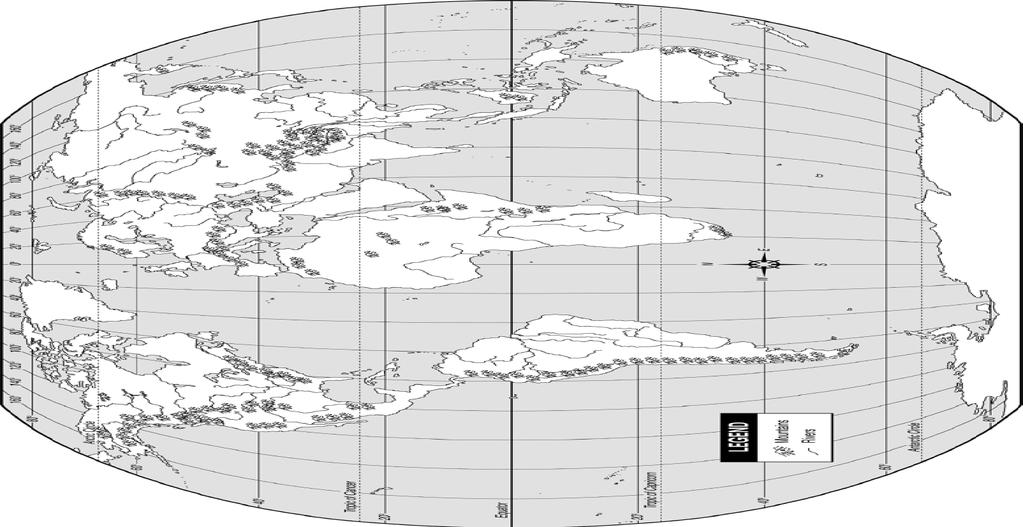
4 27. Extra credit! Use the following map to complete this question. Use a wall map of the world or world map in an atlas to find the following water bodies, rivers, and mountains. Examine their latitudes and longitudes, and then label each on the world map provided. To conserve space mark only the number or letter of the feature at the appropriate location on the map. The letter or number should be located and written directly on top of the appropriate feature, not off to the side of it!!! Water Bodies A. Pacific Ocean B. Atlantic Ocean C. Indian Ocean D. Arctic Ocean E. Gulf of Mexico F. Mediterranean Sea G. Caribbean Sea H. Persian Gulf I. Red Sea J. Sea of Japan K. Black Sea L. Caspian Sea Rivers North America a. Mississippi b. Colorado c. Missouri d. Ohio South America e. Amazon Europe and Asia f. Volga g. Mekong h. Ganges i. Yangtze Africa and Australia j. Nile k. Congo l. Darling Mountains North America 1. Rocky Mountains 2. Cascade Range 3. Sierra Nevada 4. Appalachian Mountains 5. Black hills 6. Teton Range 7. Adirondack Mountains South America 8. Andes Mountains Europe and Asia 9. Pyrenees Mountains 10. Alps 11. Himalaya Mountains 12. Ural Mountains Africa and Australia 13. Atlas mountains 14. MacDonnell Ranges 4
5 5
6 GEOLOGY 306 Laboratory Instructor: TERRY J. BOROUGHS NAME: Geologic Maps and Structures (Chapter 7) (7 th Edition) or (Chapter 8) (8 th edition) For this assignment you will require: metric ruler, protractor, colored pencils and eraser. Objectives: you should be able to explain how geologists describe the orientation of folded rocks and faults using the measurements strike and dip; draw and interpret a simple geologic block diagram; describe the various types of folds and how they form; recognize and diagram anticlines, synclines, domes and basins in both geologic map and cross-sectional views; discuss the formation and types of dip-slip and strike-slip faults; recognize and diagram the various types of faults in both geologic map and cross-sectional views; interpret a simplified geologic map and use it to construct a geologic cross section. TYPES OF STRESS: COMPRESSION TENSION SHEAR Directed pressure/stress toward each other, associated with converging plate margins. Directed pressure/stress away from each other, associated with diverging plate margins. Directed pressure/stress sliding past each other, associated with transform plate margins. TYPES OF STRAIN: ELASTIC: PLASTIC: OR DUCTILE: BRITTLE: Non-permanent deformation, once stress is released, the material returns to its original configuration. Permanent deformation, often ductile curved in appearance. Rigid deformation, where the material will rupture and break. STRIKE AND DIP: STRIKE: DIP: Describes the orientation of the strata relative to the compass directions (N, S, E, W) FOR EXAMPLE: STRIKE: N45 W Describes the amount and direction of tilting of the strata. FOR EXAMPLE: DIP: 45 N Describe the type of deformation you would expect if you dropped each of the items listed below onto a concrete floor. Elastic, Brittle, or Ductile Deformation Material Type of Deformation Tennis Ball Wine Glass Modeling Clay China Plate Pizza Dough 6


7 Fill in the blanks to formulate a series of handy-dandy rules to help in the interpretation of geologic maps and cross sections. a. The following rules refer to relative ages of sedimentary beds. Choose OLDER" OR YOUNGER" for your answers. When synclines and basin are eroded, the beds exposed in the center are than the beds exposed away from the center. When anticlines and domes are eroded, the beds exposed in the center are than the beds exposed away from the center. b. The following rules refer to beds and contacts between beds, as seen in map view. When folds have been eroded, the contacts between beds, as seen on a horizontal surface, are straight and parallel. Choose plunging or non - plunging. When plunging synclines have been eroded, the contacts between beds, as seen in map view (V-Shaped patterns), bend so as to point the direction of plunge. Choose toward or away from. When plunging anticlines have been eroded, the contacts between beds, as seen in map view (V-shaped patterns), bend so as to point the direction of plunge. Choose toward or away from. THE FOLLOWING PROBLEMS USE BLOCK DIAGRAMS REMEMBER STRIKE AND DIP READINGS INCLUDE BOTH AN ANGLE AND COMPASS DIRECTIONS! FOR EXAMPLE STRIKE: N45 W, DIP: 60 N For these 3D diagrams, just estimate the angles involved, e.g. 15, 30, 45, 60, and over 75. Block A 7
 Identify the dip for EACH of the fold limbs. Remember to include both the approximate dip angle and dip direction!")

8 BLOCK A. 1. Use the Strike and dip symbols to help you identify various features/aspects of this fold. 2. Is this a plunging fold? 3. Identify the strike (of the fold axis and limbs) Identify the dip for EACH of the fold limbs. Remember to include both the approximate dip angle and dip direction! For Example: 45 E and 45 W 4. Identify this fold BLOCK B and 1. Use the Strike and dip symbols to help you identify various features/aspects of this fold. 2. Is this a plunging fold? 3. Identify the strike (of the fold axis and limbs) Identify the dip for EACH of the fold limbs. Remember to include both the approximate dip angle and dip direction! For Example: 45 E and 45 W 4. Identify this fold and Block B Block C 8


9 BLOCK C 1. Use the Strike and dip symbols to help you identify various features/aspects of this fold. 2. Is this a plunging fold? 3. Identify the direction of plunge and the approximate amount of plunge of the fold axis. 4. Identify this fold BE SPECIFIC! BLOCK D 1. Draw the relative movement of the hanging wall and footwall ON THE FRONT (CROSS-SECTIONAL) VIEW using arrows. Identify the dip of the fault surface. Remember to include both the approximate dip angle and dip direction! For Example: 45 E 2. Is the hanging wall moving up or down? 3. Identify this fault. Block D Block E 9


10 BLOCK E 1. Draw the relative movement of the hanging wall and footwall ON THE FRONT (CROSS-SECTIONAL) VIEW using arrows. Identify the dip of the fault surface. Remember to include both the approximate dip angle and dip direction! For Example: 45 E 2. Is the hanging wall moving up or down? 3. Identify this fault. BLOCK F 1. Draw the relative movement of the hanging wall and footwall ON THE FRONT (CROSS-SECTIONAL) VIEW using arrows. Identify the dip of the fault surface. Remember to include both the approximate dip angle and dip direction! For Example: 45 E 2. Is the hanging wall moving up or down? 3. Identify this fault. BE SPECIFIC! -- Block F Block G 10
11 BLOCK G 1. Draw the relative movement of the fault on the MAP (surface) view using arrows. 2. What is the strike of the fault plane? 3. What is the relative motion on this fault? 4. Identify this fault. BE SPECIFIC! THE FOLLOWING QUESTIONS REFER TO Chapter 7 (7 th edition) or Chapter 8 (8 th Edition) IN YOUR MANUAL (Read the questions from your manual and place your answers in the following spaces provided.) 2. Place your answers here rather than on figure 7.5 (7 th edition) or figure 8.4 (8 th edition) of your manual. Left Map: Strike: North Angle of Dip: Direction of Dip: Right Map: Strike: North Angle of Dip: Direction of Dip: 3. Write your answers here regarding fold types in figure 8.12 (8 th edition): Identify the fold in each diagram: Left diagram: Right Diagram: Identify the ages of the rock layers in each of the diagrams: Anticline: Youngest: : Oldest Syncline: Youngest: : Oldest The plane extending through each block diagram is called: The rock layers for the anticline dip the axial plane. The rock layers for the syncline dip the axial plane. The Syncline is symmetrical or asymmetrical? The Anticline is symmetrical or asymmetrical? Are these folds plunging or non-plunging? Rocks exposed at the surface of the syncline get older or younger near the fold axis? Rocks exposed at the surface of the anticline get older or younger near the fold axis? 11
12 4. Using Figure 7.21 (7 th edition) or figure 8.16 (8 th edition), you should observe the blocks of rock on either side of the fault and indicate the relative ages of the surface rocks on either side of the fault trace. One side will be older and the other side will be younger. Keep in mind that the fault will dip toward the Hanging wall, which will also be above the fault surface. The block that is below the fault surface will be the Foot wall. Using this information complete the following questions. a. On an eroded normal fault, the rocks at the surface on the direction of the dip (side in which the fault is dipping and/or the Hanging wall side) are the (youngest or oldest) surface rocks? Pick one. b. On an eroded reverse fault, the rocks at the surface on the direction of the dip (side in which the fault is dipping and/or the Hanging wall side) are the (youngest or oldest) surface rocks? Pick one. 5. Is the fault illustrated in figure 7.23 or figure 8.19 (8 th edition) a (right-lateral or left-lateral) strikeslip fault? Pick one. The following questions refer to figure 7.25 (7 th edition) or figure 8.22 (8 th edition) a geologic map of the Devils Fence, Montana area. 6. What is the verbal and fractional scale of the Devils Fence map? You may have to convert your verbal scale to a fractional scale. Verbal Scale: 1 inch = Miles Fractional Scale: : 7. Identify the Oldest and youngest sedimentary rocks by the Name and geologic age or period (not numerical age) Youngest: Name: Geologic Age (name): Oldest: Name: Geologic Age (name): 8. Are the intrusive igneous rocks near the center of the structure in (younger or older) than the adjacent sedimentary rocks? Pick one. 9. Examine the strike and dip of the rock units on the Devils Fence Geologic map. Draw in several large arrows on the map, pointing in the direction of dip of several of the rock units. A) Do the rock layers indicated near the center of the map in section 14 dip toward the (northwest or southeast)? Pick one. B) The same rocks in section 14 are also found in section 18. Do the rocks in section 18 dip toward the (East or West)? Pick one A: B: 10. Are the rocks getting (older or younger) away from the center of the fold? Pick one. 12
13 11. Is this geologic structure a (non-plunging or plunging) (Anticline or Syncline)? Pick the best combination of answers. 12. List at least two lines of evidence that you used to determine the type of structure identified above. Evidence: Extra Credit Questions from Chapter 8 (Summary / Report Page): 1. Use figure 7.27 (7 th edition) or figure 8.23 (8 th edition) in your manual and provide the strike and dip of the igneous intrusion (7 th edition) or limestone layer (8 th edition). Strike: North Angle and direction of dip: 2. What type of stress, (compression or tension) was responsible for producing the geologic structure in figure 7.25 (7 th edition) or figure 8.22 or 8.23 (large geologic map with legend, 8 th edition)? Pick one. 3. Label the hanging wall and the footwall on each of the two faults illustrated in figure 7.29 (6 th edition) or figure 7.31 (7 th edition) or 8.27 (8 th edition). On each photo, draw arrows showing the relative movement of both sides of the fault. Determine if the hanging wall is going up or down for each photo. Name the type of fault illustrated in each photo and describe the forces or stresses that produced it. Is the hanging wall going up or down for figure A: Figure B: A. Name: Stress / Forces: B. Name: Stress / Forces: The End!! 13
Lab 7: STRUCTURAL GEOLOGY FOLDS AND FAULTS
 Lab 7: STRUCTURAL GEOLOGY FOLDS AND FAULTS This set of labs will focus on the structures that result from deformation in earth s crust, namely folds and faults. By the end of these labs you should be able
KEY CHAPTER 12 TAKE-HOME QUIZ INTERNAL STRUCTURES AND PROCESSES Score Part B = / 55 PART B
 GEOLOGY 12 KEY CHAPTER 12 TAKE-HOME QUIZ INTERNAL STRUCTURES AND PROCESSES Score Part B = / 55 PART B CHAPTER 12 Isostacy and Structural Geology 1. Using the terms below, label the following diagrams and
Stress and Strain. Stress is a force per unit area. Strain is a change in size or shape in response to stress
 Geologic Structures Geologic structures are dynamically-produced patterns or arrangements of rock or sediment that result from, and give information about, forces within the Earth Produced as rocks change
Deformation of Rocks. Orientation of Deformed Rocks
 Deformation of Rocks Folds and faults are geologic structures caused by deformation. Structural geology is the study of the deformation of rocks and its effects. Fig. 7.1 Orientation of Deformed Rocks
Chapter 15 Structures
 Chapter 15 Structures Plummer/McGeary/Carlson (c) The McGraw-Hill Companies, Inc. TECTONIC FORCES AT WORK Stress & Strain Stress Strain Compressive stress Shortening strain Tensional stress stretching
Part I. PRELAB SECTION To be completed before labs starts:
 Student Name: Physical Geology 101 Laboratory #13 Structural Geology II Drawing and Analyzing Folds and Faults Grade: Introduction & Purpose: Structural geology is the study of how geologic rock units
Structural Geology and Geology Maps Lab
 Structural Geology and Geology Maps Lab Mesa College Geology 101 Lab Ray Rector: Instructor Structural Geology Lab Pre-Lab Resources Pre-Lab Internet Links 1) Fundamentals of Structural Geology 2) Visualizing
Lecture Outline Friday March 2 thru Wednesday March 7, 2018
 Lecture Outline Friday March 2 thru Wednesday March 7, 2018 Questions? Lecture Exam Friday March 9, 2018 Same time, Same room Bring Pencils and WSU ID 50 question Multiple Choice, Computer Graded Interlude
Name. GEOL.5220 Structural Geology Faults, Folds, Outcrop Patterns and Geologic Maps. I. Properties of Earth Materials
 I. Properties of Earth Materials GEOL.5220 Structural Geology Faults, Folds, Outcrop Patterns and Geologic Maps Name When rocks are subjected to differential stress the resulting build-up in strain can
Lecture 6 Folds, Faults and Deformation Dr. Shwan Omar
 Fold: A fold is a bend or wrinkle of rock layers or foliation; folds form as a sequence of ductile deformation. Folding is the processes by which crustal forces deform an area of crust so that layers of
Lab 6: Plate tectonics, structural geology and geologic maps
 Geology 103 Name(s): Lab 6: Plate tectonics, structural geology and geologic maps Objective: To show the effects of plate tectonics on a large-scale set of rocks and to reconstruct the geological history
UNIT 10 MOUNTAIN BUILDING AND EVOLUTION OF CONTINENTS
 UNIT 10 MOUNTAIN BUILDING AND EVOLUTION OF CONTINENTS ROCK DEFORMATION Tectonic forces exert different types of stress on rocks in different geologic environments. STRESS The first, called confining stress
Study the architecture and processes responsible for deformation of Earth s crust. Folding and Faulting
 Crustal Deformation AKA Structural geology (adapted from Brunkel, 2012) Study the architecture and processes responsible for deformation of Earth s crust. Folding and Faulting How Rocks Deform: 4 Controls
Crustal Deformation. Earth Systems 3209
 Crustal Deformation Earth Systems 3209 Crustal Deformation pg. 415 Refers to all changes in the original form and/or size of a rock body. May also produce changes in the location and orientation of rocks.
Answers: Internal Processes and Structures (Isostasy)
") Answers: Internal Processes and Structures (Isostasy) 1. Analyse the adjustment of the crust to changes in loads associated with volcanism, mountain building, erosion, and glaciation by using the concept
Answers: Internal Processes and Structures (Isostasy) 1. Analyse the adjustment of the crust to changes in loads associated with volcanism, mountain building, erosion, and glaciation by using the concept
Mountains and Mountain Building: Chapter 11
 Mountains and Mountain Building: Chapter 11 Objectives: 1)Explain how some of Earth s major mountain belts formed 2) Compare and contrast active and passive continental margins 3) Explain how compression,
How mountains are made. We will talk about valleys (erosion and weathering later)
") How mountains are made We will talk about valleys (erosion and weathering later) http://www.ilike2learn.com/ilike2learn/mountainmaps/mountainranges.html Continent-continent plate convergence Less dense,
How mountains are made We will talk about valleys (erosion and weathering later) http://www.ilike2learn.com/ilike2learn/mountainmaps/mountainranges.html Continent-continent plate convergence Less dense,
Crustal Deformation Earth - Chapter Pearson Education, Inc.
 Crustal Deformation Earth - Chapter 10 Structural Geology Structural geologists study the architecture and processes responsible for deformation of Earth s crust. A working knowledge of rock structures
Staple this part to part one of lab 6 and turn in. Lab 6, part two: Structural geology (analysis)
") Geology 101 Staple this part to part one of lab 6 and turn in Lab 6, part two: Structural geology (analysis) Recall that the objective of this lab is to describe the geologic structures of Cougar Mountain
Geology 101 Staple this part to part one of lab 6 and turn in Lab 6, part two: Structural geology (analysis) Recall that the objective of this lab is to describe the geologic structures of Cougar Mountain
Geologic Structures. Changes in the shape and/or orientation of rocks in response to applied stress
 Geologic Structures Changes in the shape and/or orientation of rocks in response to applied stress Figure 15.19 Can be as big as a breadbox Or much bigger than a breadbox Three basic types Fractures >>>
Chapter. Mountain Building
 Chapter Mountain Building 11.1 Rock Deformation Factors Affecting Deformation Factors that influence the strength of a rock and how it will deform include temperature, confining pressure, rock type, and
How to Build a Mountain and other Geologic Structures. But first a short review
 How to Build a Mountain and other Geologic Structures But first a short review Where do we see deep earthquakes? What is happening there? What can happen at a plate boundary? 1. Plates can move apart
Essentials of Geology, 11e
 Essentials of Geology, 11e Crustal Deformation and Mountain Building Chapter 17 Instructor Jennifer Barson Spokane Falls Community College Geology 101 Stanley Hatfield Southwestern Illinois College Jennifer
Unit 4 Lesson 7 Mountain Building
 Indiana Standards 7.2.4 Explain how convection currents in the mantle cause lithospheric plates to move causing fast changes like earthquakes and volcanic eruptions, and slow changes like creation of mountains
Unit 4 Lesson 3 Mountain Building. Copyright Houghton Mifflin Harcourt Publishing Company
 Stressed Out How can tectonic plate motion cause deformation? The movement of tectonic plates causes stress on rock structures. Stress is the amount of force per unit area that is placed on an object.
Introduction to Geography
 Introduction to Geography ropic of Cancer 3½ N Arctic Circle 90 N Prime Meridian 0 Arctic Ocean Mississippi R. Appalachian Mts. Europe Rocky Mountains N. America Atlantic Gulf of Ocean Mexico Caribbean
How to Build a Mountain and other Geologic Structures. But first, questions
 How to Build a Mountain and other Geologic Structures But first, questions Questions your students might ask How were Montana s mountains formed? How old are the mountains? What are the different ways
GEOLOGIC MAPS PART II
 EARTH AND ENVIRONMENT THROUGH TIME LABORATORY - EES 1005 LABORATORY FIVE GEOLOGIC MAPS PART II Introduction Geologic maps of orogenic belts are much more complex than maps of the stable interior. Just
Mountains are then built by deforming crust: Deformation & Mountain Building. Mountains form where stresses are high!
 Deformation & Mountain Building Where are mountains located? Deformation and Folding Mountain building Mountains form where stresses are high! Mountains form at all three types of plate boundaries where
STRUCTURAL GEOLOGY LABORATORY
 Structural Geology Lab 1 STRUCTURAL GEOLOGY LABORATORY INTRODUCTION Geologists have named the structures found on the earth: flat lying strata, anticlines, synclines, faults. These can be exposed by a
December 21, Chapter 11 mountain building E.notebook. Feb 19 8:19 AM. Feb 19 9:28 AM
 Mountains form along convergent plate boundaries. Typically (usually) if you look at a mountain range, you know that it is at a plate boundary (active continental margin) or has been some time in the past
Cardinal and Intermediate Directions:
 Name Period Parent Signature Due Date: (TBA) Geography/Map Skills Study Guide Continents and Oceans of the World: Label the continents (7) and oceans (4) on the lines below the map. 1 11 3 5 4 8 2 9 10
What Causes Rock to Deform?
 Crustal Deformation Earth, Chapter 10 Chapter 10 Crustal Deformation What Causes Rock to Deform? Deformation is a general term that refers to all changes in the shape or position of a rock body in response
Section 3 Deforming Earth s Crust
 Section 3 Deforming Earth s Crust Key Concept Tectonic plate motions deform Earth s crust. Deformation causes rock layers to bend and break and causes mountains to form. What You Will Learn Stress is placed
 Name Period Parent Signature Geography/Map Skills Study Guide *For extra practice with these skills, check out Mr. Kath s website: http://rkath.weebly.com/activities--links.html Continents and Oceans of
Earth Science, (Tarbuck/Lutgens) Chapter 10: Mountain Building
 Chapter 10: Mountain Building") Earth Science, (Tarbuck/Lutgens) Chapter 10: Mountain Building 1) A(n) fault has little or no vertical movements of the two blocks. A) stick slip B) oblique slip C) strike slip D) dip slip 2) In a(n) fault,
Earth Science, (Tarbuck/Lutgens) Chapter 10: Mountain Building 1) A(n) fault has little or no vertical movements of the two blocks. A) stick slip B) oblique slip C) strike slip D) dip slip 2) In a(n) fault,
Crustal Deformation. (Building Earth s Surface, Part 1) Science 330 Summer Mapping geologic structures
 Science 330 Summer Mapping geologic structures") Crustal Deformation (Building Earth s Surface, Part 1) Science 330 Summer 2005 Mapping geologic structures When conducting a study of a region, a geologist identifies and describes the dominant rock structures
Crustal Deformation (Building Earth s Surface, Part 1) Science 330 Summer 2005 Mapping geologic structures When conducting a study of a region, a geologist identifies and describes the dominant rock structures
Movement of the Earth s Crust: Formation of: Mountain s Plateau's and Dome s
 Movement of the Earth s Crust: Formation of: Mountain s Plateau's and Dome s References Information taken from several places including Prentice Hall Earth Science: @ http://www.eram.k12.ny.us/education/components/docmgr/default.php?sectiondetaili
CRUSTAL DEFORMATION. Chapter 10
 CRUSTAL DEFORMATION and dgeologic Structures t Chapter 10 Deformation Df Deformation involves: Stress the amount of force applied to a given area. Types of Stress: Confining Stress stress applied equally
Unit 1: Geography. For additional information, refer to this website: 1 G e o g r a p h y
 Unit 1: Geography For additional information, refer to this website: http://mryoungtms.weebly.com/ 1 G e o g r a p h y Continents and Oceans SOL USI. 2a Essential Understanding: Continents are large land
GCE AS/A level 1211/01 GEOLOGY GL1 Foundation Unit
 Surname Centre Number Candidate Number Other Names 2 GCE AS/A level 1211/01 GEOLOGY GL1 Foundation Unit S15-1211-01 A.M. MONDAY, 11 May 2015 1 hour For s use Question Maximum Mark 1. 15 2. 14 Mark Awarded
Map Skills Lesson 1. Materials: maps, pencils, Lesson 1 Worksheet, strips of paper, grid paper
 Map Skills Lesson 1 Use cardinal directions, map grids, scales, and titles to locate places on a map. Interpret a map using information from its title, compass rose, scale, and legend. Vocabulary: map,
4 Deforming the Earth s Crust
 CHAPTER 7 4 Deforming the Earth s Crust SECTION Plate Tectonics BEFORE YOU READ After you read this section, you should be able to answer these questions: What happens when rock is placed under stress?
Maps and Globes. By Kennedy s Korner
 Maps and Globes By Kennedy s Korner Map Key or Symbols Maps use symbols to show places and things on Earth. Symbols are drawings that stand for something real. A map key tells you what each symbol stands
4 Deforming the Earth s Crust
 CHAPTER 7 4 Deforming the Earth s Crust SECTION Plate Tectonics BEFORE YOU READ After you read this section, you should be able to answer these questions: What happens when rock is placed under stress?
Lecture Outlines PowerPoint. Chapter 10 Earth Science, 12e Tarbuck/Lutgens
 Lecture Outlines PowerPoint Chapter 10 Earth Science, 12e Tarbuck/Lutgens 2009 Pearson Prentice Hall This work is protected by United States copyright laws and is provided solely for the use of instructors
Geographic Grid. Locations Feature 1 Feature 2 Feature 3
 Geographic Grid Name The geographic grid refers to the internationally-recognized system of latitude and longitude used to location positions on Earth's surface. Accurate use of this coordinate system
Learning Objectives (LO) What we ll learn today:!
 What we ll learn today:!") Learning Objectives (LO) Lecture 13: Mountain Building Read: Chapter 10 Homework #11 due Tuesday 12pm What we ll learn today:! 1. Define the types of stress that are present in the crust! 2. Define the
Learning Objectives (LO) Lecture 13: Mountain Building Read: Chapter 10 Homework #11 due Tuesday 12pm What we ll learn today:! 1. Define the types of stress that are present in the crust! 2. Define the
ANNOUNCEMENTS. Neighbor MEET & GREET. Turn to Neighbor: What is the difference between accretionary wedges and terranes?
 ANNOUNCEMENTS THIS WEEK Thursday class: Please bring scissors! NEXT WEEK Wed CLASS: Bring a mechanical compass if have one. Neighbor MEET & GREET 1. Each person take out a sheet of paper and write LEGIBLY
Lecture # 6. Geological Structures
 1 Lecture # 6 Geological Structures ( Folds, Faults and Joints) Instructor: Dr. Attaullah Shah Department of Civil Engineering Swedish College of Engineering and Technology-Wah Cantt. 2 The wavy undulations
AP Environmental Science. Earth Systems: Part 3
 AP Environmental Science Earth Systems: Part 3 River Deep, Mountain High Geomorphology-the scientific study of landforms and the processes that shape them Water, water everywhere.. Oceans Arctic Ocean
Deformation: Modification of Rocks by Folding and Fracturing
 CHAPTER 7 Deformation: Modification of Rocks by Folding and Fracturing Chapter Summary A geologic map is a scientific model of rock formations that are exposed on the Earth s surface showing outcrops,
Forces in Earth s Crust
 Forces in Earth s Crust (pages 180 186) Types of Stress (page 181) Key Concept: Tension, compression, and shearing work over millions of years to change the shape and volume of rock. When Earth s plates
11.1 Rock Deformation
 Tarbuck Lutgens Mountain Building 11.1 Rock Deformation Factors Affecting Deformation Factors that influence the strength of a rock and how it will deform include temperature, confining pressure, rock
Pre-AP World Geography Summer Assignment
 Pre-AP World Geography 2018-2019 Summer Assignment This is the summer assignment for students who intend on being accepted and enrolled in Pre-AP World Geography. Successful performance on this assignment
Forces in Earth s Crust
 Forces in Earth s Crust This section explains how stresses in Earth s crust cause breaks, or faults, in the crust. The section also explains how faults and folds in Earth s crust form mountains. Use Target
Structural Geology Lab. The Objectives are to gain experience
 Geology 2 Structural Geology Lab The Objectives are to gain experience 1. Drawing cross sections from information given on geologic maps. 2. Recognizing folds and naming their parts on stereoscopic air
Directed Reading. Section: How Mountains Form MOUNTAIN RANGES AND SYSTEMS. Skills Worksheet
 Skills Worksheet Directed Reading Section: How Mountains Form 1. How high is Mount Everest? a. about 1980 km above sea level b. more than 8 km below sea level c. more than 8 km above sea level d. more
1. classic definition = study of deformed rocks in the upper crust
 Structural Geology I. Introduction 1. classic definition = study of deformed rocks in the upper crust deformed includes translation, rotation, and strain (change of shape) All rocks are deformed in some
You must take the exam in the lecture section for which you are registered. Any exceptions must be cleared with the instructor in advance.
 Geo 101, Fall 2000 Review Questions for Final Exam GEOLOGIC TIME AND FOLDING AND FAULTING THE FINAL EXAM FOR MWF CLASS WILL BE TUESDAY 1400 THE FINAL EXAM FOR TR CLASS WILL BE FRIDAY 930 These questions
The World of Geography Pre-Test/Study Guide Chapter 1 Test
 Read each statement or question. On the lines below write the letter of the best answer. 1. Geographers look at the Earth 5. What are the two specific A. by studying cities first. measurements of Earth
Physical Geography. Ariel view of the Amazon Rainforest. A Look at the Seven Continents
 Physical Geography In this unit you will learn about general physical geography. The study of the Earth s surface features provides the setting for the human-environmental interactions and for the human
Chapter 16. Mountain Building. Mountain Building. Mountains and Plate Tectonics. what s the connection?
 Chapter 16 Mountains and Plate Tectonics what s the connection? Mountain Building Most crustal deformation occurs along plate margins. S.2 Active Margin Passive Margin Mountain Building Factors Affecting
Understanding Projections
 GEOGRAPHY SKILLS 1 Understanding Projections The earth is a sphere and is best shown as a globe. For books and posters, though, the earth has to be represented as a flat object. To do this, mapmakers create
Structural Geology Lab. The Objectives are to gain experience
 Geology 2 Structural Geology Lab The Objectives are to gain experience 1. Drawing cross sections from information given on geologic maps. 2. Recognizing folds and naming their parts on stereoscopic air
Geologic Mapping Invitational Trial Event
 Geologic Mapping Invitational Trial Event A TEAM OF UP TO: 2 Team Name AVAILABLE TIME: 50 min Required Materials: Each team MUST have a protractor, ruler, non-programmable calculator, colored pencils,
Map Skills Test. 1. What do we call a person who makes maps? a. mapographer b. cartographer c. geologist d. archaeologist
 Map Skills Test 1. What do we call a person who makes maps? a. mapographer b. cartographer c. geologist d. archaeologist 2. What is the name of the 0 latitude line? a. Equator b. Arctic Circle c. First
(1) Identify 5 major principles of relative dating? For each principle, describe how you tell what is younger and what is older.
 Identify 5 major principles of relative dating? For each principle, describe how you tell what is younger and what is older.") Things to Know - Third GLG101Exam Page 1 Important Note: This is not everything you need to know or study. However, it provides you with a relatively comprehensive list of questions to help you study.
Things to Know - Third GLG101Exam Page 1 Important Note: This is not everything you need to know or study. However, it provides you with a relatively comprehensive list of questions to help you study.
Geology 101 Lab Worksheet: Geologic Structures
 Name: Geology 101 Lab Worksheet: Geologic Structures Refer to the Geologic Structures Lab for the information you need to complete this worksheet (http://commons.wvc.edu/rdawes/g101ocl/labs/structurelab.html).
Answer sheet for question 1 Answer question 1 as soon as the sample arrives at your desk.
 EAS 233 Geologic structures. Final test. April 2012. 3 hours. Answer question 1 and 2 and three other questions. If you start more than the required number of questions, clearly delete the answers you
Why VOCABULARY? clues
 It s GHSGT Time! Why VOCABULARY? Social Studies is all about MAKING CONNECTIONS Key Terms provide relational clues to guide you in answering test questions! The more WORDS you know, the smarter you are
Tectonics is a study of the major structural features of the Earth s crust or a broad structure of a region. Tecto- means building
 TECTONICS AND TECTONIC STRUCTURES Tectonics is a study of the major structural features of the Earth s crust or a broad structure of a region. Tecto- means building The plate theory Different stages are
Folding/Faulting: Topographic Expression of Folded Strata
 Folding/Faulting: Topographic Expression of Folded Strata Mountains: Orogenesis and Deformation Folding Faulting Joints & Fractures Domes and Basins Horst and Graben Rift Valleys US Examples: Sierra Nevada
San Andreas Movie Can It Happen?
 San Andreas Movie Can It Happen? Learning Objectives (LO) Lecture 14: Faults and Quakes Read: Chapter 10 and 11 Homework #12 due Thursday 12pm What we ll learn today:! 1. Compare strike-slip to dip-slip
Deformation of the Crust
 Deformation of the Crust Review Choose the best response. Write the letter of that choice in the space provided. 1. The state of balance between the thickness of the crust and the depth at which it rides
Instructor s Manual Chapter 10. Deformation, Mountain Building, and the Continents
 Chapter 10 Table of Contents Chapter Outline Learning Outcomes Chapter Summary Lecture Suggestions Enrichment Topics Common Misconceptions Consider This Key Terms Internet Sites, Videos, Software, and
 Name Period Parent Signature Foundational Skills Study Guide *For extra practice with these skills, check out Mr. Kath s website: http://rkath.weebly.com/activities--links.html Continents and Oceans of
A. Refer to Appendix F in back of lab manual for list of commonly used geologic map symbols
 Structural Geology Lab 2: Outcrop Patterns and Structure Contours I. Geologic Map Symbols A. Refer to Appendix F in back of lab manual for list of commonly used geologic map symbols 1. Emphasis: a. strike
Mountains, like those shown in Figure 1, provide some of the most
 Section 11.1 11.1 Rock Deformation 1 FOCUS Section Objectives 11.1 Identify the factors that determine the strength of a rock and how it will deform. 11.2 Explain how rocks permanently deform. 11.3 Distinguish
Blocks Module Content Guide
 Blocks Module Content Guide This guide covers the basics of the content within the Interactive 3D Geologic Blocks Module. The content guide is intended to assist you, the teacher, in creating effective
GLY 155 Introduction to Physical Geology, W. Altermann. Press & Siever, compressive forces. Compressive forces cause folding and faulting.
 Press & Siever, 1995 compressive forces Compressive forces cause folding and faulting. faults 1 Uplift is followed by erosion, which creates new horizontal surface. lava flows Volcanic eruptions cover
6.1 Geological Stresses
 www.ck12.org Chapter 6. Geological Activity from Plate Tectonics Processes 6.1 Geological Stresses Define the types of geological stress and describe their affect on various types of rock under a range
Theme 7. Metamorphic rocks. Distinguishing rock types
 Theme 7. Metamorphic rocks. Distinguishing rock types 7.1. Metamorphic rocks formation 7.2. Classification of metamorphic rocks 7.3. Distinguishing rock types 7.1. Metamorphic rocks formation 7.1. Metamorphic
N30 E-45 SE S25 E-10 SW N85 W-80 NE
 Geologic aps and tructures Name Geology 100 Harbor section Read h. 7 before you begin. The objectives of this lab are for you to learn the basic geologic structures in 3- and to develop some facility in
Chapter 10: Deformation and Mountain Building. Fig. 10.1
 Chapter 10: Deformation and Mountain Building Fig. 10.1 OBJECTIVES Describe the processes of rock deformation and compare and contrast ductile and brittle behavior in rocks. Explain how strike and dip
2) What type of motion of the plates created the mountain range in the picture below?
 What type of motion of the plates created the mountain range in the picture below?") Name Geo 4&5 Practice 5 Target 1 2 (all of 1 plus) 3 (all of 2 plus) 4 (all of 3 plus) LE 5.7 Preparedness Does not complete formative or summative in an effortful and timely manner, is not engaged, does
Name Geo 4&5 Practice 5 Target 1 2 (all of 1 plus) 3 (all of 2 plus) 4 (all of 3 plus) LE 5.7 Preparedness Does not complete formative or summative in an effortful and timely manner, is not engaged, does
CHAPTER 1. Geo Challenges 1A to 1D. & World Map Activity
 CHAPTER 1 Geo Challenges 1A to 1D & World Map Activity SELECT YOUR CHALLENGE World Map Activity Challenge 1A Challenge 1B Challenge 1C Challenge 1D Challenge 1A WS PG. 2 STEP #1 Label the largest continent
Beneath our Feet: The 4 Layers of the Earty by Kelly Hashway
 Beneath our Feet: The 4 Layers of the Earty by Kelly Hashway The Earth is more than a giant ball made up of dirt, rocks, and minerals. The Earth may look like a giant ball from when looking at it from
Chapter 7 Plate Tectonics. Plate tectonics accounts for important features of Earth s surface and major geologic events.
 Chapter 7 Plate Tectonics Plate tectonics accounts for important features of Earth s surface and major geologic events. 7-2 Alfred Wegener s Hypothesis of Continental Drift (1915) He noticed that the continents
Lecture 9 faults, folds and mountain building
 Lecture 9 faults, folds and mountain building Rock deformation Deformation = all changes in size, shape, orientation, or position of a rock mass Structural geology is the study of rock deformation Deformation
GEOGRAPHY. Map Skills. Mrs. Pere ~ 2013
 GEOGRAPHY Map Skills Mrs. Pere ~ 2013 WHAT IS A GLOBE? A globe is a model of the Earth. North Pole Equator South Pole WHAT IS A MAP? A map is a flat drawing of a place. THE IMPORTANT PARTS OF A MAP 1.
Teachers Curriculum Institute Map Skills Toolkit 411
 Map kills Toolkit To the Teacher tudents encounter maps every day inside and outside their classes in books and on handheld devices, computers, or television screens. Whether they re navigating cities
AP Human Geography World Atlas Project
 AP Human Geography World Atlas Project - 2018 Welcome to Robert E. Lee High School and Advanced Placement Human Geography! You are going to thoroughly enjoy this class. It will be a lot of work, but the
Faults, Fossils, Rocks and Minerals Review:
 Faults, Fossils, Rocks and Minerals Review: 1. The preserved remains or traces of organisms that lived in the past are. - Fossils 2. How do Fossils form? - A dead organism becomes buried in sediment 3.
Geology of Landscapes Chapter 6 (Building Earth s Surface Faulting and Folding)
") Geology of Landscapes Chapter 6 (Building Earth s Surface Faulting and Folding) Process of _ that the earth s Stress and Strain Any solid material responds to a force in a way that depends on: pressure
Geology of Landscapes Chapter 6 (Building Earth s Surface Faulting and Folding) Process of _ that the earth s Stress and Strain Any solid material responds to a force in a way that depends on: pressure
Faults, folds and mountain building
 Faults, folds and mountain building Mountain belts Deformation Orogens (Oro = Greek all changes for mountain, in size, shape, genesis orientation, = Greek for or formation) position of a rock mass Structural
GEOL 02: Historical Geology Lab 14: Topographic Maps. Name: Date:
 GEOL 02: Historical Geology Lab 14: Topographic Maps Name: Date: A topographic map is a two dimensional (flat) representation (model) of a three dimensional land surface (landscape). It shows landforms
Name Geo 4 Practice Match the principle on the left (column A) with the definition (or part of the definition) on the right (column B).
 with the definition (or part of the definition) on the right (column B).") Name Geo 4 Practice 1 Target 1 2 3 4 Geo 4 I can define the create, alter and/or destroy the rock record. I can interpret a diagram to determine the sequence of events (relative age) in Earth s history
Name Geo 4 Practice 1 Target 1 2 3 4 Geo 4 I can define the create, alter and/or destroy the rock record. I can interpret a diagram to determine the sequence of events (relative age) in Earth s history
Downloaded from
 I II III IV V VI Define the following terms:- a) Orbitb) Meteoroids c) Celestial bodies GEOGRAPHY ASSIGNMENTS The Earth In The Solar System d) Satellite e) Comets Give one word answers:- a) Blue planet
World Time-Day Calculator Lab
 Background: Time zones around the Earth are bounded by imaginary lines called lines of longitude, or meridians. On a globe or map of the world, they are the lines that are perpendicular to the equator.