BRITISH COLUMBIA PROSPECTORS ASSISTANCE PROGRAM MINISTRY OF ENERGY AND MINES GEOLOGICAL SURVEY BRANCH:
|
|
|
- Audrey Chase
- 5 years ago
- Views:
Transcription
1 BRITISH COLUMBIA PROSPECTORS ASSISTANCE PROGRAM MINISTRY OF ENERGY AND MINES GEOLOGICAL SURVEY BRANCH: PROGRAM YEAR REPORT #: PAP DAN NAME:
2 ~ BRITISH ~.' ~..~. :. ~.,.. * ~... i.~ -,.,/ >. 7 L C&UMBIA PROSPECTORS ASSI&AN~E PROGRAM PROSPECTING REPORk i, FGRM (continued) i i!., f 5 i, ij, r B. TECHNICAL REPORT ~. ~,. - %.? One technical report to be completed foreach project area@ 7 Refer to Program RequirementdRegulations 15 to 17, 6.; a$, f If work was performed on claims a copy of the applicable &&#dent report may be submitted in lieu ofthe.. supporting data (see section 16) required with this-tegh?@h &PORT.. ~ : tic., I.,114: i Name ~.. LS.. 7 Reference Number -p fl -- g g ' ~. f....~ LOCATION/COMMODITIES.. F&. i~ Project Area (as listed in Part A) O'R >p- T. MINFILE No. if applicable,ucct1( Location of Project Area NTS /O 3 & /3 :. gi.. &SF 7 i 329q b e ~ ",SG 09~ (25.,.._ ~ :. ' : "... Main Commodities Searched For A'u G c. ' z-~ Known Mineral Occurrences in Project Area I /Jh *<-e Le,r.-dk. MA. T ~',,. ~..,.. ". & ".. E- f ".. &gg t -~~ ". &;,,; ". 5%:. i.... "W..... mi: 2 PERFORMED WORK :. ~,gg. -e i ' ',., I. Conventional Prospecting (area) 94.,.. L,,- a&., " Geological Mapping (hectareskale) *.l *: :.: v$;" ~. 3. Geochemical (type and no. ofsamples) &i/<,g no. I dd I d L %S. ~. ". 4. Geophysical (type and line km) - gr'' 5. Physical Work (type and amount) 6. Drilling (no. holes, size, depth in m, total m). :. '1'1. " 7. Other (specify) I..,,,, *<:..,. m t.,....~.....:... ". ".?- " " " " " Commodities
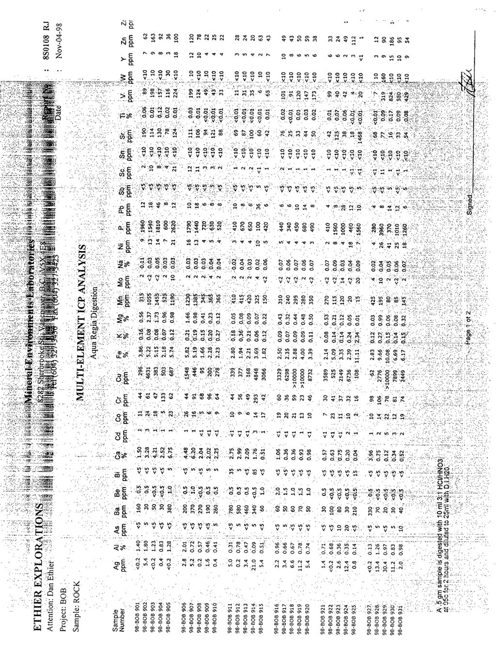
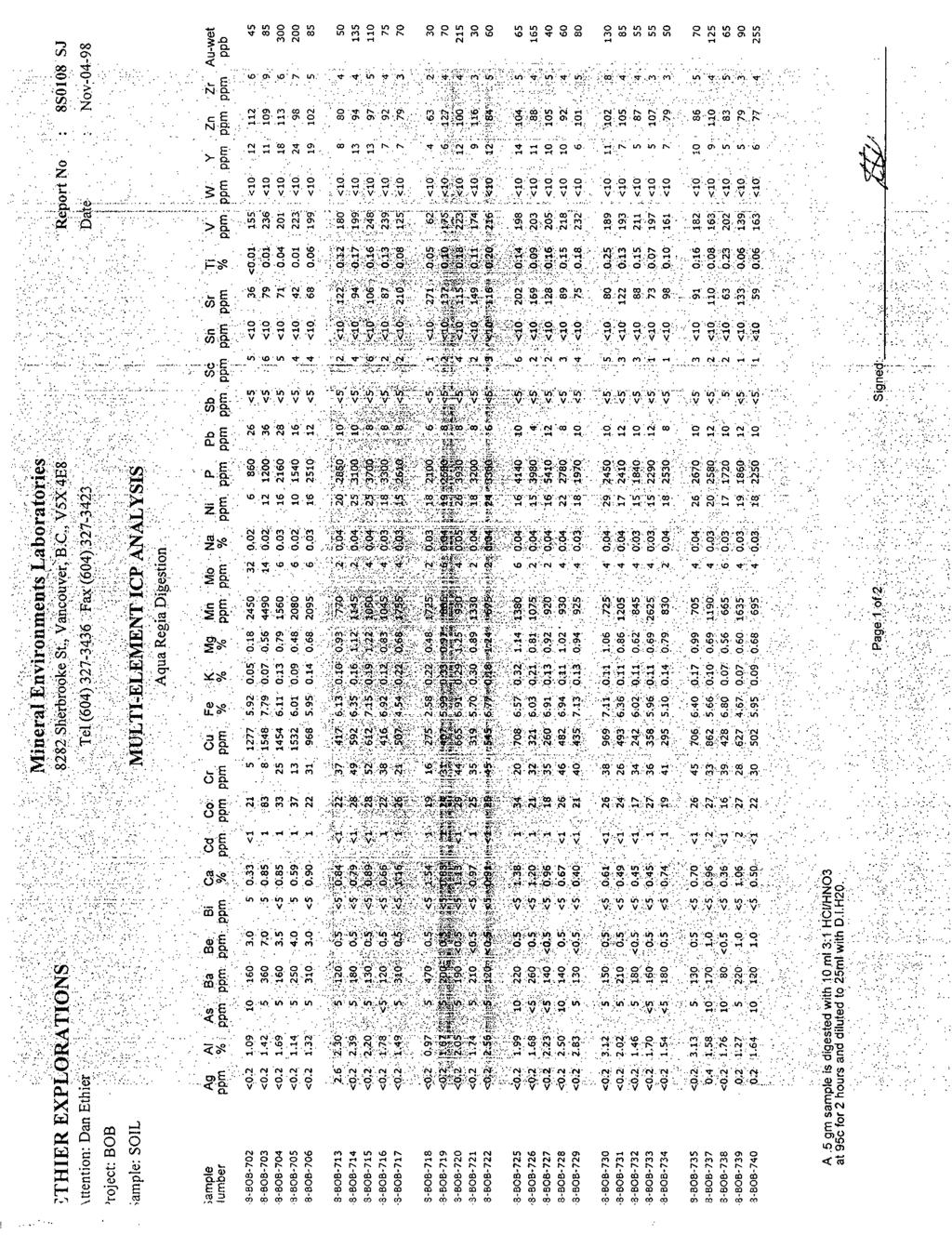
3 Prospector's Assistance Program Report98 0. Ethier Target A Barrington Mtn. Bob Claims NTS 103 G 13 Access; by truck and helicopter from Dease [ake Claims Tenure # ; Bob Claim; 100% D.Ethier. Commodity; Gold, Silver, Copper Deposit type, Porphyry Cu, stockwork and replacement. Geology. Area is underlain by a felsic, multiphase granodiorite pluton 8 in km length. The pluton is intruded by plugs and dykes of pegmatic syenomonzonite, and porphyritic syenite. Large scale alteration, intense faulting, and shearing. Work Performed A successful program was conducted on the Bob claims this year. Several areas that were anomolous were revisited, and trenched. New zones were discovered, extending the known showings. Show Width Average sample width Best over meters 0.93glt Au, 243ppm Cu. 8.28glt Au, 4848 ppm Cu. #914 Zamba 7m 0.64gItAu,0.69% CU. 1.43gltAU-#917, 1.3%CU-#919 Bert 5.6 m glt Au, 0.83 % Cu glt Au, 1.79 % Cu. MI29 Three small soil grids were run.

4 ~.. ~~.,......, I...-..fr i I ~3.4..._:.. y r~576., ~ ~,.~ ~.. 6NX3C"..., ~ '. ~.~ "...&.f. ~ ~.~..'NAJW.:l 20.0!37~1.200~~. ~ ". ::,~.-..:?:-:;:::z:, y'. :A.:- ~f A-R &$.'f..,~!;~, \...." "-....., ~~...,,~ '..., Ea474 JNX6b I.R. 6 I.R I tQ5 55XtW \ZOO77 *6530.SsA4r.653'* 1 \ IO0 'd E9i :13L
5 . -.-.
6 ..,,
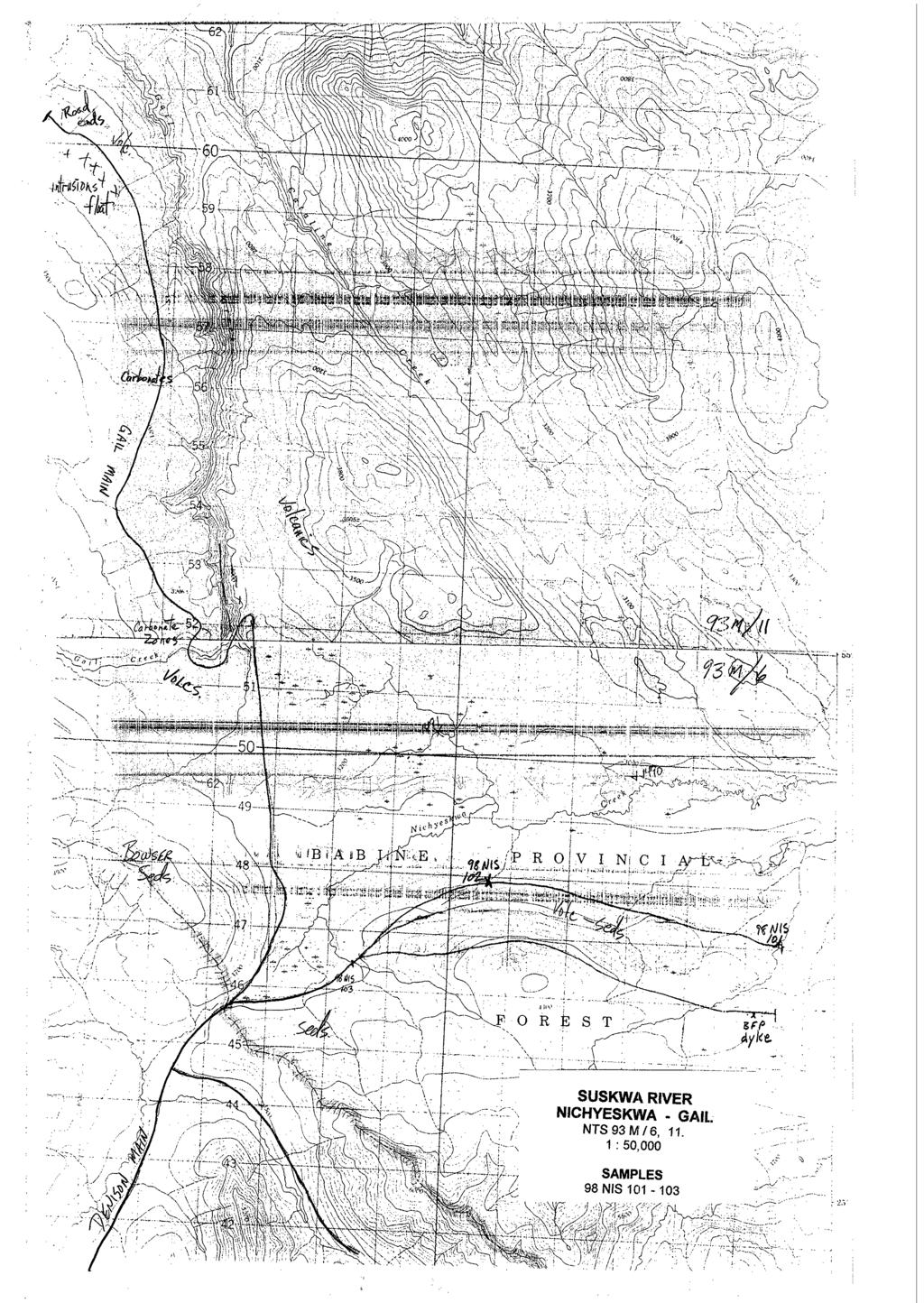
7 Prospector's Assistance Program Report 98 D. Ethier Target B Suskwa River NTS 93 M 6E&W, 7W Access Smithers to the Suskwa forestry road [7km east of New Hazelton] along hyway 16, a number of forestry roads shall be used to get within walking distance of the daily targets, within the region. This region includes Suskwa Main, Hamblin Main, Thoen Main, Denison Main, Nischeskwa Main, Gail Main and Blunt Main. setting. Regional Claims Commodity : Silver, Lead, Zinc, Cu, Au. Deposittype : VolcanogenicMassiveSulfide,andlorpolymetalicveins.Sedimentary Exhalitive. Geology Kasaltic Intrusives, Jurrassic Granodiorites, Bowser Basin Sediments, felsic dykes. Work Performed The areas prospected were Denison Main, Natlan Creek, Nischsskwa Main, Gail Main and Gail creek, Hamblin Main, and Blunt Main. There was not much inspiration on these runs. Areas with anomolous As, Hg in the regional geochem went unexplained for the most part. Although this years pass was not very productive, I am not discouraged, as ground is always opening up. June Nischeskwa 2 days 2 men, prospect roads and creeks. June Gail 1 day Gail Main, Gail cr. Oct 27 I98 Knoll 1 day Unsuccessful river crossing. Nov 2 /98 Hamblin main 2 days Prospect road extension. Follow up 97. Nov Denison,Natlan 1 day checkout highs As, Hg, Unexplained.

8
9
10 ... Supporting data must be submitted with this TECHNICAL REPORT Inform~tion on this form is conlidenlid for we year from the date uf receipt subject 10 the provisions of the Fme-dom of Iaformation Act. Prr~spec/or,s A.s,si.s/unce I'rogmm - G'rrirkhook IYYH ".!S
11 Prospector's Assistance Program Report Ethier Target D 93 NTS M14 E Minfile Golden Wonder M Corneau Claims Tenure # ,7; Golden Wonder Claims; 100% D.Ethicar. Access By truck, from New Hazelton 12 km west. Comeau Rd. Geology ; Red Rose Formation. Pyritic Argilites cut by porphyritic dykes and shears. Deposit Type ; Shear zones, dykes, vein and lens of sulfides. Polymetalic. Commodity ; Gold, copper, cobalt. Work Performed; The mapping program exposed several more old trenchs, which were evaluated. Three soil lines, 39 samples, were taken. Line A, 300 meters long 25m stn N-S line at base of ridge. Line B, 350 meters long, 25m stn, ridge top, N-S. Line C, 300m, along road cuts, north end of hill, E-W line. ***NOTE*** soil samples were destroyed in a truck accident. May I2 198 I day staking, Golden Wonder. June men prospecting in old trenches, mapping. Oct men soil line, mapping and prospecting. Oct men soil line, mapping and prospecting. Nov day prospecting Cap show, south of Golden Wonder.

12 GOLDEN WONDER CLAIMS NTS 93Ml4

13
14 -"--*= :...." ~...~.... COMEAU GOLDEN WONDER CLAIMS NTS 93 M 14, 1 : 50,000 SAMPLES.,/ 97 GW GW I. 98 SOIL LINE A, 300m. 98 SOIL LINE B, 350m. 98 SOIL LINE C, 300rn.

15
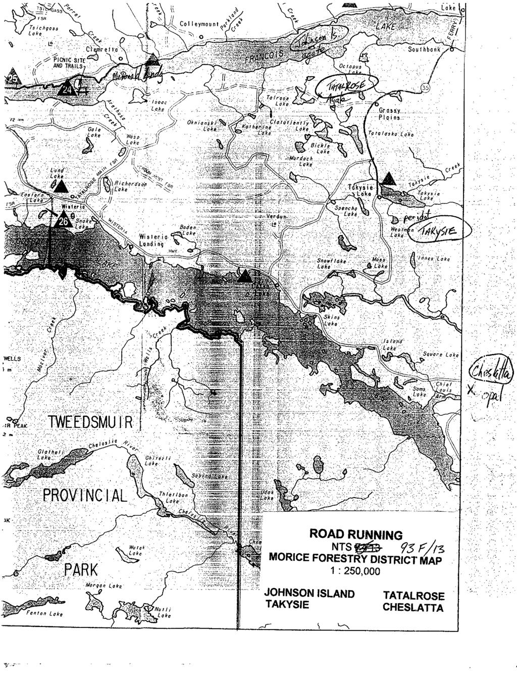
16 Prospector's Assistance Program ReDort Ethier Target C Road Running NTS 93 M, 93 K. Access Commodity : Burns Lake District -forestry roads. Tatalrose road, Francois Lake, Pinekut lake, Binta lake, Cheslatta lake, Semi precious stones, primarily agate, opal (precious), peridote. Deposit type Epithermal enviroment Geology ; Ootsa lake formation. Work Performed Numerous occurrences of semi-precious rocks are in this region. Effort will be made to evaluate these showings to determine if they have production possibilities. Aug Johnson Is Agate, beach wash, not suitable for production. Aug Takysie Lk, Peridot, [and owner denied access, failed to find by water Aug Cheslatta Lk Opal common opal, too sparse. Aug Tatalrose Agate searching for show, prospecting outlying areas. Aug Tatalrose Agate 250 meter zone, green, brown, black. Production Possibilities.
17

18
19
20

21

22
23

24 ,,.., ' Cer&dbi, '.', ~.... :....,.... I,... I ""., ,&;: ". "_ ,......,, LahoratOrier...:....;.....~ :

25

26
CONTENTS. Location, Access and History...6. Tenure Status and Geology Regional Andy Property Geology Map...9
 TYPE OFWORK IN THIS REPORT EXTENT OF WORK (rn METRTC UNITS) ON WHICH CLAIMS PROJECT COSTS APPORTIONED (incl. support) GEOLOGICAL (scale, area) Ground, mapping Photo interpretation GEOPHYSICAL (line-kilometres)
PROSPECTORS ASSISTANCE PROGRAM MINISTRY OF ENERGY AND MINES
 BRITISH COLUMBIA PROSPECTORS ASSISTANCE PROGRAM MINISTRY OF ENERGY AND MINES GEOLOGICAL SURVEY BRANCH PROGRAM YEAR: 1999/2000 REPORT #: PAP 99-l 6 NAME: KIM ANSCHETZ PROSPECTORS TlEPORT on the 99 LOUIS
Prospecting Report 'S Office i DB Property, B.C. -J Negro Creek Nelson Mining District NTS 82F.050. Operator: Kootenay Gold Inc.
 . '.' I"' i9 12 Prospecting Report 'S Office i DB Property, B.C. -J Negro Creek Nelson Mining District NTS 82F.050 Operator: Kootenay Gold Inc. Owner: Darlene Lavoie Work Performed Summer of 2007 Report
NEW HAZELTON, OMINECA M.D.,
 PROSPECTING REPORT JUDI 1 TO 6 MINERAL CLAIMS NEW HAZELTON, OMINECA M.D., B.C. MAP 93M/4E, LAT. SS014'N, LONG. 127'33'W OWNED BY: A. L'ORSA ANTHONY L'ORSA Smithers, B.C. 21 February, 1981 TABLE OF CONTENTS
The Cobalt Rainbow. Airborne geophysical maps show that a north trending aeromagnetic high suggests further undiscovered mineralisation.
 The Cobalt Rainbow The property is located on Greenstone Creek, approximately 4.8 kilometres south west of the creek mouth. The property is located about 24 km due west of Campbell River, in the east-central
for the Greenwood Mining Division, B.C. NTS 82E/7W Latitude 49' 27' W, Longitude 118' 5 Prepared by a= D. Dylan Watt, B.Sc.
 t. b LOGnO: 37~ -08 m. ACTIO#: for the AMP AMP 2 AMP 3 t AMP 4 CLAIMS Greenwood Mining Division, B.C. NTS 82E/7W Latitude 49' 27' W, Longitude 8' 5 %E c,w zc *& a w Prepared by a= -4c. D. Dylan Watt, B.Sc.
Geology Geologists and Prospectors
 Geology Geologists and Prospectors David Lefebure and JoAnne Nelson BC Geological Survey April 17, 2008 Ministry of Energy and Mines Geology - A type of Geoscience is the study of the Earth, the materials
FIRST YEAR ASSESSMENT REPORT PROSPECTING LICENCE 16512M MARYSTOWN AREA, BURIN PENINSULA NTS 1M/3
 FIRST YEAR ASSESSMENT REPORT OF PROSPECTING ON LICENCE 16512M MARYSTOWN AREA, BURIN PENINSULA NTS 1M/3 BY NATHANIEL NOEL MSc. FOR E. MICHELE NOEL MINERAL LICENCES: 16512 M WORK CONDUCTED: MID-SEPTEMBER
JV Project Portfolio Executive Summary: Bruce Smith
 JV Project Portfolio Executive Summary: Bruce Smith September 5, 2012 Disclaimer Forward-Looking Statements This presentation contains forward-looking statements, including but not limited to comments
for the Greenwood Mining Division, B.C. NTS 82E/7W 29' W, Longitude 118' 53' N Prepared by D. Dylan Watt, B.Sc.
 for the FltE NO: u VOLT 1, VOLT 2, VOLT 3, & VOLT 4 CLAIMS Greenwood Mining Division, B.C. NTS 82E/7W Latitude 49' 29' W, Longitude 118' 53' N Prepared by D. Dylan Watt, B.Sc. #309-1996 Trutch Street Vancouver,
ASSESSMENT REPORT. Geochemical and Geological Surveys. on the. Gooch#1-4. Mineral Claims. Omenica Mining District NTS 93L/7W
 f- GEOLOGICAL BRANCH ASSESSMENT REPORT ASSESSMENT REPORT Geochemical and Geological Surveys on the Gooch#1-4 Mineral Claims Omenica Mining District NTS 93L/7W LAT: 54O25'W LONG: 126O26'W Operator: SMD
49" 3-4 I4 I \ Y 59 tj
 ASSESSMENT REPORT Mary 4 FORT STEELE M.D. NTS 82G/5W 49" 3-4 4 \ Y 59 tj Owner: St. Eugene Mining Corporation Limited Operator : St. Eugene Mining Corporation Limited Author: John R. Wilson Date Submitted:
State Metallic Minerals Lease Sale Minnesota s Vermilion Gold District
 State Metallic Minerals Lease Sale Minnesota s Vermilion Gold District State Metallic Minerals Lease Sale Notice of Intent Scale 1:100,000 State Metallic Minerals Lease Sale This portion of the lease sale
PRECIOUS METALS. owner. JMT Services Corp. GEOCHPlICAL SAMPLING CHELASLIE WCE, NORTH CENTRAL, B.C. OMINECA MINING DIVISION NTS 93F/5E & 6W
 PRECIOUS METALS REPORT ON 1980 RECONNAISSANCE GEOCHPlICAL SAMPLING CHELASLIE WCE, NORTH CENTRAL, B.C. OMINECA MINING DIVISION NTS 93F/5E & 6W LATITUDE 53O28 N LONGITUDE 125O31 W DATES Qp WORK: JULY 10
DSM SYNDICATE DISCOVERS POLYMETALLIC MINERALIZATION WITH TALUS GRAB SAMPLES CONTAINING UP TO PERCENT LEAD AND 18
 DSM SYNDICATE DISCOVERS POLYMETALLIC MINERALIZATION WITH TALUS GRAB SAMPLES CONTAINING UP TO 92.8 GRAMS PER TONNE GOLD, 13,643 GRAMS PER TONNE SILVER, 13.85 PERCENT LEAD AND 18.65 PERCENT COPPER FROM DIFFERENT
Copper and Zinc Production, Disciplined Growth. S I T E V I S I T O C T O B E R % Owned Projects
 Copper and Zinc Production, Disciplined Growth. S I T E V I S I T O C T O B E R 2 0 1 6 100% Owned Projects Serbia assets Timok Magmatic Complex Rakita Joint Venture 4 exploration permits in the Bor region,
lat ' N Long ' W
 305 7 ec1;, REPORT ON THE JERY CLAIMS OF POLA RESOURCES LTD. NTS 93L/16 0 0 lat. 54 45' N Long. 126 22' W BABIXE LAKE AREA OMINECA MINING DIVISION, B.C. PAUL PLICKA CONSULTING GEOLOGIST DECEMBER 30, 1981
Location/Identification
 MINFILE Detail Report BC Geological Survey Ministry of Energy, Mines and Natural Gas and Responsible for Housing Location/Identification MINFILE Number: 092L 178 National Mineral Inventory Number: 092L14
SECOND and THIRD YEAR ASSESSMENT REPORT PROSPECTING LICENCE M, ROCK CUT PROPERTY, NTS 1N/12, NEWFOUNDLAND. ROY FRENCH (licence holder )
") SECOND and THIRD YEAR ASSESSMENT REPORT Of PROSPECTING On LICENCE 013704M, ROCK CUT PROPERTY, NTS 1N/12, NEWFOUNDLAND. By ROY FRENCH (licence holder ) Work Conducted: Sept. 17, 2008 Nov. 03, 2009 Total
SECOND and THIRD YEAR ASSESSMENT REPORT Of PROSPECTING On LICENCE 013704M, ROCK CUT PROPERTY, NTS 1N/12, NEWFOUNDLAND. By ROY FRENCH (licence holder ) Work Conducted: Sept. 17, 2008 Nov. 03, 2009 Total
For personal use only
 10 July 2012 Encouraging New Gold Results from Gunung Rosa Drilling Highlights Assay results from three drill holes at depth under the Cap Palu section confirm significantly wider intercepts of gold-copper-base
PROSPECTING REPORT. Silver Dollar Property. EVENT # TENURE # Tenure Name: GPEX Silver Dollar
 2008-2009 PROSPECTING REPORT Silver Dollar Property EVENT # 4267989 TENURE # 555462 Tenure Name: GPEX Silver Dollar Similkameen Mining Division Map 092H Central Coordinate Reference 120 06 26.9 W Longitude
PROSPECTING REPORT. re. Minera.1 C laims
 PROSPECTING REPORT re. Minera.1 C laims P R 1 Record #3052 (6) P R 2 Record #3053 (6) p R 3 Record #3054 (6) at Ilong.129, Latt. 58 20' in the Two Mile Creek area of Turnagain River drainage system in
12 tons of high-grade ore was mined from the No. 1 vein with an average grade of 13 g/t gold, 3,250 g/t silver and 23.3% lead.
 DUNWELL MINE GROUP The Dunwell Mine Group (Dunwell, Dunwell East, Bear River/MM and Silvershot properties), which includes the historic, past-producing Dunwell mine, is located 8 km northeast of Stewart
UNION MINIERE EXPLORATIONS AND MINING CORPORATION LIMITED ASSESSMENT REPORT ON FITINAT MINERAL CLAIM. Alberni Mining Division Record No.
 M F )( UNION MINIERE EXPLORATIONS AND MINING CORPORATION LIMITED Suite 200, 4299 Canada Way, Burnaby, B.C. V5G 1 H4 Telephone (604) 437-9491 ASSESSMENT REPORT ON GEOCHEMICAL SOIL SURVEYS AND ROCKSAMPLING
NEWS RELEASE FOR IMMEDIATE RELEASE: MARCH 5, 2018
 NEWS RELEASE FOR IMMEDIATE RELEASE: MARCH 5, 2018 Eskay Mining provides update on ongoing geological review - Targeting E&L-Type Nickel-Copper-PGE and Eskay-Type VMS Potential on Its Golden Triangle Holdings:
ASSESSMENT REPORT ON THE PEAVINE PROJECT. DGW & Associates # Alberni Street, Vancouver, British Columbia, V6E 4V2
 ASSESSMENT REPORT ON THE PEAVINE PROJECT KAMLOOPS MINING DIVISION BRITISH COLUMBIA NTS 082M 12 Latitude 51 36' 19.0"North -- Longitude --119 47' 27.0"West UTM Zone 11, NAD 83 5720827N 306744E Prepared
American Creek Resources is a precious metals exploration company with an impressive portfolio of high-potential gold
 American Creek Resources is a precious metals exploration company with an impressive portfolio of high-potential gold and silver projects in British Columbia. These include properties in B.C.'s prolific
For personal use only
 South America s Emerging Gold Explorer ASX Release 22 November 2012 OUTSTANDING GEOPHYSICS RESULTS FROM ALUMBRE AND QUINUAL CONCESSIONS HIGHLIGHTS Independent review of the Alumbre and Quinual concessions
GEOLOGIC SETTING OF THE WADSWORTH VEIN: AN INTRUSIVE-RELATED GOLD DISCOVERY NEAR TERRACE, B.C.
 WADSWORTH VEIN By Paul J. Wojdak, Wayne Bulmer and Daryl J. Hanson LOCATION: Lat. 54 57 33 N Long. 128 50 09 W (103I/15W) CLAIMS: ACCESS: SKEENA MINING DIVISION. The property is located in the Cedar River
ON THE LOST GOLD PROPERTY
 ON THE LOST GOLD PROPERTY NELSON MINING DIVISION BRITISH COLUMBIA Latitude: 49 18 North Longitude: 117 29.West TRIM MAPS: 82F1023,033 NTS: 8tF/5,6 By: Fred Critchlow . TABLE OF CONTENTS r PAGE lutroduction
A New Direction. Copper-Gold Deposit at Thor TSX.V:COL. August 11, May 2013
 A New Direction Copper-Gold Deposit at Thor August 11, 2016 May 2013 TSX.V:COL FORWARD LOOKING STATEMENTS This presentation includes certain forward-looking information or forward-looking statements for
PROSPECTING REPORT. Medallion Property. EVENT # TENURE # Tenure Name: GPEX CLVIII Medallion
 2006-2007 PROSPECTING REPORT Medallion Property EVENT # 4167980 TENURE # 540362 Tenure Name: GPEX CLVIII Medallion Watson Bar Region Clinton Mining Division Map 092O Central Coordinate Reference Long.
VANCOUVER, B.C. Tri 082F/ F/059
 GEOCHEMCAL REPORT t MAY L, 2006 Whbpper Mineral Claims Ailsa Lake Area Gold comm~ss16fl8f"s Offim on Mining Division VANCOUVER, B.C. Tri 082F/058 082F/059 3792 E 5486438 N Operator Kootenay Gold nc. Suite
TABLE OF CONTENTS APPENDICES SUMMARY DRILL LOG STATEMENT OF QUALIFICATION STATEMENT OF EXPENDITURES LIST OF FIGURES
 ASSESSMENT WORK REPORT DIAMOND DRILLING PROGRAM AUGUST AND SEPTEMBER, 1980 ON CLAIMS Molly Tom 1-4 and 8 Omineca Mining Division NTS 93M/llU 55'35'N, 127"29'W by David A. Bending Owner: Operator: Texasgulf
GEOCHEMICAL AND PROSPECTING REPORT. RC ly 2,3,4 CLAIMS
 p- ON GEOLOGlCAL SURVEY BRANCH ASSESSMENT REPORTS - DATE RECFl'dFD AFR 0 1 19% GEOCHEMICAL AND PROSPECTING REPORT THE RC ly 2,3,4 CLAIMS IARD MINING DIVISION BRIT1 S H COLUMBIA 94E/EI W LATITUDE 57" 48'
A GUIDE TO WRITING AN ASSESSMENT REPORT ON YOUR CLAIMS
 A GUIDE TO WRITING AN ASSESSMENT REPORT ON YOUR CLAIMS PLEASE NOTE! In the following pages, suggestions and advice are in italics, under each heading. Use as a guideline only. Items in bold should be changed
Prospecting Report Moore Creek
 Prospecting Report Moore Creek Area {.% \..\ F' -2 Assessment Report 4 Anthony L'Orsa, PGeo 7 October 2004 TABLE OF CONTENTS Page SUMMARY... INTRODUCTION... DISCLAIMER... LOCATION AND ACCESS... PHYSIOGRAPHY
HDN MINERAL PRO iperty
 HDN MINERAL PRO iperty ROCK SAMPLE GEOCHEMISTRY ASSESSMENT REPORT 2010 OMINECA MINING DIVISION, BRITISH COLUMBIA 93L047 LATITUDE: 54 29' 16.9" N LONGITUDE: 126 39' 39.8" W GPS: NAD 83 UTM ZONE 9 NORTHING:
ASX Announcement. 28 January Drill results indicate large Porphyry Copper Gold System at Peenam
 ASX Announcement 28 January 2010 Drill results indicate large Porphyry Copper Gold System at Peenam Highlights: 270 metres of visible copper (gold) mineralisation in first diamond core hole at Peenam Prospect
TSX-V NNA
 TSX-V NNA www.nadina.com LOCATED in Central BC 43KM south of Houston BC On the Morice River/Owen Lake Forestry Road to Huckleberry (75km) TSX-V NNA www.nadina.com New Nadina Explorations Limited Silver
Exploration in Northwest BC
 Exploration in Northwest BC Paul Wojdak Regional Geologist Minerals North Conference April 18 2008 Q u e s n e l Nechako Bowser S t i k i n e W r a n g e l l Skeena Arch S t i k i n e T e r r a n e Mineral
AiG ON THE EASTRIM mm. Record number KENNJZDY LAKE AREA - ALBERNI MINING DIVISION Map 92Fl3 W
 ON THE EASTRIM mm CLAIM Record number 3799 19 KENNJZDY LAKE AREA - ALBERNI MINING DIVISION Map 92Fl3 W 125" 23' West Lbngitude - 49" 09' North Latitude Walter GUPPY August ZO;i;! t I : AiG272002 TABLE
Prospectors Making NEW Discoveries
 Prospectors Making NEW Discoveries Hans Smit Minerals North 2012 Burns Lake, British Columbia May 2012 BC Needs New Discoveries BC mines and most advanced mineral projects were found decades ago To ensure
ASSESSMENT REPORT MAGNETOMETER SURVEY GOLDEN ROD, GOLDEN ROD #2. Long.: General Delivery, Vananda, B. C.
 ASSESSMENT REPORT MAGNETOMETER SURVEY GOLDEN ROD, GOLDEN ROD #2 t=/ NTS 92~110w Lat.: Long.: 49O 44' N 124O 34' W Owner: E. Johanson General Delivery, Vananda, B. C. Operator: Rhyolite Resources I nc.
BCGold Corp. Discovery Driven
 BCGold Corp. Discovery Driven Sickle-Sofia Property Copper-Gold Porphyry Discovery in the Toodoggone Camp! Cautionary Statement This presentation does not constitute an offer to sell or solicitation of
Structural Analysis Using Hillshade Imagery. on the. LLC Property
 Structural Analysis Using Hillshade Imagery on the LLC Property Liard Mining Division NTS 104F/16W Latitude: 57 53' 47'' N Longitude: 132 03' 06'' W Owner Garry John Payie 3714 Raymond Street South, Victoria,
twd$ yqsi+hca
 -t@~cl--t,i twd$ yqsi+hca C ASSESSMENT REPORT ON THE OR0 1-5 CLAIMS NEAR GOLDBRIDGE, B.C. Lillooet Mining Division N.T.S. 92 J / 15 W Long. 122 51.5 W. Lat. 50 47.5 N. Owned by Levon Resources Ltd. Optioned
For personal use only
 25 January 2017 HIGH GRADE ZINC, LEAD AND SILVER RESULTS UPDATE Korab Resources Ltd ( Korab, or Company ) () refers to the ASX report dated 23 November 2016 which discussed the review of historical RC
TITLE PAGE PROSPECTING REPORT. on the. Slil\lTINEL PEAK MINERAL CLAIM KENNEDY RIVER AREA. hlbehii1 MINING DIVISION NTS 92 F/6
 TITLE PAGE PROSPECTING REPORT on the Slil\lTINEL PEAK MINERAL CLAIM KENNEDY RIVER AREA hlbehii1 MINING DIVISION NTS 92 F/6 Latitude 49' 15' Longitude 125' 22' Walter Guppy Owner and operator TABLE OF COBTENTS
PROSPECTORS ASSISTANCE PROGRAM MINISTRY OF ENERGY AND MINES
 BRITISH COLUMBIA PROSPECTORS ASSISTANCE PROGRAM MINISTRY OF ENERGY AND MINES GEOLOGICAL SURVEY BRANCH PROGRAM YEAR: 1994195 REPORT #: PAP 94-48 NAME: LLOYD ADDIE BRITISH COLUMBIA PROSPECTORS ASSISTANCE
3. GEOLOGY. 3.1 Introduction. 3.2 Results and Discussion Regional Geology Surficial Geology Mine Study Area
 3. GEOLOGY 3.1 Introduction This chapter discusses the baseline study of the geology and mineralization characteristics of the mine study area. The study consolidates existing geological data and exploration
MINFILE DETAILS. Occurrence Number: 105D 203 Occurrence Name: GRUMPY Occurrence Type: Hard-rock Status: Drilled Prospect
 MINFILE DETAILS Occurrence Number: 105D 203 Occurrence Name: GRUMPY Occurrence Type: Hard-rock Status: Drilled Prospect Aliases: Les 2 Deposit Type(s): Vein Polymetallic Ag-Pb-Zn+/-Au Location(s): 60 54'17.87"
1 FILMED 1. FILE NO:!..rsrru -* -. GRAND TWO CLAIM
 FILE NO:!..rsrru -* -. GRAND TWO CLAIM REPORT ON 1993 ASSESSMENT WORK GRAND TWO CLAIM REC. NO. 301849 NELSON MINING DIVISION NTS MAP SHEET 82F6/W 49 25'51" NORTH 117 18'08" WEST 1 FILMED 1 AUTHOR: R. Jordan,
ISKUT RIVER - TELEGRAPH CREEK: NEW EXPLORATION OPPORTUNITIES IN THE BC REGIONAL GEOCHEMICAL DATABASE
 ISKUT RIVER - TELEGRAPH CREEK: NEW EXPLORATION OPPORTUNITIES IN THE BC REGIONAL GEOCHEMICAL DATABASE By Ray Lett 1 and Wayne Jackaman 2 KEYWORDS: Regional stream sediment surveys, archival samples, gold,
Reconnaissance. Of the. Denis mineral claims. Situated at Kilometer 844 of the Alaska Highway. Liard Mining Division. Northeastern British Columbia
 Reconnaissance Of the Denis mineral claims Situated at Kilometer 844 of the Alaska Highway Liard Mining Division Northeastern British Columbia N.T.S. 94M.075 Latitude 59 42 25 Longitude 127 13 12 Field
ASSESSMENT REPORT PROSPECTING PROGRAM ION/DIRTY JACK PROPERTY NELSON MINING DIVISION N.T.S. MAP SHEET 82F.023 UTM COORDINATES N E
 ASSESSMENT REPORT PROSPECTING PROGRAM ION/DIRTY JACK PROPERTY NELSON MINING DIVISION N.T.S. MAP SHEET 82F.023 UTM COORDINATES 5454800N - 0455235E Work Performed Summer 2007 OWNER >* ' Tom Kennedy >8 404-22
%+ '$# $) %, %*$ " $ $ ' %' !()'-!" %( %"%! " *'+ - % %$! $)! " $)!" !$ ' "! )( ! $ '%& ')- % % "!#( (( ((# $) ' ) ((* & *# ' % %"*# ( !!
 %, %*$ $ $ ' %' !()'-! %( %%! *'+ - % %$! $)! $)! !$ ' ! )( ! $ '%& ')- % % !#( (( ((# $) ' ) ((* & *# ' % %*# ( !!") 001L/14/0218 First Year Assessment Report of Prospecting, Rock and Stream Sediment Sampling On Licence 18880M, NTS 1L/14 Burin Peninsula Newfoundland and Labrador Submitted by: Keith Kelloway Work year:
001L/14/0218 First Year Assessment Report of Prospecting, Rock and Stream Sediment Sampling On Licence 18880M, NTS 1L/14 Burin Peninsula Newfoundland and Labrador Submitted by: Keith Kelloway Work year:
Tameapa Regional Geology
 Tameapa Project 1 Tameapa Regional Geology History San Francisco Mines of Mexico Ltd. (San Francisco), which completed an exploration program, including six drill holes (1,157 m) between 1956 and 1959.
Sombrero Butte Copper Project Arizona, USA
 Sombrero Butte Copper Project Arizona, USA January 2017 Sombrero Butte Project Location COPPER CREEK DEPOSIT (7.75 Billion Lbs Cu) SAN MANUEL KALAMAZOO MINE (BHP) (10.4 Billion Lbs Cu) SOMBRERO BUTTE EXPLORATION
McVicar Lake Gold Property Lang Lake Greenstone Belt Ontario. Argo Gold Inc. (ARQ)
") McVicar Lake Gold Property Lang Lake Greenstone Belt Ontario Argo Gold Inc. (ARQ) Forward Looking Statements This presentation may contain forward-looking statements that involve a number of risks and
McVicar Lake Gold Property Lang Lake Greenstone Belt Ontario Argo Gold Inc. (ARQ) Forward Looking Statements This presentation may contain forward-looking statements that involve a number of risks and
First Year assessment Report on Prospecting and Rock sampling, King George property, License M NTS 12A/05 Newfoundland and Labrador.
 First Year assessment Report on Prospecting and Rock sampling, King George property, License 016679M NTS 12A/05 Newfoundland and Labrador. Submitted by Shawn Rose For Shawn Rose January 2011 Work year
ASSESSMENT REPORT TITLE PAGE AND SUMMARY
 ASSESSMENT REPORT TITLE PAGE AND SUMMARY TITLE OF REPORT: 2016 Prospecting Report Sphynx Claim TOTAL COST: $167.56 AUTHOR(S): Giacomo Grassi SIGNATURE(S): NOTICE OF WORK PERMIT NUMBER(S)/DATE(S): STATEMENT
PROSPECTING REPORT TENURES # / / CLAIM NAMES OLD SETTLER; OLD SETTLER1; OLD SETTLER2
 2011 PROSPECTING REPORT EVENT - 5160426 TENURES # 688183 / 691903 / 691905 CLAIM NAMES OLD SETTLER; OLD SETTLER1; OLD SETTLER2 COAST CRYSTALINE BELT REGION NEW WESTMINSTER MINING DISTRICT MAP - 092H GPS
Kalimantan Gold Corporation Limited
 Kalimantan Gold Corporation Limited BAROI PROSPECT Far Eastern Zone High-Grade Copper Silver Gold October 2003 Baroi Prospect Far Eastern Zone High-Grade Copper Silver Gold Introduction Today KGC have
GEOLOGICAL MAPPING REPORT ON THE ASH MINERAL CLAIM OSOYOOS MINING DIVISION ASHNOLA RIVER MAP SHEET NTS M092,H019 MCBRIDE CREEK AREA, ASHNOLA RIVER,
 GEOLOGICAL MAPPING REPORT ON THE ASH MINERAL CLAIM OSOYOOS MINING DIVISION ASHNOLA RIVER MAP SHEET NTS M092,H019 LATITUDE 49 o O6, LONGITUDE 120 o 22 MCBRIDE CREEK AREA, ASHNOLA RIVER, KEREMEOS, B.C. CANADA
Scadding Property Sudbury District, Ontario
 FOR IMMEDIATE RELEASE Northern Sphere Mining Corp. optimizes mineral targets on its Sudbury Nickel Belt and Arizona Porphyry Copper properties Toronto, Ontario April 5, 2018 - Northern Sphere Mining Corp.
RECENT RESULTS FROM THE COMPANY S EXPLORATION PROGRAMME AT PROSPERO (PAMPAMALI NORTH) PROSPERO HIGHLIGHTS
 PROSPERO HIGHLIGHTS") 7 October 2015 Hunter Resources plc ( Hunter or the Company ) (AIM: HUN) RECENT RESULTS FROM THE COMPANY S EXPLORATION PROGRAMME AT PROSPERO (PAMPAMALI NORTH) The Company is pleased to announce the results
7 October 2015 Hunter Resources plc ( Hunter or the Company ) (AIM: HUN) RECENT RESULTS FROM THE COMPANY S EXPLORATION PROGRAMME AT PROSPERO (PAMPAMALI NORTH) The Company is pleased to announce the results
SELF POTENTIAL SURVEY OVER THE JAY GROUP, INVERMERE AREA GOLDEN MINING DIVISION, BFUTISH COLUMBIA NTS 82W8W7 82W9W LATLONG 50 30' ' FOR
 - GEOLOGICAL SURVEY BRANCH ASSESSMENT REPORTS -- -- DATE RECEI?/::D 06T 10 1996 - SELF POTENTIAL SURVEY OVER THE JAY GROUP, INVERMERE AREA GOLDEN MINING DIVISION, BFUTISH COLUMBIA NTS 82W8W7 82W9W LATLONG
VICTORIA, BC FILE NO,
 FILE NO, VICTORIA, BC DEC - 7 2006 BFUTISH COLUMBIA Ministry of Energy & Mines Energy & Minerals Division Geological Survey Branch ASSESSMENT REPORT TITLE PAGE AND SUMMARY TITLE OF REPORT [type of survey(s)]
A Report on a Magnetometer Survey. Division, British Columbia. Gypsy 1-32 and Gypsy 1 Fr-9 Fr. 27 miles north of Smithers
 - A Report on a Magnetometer Survey on the Gypsy Claims, Omineca Mining Division, British Columbia Covering: Gypsy 1-32 and Gypsy 1 Fr-9 Fr Located: 27 miles north of Smithers Latitude 55O11' N Longitude
Verification Rock/Soil Geochemical Survey on the Knight Inlet Property
 Verification Rock/Soil Geochemical Survey on the Knight Inlet Property Vancouver Mining Division British Columbia NTS 092K14 o on 9 W s UTM Zone 10, NAD 83 5635430N 339280E For Owner & Operator: St. Elias
TUDOR GOLD CORP. Turning Gold Claims into Gold Mines. February, 2019 TSX-V: TUD Frankfurt: TUC.F
 TUDOR GOLD CORP. Turning Gold Claims into Gold Mines February, 2019 Forward-Looking Statement No stock exchange, securities commission or other regulatory authority has approved or disapproved the information
PROSPECTING REPORT TENURES # / / CLAIM NAMES OLD SETTLER; OLD SETTLER1; OLD SETTLER2
 2010 PROSPECTING REPORT EVENT # 4820658 TENURES # 688183 / 691903 / 691905 CLAIM NAMES OLD SETTLER; OLD SETTLER1; OLD SETTLER2 COAST CRYSTALINE BELT REGION NEW WESTMINSTER MINING DISTRICT MAP - 092H GPS
Mishi Lake Gold Property Mishibishu Lake Area, Wawa
 Mishi Lake Gold Property Mishibishu Lake Area, Wawa Location, Accessibility, Infrastructure and Local Resources The property is located 40 km west of Wawa, Ontario, in the Mishibishu Lake Area, Sault Ste.
W. 1.NELSON Jr. P. ENG.
 GEOCHEMICAL AND GEOPHYSICAL SURVEY SNO GROUP CLAIMS W. 1.NELSON Jr. P. ENG. NORANDA EXPLORATION COMPANY, LIMITED OMINECA MINING DIVISION AUG. 17, 1971 - AUG. 29, 1971 TABLE OF CONTENTS - Page INTRODUCTION
GEOCHEMICAL REPORT ON THE YEP CLAIMS, Clinton Mining Division. P.E. Fox, PhD. P.Eng.
 CLNTON 1 MNNG RECORDER GEOCHEMCAL REPORT ON THE YEP CLAMS, Clinton Mining Division P.E. Fox, PhD. P.Eng. Fox Geological Consultants Ltd 204-635 Victoria St. Kamloops, B. C. August 5, 1974 Work done: Juge
Elephant Mountain, Alaska Intrusive Related Gold Project July Option to Earn 100%
 Elephant Mountain, Alaska Intrusive Related Gold Project July 2018 Option to Earn 100% CORPORATE Corporate DISCLOSURE Disclosure The information contained herein, while obtained from sources which we believe
FIRST 2 DRILL HOLES AT NAKRU-2 PROSPECT BOTH INTERSECT SIGNIFICANT HIGHER GRADE COPPER MINERALISATION
 ADDRESS PHONE PO Box 6965 +61(07) 5592 1001 Gold Coast Mail Centre FAX Qld 9726 Australia +61 (07) 5592 1011 EMAIL ABN 54 126 490 855 info@coppermoly.com.au WEBSITE www.coppermoly.com.au ASX Announcement
EXPLORATION and DEVELOPMENT REPORT. Conrad Creek. PLACER and MINERAL CLAIMS SOUTHEAST BRITISH COLUMBIA
 EXPLORATION and DEVELOPMENT REPORT on Conrad Creek PLACER and MINERAL CLAIMS in SOUTHEAST BRITISH COLUMBIA Ed Friesen, BSc.E.E., P. Eng 8 Lake Placid Rise SE Calgary, Alberta T2J 5B5 April 2009 1 P age
RECONNAISSANCE GEOCHEMICAL SURVEY
 RECONNAISSANCE GEOCHEMICAL SURVEY LEGAL, RITA, LOUISE FR. (CHAPLEAU GROUP) REVERTED CROWN GRANTS CHAPLEAU CREEK AREAJ, SLOC& MINING DIVISION 82 F/11W Lat: 49'44" Long: 117"22'W MINERAL RESOURCES BRANCH
The Gold Hill s Big Chief Showing. Cross Section Line A-A' (Pighin 2014)
") GOLD HILL SUMMARY In 1864 gold fever struck in the south Kootenays east of Cranbrook, British Columbia as placer gold was discovered in the Wild Horse River. What followed was everything one can imagine
GOLD HILL SUMMARY In 1864 gold fever struck in the south Kootenays east of Cranbrook, British Columbia as placer gold was discovered in the Wild Horse River. What followed was everything one can imagine
Haoma Mining NL A.B.N
 Haoma Mining NL A.B.N 12 008 676 177 Registered Office & Head Office: 411 Collins Street, Melbourne, Vic., 3000, GPO Box 2282U, Melbourne, Vic., 3001. Telephone (03) 9629 6888, Facsimile (03) 9629 1250
MINCOR /GOLDEN RIM FIJI JOINT VENTURE SIGNIFICANT NEW EXPLORATION RESULTS
 1 November 2007 MINCOR /GOLDEN RIM FIJI JOINT VENTURE SIGNIFICANT NEW EXPLORATION RESULTS Highlights Very high gold-in-soil sample results up to 17.3 g/t gold have been received from the Banana Creek Prospect.
Sotkamo Silver Mo i Rana and Tampere areas. Erkki Kuronen Chief Geologist, M.Sc., MAusIMM Sotkamo Silver Oy
 Mo i Rana and Tampere areas Erkki Kuronen Chief Geologist, M.Sc., MAusIMM Oy Mo i Rana and Tampere areas Erkki Kuronen Chief Geologist, M.Sc., MAusIMM Oy 2.9.2018 Silver 2 Deposits and Projects develops
SHAMROCK ENTERPRISES INC. CSE Symbol - SRS
 SHAMROCK ENTERPRISES INC. CSE Symbol - SRS 2018 Safe Harbour Statement and disclosure Safe Harbour for Forward Looking Statements: This package contains forward-looking information, in that it describes
For personal use only
 ASX ANNOUNCEMENT ASX: IVG Date: 30 April 2012 Number: 030_300412 MARCH 2012 QUARTERLY REPORT SUMMARY Market Cap A$2.23m ($0.062 p/s) Issued Capital 36,006,006 Assay data and mineral alteration studies
HOWE COPPER MINE PROJECT HIGH GRADE Cu-Ag with Au
 HOWE COPPER MINE PROJECT HIGH GRADE Cu-Ag with Au The Howe Copper Mine property is located approximately 55 kilometres northwest of Vancouver, BC. It is situated at 1431 metres elevation on the eastern
REPORT SOIL GEOCHEMICAL SURVEY. ATTYCELLEY NO. 2 GROUP (Attycelley Mineral Claims No. 7-10)
") REPORT SOIL GEOCHEMICAL SURVEY ATTYCELLEY NO. 2 GROUP (Attycelley Mineral Claims No. 7-10) Situated 7 miles east of north end of Thutade Lake, Omineca Mining Division British Columbia I Department of I
REPORT SOIL GEOCHEMICAL SURVEY ATTYCELLEY NO. 2 GROUP (Attycelley Mineral Claims No. 7-10) Situated 7 miles east of north end of Thutade Lake, Omineca Mining Division British Columbia I Department of I
O ITHIS )WE OF WORK IN I EXTENT OF WORK I I PROJECT COSTS I ON WHICH CLAIMS (IN METRIC UNITS) APPORTIONED (id. support) GEOLOGICAL (scale, area)
WE OF WORK IN I EXTENT OF WORK I I PROJECT COSTS I ON WHICH CLAIMS (IN METRIC UNITS) APPORTIONED (id. support) GEOLOGICAL (scale, area)") Geological Survey Branch TITLE OF REPORT [type of SUNOY(S)] TOTAL COST 1 MINERAL INVENTORY M OWNER@) MAILING ADDRESS -.,-- a 5 -a OPERATOR(S) [who paid ffo the wnk) 2) MAILING ADDRESS 76e2 HWY 97/gm LP
Geological Survey Branch TITLE OF REPORT [type of SUNOY(S)] TOTAL COST 1 MINERAL INVENTORY M OWNER@) MAILING ADDRESS -.,-- a 5 -a OPERATOR(S) [who paid ffo the wnk) 2) MAILING ADDRESS 76e2 HWY 97/gm LP
Airborne Geophysical TOTAL COST: $8, ,
 Ministry of Energy, Mines & Petroleum Resources Mining & Minerals Division BC Geological Survey Assessment Report Title Page and Summary TYPE OF REPORT [type of survey(s)]: Airborne Geophysical TOTAL COST:
CSA Mine Observations Applied to the Development of Regional Exploration Models
 CSA Mine Observations Applied to the Development of Regional Exploration Models 1 Introduction Recent work completed by the geology team has resulted in an improved understanding of the CSA mine system
Silver Phoenix Resources, Inc. Alaska Mineral Property
 Silver Phoenix Resources, Inc. Alaska Mineral Property Tolstoi A Promising Silver-Gold-Copper Polymetallic Project Ready for Exploration and Drill-Testing in 2018 Introduction, Prospect History and Access
Treaty Creek Joint Venture Project
 Treaty Creek Joint Venture Project Highlights: -Potential to host world class gold / copper deposits -Just commenced a multi-million-dollar drill program to define a gold resource(s). -Located in British
Mineral Claims. Aspen Grove Area Nicola Mining Division, British Columbia. Latitude N., Longitude W. NTS Map Sheet 92H/lSE
 Mineral Claims Aspen Grove Area Nicola Mining Division, British Columbia Latitude 49 51 N., Longitude 120 35 W. NTS Map Sheet 92H/lSE James P. Balmer, B.SC., P.Geo. on behalf of Gary Brown November 26,2003
TOPOGRAPHICAL SURVEY REPORT ON THE GREENDROP PROPERTY NEAR CHILLIWACK, B.C. 92-H-3/W
 TOPOGRAPHICAL SURVEY REPORT ON THE GREENDROP PROPERTY NEW WESTMINSTER M.D. NEAR CHILLIWACK, B.C. 92-H-3/W Location: The central pap of the claims is located at coordinates 49 08'N, latitude by 121 26'W,
GEOLOGICAL BRANCH ASSESSMENT RFPORT
 1983 ASSESSMENT REPORT ON GEOCHEMICAL SURVEYS by Ian G. Sutherland on the KRAB CLAIM situated northeast of Black Lake in the Omineca Mining Division 57"15', 127"Ol' NTS 94E/2W, 3E, 6E, 7W owned by KIDD
Summary of Rover Metals Geologic Mapping Program at the Up Town Gold Project, Northwest Territories
 October 13, 2017 Summary of Rover Metals Geologic Mapping Program at the Up Town Gold Project, Northwest Territories Vancouver, British Columbia, Canada - Rover Metals Corp., Rover, is pleased to provide
GEOLOGICAL BRANCH ASSESSMENT REPORT 12. FItE NO: ACTION: THE GOLDEN MINING DIVISION, GOLDEN, Including THE NTS MAP; M82K/15W
 ACTION: FItE NO: Including 1990 GEO-CHEM SURVEY RESULTS -- THE AVD CLAIMS - THE GOLDEN MINING DIVISION, GOLDEN, B.C. NTS MAP; M82K/15W Lat. 50 deg. 55 Min. Long 116 deg. 55 min. For GEOLOGICAL BRANCH ASSESSMENT
Section 1: TITLE PAGE 1. Section 2. TABLE OF CONTENTS 2. Section 3: SUMMARY 6. Section 4. INTRODUCTION AND TERMS OF REFERENCE 11
 Section 2. TABLE OF CONTENTS Section 1: TITLE PAGE 1 Section 2. TABLE OF CONTENTS 2 Section 3: SUMMARY 6 Section 4. INTRODUCTION AND TERMS OF REFERENCE 11 Section 5. STATEMENT OF COSTS 12 Section 6. PROPERTY
ON TRACK FOR DISCOVERY. January
 ON TRACK FOR DISCOVERY http://dsmsyndicate.ca/ January 2018 1 PROJECT GENERATOR MODEL The DSM syndicate is a project generator focused on original discovery resulting from glacial and snowpack recession.