CHARACTERIZATION OF FRACTURES AND THEIR EFFECT ON RESERVOIR DIRECTIONAL FLOW IN TENSLEEP SANDSTONES, WYOMING
|
|
|
- Shauna Philippa Lester
- 6 years ago
- Views:
Transcription
1 CHARACTERIZATION OF FRACTURES AND THEIR EFFECT ON RESERVOIR DIRECTIONAL FLOW IN TENSLEEP SANDSTONES, WYOMING Peigui Yin & Shaochang Wo Enhanced Oil Recovery Institute University of Wyoming Laramie, Wyoming


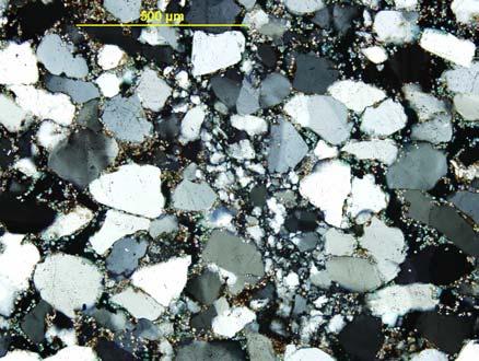
2 TENSLEEP SANDSTONE RESERVOIRS, WYOMING A B A B Presented Reservoir Eolian Sandstone Marine Carbonate Major Reservoirs Cores Outcrops
3 TENSLEEP PRODUCTION Water Cut (%) Recovery Factor (%)
4 FRACTURE TYPES IN TENSLEEP SANDSTONES Gouge-filled fractures Mineral-filled fractures Barriers or baffles Partially-filled fractures Open fractures Conduits


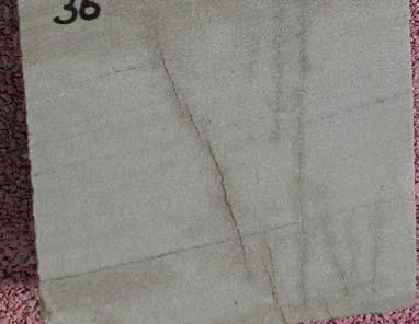
5 Gouge-filled Fractures in Cores


6 Gouge-filled Fractures


7 Mineral-filled Fractures in Cores


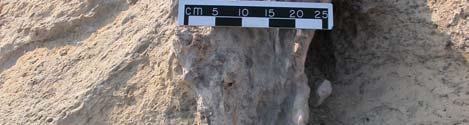
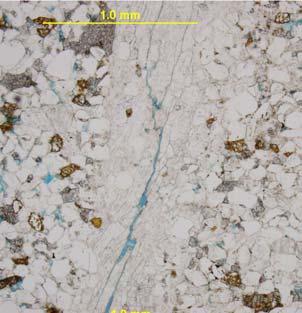
8 Mineral-filled Fractures in Outcrops


9 Partially-filled Fractures in Cores


10 Open Fractures in Cores

11 FAULT AND FRACTURE DISTRIBUTION IN OUTCROPS 1000 ft? Flat Top Mountain


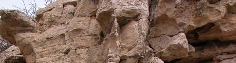
12 Gouge-filled fractures on Outcrops Brokenback Anticline Bighorn Mountain Sinks Canyon Wind River Range Zeisman Dome Bighorn Mountain Cottonwood Creek Ferris Mountain
13 FRACTURE PERMEABILITY AND FRACTURE ORIENTATION IN A RESERVOIR 3-D reservoir structure construction Curvature calculation to indicate fracture intensity Average matrix permeabilities of wells from core analysis and well log data Total permeabilities of wells from matching wells production history Multi-well flow simulation to verify fracture orientation and estimate average fracture/matrix permeability ratio
14 FRACTURE DISTRIBUTION IN CORES (From the Presented Tensleep Reservoir) Fractures Filled Partiallyfilled Open
15 Fracture Spacing vs. Core Porosity 10 Average Fracture Spacing (ft) Average Porosity (%) Average core porosity
16 ESTIMATED TOTAL PERMEABILITY FROM PRODUCTION HISTORY vs AVERAGE MATRIX PERMEABILITY FROM CORES AND WELL LOGS Mahoney Dome: Estimated Permeabilities From Well Productions Estimated Permeability from Production (with Well Number) (total permeability) Average Permeability around Wells, md Average Permeability from Log Correlation (matrix permeability) estimated permeability from production average permeability = fracture permeability (+ -)
17 DISTRIBUTION OF MATRIX PERMEABILITY
18 DISTRIBUTION OF FRACTURE PERMEABILITY Elevation Fracture Permeability + Permeability (Total Perm>Matrix Perm) - Permeability (Total Perm<Matrix Perm) Fractures Filled Partiallyfilled Open


19 CURVATURE DISTRIBUTION FOR THE PRESENTED RESERVOIR STRUCTURE Gaussian Curvature Maximum Curvature Minimum Curvature Mean Curvature Dip Curvature Strike Curvature
20 Curvature vs. Fracture Permeability Curvatures, 10^6/ft (10^9/ft for Gaussian Curvature) Maximum Minimum Gaussian Mean Dip Strike Difference between Production Perm. and Log Correlation Perm., md
21 WELL INTERFERENCE TEST Fracture Orientation Observation Well Active Well
22 Measured and Simulated BHP Drop Down in Well 12 (from well interference test) 1900 N30 o E Simulation matched permeabilities: BHP Drop Down in Observation Well 12, psi Permeability at N30 o E (Ky) = 18 md Permeability at S60 o E (Kx) = 3 md Measured BHP W ell 2 shut-in W ell 19 on S60 o E Simulated BHP Well 16 shut-in W ell 19 shut-in W ell 2 on W ell 17 shut-in Testing Time, days
23 CONCLUSIONS & APPLICATIONS Four different types of fractures are observed in the Tensleep well cores and outcrops: gouge-filled, mineral-filled, partiallyfilled, and open fractures. Open and partially-filled fractures can act as conduits for reservoir flow, whereas gouge- and mineral-filled fractures can act as barriers or baffles. Fracture permeability is estimated by subtracting average matrix permeability (from core analysis and log data) from total permeability (calculated from production history). Curvatures calculated from 3-D reservoir structure may predict fracture intensity but show no good correlation with fracture permeability in the Tensleep sandstones. Fracture orientation is obtained through well interference tests. Multi-well flow simulation is used to verify fracture orientation and estimate average fracture/matrix permeability ratio.
Characterization and Modeling of Naturally Fractured Tensleep Reservoirs
 Characterization and Modeling of Naturally Fractured Tensleep Reservoirs Shaochang Wo, Peigui Yin, Scott Cooper, John Lorenz J A N U A R Y 1 8, 2 0 1 1, D E N V E R A Brief Overview of the Tensleep Reservoirs
Bighorn Basin ROZ Development
 Bighorn Basin ROZ Development David Mohrbacher Enhanced Oil Recovery Institute Presented at the 17 th Annual CO 2 Flooding Conference December 8-9, 2011 Midland, Texas Acknowledgements Dr. Peigui Yin Dr.
CREATION OF MINERAL LOG
 CREATION OF MINERAL LOG Peigui Yin & Shaochang Wo Enhanced Oil Recovery Institute Objectives Creation of mineral logs using traditional well logs, point-counting data, and radial-basis function network
Radial- Basis Function Network Applied in Mineral Composition Analysis
 Radial- Basis Function Network Applied in Mineral Composition Analysis Shaochang Wo & Peigui Yin January 13, 2010, Denver Mineral composition in the Minnelusa Formation can be calculated from the sonic,
Modeling and Simulation of Naturally Fractured Reservoirs
 Modeling and Simulation of Naturally Fractured Reservoirs Prepared for the EORI Joint EOR Commission & Technical Advisory Board Meeting Shaochang Wo EORI, University of Wyoming Laramie, July 23, 2009 2007
Aspects of Waterflooding
 Aspects of Waterflooding Sheena Xie, Hui Pu and Norman Morrow January 13, 21, Denver, CO Projects in Progress at P&SC Group (Led by Morrow N.R.) Improved oil recovery by low salinity waterflooding - Wyoming
Introduction Geology
 Introduction The Wild Horse Anticline is located in the prolific Bighorn Basin of Wyoming about 5 miles northeast of the town of Basin. This structure demonstrates excellent fourway closure encompassing
Quarterly Report Reporting Period Start Date: July 1, 1996 Reporting Period End Date: September, 1996
 TITLE: ANISOTROPY AND SPATIAL VARIATION OF RELATIVE PERMEABILITY AND LITHOLOGIC CHARACTER OF TENSLEEP SANDSTONE RESERVOIRS IN THE BIGHORN AND WIND RIVER BASINS, WYOMING Quarterly Report Reporting Period
Minnelusa Play: The impact of tectonics and an ancient dune field on production
 Minnelusa Play: The impact of tectonics and an ancient dune field on production Steven G. Fryberger ENHANCED OIL RECOVERY INSTITUTE Permian Tectonic Map of Wyoming 200 miles after Inden, et al, 1996 PermoPennsylvanian
MODELING STRANDED OIL IN THE RESIDUAL OIL ZONE
 MODELING STRANDED OIL IN THE RESIDUAL OIL ZONE (Oil-Water Flushing Hydrodyamics) Prepared by: George J. Koperna Jr. Advanced Resources International, Inc. Prepared for: SPE International Conference on
EAS 233 Geologic Structures and Maps Winter Miscellaneous practice map exercises. 1. Fault and separation:
 Miscellaneous practice map exercises 1. Fault and separation: With respect to Map 1, what are (a) the orientation of the fault, and (b) the orientation of bedding in the units cut by the fault. (c) Mark
Strike-Slip Faults. ! Fault motion is parallel to the strike of the fault.
 Strike-Slip Faults! Fault motion is parallel to the strike of the fault.! Usually vertical, no hanging-wall/footwall blocks.! Classified by the relative sense of motion. " Right lateral opposite block
Dual Permeability Model, Teapot Dome Field
 Dual Permeability Model, Teapot Dome Field PETE 4735 5/2/15 Matt Filla Evan Egenolf Kero Samy Matt Covalt Introduction Introduction Context 1 Teapot Dome Powder River basin 9,481 acres Stripper field Tensleep
The 5th Annual Wyoming CO 2
 A P R I L 2 0 1 1 F R O M T H E D E S K O F T H E D I R E C T O R IN THIS EDITION: From the Desk of the Director Residual Oil Zones in the Tensleep Formation Website Development and Design Future EORI
Jim %%m? Bartlesville Project Office U.S. DEPARTMENT OF ENERGY Bartlesville, Oklahoma DOE/BC/ (DE )
") DOE/BC/14897-15 (DE96001269) ANISOTROPY AND SPATIAL VARIATION OF RELATIVE PERMEABILITY AND LITHOLOGIC CHARACTER OF TENSLEEP SANDSTONE RESERVOIRS IN THE BIGHORN AND WIND RIVER BASINS, WYOMING Final Report
DOE/BC/14897-15 (DE96001269) ANISOTROPY AND SPATIAL VARIATION OF RELATIVE PERMEABILITY AND LITHOLOGIC CHARACTER OF TENSLEEP SANDSTONE RESERVOIRS IN THE BIGHORN AND WIND RIVER BASINS, WYOMING Final Report
Reservoir Geomechanics and Faults
 Reservoir Geomechanics and Faults Dr David McNamara National University of Ireland, Galway david.d.mcnamara@nuigalway.ie @mcnamadd What is a Geological Structure? Geological structures include fractures
Characterizing Seal Bypass Systems at the Rock Springs Uplift, Southwest Wyoming, Using Seismic Attribute Analysis*
 Characterizing Seal Bypass Systems at the Rock Springs Uplift, Southwest Wyoming, Using Seismic Attribute Analysis* Yuri Ganshin 1 and Fred McLaughlin 1 Search and Discovery Article #80483 (2015)** Posted
Crustal Deformation Earth - Chapter Pearson Education, Inc.
 Crustal Deformation Earth - Chapter 10 Structural Geology Structural geologists study the architecture and processes responsible for deformation of Earth s crust. A working knowledge of rock structures
Core Technology for Evaluating the Bakken
 Core Technology for Evaluating the Bakken Fundamentals for Reservoir Quality Assessment and Completion Analysis John Kieschnick and Roberto Suarez-Rivera TerraTek 1 Topics Covered Core Technology Changes
3D Time-lapse Seismic Modeling for CO2 Sequestration
 3D Time-lapse Seismic Modeling for CO2 Sequestration Jintan Li Advisor: Dr. Christopher Liner April 29 th, 2011 1 Outline Background/Introduction Methods Preliminary Results Future Work 2 Goal Flow simulation
WP 4.1. Site selection criteria and ranking methodology. Karen Kirk
 WP 4.1 Site selection criteria and ranking methodology Karen Kirk 1 Basic site selection criteria Sufficient depth and storage capacity supercritical CO 2 below 700-800 m (rule of thumb) 2 Variation of
Subsurface Reservoir Characterization for Enhanced Oil Recovery. Mark Tomasso 1
 Subsurface Reservoir Characterization for Enhanced Oil Recovery Mark Tomasso 1 1 Enhanced Oil Recovery Institute, University of Wyoming, Laramie,, Wyoming 82071, USA Presentation Objectives FY2009 project
Minnelusa Core Analysis and Evaluation Project
 Minnelusa Core Analysis and Evaluation Project Collaborative work of EORI with the Minnelusa Consortium and C&PE faculty members, Professors: Alvarado, Morrow and Piri Prepared for The EOR Commission and
Mechanisms for Natural Fracturing in the Rockies: Diverse modes, mechanisms and ages
 Mechanisms for Natural Fracturing in the Rockies: Diverse modes, mechanisms and ages Eric Erslev, University of Wyoming Alvis Lisenbee, South Dakota School of Mines and Technology Reality: Viable, low
Plumbing the Depths of the Pelican Field
 Plumbing the Depths of the Pelican Field Thurza Frenz Pelican Talk Objectives To discuss the development of the northern area of the Pelican Field, in particular: The relationship between reservoir quality,
Crustal Deformation. (Building Earth s Surface, Part 1) Science 330 Summer Mapping geologic structures
 Science 330 Summer Mapping geologic structures") Crustal Deformation (Building Earth s Surface, Part 1) Science 330 Summer 2005 Mapping geologic structures When conducting a study of a region, a geologist identifies and describes the dominant rock structures
Crustal Deformation (Building Earth s Surface, Part 1) Science 330 Summer 2005 Mapping geologic structures When conducting a study of a region, a geologist identifies and describes the dominant rock structures
Study the architecture and processes responsible for deformation of Earth s crust. Folding and Faulting
 Crustal Deformation AKA Structural geology (adapted from Brunkel, 2012) Study the architecture and processes responsible for deformation of Earth s crust. Folding and Faulting How Rocks Deform: 4 Controls
Role of Geochemistry in Unconventional Resource Development. Shikha Sharma Dept. of Geology & Geography
 Role of Geochemistry in Unconventional Resource Development Shikha Sharma Dept. of Geology & Geography Role of Geochemistry OPPORTUNITIES HAVE CHANGED SOURCE = RESERVOIR Need for understanding the geological
Geologic influence on variations in oil and gas production from the Cardium Formation, Ferrier Oilfield, west-central Alberta, Canada
 Geologic influence on variations in oil and gas production from the Cardium Formation, Ferrier Oilfield, west-central Alberta, Canada Marco Venieri and Per Kent Pedersen Department of Geoscience, University
To get you thinking Explain how these different layers of rock formed? Why are these layers different colors? Sedimentary Rocks
 To get you thinking Explain how these different layers of rock formed? Why are these layers different colors? Sedimentary Rocks Bryce Canyon, Utah Badlands, South Dakota Weathering Whenever rock is exposed
IMPACT OF DEFORMATION BANDS ON FLUID FLOW AND OIL RECOVERY
 SCA010-1/6 IMPACT OF DEFORMATION BANDS ON FLUID FLOW AND OIL RECOVERY Ersland, G., Graue, A., Moe, R.W. Θ, Aspenes E., Skar, T., Berg, S. University of Bergen, Norway Θ Currently at ConocoPhillips, Norway
Wattenberg Field Area, A Near Miss & Lessons Learned After 35 Years of Development History. Stephen A. Sonnenberg Robert J. Weimer
 Wattenberg Field Area, A Near Miss & Lessons Learned After 35 Years of Development History Stephen A. Sonnenberg Robert J. Weimer Front Wattenberg Field DJ Basin WYOMING Pay PIERRE SHALE Typical Depth
SPADES: Swift Production Data Analysis and Diagnostics Engine for Shale Reservoirs
 SPADES: Swift Production Data Analysis and Diagnostics Engine for Shale Reservoirs Xu Xue April 8, 017 Motivation Production data analysis software for shale gas/oil reservoirs Model free analysis of production
Properties of Utah Tar Sands Threemile Canyon Area, P. R. Spring Deposit
 Report of Investigations 7923 Properties of Utah Tar Sands Threemile Canyon Area, P. R. Spring Deposit By L. C. Marchant, L. A. Johnson, and C. Q. Cupps Laramie Energy Research Center, Laramie, Wyo. UNITED
Continuity and Compartmentalization of Viking Formation gas production from the Ricinus / Bearberry area of the Rocky Mountain Triangle Zone
 Page No. 001-1 Continuity and Compartmentalization of Formation gas production from the Ricinus / Bearberry area of the Rocky Mountain Triangle Zone David Halwas* (Senior Staff Geologist), Darryl Parry
Teapot Dome Field / Tensleep Formation
 University of Wyoming Wyoming Scholars Repository Petroleum Engineering Senior Design Final Reports Chemical & Petroleum Engineering Student Scholarship Fall 2016 Teapot Dome Field / Tensleep Formation
5 IEAGHG CCS Summer School. Geological storage of carbon dioxide (a simple solution)
") Storage 1- Reservoirs, Traps, Seals and Storage Capacity for Storage Geological storage of carbon dioxide (a simple solution) Professor John Kaldi Chief Scientist, CO2CRC Australian School of Petroleum,
Storage 1- Reservoirs, Traps, Seals and Storage Capacity for Storage Geological storage of carbon dioxide (a simple solution) Professor John Kaldi Chief Scientist, CO2CRC Australian School of Petroleum,
Structural Geology Lab. The Objectives are to gain experience
 Geology 2 Structural Geology Lab The Objectives are to gain experience 1. Drawing cross sections from information given on geologic maps. 2. Recognizing folds and naming their parts on stereoscopic air
Santos CSM Activities. Steve Taylor 27 August 2004
 Santos CSM Activities Steve Taylor 27 August 2004 1 Moranbah CSM Area " 50 0 50 100 km Santos Operated Permits Other Permits Denison Trough Exploration Santos CSM Activities Main Baralaba CSM Fairway Scotia
Optimized Recovery from Unconventional Reservoirs: How Nanophysics, the Micro-Crack Debate, and Complex Fracture Geometry Impact Operations
 Optimized Recovery from Unconventional Reservoirs: How Nanophysics, the Micro-Crack Debate, and Complex Fracture Geometry Impact Operations Salt Lake City Bratislava Calgary Houston Jammu London Sydney
SPE Comparison of Numerical vs Analytical Models for EUR Calculation and Optimization in Unconventional Reservoirs
 SPE-180209 Comparison of Numerical vs Analytical Models for EUR Calculation and Optimization in Unconventional Reservoirs A. Moinfar, J.C. Erdle, K. Patel, Computer Modelling Group Inc. Motivation Analytical
Case study 2: Using seismic reflection to design a mine
 Case study 2: Using seismic reflection to design a mine Rob Knipe, Graham Stuart * and Stephen Freeman Rock Deformation Research & School of Earth and Environment * University of Leeds Seismic Reflection
Groundwater. (x 1000 km 3 /y) Oceans Cover >70% of Surface. Groundwater and the. Hydrologic Cycle
 Oceans Cover >70% of Surface. Groundwater and the. Hydrologic Cycle") Chapter 17 Oceans Cover >70% of Surface Groundwater and the Hydrologic Cycle Vasey s Paradise, GCNP Oceans are only 0.025% of Mass Groundwater Groundwater is liquid water that lies in the subsurface in
Chapter 17 Oceans Cover >70% of Surface Groundwater and the Hydrologic Cycle Vasey s Paradise, GCNP Oceans are only 0.025% of Mass Groundwater Groundwater is liquid water that lies in the subsurface in
Sedimentary rocks. Mechanical Weathering. Weathering. Chemical weathering. Rates of weathering. Fossil Fuel Resources. Two kinds of weathering
 Sedimentary rocks Fossil Fuel Resources Exam next Tuesday February 14 Bring Scantron and Review Questions About 75% of all rock outcrops on the continents Important to reconstruct much of Earth's history
Reservoir Management Background OOIP, OGIP Determination and Production Forecast Tool Kit Recovery Factor ( R.F.) Tool Kit
 Tool Kit") Reservoir Management Background 1. OOIP, OGIP Determination and Production Forecast Tool Kit A. Volumetrics Drainage radius assumption. B. Material Balance Inaccurate when recovery factor ( R.F.) < 5 to
Reservoir Management Background 1. OOIP, OGIP Determination and Production Forecast Tool Kit A. Volumetrics Drainage radius assumption. B. Material Balance Inaccurate when recovery factor ( R.F.) < 5 to
This is a digital document from the collections of the Wyoming Water Resources Data System (WRDS) Library.
 Library.") This is a digital document from the collections of the Wyoming Water Resources Data System (WRDS) Library. For additional information about this document and the document conversion process, please contact
This is a digital document from the collections of the Wyoming Water Resources Data System (WRDS) Library. For additional information about this document and the document conversion process, please contact
Seal integrity and feasibility of CO 2 sequestration in the Teapot Dome EOR pilot: geomechanical site characterization
 Environ Geol (2008) 54:1667 1675 DOI 10.1007/s00254-007-0948-7 ORIGINAL ARTICLE Seal integrity and feasibility of CO 2 sequestration in the Teapot Dome EOR pilot: geomechanical site characterization Laura
entered a rapid development phase. Annual increased proven reserves are above 500 billion cubic meters (bcm) from 2003, and annual natural gas product
 from 2003, and annual natural gas product") (), entered a rapid development phase. Annual increased proven reserves are above 500 billion cubic meters (bcm) from 2003, and annual natural gas production has increased from 50bcm in 2000 to nearly
(), entered a rapid development phase. Annual increased proven reserves are above 500 billion cubic meters (bcm) from 2003, and annual natural gas production has increased from 50bcm in 2000 to nearly
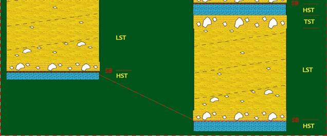
Vail et al., 1977b. AAPG 1977 reprinted with permission of the AAPG whose permission is required for further use.
 Well 5 Well 4 Well 3 Well 2 Well 1 Vail et al., 1977b AAPG 1977 reprinted with permission of the AAPG whose permission is required for further use. Well 5 Well 4 Well 3 Well 2 Well 1 Vail et al., 1977b
Convergent plate boundary.
 Crustal Deformation Convergent plate boundary http://my.execpc.com/~acmelasr/mountains/geogramsnf.html Plate Tectonic Settings and Magma Where plates CONVERGE, water is driven off the subducting plate,
PRESSURE CONDITIONS AND COAL QUALITY IN THE BLACK WARRIOR BASIN: IMPLICATIONS FOR CO 2 SEQUESTRATION
 TEMPERATURE-PRESSURE PRESSURE CONDITIONS AND COAL QUALITY IN THE BLACK WARRIOR BASIN: IMPLICATIONS FOR CO 2 SEQUESTRATION Jack C. Pashin,, Richard E. Carroll, and J. Wayne Payton GEOLOGICAL SURVEY OF ALABAMA
Chapter 6 Sedimentary and Metamorphic Rock
 Chapter 6 Sedimentary and Metamorphic Rock Weathering and Erosion Wherever rock is exposed at Earth s surface, it is continuously being broken down by weathering a set of physical and chemical processes
Ensign, Unravelling the Enigma DEVEX 2016
 Ensign, Unravelling the Enigma DEVEX 2016 Introduction Sole Pit area of UK SNS Discovered 1986, developed 2012 View and understanding evolved over time Ensign 2 The Facts Structure Fault bound 3-way dip
Overview - Minnelusa
 Overview - Minnelusa Minnelusa I Gillette, Wyo. Nick Jones, PG Sr. Geologist EORI May 6-7, 213 INFORMATION- RESOURCE Topics Part I Key Resources History of Development Pace of Discovery Minnelusa Today
The Sequence Stratigraphic and Paleogeograhic Distribution of Reservoir-Quality Dolomite, Madison Formation, Wyoming and Montana
 The Sequence Stratigraphic and Paleogeograhic Distribution of Reservoir-Quality Dolomite, Madison Formation, Wyoming and Montana TAURY SMITH AND GREGOR EBERLI The primary aim of this study is to show the
R.Suhasini., Assistant Professor Page 1
 UNIT I PHYSICAL GEOLOGY Geology in civil engineering branches of geology structure of earth and its composition weathering of rocks scale of weathering soils - landforms and processes associated with river,
John Albanese Consulting Geologist Archaeo-geology in the Powder River Basin
 Slate of Speakers WGA Field Conference 2 August 2007 Speaker Employer Tentative Talk Subject (hyperlink to abstract) Keynote speaker: Byron J. Buck McVeigh State of Wyoming Department of Administration
Technology of Production from Shale
 Technology of Production from Shale Doug Bentley, European Unconventional, Schlumberger May 29 th, 2012 Johannesburg, South Africa What are Unconventional Reservoirs Shale both Gas & Oil Coal Bed Methane
Answers: Internal Processes and Structures (Isostasy)
") Answers: Internal Processes and Structures (Isostasy) 1. Analyse the adjustment of the crust to changes in loads associated with volcanism, mountain building, erosion, and glaciation by using the concept
Answers: Internal Processes and Structures (Isostasy) 1. Analyse the adjustment of the crust to changes in loads associated with volcanism, mountain building, erosion, and glaciation by using the concept
region includes nine states and four provinces, covering over 1.4 million square miles. The PCOR Partnership
 Overview of Phase II PCOR Partnership MVA Activities IEAGHG Monitoring Network Meeting Natchez, MS May 6-8, 2010 Steven A. Smith, Energy & Environmental Research Center The Plains CO 2 Reduction (PCOR)
CRUSTAL DEFORMATION. Chapter 10
 CRUSTAL DEFORMATION and dgeologic Structures t Chapter 10 Deformation Df Deformation involves: Stress the amount of force applied to a given area. Types of Stress: Confining Stress stress applied equally
Simulation of Naturally Fractured Reservoirs with Dual Porosity Models
 Simulation of Naturally Fractured Reservoirs ith Dual Porosity Models Pallav Sarma Prof. Khalid Aziz Stanford University SUPRI-HW Motivations! NFRs represent at least 0%of orld reserves, but difficult
WESTCARB Phase I Results Review
 WESTCARB Phase I Results Review Arizona Geologic Characterization Errol Montgomery Principal Errol L. Montgomery & Associates (520) 881-4912 emontgomery@elmontgomery.com November 9, 2005 Site Characterization
Rocks. George E. King Engineering GEKEngineering.com 3/14/2009 1
 Rocks Igneous rocks result from cooling and crystallization of magma (molten lava). No hydrocarbon storage potential unless it has been modified to create porosity. No organic generation within the rock
The data presented in this graph are provisional and are intended to provide an estimate of Libby Dam forebay elevation (Lake Koocanusa).
.") Elevation (ft) 2470 2460 2450 2440 2430 2420 2410 2400 2390 2380 2370 2360 2350 2340 2330 2320 2310 2300 2290 Lake Koocanusa Elevation - Probability Chart 2280 2270 The data presented in this graph are
Elevation (ft) 2470 2460 2450 2440 2430 2420 2410 2400 2390 2380 2370 2360 2350 2340 2330 2320 2310 2300 2290 Lake Koocanusa Elevation - Probability Chart 2280 2270 The data presented in this graph are
Cuyama Basin North Fork Vineyard
 Cuyama Basin North Fork Vineyard Company Background plus Data Insights to Support GSP Development for the Cuyama Basin Presented by Grapevine Capital Partners and Cleath-Harris Geologists April 26th, 2018
Elevation (ft) 50th to 75th Percentile 25th to 50th Percentile Median Observed
 50th to 75th Percentile 25th to 50th Percentile Median Observed") 2470 Lake Koocanusa Elevation - Probability Chart Elevation (ft) 2460 2450 2440 2430 2420 2410 2400 2390 2380 2370 2360 2350 2340 2330 2320 2310 2300 The data presented in this graph are provisional and
2470 Lake Koocanusa Elevation - Probability Chart Elevation (ft) 2460 2450 2440 2430 2420 2410 2400 2390 2380 2370 2360 2350 2340 2330 2320 2310 2300 The data presented in this graph are provisional and
Geomechanics for reservoir and beyond Examples of faults impact on fluid migration. Laurent Langhi Team Leader August 2014
 Geomechanics for reservoir and beyond Examples of faults impact on fluid migration Laurent Langhi Team Leader August 2014 Reservoir Geomechanics It is critical to understand the mechanical behaviour of
Ministry of Oil and Minerals Petroleum Exploration & Production Authority BLOCK 80 (WADI SARR)
") Ministry of Oil and Minerals Petroleum Exploration & Production Authority BLOCK 80 (WADI SARR) The Wadi Sarr Block (80) occupies an area of 1961 km 2 on the Sayun- Masilah Basin in the central Yemen. Block
Ministry of Oil and Minerals Petroleum Exploration & Production Authority BLOCK 80 (WADI SARR) The Wadi Sarr Block (80) occupies an area of 1961 km 2 on the Sayun- Masilah Basin in the central Yemen. Block
Memorabilia of the Uranium Boom of the 1950 s*
 Memorabilia of the Uranium Boom of the 1950 s* Mark Wood 1 Search and Discovery Article #70125 (2012)** Posted October 8, 2012 *Adapted from oral presentation given at AAPG Rocky Mountain Section meeting,
Assessing the Effect of Realistic Reservoir Features on the Performance of Sedimentary Geothermal Systems
 GRC Transactions, Vol. 39, 205 Assessing the Effect of Realistic Reservoir Features on the Performance of Sedimentary Geothermal Systems Luis E. Zerpa, JaeKyoung Cho, and Chad Augustine 2 Colorado School
FINAL EXAM Crustal Deformation CONVERGE DIVERGENT PLATES MANTLE PLUMES FLUX BASALTIC GRANITIC
 Crustal Deformation Reading: Chapter 10 Pages 283-294 FINAL EXAM 8 to 10 AM, THURSDAY DEC. 6 HERE: Natural Science 101 BRING A SCAN TRON TURN IN YOUR REVIEW QUESTIONS BEFORE THE TEST, PICK UP WHEN YOU
Search and Discovery Article #10916 (2017)** Posted February 27, 2017
** Posted February 27, 2017") Unconventional Resource Play Potential of the Pennsylvanian Leo/Minnelusa Formations of the Powder River and Denver Basins: A Perspective via ntegrated Petroleum Systems Analysis* Michael Cheng 1, Tony
Unconventional Resource Play Potential of the Pennsylvanian Leo/Minnelusa Formations of the Powder River and Denver Basins: A Perspective via ntegrated Petroleum Systems Analysis* Michael Cheng 1, Tony
The SPE Foundation through member donations and a contribution from Offshore Europe
 Primary funding is provided by The SPE Foundation through member donations and a contribution from Offshore Europe The Society is grateful to those companies that allow their professionals to serve as
!'f \, w. Alan Stewart Colorado Exploration Company, Golden STRUCTURE OF THE FOOTHILLS AREA WEST OF DENVER, COLORADO. Introduction
 STRUCTURE OF THE FOOTHLLS AREA WEST OF DENVER, COLORADO w. Alan Stewart Colorado Exploration Company, Golden ntroduction i ; The dominant structural features west of Denver and along the mountain front
Reservoir Rock Properties COPYRIGHT. Sources and Seals Porosity and Permeability. This section will cover the following learning objectives:
 Learning Objectives Reservoir Rock Properties Core Sources and Seals Porosity and Permeability This section will cover the following learning objectives: Explain why petroleum fluids are found in underground
Simplified In-Situ Stress Properties in Fractured Reservoir Models. Tim Wynn AGR-TRACS
 Simplified In-Situ Stress Properties in Fractured Reservoir Models Tim Wynn AGR-TRACS Before the What and the How is Why Potential decrease in fault seal capacity Potential increase in natural fracture
Permeability Estimates & Saturation Height Functions: A talk of two halves. Dr Joanne Tudge LPS Petrophysics 101 Seminar 17 th March 2016
 Permeability Estimates & Saturation Height Functions: A talk of two halves Dr Joanne Tudge LPS Petrophysics 101 Seminar 17 th March 2016 Permeability: What is it? How do we measure it? Why do we need it?
Risking CO 2 leakage along faults what do we know?
 TCCS talk, 14.06.2017 Risking CO 2 leakage along faults what do we know? Alvar Braathen, Elin Skurtveit, Kei Ogata, Kim Senger and Jan Tveranger, and with contributions from Gabrielsen, Olaussen, Osmundsen,
Groundwater. (x 1000 km 3 /y) Reservoirs. Oceans Cover >70% of Surface. Groundwater and the. Hydrologic Cycle
 Reservoirs. Oceans Cover >70% of Surface. Groundwater and the. Hydrologic Cycle") Chapter 13 Oceans Cover >70% of Surface Groundwater and the Hydrologic Cycle Oceans are only 0.025% of Mass Groundwater Groundwater is liquid water that lies in the subsurface in fractures in rocks and
Chapter 13 Oceans Cover >70% of Surface Groundwater and the Hydrologic Cycle Oceans are only 0.025% of Mass Groundwater Groundwater is liquid water that lies in the subsurface in fractures in rocks and
The Influence of Shear and Deviatoric Stress on the Evolution of Permeability in Fractured Novaculite and Diorite
 Igor Faoro, Andre Niemeijer, Chris Marone, Derek Elsworth The Influence of Shear and Deviatoric Stress on the Evolution of Permeability in Fractured Novaculite and Diorite Department of Energy and Geo-Environmental
Horizontal Injectors & Producers at SACROC Clyde Findlay II & Jeremy Pitts
 1 Horizontal Injectors & Producers at SACROC Clyde Findlay II & Jeremy Pitts Presented at the CO 2 & ROZ Conference. Dec 6, 2018 SACROC 2 SACROC phih Map 1948 - discovered in Scurry County, Texas 52,000
CHAPTER III. METHODOLOGY
 CHAPTER III. METHODOLOGY III.1. REASONING METHODOLOGY Analytical reasoning method which used in this study are: Deductive accumulative method: Reservoir connectivity can be evaluated from geological, geophysical
GEOL 3700 STRUCTURE AND TECTONICS LABORATORY EXERCISE 3
 GEOL 3700 STRUCTURE AND TECTONICS LABORATORY EXERCISE 3 Goals: 1. Improve your map-reading and map-making skills. 2. Learn to generate and interpret structure contour maps. 3. Learn to generate and interpret
Steve Cumella 1. Search and Discovery Article # (2009) Posted July 30, Abstract
 Posted July 30, Abstract") AV Geology of the Piceance Basin Mesaverde Gas Accumulation* Steve Cumella 1 Search and Discovery Article #110106 (2009) Posted July 30, 2009 *Adapted from oral presentation at AAPG Annual Convention,
AV Geology of the Piceance Basin Mesaverde Gas Accumulation* Steve Cumella 1 Search and Discovery Article #110106 (2009) Posted July 30, 2009 *Adapted from oral presentation at AAPG Annual Convention,
CE6301 ENGINEERING GEOLOGY UNIT I 2 MARKS
 YEAR : II SEMESTER : III DEPARTMENT : CIVIL CE6301 ENGINEERING GEOLOGY UNIT I 1. What is Physical weathering? 2. Define Stratigraphy and Palaeontology? 3. What is meant by chemical weathering 4. Describe
Subsurface Maps. K. W. Weissenburger. Isopach. Isochore. Conoco, Inc. Ponca City, Oklahoma, U.S.A.
 Subsurface Maps K. W. Weissenburger Conoco, Inc. Ponca City, Oklahoma, U.S.A. INTRODUCTION Reservoir properties are mapped to promote optimal field development. Subsurface maps dictate well placement and
Salt invasion in a Triassic reservoir. A case study from the Southern North Sea
 Salt invasion in a Triassic reservoir A case study from the Southern North Sea Agenda Regional setting Triassic gas play Statistical investigation Seismic attribute analysis Conclusions & further study
Soils, Hydrogeology, and Aquifer Properties. Philip B. Bedient 2006 Rice University
 Soils, Hydrogeology, and Aquifer Properties Philip B. Bedient 2006 Rice University Charbeneau, 2000. Basin Hydrologic Cycle Global Water Supply Distribution 3% of earth s water is fresh - 97% oceans 1%
Multiphase flow modeling challenges for monitoring of hydrocarbon reservoirs and CO 2 sequestration targets: multiphase
 P-526 Summary Multiphase flow modeling challenges for monitoring of hydrocarbon reservoirs and CO 2 sequestration targets: multiphase Vladimir Alvarado* and Hamid Behzadi, Department of Chemical and Petroleum
Exploration / Appraisal of Shales. Petrophysics Technical Manager Unconventional Resources
 Exploration / Appraisal of Shales Rick Lewis Petrophysics Technical Manager Unconventional Resources Organic Shale Factors Controlling Gas Reservoir Quality Conventional sandstone Mineral framework Gas
Elevation (ft) 50th to 75th Percentile 25th to 50th Percentile Median Observed /1 11/1 12/1 1/1 2/1 3/1 4/1 5/1 6/1 7/1 8/1 9/1 Date
 50th to 75th Percentile 25th to 50th Percentile Median Observed /1 11/1 12/1 1/1 2/1 3/1 4/1 5/1 6/1 7/1 8/1 9/1 Date") Elevation (ft) 2470 2460 2450 2440 2430 2420 2410 2400 2390 2380 2370 2360 2350 2340 2330 2320 2310 2300 2290 2280 2270 2260 2250 2240 2230 2220 Bars Indicate 5th and 95th percentiles Lake Koocanusa Elevation
Elevation (ft) 2470 2460 2450 2440 2430 2420 2410 2400 2390 2380 2370 2360 2350 2340 2330 2320 2310 2300 2290 2280 2270 2260 2250 2240 2230 2220 Bars Indicate 5th and 95th percentiles Lake Koocanusa Elevation
Subsurface to Surface Correlation of the Tensleep Sandstone in the West Flank of the Pryor Mountains in Carbon County, Montana
 Montana Tech Library Digital Commons @ Montana Tech Graduate Theses & Non-Theses Student Scholarship 5-2014 Subsurface to Surface Correlation of the Tensleep Sandstone in the West Flank of the Pryor Mountains
Pressure Transient Analysis COPYRIGHT. Introduction to Pressure Transient Analysis. This section will cover the following learning objectives:
 Pressure Transient Analysis Core Introduction to Pressure Transient Analysis This section will cover the following learning objectives: Describe pressure transient analysis (PTA) and explain its objectives
SECARB Phase III ANTHROPOGENIC TEST: Risk Management through Detailed Geologic Characterization and Modeling
 SECARB Phase III ANTHROPOGENIC TEST: Risk Management through Detailed Geologic Characterization and Modeling Prepared by: David Riestenberg, George Koperna, and Vello Kuuskraa, Advanced Resources International,
Gravel Transport Can Determine Late Flood Tectonics
 Chapter 23 Gravel Transport Can Determine Late Flood Tectonics The locations of all the quartzite gravel in the northwest states and adjacent Canada provide more information about the Flood than just reinforcing
CO 2 storage capacity and injectivity analysis through the integrated reservoir modelling
 CO 2 storage capacity and injectivity analysis through the integrated reservoir modelling Dr. Liuqi Wang Geoscience Australia CO 2 Geological Storage and Technology Training School of CAGS Beijing, P.
Fault Rocks. EARS5136 slide 1
 Fault Rocks EARS5136 slide 1 Fault rocks Fault rock types Examples of deformation features in cores Microstructures Porosity and permeability Lithological and lithification control EARS5136 slide 2 Deformation
THE INVESTIGATION OF NUMERICAL SIMULATION SOFTWARE FOR FRACTURED RESERVOIRS
 INTERNATIONAL JOURNAL OF NUMERICAL ANALYSIS AND MODELING Volume 2, Supp, Pages 161 168 c 2005 Institute for Scientific Computing and Information THE INVESTIGATION OF NUMERICAL SIMULATION SOFTWARE FOR FRACTURED
GEO 303. Introduction to Geology LAB FINAL EXAM
 Name Lab section: Day Hour TA GEO 303 Introduction to Geology LAB FINAL EXAM Spring, 1999 100 points 2 INSTRUCTION: This multiple-choice, machine-graded exam consists of 100 questions, each worth 1 point.