Coastal Mining and its Influence on Coastline Stability
|
|
|
- Horatio Perry
- 6 years ago
- Views:
Transcription

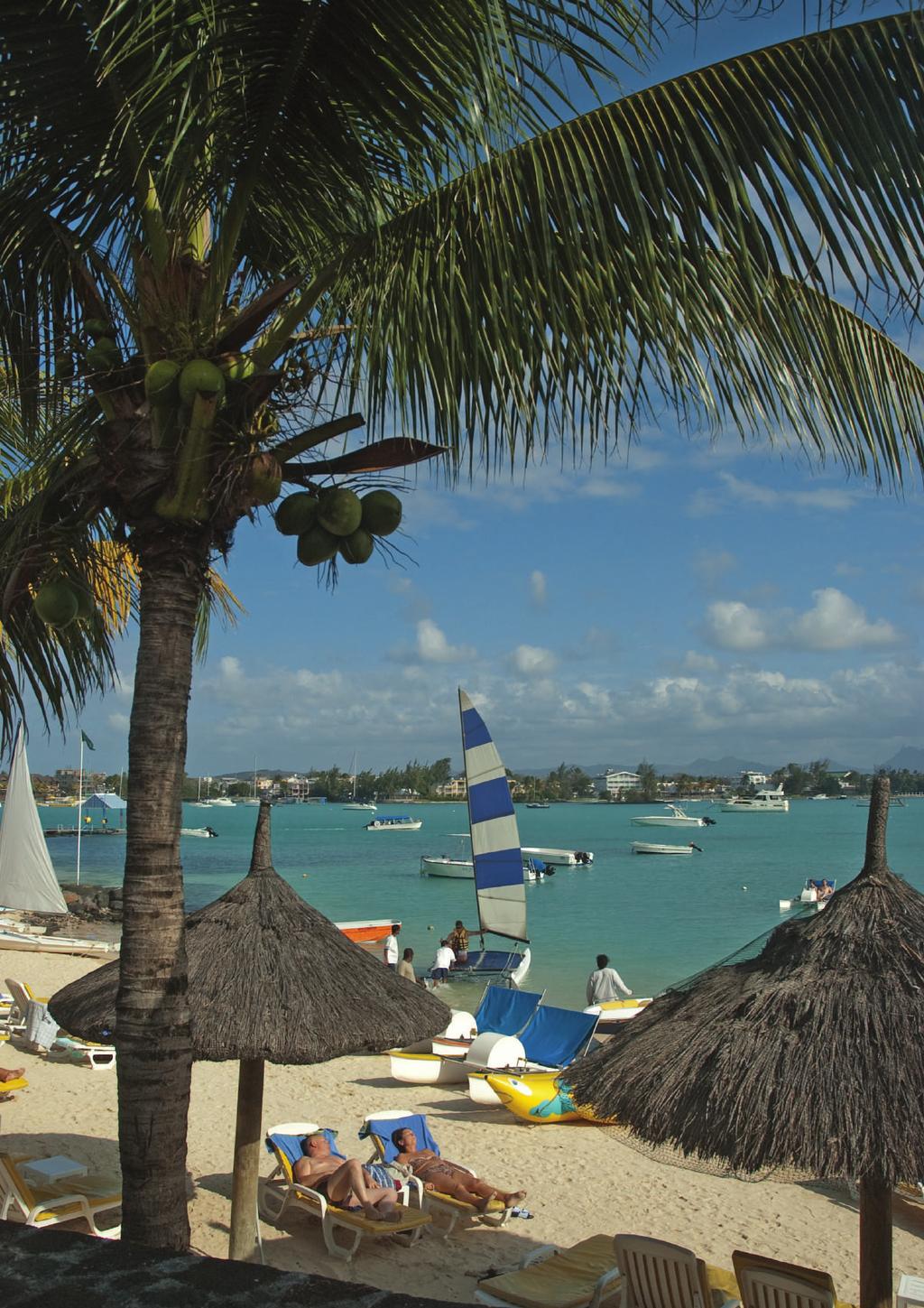
1 27 Coastal Mining and its Influence on Coastline Stability Laurie Barwell Opposite page: Artisanal sand mining near Mombasa, Kenya. Laurie Barwell. Introduction In UNEP/ Nairobi Convention Secretariat (2009) it is reported that the coastal regions of Sub-Saharan Africa are generally endowed with non-renewable mineral resources such as pyrochlore, gypsum, barites, iron ore, clay, apetite, galena, manganese and semi-precious stones. These occur where geological processes have contributed to concentrating certain deposits with examples being the rich diamond fields off the southern African west coast and the titaniumrich dune fields and sandy shores of various parts of East Africa including Madagascar. It is further reported in UNEP/ Nairobi Convention Secretariat (2009) that the geological exploration of the WIO region is far from comprehensive so that unknown deposits are likely to exist. In cases where mining for minerals is indeed undertaken, there are reported examples of major environmental changes. As denoted in UNEP/ Nairobi Convention Secretariat (2009) the central drivers of the economy of the coastal areas and the countries of the WIO, in general, include maritime trade, tourism, fisheries, agriculture, mining and other industries and a large percentage of the GDP (see Chapter 1) of the WIO region is generated within the immediate vicinity of coastal towns and cities. The local, national and regional economy is often associated with the infrastructure required by tourism and the ports that form the trade links to international markets. ence on natural resources, including the basic components of building material, namely cement, sand and coarse aggregate (stones) for concrete and mortar, and clay for bricks (ASCLME 2012a i). Dune fields and beaches located closer to river deltas consist of quartz sand and may contain other minerals, more frequently heavy minerals. In other areas, many of the beaches are composed of shell and coral fragments that are of organic origin and are known as carbonaceous sands. DHI and Samaki (2014) report that both live coral rock in shallow waters and onshore fossil coral limestone occur along large stretches of the WIO coastline and are seen as a useful source of building material where the larger boulders sizes are used as building bricks / stones and when broken, can be mixed into concrete as stones and sand. The traditional practice of baking coral rock and crushing the residue to be used as cement is also widely practiced in areas in the WIO region especially in the southern Tanzania coastal region as reported on in DHI and Samaki (2014). Collectively, the sand and coarse aggregate (stones) material is known as aggregates and further categorized as fine aggregates (grains smaller than 1 cm) and coarse aggregates when larger. The availability of such aggregates along the coast is often seen as a free resource along with the demand from the construction industry offer opportunities for entrepreneurs in both the formal and informal sectors along the whole supply chain (Pikey undated). This is Infrastructural development results in heavy depend- especially noticeable in the Small Island Developing We s te r n I n d ia n O ce a n FinalRESOCR.indd /09/16 13:10
2 VI. Assessment of other human activities and the marine environment States (SIDS) where, even though sand and limestone deposits exist, there are inherent challenges in formally sourcing building materials for the building industry (UNEP/ Nairobi Convention Secretariat 2009). Sediment washed down rivers during floods is deposited within the coastal system and thereby contributes to the coast s natural ability to buffer against sea surges and erosion during storms. In untransformed systems, accretion processes balance the coastal erosional processes and the coastline exists in a state of dynamic equilibrium (Tinley 1985). Transformational pressures in the form of overexploitation, modification and loss of habitats and uncontrolled development or encroachment onto the dynamic beach and coastal system have resulted in environmental degradation including a reduction of the natural dampening effect against sea surges during storms that coral reefs, beaches and dunes have (Roger 2002). The total sum of these factors has a negative impact on coastal communities and often on the countries at large (Masalu 2002). Some of these impacts include catchment degradation due to poor land-use practices including agriculture and uncontrolled mining activities such as sand excavation from rivers and the destruction of riverine habitat for solar salt production (DHI and Samaki 2014). This can result in increased sediment and silt load in rivers, causing coastal accretion and in places the smothering of habitats such as coral reefs UNEP/ Nairobi Convention Secretariat (2009). The die-off of coral results in a reduction of the protection that such reefs offer to the adjacent coastline against the forces of the sea. On the other hand, coastal erosion has occurred in places due to the coastal system being starved of its sources of sand. This is often due to anthropogenic activities. Such activities include the construction of dams in river courses (which trap sediments); aggregate mining in rivers and from foredunes, beaches and the shoreface; and the sterilisation of the littoral sand source located in dune cliffs and foredunes due to development encroachment (Tinley 1985). In many cases, the construction of harbour infrastructure including breakwaters and/or the dredging of shipping entrance channels has interrupted, reduced or totally changed the natural alongshore sand transport system (USACE 1984). Natural and human derived driving forces Since it is implied that coastal mining may have a contributory effect on the stability of the coastline as observed in the form of either coastal erosion or accretion in places (UNESCO 2000, Government of Kenya 2009, ASCLME 2012a i, DHI and Samaki 2014), this chapter focuses on coastal mining within the context of the physical (abiotic) part of the coastal system. In particular, the influence of coastal mining on the coastal sand system, as an anthropogenic driving force, is assessed as a proxy of the state of the coast in this context. Note that the biotic, economic and societal components of the coupled coastal system are described in other sections of this book. The types of coastal mining activities in the WIO countries considered in the context of the chapter are: Quarrying of coral rock and limestone for cement manufacturing and course aggregates for concrete and road building; Artisanal sand mining from the catchment, floodplains, river banks, estuaries and lagoons; Informal removal of sand from beaches and foredunes; Formal mining of minerals from titaniferous sands; and, The production of sea salt from saltpans typically located on estuary flood plains (ASCLME 2012a i, DHI and Samaki 2014). The coastline erosion and accretion can result in significant shoreline change (UNEP/ Nairobi Convention Secretariat 2009). Even though coastal erosional trends can be part of the normal coastal processes, the observed erosional trend in parts of the WIO countries is thought to be as a result of anthropogenic activities, as well as episodic storms (which are in part thought to be driven by climate change). The resultant impact on critical habitats, coastal infrastructure, agricultural land and human settlements have been shown to be significant in places, with the impact being accentuated where the shoreline is characteristically low lying and highly erodible such as where dune cliffs and sandy beaches occur. A comprehensive study in Mozambique has confirmed the vulnerability of low lying and erodible coastlines to the effect of episodic storms under existing and future projected climate scenarios (Theron and others, 2012). DHI and Samaki (2014) report that, in Tanzania, coastal mining at community level is mainly focused on sand and gravel mining, salt production and coral mining. They further report that sand and stone quarrying along beaches, coastal water- courses and other areas are considered important livelihood activities to a point that infor- 352 Regional State of the Coast Report
3 27. Coastal mining and its influence on coastline stability mal (un-regulated) sand mining has become a big local industry. As confirmed in research undertaken by Masalu (2002), these informal activities create a range of jobs and local income with resultant socio-economic opportunities and challenges. However the activities can, and often do, result in localised accelerated and / or severe coastal erosion, extensive environmental degradation and an increase in the risk from the forces from the sea on coastal properties which in turn can lead to decreased economic activities, job losses and extensive long-term costs to the local economy. Changes in accretion to the coast occur as a result of either a change in sediment loads from rivers and estuaries, due to poor land-use and management practices; changes in nearshore processes (such as engineering structures) and/or the re-suspension of sediments in the nearshore by rough seas, often associated with cyclonic conditions (Tinley 1985). As shown in Box 27.1 the natural driving forces that influence the stability of the coastline are: (1) alongshore sand transport; (2) cross-shore sand transport; (3) wind-blown sand transport; and, (4) river flow transporting sediment and silt. The underlying condition is the existence of suitable sand supplies. A further consideration is the effect of future climate change on the wind regime and the sea level. Human actions directly influence the stability of the coastline As depicted in Box 27.1, all the sand sources and sinks are linked to one another and thereby form a coastal sand system that is in a natural state of ever-changing equilibrium (USACE 1984). This implies that if a removal from or addition of sand to a system component occurs, it affects all of the other parts of the system and a new equilibrium is formed. Anthropogenic actions, defined as Pressures (in the DPSIR framework), are shown as A to E in Box 27.1 and can influence the stability of the coastline in the short-, medium- and long-term. In this chapter the state of the coast and the impact and significance of coastal mining activities on the shortand long-term shoreline dynamics are assessed in the context of the coastal sand system as it exists in the WIO coastal belt. This area has large stretches where sediment (sand) occurs along coastal shorelines where it exists in dynamic equilibrium with wave, current and wind-driven processes to form the coastal sand system (USACE 1984, USACE 2004), as depicted in Box Criteria for assessing the state and level of impact on the integrity of the coastal sand system Building onto the assessment approach followed by Theron and others (2012), in Mozambique, and responding to the typical DPSIR framework (Kristensen 2004) as applied in the context of coastal mining activities in the WIO region, an assessment framework for reflecting the state and level of the residual impact on the integrity of the coastal sand system due to coastal mining is here defined and depicted in Table The focus of the assessment is on the residual impact of coastal mining on the integrity of the coastal sand system as a regulating ecosystem service and an integral component of the social-ecological system that prevails within the coastal belt of WIO countries. Seven key elements of the complex system were crystallized from the work reported by Masalu (2002) and the Box 27.1, and are shown in Table 27.1, where the associated criteria for assessing the residual impact are also shown. The qualitative rating and associated numeric score are included. Assessment of the state of the coastline Although the National Marine Ecosystem Diagnostic Analysis (NMEDA) series of country specific reports prepared by the UNDP (ASCLME 2012a i) include basic summaries of the available information on mining activities in the WIO countries under consideration, very little quantitative data are available on coastal mining. This necessitated the use of a similar method to the tried-andtested assessment approach followed in Mozambique where a qualitative approach was employed for the assessment of the risk and vulnerability to climate change in data- and information-poor contexts (Theron and others, 2012). The qualitative assessment method, as adapted from the Theron and others (2012) approach, consisted of the following steps: No field research, site visits or new data gathering activities were carried out; As evidence on which the assessment is based, recent country specific literature (scientific, consultancy and management papers, books and reports) was sourced using the Internet. For the WIO countries the most useful was found to be the ASCLME series published by UNDP (ASCLME 2012a i). It was impossible to limit the literature to only peer-reviewed work as this would have made no sense given the lack of this qualitative research work; Western Indian Ocean 353

4 VI. Assessment of other human activities and the marine environment BOX A typical coastal sand system Flood plain River Channel Estuary Basin Vegetated Managed Partially or Unvegetated Foredunes Estuary/river mouth Beaches and shoreface Hard rock Barriers reefs Erodible rock Hard rock Sand dunes Cliffs Coral scarps Coral Catchment Limestone Elements of the typical coastal sand system and the main natural mechanisms and anthropogenic activities that cause sand to be moved within the system (adapted from Tinley 1985) Key: A, 1 & 2: Sand is fed into the littoral zone when high seas erode coastal dune cliffs and then moved alongshore and cross-shore by nearshore currents. Another source of sand arises through the continuous abrasion of boulders and pebbles through wave action impacting on erodible rocky cliffs, reefs and pebble beaches. A, 2 & 3: Where onshore winds dominate, sand is blown off the beach and foredunes into dunefields. In places, it is moved beyond the reach of storm-waves into the area landwards of the primary dune system, hence it is removed from the coastal sand system. Figure 27.1 illustrates this typical transversal profile of a naturally developing sandy coast. The sand stored in the beach and foredune areas provide a natural buffer against the forces of the sea whereas the sand in the central dune area is important as a reserve under future sea level rise scenarios. Where the geomorphology is suitable, sand from these dune fields bypasses a headland to, in time, join the littoral system either directly into an adjacent bay or into a river. In places, a portion of the sand budget is drained from the shoreface into submarine canyons and thereby removed from sand system. B, 1 & 2: Coral reefs grow under suitable conditions and coral sand is formed when corals die-off or are broken by wave action thereby forming a source of sand to adjacent beaches. The coral sand is moved across-shore and alongshore. In the nearshore area (seaward of the barrier reefs when present) the sand typically forms a shoreface stretching from the beach (or reef) to about 10 m water depth. Sand in the nearshore area is reworked by waves, currents and wind to form connected environments such as beaches and foredunes. At accreting shorelines, the foredunes mature (through the ongoing establishment of a succession of vegetation) and in time form central and backdune areas that show little change. Where the coastline is in an eroding state, the foredune forms a steep scarp with little or no hummock dune zone. D, 4: Alluvial (mainly siliceous) sand originating in river catchments is washed downstream during river floods to be deposited in river and tidal deltas at the coast. 354 Regional State of the Coast Report

5 27. Coastal mining and its influence on coastline stability Each document was subjected to keyword-based searches using each of the five identified coastal mining activities as keywords; The search results were rated in terms of the published content and significance of data and/or information. The ratings were thus derived for the seven elements and associated state / impact descriptors listed in Table 27.1; In many cases there is a lack of information in the published documentation and the specific cells in the tables are consequently shown blank; A qualitative rating / score was determined against the scale depicting the state of impact ranging from Very Low (VL) to Very High (VH) with associated scores of 1 to 5 to allow for a comparative analysis across countries and for mining activity type; and, The scores are reflected in Tables 27.2 to 27.7 and a normalized score (given out of a maximum of 5) was calculated for each element. This allows comparative deductions to be carried out across the countries, mining activities and mining activities. Ideally, given the data-poor environment, the rating criteria and descriptors depicted in Table 27.1 should be defined and the rating (Step 4) achieved by consensus within a panel of experts representing the various components of the coastal socio-ecological system assessment as well as the various mining activities. Furthermore, the rating / score should be agreed to after observing the actual activities on site. FOREDUNES I II STRAND PLANT ZONE SHRUB ZONE III SCRUB-THICKET ZONE IV THICKET / FOREST ZONE or HEATH-THICKET MOSAIC INSHORE SURF ZONE FORESHORE drift line beach ridge or berm BACKSHORE A B C D E YOUNGEST FIXED DUNE YOUNGEST FIXED TROUGH F G s e a f a c i n g CENTRAL DUNE aspects l a n d f a c i n g oldest fixed dune BACK DUNE SHORE & DUNEFORM SEQUENCE Primary Dunes LITORAL HUMMOCK DUNE ZONE EPHEMERAL DUNE EMBRYO SHORE DUNES CREEPER ZONE DRIFTLINE HUMMOCK DUNES COPPICE DUNES BACKSHORE DUNES FRONTAL DUNES FRONT, INNER, SEAWARD Secondary Dunes REAR, HIND, OTER, POSTERIOR, LANDWARD DUNE ZONATION ON MOISTER COASTS (Above 200mm rainfall) complete sequence MULTIPLE FIELD DUNE SYSTEM G A B C D D E F Figure Typical transversal profile of a developing sandy coast showing geomorphological units and the different terminology used to characterize the coastal zone. (adapted from Tinley 1985 in Barwell 2011). Photo A. Theron. Western Indian Ocean 355
6 VI. Assessment of other human activities and the marine environment Table Criteria for assessing the impact of drivers and pressures on the coastal social-ecological system. # Element Scale of mining activities in the context of the coastal sand system Sustainable growth potential of the mining activity Societal benefit potential (jobs) of the mining activity Economic benefits of the mining activity Mining activity on the coastal sand system Criteria for assessing residual impact (qualitative assessment based on interpretation of available literature) Rating: VL L M H VH Score 1 : Remotely if at all Indirectly and controlled Indirectly and uncontrolled Directly and controlled Insignificant Low Medium High Significant / far reaching job gains Significant / far reaching Insignificant Direct job gains Neutral Direct job losses Direct benefit Indirectly and controlled Neutral Indirectly and uncontrolled Direct cost to economy Directly and controlled Directly and uncontrolled Very high Indirect job losses / far reaching Indirect cost to economy Directly and uncontrolled 6 Policy governing the mining activity Explicit Adequate General Non explicit Not clear / lacking 7 Level of capability to control the mining activity Mature Competent Growing Embryonic Lacking Note 1: The score of 1 is associated with a residual impact rating of VL (Very Low) scaling up to a score of 5 for a residual impact rating of VH (Very High). Assessment results The assessment results for the identified types of coastal mining activities in each country (as reflected in available literature) are depicted in Tables 27.2 to Table 27.7 shows the overall residual state and impact of the collective coastal mining activities on the coastal social-ecological system of each of the countries as well as the overall score (normalised). Referring to the assessment criteria in Table 27.1, Table 27.2 depicts the residual impact of the current scale of coral rock and limestone quarrying. It can be seen that the scale of impact of such mining by the formal sector is considered to be remotely if at all (score 1 Table 27.1). No information is available on informal quarrying although mention is made of some community based activities in Somalia resulting in an impact rating of directly and uncontrolled (score 5). Note that the scale of impact on the biotic system (for example important habitats and/or specific species) may be significant but this is not considered in this assessment as the focus is on the abiotic components of the coastal sand system. From the literature it is determined that there is a high growth potential (score 4) for formal mining in the countries assessed. This is mainly due to the under-utilization of known resources. The sustainable growth potential for informal quarrying is considered to be insignificant (score 1) in Kenya, Mozambique and Tanzania (mainly due to the associated expense as well as the existence of good policies. Since natural resources are underexploited in Somalia there is a very high growth potential (score 4) in the formal sector. Due to the unstable situation in Somalia, the potential for uncontrolled growth in the informal activities is very high (score 5) if market demand exists. This results in a direct benefit (score 2) rating for the economy at a local level but neutral (score 3) on a national and regional scale. In Table 27.3 it can be seen that the residual impact of the current scale of terrestrial and river sand quarrying in the formal sectors is considered to be indirectly and controlled (score 2). The artisanal component (informal sector) is rated as indirectly and uncontrolled (score 3). The literature review suggests that there is a high potential (score 4) for sustainable growth in both the formal and informal sectors in the countries where information is available. In Somalia the potential is low (score 2) due to the current limited demand and lack of infrastructure. Since natural resources are under-exploited in Somalia there is a very high (score 5) growth potential in the formal sector and due to the unstable situation the potential for uncontrolled growth in the informal activities is very high (score 5) if local market demand exists. This results in a direct benefit (score 2) at a local level but neutral (score 3) at the national and regional scales. The residual impact of the current scale of beach sand mining is shown in Table 27.4 as being remotely if at all 356 Regional State of the Coast Report
. Table 27.4. Beach sand (including sand from foredunes). (score 1) for the formal sector.")
 for formal and informal beach and foredune sand mining in the countries where information is available.")

7 27. Coastal mining and its influence on coastline stability Table Coral and limestone quarrying for cement manufacturing and aggregates. Table Terrestrial and river sand quarrying (including from hills, river banks, estuaries and floodplains). Table Beach sand (including sand from foredunes). (score 1) for the formal sector. The scale of current beach sand mining by the informal sector is considered to be direct and uncontrolled (score 4) in the countries where information is available. From the literature reviewed, there is an insignificant growth potential (score 1) for formal and informal beach and foredune sand mining in the countries where information is available. This is thought to be due to a resource constraint prevalent at coastal cities where there may be a market demand. In places, it is difficult for artisanal miners to gain access to the beach and foredunes because of the existing development on the beachfront. In many countries, restricting this activity is seen as a priority and available policies are implemented and policed. The exception appears to be Somalia where there appears to be a high to very high growth potential due to the current underutilization of known resources and uncertainty about the existence of suitable policy and a lack of controlling capability. Although there is a lack of beach and foredune sand in many of the coastal cities in Mozambique where the effects of coastal erosion are noticeable, the potential to utilize the extensive sand deltas at major river mouths does exist thus attracting a score of 4 (high). Many of the sandy parts of the shoreline within the WIO region are utilized for tourism with many resorts located adjacent to sandy beaches. These resorts offer Western Indian Ocean 357
8 VI. Assessment of other human activities and the marine environment many direct and indirect job opportunities. Often the resort infrastructure is located directly on the foredune and thereby reduces the storm buffering potential of the foredunes. The depletion of beach sand due to mining has a large potential impact on the local economy through direct job losses (score 4) and far reaching job losses (score 5) at a national scale. Regionally the impact is neutral (score 3). The assessment of the specific residual impact of beach and foredune sand mining activities on the various components of the coastal sand system (Figure 27.1) shows a rating of direct and uncontrolled (score 5) due to the scarcity of beach sand resource in most of the WIO countries. The only exception is Somalia where the impact is assessed to be indirect and uncontrolled (score 3) due to a lack of market demand. Removal of beach and foredune sand has an insignificant impact on the regional coastal sand system. Table 27.5 summarizes the residual impact of the mining activities related to extracting minerals from titaniferous sand dunes. Being a formalized activity under strict control, the scale is scored at 2 (indirect impact and controlled). No information could be found on informal activities. Available geological information indicates a high growth potential (score 4) for the formal sector with an insignificant (score 1) potential for the informal sector due to the highly specialized nature of mineral extraction and post-mining management. Job creation potential is rated as being significant and far reaching at a local level thus scoring a 1 and neutral (score 3) at a national level. A strong positive residual impact on the local economy is indicated through a direct benefit (score 2) rating. With mining activities typically located a distance inland from the shoreline and well controlled through monitored environmental management plans, the impact on the coastal sand system is considered to be indirect and controlled (score 2). Table 27.6 shows the residual impact of salt works development typically on estuary floodplains where natural mangrove stands are typically removed to create large expanses of saltwater pans where salt is formed during the evaporation of seawater in the pans under controlled conditions. Being a formalized activity under strict control, the scale is scored at 2 (indirect impact and controlled). No information could be found on informal activities but the impact from informal solar salt works are rated as being indirect and uncontrolled (score 3). In many of the WIO countries a large number of estuary floodplains exist where the sustainable growth potential for both formal and informal salt extraction activities is rated as medium (score 3). Note that the scale of impact on the biotic system (for example important habitats and/or specific species) may be a lot more and this is not considered in this chapter. In Table 27.7 it can be seen that the overall residual impact of the current scale of coastal mining within the context of the coastal sand system from both the formal as well as the informal sectors is considered to be remotely if at all (Table 27.1). The literature suggests that there is a medium to high growth potential for formal mining in various countries. This is mainly due to the under-utilization of known resources. High scores reflect the opportunity for economic growth due to the controlled formalization of mineral extraction from titanerifous dune sands, formal quarrying of limestone and coral rock (for cement and coarse aggregate) as well as sand from identifiable areas within the coastal belt. The societal benefit is reflected in terms of the potential for job creation since the lack of formal economic opportunities was identified as one of the root causes of resource over-exploitation and environmental degradation. The results show that at a local level, coastal mining offers direct job gains as well as having significant / far reaching job gains due to the demands generated by the coastal industries and tourism. The impact at a national level is mainly deemed neutral since, even though formal coastal mining activities may be an important activity in a specific country, the impact is not more or less than the other sectors where jobs are concerned. A similar situation exists for the residual impact on the local, national and regional economy where the rating falls into a band between of direct benefit (score 2) to neutral (score 3). When examining the assessment of the specific residual impact of coastal mining activities on the various components of the coastal sand system (see Box 27.1), it can be seen that the overall rating for the WIO region is deemed to be indirect and controlled (score 2) at a local scale and insignificant (score 1) at a regional scale. It is important to read this specific assessment score in conjunction with the assessment of the scale of the mining activities as well as considering the existence of coastal management and mining policies and the capability to implement the said policies. These are rated as being adequate (score 2) in most countries for the former and growing (score 3) for the latter. 358 Regional State of the Coast Report
. Table 27.")
, result in an assessment of the current state of the coastal sand system.")

9 27. Coastal mining and its influence on coastline stability Table Mineral-rich (titaniferous) sand dunes (for example Ilmentite, zircon, rutile). Table Solar salt works located on estuary / river floodplains (includes Mangrove removal). Table Overall residual state and impact for all coastal mining in the WIO countries Conclusion on the assessment Understanding the activities (the drivers of change) and their underlying social and economic pressures (the root causes), result in an assessment of the current state of the coastal sand system. Estimating the net effect of coastal mining activities on the coastal sand system can then lead to a qualitative conclusion on the contribution of coastal mining and the associated impact on the coastal abiotic system. Reflected as a residual impact, the overall state of the current scale of coastal mining on the abiotic coastal system from both the formal as well as the informal sectors is rated as VERY LOW for the WIO countries where information is available. Note that the scale of impact on the biotic (for example important habitats and/or specific species) and social/cultural/historic perspective may be a lot more as this is considered beyond the scope of this chapter. In some of the WIO countries, the under-utilisation of known resources leads the growth potential for formal mining to be assessed at a medium to high level. The high scores reflect the opportunity for economic growth due to the controlled formalization of mineral extraction from titanerifous dune sands, formal quarrying of limestone and coral rock (for cement and coarse aggregate) as well as sand from identifiable areas within the coastal belt. The oppor- Western Indian Ocean 359
10 VI. Assessment of other human activities and the marine environment tunity exists for current infrastructure to be used to export high quality building sand to the island countries from areas where sustainable sources exist. Response and policy considerations The following pointers can be considered for incorporating into existing policies that relate to managing of coastal mining activities in WIO countries: The available literature (for example ASCLME 2012a i) shows that explicit policies that relate to coastal mining activities do exist in most of the WIO countries under consideration. A policy of explicitly sharing good practice within the WIO region could be strengthened. The information indicates that the level of capabilities to control the mining activities fall in the mature to competent categories. A policy of active succession planning and multi-national skills development will secure a sustainable research and management capability within the WIO countries. It appears that (some) authorities are finding it challenging to implement policies especially in areas where informal mining activities prevail. A policy that guides the utilisation of a valuable natural resource should be formulated when more detailed quantifiable research is undertaken. The opportunity exists to implement actions that inform and educate the public and managers on the functioning of the coastal sand system and its importance as a natural protection against existing and future, climate change enhanced, forces from the sea. The importance and value of the coastal sand system as a regulating ecosystem service within the coastal socialecological system should be acknowledged and recognised in coastal zone management policies. For example, a coastal hazard level should be defined and coastal development (including mining activities) restricted to beyond the littoral system to ensure that the buffering services can be sustained within the projected climate change scenarios. The opportunity exists to use the sand that is left over from commercial heavy mineral mining activities in Kenya and Mozambique as a commercially exploitable natural resource for export to WIO countries where this resource is limited. A policy of ensuring the direct participation of current artisanal (informal) sand miners in the whole value chain of this venture would enhance the socioeconomic benefit across the whole WIO region at a local as well as national level whilst ensuring the integrity of the coastal sand system. References ASCLME (2012a). National Marine Ecosystem Diagnostic Analysis. Comoros. Contribution to the Agulhas and ASCLME (2012b). National Marine Ecosystem Diagnostic Analysis. Kenya. Contribution to the Agulhas and Somali Current Large Marine Ecosystems Project (supported by UNDP with GEF grant financing) ASCLME (2012c). National Marine Ecosystem Diagnostic Analysis. Madagascar. Contribution to the Agulhas and ASCLME (2012d). National Marine Ecosystem Diagnostic Analysis. Mauritius. Contribution to the Agulhas and ASCLME (2012e). National Marine Ecosystem Diagnostic Analysis. Mozambique. Contribution to the Agulhas and ASCLME (2012f). National Marine Ecosystem Diagnostic Analysis. Seychelles. Contribution to the Agulhas and ASCLME (2012g). National Marine Ecosystem Diagnostic Analysis. Somalia. Contribution to the Agulhas and ASCLME (2012h). National Marine Ecosystem Diagnostic Analysis. South Africa. Contribution to the Agulhas and ASCLME (2012i). National Marine Ecosystem Diagnostic Analysis. Tanzania. Contribution to the Agulhas and 360 Regional State of the Coast Report
11 27. Coastal mining and its influence on coastline stability Barwell, L. (2011). Integrity assessment procedure for buffer dune systems on the Cape South Coast, South Africa. MSc. Thesis Civil Engineering. University of Stellenbosch, South Africa. DHI and Samaki (2014). Coastal Profile for Mainland Tanzania 2014 Thematic Volume Draft 0. Investment Prioritization for Resilient Livelihoods and Ecosystems in Coastal Zones of Tanzania DHI and Samaki Consultants Government of Kenya (2009). State of the Coast Report: Towards Integrated Management of Coastal and Marine Resources in Kenya. National Environment Management Authority (NEMA), Nairobi Kristensen, P. (2004). The DPSIR Framework. Workshop on a comprehensive/detailed assessment of the vulnerability of water resources to environmental change in Africa using river basin approach September. UNEP Headquarters. Nairobi, Kenya Masalu, D.C.P. (2002). Coastal Erosion and Its Social and Environmental Aspects in Tanzania: A Case Study in Illegal Sand Mining. Coast. Manage. 30 (4), Roger, H.C. (2002). Impact on the Coastal Environment of Marine Aggregates Mining. Int. J. Environ. Stud. 59(3), Theron, A.K. and Barwell, L.B. (2012). Responding to Climate Change in Mozambique: Theme 2: Coastal Planning and Adaptation to Mitigate Climate Change Impacts. Report prepared for National Institute for Disaster Management (INGC) by CSIR. Stellenbosch, South Africa Tinley, K.L. (1985). Coastal dunes of South Africa. South African National Science Programme report 109. Pretoria: FRD-CSIR. South Africa USACE (1984). Shore protection manual (SPM). Department of the Army, U S Army Corps of Engineers, CERC. vol. 1. U.S. Army Coastal Engineering. Vicksburg, Mississippi. USACE (2004). Coastal Engineering Manual (CEM). U.S. Army Coastal Engineering Very-Tech, USA UNEP/Nairobi Convention Secretariat (2009). Transboundary Diagnostic Analysis of Land-based Sources and Activities Affecting the Western Indian Ocean Coastal and Marine Environment. UNEP Nairobi, Kenya UNESCO (2000). Pan-African Conference on Sustainable Integrated Coastal Management; Proceedings of the Workshops: An integrated approach. (PACSICOM) July. IOC Workshop Reports series No Maputo, Mozambique Western Indian Ocean 361
12
June 2018 Sediments and Dredging at GBR Ports
 June 2018 Sediments and Dredging at GBR Ports Reef 2050 Long Term Sustainability Plan The Great Barrier Reef is over 2000 km long and covers an area of approximately 350,000 square kilometres. It is a
Geol 117 Lecture 18 Beaches & Coastlines. I. Types of Coastlines A. Definition:
 I. Types of Coastlines A. Definition: 1. Shore = narrow zone where ocean meets land (e.g. beach) 2. Coast is a broad area where both ocean and land processes act a. Includes onshore marshes, dunes, sea
The Coast: Beaches and Shoreline Processes
 1 2 3 4 5 6 7 8 9 The Coast: es and Shoreline Processes Trujillo & Thurman, Chapter 10 Oceanography 101 Chapter Objectives Recognize the various landforms characteristic of beaches and coastal regions.
The Coast: Beaches and Shoreline Processes Trujillo & Thurman, Chapter 10
 The Coast: es and Shoreline Processes Trujillo & Thurman, Chapter 10 Oceanography 101 Chapter Objectives Recognize the various landforms characteristic of beaches and coastal regions. Identify seasonal
Phillip Island Nature Parks Coastal Process Study 8 October 2014
 Phillip Island Nature Parks Coastal Process Study 8 October 2014 Project Overview Coastal Geology Basaltic and fragmented lavas, granite at Pyramid Rock and Cape Woolamai Weathered basalt (>10m thick)
Current Status of Vietnam Coastal Erosion and Major Measures for Mitigation
 Vietnam Administration of Sea and Islands Center for Oceanography University of Transport and Communications Current Status of Vietnam Coastal Erosion and Major Measures for Mitigation Case Study: Thanh
Vietnam Coastal Erosion - Cause and Challenges -
 Administration of Sea and Islands Center for Oceanography University of Transport and Communications, Hanoi Vietnam Vietnam Coastal Erosion - Cause and Challenges - Presenters: Pham Hoang KIEN Le Van CONG
ACKNOWLEDGEMENTS. Contributions from: Prof. Larry Hildebrand. Dr. David Obura CORDIO - Kenya
 ACKNOWLEDGEMENTS Contributions from: Prof. Larry Hildebrand World Maritime University, Malmo, Sweden Dr. David Obura CORDIO - Kenya Ms. Sibongile Manzana-Saruchera GIZ MARISMA Project, Benguela Current
The Marine Environment
 The Marine Environment SECTION 16.1 Shoreline Features In your textbook, read about erosional landforms, beaches, estuaries, longshore currents, and rip currents. For each statement below, write or. 1.
Implementing Rio+20: Integrated Planning For Sustainable Coastal Area Management In the Caribbean Region
 Expert Group Meeting Implementing Rio+20: Integrated Planning For Sustainable Coastal Area Management In the Caribbean Region Address by Ronny Jumeau Seychelles Ambassador for Climate change And SIDS Issues
Sri Lanka has a coastline of km excluding the shoreline of bays and inlets.
 Defining and Demarcating Coastal zones in Sri Lanka Procedure, Challenges and What needs to be done? Dr. Anil Premaratne Director General Coast Conservation Coast Conservation Department Sri Lanka 1 Sri
Marine Science in the Agulhas and Somali Current Large Marine Ecosystems (ASCLME) Project
 Project") Marine Science in the Agulhas and Somali Current Large Marine Ecosystems (ASCLME) Project Lucy Scott Large Marine Ecosystems The Agulhas and Somali Current and Mascarene region are three Large Marine Ecosystems
Marine Science in the Agulhas and Somali Current Large Marine Ecosystems (ASCLME) Project Lucy Scott Large Marine Ecosystems The Agulhas and Somali Current and Mascarene region are three Large Marine Ecosystems
Term Knowledge Using and applying Grade Criteria Autumn 1 Assessment window October Natural hazards pose major risks to people and property.
 Assessment Schedule Year 9 2015/6 Term Knowledge Using and applying Grade Criteria Autumn 1 Assessment window October 2015 3.1.1.2 Tectonic Natural hazards pose major risks to people and property. Definition
The Marine Environment
 The Marine Environment SECTION 16.1 Shoreline Features In your textbook, read about erosional landforms, beaches, estuaries, longshore currents, and rip currents. For each statement below, write true or
Sea-level Rise on Cape Cod: How Vulnerable Are We? Rob Thieler U.S. Geological Survey Woods Hole, MA
 Sea-level Rise on Cape Cod: How Vulnerable Are We? Rob Thieler U.S. Geological Survey Woods Hole, MA Outline Sea-level and coastal processes Past sea-level change Predictions for the future Coastal responses
Heather Schlosser Army Corps of Engineers Coastal Studies Group August 28, 2008
 Got sand? Regional Sediment Management in Orange County Heather Schlosser Army Corps of Engineers Coastal Studies Group August 28, 2008 Regional Sediment Management Regional sediment management recognizes
Regional-scale understanding of the geologic character and sand resources of the Atlantic inner continental shelf, Maine to Virginia
 Regional-scale understanding of the geologic character and sand resources of the Atlantic inner continental shelf, Maine to Virginia Workshop on Dredging, Beach Nourishment and Bird Conservation Atlantic
24.0 Mineral Extraction
 Chapter 24 - Mineral Extraction 24.0 Mineral Extraction 24.1 Introduction Apart from gravel, sand, rock, limestone and salt extraction in relatively small quantities mineral extraction is not a strong
Newsletter # 2. Pilot sites in Greece. December 2018
 A HarmonizEd framework to Mitigate coastal EroSion promoting ICZM protocol implementation Newsletter # 2 December 2018 View of a beach in Ammolofi ( Paggaio Municipality ) Pilot sites in Greece 1. Name
SEGMENTED BREAKWATERS AND THEIR USE IN COASTAL LOUISIANA
 SEGMENTED BREAKWATERS AND THEIR USE IN COASTAL LOUISIANA Prepared by: Louisiana Coastal Protection and Restoration Authority Engineering Division March 2016 The geology of Louisiana s coastal zone is intimately
Lab 7: Sedimentary Structures
 Name: Lab 7: Sedimentary Structures Sedimentary rocks account for a negligibly small fraction of Earth s mass, yet they are commonly encountered because the processes that form them are ubiquitous in the
The problem of the use of ambiguous terms in Tasmanian coastal planning policy documents for defining appropriate coastal development zones
 The problem of the use of ambiguous terms in Tasmanian coastal planning policy documents for defining appropriate coastal development zones Chris Sharples, May 2012 Introduction Coastal planning and policy
Module 10: Resources and Virginia Geology Topic 4 Content: Virginia Geology Notes
 Virginia is composed of a very diverse landscape that extends from the beaches and barrier islands all of the way to the highly elevated Appalachian Plateau. Geologists have discovered ancient shallow
I CAN DO sheets Southchurch High School
 Rate your confidence in the following topic content and geographical skills by ticking the appropriate column beside each point: Red = Not confident Yellow = Almost there Green = Confident Changing landscapes
TOWARDS CLIMATE-RESILIENT COASTAL MANAGEMENT: OPPORTUNITIES FOR IMPROVED ICZM IN BELIZE
 TOWARDS CLIMATE-RESILIENT COASTAL MANAGEMENT: OPPORTUNITIES FOR IMPROVED ICZM IN BELIZE CHANTALLE SAMUELS Coastal Zone Management Authority and Institute The Caribbean Community Climate Change Centre VULNERABILITY
Supplemental Slides. Shore: Junction of Land & Water. Junction of Land & Water. Sea Level Variations. Shore vs. Coast. Sea Level Variations
 Shore: Junction of Land & Water Supplemental Slides Sediments come off land Most get dumped at the beach Sediment interacts with ocean waves and currents Junction of Land & Water Features: Breaking waves,
Shore: Junction of Land & Water. Sediments come off land Most get dumped at the beach Sediment interacts with ocean waves and currents
 Shore: Junction of Land & Water Supplemental Slides Sediments come off land Most get dumped at the beach Sediment interacts with ocean waves and currents Junction of Land & Water Features: Breaking waves,
CHAPTER 1 INTRODUCTION
 1 CHAPTER 1 INTRODUCTION 1.1 GENERAL Washover sandsheets are often found in low-lying coastal embayment s (Sedgwick and Davis 2003). Washover deposition of marine sand is usually attributed to storm activity
Depositional Environment
 Depositional Environment Sedimentary depositional environment describes the combination of physical, chemical and biological processes associated with the deposition of a particular type of sediment. Types
Habitat Mapping using Remote Sensing for Green Infrastructure Planning in Anguilla
 Habitat Mapping using Remote Sensing for Green Infrastructure Planning in Anguilla Dr Katie Medcalf Cenv MIEEM www.envsys.co.uk Context Introduction to Anguilla Habitat mapping using Earth Observation
Erosion and Deposition along Rivers and Seashores - Part 1: Modeling in the Classroom
 Erosion and Deposition along Rivers and Seashores - Part 1: Modeling in the Classroom Lesson Focus: Erosion and Deposition Learning Objectives: Students will learn to recognize landforms found on Earth.
Soil erosion susceptibility and coastal evolution: examples in southern New Caledonia
 Pacific Island Countries GIS /RS User Conference Soil erosion susceptibility and coastal evolution: examples in southern New Caledonia Pascal DUMAS et Olivier COHEN University of New-Caledonia (EA 4242/
GLY Coastal Geomorphology Notes
 GLY 4734 - Coastal Geomorphology Notes Dr. Peter N. Adams Spring 2011 2 Coastal Classification In this lecture, we discuss some successful classification schemes of the coastal landscape, and pay particular
Sediment and Sedimentary rock
 Sediment and Sedimentary rock Sediment: An accumulation of loose mineral grains, such as boulders, pebbles, sand, silt or mud, which are not cemented together. Mechanical and chemical weathering produces
TECHNIQUES FOR ASSESSING COASTAL HAZARD AREAS FOR THE GISBORNE DISTRICT COAST
 TECHNIQUES FOR ASSESSING COASTAL HAZARD AREAS FOR THE GISBORNE DISTRICT COAST July 1994 C.R. 1994/12 Jeremy G Gibb 2009 All rights reserved. This work is entitled to the full protection given by the Copyright
Natural Susceptibility to Coastal Erosion: Methodology and Mapping Summary
 Natural Susceptibility to Coastal Erosion: Methodology and Mapping Summary. Introduction The Flood Risk Management (Scotland) Act 2009 (FRM Act) introduced a coordinated and partnership approach to how
SHORELINE AND BEACH PROCESSES: PART 2. Implications for Coastal Engineering
 SHORELINE AND BEACH PROCESSES: PART 2 Implications for Coastal Engineering Objectives of the lecture: Part 2 Show examples of coastal engineering Discuss the practical difficulties of ocean engineering
COASTAL DYNAMICS VIRTUAL FIELD TRIP, NORTHEAST FLORIDA. Joann Mossa Department of Geography University of Florida
 COASTAL DYNAMICS VIRTUAL FIELD TRIP, NORTHEAST FLORIDA Joann Mossa Department of Geography University of Florida WHERE ARE WE GOING? In NE Florida (Flagler and St. Johns County, south of St. Augustine),
and the Myanmar economy World Water Day, 2018
 and the Myanmar economy World Water Day, 2018 Hannah.baleta@panda.org Three key messages Myanmar is growing economically and developing socially with a large dependency on natural resources such as the
ARE YOU READY TO THINK? Look at the first slide THINK PAIR SHARE!
 ARE YOU READY TO THINK? Look at the first slide THINK PAIR SHARE! WHAT PROMINENT FEATURE CAN YOU IDENTIFY IN THIS PICTURE? What do you think the different colors represent? Who might find such a picture
Exploring the impacts of future global change on mangrove-fishery-community linkages
 Exploring the impacts of future global change on mangrove-fishery-community linkages Rachel Seary University of Cambridge/ UNEP-WCMC Supervisors: Dr Tom Spencer, Dr Mike Bithell & Dr Chris McOwen Photograph:
Rising Sea Levels: Time for Proactive Action in Florida and the Caribbean?
 Rising Sea Levels: Time for Proactive Action in Florida and the Caribbean? Dr. Alan Fyall and Dr. Thomas Wahl National Center for Integrated Coastal Research, University of Central Florida Dr. Roberta
Page 1. Name:
 Name: 1) Which event is the best example of erosion? dissolving of rock particles on a limestone gravestone by acid rain breaking apart of shale as a result of water freezing in a crack rolling of a pebble
KEYWORDS: erosion shoreline change nourishment community issues
 UNC Coastal Studies Institute 1 TITLE: Sand, Soil, Sediment Selection for Beach Nourishment KEYWORDS: erosion shoreline change nourishment community issues ABSTRACT: North Carolina s barrier islands are
Annual transport rates at two locations on the fore-slope.
 Sediment Transport by Currents Fore-slope Sediment transport rates and sediment concentrations were computed from the hydrodynamic model runs as well as from direct measurements of current velocities at
Aim and objectives Components of vulnerability National Coastal Vulnerability Assessment 2
 ASSESSING THE UTILITY OF GEOMORPHIC SENSITIVITY MAPPING ON THE ILLAWARRA COAST Pamela Abuodha, Christina Baker, Chris Sharples, Darren Skene and Colin Woodroffe Geoquest Research Centre, University of
Coastal Barrier Island Network (CBIN): Management strategies for the future
: Management strategies for the future") Coastal Barrier Island Network (CBIN): Management strategies for the future Heather Joesting*, Amy Williams**, Rusty Feagin**, and William K. Smith* *Department of Biology, Wake Forest University, Winston
Coastal Barrier Island Network (CBIN): Management strategies for the future Heather Joesting*, Amy Williams**, Rusty Feagin**, and William K. Smith* *Department of Biology, Wake Forest University, Winston
Weathering of Rocks. Weathering - Breakdown of rocks into pieces (sediment) 2 main types of weathering to rocks
 2 main types of weathering to rocks") Weathering of Rocks Weathering - Breakdown of rocks into pieces (sediment) 2 main types of weathering to rocks Mechanical weathering requires physical forces to break rocks into smaller pieces. Chemical
Weathering of Rocks Weathering - Breakdown of rocks into pieces (sediment) 2 main types of weathering to rocks Mechanical weathering requires physical forces to break rocks into smaller pieces. Chemical
CLIMATE READY BOSTON. Climate Projections Consensus ADAPTED FROM THE BOSTON RESEARCH ADVISORY GROUP REPORT MAY 2016
 CLIMATE READY BOSTON Sasaki Steering Committee Meeting, March 28 nd, 2016 Climate Projections Consensus ADAPTED FROM THE BOSTON RESEARCH ADVISORY GROUP REPORT MAY 2016 WHAT S IN STORE FOR BOSTON S CLIMATE?
Physical Geography: Patterns, Processes, and Interactions, Grade 11, University/College Expectations
 Geographic Foundations: Space and Systems SSV.01 explain major theories of the origin and internal structure of the earth; Page 1 SSV.02 demonstrate an understanding of the principal features of the earth
Weathering and Erosion
 Have you ever looked at the land around you and wondered how it was shaped? The geologic features that help define the world are still being shaped by the natural processes of weathering, erosion, and
Protecting the Storm Damage Prevention and Flood Control Interests of Coastal Resource Areas
 Protecting the Storm Damage Prevention and Flood Control Interests of Coastal Resource Areas Presented by: Massachusetts Department of Environmental Protection & Massachusetts Office of Coastal Zone Management
Planning for the Future of Humboldt Bay: Sea Level Rise, Sediment Management, Sand Spits and Salt Marshes. Joel Gerwein
 Planning for the Future of Humboldt Bay: Sea Level Rise, Sediment Management, Sand Spits and Salt Marshes Joel Gerwein Introduction to Humboldt Bay Setting Economy, community, and environment Sediment
1 Shoreline Erosion and Deposition
 CHAPTER 12 1 Shoreline Erosion and Deposition SECTION Agents of Erosion and Deposition BEFORE YOU READ After you read this section, you should be able to answer these questions: What is a shoreline? How
AS & A2 Geography for OCR. Tailored Courses. Slapton Ley
 AS & A2 Geography for OCR Tailored Courses Slapton Ley Please visit http://www.field-studies-council.org/outdoorclassroom/geography/aqa/ for alternative A-level AQA programmes OVERVIEW Since the assessment
Mapping of Future Coastal Hazards. for Southern California. January 7th, David Revell, Ph.D. E.
 Mapping of Future Coastal Hazards for Southern California January 7th, 2014 David Revell, Ph.D. drevell@esassoc.com E. Vandebroek, 2012 Outline Coastal erosion hazard zones Flood hazard zones: Coastal
Dunes Growth Estimation for Coastal Protection
 Dunes Growth Estimation for Coastal Protection Muhammad Zikra Department of Ocean Engineering, Faculty of Marine Technology, ITS, Kampus ITS Keputih Sukolilo, Surabaya 60111 Abstract: This paper describes
Jasper Beach, Machiasport, Maine
 Maine Geologic Facts and Localities June, 2000 Jasper Beach, Machiasport, Maine 44 o 38 30.28 N, 67 o 22 31.96 W Text by Joesph T. Kelley, Department of Agriculture, Conservation & Forestry 1 Map by USGS
Regional Sediment Management
 Regional Sediment Management Linda S. Lillycrop Program Manager Coastal Engineer US Army Engineer Research and Development Center Coastal and Hydraulics Laboratory Q AVG Coastal Resilience: The Environmental,
Year 11 Geography. Paper 2 UK Geographical Issues. Exam Revision Booklet
 Year 11 Geography Paper 2 UK Geographical Issues Exam Revision Booklet Contents Page Topic Exam Command Words How to structure your answers UK s Physical Landscape Checklist UK s Physical Landscape Key
Advancing Geoscientific Capability. Geological Survey of Finland
 Advancing Geoscientific Capability Geological Survey of Finland GTK in brief The Geological Survey of Finland (GTK) is one of the largest European centres of excellence in assessment, research and the
New GCSE Geography AQA
 Learning Checklist Half Term 1 26 th September 3 rd October 10 th October 17 th October 1.1.1 Tectonic Hazards Plate tectonics theory. Global distribution of earthquakes and volcanic eruptions and their
Lab 12 Coastal Geology
 Lab 12 Coastal Geology I. Fluvial Systems Hydrologic Cycle Runoff that flows into rivers = precipitation (rain and snowmelt) [infiltration (loss to groundwater) + evaporation (loss to atmosphere) + transpiration
Erosion and Deposition
 CHAPTER 3 LESSON 2 Erosion and Deposition Landforms Shaped by Water and Wind Key Concepts What are the stages of stream development? How do water erosion and deposition change Earth s surface? How do wind
Linking the value of ocean space and marine ecosystem to coastal reclamation planning: A case study of Xiamen
 Linking the value of ocean space and marine ecosystem to coastal reclamation planning: A case study of Xiamen Benrong Peng, PhD Coastal and Ocean Management Institute, Xiamen University (COMI) Nov. 20,
Ecoregions Glossary. 7.8B: Changes To Texas Land Earth and Space
 Ecoregions Glossary Ecoregions The term ecoregions was developed by combining the terms ecology and region. Ecology is the study of the interrelationship of organisms and their environments. The term,
What is weathering and how does it change Earth s surface? Answer the question using
 7 th Grade Lesson What is weathering and how does it change Earth s surface? Answer the question using the sentence frame. You have 4 minutes. Weathering is. This changes the Earth s surface because. 1
Draft exercise for share fair at Bozeman workshop only. This exercise is not ready for distribution. Please send helpful suggestions to
 Draft exercise for share fair at Bozeman workshop only. This exercise is not ready for distribution. Please send helpful suggestions to foleyd@plu.edu Figure list 1. Trailer photograph 2. Location map
Sediment and sedimentary rocks Sediment
 Sediment and sedimentary rocks Sediment From sediments to sedimentary rocks (transportation, deposition, preservation and lithification) Types of sedimentary rocks (clastic, chemical and organic) Sedimentary
1/6/ th Grade Earth s Surface. Chapter 3: Erosion and Deposition. Lesson 1 (Mass Movement)
") Lesson 1 (Mass Movement) 7 th Grade Earth s Surface Chapter 3: Erosion and Deposition Weathering the chemical and physical processes that break down rock at Earth s surface Mechanical weathering when rock
Lesson 1 (Mass Movement) 7 th Grade Earth s Surface Chapter 3: Erosion and Deposition Weathering the chemical and physical processes that break down rock at Earth s surface Mechanical weathering when rock
Sea Level Rise in Miami-Dade County Florida Implications for Management of Coastal Wetlands and the Everglades
 Sea Level Rise in Miami-Dade County Florida Implications for Management of Coastal Wetlands and the Everglades Peter W. Harlem Dr. John F. Meeder Florida International University Southeast Environmental
BYPASS IN GROYNE FIELDS: CASE STUDY ALONG THE LOBITO SPIT
 BYPASS IN GROYNE FIELDS: CASE STUDY ALONG THE LOBITO SPIT Sten Esbjørn Kristensen 1, Nils Drønen 2, Rolf Deigaard 3, Berry Elfrink 4 Abstract The Lobito spit, in Angola, is fronted by a groyne field along
Subcommittee on Sedimentation Draft Sediment Analysis Guidelines for Dam Removal
 Subcommittee on Sedimentation Draft Sediment Analysis Guidelines for Dam Removal August 4, 2011 Jennifer Bountry, M.S., P.E. Tim Randle, M.S., P.E., D.WRE. Blair Greimann, Ph.D., P.E. Sedimentation and
MEMORANDUM FOR SWG
 MEMORANDUM FOR SWG-2007-1623 Subject: Jurisdictional Determination (JD) for SWG-2007-1623 on Interdunal Wetlands Adjacent to Traditional Navigable Waters (TNWs) Summary The U.S. Environmental Protection
A Detailed First Pass coastal hazard assessment for a long complex coast: Kingborough LGA, Tasmania
 A Detailed First Pass coastal hazard assessment for a long complex coast: Kingborough LGA, Tasmania Chris Sharples & Paul Donaldson University of Tasmania September 2012 Kingborough LGA, south-eastern
4. The map below shows a meandering stream. Points A, B, C, and D represent locations along the stream bottom.
 1. Sediment is deposited as a river enters a lake because the A) velocity of the river decreases B) force of gravity decreases C) volume of water increases D) slope of the river increases 2. Which diagram
Paleo Lab #4 - Sedimentary Environments
 Paleo Lab #4 - Sedimentary Environments page - 1. CHARACTERISTICS OF SEDIMENT Grain size and grain shape: The sizes and shapes of sedimentary particles (grains) are modified considerably during their transportation
Developed in Consultation with Florida Educators
 Developed in Consultation with Florida Educators Table of Contents Next Generation Sunshine State Standards Correlation Chart... 7 Benchmarks Chapter 1 The Practice of Science...................... 11
L.O: SLOWING STREAMS DEPOSIT (SORT) SEDIMENT HORIZONTALLY BY SIZE.
 SEDIMENT HORIZONTALLY BY SIZE.") L.O: SLOWING STREAMS DEPOSIT (SORT) SEDIMENT HORIZONTALLY BY SIZE. 1. Base your answer to the following question on the profile shown below, which shows the pattern of horizontal sorting produced at a
L.O: SLOWING STREAMS DEPOSIT (SORT) SEDIMENT HORIZONTALLY BY SIZE. 1. Base your answer to the following question on the profile shown below, which shows the pattern of horizontal sorting produced at a
GLG Chapter 7 Sedimentary Environments & Rocks
 GLG 101 - Chapter 7 Sedimentary Environments & Rocks Name Note, Oct 11: I ll be writing this study sheet over the next few days. Each day I will add questions until the entire chapter is done, hopefully
Improving global coastal inundation forecasting WMO Panel, UR2014, London, 2 July 2014
 Improving global coastal inundation forecasting WMO Panel, UR2014, London, 2 July 2014 Cyclone Sidr, November 2007 Hurricane Katrina, 2005 Prof. Kevin Horsburgh Head of marine physics, UK National Oceanography
Sea level rise and coastal morphological changes on tropical islands New Caledonia and French Polynesia (South Pacific)
") Manuel Garcin, Marissa Yates, Goneri Le Cozannet, Patrice Walker, Vincent Donato Sea level rise and coastal morphological changes on tropical islands New Caledonia and French Polynesia (South Pacific)
Manuel Garcin, Marissa Yates, Goneri Le Cozannet, Patrice Walker, Vincent Donato Sea level rise and coastal morphological changes on tropical islands New Caledonia and French Polynesia (South Pacific)
Earth Science Lesson Plan Quarter 2, Week 10, Day 1
 Earth Science Lesson Plan Quarter 2, Week 10, Day 1 Outcomes for Today Standard Focus: PREPARE 1. Background knowledge necessary for today s reading. Beaches are created by the actions of waves, tides,
Economic Benefit Study on Value of Spatial Information Australian Experience
 Economic Benefit Study on Value of Spatial Information Australian Experience Dr Zaffar Sadiq Mohamed-Ghouse Director, International Relations Cooperative Research Centre for Spatial Information zsadiq@crcsi.com.au
Chapter 5. The Sedimentary Archives
 Chapter 5 The Sedimentary Archives Factors affecting Sedimentary Characteristics 1. Tectonic setting 2. Physical, chemical, and biological processes in the depositional environment 3. Method of sediment
Graduate School of Civil and Ecological Engineering, I-Shou University, Kaohsiung, Taiwan, R.O.C.
 Journal of Civil Engineering and Architecture 10 (2016) 1297-1303 doi: 10.17265/1934-7359/2016.11.011 D DAVID PUBLISHING Ho-Shong Hou Graduate School of Civil and Ecological Engineering, I-Shou University,
SHORELINE MANAGEMENT PLAN FOR OWEN ANCHORAGE AND COCKBURN SOUND SHORELINE MONITORING PLAN
 SHORELINE MANAGEMENT PLAN FOR OWEN ANCHORAGE AND COCKBURN SOUND SHORELINE MONITORING PLAN CHAPTER EIGHT OF DOCUMENT: LONG-TERM SHELLSAND DREDGING, OWEN ANCHORAGE ENVIRONMENTAL MANAGEMENT PROGRAMME JUNE
Map 4: Cowal Peninsula: Cluniter to Ardyne Point Map Content Descriptions
 Map 4: Cowal Peninsula: Cluniter to Ardyne Point Map Content Descriptions 1. Built Heritage and Archaeology A total of twenty four sites were recorded in the area covered by Map 4. Of these six were previously
Permafrost-influenced Geomorphic Processes
 Section 4 Permafrost-influenced Geomorphic Processes Geomorphic processes vary greatly among ecoregions in northern Alaska, extending from the Beaufort Sea coast to the Brooks Range (Figure 4.1). Regional
NATIONAL SENIOR CERTIFICATE GRADE 12
 NATIONAL SENIOR CERTIFICATE GRADE 12 GEOGRAPHY P1 FEBRUARY/MARCH 2015 MARKS: 225 TIME: 3 hours This question paper consists of 12 pages and an annexure of 12 pages. *GEOGE1* Geography/P1 2 INSTRUCTIONS
Geography Exams. RAG rate The Challenge of Natural Hazards
 Geography Exams You will sit three papers, Paper 1 will last 1 hour 30 minutes and will examine your understanding of The Challenge of Natural Hazards, The Living World and Physical Landscapes in the UK.
Coastal Vulnerability and Risk Parameters
 European Water 11/12: 3-7, 2005. 2005 E.W. Publications Coastal Vulnerability and Risk Parameters E. Doukakis National Technical University of Athens-Dept. of Rural and Surveying Engineering, Lab. of Higher
IMA s ROLE IN COASTAL AND OCEAN GOVERNANCE IN TRINIDAD AND TOBAGO
 IMA s ROLE IN COASTAL AND OCEAN GOVERNANCE IN TRINIDAD AND TOBAGO Presented by Rahanna Juman, Deputy Director (Ag.) About the Institute of Marine Affairs Institute of Marine Affairs (IMA) was established,
Island Design. UMRS EMP Regional Workshop. Presentation for the
 Island Design Presentation for the UMRS EMP Regional Workshop by Jon Hendrickson Hydraulic Engineer Regional Technical Specialist, Water Quality and Habitat Restoration August 17 19, 2005 Project Delivery
26 Coastal erosion and accretion
 26 Coastal erosion and accretion 26.1 Rate of erosion and accretion 26.2 Length of protected coastline 26.3 Volume of sand nourishment Fig. 26.1: Coastline dynamics of the South East Baltic region Key
This table connects the content provided by Education Perfect to the NSW Syllabus.
 Education Perfect Geography provides teachers with a wide range of quality, engaging and innovative content to drive positive student learning outcomes. Designed by teachers and written by our in-house
Year 6. Geography. Revision
 Year 6 Geography Revision November 2017 Rivers and World knowledge How the water cycle works and the meaning of the terms evaporation, condensation, precipitation, transpiration, surface run-off, groundwater
Blue Economy and Marine Spatial Planning in the Western Indian Ocean
 Blue Economy and Marine Spatial Planning in the Western Indian Ocean Louis Celliers RD&I: Ocean and Coastal Governance CSIR Coastal Systems Marine Spatial Planning and Area-based Planning Tools Workshop
CONCEPTUAL CHALLENGES IN TRANSDISCIPLINARY STUDIES OF COASTAL ZONE MANAGEMENT
 CONCEPTUAL CHALLENGES IN TRANSDISCIPLINARY STUDIES OF COASTAL ZONE MANAGEMENT R. Kenchington 1,2 and D. De Freitas 1 1 Australian National Centre for Ocean resources and Security, University of Wollongong,
KENYA NATIONAL BUREAU OF STATISTICS Workshop on
 KENYA NATIONAL BUREAU OF STATISTICS Workshop on Capacity Building in Environment Statistics: the Framework for the Development of Environment Statistics (FDES 2013) Coordination with Sector Ministries