GY 112 Lecture Notes Mesozoic Sedimentation (North America and Alabama)
|
|
|
- Holly Blair
- 6 years ago
- Views:
Transcription
1 GY 112 Lecture Notes D. Haywick (2006) 1 GY 112 Lecture Notes Mesozoic Sedimentation (North America and Alabama) Note: Depending upon the semester (and how verbose Doug gets), these notes may comprise two full lecture periods rather than one. Lecture Goals: A) Triassic Sedimentation (Breakup of Pangaea) B) Jurassic Sedimentation (Birth of the Atlantic Ocean) C) Cretaceous Sedimentation (Creation of the Coastal Plain Province) Textbook reference: Levin (2003) 7 th edition, Chapter 11; Levin (2006) 8 th edition, Chapter 13 A) Triassic Sedimentation The formation of Pangaea was the most important tectonic event in the Paleozoic. It was also instrumental in major paleoclimatic change and evolution. But alas, Pangaea was only a temporary supercontinent. It, like most marriages these days, was doomed to eventual breakup. That separation began in the Triassic and really took off in the Jurassic. The evidence for initial breakup is now buried beneath the Coastal Plain Province of the Appalachian Mountains or off the east coast of North America (thousands of metres below the surface of the Atlantic Ocean). In order to study these rocks, you need to either drill down to them (e.g., get cores) or use seismic techniques (this is the discipline of geophysics). Fortunately, we have a lot of both types of data because the oil companies have been actively studying the region looking for $$$$ (i.e., oil and gas). Seismic profiles of the east coast of Canada and in the Gulf of Mexico reveal fault structures that we have previously discussed in GY 112 (refer back to the Wopmay Orogeny lecture): The faults are all normal which indicated that the area was experiencing tension during the Triassic. The multiple normal faults are typical of rift valleys which I m sure you ll remember, is the initial phase of divergence (divergent plate boundary). As divergence
2 GY 112 Lecture Notes D. Haywick (2006) 2 proceeds, the rift will widen enough to allow new oceanic crust to form, but this takes time. To the best of our knowledge, no new oceanic crust formed until later in the Mesozoic. In the Triassic, all that rifting did was to form linear canyons very much like the East Africa Rift today. Nevertheless, this was a very important event that signaled the eventually breakup of Pangaea and the eventual formation of new oceans. The North Atlanta and Gulf of Mexico started to open first. The Southern Atlantic opened a bit later. The initial rifting was accompanied by a great deal of sedimentation. The crack that formed developed along the middle of the Appalachian Mountains 1 and produced a steep topographic gradient (see diagram below). As I have said in this class before, holes don t last very long in geology and this long linear hole was no exception. It started to get filled by sediment. The type of sediment that initially was deposited into the rift was, not surprisingly, coarse grained and relatively immature (angular, composed of feldspar and other unstable minerals). It was arkose and breccia (collectively called red beds) and was deposited in alluvial fan-like depositional environments. Sedimentation was occurring simultaneously with rifting so the red beds were also faulted. In Alabama, geologists at the Geological Survey of Alabama named the faulted Triassic siliciclastic unit the Eagle Mills Formation (see the Alabama stratigraphy chart at the end of this lecture). 1 The rift closely followed the original suture line that marked the junction of Laurentia, Baltica and Gondwanna, but it wasn t perfect. In some places, the rift developed to the east of the suture line leaving a portion of Gondwanna on North America (e.g., southern Nova Scotia, parts of the Carolinas). Sometimes the rift developed to the west of the suture line leaving a chunk of Laurentia in Europe, Africa or South America.
3 GY 112 Lecture Notes D. Haywick (2006) 3 As rifting continued, the fault blocks continued to sink deeper into the lithosphere. The rift continued to be filled with siliciclastic sediment but in some places, the sediment was starting to become more mature because it was traveling further from its source. Eventually, the fault blocks sunk below sea level and when this occurred, sea water flooded into the depression. Non-marine sedimentation was replaced by marine sedimentation. Geological evidence suggests that this started to occur in the southern and northern Appalachians near the end of the Triassic, but things really started to get flooded during the Jurassic.
 4 B) Jurassic Sedimentation The initial pulse of marine sedimentation in the Atlantic Ocean and the Gulf of Mexico was dominated by carbonate rocks (limestones and dolostones) and")

4 GY 112 Lecture Notes D. Haywick (2006) 4 B) Jurassic Sedimentation The initial pulse of marine sedimentation in the Atlantic Ocean and the Gulf of Mexico was dominated by carbonate rocks (limestones and dolostones) and evaporite minerals. Thick sequences of halite, gypsum and anhydrite blanketed the rift valleys. The reason why these minerals were deposited is pretty straight-forward. The sea that flooded the rift valleys was initially very shallow and the warm paleoclimate resulted in very intense evaporation (see image to right of the Jurassic Gulf of Mexico" from and image below left of Death Valley as an example of an evaporite basin from ). In some areas of the Gulf, 100 s of metres of halite were deposited during the Jurassic. In coastal Alabama, the evaporite unit is called the Luann Salt Formation and it is over 20,000 feet below the surface of the Earth, at least in most places. The thing about halite is that it is a very ductile material (that means it is capable of flowing if there is sufficient overlying pressure), and 20,000 feet of horizontally bedded rock units certainly qualifies as sufficient. In some areas, the salt has flowed upward into enormous domes or diapers. The oil companies are well aware of these structures because they are major producers of oil and gas. Some diapers are small structures, but others are very impressive. I know of one that is 18,000 feet thick that has never been completely drilled. A few almost made it to the surface of the Earth (e.g., they are a few hundred feet below the surface). They could be mined for salt, but are instead used by
5 GY 112 Lecture Notes D. Haywick (2006) 5 chemical companies as a source of brine for production of chlorine gas, bleach and other halide compounds. If the salt diapers get too close to the surface, they encounter groundwater and can dissolve. This leaves a huge hole just below the surface that might collapse into a sinkhole. This happened once before in Louisiana (take my environmental geology class if you want to hear more about this event!). As the Atlantic Ocean and Gulf of Mexico continued to widen, the evaporite minerals were replaced by shallow marine shelf sedimentary rocks. Fossiliferous and nonfossiliferous limestones (Norphlet and Smackover Formations) were deposited in Alabama. These rocks still contain a few evaporite minerals as well as ooids indicating that the shelf was still shallow and tropical. The Smackover Formation also contains a lot of algae. We haven t mentioned cyanobacteria for quite some time, but it was still around in the Jurassic (in fact, it is still around today). The Smackover Formation contains a lot of algal clasts and stromatolite-like structures. Some of the algae was extensive enough to be called reefs (these composite structures were 100s of meters long). We actually know a lot about these reefs (even though none are exposed at the surface) because they are excellent reservoirs for oil and natural gas. As a general rule, if there is any money to be made from something in geology (e.g., oil, gas, gold, uranium, water), geologists know a lot about it. We now need to turn our attention to western North America. When we last discussed the west, we were talking about tectonics. By the Jurassic, the Cordilleran Mountains were a nearly continuous chain from Alaska to Mexico. Sedimentation was still dominated by siliciclastic material derived through erosion. But now there was a difference. In the Jurassic, sea level was substantially higher than it is today. The climate was warmer (there would have been less glacial ice) and warmer water is less dense than cold water (warm water occupies more space than cold water), which also contributed to high a sea level. In addition, there were significant areas where new oceanic crust was being produced which decreased the volume of the ocean basins thereby contributing to even higher sea levels. Enough said. Sea level was high and in North America, this resulted in flooding of

6 GY 112 Lecture Notes D. Haywick (2006) 6 the continent from north to south. It was a shallow epeiric seaway that some people call the Sundance Sea (see cartoon at the bottom of the previous page). From western Canada most of the way down to Nevada, Jurassic sedimentation was a mixture of non-marine and shallow marine siliciclastic sedimentation. Great river deposits (lithic sandstone, red shales, conglomerates) pass into equally great deltas (lithic sandstone, coals, black shale), deserts (quartz arenite), beaches (quartz arenite) and shelf sequences (fossiliferous sandstone, green shales, limestones). These sediments are as important to the west as the Smackover Formation is to Alabama from an economical perspective. They produce incredible amounts of oil and gas. There is no need to get into specific formation names for the western Mesozoic sedimentary rocks, but one in particular is worth briefly mentioning. The Navajo Sandstone (pictured above right in an excellent photo by Willie Holdman; characterized by spectacular cross-stratification indicative of a coastal desert environment of deposition. It is also the formation most commonly spotted behind the "cowboys and indians" in your typical John Wayne "git along little doggie westerns". However, in GY 112, it is better if you focus on Alabama Stratigraphy instead of the stratigraphy from other parts of the country. Which brings us to the last topic of the day. C) Cretaceous Stratigraphy Finally we start to discuss the rocks that actually underlie our part of the world. Yes, it s time to deal with the Alabama Coastal Plain. This is the post-deformational province of the Appalachian Mountains. Technically, these rocks include the Triassic and Jurassic rocks we discussed earlier in this lecture, but all of those rocks are deeply buried beneath the younger components of the Coastal Plain. Those younger components include thick sedimentary rock layers of Cretaceous age. In Alabama, the oldest exposed Cretaceous rocks crop out in a belt right along the edge of the
7 GY 112 Lecture Notes D. Haywick (2006) 7 Appalachian Mountains. The rocks get successively younger in belts from north to south. Were you to draw a cross section from Montgomery to Mobile, you would get the following portrait: The beds are drawn with a significant vertical exaggeration 2 making the beds appear to have a relatively steep slope. In the cartoon above, the beds look like they are tilted at 20 degrees, but in reality, they dip no more than 2 or 3 degrees. In other words, the Cretaceous strata of the Alabama Coastal Plain are essentially flat-lying, exactly what you would predict for a passive continental margin. The younging trend from north to south in the Alabama Coastal Plain is a classic example of lateral accretion of the continents. As erosion continued to wear down the Appalachian Mountains, the sediment being shed through weathering was transported down gradient. In Alabama, this was to the south. The Coastal Plain formed through erosion of the mountains and became more extensive over time. This is still happening today. The beaches, estuaries, lagoons and bays of the Alabama Gulf Coast are modern environments were the erosional sediment of the Appalachian Mountains is being deposited. If we went back in time 1000 years or 10 million years or 30 million years, we would see the same types of depositional environments, just in a different location. One hundred million years ago, the beach was located close to Montgomery. Ten million years from now, it will probably be many dozens of mile south of Dauphin Island. The amazing thing to remember is that in a mere 100 million years, lateral accretion has added 170 miles of new land (coastal plain) to North America in our state alone. 2 Vertical exaggerations result when the horizontal scale is much larger than the vertical scale. The total thickness of the Coastal Plain sequence in Mobile is 25,000 feet and the distance from Montgomery to Mobile is 900,000 feet or 170 miles. The vertical exaggeration in the cartoon cross section is significant.
, marginal marine (e.g., deltas, lagoons, estuaries, beaches, barrier islands) or shallow marine environments (e.g., shelf).")

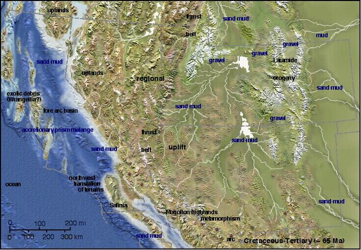
8 GY 112 Lecture Notes D. Haywick (2006) 8 The Cretaceous strata deposited in Alabama and other parts of the Coastal Plain (i.e., the eastern side of the Appalachian Mountains in VA, NC, SC, GA and FL) consists of a variety of sedimentary rock types. Much of it is siliciclastic and dominated by nonmarine (e.g., rivers), marginal marine (e.g., deltas, lagoons, estuaries, beaches, barrier islands) or shallow marine environments (e.g., shelf). In some areas (and/or at different times), limestones were deposited on the Coastal Plain. In the late Cretaceous (and into the Tertiary), thick sequences of chalk were deposited. In Alabama, the Cretaceous chalk unit is called the Selma Chalk Group and it is truly impressive. The chalk is composed of the remains of exceptionally small beasties called coccolithophoroids (coccospheres for short). Coccospheres are a type of marine algae that is surrounded by small calcitic plates each no more than a few microns across (0.001 mm) called coccoliths. It is the coccoliths that are left behind after the algae dies and they are so small that you need an electron microscope to examine them. In fact, paleontologists refer to them as nannofossils to distinguish them from much larger microfossils like foraminifera which compared to coccoliths are relative giants (0.1 mm in size versus mm). A colleague of mine at the Geological Survey of Alabama (Dr. Charlie Smith) reckons that each cubic cm of Selma Chalk (e.g., about the size of a sugar cube) contains more than 40 billion coccoliths. When you consider how thick and how extensive the Selma Chalk is, it is absolutely mind boggling how many beasties are contained in this one stratigraphic unit alone. Dr. Smith also did some work to characterize the stratigraphy of the Selma Chalk. The group contains the Cretaceous-Tertiary (K-T) T K Selma Chalk outcrop on the Tombigbee river near Demopolis, AL Cretaceous paleogeography. The location of the K-T extinction inducing impact site is also shown. What effects on Alabama do you think it had?
9 GY 112 Lecture Notes D. Haywick (2006) 9 contact which is the interval that saw the end of the dinosaurs. Perhaps the best outcrop in Alabama (I think so anyway), is a K-T exposure near Moscow Landing on the Tombigbee River (see photo on previous page). I take senior students to this outcrop each fall as part of my GY 344 (Sedimentary Petrology) class. The Selma Chalk is unusual as far as chalk is concerned. Most chalks today are deposited in fairly deep water (off the edge of the shelf in water greater that 200 m), but the Selma Chalk was deposited in a shelf environment (e.g., less than 200 m water depth). Picture the waters of the Florida Keys, but instead of a clean turquoise color, the waters of Alabama Cretaceous shelf would have been milky due to all of the coccolithophoroids. Deposition along the Alabama Coastal Plain was eventually replaced by siliciclastic sediment, but not until well into the Tertiary. In other parts of the Coastal Plain (e.g., NC, VA etc.), Cretaceous sediment was siliciclastic rather than carbonate. Siliciclastic sedimentation was also occurring in the epeiric seaway that covered the interior of North America. During the Cretaceous, sea level was as high as it ever was in the Phanerozoic. The seaway (officially called the Western Interior Seaway) was continuous from the Arctic Ocean all the way to the Gulf of Mexico. Thick clastic wedges of sandstone, shale and conglomerate extended eastward from the Cordilleran Mountains into the seaway. Once again, the sediment was deposited in river, beach and shallow shelf environments. Thick coal seams indicate that there were also swamps (commonly associated with deltas) in the area. The middle part of the seaway was pretty deep; perhaps 200 or 250 deep. Roger Walker, one of the best geologists I have ever worked with (in fact he is one of the best sedimentologists of the modern era), spend a good chunk of his career studying the marine sedimentary sequences of the Western Interior Seaway. He determined that the seaway was frequently disturbed by strong storms (including hurricanes), some of which were 100s of times more powerful than what we see today. Scary stuff! Sediment deposited during the Cretaceous in the Western Interior was thick and since much of it contained organic material, it has ended up being an important petroleum and coal exploration target in Canada, the United States and Mexico. I spend a summer between my sophomore and senior undergraduate years looking for oil in Cretaceous river deposits in the subsurface of Alberta near Calgary. I got to look at cores and geophysical data sets, but alas, I did not strike it rich. While it is true that there is oil in the west, it isn t everywhere. Moreover, it s getting harder to find and we are pretty wasteful with the oil we presently have. The moral of this soapbox story is, trade in the Hummer, ride a bicycle to school. One last attempt to relate sedimentation and tectonics. In the Rocky Mountains, Triassic, Jurassic and Cretaceous sedimentary rocks have been caught up in the compressional events that ultimately formed the mountains. Additional Cretaceous sedimentary rocks have been produced as a "clastic wedge" from the sediment derived from the thrust faults that comprise the mountains, particularly in the Canadian Rockies (see cartoon on next page).
 10 Cross section across the Canadian Rockies showing the clastic wedge passing laterially into Cretaceous marine sediments Were you to visit the Rockies and like the Grand Canyon,")
10 GY 112 Lecture Notes D. Haywick (2006) 10 Cross section across the Canadian Rockies showing the clastic wedge passing laterially into Cretaceous marine sediments Were you to visit the Rockies and like the Grand Canyon, Niagara Falls, New Zealand and Newfoundland, all serious students of geology should do this once or twice in their lives, you would be amazed by the near vertical orientation of some of the sedimentary layers (see image below from As I have said previously in this class, mountain building occurs simultaneously with all other geological processes (weathering, erosion, sedimentation, lithification etc). Sometimes you have to see the actual mountains in person to fully appreciate this. The next two diagrams in today s lecture (on the next pages) are Mesozoic stratigraphic columns for the Coastal Plain Province of Alabama. The first is for the subsurface. The second is for outcrops exposed at the surface. You will see examples of subsurface and surface rocks in upcoming lab(s).
11 GY 112 Lecture Notes D. Haywick (2006) 11 Alabama Subsurface Stratigraphy (from the Geological Survey of Alabama)
12 GY 112 Lecture Notes D. Haywick (2006) 12 Alabama Mesozoic Surface Stratigraphy (from the Geological Survey of Alabama) Names and terms to be familiar with from today's lecture (Google any that you aren't familiar with) Coastal Plain Province Cores Seismic/geophysics Oceanic crust Red beds (arkose and breccia) Eagle Mills Formation Smackover Formation Luann Salt Formation Norphlet Formation Selma Chalk Formation Tallahatta Formation Navajo Formation Evaporite minerals (halite, gypsum, anhydrite) evaporite basin Algae Reefs Salt domes/diapers Petroleum reservoirs Sundance Sea Western Interior seaway Epeiric seaway (again!) Lateral accretion Coccolithophoroids/coocliths Microfossils/nannofossils
 13 This is a set of truly remarkable")


 is passive, except")
13 GY 112 Lecture Notes D. Haywick (2006) 13 This is a set of truly remarkable paleogeography maps of the southwestern portion of the United States that I found on the web ( What I like most about them is the combination of topographic expression (e.g., mountains and valleys), water depth and sedimentation. Note that the Proterozoic is fairly active (tectonically), but that much of the Paleozoic (Cambrian, Devonian, Mississippian) is passive, except for the Antler Orogeny in the Devonian. From the Triassic through the Eocene (more maps on the next page), the area is a convergent plate boundary. The Cordilleran Mountains are being born.


14 GY 112 Lecture Notes D. Haywick (2006) 14
Quiz 12 Bonus 2 (9:30-9:35 AM)
") Quiz 12 Bonus 2 (9:30-9:35 AM) UNIVERSITY OF SOUTH ALABAMA GY 112: Earth History Lectures 32 and 33: Mesozoic Sedimentation Instructor: Dr. Douglas W. Haywick Last Time Mesozoic Tectonics A) The Triassic
Quiz 12 Bonus 2 (9:30-9:35 AM) UNIVERSITY OF SOUTH ALABAMA GY 112: Earth History Lectures 32 and 33: Mesozoic Sedimentation Instructor: Dr. Douglas W. Haywick Last Time Mesozoic Tectonics A) The Triassic
Mesozoic Earth History
 Mesozoic Earth History The Mesozoic Era 251-66 MYA Breakup of Pangea Changes in air and oceanic currents Evolution of new terrestrial and marine life Opening of the Atlantic Ocean Basin Rocky Mountains
Lab 7: Sedimentary Structures
 Name: Lab 7: Sedimentary Structures Sedimentary rocks account for a negligibly small fraction of Earth s mass, yet they are commonly encountered because the processes that form them are ubiquitous in the
GY 112 Lecture Notes Significance of Fossils: Paleogeography Interpretations
 GY 112 Lecture Notes D. Haywick (2006) 1 GY 112 Lecture Notes Significance of Fossils: Paleogeography Interpretations Lecture Goals: A) What is paleogeography? B) How it works (Late Cambrian fantasy example)
GY 111 Lecture Notes Thrust Faults and the Appalachian Mountains
 GY 111 Lecture Notes D. Haywick (2007-08) 1 Lecture Goals: A) Thrust Faults B) The Appalachian Mountains GY 111 Lecture Notes Thrust Faults and the Appalachian Mountains Reference: Press et al., 2004,
Lecture 24: Paleozoic 1:
 UNIVERSITY OF SOUTH ALABAMA GY 112: Earth History Lecture 24: Paleozoic 1: Laurentia Instructor: Dr. Douglas W. Haywick Last Time (before the exam) The Cambrian Explosion A) Why a Cambrian explosion B)
GY 112 Lecture Notes Rock Review
 GY 112 Lecture Notes D. Haywick (2006) 1 GY 112 Lecture Notes Rock Review Lecture Goals: A) Recap of rock types B) Recap of the rock cycle C) Sedimentary rocks: their role in earth history Textbook reference:
GY 112: Earth History
 UNIVERSITY OF SOUTH ALABAMA GY 112: Earth History Lectures 31: Mesozoic Tectonics Instructor: Dr. Douglas W. Haywick Last Time Mesozoic Overview A) The end of the Paleozoic B) Mesozoic time frame and evolutionary
The Mesozoic. Wednesday, November 30, 11
 The Mesozoic Periods of the Mesozoic Triassic- First period of the Mesozoic era Jurassic Cretaceous- Last period of the Mesozoic era Breakup of Pangaea Stage one (Triassic) Rifting and volcanism, normal
GY 112 Lecture Notes Mesozoic Overview
 GY 112 Lecture Notes D. Haywick (2006) 1 GY 112 Lecture Notes Mesozoic Overview Lecture Goals: A) The end of the Paleozoic B) Mesozoic time frame and evolutionary developments C) Paleogeography and key
GY 112L Earth History
 GY 112L Earth History Lab 2 Vertical Successions and Sequences of Events GY 112L Instructors: Douglas Haywick, James Connors, Mary Anne Connors Department of Earth Sciences, University of South Alabama
Quiz Nine (9:30-9:35 AM)
") Quiz Nine (9:30-9:35 AM) UNIVERSITY OF SOUTH ALAAMA GY 112: Earth History Lecture 25: Paleozoic 2: More Laurentia! Instructor: Dr. Douglas W. Haywick Last Time The Paleozoic of North America 1) Laurentian
Quiz Nine (9:30-9:35 AM) UNIVERSITY OF SOUTH ALAAMA GY 112: Earth History Lecture 25: Paleozoic 2: More Laurentia! Instructor: Dr. Douglas W. Haywick Last Time The Paleozoic of North America 1) Laurentian
3/5/05 Dr. Stewart 1
 I. Physiography of Appalachian Mountains A. Introduction 1. These mountains extend from NE Canada to Georgia 2. They are the remains of a deeply eroded, ancient mountain chain once larger than the Himalayans
Terrain Units PALEOGEOGRAPHY: LANDFORM CREATION. Present Geology of NYS. Detailed Geologic Map of NYS
 NYS TOPOGRAPHY Why so? PALEOGEOGRAPHY: LANDFORM CREATION Prof. Anthony Grande AFG 014 Present Geology of NYS Detailed Geologic Map of NYS Generalized Geology Detailed Geology Hot links to the fold out
The boundary between two formations (or any distinct layers) is called a contact. Sedimentary rocks cover 75% of continents.
 is called a contact. Sedimentary rocks cover 75% of continents.") Sedimentary Rocks Sedimentary rocks form at the Earth s surface through interactions of the hydrologic system and the crust. Fortunately, many of these processes are in operation today, and geologists
Sedimentary Rocks Sedimentary rocks form at the Earth s surface through interactions of the hydrologic system and the crust. Fortunately, many of these processes are in operation today, and geologists
GY 112 Lecture Notes Laurentia in the Paleozoic (non-tectonics)
") GY 112 Lecture Notes D. Haywick (2006) 1 GY 112 Lecture Notes Laurentia in the Paleozoic (non-tectonics) Lecture Goals: A) Eastern Laurentia (pre-orogenic deposition) B) Central North America (Depositional
GY 112 Lecture Notes D. Haywick (2006) 1 GY 112 Lecture Notes Laurentia in the Paleozoic (non-tectonics) Lecture Goals: A) Eastern Laurentia (pre-orogenic deposition) B) Central North America (Depositional
Clastic Sedimentary Rocks
 Clastic Sedimentary Rocks Alessandro Grippo, Ph.D. Alternating sandstones and mudstones in Miocene turbidites Camaggiore di Firenzuola, Firenze, Italy Alessandro Grippo review Mechanical weathering creates
GEOLOGY MEDIA SUITE Chapter 5
 UNDERSTANDING EARTH, SIXTH EDITION GROTZINGER JORDAN GEOLOGY MEDIA SUITE Chapter 5 Sedimentation Rocks Formed by Surface Processes 2010 W.H. Freeman and Company Mineralogy of sandstones Key Figure 5.12
Geologic History of Texas: The Making of Texas Over 1.5 Billion Years
 # 4 Geologic History of Texas: The Making of Texas Over 1.5 Billion Years Dr. Richard Kyle March 24, 2000 Produced by and for Hot Science - Cool Talks by the Environmental Science Institute. We request
Bowen s Chemical Stability Series
 Lab 5 - Identification of Sedimentary Rocks Page - Introduction Sedimentary rocks are the second great rock group. Although they make up only a small percentage of the rocks in the earth s crust (~5%)
24. Ocean Basins p
 24. Ocean Basins p. 350-372 Background The majority of the planet is covered by ocean- about %. So the majority of the Earth s crust is. This crust is hidden from view beneath the water so it is not as
Sediment and sedimentary rocks Sediment
 Sediment and sedimentary rocks Sediment From sediments to sedimentary rocks (transportation, deposition, preservation and lithification) Types of sedimentary rocks (clastic, chemical and organic) Sedimentary
GY 111 Lecture Note Series Sedimentary Environments 2: Rivers and Deltas
 GY 111 Lecture Notes D. Haywick (2008-09) 1 GY 111 Lecture Note Series Sedimentary Environments 2: Rivers and Deltas Lecture Goals A) Rivers and Deltas (types) B) Water Flow and sedimentation in river/deltas
EPS 50 Lab 4: Sedimentary Rocks
 Name: EPS 50 Lab 4: Sedimentary Rocks Grotzinger and Jordan, Chapter 5 Introduction In this lab we will classify sedimentary rocks and investigate the relationship between environmental conditions and
GLG Chapter 7 Sedimentary Environments & Rocks
 GLG 101 - Chapter 7 Sedimentary Environments & Rocks Name Note, Oct 11: I ll be writing this study sheet over the next few days. Each day I will add questions until the entire chapter is done, hopefully
Geology 252, Historical Geology, California State University, Los Angeles - professor: Dr. Alessandro Grippo
 LAB # 1 - CLASTIC ROCKS Background: - Mechanical and Chemical Weathering - Production of Clastic Sediment - Classification of Sediment according to size: Gravel, Sand, Silt, Clay - Erosion, Transportation
Geologic Trips San Francisco and the Bay Area
 Excerpt from Geologic Trips San Francisco and the Bay Area by Ted Konigsmark ISBN 0-9661316-4-9 GeoPress All rights reserved. No part of this book may be reproduced without written permission in writing,
Structural Geology of the Mountains
 Structural Geology of the Mountains Clinton R. Tippett Shell Canada Limited, Calgary, Alberta clinton.tippett@shell.ca INTRODUCTION The Southern Rocky Mountains of Canada (Figure 1) are made up of several
Continental Landscapes
 Continental Landscapes Landscape influenced by tectonics, climate & differential weathering Most landforms developed within the last 2 million years System moves toward an equilibrium Continental Landscapes
1 Earth s Oceans. TAKE A LOOK 2. Identify What are the five main oceans?
 CHAPTER 13 1 Earth s Oceans SECTION Exploring the Oceans BEFORE YOU READ After you read this section, you should be able to answer these questions: What affects the salinity of ocean water? What affects
Lecture Outlines PowerPoint. Chapter 12 Earth Science 11e Tarbuck/Lutgens
 Lecture Outlines PowerPoint Chapter 12 Earth Science 11e Tarbuck/Lutgens 2006 Pearson Prentice Hall This work is protected by United States copyright laws and is provided solely for the use of instructors
Unit 6: Interpreting Earth s History
 Unit 6: Interpreting Earth s History How do we know that the Earth has changed over time? Regent s Earth Science Name: Topics Relative Dating Uniformitarianism Superposition Original Horizontality Igneous
Understanding Earth Fifth Edition
 Understanding Earth Fifth Edition Grotzinger Jordan Press Siever Chapter 5: SEDIMENTATION: Rocks Formed by Surface Processes Lecturer: H Mohammadzadeh Assistant professors, Department of Geology, FUM Copyright
Sedimentary Rocks, our most Valuable Rocks. Or, what you will probably find when you are outdoors exploring.
 Sedimentary Rocks, our most Valuable Rocks Or, what you will probably find when you are outdoors exploring. Sedimentary rocks give us evidence to earth s earlier history. We look at processes happening
Why is it called the "Inland Basins" Region?
 Learning Series: Rocks of the Southeastern U. S. The BIG Picture Why is it called the "Inland Basins" Region? Inland from the mountains, the Earth s crust was buckled (downwarped) into a series of depressions
Answers: Internal Processes and Structures (Isostasy)
") Answers: Internal Processes and Structures (Isostasy) 1. Analyse the adjustment of the crust to changes in loads associated with volcanism, mountain building, erosion, and glaciation by using the concept
Answers: Internal Processes and Structures (Isostasy) 1. Analyse the adjustment of the crust to changes in loads associated with volcanism, mountain building, erosion, and glaciation by using the concept
The Nature of Sedimentary Rocks
 The Nature of Sedimentary Rocks Sedimentary rocks are composed of: Fragments of other rocks Chemical precipitates Organic matter or biochemically produced materials The Nature of Sedimentary Rocks Sedimentary
3. The diagram below shows how scientists think some of Earth's continents were joined together in the geologic past.
 1. The map below shows the present-day locations of South America and Africa. Remains of Mesosaurus, an extinct freshwater reptile, have been found in similarly aged bedrock formed from lake sediments
B.C. s Offshore Oil and Gas: a Guide to the Geology and Resources.
 B.C. s Offshore Oil and Gas: a Guide to the Geology and Resources. Introduction Beneath the offshore regions of British Columbia are four moderately large, geologically young sedimentary basins (Figure
Cattaraugus Creek: A Story of Flowing Water and the Geology of the Channel It Flows Through Presentation to West Valley Citizen Task Force 4/27/16
 Cattaraugus Creek: A Story of Flowing Water and the Geology of the Channel It Flows Through Presentation to West Valley Citizen Task Force 4/27/16 Raymond C. Vaughan, Ph.D. What happens if you drop a
5 Time Marches On. TAKE A LOOK 1. Identify What kinds of organisms formed the fossils in the picture?
 CHAPTER 6 5 Time Marches On SECTION The Rock and Fossil Record BEFORE YOU READ After you read this section, you should be able to answer these questions: How do geologists measure time? How has life changed
The United States & Canada. A Regional Study of Anglo America
 A Regional Study of Anglo America Landform Regions of the United States & Canada world leaders in agricultural and industrial production because of... VAST LANDS stretch from the Atlantic Ocean on the
Copyright McGraw-Hill Education. All rights reserved. No reproduction or distribution without the prior written consent of McGraw-Hill Education
 Copyright McGraw-Hill Education. All rights reserved. No reproduction or distribution without the prior written consent of McGraw-Hill Education Tibetan Plateau and Himalaya -southern Asia 11.00.a VE 10X
Earth Science Lesson Plan Quarter 3, Week 7, Day 1
 Earth Science Lesson Plan Quarter 3, Week 7, Day 1 Outcomes for Today Standard Focus: PREPARE 1. Background knowledge necessary for today s reading. Continental ice sheets increase the weight of the Earth
GY 111: Physical Geology
 UNIVERSITY OF SOUTH ALABAMA GY 111: Physical Geology Lecture 14: Sedimentary Rocks Part 2: Alluvial Fans and Rivers Instructor: Dr. Douglas W. Haywick Last Time 1) Types of Sediment 2) Sedimentary Rock
Phanerozoic (last 0.54 by) Tectonics Climate Life
 Tectonics Climate Life") Phanerozoic (last 0.54 by) Tectonics Climate Life Tools for Locating Past Continent Positions Fossils depending on climate Alignment of geological features Geometrical fit of continental margins Similarity
Phanerozoic (last 0.54 by) Tectonics Climate Life Tools for Locating Past Continent Positions Fossils depending on climate Alignment of geological features Geometrical fit of continental margins Similarity
1. Canadian Energy Use
 1 Unit 3 Energy 2 1. Canadian Energy Use Why are Canadians the sixth highest energy users in the world? Our major industries are energy intensive, overall industry consumes 31% of all energy in Canada.
Lecture Outline Wednesday - Friday February 14-16, 2018
 Lecture Outline Wednesday - Friday February 14-16, 2018 Quiz 2 scheduled for Friday Feb 23 (Interlude B, Chapters 6,7) Questions? Chapter 6 Pages of the Past: Sedimentary Rocks Key Points for today Be
PALEOGEOGRAPHY of NYS. Definitions GEOLOGIC PROCESSES. Faulting. Folding 9/6/2012. TOPOGRAPHIC RELIEF MAP of NYS GRADATIONAL TECTONIC
 TOPOGRAPHIC RELIEF MAP of NYS PALEOGEOGRAPHY of NYS Prof. Anthony Grande AFG 2012 Definitions GEOLOGIC PROCESSES Geography: study of people living on the surface of the earth. Geology: the scientific study
GY 112 Lecture Notes Archean Geology
 GY 112 Lecture Notes D. Haywick (2006) 1 GY 112 Lecture Notes Archean Geology Lecture Goals: A) Time frame (the Archean and earlier) B) Rocks and tectonic elements (shield/platform/craton) C) Tectonics
Section 7. Reading the Geologic History of Your Community. What Do You See? Think About It. Investigate. Learning Outcomes
 Chapter 3 Minerals, Rocks, and Structures Section 7 Reading the Geologic History of Your Community What Do You See? Learning Outcomes In this section, you will Goals Text Learning Outcomes In this section,
Chapter 6, Part Colonizers arriving in North America found extremely landscapes. It looked different to region showing great.
 Social Studies 9 Unit 1 Worksheet Chapter 6, Part 1. 1. Colonizers arriving in North America found extremely landscapes. It looked different to region showing great. 2. The Earth is years old and is composed
Depositional Environments. Depositional Environments
 Depositional Environments Geographic area in which sediment is deposited Characterized by a combination of geological process & environmental conditions Depositional Environments Geological processes:
Fossils, Geologic Time, Absolute & Relative Dating, and Natural Resources. Chapters 5 & 6
 Fossils, Geologic Time, Absolute & Relative Dating, and Natural Resources Chapters 5 & 6 How Do Fossils Form? Fossils are found in sedimentary rocks like sandstone, limestone, and shale In Virginia, most
What type of land feature is located at Point A? A Cliff B Delta C Mountain D Valley
 1 What type of land feature is located at Point A? A Cliff B Delta C Mountain D Valley Alfred Wegener s theory of continental drift was 2 not accepted by scientists when the theory was first proposed.
A TRIP THROUGH VIRGINIA GEOLOGY FROM AN ENGINEER S PERSPECTIVE
 A TRIP THROUGH VIRGINIA GEOLOGY FROM AN ENGINEER S PERSPECTIVE Bob Moss, PE Principal Engineer ECS Mid Atlantic, LLC The Engineer Parent WHY IS AN UNDERSTANDING OF LOCAL GEOLOGY IMPORTANT? It provides
Sedimentary Rocks. Origin, Properties and Identification. Geology Laboratory GEOL 101 Lab Ray Rector - Instructor
 Sedimentary Rocks Origin, Properties and Identification Geology Laboratory GEOL 101 Lab Ray Rector - Instructor Sedimentary Rock Origin and Identification Lab Pre-Lab Internet Link Resources 1) http://www.rockhounds.com/rockshop/rockkey/index.html
SAMPLE QUESTIONS FOR GEOLOGY 103, TEST 1
 SAMPLE QUESTIONS FOR GEOLOGY 103, TEST 1 The correct answers are listed at the bottom (no peeking!). These questions are to give you an idea of the type of questions that will be asked. They are not a
Unit 5 Possible Test Questions Mesozoic and Cenozoic Eras HISTORICAL GEOLOGY
 Revised 8/16 Unit 5 Possible Test Questions Mesozoic and Cenozoic Eras HISTORICAL GEOLOGY Mesozoic Era Eons, Eras and Periods 1. List the Mesozoic periods in order (oldest to youngest). End of the Paleozoic
Small area of the ocean that is partially surrounded by land. The Ocean Basins. Three Major Oceans. Three Major Oceans. What is a SEA?
 The Ocean Basins How Deep is the Ocean? 1 2 Three Major Oceans Three Major Oceans Pacific Atlantic the shallowest ocean (3.3km average depth) Indian second shallowest ocean (3.8km average depth) Pacific
Mesozoic Earth History Million years ago Triassic Jurassic Cretaceous
 Mesozoic Earth History 245-65 Million years ago Triassic Jurassic Cretaceous Geologic Time Scale www.geo.ucalgary.ca/~macrae/timescale/time_scale.gif Main Happenings in Mesozoic Breakup of Pangaea Lots
Foundations of Earth Science, 6e Lutgens, Tarbuck, & Tasa
 Foundations of Earth Science, 6e Lutgens, Tarbuck, & Tasa Oceans: The Last Frontier Foundations, 6e - Chapter 9 Stan Hatfield Southwestern Illinois College The vast world ocean Earth is often referred
UNIT 4 SEDIMENTARY ROCKS
 UNIT 4 SEDIMENTARY ROCKS WHAT ARE SEDIMENTS Sediments are loose Earth materials (unconsolidated materials) such as sand which are transported by the action of water, wind, glacial ice and gravity. These
Mammoth Cave National Park, Kentucky
 Mammoth Cave National Park, Kentucky Objectives of Today s Lecture Refresher on Sedimentary Depositional Systems and Rock Classifications Transgressive and Regressive Marine Environments Carbonate Depositional
1. Base your answer to the following question on The diagram below represents a part of the crystal structure of the mineral kaolinite.
 1. Base your answer to the following question on The diagram below represents a part of the crystal structure of the mineral kaolinite. An arrangement of atoms such as the one shown in the diagram determines
Potential short answer questions: What is Pangea? Describe at least 4 pieces of evidence that led Wegener to suggest the theory of Continental Drift.
 6th Grade Earth Science Fall Semester Mid-Term Study Guide The mid-term may include: 4 short answer questions,1-2 sketches to draw and/or label, 4 partially filled charts which you should complete, 30
Earth Science. Name Block. Unit 3 Review Worksheet. Circle the letter that corresponds to the correct answer
 Earth Science Unit 3 Review Worksheet Name Block Circle the letter that corresponds to the correct answer 1. Which geologic principle is used when a geologist observes an outcrop or rocks and determines
Beneath our Feet: The 4 Layers of the Earty by Kelly Hashway
 Beneath our Feet: The 4 Layers of the Earty by Kelly Hashway The Earth is more than a giant ball made up of dirt, rocks, and minerals. The Earth may look like a giant ball from when looking at it from
Question #1: What are some ways that you think the climate may have changed in the area where you live over the past million years?
 Reading 5.2 Environmental Change Think about the area where you live. You may see changes in the landscape in that area over a year. Some of those changes are weather related. Others are due to how the
Sediment and Sedimentary rock
 Sediment and Sedimentary rock Sediment: An accumulation of loose mineral grains, such as boulders, pebbles, sand, silt or mud, which are not cemented together. Mechanical and chemical weathering produces
Rockall Plateau. OCN 201: Shelf Sediments
 Rockall Plateau OCN 201: Shelf Sediments Classification by Size Classification by Mode of Formation Detrital sediments Transported and deposited as particles Derived from weathering of pre-existing rocks
Outline 16: The Mesozoic World: Formation of Oil Deposits (with a side trip to the Devonian Marcellus Shale)
") Outline 16: The Mesozoic World: Formation of Oil Deposits (with a side trip to the Devonian Marcellus Shale) The first commercial oil well was drilled by Colonel Edwin Drake in Titusville, Pennsylvania,
Outline 16: The Mesozoic World: Formation of Oil Deposits (with a side trip to the Devonian Marcellus Shale) The first commercial oil well was drilled by Colonel Edwin Drake in Titusville, Pennsylvania,
Plio-Pleistocene Geology
 UNIVERSITY OF SOUTH ALABAMA GY 112: Earth History Plio-Pleistocene Geology Instructor: Dr. Douglas W. Haywick Last Time A) Cenozoic Tectonics Western North American tectonic provinces Plateaus and canyons
The Sea Floor. Chapter 2
 The Sea Floor Chapter 2 Geography of the Ocean Basins World ocean is the predominant feature on the Earth in total area Northern Hemisphere = 61% of the total area is ocean. Southern Hemisphere = about
Sedimentary Rocks. Origin, Properties and Identification. Physical Geology GEOL 100. Ray Rector - Instructor
 Sedimentary Rocks Origin, Properties and Identification Physical Geology GEOL 100 Ray Rector - Instructor Sedimentary Rock Origin and Identification Lab Pre-Lab Internet Link Resources 1) http://www.rockhounds.com/rockshop/rockkey/index.html
Chapter 2: Plate Tectonics: A Unifying Theory
 Chapter 2: Plate Tectonics: A Unifying Theory Chapter Outline 2.1 Introduction 2.2 Early Ideas About Continental Drift 2.3 What Is the Evidence for Continental Drift? 2.4 Features of the Seafloor 2.5 Earth
GEOLOGY OF TODMORDEN MOOR 2 BACKGROUND
 GEOLOGY OF TODMORDEN MOOR 2 BACKGROUND 1) THE CARBONIFEROUS SERIES OF ROCKS The rocks of the Todmorden district are of the Carboniferous Series and were first laid down in an ancient sea, which covered
PLATE TECTONICS THEORY
 PLATE TECTONICS THEORY Continental drift Sea floor spreading CONTINENTAL DRIFT CONTINENTAL DRIFT 1. The fitness of continents and Continental Reconstruction Earth ~200 million years ago 1.1 Geometrical
GY 402: Sedimentary Petrology
 UNIVERSITY OF SOUTH ALABAMA GY 402: Sedimentary Petrology Lecture 13: Immature Siliciclastic Sedimentary Environments Alluvial Fans, Braided Streams Instructor: Dr. Douglas W. Haywick Last Time Immature
Module 10: Resources and Virginia Geology Topic 4 Content: Virginia Geology Notes
 Virginia is composed of a very diverse landscape that extends from the beaches and barrier islands all of the way to the highly elevated Appalachian Plateau. Geologists have discovered ancient shallow
Lecture Outlines PowerPoint. Chapter 13 Earth Science 11e Tarbuck/Lutgens
 Lecture Outlines PowerPoint Chapter 13 Earth Science 11e Tarbuck/Lutgens 2006 Pearson Prentice Hall This work is protected by United States copyright laws and is provided solely for the use of instructors
Your web browser (Safari 7) is out of date. For more security, comfort and the best experience on this site: Update your browser Ignore
 is out of date. For more security, comfort and the best experience on this site: Update your browser Ignore") Your web browser (Safari 7) is out of date. For more security, comfort and the best experience on this site: Update your browser Ignore BEDRO CK For the complete encyclopedic entry with media resources,
Your web browser (Safari 7) is out of date. For more security, comfort and the best experience on this site: Update your browser Ignore BEDRO CK For the complete encyclopedic entry with media resources,
Chapter Two. Figure 02_02. Geography of the Ocean Basins. The Sea Floor
 Chapter Two The Sea Floor Geography of the Ocean Basins Figure 02_02 The world ocean is the predominant feature on the Earth in total area. In the Northern Hemisphere, 61% of the total area is ocean. In
Biostratigraphic and Lithostratigraphic Correlation of Sedimentary Strata in the Atlantic Coastal Plain
 Biostratigraphic and Lithostratigraphic Correlation of Sedimentary Strata in the Atlantic Coastal Plain Introduction to the Atlantic Coastal Plain (Please read this page prior to doing the lab) The Atlantic
Movement of the Earth s Crust: Formation of: Mountain s Plateau's and Dome s
 Movement of the Earth s Crust: Formation of: Mountain s Plateau's and Dome s References Information taken from several places including Prentice Hall Earth Science: @ http://www.eram.k12.ny.us/education/components/docmgr/default.php?sectiondetaili
Earth Science, (Tarbuck/Lutgens) Chapter 10: Mountain Building
 Chapter 10: Mountain Building") Earth Science, (Tarbuck/Lutgens) Chapter 10: Mountain Building 1) A(n) fault has little or no vertical movements of the two blocks. A) stick slip B) oblique slip C) strike slip D) dip slip 2) In a(n) fault,
Earth Science, (Tarbuck/Lutgens) Chapter 10: Mountain Building 1) A(n) fault has little or no vertical movements of the two blocks. A) stick slip B) oblique slip C) strike slip D) dip slip 2) In a(n) fault,
Ch. 17 Review. Life in the Cretaceous
 Ch. 17 Review Life in the Cretaceous Diversification of diatoms, planktonic forams, calcareous nannoplankton Diversification of mobile predators (especially mollusks and teleost fishes) Origin of the angiosperms
Geology of the Hawaiian Islands
 Geology of the Hawaiian Islands Class 12 19 February 2004 A B C D F 97 94 92 91 88 87 86 85 85 84 82 77 73 73 mean 66 64 60 69 60 57 51 29 Exam Scores Mean = 71 Median = 82/77 Any Questions? Sedimentary
Orphan Basin, Offshore Newfoundland: New seismic data and hydrocarbon plays for a dormant Frontier Basin
 Orphan Basin, Offshore Newfoundland: New seismic data and hydrocarbon plays for a dormant Frontier Basin Jerry Smee* G&G Exploration Consulting, 301 400-3rd Avenue SW, Calgary, AB, T2P 4H2 Sam Nader, Paul
MUHAMMAD S TAMANNAI, DOUGLAS WINSTONE, IAN DEIGHTON & PETER CONN, TGS Nopec Geological Products and Services, London, United Kingdom
 Geological and Geophysical Evaluation of Offshore Morondava Frontier Basin based on Satellite Gravity, Well and regional 2D Seismic Data Interpretation MUHAMMAD S TAMANNAI, DOUGLAS WINSTONE, IAN DEIGHTON
Continental drift
 Plate Tectonics Continental drift Continental drift Continental drift Continental drift Continental drift Plate Tectonics Plate Tectonics Continental Drift and Paleomagnetism Paleomagnetism Renewed interest
Sedimentary Rocks. Origin, Properties and Identification. Physical Geology GEOL 101 Lab Ray Rector - Instructor
 Sedimentary Rocks Origin, Properties and Identification Physical Geology GEOL 101 Lab Ray Rector - Instructor Sedimentary Rock Origin and Identification Lab Pre-Lab Internet Link Resources 1) http://www.rockhounds.com/rockshop/rockkey/index.html
Sedimentary Rocks. Weathering. Mechanical & Chemical Weathering. Sediments. Lithification. Deposition. Transport. Erosion.
 Lithification Sedimentary Rocks Sediments Deposition Transport Erosion Weathering Weathering The sediments that make up sedimentary rocks are produced by: Mechanical & Chemical Weathering Mechanical Weathering
PSc 201 Chapter 3 Homework. Critical Thinking Questions
 PSc 201 Chapter 3 Homework Critical Thinking Questions 1. (adapted from text) Seawater is denser than fresh water. A ship moving from the Atlantic Ocean into the Great Lakes goes from seawater to fresh
SEDIMENTARY ROCKS. Processes, Environments, Structures and Rocks. Sedimentary Processes and Rocks
 SEDIMENTARY ROCKS Processes, Environments, Structures and Rocks Sedimentary Processes and Rocks Origins of Sedimentary Rocks Sediment transport and texture Sedimentary structures Lithification Classifying
4. Starting with a supercontinent, order the following tectonic actions of the Wilson cycle from oldest (1) to most recent (4)
 to most recent (4)") Geology 101 Sample final exam (Chapters 1 9, 13, 16) Open textbook, notes, handouts, labs, field trip module, group projects, midterm exams, calculators. No collaboration. 100 points total, two hours.
Geology 101 Sample final exam (Chapters 1 9, 13, 16) Open textbook, notes, handouts, labs, field trip module, group projects, midterm exams, calculators. No collaboration. 100 points total, two hours.
Weathering, Erosion, Deposition, and Landscape Development
 Weathering, Erosion, Deposition, and Landscape Development I. Weathering - the breakdown of rocks into smaller particles, also called sediments, by natural processes. Weathering is further divided into
SEDIMENTARY ROCKS. When mountains are first formed, they are tall and jagged like the Rocky Mountains on the west coast of North America.
 SEDIMENTARY ROCKS When mountains are first formed, they are tall and jagged like the Rocky Mountains on the west coast of North America. Over time (millions of years) mountains become old mountains like
To get you thinking Explain how these different layers of rock formed? Why are these layers different colors? Sedimentary Rocks
 To get you thinking Explain how these different layers of rock formed? Why are these layers different colors? Sedimentary Rocks Bryce Canyon, Utah Badlands, South Dakota Weathering Whenever rock is exposed
UNIVERSITY OF SOUTH ALABAMA. GY 112: Earth History. Lecture 36: Plio-Pleistocene Geology. Instructor: Dr. Douglas W. Haywick
 UNIVERSITY OF SOUTH ALABAMA GY 112: Earth History Lecture 36: Plio-Pleistocene Geology Instructor: Dr. Douglas W. Haywick Last Time A) Cenozoic Overview and Tectonics Western North American tectonic provinces