1. Canadian Energy Use
|
|
|
- Johnathan Shaw
- 5 years ago
- Views:
Transcription

1 1 Unit 3 Energy


2 2 1. Canadian Energy Use Why are Canadians the sixth highest energy users in the world? Our major industries are energy intensive, overall industry consumes 31% of all energy in Canada.

3 3 1. Canadian Energy Use Canada is a very large nation, therefore multiple modes of transportation are needed. Transportation is dependent on energy and consumes 30% of all energy in Canada
4 4 1. Canadian Energy Use Canada has long, dark and cold winters, therefore large amounts of energy are consumed for heat and light Residential users consume 19% of all energy, commercial (or business) users consume 15%
5 5 1. Canadian Energy Use Key Points to Remember: Ontario has high energy use because: Large population Large industrial base Alberta & Saskatchewan have high energy uses because: Energy production is centered in these two provinces. It takes a great amount of energy to make energy. Energy is more accessible (cheaper), therefore use is high.

6 2. Sources of Canada s Energy 6
7 2. Sources of Canada s Energy Fossil Fuels 70% Coal 52% Natural Gas 15% Oil 3% Nuclear 19% Hydro 9% Tidal 0.5% Solar 0.5% Geothermal 0.5% Wind 0.5% 7
8 8 3. Nonrenewable Energy Sources Fossil Fuels: Examples: petroleum (oil), natural gas and coal They are composed of hydrocarbons (atoms of hydrogen and carbon) They are formed from the remains of plants and animals that once lived in tropical swamps and shallow seas The carbon compounds that were once their bodies, and were once storehouses of the sun s energy
9 9 3. Nonrenewable Energy Sources As these remains fell to the bottom of the seas or swamps, they were buried in soft muds and preserved from further decay Eventually these muds were covered by other sediments The mud became sedimentary rock as pressure from above was placed upon it

10 10 3. Nonrenewable Energy Sources Animation: o/earth2/content/chapter_14/animati ons.asp
11 11 3. Nonrenewable Energy Sources This process repeated itself and huge basins containing layers upon layers of carbon rich sediments were formed As millions of years passed these carbon sediments were transformed into petroleum through pressure and chemical reactions These basins are the world s major reservoirs of fossil fuels, specifically petroleum and natural gas
12 12 4. Canada s Sedimentary Basins Sedimentary Basin: An area in which sediments have accumulated during a particular time period at a significantly greater rate and to a significantly greater thickness than surrounding areas. They usually contain hydrocarbons the source of fossil fuels
13 13 4. Canada s Sedimentary Basins Western Canada Largest land basin, located in the Northwest Territories, Yukon, British Columbia, Alberta, Saskatchewan and Manitoba Cordilleran British Columbia and the Yukon Beaufort Sea-Mackenzie Delta Arctic Islands
14 14 4. Canada s Sedimentary Basins Eastern Canada-Offshore The largest offshore basin, located on the continental shelf off the Atlantic coast St. Lawrence Encompasses the St. Lawrence, Nova Scotia, western Newfoundland, Lake Huron, Lake Erie, and Lake Ontario Hudson Bay located in parts of northern Ontario and Quebec
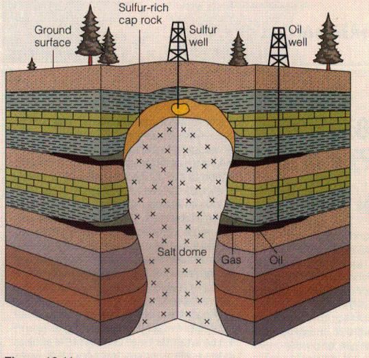
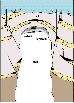
15 15 Fig 11.9 page 215 Draw, label and colour all 7 sedimentary basins Label the provinces and territories

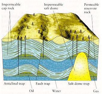
16 5. Oil and Natural Gas Traps Fig
17 17 5. Oil and Natural Gas Traps Reservoir Rocks: Often porous rock such as sandstone or limestone where petroleum can mix with water Traps: Areas in the reservoir rock where oil floats above water and accumulates Cap Rock: Rock that prevents oil from flowing out of the traps
18 18 5. Oil and Natural Gas Traps Animation: o/earth2/content/chapter_14/animati ons.asp
19 19
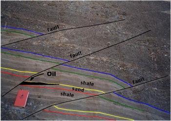
20 20 5. Oil and Natural Gas Traps Fault Trap Oil and natural gas form in the impervious shale layer (source rock) The oil and natural gas migrate upward in the layer of porous sandstone (reservoir rock) above the source rock A fault develops, cutting off the sandstone layer and tilting it on an angle A porous layer is blocked by impervious shale (cap rock) The oil and natural gas are trapped
21 21
22 22 5. Oil and Natural Gas Traps Salt Dome Trap Oil and natural gas form in the impervious shale layer (source rock) Oil and natural gas migrate upward in a layer of porous sandstone (reservoir rock) A salt dome develops, cutting through the porous layers The salt dome deflects the layer upwards Oil and natural gas are trapped in pockets between the salt dome and the impervious shale layers (cap rocks)
23 23
24 24 6. How is oil discovered? It can be seeping out of the ground (Turner Valley, Alberta) Using geology Oil occurs where sedimentary rock is gently folded or faulted or where salt domes and porous reefs are buried under the surface

25 25 6. How is oil discovered? Using seismic exploration Seismic waves are transmitted below the surface of the earth and the amount of time it takes for the reflected wave to return to the surface indicates what type of geological formations exist il2.html Shell Animation
26 26 6. How is oil discovered? Drilling wildcat wells is still the only definite way to determine if oil is present When an oilfield is discovered, exploration wells are drilled outwards from the original source to determine the size and extent of the field


27 27 7. Canada s Oil Supply Conventional Oilfields: These produce oil in a liquid form that is capable of flowing naturally or being pumped without processing
28 28 7. Canada s Oil Supply Most convectional fields in Canada occur in Alberta, Saskatchewan, British Columbia and the Northwest Territories No new oilfields have been discovered in the Western Canada Sedimentary Basin in the last 20 years, however production and consumption has continued at high rates
29 29 7. Canada s Oil Supply Fear of exhausting conventional oilfield. What are the options? A. Technological advances have increased the amount of oil that is being recovered from conventional oilfields Despite advanced technology Only 30% of all the oil in a conventional oilfield is recovered
30 30 7. Canada s Oil Supply B. Exploration of additional conventional oilfields, like the arctic or offshore C. We must attempt to use alternate energy sources
31 31 8. Types of Oil Reserves Potential Reserves: Known deposits of oil that cannot be recovered profitable under existing conditions Actual Reserves: Known oil reserves that can be developed profitably


32 32 9. Arctic Exploration Potential reserves lie in the Beaufort Sea-Mackenzie Delta and in the Arctic Islands sedimentary basins (under the ocean floor)

33 33 9. Arctic Exploration Problems associated with recovering Arctic oil: Extremely cold temperatures Long periods of darkness Ice conditions Extreme distances from the market causes difficulties with transportation of the product (via tanker or pipeline?)
34 34 9. Arctic Exploration Arctic oil will be developed if: World oil prices increase Known conventional oil supplies are exhausted New technology lowers the cost of arctic exploration and production Canada changes its domestic policy and mandates self-sufficiency
35 Why would oil and gas deposits in the Arctic have to be much larger than the deposits in Alberta and Saskatchewan before they are developed? 35
36 36 Cold temperatures, long periods of darkness and ice conditions make exploration and development very costly The oil and gas is developed far away from consumers in southern Canada, so transportation to market is more expensive Therefore the reserves have to be larger, otherwise they wouldn t make any profit


37 Offshore Oil and Gas Actual reserves lie in Eastern-Canada Offshore Sedimentary Basin The Hibernia and Terra Nova Oilfields are off the Grand Banks The Panuke and Cohasset Oilfields are off the Scotian Shelf
38 Offshore Oil Rigs Type of Rig Depth of Sea Water Anchoring Structure Submersible 20m Cement foundation on sea floor Jack-up 100m Pylons extending into sea floor Semi-submersible anchored Semi-submersible dynamically positioned 200m 2000m Underwater pontoons anchored with cables to sea floor Underwater pontoons stabilized with an intricate system of values and pumps 38

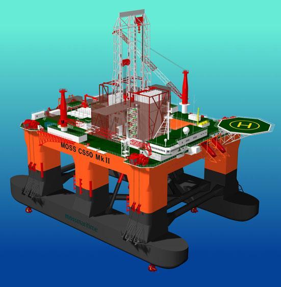
39 39 Examples: Semi-submersible Dynamically Positioned


40 Terra Nova 40 Hibernia What type of Oil Rig is used for Terra Nova?
41 How does the oil industry help the economy? The sale of oil will generate profit that will be circulated in the economy The creation of jobs involved directly with the drilling project and refining/processing oil The creation of jobs associated with the construction of the project The creation of jobs associated with the many businesses and industries that must support the oil companies and their employees
42 42 Energy production is 7% of our GDP (gross domestic product) GDP is the value of all goods and services produced in a country
43 43 Total export all things we send out of Canada to other countries Energy is 11% of our total export
Geography 3202 Unit 4 S.C.O. 4.3 & 4.5. Primary Resource Activities Offshore Oil And Gas
 Geography 3202 Unit 4 S.C.O. 4.3 & 4.5 Primary Resource Activities Offshore Oil And Gas Factors Affecting The Decision To Recover Offshore Oil And Gas (4.3.1) Physical Factors 1. Ocean Related Factors
B.C. s Offshore Oil and Gas: a Guide to the Geology and Resources.
 B.C. s Offshore Oil and Gas: a Guide to the Geology and Resources. Introduction Beneath the offshore regions of British Columbia are four moderately large, geologically young sedimentary basins (Figure
Outline 16: The Mesozoic World: Formation of Oil Deposits (with a side trip to the Devonian Marcellus Shale)
") Outline 16: The Mesozoic World: Formation of Oil Deposits (with a side trip to the Devonian Marcellus Shale) The first commercial oil well was drilled by Colonel Edwin Drake in Titusville, Pennsylvania,
Outline 16: The Mesozoic World: Formation of Oil Deposits (with a side trip to the Devonian Marcellus Shale) The first commercial oil well was drilled by Colonel Edwin Drake in Titusville, Pennsylvania,
Today s oil is yesterday s plankton
 Oil and Gas Basics 2 Today s oil is yesterday s plankton Small marine and lake organisms live in surface waters They die, fall to the bottom and get buried into an organic rich sedimentary layer If geologic
Social Studies 9 UNIT 2 GEOGRAPHIC INFLUENCES ON IDENTITY: PLACE AND PEOPLE
 Social Studies 9 UNIT 2 GEOGRAPHIC INFLUENCES ON IDENTITY: PLACE AND PEOPLE The Structure of the Earth To understand the forces that create Canada's physical landscape we must understand the structure
Subsurface Geology and Resource Exploration
 LAB 11. Subsurface Geology and Resource Exploration Locating earth resources such as aluminum, copper, gold and gemstones has been an important job for geologists for a long time. This lab deals with the
Geologic Resources. Geologic Resources and Society. Geologic Resources and Society
 Geologic Resources Our entire society rests upon - and is dependent upon - our water, our land, our forests, and our minerals. How we use these resources influences our health, security, economy, and well-being.
Exploration, Drilling & Production
 Nontechnical Guide to PETMOLEUM Geology, Exploration, Drilling & Production Third Edition Norman J. Hyne, Ph.D. Contents Preface *i Introduction 1 The Nature of Gas and Oil 1 Petroleum 1 The Chemistry
Markville. CGC 1DL/PL Geography. Geography of Canada. Natural Environment Unit Test
 Markville CGC 1DL/PL Geography Geography of Canada Natural Environment Unit Test Name: Thinking /10 Knowledge /10 Application /10 Communication /10 Part A: Blanks (1 mark each) Thinking Choose the correct
CANADA S LANDFORM REGIONS
 CANADA S LANDFORM REGIONS Canada s Regions Canada is divided into Eight major regions. A Region is an area that is defined on the basis of the presence or absence of certain characteristics: Age of rock
Reservoirs and Production
 Lesson Plan Page 1 Topic: Reservoirs and production Topic Overview: Porosity refers to the percentage of holes (pores) in the rock. Permeability is the ability of fluids to travel through porous rocks.
Sedimentary rocks. Mechanical Weathering. Weathering. Chemical weathering. Rates of weathering. Fossil Fuel Resources. Two kinds of weathering
 Sedimentary rocks Fossil Fuel Resources Exam next Tuesday February 14 Bring Scantron and Review Questions About 75% of all rock outcrops on the continents Important to reconstruct much of Earth's history
The United States & Canada. A Regional Study of Anglo America
 A Regional Study of Anglo America Landform Regions of the United States & Canada world leaders in agricultural and industrial production because of... VAST LANDS stretch from the Atlantic Ocean on the
Unit 1 Physical Setting
 Unit 1 Physical Setting Chapter 1: Finding Your Way Chapter 2: Our Natural Environment Chapter 3: The Changing Weather Chapter 4: A Place To Live Chapter 1: Finding Our Way Key Terms Lines of Latitude
SEDIMENTARY ROCKS. When mountains are first formed, they are tall and jagged like the Rocky Mountains on the west coast of North America.
 SEDIMENTARY ROCKS When mountains are first formed, they are tall and jagged like the Rocky Mountains on the west coast of North America. Over time (millions of years) mountains become old mountains like
The Niagara Escarpment extends from western New York, through the GTA all the way up to Manitoulin Island and into Michigan and Wisconsin.
 is southern Ontario s most prominent topographic feature, extending more than 500 kilometres from western New York, through Niagara Falls and the western part of the Greater Toronto Area (GTA), and north
LANDFORM REGIONS IN CANADA. Classroom Notes and Descriptions
 LANDFORM REGIONS IN CANADA Classroom Notes and Descriptions Landform Regions in Canada There are eight distinct landforms in Canada: Western Cordillera Region Interior Plains Canadian Shield Hudson Bay
The Duvernay, Horn River and Canol Shales
 Western Canada s Giant Gas and Liquids Fairway: The Duvernay, Horn River and Canol Shales Brad J. Hayes Petrel Robertson Consulting Ltd. CERI 2015 Natural Gas Conference 1 Introduction Emerging unconventional
Sediment and sedimentary rocks Sediment
 Sediment and sedimentary rocks Sediment From sediments to sedimentary rocks (transportation, deposition, preservation and lithification) Types of sedimentary rocks (clastic, chemical and organic) Sedimentary
PETROLEUM 101. Mark Shrimpton Jacques Whitford
 PETROLEUM 101 Mark Shrimpton Jacques Whitford PRESENTATION STRUCTURE The Offshore Petroleum Industry Petroleum Geology Petroleum Technology: Exploration agreements Geophysical exploration Drilling Development
Canadian Mapping Big Book
 Canadian Mapping Big Book Grades 4-6 Written by Lynda Golletz Illustrated by S&S Learning Materials About the Author: Lynda Golletz was an elementary school teacher for thirty-three years. She is the author
The Petroleum Industry. Phonse Fagan, P. Geo. President A.J. Fagan Consulting Inc. and
 The Petroleum Industry by Phonse Fagan, P. Geo. President A.J. Fagan Consulting Inc. and Terminology Petroleum Natural Gas Oil Crude Hydrocarbons http://www.kerrheating.com/products/fuel_oil_tanks_liberty.htm
Grade 9 Social Studies Canadian Identity. Chapter 2 Review Canada s Physical Landscape
 Grade 9 Social Studies Canadian Identity Chapter 2 Review Canada s Physical Landscape Name: Unit 1: Empowerment Terms (notes or textbook) 1. Core 2. Crust 3. Mantle 4. Magma 5. Continental drift 6. Plate
Sedimentary Rocks. Rocks made of bits & pieces of other rocks.
 Sedimentary Rocks Rocks made of bits & pieces of other rocks. Sedimentary Rocks Igneous rocks are the most common rocks on Earth, but because most of them exist below the surface you might not have seen
What is a sedimentary rock?
 Sedimentary Rocks What is a sedimentary rock? Sedimentary rocks are products of mechanical and chemical weathering They account for only 5% of the top 10 miles of the outer crust, yet most of the earth
Sedimentary Rocks Chapter 6
 Sedimentary Rocks Chapter 6 I. What is a sedimentary rock? A. Sedimentary rock 1) Rock made of detrital sediments (such as sand) or inorganic/organic chemical precipitates (such as calcite) 2) Detrital
MAINLAND NWT AND YUKON 1,128 MACKENZIE/BEAUFORT BASIN ARCTIC ISLANDS EASTERN ARCTIC HUDSON PLATFORM TOTAL PRAIRIE PROVINCES AND B.C.
 PETROLEUM EXPLORATION IN CANADA'S NORTHERN REGIONS History, Current Activity and Future Potential Gerry Reinson, Reinson Consultants Ltd. and Ken Drummond, Drummond Consulting CANADA'S NORTHERN REGIONS
Reservoirs and Production
 Lesson Plan - Page 1 Topic Reservoirs and Production Source Oil and Natural Gas, pages 24-25, 26-27 Objective The students will learn that porosity refers to the percentage of holes (pores) in the rock.
OIL AND GAS PLAYS OF THE MICHIGAN BASIN, SOUTHERN ONTARIO. Terry Carter, Consulting Geologist London, Ontario
 OIL AND GAS PLAYS OF THE MICHIGAN BASIN, SOUTHERN ONTARIO Terry Carter, Consulting Geologist London, Ontario 1 Ontario Petroleum Industries Oil and Natural Gas 1250 oil wells, 1200 gas wells, annual production
LANDFORMS CREATED AND CHANGED?
 HOW ARE LANDFORMS CREATED AND CHANGED? Landforms are created by different natural forces. Some are within Earth, and some are on the surface of Earth. Landforms can also be changed by humans. These changes
3/8/2012. Wood chemical energy stored by plants Kinetic energy Water power Wind Fossil fuels Alternatives Solar Plant derivatives Nuclear
 Wood chemical energy stored by plants Kinetic energy Water power Wind Fossil fuels Alternatives Solar Plant derivatives Nuclear http://www.dkimages.com/discover/home/s cience/physics-and-chemistry/sound-and-
Orphan Basin, Offshore Newfoundland: New seismic data and hydrocarbon plays for a dormant Frontier Basin
 Orphan Basin, Offshore Newfoundland: New seismic data and hydrocarbon plays for a dormant Frontier Basin Jerry Smee* G&G Exploration Consulting, 301 400-3rd Avenue SW, Calgary, AB, T2P 4H2 Sam Nader, Paul
Lab 7: Sedimentary Structures
 Name: Lab 7: Sedimentary Structures Sedimentary rocks account for a negligibly small fraction of Earth s mass, yet they are commonly encountered because the processes that form them are ubiquitous in the
netw rks Guided Reading Activity Essential Question: How does geography influence the way people live? Earth's Physical Geography
 Guided Reading Activity Lesson 1 Earth and the Sun Essential Question: How does geography influence the way people live? Looking at Earth Directions: What are the layers that make up Earth? Use your textbook
NC Earth Science Essential Standards
 NC Earth Science Essential Standards EEn. 2.1 Explain how processes and forces affect the Lithosphere. EEn. 2.1.1 Explain how the rock cycle, plate tectonics, volcanoes, and earthquakes impact the Lithosphere.
Chapter: Clues to Earth s Past
 Table of Contents Chapter: Clues to Earth s Past Section : Section 2: Relative Ages of Rocks Section 3: Absolute Ages of Rocks Traces of the Distant Past Paleontologists, scientists who study fossils,
The Nature of Sedimentary Rocks
 The Nature of Sedimentary Rocks Sedimentary rocks are composed of: Fragments of other rocks Chemical precipitates Organic matter or biochemically produced materials The Nature of Sedimentary Rocks Sedimentary
Dalhousie University- Petroleum Geoscience Field Methods- Trinidad Summary Report
 Dalhousie University- Petroleum Geoscience Field Methods- Trinidad Summary Report Submitted to: Offshore Energy Research Association of Nova Scotia (OERA) To fulfill requirements of the Undergraduate Student
Oil & Gas. From exploration to distribution. Week 1 V05 Origin of hydrocarbon resources part 1. Jean-Pierre Deflandre
 Oil & Gas From exploration to distribution Week 1 V05 Origin of hydrocarbon resources part 1 Jean-Pierre Deflandre W1V5 Origin of hydrocarbon resources1 p. 1 Introduction to hydrocarbon resources You will
Fossil Fuels, Chemistry of Fuels
 Fossil Fuels, Chemistry of Fuels Energy sources Wood chemical energy stored by plants Kinetic energy Water power to grind grain Wind to pump water Fossil fuels http://www.dkimages.com/discover/home/sc
Hydrocarbon Processing Techniques
 Hydrocarbon Processing Techniques Processes and Techniques Involved in Extracting and Refining Hydrocarbons Key term: Kerogen a mixture of organic matter in sediments from which petroleum is released.
GEOGRAPHY OF CANADA 1. PHYSICAL GEOGRAPHY
 GEOGRAPHY OF CANADA 1. PHYSICAL GEOGRAPHY 1.1. CANADIAN SHIELD 1.2. VOLCANOES 1.3. WESTERN CORDILLERA 1.4. CANADIAN ARCTIC 1.5. CANADIAN INTERIOR PLAINS 1.6. GREAT LAKES AND ST LAWRENCE LOWLANDS 1.7. APPALACHIAN
Natural Resources. Geology of the Hawaiian Islands. Please finish assignments. Any Questions? Class April 2004
 Geology of the Hawaiian Islands Class 27 20 April 2004 Please finish assignments HW #7 You may turn it in Thursday in class. I will not accept it after that. All Virtual Field Trip quizzes. I will accept
Sedimentary Rocks. Rocks made of bits & pieces of other rocks.
 Sedimentary Rocks Rocks made of bits & pieces of other rocks. Sedimentary Rocks Igneous rocks are the most common rocks on Earth, but because most of them exist below the surface you might not have seen
Sediment. Weathering: mechanical and chemical decomposition and disintegration of rock and minerals at the surface
 Sediment Some basic terminology Weathering: mechanical and chemical decomposition and disintegration of rock and minerals at the surface Erosion: removal of weathered rock and minerals from one place to
Grade 9 Geography Chapter 11 - Climate Connections
 Grade 9 Geography Chapter 11 - Climate Connections 1. Define: Weather. 2. In what way has weather affected your activities in the last two weeks? 3. Define: Climate. 4. Canada s climate is a function of
EQ: Discuss main geographic landforms of the U.S. & Canada and examine varied landforms in relation to their lifestyles.
 EQ: Discuss main geographic landforms of the U.S. & Canada and examine varied landforms in relation to their lifestyles. Places & Terms for Discussion Appalachian Mountains Great Plains Canadian Shield
Structural Geology of the Mountains
 Structural Geology of the Mountains Clinton R. Tippett Shell Canada Limited, Calgary, Alberta clinton.tippett@shell.ca INTRODUCTION The Southern Rocky Mountains of Canada (Figure 1) are made up of several
Tim Carr - West Virginia University
 Tim Carr - West Virginia University J. Jacquet, Marcellus Shale Education and Training Center 2 3 en.wikipedia.org/wiki/image:hubbert_peak_oil_plot.svg en.wikipedia.org/wiki/image:hubbert.jpg en.wikipedia.org/wiki/image:hubbert.jpg
Fossils, Geologic Time, Absolute & Relative Dating, and Natural Resources. Chapters 5 & 6
 Fossils, Geologic Time, Absolute & Relative Dating, and Natural Resources Chapters 5 & 6 How Do Fossils Form? Fossils are found in sedimentary rocks like sandstone, limestone, and shale In Virginia, most
Objectives: Define Relative Age, Absolute Age
 S6E5. Students will investigate the scientific view of how the earth s surface is formed. c. Classify rocks by their process of formation. g. Describe how fossils show evidence of the changing surface
ROCKS OF THE LAKE CAYUGA BASIN, NEW YORK
 Bedrock Correlation Name: Introduction: The Finger Lakes Region of New York State is underlain by rocks of Devonian Age. Use your reference tables to determine the types of rocks that outcrop around the
Energy and Mineral Resources
 1 Energy and Mineral Resources 2 3 4 5 6 7 8 9 10 11 12 13 14 15 16 17 18 19 Earth 9 th Edition Chapter 23 Energy & Mineral Resources: summary in haiku form Petroleum, gas, coal, uranium, et al. There's
Geology and Natural Resources
 Geology and Natural Resources Brought to you by: Western Michigan University Department of Geosciences and The Michigan Geological Repository for Research and Education s K-12 Outreach Program Core Kids
Geology 12 FINAL EXAM PREP. Possible Written Response Exam Questions
 Geology 12 FINAL EXAM PREP Possible Written Response Exam Questions Use this study guide to prepare for the written response portion of the final exam. Name FINAL EXAM - POSSIBLE WRITTEN RESPONSE QUESTIONS
discussion of North America s physical features, including its landforms and bodies of
 Chapter 7 Natural Environments of North America Chapter 7 focuses on the natural environments of North America. The chapter opens with a discussion of North America s physical features, including its landforms
Sediment and Sedimentary rock
 Sediment and Sedimentary rock Sediment: An accumulation of loose mineral grains, such as boulders, pebbles, sand, silt or mud, which are not cemented together. Mechanical and chemical weathering produces
Education Days Moscow Opening Session
 Education Days Moscow 2013 Basin and Petroleum Systems Modelling: Applications for Conventional and Unconventional Petroleum Exploration Risk and Resource Assessments By Dr Bjorn Wygrala Schlumberger 21-22
Mallik 2002 Gas Hydrate Production Research Well Program
 1 Mallik 2002 Gas Hydrate Production Research Well Program Gas hydrates are a naturally occurring ice-like combination of natural gas and water that have the potential to provide an immense resource of
Landform Regions of Canada
 Landform Regions of Canada The movement of the earth s plates, and the resulting folding, faulting, and volcanic activity, have combined with the forces of erosion and weathering to create a variety of
Tim Carr - West Virginia University
 Tim Carr - West Virginia University Exploration s Ultimate Goal is to Answer Four Questions: Where to Drill? What to Expect? How Certain? How Profitable? Location & Depth HC Volumes Chance of Success
Chapter 23 Lecture. Earth: An Introduction to Physical Geology. Twelfth Edition. Mineral Resources. Tarbuck and Lutgens Pearson Education, Inc.
 Chapter 23 Lecture Earth: An Introduction to Physical Geology Twelfth Edition Energy and Mineral Resources Tarbuck and Lutgens Chapter 23 Energy & Mineral Resources Renewable and Nonrenewable Resources
Climate Change in Canada
 1 Climate Change in Canada Climate change is an urgent, global concern. The implications of climate change are significant and far reaching, with the potential of impacting future generations throughout
Science 30 Unit B Chemistry and the Environment
 Science 30 Unit B Chemistry and the Environment Outcome 1: Students will analyze the sources of acids and bases and their effects on the environment. Specific Outcome 1.9: Describe impacts on the biotic
Chapter 02 The Sea Floor
 Chapter 02 The Sea Floor Multiple Choice Questions 1. One of the following is not one of the world's major ocean basins: A. Atlantic Ocean B. Arctic Ocean C. Indian Ocean D. Antarctic Ocean E. Pacific
Rockall Plateau. OCN 201: Shelf Sediments
 Rockall Plateau OCN 201: Shelf Sediments Classification by Size Classification by Mode of Formation Detrital sediments Transported and deposited as particles Derived from weathering of pre-existing rocks
Lecture Outline Wednesday - Friday February 14-16, 2018
 Lecture Outline Wednesday - Friday February 14-16, 2018 Quiz 2 scheduled for Friday Feb 23 (Interlude B, Chapters 6,7) Questions? Chapter 6 Pages of the Past: Sedimentary Rocks Key Points for today Be
Section 1: Earth s Interior and Plate Tectonics Section 2: Earthquakes and Volcanoes Section 3: Minerals and Rocks Section 4: Weathering and Erosion
 Section 1: Earth s Interior and Plate Tectonics Section 2: Earthquakes and Volcanoes Section 3: Minerals and Rocks Section 4: Weathering and Erosion Key Terms Crust Mantle Core Lithosphere Plate Tectonics
Topic 12: Dynamic Earth Pracatice
 Name: Topic 12: Dynamic Earth Pracatice 1. Earth s outer core is best inferred to be A) liquid, with an average density of approximately 4 g/cm 3 B) liquid, with an average density of approximately 11
Core Curriculum/Oklahoma AIMS Education Foundation
 Topic Rocks Key Question How can models, drawings, and reading passages help you understand some ways that rocks form in layers? Learning Goals Students will: model how sediment layers can form rocks,
THE HOUSTON MUSEUM OF NATURAL SCIENCE ONLINE CURRICULUM WIESS ENERGY HALL 3 RD GRADE 5 TH GRADE GENEROUSLY SUPPORTED BY PWC
 THE HOUSTON MUSEUM OF NATURAL SCIENCE ONLINE CURRICULUM WIESS ENERGY HALL 3 RD GRADE 5 TH GRADE GENEROUSLY SUPPORTED BY PWC Dear Educator, Thank you for downloading the free, online curriculum available
UNIT 4 SEDIMENTARY ROCKS
 UNIT 4 SEDIMENTARY ROCKS WHAT ARE SEDIMENTS Sediments are loose Earth materials (unconsolidated materials) such as sand which are transported by the action of water, wind, glacial ice and gravity. These
ESS Spring Final Exam Review
 Name Period Date ESS Spring Final Exam Review Geology Vocabulary 1. The study of prehistoric life. 2. The geological theory that great effects require great causes. 3. Earth s history split up into different
Sedimentary Rocks, our most Valuable Rocks. Or, what you will probably find when you are outdoors exploring.
 Sedimentary Rocks, our most Valuable Rocks Or, what you will probably find when you are outdoors exploring. Sedimentary rocks give us evidence to earth s earlier history. We look at processes happening
Social Studies. Chapter 2 Canada s Physical Landscape
 Social Studies Chapter 2 Canada s Physical Landscape Introduction Canada s geography its landforms and climate - has a great impact on Canadians sense of identity. Planet Earth The earth is divided into
Unit 2 Lesson 1 Geologic Change over Time. Copyright Houghton Mifflin Harcourt Publishing Company
 Been There, Done That What is the principle of uniformitarianism? The principle of uniformitarianism states that geologic processes that happened in the past can be explained by current geologic processes.
RAYMOND SIEVER Harvard University
 E A R T H FOURTH EDITION FRANK PRESS National Academy of Sciences RAYMOND SIEVER Harvard University W. H. Freeman and Company New York Preface xiii Acknowledgments xviii PART I PROLOGUE CHAPTER 1 HISTORY
Plan of Development Mountain Valley Pipeline Project. APPENDIX P Plan for Unanticipated Discovery of Paleontological Resources
 APPENDIX P Plan for Unanticipated Discovery of Paleontological Resources Appendix P Plan for Unanticipated Discovery of Paleontological Resources Prepared by: TABLE OF CONTENTS 1.0 INTRODUCTION... 1 1.1
Directed Reading. Section: The Water Planet. surface is called the a. Earth s ocean. b. Pacific Ocean. c. salt-water ocean. d. global ocean.
 Skills Worksheet Directed Reading Section: The Water Planet 1. The body of salt water covering nearly three-quarters of the Earth s surface is called the a. Earth s ocean. b. Pacific Ocean. c. salt-water
Geology of the Hawaiian Islands
 Geology of the Hawaiian Islands Class 12 19 February 2004 A B C D F 97 94 92 91 88 87 86 85 85 84 82 77 73 73 mean 66 64 60 69 60 57 51 29 Exam Scores Mean = 71 Median = 82/77 Any Questions? Sedimentary
Extended Abstract for presentation at EAGE Meeting Paris 13/ History of Norwegian Petroleum Exploration and its impact on Norwegian Geosciences
 Extended Abstract for presentation at EAGE Meeting Paris 13/6 2017 History of Norwegian Petroleum Exploration and its impact on Norwegian Geosciences Knut Bjørlykke University of Oslo Abstract Before petroleum
GEOLOGY MEDIA SUITE Chapter 5
 UNDERSTANDING EARTH, SIXTH EDITION GROTZINGER JORDAN GEOLOGY MEDIA SUITE Chapter 5 Sedimentation Rocks Formed by Surface Processes 2010 W.H. Freeman and Company Mineralogy of sandstones Key Figure 5.12
Chapter 6 The lithosphere and the hydrosphere
 Chapter 6 The lithosphere and the hydrosphere The lithosphere shell of the Earth, consists of crust and upper mantle contains minerals and rocks 1. Minerals solid, inorganic substances with defined composition
Geosphere Final Exam Study Guide
 Geosphere Final Exam Study Guide Chapter 1 Intro to Earth Systems 1. Name and describe Earth s 4 major spheres Geosphere-- nonliving, mostly solid rock divided into crust, mantle, and core Atmosphere a
LIGO sees binary neutron star merger on August 17, 2017
 LIGO sees binary neutron star merger on August 17, 2017 Laser Interferometer Gravitational-Wave Observatory (LIGO) Laser Interferometer Gravitational-Wave Observatory (LIGO) Multi-Messenger Astronomy This
Name Date Class. As you read about sedimentary rocks, use the headings to complete the outline below. Sedimentary Rocks
 Sedimentary Rocks This section describes how sedimentary rocks form and how they are classified and used. Use Target Reading Skills As you read about sedimentary rocks, use the headings to complete the
1 Earth s Oceans. TAKE A LOOK 2. Identify What are the five main oceans?
 CHAPTER 13 1 Earth s Oceans SECTION Exploring the Oceans BEFORE YOU READ After you read this section, you should be able to answer these questions: What affects the salinity of ocean water? What affects
Application of Predictive Modeling to the Lower Cretaceous Sedimentary Sequences of the Central Scotian Basin
 Application of Predictive Modeling to the Lower Cretaceous Sedimentary Sequences of the Central Scotian Basin Christopher R. Sangster 1, Nicolas Hawie 2, Georgia Pe-Piper 1, Francky Saint-Ange 2, David
The Sea Floor. Chapter 2
 The Sea Floor Chapter 2 Geography of the Ocean Basins World ocean is the predominant feature on the Earth in total area Northern Hemisphere = 61% of the total area is ocean. Southern Hemisphere = about
A) B) C) D) 4. Which diagram below best represents the pattern of magnetic orientation in the seafloor on the west (left) side of the ocean ridge?
 B) C) D) 4. Which diagram below best represents the pattern of magnetic orientation in the seafloor on the west (left) side of the ocean ridge?") 1. Crustal formation, which may cause the widening of an ocean, is most likely occurring at the boundary between the A) African Plate and the Eurasian Plate B) Pacific Plate and the Philippine Plate C)
1. Crustal formation, which may cause the widening of an ocean, is most likely occurring at the boundary between the A) African Plate and the Eurasian Plate B) Pacific Plate and the Philippine Plate C)
The Cycling of Matter. Day 1
 The Cycling of Matter Day 1 Objective I will learn the rock cycle is the series of processes in which rock changes from one form to another. I will learn in the water cycle, water condenses, precipitates
Module 10: Resources and Virginia Geology Topic 4 Content: Virginia Geology Notes
 Virginia is composed of a very diverse landscape that extends from the beaches and barrier islands all of the way to the highly elevated Appalachian Plateau. Geologists have discovered ancient shallow
Section I: Multiple Choice Select the best answer to each question. Mark your final answer on the answer sheet. (1 pt each)
") Sedimentary Rocks & Surface Processes Quest Name: Earth Science 2013 Block: Date: Section I: Multiple Choice Select the best answer to each question. Mark your final answer on the answer sheet. (1 pt each)
Sedimentary Rocks & Surface Processes Quest Name: Earth Science 2013 Block: Date: Section I: Multiple Choice Select the best answer to each question. Mark your final answer on the answer sheet. (1 pt each)
Lab 9: Petroleum and groundwater
 Geology 101 Name(s): Lab 9: Petroleum and groundwater Petroleum (oil) is a multi-component liquid refined to generate different hydrocarbons, such as heptane (a component of gasoline) and waxes. For the
Presentation to the NATIONAL BUYER / SELLER FORUM March 24, Brad J. Hayes Petrel Robertson Consulting Ltd.
 Presentation to the NATIONAL BUYER / SELLER FORUM March 24, 2010 Brad J. Hayes Petrel Robertson Consulting Ltd. Canada s Gas Resources the Picture in 2010 This gas resource picture is only a snapshot because
abrasion the rubbing, grinding, and bumping of rocks that cause physical weathering (SRB, IG)
") FOSS Soils, Rocks, and Landforms Module Glossary NGSS Edition 2019 abrasion the rubbing, grinding, and bumping of rocks that cause physical weathering (SRB, IG) acid a substance that geologists use to
FOSS Soils, Rocks, and Landforms Module Glossary NGSS Edition 2019 abrasion the rubbing, grinding, and bumping of rocks that cause physical weathering (SRB, IG) acid a substance that geologists use to
Science 8 Unit 1 Test Review Analyze factors that affect productivity and species distribution in marine and fresh water environments.
 Science 8 Unit 1 Test Review How does water shape our world? 1. Define a water system in your own words 2. What is water important for? (3 things at least) 3. What is water made of? Water in our world
Chapter 6, Part Colonizers arriving in North America found extremely landscapes. It looked different to region showing great.
 Social Studies 9 Unit 1 Worksheet Chapter 6, Part 1. 1. Colonizers arriving in North America found extremely landscapes. It looked different to region showing great. 2. The Earth is years old and is composed
Tutorial on Methane Hydrate. Presented by Ad Hoc Group on Methane Hydrate Research March 24, 2004
 Tutorial on Methane Hydrate Presented by Ad Hoc Group on Methane Hydrate Research March 24, 2004 Tutorial on Methane Hydrate What is it and how is it formed? Where is it found? How much may exist? Multi-National
Earth / Environmental Science. Ch. 14 THE OCEAN FLOOR
 Earth / Environmental Science Ch. 14 THE OCEAN FLOOR The Blue Planet Nearly 70% of the Earth s surface is covered by the global ocean It was not until the 1800s that the ocean became an important focus