column Shelby A. Jones Fall 2014 Lynne Talley SIO 210: Introduction to Physical Oceanography
|
|
|
- Adele Hubbard
- 6 years ago
- Views:
Transcription
1 Volcanic 3 He Outgassing along the East Pacific Rise, as evidenced by 3 He in the water column Shelby A. Jones Fall 2014 Lynne Talley SIO 210: Introduction to Physical Oceanography University of California, San Diego Scripps Institution of Ocean
2 Abstract 3 He concentrations in the water column from four WOCE transects and data from WOA05 were analyzed to determine if there is a trend in volcanic activity as one moves from deep oceanic crust divergence (e.g. the East Pacific Rise) to continental crust divergence (e.g. the Gulf of California and into the Salton Sea Trough), and to map circulation at depth in the east Pacific Ocean. Background Tectonic plate boundaries are classified as one of three types based on their relative motions: divergent, convergent, and transform. Divergent plate boundaries are characterized by lithospheric thinning resulting in the formation of new oceanic crust, the development of rift valleys bounded by axial ridges, increased crustal heat transport, and localized regions of geothermal activity and volcanism, which release traceable compounds, like 3 He ( into the environment. The East Pacific Rise, a divergent plate boundary, located in the east Pacific Ocean, extends from the Gulf of California south until it joins the Pacific-Antarctic Ridge (approximately near 55 S latitude and 130 W longitude) (Figure 1). It forms the plate boundary between the Pacific Plate to the west and the North American, Riviera, Cocos, and Nazca Plates to the east ( Active volcanism and hydrothermal venting occur throughout the entire length of the East Pacific Rise, releasing volcanic gases into the water column, including 3 He. 3 He is an ideal tracer for understanding ocean circulation because it is frequently measured, is conservative (Talley et al. 2011). Recently, several studies, including Downes et al. (2012), have used 3 He with great success to trace the circulation of ocean waters.
3 Methods Four transects P04, P17, P18, P19 were selected from the World Ocean Circulation Experiment (WOCE) Hydrographic Program One Time Survey due to their close proximity to the East Pacific Rise. Since 3 He in the water column was the primary focus of this study, only the bottle data from these four transects were analyzed using the Java Ocean Atlas (JOA) software (J. Swift; The bottle data were filtered for data containing 3 He concentrations, known in the JOA software as DELHE3. These filtered data were developed into maps, cross-sectional property profiles, and property vs. property graphs to determine the scope of the dataset. Next, the data from the four transects were combined into one dataset, plotted as a map, and used in several calculations. First, sigma-2 was calculated to provide a reference surface local to the water containing the highest concentrations of 3 He. Using a cross-sectional sigma-2 profile, a range of sigma-2 containing the highest 3 He concentrations was visually determined. To quantitatively support the visual determination of the sigma-2 range associated with the observed high 3 He plumes, extrema calculations were used to filter for the maximum 3 He concentration identified at each station and their respective sigma-2 value. These calculated results were graphed with the maximum 3 He concentration as a function of sigma-2. This determined range was then utilized in a station calculation to isolate the maximum 3 He concentration found within the range; the results were plotted as a map. Lastly, using the high 3 He sigma-2 range as a guide, data from the Pacific Ocean dataset of the World Ocean Atlas (WOA) 2005 was consulted to look for any large-scale patterns that might be indicative of the circulation of waters influenced by East Pacific Rise 3 He volcanic outgassing. Integration calculations were completed for temperature, salinity, and oxygen with
4 respect to sigma-2 over the high 3 He sigma-2 range. The results of these integrations were plotted on the Pacific Ocean map and were visually analyzed for trends. Results Visual analysis of the cross-sectional 3 He profiles for each of the four transects reveals that the highest concentrations of 3 He are found over a range of about two to three thousand decibars, the surface waters have extremely low concentrations, and the bottom waters have slightly elevated concentrations (Figure 3). The highest concentration of 3 He found in the P04 transect (Figure 3A) was immediately above a bathymetric high and tapered off in concentration toward the west. In the P17C transect (Figure 3B), the region of highest 3 He concentration was rather isolated near the northern extent of the dataset. The P18 and P19C transects (Figures 3C and 3D, respectively) had similar concentration distributions to each other, mid- to high 3 He concentrations extending from the northern extent of the data south, with several localized regions of high concentrations. Once, plotted as a combined dataset, it became clear that the regions of high 3 He fell in the same narrow sigma-2 range across all four transects between 36.7 and This was verified by plotting the maximum concentration of 3 He vs. the sigma-2 value of the maximum concentration of 3 He (Figure 4). There is a clear spike in the 3 He concentrations up to about 40% within the narrow sigma-2 range of 36.7 and Additionally, there is a distinct exponentialtype trend in increasing 3 He concentrations from about 35.7 to the peak at just below To show the spatial distribution of the high 3 He plumes at depth, the four transects were plotted as a map with each sampling station colored according to the maximum 3 He concentration observed within the sigma-2 range of 36.7 and 37.0 (Figure 5). This plot shows that the regions of high 3 He concentration appear to be isolated to a large region centered at the
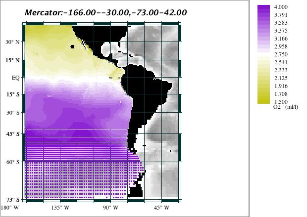
5 equator in the east Pacific Ocean. The highest 3 He concentration, %, was found along the P04 transect at a latitude of 9.500N and a longitude of W and a sigma-2 of By using the high 3 He sigma-2 range as a guide, integration plots of temperature, salinity, and oxygen were developed to determine if there was any large-scale patterns that might be associated with volcanic outgassing in the waters of the east Pacific Ocean (Figure 5A-C). The integration plot for temperature has the most obvious trend along the East Pacific Rise; there appears to be a slight temperature increase in the water column of about.1 C directly above the East Pacific Rise (Figure 5A). The temperature variation is so apparent that one could easily trace the location of the East Pacific Rise for the majority of its length. A less clear trend exists in the salinity integration (Figure 5B). Within the high 3 He sigma-2 range, segments of the East Pacific Rise exhibit slightly depressed salinity values about.03 psu lower than the surrounding waters. The lowest salinity depressions occur in three localized regions. The Oxygen integration (Figure 5C) shows no clear trend related to the East Pacific Rise, but an apparent trend of high Oxygen in the southern Pacific Ocean at depth with increasing lower Oxygen concentrations toward the north. Conclusions and Discussions The highest 3 He concentration plume found along the P04 transect at latitude of 9.500N and longitude of W, occurs directly above an apex in the bathymetry. Based on the shape of the plume above the apex, it appears the apex might be the vent of the plume (Figure 3A). This hypothesis is confirmed; according to the USGS database of worldwide active volcanoes, an unnamed submarine volcano exists at latitude of 9.83N and longitude of W (
6 By examining the spatial relationships of the four transects and the locations of high 3 He within each transect, hypotheses regarding the extent of high 3He plumes were made. There appears to be plume extensions tapering to lower concentrations to the west at about latitudes 9 N, and 8 S, but at 30 S there appears to be a plume tapering to the east. The tapering affect seen in these plumes may be the result of at depth circulation carrying waters high in 3He away from their source. The proposed westward circulation at 9 N, and 8 S and the proposed eastward circulation at 30 S consistent are with the Pacific Ocean geostrophic circulation at 2000 and 2500 dbar in Reid (1997). The temperature and salinity variations noted in the WOA05 integration plots are skewed and the observed patterns seen above the East Pacific Rise may not be present in the steady state of the ocean. Because the integration calculations made were with respect to the high 3 He sigma- 2 range of 36.7 to 37.0 and at a sigma-2 value of 37.0 bathymetry along the East Pacific Rise prevents data collection, the final result which was plotted is biased toward the temperature, salinity, and Oxygen measurements taken at a sigma-2 value of A slight variation in the temperature and salinity of the waters above the East Pacific Rise may still be present but cannot be constrained in the datasets used in this study. The observed trend seen in the Oxygen integration high in the southern Pacific Ocean and lower in the northern Pacific Ocean is consistent with the general understanding of Pacific Ocean overturning, currents, and residence time (Talley et al. 2011). Due to the lack of data publically available in the Gulf of California, no new 3 He concentration analyses were conducted. Furthermore, because the transects crossed the southern East Pacific Rise obliquely limited data is available to hypothesize about variation in volcanic activity along the ridge. As such, it is recommended that future research cruises follow the apex
7 of the East Pacific Rise from its conception in the southern Pacific Ocean into the Gulf of California to clearly define potential 3 He vents. Additionally, two cruises should be conducted that parallel the apex of the East Pacific Rise one to the west and one to the east to identify the extent of 3 He plumes, which may be indicative of circulation at depth. References Downes, S.M., Key, R.M., Orsi, A.H., Speer, K.G., Swift, J.H., 2012, Tracing Southwest Pacific Bottom Water Using Potential Vorticity and Helium-3, American Meteorological Society, Vol. 42, pp Reid, J.L, 1997, On the total geostrophic circulation of the Pacific Ocean: flow patterns, tracers, and transports, Progress in Oceanography, Vol 39, pp Talley, L.D., Pickard, G.L., Emery. W.J., Swift, J.H., 2011, Descriptive Physical Oceanography (Sixth Edition), Burlington, Massachusetts: Elsevier


8 Figures Figure 1: EPR PAR From: Figure 2: P04 P17 P18 P19

9 Figure 3: A: P04 B: P17 C: P18 D: P19 Figure 4:


10 Figure 5: P04 P17 P18 P19 Figure 6: A

11 B C
On the world-wide circulation of the deep water from the North Atlantic Ocean
 Journal of Marine Research, 63, 187 201, 2005 On the world-wide circulation of the deep water from the North Atlantic Ocean by Joseph L. Reid 1 ABSTRACT Above the deeper waters of the North Atlantic that
Bathymetric Maps and Plate Tectonics. CPO Science
 Bathymetric Maps and Plate Tectonics CPO Science Key Questions What is a bathymetric map? What is plate tectonics, and what are the chief tectonic plates of Earth s lithosphere? What will Earth s surface
12. The diagram below shows the collision of an oceanic plate and a continental plate.
 Review 1. Base your answer to the following question on the cross section below, which shows the boundary between two lithospheric plates. Point X is a location in the continental lithosphere. The depth
Dynamic Earth Quiz. 4. The accompanying diagram shows some features of Earth s crust and upper mantle.
 DO NOT WRITE ON THIS Dynamic Earth Quiz DO NOT WRITE ON THIS 1. Base your answer(s) to the following question(s) on the diagram below. The diagram shows a model of the relationship between Earth s surface
Earth s Tectonic Plates
 MASTER 49 6.2 3.7 5.4 Philippine Pacific 5.4 North American Juan de Fuca Caribbean Cocos 10.0 9.2 2.3 2.5 2.3 1.8 3.0 Indian-Australian 10.5 7.1 17.2 16.8 6.0 Nazca South American 11.1 10.3 7.3 3.7 7.5
Kind of plate boundary (convergent or divergent?)
") 19B Plate Tectonics What is plate tectonics? Earth s crust plus the upper mantle forms the lithosphere. Earth s lithosphere is broken in a number of different pieces. How these pieces move and interact
19B Plate Tectonics What is plate tectonics? Earth s crust plus the upper mantle forms the lithosphere. Earth s lithosphere is broken in a number of different pieces. How these pieces move and interact
Ocean Sciences 101 The Marine Environment OCEA 101 THE MARINE ENVIRONMENT MID-TERM EXAM
 OCEA 101 THE MARINE ENVIRONMENT MID-TERM EXAM Part I. Multiple Choice Questions. Choose the one best answer from the list, and write the letter legibly in the blank to the left of the question. 2 points
Crustal Boundaries. As they move across the asthenosphere and form plate boundaries they interact in various ways. Convergent Transform Divergent
 Name: Date: Period: Plate Tectonics The Physical Setting: Earth Science CLASS NOTES Tectonic plates are constantly moving and interacting As they move across the asthenosphere and form plate boundaries
Earth / Environmental Science. Ch. 14 THE OCEAN FLOOR
 Earth / Environmental Science Ch. 14 THE OCEAN FLOOR The Blue Planet Nearly 70% of the Earth s surface is covered by the global ocean It was not until the 1800s that the ocean became an important focus
Practice Questions: Plate Tectonics
 Practice Questions: Plate Tectonics 1. Base your answer to the following question on The block diagram below shows the boundary between two tectonic plates. Which type of plate boundary is shown? A) divergent
Module 7: Plate Tectonics and Earth's Structure Topic 2 Content: Plates of the World Presentation Notes
 There are several large plates and several smaller plates that comprise the Earth s crust. How do these plates interact with the bordering plates? Review each of the world s plates and the landforms that
Seafloor Spreading and Paleomagnetism Activity
 Name: PART A: Ocean Bottom Profile Background: Seafloor spreading is the hypothesis that the sea floor moves sideways away from the crest of the mid- ocean ridge. It is estimated that 20 volcanic eruptions
Crustal Activity. Plate Tectonics - Plates - Lithosphere - Asthenosphere - Earth s surface consists of a major plates and some minor ones
 Name: Date: Period: Tectonics The Physical Setting: Earth Science CLASS NOTES Tectonics - s - Lithosphere - Asthenosphere - Earth s surface consists of a major plates and some minor ones The plates are
An Introduction to the Seafloor and Plate Tectonics 1
 An Introduction to the Seafloor and Plate Tectonics 1 Objectives 1) Investigate the components of the lithosphere and lithospheric plates. 2) Identify the associations among various seafloor features,
Plate Tectonics: The New Paradigm
 Earth s major plates Plate Tectonics: The New Paradigm Associated with Earth's strong, rigid outer layer: Known as the lithosphere Consists of uppermost mantle and overlying crust Overlies a weaker region
6. In the diagram below, letters A and B represent locations near the edge of a continent.
 1. Base your answer to the following question on the cross section below and on your knowledge of Earth science. The cross section represents the distance and age of ocean-floor bedrock found on both sides
Earth and Space Science Semester 2 Exam Review. Part 1. - Convection currents circulate in the Asthenosphere located in the Upper Mantle.
 Earth and Space Science 2015 Semester 2 Exam Review Part 1 Convection -A form of heat transfer. - Convection currents circulate in the Asthenosphere located in the Upper Mantle. - Source of heat is from
MARINE GEOLOGY & GEOGRAPHY
 MARINE GEOLOGY MARINE GEOLOGY & GEOGRAPHY Marine Geology 4 LAYERS OF THE EARTH CRUST THICKNESS: VARIES BETWEEN OCEAN & CONTINENTS 5-40 KM STATE: SOLID ELEMENTS: SILICON, ALUMINUM, CALCIUM, SODIUM, POTASSIUM
A) B) C) D) 4. Which diagram below best represents the pattern of magnetic orientation in the seafloor on the west (left) side of the ocean ridge?
 B) C) D) 4. Which diagram below best represents the pattern of magnetic orientation in the seafloor on the west (left) side of the ocean ridge?") 1. Crustal formation, which may cause the widening of an ocean, is most likely occurring at the boundary between the A) African Plate and the Eurasian Plate B) Pacific Plate and the Philippine Plate C)
1. Crustal formation, which may cause the widening of an ocean, is most likely occurring at the boundary between the A) African Plate and the Eurasian Plate B) Pacific Plate and the Philippine Plate C)
Geography of the world s oceans and major current systems. Lecture 2
 Geography of the world s oceans and major current systems Lecture 2 WHY is the GEOMORPHOLOGY OF THE OCEAN FLOOR important? (in the context of Oceanography) WHY is the GEOMORPHOLOGY OF THE OCEAN FLOOR important?
1. Name at least one place that the mid-atlantic Ridge is exposed above sea level.
 Interpreting Tectonic and Bathymetric Maps. The purpose of this lab is to provide experience interpreting the bathymetry of the seafloor in terms of tectonic and geologic settings and processes. Use the
Laboratory #7: Plate Tectonics
 Materials Needed: 1. Pencil 2. Colored Pencils 3. Metric/Standard Ruler 4. Calculator 5. Tracing Paper Laboratory #7: Plate Tectonics Plate Tectonics The Earth is composed of layers. At the center is a
Comparison of the Siberian shelf seas in the Arctic Ocean
 Comparison of the Siberian shelf seas in the Arctic Ocean by Audun Scheide & Marit Muren SIO 210 - Introduction to Physical Oceanography November 2014 Acknowledgements Special thanks to James Swift for
Results of oceanographic analyses conducted under JARPA and JARPAII and possible evidence of environmental changes
 Results of oceanographic analyses conducted under JARPA and JARPAII and possible evidence of environmental changes Tomowo WATANABE 1, MAKOTO OKAZAKI 1 AND KOJI MATSUOKA 2 1 National Research Institute
General Oceanography Geology 105 Expedition 8 Plate Boundaries Beneath the Sea
 General Oceanography Geology 105 Expedition 8 Plate Boundaries Beneath the Sea Name Not attempting to answer questions on expeditions will result in point deductions on course workbook (two or more blank
Dynamic Crust Practice
 1. Base your answer to the following question on the cross section below and on your knowledge of Earth science. The cross section represents the distance and age of ocean-floor bedrock found on both sides
Geologic Evolution of Latin America. Plate Tectonics: General Concepts & Applications to Latin America
 Geologic Evolution of Latin America Plate Tectonics: General Concepts & Applications to Latin America Structure of Earth: 3 major divisions of Core, Mantle, and Crust Upper mantle differs in the way that
is a unifying theme in modern geology that integrates the earlier ideas of
 The concept of Global Plate Tectonics is a unifying theme in modern geology that integrates the earlier ideas of continental drift, sea-floor spread, and mountain building To explain why the present ocean
The Four Layers The Earth is composed of four different layers. The crust is the layer that you live on, and it is the most widely studied and
 Earth s Structure The Four Layers The Earth is composed of four different layers. The crust is the layer that you live on, and it is the most widely studied and understood. The mantle is much hotter and
TAKE HOME EXAM 8R - Geology
 Name Period Date TAKE HOME EXAM 8R - Geology PART 1 - Multiple Choice 1. A volcanic cone made up of alternating layers of lava and rock particles is a cone. a. cinder b. lava c. shield d. composite 2.
Chapter 7 Plate Tectonics. Plate tectonics accounts for important features of Earth s surface and major geologic events.
 Chapter 7 Plate Tectonics Plate tectonics accounts for important features of Earth s surface and major geologic events. 7-2 Alfred Wegener s Hypothesis of Continental Drift (1915) ONE single landmass
Diagram 1. Diagram What kind of crust is plate A, B and C made of? 2. What type of plate boundary is shown at X?
 Diagram 1 1. What kind of crust is plate A, B and C made of? 2. What type of plate boundary is shown at X? 3. What plate boundary is shown at Y? 4. What is being shown at Z? Why is plate B going underneath
GLG 103: The Way the Earth Works: Examining Plate Tectonics Lab. Watch the video, Exploring the Geosphere: Visions of Earth
 GLG 103: The Way the Earth Works: Examining Plate Tectonics Lab Name Watch the video, Exploring the Geosphere: Visions of Earth. Staple your second set of definitions, the matching not the completion,
The Ocean Floor THE VAST WORLD OCEAN
 OCEANOGRAPHY Name Color all water LIGHT BLUE. Color all land LIGHT GREEN. Label the 5 Oceans: Pacific, Atlantic, Indian, Arctic, Antarctic. Label the 7 Continents: N.America, S.America, Europe, Asia, Africa,
Plates Moving Apart Types of Boundaries
 Plates Moving Apart Types of Boundaries PLATE TECTONICS IS The theory that the Earth s crust is broken into slabs of rock that move around on top of the asthenosphere. How fast are plates moving? The Arctic
Lab 1: Plate Tectonics April 2, 2009
 Name: Lab 1: Plate Tectonics April 2, 2009 Objective: Students will be introduced to the theory of plate tectonics and different styles of plate margins and interactions. Introduction The planet can be
Prentice Hall EARTH SCIENCE
 Prentice Hall EARTH SCIENCE Tarbuck Lutgens Chapter 9 Plate Tectonics 9.1 Continental Drift An Idea Before Its Time Wegener s continental drift hypothesis stated that the continents had once been joined
Prentice Hall EARTH SCIENCE
 Prentice Hall EARTH SCIENCE Tarbuck Lutgens Chapter 9 Plate Tectonics 9.1 Continental Drift An Idea Before Its Time Wegener s continental drift hypothesis stated that the continents had once been joined
Dynamic Earth A B1. Which type of plate boundary is located at the Jordan Fault? (1) divergent (3) convergent (2) subduction (4) transform
 divergent (3) convergent (2) subduction (4) transform") Dynamic Earth A B1 1. The edges of most lithospheric plates are characterized by (1) reversed magnetic orientation (2) unusually rapid radioactive decay (3) frequent volcanic activity (4) low P-wave and
Dynamic Earth A B1 1. The edges of most lithospheric plates are characterized by (1) reversed magnetic orientation (2) unusually rapid radioactive decay (3) frequent volcanic activity (4) low P-wave and
SUPPLEMENTARY INFORMATION
 In the format provided by the authors and unedited. SUPPLEMENTARY INFORMATION DOI: 10.1038/NGEO3053 1 2 Contribution of topographically-generated submesoscale turbulence to Southern Ocean overturning 3
Unit Topics. Topic 1: Earth s Interior Topic 2: Continental Drift Topic 3: Crustal Activity Topic 4: Crustal Boundaries Topic 5: Earthquakes
 The Dynamic Earth Unit Topics Topic 1: Earth s Interior Topic 2: Continental Drift Topic 3: Crustal Activity Topic 4: Crustal Boundaries Topic 5: Earthquakes Topic 1: Earth s Interior Essential Question:
Evidence from the Surface. Chapter 02. Continental Drift. Fossil Evidence for Pangaea. Seafloor Spreading. Seafloor Spreading 1/31/2012
 Evidence from the Surface Surface landforms Continental shelf and slope Abyssal Plane Mid-oceanic ridge Oceanic Trenches Chapter 02 Continental Drift Continental Drift - a hypothesis that the continents
Chapter 2 Plate Tectonics and the Ocean Floor
 Chapter 2 Plate Tectonics and the Ocean Floor Matching. Match the term or person with the appropriate phrase. You may use each answer once, more than once or not at all. 1. hydrothermal vents A. convergent
General Oceanography Geology 105 Expedition 8 Plate Boundaries Beneath the Sea Complete by Thursday at 11:00 PM
 General Oceanography Geology 105 Expedition 8 Plate Boundaries Beneath the Sea Complete by Thursday at 11:00 PM Name Expedition Objectives Learn about the types of plate boundaries and their key characteristics
MARINE GEOLOGY & GEOGRAPHY
 MARINE GEOLOGY & GEOGRAPHY Bathymetry BATHYMETRY BATHYMETRY THE UNDERWATER EQUIVALENT TO TOPOGRAPHY THE STUDY OF WATER DEPTH A BATHYMETRIC MAP SHOWS FLOOR RELIEF OR TERRAIN AS CONTOUR LINES Bathymetry
Marine Science and Oceanography
 Marine Science and Oceanography Marine geology- study of the ocean floor Physical oceanography- study of waves, currents, and tides Marine biology study of nature and distribution of marine organisms Chemical
OS 1 The Oceans Fall 2007
 Name: Plate Tectonics (you must turn Activities 1-2 in during Section) Activity 1: Plate Boundaries A plate boundary simply describes where two plates (either oceanic or continental material) meet. There
Ocean and Climate I.
 Ocean and Climate I http://www.gerhardriessbeck.de/ Physical Characteristics of the Ocean Surface area: 3.61 10 14 m 2 Mean depth: 3.7 km Ocean volume: 3.2 10 17 m 3 Mean density: 1.035 10 3 kg/m 3 Ocean
Earthquakes. Earthquakes are caused by a sudden release of energy
 Earthquakes Earthquakes are caused by a sudden release of energy The amount of energy released determines the magnitude of the earthquake Seismic waves carry the energy away from its origin Fig. 18.1 Origin
Plate Tectonics. How do the plates move?
 Plate Tectonics How do the plates move? Continental Drift Hypothesis In 1915, Alfred Wegener s hypothesis about Continental Drift couldn t explain the forces that could move continents. Wegener wasn t
USU 1360 TECTONICS / PROCESSES
 USU 1360 TECTONICS / PROCESSES Observe the world map and each enlargement Pacific Northwest Tibet South America Japan 03.00.a1 South Atlantic Arabian Peninsula Observe features near the Pacific Northwest
PROCESSING RECORD SCRIPPS INSTITUTION OF OCEANOGRAPHY ARCHIVES. Physical Description: 13 mss, ½ mss, 1 shoe box, 1 card box, oversize, slides
 Accession No.: 2008-17 PROCESSING RECORD SCRIPPS INSTITUTION OF OCEANOGRAPHY ARCHIVES Tsuchiya, Mizuki 1929-2010 Mizuki Tsuchiya Papers, 1962-2004 Physical Description: 13 mss, ½ mss, 1 shoe box, 1 card
8 th Grade Science Plate Tectonics and Topography Review
 8 th Grade Science Plate Tectonics and Topography Review #1 Scientists believe that the land masses of Earth were once joined together as one supercontinent called. A: Australia B: Wegner C: Pangaea D:
Section 21.1 pp What is Climate?
 Section 21.1 pp. 466 468 What is Climate? Set a Purpose: TE, p. 466 Reading Study Guide, p. 73 More about How Climate Controls Interact TE, p. 466 Differentiating ion Reading Support: TE, p. 466 Critical
EPSS 15. Spring Introduction to Oceanography. Laboratory #1 Maps, Cross-sections, Vertical Exaggeration, Graphs, and Contour Skills 4/7/17
 EPSS 15 Spring 2017 Introduction to Oceanography Laboratory #1 Maps, Cross-sections, Vertical Exaggeration, Graphs, and Contour Skills MAPS Provide valuable interface to explore the geography of the world
Earth Dynamics. Landforms at Plate Boundaries
 Earth Dynamics CHAPTER 8 LESSON 2 Landforms at Boundaries What do you think? Read the two statements below and decide whether you agree or disagree with them. Place an A in the Before column if you agree
WOCE P19 in the Eastern South Pacific. Acknowledgements. References
 silicate values might originate from western Caroline Basin through the sill of the Kyushu-Palau Ridge near 4 N and 5 N. Acknowledgements The authors thank all participants of this cruise and Captain Tanaka
Introduction to the Seafloor. Follow the steps below while taking notes in your science notebook.
 Procedure Follow the steps below while taking notes in your science notebook. 1. Name and locate all of the continents. 2. Identify linear (straight-line) and arcuate (curved-line) features on the continents.
Layer Composition Thickness State of Matter
 Unit 4.2 Test Review Earth and Its Layers 1. Label the layers of the earth. oceanic crust continental crust lithosphere asthenosphere mantle outer core inner core 2. Complete the Following Table about
Map shows 3 main features of ocean floor
 Map shows 3 main features of ocean floor 2017 Pearson Education, Inc. Chapter 3 Marine Provinces 2017 Pearson Education, Inc. 1 Chapter 3 Overview The study of bathymetry determines ocean depths and ocean
Directed Reading. Section: The Theory of Plate Tectonics. to the development of plate tectonics, developed? HOW CONTINENTS MOVE
 Skills Worksheet Directed Reading Section: The Theory of Plate Tectonics 1. The theory that explains why and how continents move is called. 2. By what time period was evidence supporting continental drift,
Inside Earth Review Packet
 1. The slow movement of the continents across the Earth s surface is defined as - A Newton s 1 st Law of Motion B Continental Drift C Law of Transformation of Energy D Earth s movement 2. The scientist
Plate Tectonic Vocabulary Chapter 10 Pages
 Name: Period: Plate Tectonic Vocabulary Chapter 10 Pages 239-260 Vocabulary Word What is this? What are some examples? What does it look like? (draw a picture or diagram) Continental drift Mid-ocean ridge
In 1912 Alfred Wegener proposed Continental Drift the continents have moved over time the continents were part of one giant landmass named Pangaea.
 Plate Tectonics In 1912 Alfred Wegener proposed Continental Drift the continents have moved over time the continents were part of one giant landmass named Pangaea. Pangaea Landmass movements over millions
1. List the 3 main layers of Earth from the most dense to the least dense.
 1. List the 3 main layers of Earth from the most dense to the least dense. 2. List the 6 layers of earth based on their physical properties from the least dense to the most dense. 3. The thinnest layer
* If occurs, fossils that formed in shallow water may be found in water. Subsidence mean the crust is.
 Name Notes: Topic 5B Topic 5B: The Dynamic Crust A. What evidence exists that proves the Earth s Crust is and has moved? Earth Science 1. Tilted, folded or faulted strata Strata is a term that refers to.
Continental Drift. Wegener theory that the crustal plates are moving and once were a super continent called Pangaea.
 PLATE TECTONICS WHAT IS TECTONICS? Tectonism is the faulting or folding or other deformation of the outer layer of a planet. It happens very slowly, on the scale of millions of years. Tectonic activity
1. What is Wegener s theory of continental drift? 2. What were the 4 evidences supporting his theory? 3. Why wasn t Wegener s theory excepted?
 Notebook 7a and 7b Objective (left-side): Students will be able to explain the theory of plate tectonics and be able to make predictions about plate interactions. Mapping Reflection 1. What is Wegener
2. Add the numbers in both columns of Summary Table. The total should equal the Total number of Quakes.
 Subduction lab Name Period Date The vast majority of earthquakes occur at plate boundaries. The deepest earthquakes occur at subduction boundaries where lithosphere is plunging down into the mantle. Deep
Plate Tectonics AGS 371
 Name(s) Date Period Instructions Plate Tectonics AGS 371 This lab utilizes the CD The Theory of Plate Tectonics (Advanced). The lab consists of a number of questions and diagrams regarding the development
83% 25 of 30 Correct. Dynamic Earth Assessment Test Results. Name: Marc Sto. Domingo Date: October 2, 2013
 Dynamic Earth Assessment Test Results Name: Marc Sto. Domingo Date: October 2, 2013 83% 25 of 30 Correct Review the questions and your answers below. The answer you selected is highlighted in red, the
Chapter 2: Plate Tectonics: A Unifying Theory
 Chapter 2: Plate Tectonics: A Unifying Theory Chapter Outline 2.1 Introduction 2.2 Early Ideas About Continental Drift 2.3 What Is the Evidence for Continental Drift? 2.4 Features of the Seafloor 2.5 Earth
The Indian Ocean. Copyright 2010 LessonSnips
 The Indian Ocean One of the five major geographic divisions of the world s ocean, the Indian Ocean is located in the Eastern Hemisphere. The Indian Ocean is bounded by three continents: Africa to the west,
Full file at
 Essentials of Oceanography, 10e (Trujillo/Keller) Chapter 2 Plate Tectonics and the Ocean Floor Match the term with the appropriate phrase. You may use each answer once, more than once or not at all. A)
Plate Tectonics Practice Test
 Plate Tectonics Practice Test 1. What is the main idea Alfred Wegner proposed in the Theory of Continental Drift that he published in 1915? a. The continents float on a liquid layer that allows them to
Lab 9: Satellite Geodesy (35 points)
") Lab 9: Satellite Geodesy (35 points) Here you will work with GPS Time Series data to explore plate motion and deformation in California. This lab modifies an exercise found here: http://www.unavco.org:8080/cws/pbonucleus/draftresources/sanandreas/
Lab 9: Satellite Geodesy (35 points) Here you will work with GPS Time Series data to explore plate motion and deformation in California. This lab modifies an exercise found here: http://www.unavco.org:8080/cws/pbonucleus/draftresources/sanandreas/
Shape of the seafloor. Shape of the seafloor. Shape of the seafloor. Shape of the seafloor. Shape of the seafloor. Shape of the seafloor
 Multibeam echo sounders - Research vessel Scripps Institution of Oceanography R/V Roger Revelle depth Source: Scripps Institution of Oceanography http://woodshole.er.usgs.gov/project-pages/caribbean/movie1.html
Plate Tectonics. What is a theory? What is a fact? In science, a theory is an explana4on, with evidence, that can be tested.
 What is a theory? Plate Tectonics In science, a theory is an explana4on, with evidence, that can be tested. What is a fact? Informa4on that cannot be argued. Plate Tectonics Plate Tectonics The theory
The Structure of the Earth and Plate Tectonics
 The Structure of the Earth and Plate Tectonics Agree or Disagree? 1. The Earth if made up of 4 different layers. 2. The crust (where we live) can be made of either less dense continental crust or the more
Learning Assessment #1 Plate Tectonics Reid, L.F., Cowie, B.R. (2011) Department of Geoscience, University of Calgary
 Department of Geoscience, University of Calgary") Learning Assessment #1 Plate Tectonics Reid, L.F., Cowie, B.R. (2011) Department of Geoscience, University of Calgary This assignment is the first of a series of in-class activities known as learning assessments.
Learning Assessment #1 Plate Tectonics Reid, L.F., Cowie, B.R. (2011) Department of Geoscience, University of Calgary This assignment is the first of a series of in-class activities known as learning assessments.
Earth s Continents and Seafloors. GEOL100 Physical Geology Ray Rector - Instructor
 Earth s Continents and Seafloors GEOL100 Physical Geology Ray Rector - Instructor OCEAN BASINS and CONTINENTAL PLATFORMS Key Concepts I. Earth s rocky surface covered by of two types of crust Dense, thin,
UNIT 11 PLATE TECTONICS
 UNIT 11 PLATE TECTONICS A. ALFRED WEGENER 1. Continental drift hypothesis Single supercontinent called Pangaea 200 million years ago Pangaea (all land) began to break up and started drifting to their present
1. The figure shows sea surface height (SSH) anomaly at 24 S (southern hemisphere), from a satellite altimeter.
 anomaly at 24 S (southern hemisphere), from a satellite altimeter.") SIO 210 Problem Set 3 November 16, 2015 1. The figure shows sea surface height (SSH) anomaly at 24 S (southern hemisphere), from a satellite altimeter. (a) What is the name of this type of data display?_hovmöller
SIO 210 Problem Set 3 November 16, 2015 1. The figure shows sea surface height (SSH) anomaly at 24 S (southern hemisphere), from a satellite altimeter. (a) What is the name of this type of data display?_hovmöller
Unit 11: Plate Tectonics
 Unit 11: Plate Tectonics A. Alfred Wegner 1. Continental drift hypothesis a. single supercontinent called Pangaea b. 200 million years ago Pangaea (all land) began to break up and started drifting to their
Plate Tectonics: A Unifying Theory
 Plate Tectonics: A Unifying Theory What is Plate Tectonics? - 7 large tectonic plates and many smaller ones that break up the lithosphere - Plates are brittle and float on asthenosphere and glide past
2. Explain why there are these two predominate elevations. (Hint: think about isostasy and the type of materials we used to demonstrate buoyancy).
.") IDS 102 Plate Tectonics Questions Part I: Observations- Four maps of world are positioned around the room. Answer the questions associated with each map and record your general observations about the maps.
IDS 102 Plate Tectonics Questions Part I: Observations- Four maps of world are positioned around the room. Answer the questions associated with each map and record your general observations about the maps.
SIO 210: Data analysis
 SIO 210: Data analysis 1. Sampling and error 2. Basic statistical concepts 3. Time series analysis 4. Mapping 5. Filtering 6. Space-time data 7. Water mass analysis 10/8/18 Reading: DPO Chapter 6 Look
Cruise and Data Report: R/V Shana Rae operations in support of April 2015 AirSWOT campaign, April 17-20, 2015
 Cruise and Data Report: R/V Shana Rae operations in support of April 2015 AirSWOT campaign, April 17-20, 2015 J. Thomas Farrar, Benjamin Hodges, Sebastien Bigorre Physical Oceanography Department Woods
Science 10 PROVINCIAL EXAM STUDY BOOKLET. Unit 4. Earth Science
 Science 10 PROVNCAL EXAM STUDY BOOKLET Unit 4 Earth Science Student nstructions 1. Ensure that you have blank paper and a Data Booklet. 2. Record all answers on a separate piece of paper. 3. Answer keys
SIO 210: Data analysis methods L. Talley, Fall Sampling and error 2. Basic statistical concepts 3. Time series analysis
 SIO 210: Data analysis methods L. Talley, Fall 2016 1. Sampling and error 2. Basic statistical concepts 3. Time series analysis 4. Mapping 5. Filtering 6. Space-time data 7. Water mass analysis Reading:
Chapter. Graphics by Tasa Graphic Arts. Inc.
 Earth Chapter Plate Science 9 Tectonics Graphics by Tasa Graphic Arts. Inc. 1 I. Earth s surface is made up of lithospheric plates. A. Lithospheric plates are composed of the crust and part of the upper
Ch 9.1 Notes. Objective: Be able to explain the theory of plate tectonics and be able to explain evidence that supports it.
 Ch 9.1 Notes Objective: Be able to explain the theory of plate tectonics and be able to explain evidence that supports it. Pangaea Alfred Wegener proposed that land on Earth formed a single, huge landmass.
Chapter Overview. Bathymetry. Measuring Bathymetry. Measuring Bathymetry
 CHAPTER 3 Marine Provinces Chapter Overview The study of bathymetry determines ocean depths and ocean floor topography. Echo sounding and satellites are efficient bathymetric tools. Most ocean floor features
Size matters: another reason why the Atlantic is saltier than the Pacific C.S. Jones and Paola Cessi
 Size matters: another reason why the Atlantic is saltier than the Pacific C.S. Jones and Paola Cessi Scripps Institution of Oceanography University of California, San Diego Proposed reasons for Atlantic
In order to study Plate Tectonics, we must first
 TB Chapter 13 In order to study Plate Tectonics, we must first reorganize our layering system for the Earth: Old System 4 layers Crust (rigid) id) (rigid) Mantle (putty like) (semi rigid) Outer core (liquid)
Tectonic Forces Simulation: Volcanoes Activity One
 Tectonic Forces Simulation: Volcanoes Activity One Introduction Volcanoes form above vents or cracks in the earth's crust. When a volcano erupts, magma is forced up through the cracks - sending lava, ash,
Oceanography is the scientific study of oceans Oceans make up over 70% of the Earth s surface
 Oceanography Oceanography is the scientific study of oceans Oceans make up over 70% of the Earth s surface An ocean must be large and have features which set it apart from other oceans (currents, water
Name Class Date. Write the letter that best answers the question or completes the statement on the line provided.
 Chapter 1 Introduction to Earth Science Chapter Study Guide Multiple Choice Write the letter that best answers the question or completes the statement on the line provided. 1. Which of the following is
Plate Tectonics. Essentials of Geology, 11 th edition Chapter 15
 1 Plate Tectonics Essentials of Geology, 11 th edition Chapter 15 2 3 4 5 6 7 8 9 10 11 12 13 14 15 Plate Tectonics: summary in haiku form Alfred Wegener gave us Continental Drift. Fifty years later...
Laboratory #1: Plate Tectonics
 Name: Lab day: Tuesday Wednesday Thursday ENVG /SC 10110-20110L Planet Earth Laboratory Laboratory #1: Plate Tectonics Readings: http://www.nd.edu/~cneal/physicalgeo/lab8/pt-lab-manual.pdf. Tools needed