SUBSIDENCE MONITORING AS KEY FACTOR FOR ENVIRONMENTAL SUSTAINABILITY OF THE OIL AND GAS PROJECTS
|
|
|
- Lizbeth McBride
- 6 years ago
- Views:
Transcription

1 SUBSIDENCE MONITORING AS KEY FACTOR FOR ENVIRONMENTAL SUSTAINABILITY OF THE OIL AND GAS PROJECTS Fabio Casolini e Francesco Italiano, Eni E&P Bologna, 12 giugno

2 SUBSIDENCE it is a slow and progressive vertical lowering of the earth surface due to various factors Two main types: natural: during burial of rocks, the weight of the overlying materials reduce pore volume and causes compaction. Induced: the extraction of fluids from the ground decreases the pore pressure, increases the effective stress with a consequent compaction of the soil. Subsidence at the surface Compacation of producing reservoir 2
3 COMPACTION AND SUBSIDENCE THEORY Terzaghi s principle of effective stress σ = σ - p σ = totale vertical stress = overburden gradient x depth σ = effective vertical stress p = pore pressure Reservoir pore-pressure Effective stress Compaction Subsidence All measurable effects of a change of stress, such as compression, distorsion and a change of shearing resistance, are exclusively due to changes in the effective stress K. Terzaghi,


4 TEAMS FOCUSED ON GEODYNAMICS IN ENI E&P Geodynamics operations ITALIA 3 persons Geomechanical models 10 persons Geodynamic monitoring 8 persons Mission: prevention, mitigation and monitoring of geodynamic phenomena of the territory, with particular attention to issues of integration with the preservation and protection of territory, its economy and its environmental equilibrium. 4


5 UNIVERSITIES AND RESEARCH CENTERS For all geodynamic subjects Eni collaborates with agencies, universities and research centers, national and international, to develop and maintain an excellent level of know-how and skills. University of Bologna University of Torino University of Padua Deltares, Netherlands University of Ferrara Tele-rilevemento Europa University of Urbino Stanford University, USA Italian National Institute of Geophysics and Volcanology 5

6 6


7 Main causes of erosion and marine ingression: 1. decrease in sand transportation from rivers; 2. lowering of ground due to anthropogenic and natural subsidence; 3. presence of harbors, jetties, breakwaters, groynes that modify sediment transport along the coast; 4. destruction of coastal dunes that formed, as well as a natural protection, the natural reservoir of sand. 7


8 PREVISION AND CONTROL OF SUBSIDENCE In a program of prevision and control of subsidence, three basic actions of intervention can be defined : 1. prediction of subsidence in the area affected by the phenomenon using mathematical and numerical models; 2. establishment of a monitoring program; PROBABILITY CONSEQUENCES 3. prevention of the expected subsidence or mitigation of observed subsidence during field production. 8

9 GUIDELINES PUBLISHED BY UNIVERSITY OF PADUA 9
10 MONITORINGS Shallow: optical levelling; permanent installations of continuos GPS; interferometry on SAR satellite images; extensimeters; piezometers; LiDAR survey (Laser Imaging Detection And Ranging); batymetric surveys (transepts, multibeam, LADS, etc.). Deep: deep compaction survey with radioactive markers; deep monitoring of static pression in the reservoir; microsismic monitoring. Validation of the metodologies and results: levelling -> University of Bologna Civil Engineering Dpt.; CGPS -> University of Bologna Phisic Dpt. 10


11 Levelling DIFFERENCES OF HEIGHT Accuracy 1 mm/km CGPS Accuracy ~ 1 mm/y InSAR Accuracy ~ 1mm/y LiDAR Digital DEM Accuratezza cm Multi-beam Digital DEM Accuracy ~20 cm Reservoir Compaction Measuring the distance Between radioactive markers Accuratezza 2 3 mm SHALLOW ACQUIFER Shallow compaction UP TO DEPTH m accuracy 0,5 mm Piezometers UP TO DEPTH m DEEP ACQUIFER CAP ROCK RESERVOIR 11
12 OPTICAL LEVELLING 12

13 OPTICAL LEVELLING: ENI NETWORK Tot. Totale 1822 km km di livellazione:
14 PERMANENT GPS 14

15 CGPS: ENI NETWORK 15
16 PERMANENT GPS: ENI NETWORK 18 numero stazioni The GPS network is composed by 66 stations, 45 offshore e 21 onshore. 16

17 CGPS RECORDING mm/y 17
18 InSAR 18

19 INTERFEROMETRY ANALYSIS OF SAR SATELLITE IMAGES WITH PSINSAR TM 19

20 AREA COVERED ERS ENVISAT COPERTURA IMMAGINI ERS km 2 RADARSAT ENVISAT km 2 RADARSAT km 2 20
21 ESTENSIMETERS AND PIEZOMETERS 21

22 EXTENSIMETER/PIEZOMETER STATIONS dal 1994 dal 1998 dal
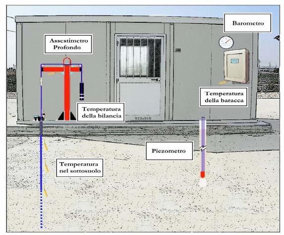


23 EXTENSIMETER/PIEZOMETER STATIONS To obtain informations necessary for the determination of the shallow compaction. 23
24 DATA MONITORING INTEGRATION Reliability and quality of subsidence monitoring is strongly improved combining the three technique: 1. optical levelling; 2. permanent GPS; 3. InSAR. Data collected by extensimeter/piezometer help to evaluate different components of the recorded subsidence: 1. natural subsidence; 2. subsidence due to water pumping. 24
25 BATHYMETRIC SURVEYS 25

26 BATHYMETRIC SURVEYS Angela km 2 Regina km 2 Clara complex km 2 Annamaria km 2 Bonaccia km 2 Guendalina km 2 transept LADS sottocosta km 2 Full coverage surveys: Multibeam LADS - laser airborne depth sounder 26
27 LIDAR 27


28 AIRBORNE ALTIMETRIC LIDAR Area covered: 322 km 2 of coast from Rimini to mouth of Po river Goal: build DSM and DTM to evaluate the soil compaction due to the presence of buildings. 28
29 MICROSEISMIC 29
 6 stations 16 on-shore stations 2 off-shore stations")
30 MICROSEISMIC MONITORING Actual network: Val d Agri (from 2001) 12 stations Crotone (from 2003) 6 stations 16 on-shore stations 2 off-shore stations 30
31 MARINE METEOROLOGICAL MONITORING 31

32 MARINE METEOROLOGICAL MONITORING 5 STATIONS Variables acquired: current wave height sea temperature atmospheric temperature atmospheric pressure air humidity solar radiation wind direction wind speed The measurements are sampled and stored every 30 minutes. 32
33 MARKERS 33


34 SURVEYS OF DEEP COMPACTION USING MARKERS markers gamma ray tool (FSMT/CMI) 34

35 WELLS EQUIPPED WITH MARKER 35
36 SUBSIDENCE MODEL CALIBRATION 36
37 MODEL CALIBRATION WITH CGPS AND LEVELLING 37


38 SUBSIDENCE MODEL CALIBRATION WITH BATHYMETRY A / C A / C B B anomaly in 2D anomaly in 3D 38

39 SUBSIDENCE MODEL CALIBRATION WITH BATHYMETRY model bathymetry Previsional Model bathymetry Max subs ca. 95 cm Max anomaly Coast distance of -2cm ca. 11,5 km ca. 80 cm ca. 11,5 km 39
40 CONCLUSIONS MONITORING DATA COLLECTED DURING FIELD PRODUCTION ALLOW TO CALIBRATE AND UPDATE PREVISIONAL STUDIES OF SUBSIDENCE AND GIVE THE POSSIBILITY TO TAKE ANY NECESSARY ACTION OF CONTROL AND/OR MITIGATION OF THE PROBLEM TO PROTECT AND SAFEGUARD THE TERRITORY AND ITS ECONOMY. 40

41 MANY THANKS FOR YOUR ATTENTION 41
Pilot service: Southern Emilia Romagna (Italy)
") Pilot service: Southern Emilia Romagna (Italy) Surface deformation service provider (PSInSAR TM ) Geodetic and optical remote sensing data integration Final user The study area The Southern Emilia-Romagna
Pilot service: Southern Emilia Romagna (Italy) Surface deformation service provider (PSInSAR TM ) Geodetic and optical remote sensing data integration Final user The study area The Southern Emilia-Romagna
Quantitative assessment of natural and anthropogenic land subsidence in oil and gas productive areas: issues and prospects in Italy.
 Quantitative assessment of natural and anthropogenic land subsidence in oil and gas productive areas: issues and prospects in Italy Valerio Comerci All information are publicly available at: Environmental
Department of National Defence B-Jetty Reconstruction
 Department of National Defence B-Jetty Reconstruction CFB Esquimalt, BC Presented by: Stantec & Golder Associates February 2, 2016 Agenda 1 B-Jetty Project Background 2 Distinguishing Project Features
SHORELINE AND BEACH PROCESSES: PART 2. Implications for Coastal Engineering
 SHORELINE AND BEACH PROCESSES: PART 2 Implications for Coastal Engineering Objectives of the lecture: Part 2 Show examples of coastal engineering Discuss the practical difficulties of ocean engineering
Geophysical Site Surveys
 Geophysical Site Surveys Simon Oakley Geoscience Team Leader Fugro Survey Limited 16/04/2014 Contents Menu Introduction Section 1 - Geophysical Site Surveys - Seabed Bathymetry - Shallow Geology - Seabed
Innovative Applications of Satellite Interferometry in the Oil&Gas Industry
 Innovative Applications of Satellite Interferometry in the Oil&Gas Industry A. Ferretti (1), G. Falorni (3), F. Novali (1), F. Rocca (2), A. Rucci (2), A. Tamburini (1) (1) Tele-Rilevamento Europa - TRE
Earth Observation in coastal zone MetOcean design criteria
 ESA Oil & Gas Workshop 2010 Earth Observation in coastal zone MetOcean design criteria Cees de Valk BMT ARGOSS Wind, wave and current design criteria geophysical process uncertainty modelling assumptions
The Arctic - A New Frontier The geological, environmental and engineering challenges for submarine telecommunication cables
 The Arctic - A New Frontier The geological, environmental and engineering challenges for submarine telecommunication cables Ryan Wopschall 5 September 2013 Oceanology International China, Shanghai Fugro
Integrated geological approach to the study of coastal subsidence in Emilia-Romagna. Luisa PERINI Calabrese Lorenzo, Luciani Paolo, Severi Paolo,
 Integrated geological approach to the study of coastal subsidence in Emilia-Romagna Luisa PERINI Calabrese Lorenzo, Luciani Paolo, Severi Paolo, Subsidence hazard of Emilia-Romagna coastal plain Caputo
A Quantitative Assessment of Human Interventions and Climate Change on the West African sediment budget
 Public Disclosure Authorized Public Disclosure Authorized A Quantitative Assessment of Human Interventions and Climate Change on the West African sediment budget Public Disclosure Authorized The West African
Land subsidence at the Kujukuri Plain in Chiba Prefecture, Japan: evaluation and monitoring environmental impacts
 Land Subsidence, Associated Hazards and the Role of Natural Resources Development (Proceedings of EISOLS 2010, Querétaro, Mexico, 17 22 October 2010). IAHS Publ. 339, 2010. 293 Land subsidence at the Kujukuri
Geoscience Australia Report on Cal/Val Activities
 Medhavy Thankappan Geoscience Australia Agency Report I Berlin May 6-8, 2015 Outline 1. Calibration / validation at Geoscience Australia Corner reflector infrastructure for SAR calibration (for information)
Satellite ALTimetry. SALT applications and use of data base for SE-Asia region. SEAMERGES kick-off meeting, Bangkok, Thailand.
 Satellite ALTimetry SALT applications and use of data base for SE-Asia region SEAMERGES kick-off meeting, Bangkok, Thailand Marc Naeije 4 March 2004 1 Faculty of Aerospace Engineering DEOS/AS SEAMERGES
CHINA-ITALY BILATERAL SYMPOSIUM ON THE COASTAL ZONE: EVOLUTION AND SAFEGUARD
 CHINA-ITALY BILATERAL SYMPOSIUM ON THE COASTAL ZONE: EVOLUTION AND SAFEGUARD 4-8 November 2007 Bologna, ITALY Editors F.Marabini, A.Galvani, M.Ciabatti Editorial Assistant M.Barazutti C.N.R. Bologna LAND
Osservazione della terra da piattaforme remore ed in-situ fisse e mobili. Massimo Caccia CNR - ISSIA
 Osservazione della terra da piattaforme remore ed in-situ fisse e mobili Massimo Caccia CNR - ISSIA massimo.caccia@ge.issia.cnr.it 1 Research themes geo-physical monitoring environmental hazards monitoring
Application of satellite InSAR data for hydrocarbon reservoir monitoring
 Application of satellite InSAR data for hydrocarbon reservoir monitoring A. Tamburini, A. Belson, A. Ferretti, F. Novali TRE Milano, Italy Copyright - Tele-Rilevamento Europa - 2004 Outline SqueeSAR TM
Infrastructure monitoring using SAR interferometry
 Infrastructure monitoring using SAR interferometry Hossein Nahavandchi Roghayeh Shamshiri Norwegian University of Science and Technology (NTNU), Department of Civil and Environmental Engineering Geodesy
Yev Kontar. Illinois State Geological Survey, University of Illinois at Urbana-Champaign
 Addressing Caribbean Geophysical Hazards through the Continuously Operating Caribbean GPS Observational Network (COCONet) and International Ocean Drilling Program (IODP) Yev Kontar Illinois State Geological
Image Services Providing Access to Scientific Data at NOAA/NCEI
 Image Services Providing Access to Scientific Data at NOAA/NCEI Jesse Varner Cooperative Institute for Research in Environmental Sciences (CIRES), University of Colorado John Cartwright NOAA National Centers
Storage: Deep Monitoring and Verification
 Storage: Deep Monitoring and Verification IEA GHG Summer School, Austin, TX David White 7 th to 11 th July, 2014 www.slb.com/carbonservices CS1406-063-DW Why Monitor? Manage Risk Risk = (Impact of Undesirable
ANALYSIS OF BATHYMETRY CHANGE AROUND GROYNE SYSTEM ON ISHINOMAKI COAST
 東北地域災害科学研究第 巻 (1) 15 ANALYSIS OF BATHYMETRY CHANGE AROUND GROYNE SYSTEM ON ISHINOMAKI COAST Tohoku University, Widyaningtias 1, Hitoshi Tanaka ABSTRACT Coastal protection has been an interesting case to
Introduction to Acoustic Remote Sensing and Seafloor Mapping (AE4-E13) May 19, 2010
 May 19, 2010") Introduction to Acoustic Remote Sensing and Seafloor Mapping (AE4-E13) May 19, 2010 1 Delft Vermelding Institute onderdeel of Earth organisatie Observation and Space Systems Why Acoustic Remote Sensing?
Introduction to Acoustic Remote Sensing and Seafloor Mapping (AE4-E13) May 19, 2010 1 Delft Vermelding Institute onderdeel of Earth organisatie Observation and Space Systems Why Acoustic Remote Sensing?
The Santorini Inflation Episode, Monitored by InSAR and GPS
 The Santorini Inflation Episode, Monitored by InSAR and GPS Ioannis Papoutsis 1,2, Xanthos Papanikolaou 2, Michael Floyd 3, Kang Hyeun Ji 4, Charalampos Kontoes 1, Demitris Paradissis 2, Demitris Anastasiou
FINMARINET: Inventories and Planning for the Marine Natura 2000 Network in Finland. A.2 Geological inventories of the seafloor Final Report
 LIFE07 NAT/FIN/000151 FINMARINET: Inventories and Planning for the Marine Natura 2000 Network in Finland A.2 Geological inventories of the seafloor Final Report Geological Survey of Finland, GTK 1. Introduction
Implementation of Multi-Temporal InSAR to monitor pumping induced land subsidence in Pingtung Plain, Taiwan
 Implementation of Multi-Temporal InSAR to monitor pumping induced land subsidence in Pingtung Plain, Taiwan Presenter: Oswald Advisor: Chuen-Fa Ni Date: March 09, 2017 Literature Review Pingtung Plain
Supplement of Scenario-based numerical modelling and the palaeo-historic record of tsunamis in Wallis and Futuna, Southwest Pacific
 Supplement of Nat. Hazards Earth Syst. Sci., 15, 1763 1784, 2015 http://www.nat-hazards-earth-syst-sci.net/15/1763/2015/ doi:10.5194/nhess-15-1763-2015-supplement Author(s) 2015. CC Attribution 3.0 License.
Current challenges at CO 2 Sites
 Current challenges at CO 2 Sites Ola Eiken et al., Statoil R&D Force seminar on injection safety 4 th December 2013 Offshore Sleipner Onshore In Salah Sub-sea Snøhvit 1 - Classification: External 2010-09-23
EROSIONAL RATES IN THE POINT AUX CHENES BAY AREA, MISSISSIPPI: Kathleen P. Wacker G. Alan Criss INTRODUCTION
 Summary of a Paper Presented at the: Sixtieth Annual Meeting of the Mississippi Academy of Sciences in Jackson, Mississippi February 22, 1996 ===============================================================
Measurement, Monitoring & Verification. Dr. Lee H. Spangler, Director Zero Emission Research and Technology Center
 Measurement, Monitoring & Verification Dr. Lee H. Spangler, Director Zero Emission Research and Technology Center The Need for MMV Demonstration / Research Stage Health, Safety and Environmental concerns
THE FEASIBILITY AND APPLICATION OF PSI TO DETECT A RANGE OF GROUND AND STRUCTURE MOTION PHENOMENA.
 THE FEASIBILITY AND APPLICATION OF PSI TO DETECT A RANGE OF GROUND AND STRUCTURE MOTION PHENOMENA. Rachel Holley, InSAR Surveying Consultant InSAR Surveying Team Fugro NPA Satellite Mapping Introduction
Oil & Gas. From exploration to distribution. Week 1 V05 Origin of hydrocarbon resources part 1. Jean-Pierre Deflandre
 Oil & Gas From exploration to distribution Week 1 V05 Origin of hydrocarbon resources part 1 Jean-Pierre Deflandre W1V5 Origin of hydrocarbon resources1 p. 1 Introduction to hydrocarbon resources You will
The MSC Beaufort Wind and Wave Reanalysis
 The MSC Beaufort Wind and Wave Reanalysis Val Swail Environment Canada Vincent Cardone, Brian Callahan, Mike Ferguson, Dan Gummer and Andrew Cox Oceanweather Inc. Cos Cob, CT, USA Introduction: History
Does the SDCP need inputs from geology?
 The British Geological Survey s Experience and Expertise in Supporting Projects such as the Sirte Depression Connection Project David Ovadia Director of International Kingsley Dunham Centre Keyworth Nottingham
Canary in the Coal Mine: Subsidence in Coastal Louisiana Press Conference
 Canary in the Coal Mine: Subsidence in Coastal Louisiana Press Conference Samuel Bentley, LSU Department of Geology & Geophysics professor and Billy and Ann Harrison chair in sedimentary geology Mead Allison,
Objectives and hypotheses. Remote sensing: applications for landslide hazard assessment and risk management. Ping Lu (University of Firenze) Methods
 Methods") Topical Workshop Remote sensing: applications for landslide hazard assessment and risk management Ping Lu (University of Firenze) Supervisors: Prof. Nicola Casagli; Prof. Filippo Catani (Unifi) Dr. Veronica
Topical Workshop Remote sensing: applications for landslide hazard assessment and risk management Ping Lu (University of Firenze) Supervisors: Prof. Nicola Casagli; Prof. Filippo Catani (Unifi) Dr. Veronica
Geol 117 Lecture 18 Beaches & Coastlines. I. Types of Coastlines A. Definition:
 I. Types of Coastlines A. Definition: 1. Shore = narrow zone where ocean meets land (e.g. beach) 2. Coast is a broad area where both ocean and land processes act a. Includes onshore marshes, dunes, sea
Advanced interpretation of land subsidence by validating multiinterferometric SAR data: the case study of Anthemountas basin (Northern Greece)
") Revision of paper Advanced interpretation of land subsidence by validating multiinterferometric SAR data: the case study of Anthemountas basin (Northern Greece) By Raspini et al. General comments This
Revision of paper Advanced interpretation of land subsidence by validating multiinterferometric SAR data: the case study of Anthemountas basin (Northern Greece) By Raspini et al. General comments This
A new tool for littorals management support in Emilia-Romagna
 Direzione Generale Ambiente, Difesa del Suolo e della Costa Regional action strategies for coastal zone adaptation to climate change A new tool for littorals management support in Emilia-Romagna the Littoral
Early Warning and Earth Quake Monitoring Using New Earth Observation Radar Techniques
 Early Warning and Earth Quake Monitoring Using New Earth Observation Radar Techniques Parviz Tarikhi Microwave Remote Sensing Research Core Mahdasht Satellite Receiving Station, Alborz Space Center, ISA,
Monitoring horizontal and vertical surface deformation over a hydrocarbon reservoir by PSInSAR
 Monitoring horizontal and vertical surface deformation over a hydrocarbon reservoir by PSInSAR Hanno Klemm, 1* Issa Quseimi, 2 Fabrizio Novali, 3 Alessandro Ferretti 3 and Andrea Tamburini 3 Abstract We
In-situ Volume Change Monitoring for Deep Underlay Strata with Fiber Optical Technology
 In-situ Volume Change Monitoring for Deep Underlay Strata with Fiber Optical Technology Tatsuo Kokubo a *,Kazuyoshi Takenobu a Hidefumi Ikeda b, Shoji Kunisue b, Daisuke Nohara c Keiichi Ooba d a ASANO
Dynamic preservation of the coastline
 Dynamic preservation of the coastline Content Introduction The Dutch coastal defence by dynamic processes Data collection Management of the sand resources Growing importance of marine sand and gravel resources
MID-TERM CONFERENCE CREST
 MID-TERM CONFERENCE CREST 23 November 2017 Innovation in Coastal Monitoring Alain De Wulf (Ugent, Geography Dept.) Innovation in coastal monitoring Outline Why? How? What (tools do we use to assess)? Conclusion
Sediment and Sedimentary rock
 Sediment and Sedimentary rock Sediment: An accumulation of loose mineral grains, such as boulders, pebbles, sand, silt or mud, which are not cemented together. Mechanical and chemical weathering produces
For the multiple-choice questions, completely fill in the circle alongside the appropriate answer.
 DRAFT SPECIMEN MATERIAL A-level GEOGRAPHY Paper 1 Physical geography Specimen Question Paper Time allowed: 2 hours 30 minutes Materials For this paper you must have: a pencil a rubber a ruler. You may
VALIDATION OF THE PERMANENT SCATTERERS TECHNIQUE IN URBAN AREAS
 VALIDATION OF THE PERMANENT SCATTERERS TECHNIQUE IN URBAN AREAS Alessandro Ferretti, Claudio Prati, Fabio Rocca, Carlo Colesanti Dipartimento di Elettonica e Informazione Politecnico di Milano Piazza L.
NCC roles in successful disaster response I.R.IRAN
 The Second UN-GGIM-AP Plenary Meeting NCC roles in successful disaster response I.R.IRAN Teheran Iran 28-30 October 2013 Ali Javidaneh Technical Deputy of National Cartographic Center (NCC) Outline Types
CONTENTS CHAPTER 1: PROLOGUE The Local Environment... 1 Observation, Inference, Classification Properties of the Environment...
 CONTENTS CHAPTER 1: PROLOGUE The Local Environment... 1 Observation, Inference, Classification Properties of the Environment... 3 Measurement, Percent Deviation From Accepted Value Density... 6 Density
Recommendations for Injection and Storage Monitoring
 Energy and Environmental Systems Group Institute for Sustainable Energy, Environment and Economy (ISEEE) Recommendations for Injection and Storage Monitoring WABAMUN AREA CO 2 SEQUESTRATION PROJECT (WASP)
The Seafloor deformation and well bore stability monitoring during gas production in unconsolidated reservoirs
 The Seafloor deformation and well bore stability monitoring during gas production in unconsolidated reservoirs *Joo Yong Lee, Jong-Hwa Chun and Se Joon Kim Petroleum & Marine Research Division, KIGAM,
Estimation of Pore Pressure from Well logs: A theoretical analysis and Case Study from an Offshore Basin, North Sea
 P-217 Estimation of Pore Pressure from Well logs: A theoretical analysis and Case Study from an Offshore Basin, North Sea Pritam Bera Final Year, M.Sc.Tech. (Applied Geophysics) Summary This paper concerns
Geophysical Correction Application in Level 2 CryoSat Data Products
 ESRIN-EOP-GQ / IDEAS IDEAS-VEG-IPF-MEM-1288 Version 2.0 29 July 2014 Geophysical Correction Application in Level 2 CryoSat Data Products TABLE OF CONTENTS 1 INTRODUCTION... 3 1.1 Purpose and Scope... 3
Numerical models in context of coastal climate change, adaptation and protection schemes. Nils Drønen Head of Innovation, CED, DHI
 Numerical models in context of coastal climate change, adaptation and protection schemes Nils Drønen Head of Innovation, CED, DHI Agenda Introduction How can we quantify coastal response to climate change
Themes for Geomatics Conference. Geodesy Themes
 Themes for Geomatics Conference Geodesy Themes Geodynamics o Modeling the Deformation of the Earth s Crust o Recent Advances in Geometric Approaches to Deformation Analysis o Monitoring Systems (Sensors
Bathymetry. EMODnet Stakeholder Conference & Sea-basin Workshops February Bathymetry
 EMODnet Stakeholder Conference & Sea-basin Workshops 14-15 February 2017 Arctic checkpoint Belinda Kater On behalf of all Checkpoints http://www.emodnet.eu 1 ? is the study of the "beds" or "floors" of
Total Quality Measures for Environmental Coastal Monitoring Using Remote Sensing, Lidar Bathymetry, Radar Altimetry and GIS Techniques
 Total Quality Measures for Environmental Coastal Monitoring Using Remote Sensing, Lidar Bathymetry, Radar, Dubai Key words: GIS, Remote Sensing, Radar Altimetry, Accuracy, Environmental, Quality, Coastal
DIFFERENTIAL INSAR STUDIES IN THE BOREAL FOREST ZONE IN FINLAND
 DIFFERENTIAL INSAR STUDIES IN THE BOREAL FOREST ZONE IN FINLAND Kirsi Karila (1,2), Mika Karjalainen (1), Juha Hyyppä (1) (1) Finnish Geodetic Institute, P.O. Box 15, FIN-02431 Masala, Finland, Email:
CHAPTER 27 AN EVALUATION OF TWO WAVE FORECAST MODELS FOR THE SOUTH AFRICAN REGION. by M. Rossouw 1, D. Phelp 1
 CHAPTER 27 AN EVALUATION OF TWO WAVE FORECAST MODELS FOR THE SOUTH AFRICAN REGION by M. Rossouw 1, D. Phelp 1 ABSTRACT The forecasting of wave conditions in the oceans off Southern Africa is important
Overpressure detection using shear-wave velocity data: a case study from the Kimmeridge Clay Formation, UK Central North Sea
 Overpressure detection using shear-wave velocity data: a case study from the Kimmeridge Clay Formation, UK Central North Sea A. Edwards, S. O Connor, S. Green, and K. Waters, Ikon Science UK Overview Introduction
EFFECTIVE TROPICAL CYCLONE WARNING IN BANGLADESH
 Country Report of Bangladesh On EFFECTIVE TROPICAL CYCLONE WARNING IN BANGLADESH Presented At JMA/WMO WORKSHOP ON EFFECTIVE TROPICAL CYCLONE WARNING IN SOUTHEAST ASIA Tokyo, Japan,11-14 March 2014 By Sayeed
Electrical and geomechanical Properties of Natural Gas Hydratebearing Sediments from Ulleung Basin, East Sea, Korea
 The 212 World Congress on Advances in Civil, Environmental, and Materials Research (ACEM 12) Seoul, Korea, August 26-3, 212 Electrical and geomechanical Properties of Natural Gas Hydratebearing Sediments
University of L Aquila. Physics Department
 University of L Aquila Physics Department Faculty of Science (in synthesis) Staff: 13 Full Professors 12 Associated Professors 19 Assistant Professors Students ~ 300 (whole number) 50 (First Year) ~ 25
TEACHER CERTIFICATION STUDY GUIDE KNOWLEDGE OF THE NATURE OF SCIENCE...1. Skill 1.1 Identify the components of scientific inquiry...
 Table of Contents COMPETENCY 1.0 KNOWLEDGE OF THE NATURE OF SCIENCE...1 Skill 1.1 Identify the components of scientific inquiry...1 Skill 1.2 Skill 1.3 Skill 1.4 Skill 1.5 Identify the consistent patterns
The Potential of High Resolution Satellite Interferometry for Monitoring Enhanced Oil Recovery
 The Potential of High Resolution Satellite Interferometry for Monitoring Enhanced Oil Recovery Urs Wegmüller a Lutz Petrat b Karsten Zimmermann c Issa al Quseimi d 1 Introduction Over the last years land
Progress Report Form of WCoEs 2014
 Date of Submission 25/02/2015 Progress Report Form of WCoEs 2014 3 June 2014 to 31 December 2014 1. Short Title of WCoE: Advanced Technologies for LandSlides (ATLaS) 2. Name of Institution (Name of leader
BPM37 Linking Basin Modeling with Seismic Attributes through Rock Physics
 BPM37 Linking Basin Modeling with Seismic Attributes through Rock Physics W. AlKawai* (Stanford University), T. Mukerji (Stanford University) & S. Graham (Stanford University) SUMMARY In this study, we
DLR s TerraSAR-X contributes to international fleet of radar satellites to map the Arctic and Antarctica
 DLR s TerraSAR-X contributes to international fleet of radar satellites to map the Arctic and Antarctica The polar regions play an important role in the Earth system. The snow and ice covered ocean and
Subsidence and associated shallow faulting hazard assessment in central Mexico using InSAR and GPS.
 Subsidence and associated shallow faulting hazard assessment in central Mexico using InSAR and GPS. E. Cabral-Cano, Instituto de Geofísica, UNAM D. Solano-Rojas, Univ. of Miami-RSMAS T. Oliver-Cabrera
SUMMARY OF ACTIVITIES CARRIED OUT OFFSHORE SCIARA DEL FUOCO IN THE FRAMEWORK OF THE GNV PROJECT #15
 SUMMARY OF ACTIVITIES CARRIED OUT OFFSHORE SCIARA DEL FUOCO IN THE FRAMEWORK OF THE GNV PROJECT #15 Immediately after the tsunami event which occurred on December 30, researchers involved in the GNV Project
Mapping, monitoring, and modeling: USGS Coastal and Marine Geology activities along the Northeast coast
 Mapping, monitoring, and modeling: USGS Coastal and Marine Geology activities along the Northeast coast Coastal and Marine Geology Program Woods Hole Coastal and Marine Science Center St. Petersburg Coastal
InSAR measurements of volcanic deformation at Etna forward modelling of atmospheric errors for interferogram correction
 InSAR measurements of volcanic deformation at Etna forward modelling of atmospheric errors for interferogram correction Rachel Holley, Geoff Wadge, Min Zhu Environmental Systems Science Centre, University
Continuous Risk Assessment of Structures and Plants in Areas of Ground Deformation Susceptibility by Space-based SAR/ASAR Interferometry
 CCN4 Project Continuous Risk Assessment of Structures and Plants in Areas of Ground Deformation Susceptibility by Space-based SAR/ASAR Interferometry Issaak Parcharidis*, Michael Foumelis and Penelope
ADVENTURES IN WATER DEVELOPED BY LOUISVILLE WATER COMPANY
 ADVENTURES IN WATER DEVELOPED BY LOUISVILLE WATER COMPANY Tunneling for Water explains the science behind a first-of-its-kind project in the world! Louisville Water Company is the first water utility
RADAR Remote Sensing Application Examples
 RADAR Remote Sensing Application Examples! All-weather capability: Microwave penetrates clouds! Construction of short-interval time series through cloud cover - crop-growth cycle! Roughness - Land cover,
Oceanography Curriculum Mapping and Pacing Guide
 Oceanography Curriculum Mapping and Pacing Guide 203-4 Grade/Course Oceanography (information for this map/pacing guide copied and adapted from Ocean Literacy: Essential Principles and Fundamental Concepts);
The Coast: Beaches and Shoreline Processes
 1 2 3 4 5 6 7 8 9 The Coast: es and Shoreline Processes Trujillo & Thurman, Chapter 10 Oceanography 101 Chapter Objectives Recognize the various landforms characteristic of beaches and coastal regions.
UUV Operations to Characterize Circulation and Morphology of Tidal Flats
 UUV Operations to Characterize Circulation and Morphology of Tidal Flats Mark A. Moline Center for Coastal Marine Sciences and Biological Sciences Department California Polytechnic State University 1 Grand
SASKATCHEWAN STRATIGRAPHY GLACIAL EXAMPLE BOULDERS IN GLACIAL DEPOSITS
 SASKATCHEWAN STRATIGRAPHY GLACIAL EXAMPLE BOULDERS IN GLACIAL DEPOSITS 51 SASKATCHEWAN STRATIGRAPHY GLACIAL SURFICIAL STRATIFIED DEPOSITS 52 SASKATCHEWAN STRATIGRAPHY GLACIAL EXAMPLE OF SEDIMENT DEPOSITION
Erosion Control Using
 Erosion Control Using Geosynthetics Prof K. Rajagopal Department of Civil Engineering IIT Madras, Chennai 600 036 e-mail: gopalkr@iitm.ac.in i Introduction Erosion is the process of detaching soil particles
The Coast: Beaches and Shoreline Processes Trujillo & Thurman, Chapter 10
 The Coast: es and Shoreline Processes Trujillo & Thurman, Chapter 10 Oceanography 101 Chapter Objectives Recognize the various landforms characteristic of beaches and coastal regions. Identify seasonal
Offshore Operations and Project Execution Geophysical Site Surveys
 Offshore Operations and Project Execution Geophysical Site Surveys Chris Almond Senior Geophysicist Fugro Survey Limited 22/04/2015 Presentation Summary: Office-based Personnel Project Awarded Pre Offshore
Diablo Canyon SSHAC Level 3 Study
 1 Diablo Canyon SSHAC Level 3 Study Workshop 1 Summary of SSC Hazard Significant Issues and Data Needed William Lettis November 29 to December 1, 2011 PG&E DCPP SSHAC Study 2 Hosgri Hosgri Location Hosgri
An Arctic Perspective NCEI's Prototype Arctic Data Viewer
 An Arctic Perspective NCEI's Prototype Arctic Data Viewer NCEI Arctic Action Team Kate Rose NOAA National Environmental Satellite, Data, and Information Service National Centers for Environmental Information
Geophysics the use of geology, laboratory & field experiments, mathematics, and instruments to study: Earthquakes and Volcanoes seismometers,
 Geophysics the use of geology, laboratory & field experiments, mathematics, and instruments to study: Earthquakes and Volcanoes seismometers, tiltmeters, EDM, remote sensing, Energy: oil, gas, hydrothermal
Downloaded 11/20/12 to Redistribution subject to SEG license or copyright; see Terms of Use at
 AVO crossplot analysis in unconsolidated sediments containing gas hydrate and free gas: Green Canyon 955, Gulf of Mexico Zijian Zhang* 1, Daniel R. McConnell 1, De-hua Han 2 1 Fugro GeoConsulting, Inc.,
Joint Hydrographic Center, National Oceanic and Atmospheric Administration, Durham, NH 03824, USA
 Future directions in hydrography using satellite-derived bathymetry Shachak Pe eri 1, Christopher Parrish 2, 3, Lee Alexander 1, Chukwuma Azuike 1, Andrew Armstrong 1,3 and Maryellen Sault 2 1 Center for
Land subsidence induced by groundwater extraction in the Alto Guadalentín aquifer, SE Spain.
 Land subsidence induced by groundwater extraction in the Alto Guadalentín aquifer, SE Spain. Pablo Ezquerro, Marta Béjar-Pizarro, Gerardo Herrera, José A. Fernández Merodo, Roberto Tomás, Carolina Guardiola-Albert,
ALASKA DEEP-DRAFT ARCTIC PORT EVALUATION
 ALASKA DEEP-DRAFT ARCTIC PORT EVALUATION Joint Study of Federal and State June 20, 2012 Opportunity and Constraint Warming of Arctic region is leading to new maritime opportunities. Thawing of permafrost
II Why study coastal landforms?
 COASTAL LANDFORMS (32) I Main topics A Why study coastal landforms? B Sediment budget and system response C Coastal landforms 3/26/15 GG454 1 II Why study coastal landforms? A Dynamic systems B Reflect
Integrated Space Applications in Transport, Energy & Safety Oil & Gas Exploration
 Exploration & Production Technology delivering breakthrough solutions Integrated Space Applications in Transport, Energy & Safety Oil & Gas Exploration Dr Colin Grant Engineering Technical Authority, Metocean
Determination of Pore Pressure Using Divergences
 International Journal of Petroleum Science and Technology ISSN 0973-6328 Volume 11, Number 1 (2017), pp. 51-63 Research India Publications http://www.ripublication.com Determination of Pore Pressure Using
The route towards a new GEBCO grid
 The route towards a new GEBCO grid Pauline Weatherall, GEBCO Digital Atlas Manager British Oceanographic Data Centre (BODC) GEBCO TSCOM/SCRUM meeting, Monaco, October 2012 The route towards a new GEBCO
3D Geological modeling of the coastal area in Emilia-Romagna, Italy
 8 th EUREGEO 2015, June 15 th -17 th Barcelona 3D geological modeling of the coastal area of Emilia-Romagna, Italy. Calabrese et al. 3D Geological modeling of the coastal area in Emilia-Romagna, Italy
Term Knowledge Using and applying Grade Criteria Autumn 1 Assessment window October Natural hazards pose major risks to people and property.
 Assessment Schedule Year 9 2015/6 Term Knowledge Using and applying Grade Criteria Autumn 1 Assessment window October 2015 3.1.1.2 Tectonic Natural hazards pose major risks to people and property. Definition
SEG Houston 2009 International Exposition and Annual Meeting
 The role of EM rock physics and seismic data in integrated 3D CSEM data analysis I. Brevik*, StatoilHydro, Pål T. Gabrielsen, Vestfonna and Jan Petter Morten, EMGS Summary An extensive 3D CSEM dataset
The March 11, 2011, Tohoku-oki earthquake (Japan): surface displacement and source modelling
: surface displacement and source modelling") The March 11, 2011, Tohoku-oki earthquake (Japan): surface displacement and source modelling Salvatore Stramondo Bignami C., Borgstrom S., Chini M., Guglielmino F., Melini D., Puglisi G., Siniscalchi V.,
The March 11, 2011, Tohoku-oki earthquake (Japan): surface displacement and source modelling Salvatore Stramondo Bignami C., Borgstrom S., Chini M., Guglielmino F., Melini D., Puglisi G., Siniscalchi V.,
PART 2:! FLUVIAL HYDRAULICS" HYDROEUROPE
 PART 2:! FLUVIAL HYDRAULICS" HYDROEUROPE 2009 1 HYDROEUROPE 2009 2 About shear stress!! Extremely complex concept, can not be measured directly!! Computation is based on very primitive hypotheses that
Swash Zone Dynamics: Modeling and Data Analysis
 Swash Zone Dynamics: Modeling and Data Analysis Donald N. Slinn Department of Civil and Coastal Engineering University of Florida Gainesville, FL 32611-6590 phone: (352) 392-1436 x 1431 fax: (352) 392-3466
Validation Report: WP5000 Regional tidal correction (Noveltis)
") Consortium Members ESA Cryosat Plus for Oceans Validation Report: WP5000 Regional tidal correction (Noveltis) Reference: Nomenclature: CLS-DOS-NT-14-083 CP4O-WP5000-VR-03 Issue: 2. 0 Date: Jun. 20, 14
Consortium Members ESA Cryosat Plus for Oceans Validation Report: WP5000 Regional tidal correction (Noveltis) Reference: Nomenclature: CLS-DOS-NT-14-083 CP4O-WP5000-VR-03 Issue: 2. 0 Date: Jun. 20, 14
Byblos & the Sea - an HFF funded project Summary report: Sea Survey Mission 7 - Sept. 2016
 Byblos & the Sea - an HFF funded project Summary report: Sea Survey Mission 7 - Sept. 2016 In the framework of the research program Byblos and the Sea a marine remote sensing and sampling survey was carried