St. George Jeepers Trail Report-February 23,2016 Bunkerville to Lake Mead and the 21 Sheep and Falling Man Petroglyph Panels
|
|
|
- Winfred Knight
- 5 years ago
- Views:
Transcription

1 St. George Jeepers Trail Report-February 23,2016 Bunkerville to Lake Mead and the 21 Sheep and Falling Man Petroglyph Panels To paraphrase one of the most witty and also best baseball players of the 20th century, "Nobody goes Jeeping nowadays, it's too crowded". Thirty-three vehicles gathered in Riverside, Nevada, near Mesquite, to run some trails and visit some very popular and relatively easily accessible petroglyph panels. The trip was led by Bud Sanders and Joan Hayes was tailgunner. At the traditional air-down Not only Jeeps utilize this vast area of southeastern Nevada for recreation. When we arrived, several ATV riders had already unloaded and departed. The area is also popular for desert camping and hiking. Despite the large number of Jeeping enthusiasts out this day, the most ever on our trips, everyone had a good time and expressed great patience toward their leader of the day. After airing down, we drove southwest on Gold Butte Road to the intersection of 113.
2 At this junction we turned onto 113 and proceeded toward Fisherman's Cove

3 Time for a pit stop

4 A view looking west, Lake Mead on the left of photo The area we visited this day is known as the Gold Butte area. Gold Butte is a 500 square mile area 50 miles northwest of Las Vegas, Nevada, where the Sonoran, Mojave and Colorado Deserts meet. It is accessible from the Bunkerville exit off I-15. This is a desert and mountain wild land. Much of the area is covered with red and buff sandstone formations with lesser amounts of limestone and granite metamorphic formations which are heavily eroded and fault twisted. The lower desert area is transected with many shallow, dry washes. These designated dry wash bottoms provide much of the off-road access in this

5 area. Surface water is fairly difficult to find, except for the Virgin River in the western margin and Lake Mead. Winter temperatures are in the 60 s during the day and can drop into the 20 s at night. Summer midday highs often exceed 110. The low desert vegetation includes creosote, bursage and cactus, which provide habitat for reptiles and small mammals. At mid elevation Joshua trees, blackbrush, cliffrose, serviceberry, oak, and manzanita provide a home for a multitude of birds and larger mammals such as deer and mountain lion. On the rocky slopes at the highest elevations are found desert bighorn sheep, small forests of Pinion and Juniper, and occasional stands of Douglass fir. Before reaching Lake Mead and the dry Fisherman's Cove, we turned off 113 and headed south on 114, the Narrows Road

6 Some interesting up thrust geology in the area

7 Some of the "wildlife" in the area

8 More scenery, Virgin Peak in the distance
")
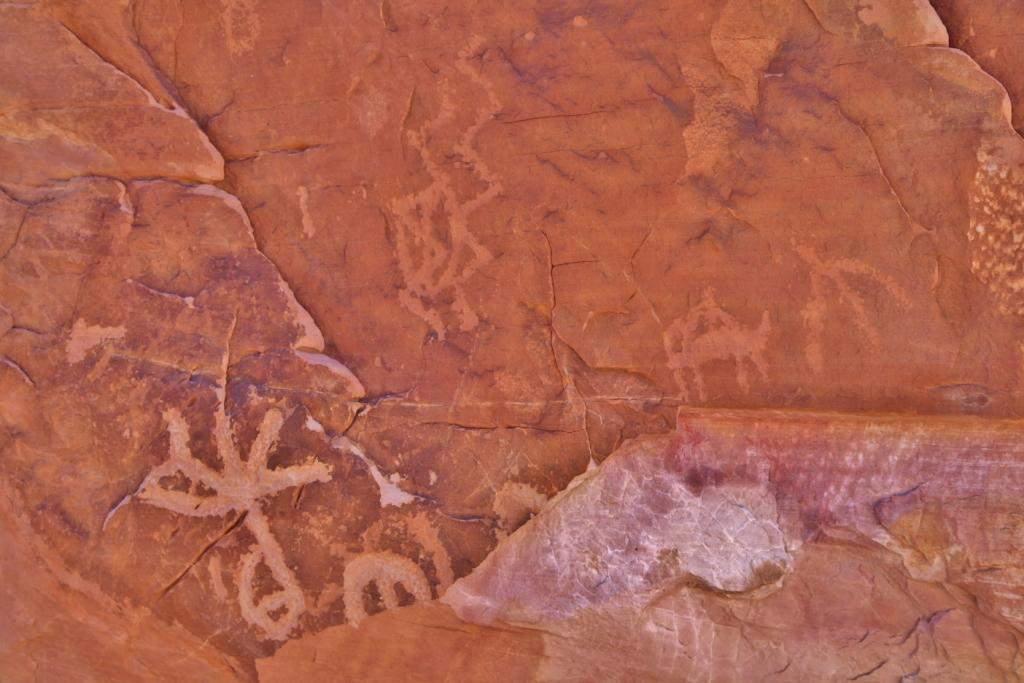
9 After coming up Sand Wash Road, our first petroglyph stop was the 21 Sheep (or Goats) panel

10 Bands of Archaic hunter-gatherers lived here, followed by the Virgin Branch of the Kayenta Anasazi. When the Anasazi left sometime around 1000 CE the Patayan and southern Paiute made Gold Butte their home. This is one of the longest petroglyphs panels around. There are two rows of glyphs, with the upper row being at least feet long. The upper row contains twenty-one zoomorphs (goats or big horn sheep) in a single line. Below and to the left of this depiction, there are two more sections containing some abstract glyphs, as well as another dozen zoomorphs. This entire panel seems to contain only one glyph that may be representative of a human figure. Though there were many Indian tribes who used this area as a migration corridor, the petroglyphs are probably Virgin River Anasazi (Ancestral Puebloan). It has been estimated that some of these glyphs are more than 500 years old.

11 LaVan Martineau, an orphan caucasian who was adopted by the Paiutes, extensively studied rock art and believes that the bighorn does not always necessarily stand for the actual animal, but rather represents travel and direction; that how the horns are "written" has specific meaning. Looking at these depictions you can see many different variations. Some "goats" are level, some tilted uphill others downhill. Some horns are arches, others right angles. Some feet are fluid and limber others like sticks and still others split in two at the hooves. Some are clearly traveling alongside a pecked line or "trail" and a couple are going the opposite direction. Some horns are longer over the back and others short. Some animals are full and others are stick-like figures.

12 Rock art is abstract, and made by prehistoric hunter-gatherers some 1200 years ago. The images are symbolic, and even though archaeologists can t interpret most of them, they still had meaning for the migratory people who once lived here. The images may have functioned as territorial markers, as ways of telling stories and documenting events such as the Falling Man that we visited after this 21 Sheep Panel. Once this area was covered with archeological features such as agave roasting pits and a prehistoric campsites although now only the petroglyph s remain.

13 Mike Hess, a bit of a mountain goat himself, looks for a "different angle" to view the surroundings.

14 A picturesque arch in the 21 Sheep Panel area
 in the")
15 Below is a concrete dam constructed by the Civilian Conservation Corps (CCC's) in the 1930's

16 The dam, built of concrete with an earthen front berm has collected a considerable amount of sediment over the decades

17 Lunch at the Falling Man petroglyph site. The Jeepers enjoyed some mid-60's temperatures, light breeze and great company.

18 Scenery around the Falling Man petroglyph site

19

20

21

22 Following is a series of petroglyph photos in the Falling Man area

23
24

25 An early pioneer left his mark. Fortunately, the area is relatively free of vandalism despite its easy accessibility

26 Weathering clearly demonstrates the time span between early and later pecking. This is evident on most of the panels throughout the southwest where bands of people moved through over time. People obviously spent considerable time here despite, at least in present day, no water close by.

27

28

29

30 A panel often called the "Newspaper" Panel

31 This panel was created on a surface that seemed somewhat foreign to the area

32

33

34


35

36

37

38 Sometimes it is hard to distinguish modern pecking from original rock art

39 Viewing the Falling Man petroglyph. What the glyph represents is not definitively known.

40

41

42

43 Exploring the area

44 Balance Rock

45

46

47

48 Mike Hess framed by a window

49 Karen Bishop through a window

50 Lining up to make their way through the "keyhole" window

51 A view looking west through the keyhole

52 Notice the small sheep panel to the right of the keyhole

53 One characteristic that was almost universal as everyone made their way through the keyhole was a big smile. People were overheard to remark that they wouldn't have thought that they could traverse these rocks, but they said they were having a ball!

54

55

56

57

58

59

60

61 The "Rabbit Ears" petroglyphs

62 To learn more about rock art you may visit this interesting site: So concluded another great day on the trail! Submitted by Bud Sanders
Chapter 6. Field Trip to Sandia Mountains.
 University of New Mexico Biology 310L Principles of Ecology Lab Manual Page -40 Chapter 6. Field Trip to Sandia Mountains. Outline of activities: 1. Travel to Sandia Mountains 2. Collect forest community
St. George Jeepers Trail Report
 St. George Jeepers Trail Report Snow Run, Diamond Valley to Baker Reservoir to Pine Valley, Tuesday, February 02, 2016 Sometimes a person wonders how a day could be any more sparkling than this day. It
St. George Jeepers Trail Report Moapa to Valley of Fire State Park to Overton, Nevada-March 14, 2017
 St. George Jeepers Trail Report Moapa to Valley of Fire State Park to Overton, Nevada-March 14, 2017 Nine Jeeps met at the Mesquite, Nevada, Chevron on this crystal clear, pleasant morning. We traveled
Module 10: Resources and Virginia Geology Topic 4 Content: Virginia Geology Notes
 Virginia is composed of a very diverse landscape that extends from the beaches and barrier islands all of the way to the highly elevated Appalachian Plateau. Geologists have discovered ancient shallow
Upper Owyhee Watershed Assessment
 * Owyhee Watershed Council and Scientific Ecological Services The upper Owyhee subbasin is located in parts of three states: the southeastern corner of Oregon, the southwestern corner of Idaho, and north
Colorado Prehistory: A Context For The Southern Colorado River Basin READ ONLINE
 Colorado Prehistory: A Context For The Southern Colorado River Basin READ ONLINE If you are searched for the ebook Colorado Prehistory: A Context for the Southern Colorado River Basin in pdf format, then
Earth History: Record in the Rocks
 Earth History: Record in the Rocks The geologic history of Earth can be read from rocks if you know what to look for. In this presentation, you will see examples of many types of clues, stored in rocks.
High Impact Forces of Nature Hazards in and Around Rocky Mountain National Park
 Stop 1 High Impact Forces of Nature Hazards in and Around Rocky Mountain National Park Trip Leader Vince Matthews, Colorado Geological Survey RMAG on the Rocks July 28, 2007 Welcome to the July RMAG on
!! The Rio Grande River starts at the Rocky Mountains in Colorado. This River is 1,885 miles long!
 The Southwest Region By Taylor Noble and Kaiya Leismer Land and water The southwest region covers a lot of land but the Southwest region has lowest amount of states in any other region. In the Southwest
Today s Airtime: 4.6 Total PIC Time: Total Logged Time:
 Saturday, April 28, 2012 410th Cobra flight, 422nd PIC, 4 landings Flight to Grants with Jayne, Flight over Malpais with Larry, Return flight to Belen At my Over New Mexico lecture last summer, I offered
CANYON THE. The Grand Canyon A Reading A Z Level K Leveled Book Word Count: 394 H K N. LEVELED BOOK K Grand
 The Grand Canyon A Reading A Z Level K Leveled Book Word Count: 394 Connections Writing and Art What would you like to do at the Grand Canyon? Why? Draw a picture and write five or more sentences about
Natural Texas. Regions and Climates
 Natural Texas Regions and Climates Two Kinds: Physical geography Climate, vegetation, rivers, lakes, oceans, plateaus, plains, and mountain ranges Human geography Economic activities How we earn a living
CANYON THE. The Grand Canyon A Reading A Z Level N Leveled Book Word Count: 563 H K N. LEVELED BOOK N Grand
 The Grand Canyon A Reading A Z Level N Leveled Book Word Count: 563 Connections Writing and Art What would you like to do at the Grand Canyon? Why? Draw a picture and write five or more sentences about
Changes to Land 5.7B. landforms: features on the surface of Earth such as mountains, hills, dunes, oceans and rivers
 All the landforms on Earth have changed over time and continue to change. Many of the changes were caused by wind, moving water, and moving ice. Mountains have grown and shrunk. Rivers have cut away land
By Karen Phillips. 12/06
 By Karen Phillips. 12/06 Questions The First Americans: Who, What, When, Where, How, Why? Who were the first Americans? When did the first Americans start arriving? Where did they come from? Where did
Changes in Texas Ecoregions
 Comment On Lesson Changes in Texas Ecoregions The state of Texas can be divided into 10 distinct areas based on unique combinations of vegetation, topography, landforms, wildlife, soil, rock, climate,
Think about the landforms where you live. How do you think they have changed over time? How do you think they will change in the future?
 reflect All the landforms on Earth have changed over time and continue to change. Many of the changes were caused by wind, moving water, and moving ice. Mountains have grown and shrunk. Rivers have cut
EXPLORER S GUIDE FOR A SELF-GUIDED VISIT. Welcome to the Arizona-Sonora Desert Museum!
 EXPLORER S GUIDE FOR A SELF-GUIDED VISIT Welcome to the Arizona-Sonora Desert Museum! Instructions: Review the questions in this guide before you visit the Desert Museum. You should be able to find all
Desert INTRODUCTION. Very few of the world's deserts are barren, windswept sand dunes. Only 30% of the Sahara is sand dunes like the ones shown here.
 Desert INTRODUCTION Scientists define a desert as a region that receives less than 25 centimeters (10 inches) of rain per year. About onethird of Earth s land surface is desert. Deserts may be hot or cold,
California Parks (C18A-2)
") California Parks (C18A-2) After I left Los Angeles I headed north with plans to visit some California parks, including Carrizo Plain National Monument, Sequoia and Kings Canyon National Parks (technically
California Parks (C18A-2) After I left Los Angeles I headed north with plans to visit some California parks, including Carrizo Plain National Monument, Sequoia and Kings Canyon National Parks (technically
How does erosion happen?
 How does erosion happen? By National Geographic, adapted by Newsela staff on 10.03.17 Word Count 682 Level 830L These rock formations, in Bryce Canyon National Park, Utah, are called hoodoos. Although
EROSIONAL FEATURES. reflect
 reflect Have you ever looked at the land around you and wondered what processes shaped what you see? Perhaps you see mountains, valleys, rivers, or canyons. Do you know how long these geologic features
Erosional Features. What processes shaped this landscape?
 Have you ever looked at the land around you and wondered what processes shaped what you see? Perhaps you see mountains, valleys, rivers, or canyons. Do you know how long these geologic features have been
Putative Canada Lynx (Lynx canadensis) Movements across I-70 in Colorado
 Movements across I-70 in Colorado") Putative Canada Lynx (Lynx canadensis) Movements across I-70 in Colorado INTRODUCTION March 8, 2012 Jake Ivan, Mammals Researcher Colorado Parks and Wildlife 317 W. Prospect Fort Collins, CO 80526 970-472-4310
Putative Canada Lynx (Lynx canadensis) Movements across I-70 in Colorado INTRODUCTION March 8, 2012 Jake Ivan, Mammals Researcher Colorado Parks and Wildlife 317 W. Prospect Fort Collins, CO 80526 970-472-4310
S E M I N O E S T A T E P A R K ACTIVITY BOOK. Wyoming State Parks, Historic Sites & Trails. Sponsored by
 S E M I N O E S T A T E P A R K ACTIVITY BOOK Wyoming State Parks, Historic Sites & Trails Sponsored by What can you find at Seminoe State Park? The words go forward and down. G I E Q Z Z U V X C R C T
Draft exercise for share fair at Bozeman workshop only. This exercise is not ready for distribution. Please send helpful suggestions to
 Draft exercise for share fair at Bozeman workshop only. This exercise is not ready for distribution. Please send helpful suggestions to foleyd@plu.edu Figure list 1. Trailer photograph 2. Location map
Grade Five Social Studies Assessment Regions/Native Americans
 Name Grade Five Social Studies Assessment Regions/Native Americans Use the map below to answer questions 1 and 2 1. (Geo 1) For this location give the name of the city found there. 38 N, 100 W a. Scottsbluff
Session 6: Locating the Eastern Woodlands, Plains, and Southwest Regions on a United States Map
 Session 6: Locating the Eastern Woodlands, Plains, and Southwest Regions on a United States Map Prerequisite Understanding/Knowledge/Skills Students are expected to be able to use a U.S. map to locate
Chapter 3 Erosion in the Las Vegas Wash
 Chapter 3 Erosion in the Las Vegas Wash Introduction As described in Chapter 1, the Las Vegas Wash (Wash) has experienced considerable change as a result of development of the Las Vegas Valley (Valley).
The Little Colorado River
 The Little Colorado River The Little Colorado River Junction of the Little Colorado River and the Colorado Grand Falls of the Little Colorado River The relief/topo map at the right shows the junction of
A River Runs Through It
 A River Runs Through It Once you find the geocache, click "Found It" on the Geocaching.com app and then read and answer the questions below. Make sure to return the cache to exactly the same place you
Parts of a Map. Map Skills. The Title. There are 4 main parts of a map: The Title The Compass Rose The Map Key The Scale
 Map Skills Parts of a Map There are 4 main parts of a map: The Title The Compass Rose The Map Key The Scale The Title The title of the map is usually at the top and describes the topic of the map Example:
Extreme Weather. Extreme weather has always been a part of Utah
 Climate Notes Extreme Weather Extreme weather has always been a part of Utah Floods Severe storms Wind 1920 Lehi hail storm killed birds and chickens 1971 Farmington wind storm Climate vs. Weather Climate:
SCI-5 KES 5.7 Geology Post-test Exam not valid for Paper Pencil Test Sessions
 SCI-5 KES 5.7 Geology Post-test Exam not valid for Paper Pencil Test Sessions [Exam ID:1D5NLH 1 Earth's crust is made of plates that move slowly. This movement changes the appearance of the Earth's crust
Early College High School PreAP World Geography Summer Reading Assignment
 Early College High School PreAP World Geography Summer Reading Assignment In preparation for your studies in World Geography you will be familiarizing yourself with the 5 Themes of Geography. This assignment
US82 ROCKFALL MITIGATION PROJECT May, BY Mohammed Ghweir Engineering Geologist Geotechnical Design Section New Mexico DOT
 US82 ROCKFALL MITIGATION PROJECT May, 2009 BY Mohammed Ghweir Engineering Geologist Geotechnical Design Section New Mexico DOT SACRAMENTO MTS Rock Fall Signs Back Ground US82 Connects the Town of Alamogordo,
BISTI / DE-NA-ZIN WILDERNESS
 BISTI / DE-NA-ZIN WILDERNESS Activities: Facilities: Season / Hours: Description: Hiking and photography. No electrical hookups, water, or restrooms are available. Open year-round. The Bisti/De-Na-Zin
[LLAZC X.L EA0000; AZ SRP ] Notice of Temporary Closures: Selected Public Lands in La Paz County, AZ
![[LLAZC X.L EA0000; AZ SRP ] Notice of Temporary Closures: Selected Public Lands in La Paz County, AZ](/thumbs/89/100188672.jpg "[LLAZC X.L EA0000; AZ SRP ] Notice of Temporary Closures: Selected Public Lands in La Paz County, AZ") This document is scheduled to be published in the Federal Register on 12/29/2017 and available online at https://federalregister.gov/d/2017-28217, and on FDsys.gov 4310-32 DEPARTMENT OF THE INTERIOR Bureau
This document is scheduled to be published in the Federal Register on 12/29/2017 and available online at https://federalregister.gov/d/2017-28217, and on FDsys.gov 4310-32 DEPARTMENT OF THE INTERIOR Bureau
Chapter 2 Planet Earth
 Chapter 2 Planet Earth Section Notes Earth and the Sun s Energy Water on Earth The Land Close-up The Water Cycle World Almanac Major Eruptions in the Ring of Fire Quick Facts Chapter 2 Visual Summary Video
Maine Geologic Facts and Localities October, Lobster Lake, Maine. Text by Robert G. Marvinney. Maine Geological Survey
 Maine Geologic Facts and Localities October, 1998 Lobster Lake, Maine 45 o 51 7.91 N, 69 o 30 53.88 W Text by Robert G. Marvinney, Department of Agriculture, Conservation & Forestry 1 Map by Introduction
Southwest Indians NEW YORK TORONTO LONDON AUCKLAND SYDNEY MEXICO CITY NEW DELHI HONG KONG BUENOS AIRES B Y D O N A L D M.
 Easy Make & Learn Projects Southwest Indians B Y D O N A L D M. S I L V E R A N D P A T R I C I A J. W Y N N E NEW YORK TORONTO LONDON AUCKLAND SYDNEY MEXICO CITY NEW DELHI HONG KONG BUENOS AIRES F or
The United States & Canada. A Regional Study of Anglo America
 A Regional Study of Anglo America Landform Regions of the United States & Canada world leaders in agricultural and industrial production because of... VAST LANDS stretch from the Atlantic Ocean on the
A GEOLOGIC TRIP to the SAN ANDREAS FAULT
 A GEOLOGIC TRIP to the SAN ANDREAS FAULT San Andreas Hot Spot Loop Road Hot Spot P Parking San Andreas Fault Interpretive Trail Fault Zone Map: San Andreas Fault Zone During the 25 million years that the
[LLAZC03000.L EA0000 LVRCA13SA A, AZ SRP Notice of Temporary Closures of Public Lands in La Paz County, AZ
 This document is scheduled to be published in the Federal Register on 01/15/2013 and available online at http://federalregister.gov/a/2013-00542, and on FDsys.gov 4310-32-P DEPARTMENT OF THE INTERIOR Bureau
Weather History on the Bishop Paiute Reservation
 Weather History on the Bishop Paiute Reservation -211 For additional information contact Toni Richards, Air Quality Specialist 76 873 784 toni.richards@bishoppaiute.org Updated 2//214 3:14 PM Weather History
North America ATLANTIC OCEAN PACIFIC OCEAN. The First Americans. Labrador Sea. Caribbean Sea. USI_ISN_U01_01.eps. Second Proof TCI19 65.
 G e o g r a p h y C h a l l e n g e North America 70 N 180 N 60 170 W 30 W 160 W 40 W Labrador Sea 150 W 50 N 50 W Hud s on B ay 140 W 40 N 60 W ATLANTIC OCEAN 30 N PACIFIC OCEAN Gulf of Mexico 20 N 130
1.8 Ga metamorphic rocks of Mingus Mountain. (Note: All digital images by Prof. C. Merguerian.)
") Geology 143A: Field Course to Northern Arizona Led By: Dr. Charles Merguerian, Chairman, Geology Department Spring 2010 Spring Break (March 27-Apr 3, 2010) Through an integrated lecture and field course,
Geology 143A: Field Course to Northern Arizona Led By: Dr. Charles Merguerian, Chairman, Geology Department Spring 2010 Spring Break (March 27-Apr 3, 2010) Through an integrated lecture and field course,
Activity 3.2: Effigy Mounds
 3 Wisconsin s First People : Effigy Mounds Teacher Materials Background Information to Share Most effigy mound sites are found in Wisconsin, and most are within the southern half of the state. A few sites
Observing Subtleties: Traditional Knowledge and Optimal Water Management of Lake St. Martin
 Observing Subtleties: Traditional Knowledge and Optimal Water Management of Lake St. Martin Myrle Traverse and Richard Baydack Abstract Lake St. Martin First Nation is an Anishinaabe community situated
Structural Geology Lab. The Objectives are to gain experience
 Geology 2 Structural Geology Lab The Objectives are to gain experience 1. Drawing cross sections from information given on geologic maps. 2. Recognizing folds and naming their parts on stereoscopic air
Geology 109L Lab 3: Modern Sedimentary Environments --Field Trip to Bodega Bay--
 Geology 109L Lab 3: Modern Sedimentary Environments --Field Trip to Bodega Bay-- Goal: The purpose of this lab is to recognize characteristics of modern sedimentary environments, which will aid you in
EQ: Discuss main geographic landforms of the U.S. & Canada and examine varied landforms in relation to their lifestyles.
 EQ: Discuss main geographic landforms of the U.S. & Canada and examine varied landforms in relation to their lifestyles. Places & Terms for Discussion Appalachian Mountains Great Plains Canadian Shield
That gives shades all day for you and me.
 The Jungles My own little jungles I know so well Beside the old road with a story to tell; For in its borders are so many things That remind me of my travels and flings. All built with trellis painted
Chapter 6 Mapping and Online Tools
 Chapter 6 Mapping and Online Tools The stream site you monitor is just part of a much larger system. When analyzing stream health, it is important to take a holistic view by considering the entire watershed.
LANDSCAPE CHANGE IN THE SOUTHWEST: Historical changes in selected ecosystems of the southwestern United States
 LANDSCAPE CHANGE IN THE SOUTHWEST: Historical changes in selected ecosystems of the southwestern United States Robert H. Webb U.S. Geological Survey 520 N. Park Avenue Tucson, AZ 85719 rhwebb@usgs.gov
MONITORING THE EFFECTS OF CLIMATE CHANGE ON SPRINGS, SEEPS AND OTHER WATER NATIONAL PRESERVE
 MONITORING THE EFFECTS OF CLIMATE CHANGE ON SPRINGS, SEEPS AND OTHER WATER RESOURCES IN THE MOJAVE NATIONAL PRESERVE Boris Poff and Debra Hughson Mojave National Preserve, California CLIMATE CHANGE Predictions
Arizona Recreation Map By Benchmark Maps READ ONLINE
 Arizona Recreation Map By Benchmark Maps READ ONLINE Families can come and see what the Sierra Montana Recreation Center has to offer. The center has a game room with Xbox 360s on high definition TV's,
Objectives. Understand the different physical & human characteristics of each region
 TEXAS REGIONS Objectives Know the 4 regions of Texas Understand the different physical & human characteristics of each region Understand how physical differences affect human characteristics (way of life)
Photographing the Border: The Landscape Behind the Politics
 Photographing the Border: The Landscape Behind the Politics By JOHN GUIDA JANUARY 27, 2015 Faint trail, Granitic Mountains near Raven Butte. Credit Photographs by Mark Klett For some, the border between
Science EOG Review: Landforms
 Mathematician Science EOG Review: Landforms Vocabulary Definition Term canyon deep, large, V- shaped valley formed by a river over millions of years of erosion; sometimes called gorges (example: Linville
MOR TIME TEACHERS. ONCE UPON A TIME Activity Overview BIG IDEA
 MOR TIME 04 Activity Overview BIG IDEA OBJECTIVE BACKGROUND The geologic time scale can be challenging for students to understand. This activity explores how scientists divide the Earth s long history
Our Environment Class 7 Questions on Give Reasons for quick revision for Competitive Exams
 Questions on Give reasons at the end of each Chapter Chapter 1 1. Man modifies his environment Man has tried to make life more comfortable for his own species on a continuous basis. For this he has learnt
Utah Core Standards Science Grade: 4 - Adopted: 2002
 Main Criteria: Utah Core Standards Secondary Criteria: Subjects: Science, Social Studies Grade: 4 Correlation Options: Show Correlated UT.1. Utah Core Standards Science Grade: 4 - Adopted: 2002 Intended
Florida s Changing Shape
 Florida s Changing Shape Background: For much of its history, Florida was underwater. At first, Florida consisted solely of the Florida Platform, a limestone base formed from the calcium carbonate remains
NOTES 1. Fossils. The BIG Idea Rocks, fossils, and other types of natural evidence tell Earth s story.
 Name Period Date UNIT 6 NOTES 1 Fossils Objectives Identify and describe the types of fossils. Define fossils Explain fossil formation Explain how different kinds of fossils show traces of life from Earth
RASI Survey of Sites in Petrified Forest National Park 2010
 RASI Survey of Sites in Petrified Forest National Park 2010 Kaelin Groom and Rachel Poole Abstract Many panels of rock art in the Petrified Forest National Park have fallen victim to extreme weathering
The Aztec Sunstone Calendar Tonal Machiotl means the footprints of the history of the world. Translated, Tonal is Sun energy, and Machiotl is
 The Aztec Sunstone Calendar Tonal Machiotl means the footprints of the history of the world. Translated, Tonal is Sun energy, and Machiotl is impression/print. This monolith relic is at the INAH museum
Topographic Recreational Map Of New Mexico: Detailed Travel Map By GTR Mapping
 Topographic Recreational Map Of New Mexico: Detailed Travel Map By GTR Mapping Biological Assessment for Proposed Reconstruction of New Mexico Forest Highway 12. Cuba and Jemez Recreation Opportunity Spectrum
Rocky Mountain Field Institute 2015 Annual Report Waldo Canyon Fire Restoration December 17, 2015
 December 17, 2015 815 South 25 th St, Suite 101 Colorado Springs, CO 80904 www.rmfi.org Dedicated to the conservation and stewardship of public lands in the Pikes Peak Region 2 Background In the summer
THE TWO MOST SIGNIFICANT ARCHEOLOGICAL SITES IN KERR COUNTY, TEXAS ARE THE GATLIN SITE AND THE BEARING SINK HOLE SITE.
 WHAT ARE THE MOST IMPORTANT ARCHEOLOGY SITES IN KERR COUNTY? By Steve Stoutamire THE TWO MOST SIGNIFICANT ARCHEOLOGICAL SITES IN KERR COUNTY, TEXAS ARE THE GATLIN SITE AND THE BEARING SINK HOLE SITE. Map
Sherman Falls -Virtual Field Trip-
 Sherman Falls -Virtual Field Trip- School of GEOGRAPHY & GEOLOGY Carolyn Eyles & Susan Vajoczki Prepared by Zachary Windus and Liz Kenny Directions: McMaster University to Sherman Falls From McMaster University
HISTORY & GEOGRAPHY 702 (NEW EDITION)
") Geography CONTENTS Introduction.......................................................... 2 Curriculum Outline.................................................... 3 HISTORY & GEOGRAPHY 702 (NEW EDITION)
Geography CONTENTS Introduction.......................................................... 2 Curriculum Outline.................................................... 3 HISTORY & GEOGRAPHY 702 (NEW EDITION)
Field Notes for the Mauna Loa North Slope Field Trip
 Field Notes for the Mauna Loa North Slope Field Trip 22 August, 2012 (Leaders: Darcy Bevens and Jack Lockwood) Checklist of suggested items you should bring: Sun screen Warm clothes (it can be very cold
Weathering and Soil Formation. Chapter 10
 Weathering and Soil Formation Chapter 10 Old and New Mountains The Appalachian Mountains appear very different from the Sierra Mountains. The Appalachians are smaller, rounded, gently sloping, and covered
David Gold Hiking Tours
 David Gold Hiking Tours Join us for a West Texas Active Adventure Tour February 14 21, 2017 Led by David Gold and Ulrike Porat The Big Bend area of West Texas is one of the most remote, and least visited
The Geology of Sebago Lake State Park
 Maine Geologic Facts and Localities September, 2002 43 55 17.46 N, 70 34 13.07 W Text by Robert Johnston, Department of Agriculture, Conservation & Forestry 1 Map by Robert Johnston Introduction Sebago
1. What is the definition of uniformitarianism? 2. What is the definition of organic? 4. What is the definition of inorganic?
 Earth Science Unit 3- History of the Earth Knowledge Packet Learning Target 3B: Have you ever thought about the history of the Earth? No, well you should have because it s pretty cool. Things like mountain
Pastoralists and GIS: Predictive Modeling and Campsite Location in Beidha, Southern Jordan
 Pastoralists and GIS: Predictive Modeling and Campsite Location in Beidha, Southern Jordan Outline Predictive Modeling: Why? Why Beidha? Modeling Parameters: What works, What Doesn't. The Model. The Next
Name a sedimentary rock and explain how was it formed. Y11 Changing landscapes of the UK
 Name a sedimentary rock and explain how was it formed Small particles that have been transported and deposited in layers, such as sandstone; or from the remains of plants and animals e.g. chalk. Pressure
Changes in Texas Ecoregions Copy the questions and answers
 Changes in Texas Ecoregions Copy the questions and answers 1. What are some kinds of damage that hurricanes cause? Roads and bridges might be washed away. Trees and power lines can be knocked down. Area
Geology, People, Environment and Sustainable Resources Development of Ladakh
 Field Excursions: Geology, People, Environment and Sustainable Resources Development of Ladakh Friday 27 th to Monday 30 th June/ Tuesday 1 st July to Friday 4 th July 2014 Leh and the Ladakh Batholith
Essential Questions. What is erosion? What is mass wasting?
 Erosion Essential Questions What is erosion? What is mass wasting? What is Erosion? Erosion The transportation of sediment from one area to another Caused mainly by running water but also caused by glaciers,
Laboratory Exercise #4 Geologic Surface Processes in Dry Lands
 Page - 1 Laboratory Exercise #4 Geologic Surface Processes in Dry Lands Section A Overview of Lands with Dry Climates The definition of a dry climate is tied to an understanding of the hydrologic cycle
Alamito Waters Ranch 80 acres, Presidio County, Texas James King, Agent Office Cell
 Alamito Waters Ranch 80 acres, Presidio County, Texas James King, Agent Office 432-426-2024 Cell 432-386-2821 James@KingLandWater.com King Land & Water LLC P.O. Box 109, 600 State Street, Fort Davis, TX
Landform Regions of Canada
 Landform Regions of Canada The movement of the earth s plates, and the resulting folding, faulting, and volcanic activity, have combined with the forces of erosion and weathering to create a variety of
Waterbury Dam Disturbance Mike Fitzgerald Devin Rowland
 Waterbury Dam Disturbance Mike Fitzgerald Devin Rowland Abstract The Waterbury Dam was completed in October 1938 as a method of flood control in the Winooski Valley. The construction began in April1935
Five Themes of Geography. By PresenterMed
 Five Themes of Geography By PresenterMed Geography Geography: the study of the Earth Where are things located? Why are they there? Location Location: where a place is Cardinal Directions: North, South,
SUMMARY. ) t, UNIT. Constant velocity represents uniform motion. Acceleration causes a change in velocity.
 t, UNIT. Constant velocity represents uniform motion. Acceleration causes a change in velocity.") UNIT A SUMMARY KEY CONCEPTS CHAPTER SUMMARY 1 Constant velocity represents uniform motion. Distance and Displacement Position-time graphs Average speed and average velocity Positive, negative, and zero
UNIT A SUMMARY KEY CONCEPTS CHAPTER SUMMARY 1 Constant velocity represents uniform motion. Distance and Displacement Position-time graphs Average speed and average velocity Positive, negative, and zero
Fickeisen Plains Cactus (Pediocactus peeblesianus ssp. fickeiseniae)
") Fickeisen Plains Cactus (Pediocactus peeblesianus ssp. fickeiseniae) Monitoring Report Salt Trail Canyon Monitoring Site 2006-2008 Daniela Roth Navajo Natural Heritage Program Department of Fish & Wildlife
Fickeisen Plains Cactus (Pediocactus peeblesianus ssp. fickeiseniae) Monitoring Report Salt Trail Canyon Monitoring Site 2006-2008 Daniela Roth Navajo Natural Heritage Program Department of Fish & Wildlife
Ebook Code: REAU1124. Developing English Skills Through Themes
 Ebook Code: REAU1124 Developing English Skills Through Themes Contents Teachers Notes 4 Curriculum Links 5 Antarctica 6 Activity Sheets 7-11 Dinosaurs 12 Activity Sheets 13-17 Natural Disasters 18 Activity
Travelers usually left in May and hoped to reach Oregon by October. It took them 6 months to make the 2200-mile journey. Each wagon train headed west
 Oregon or Bust The Oregon Trail The Oregon Trail opened in 1841 with 35 men, 5 women, and 10 children using it to make the trek from Independence, Missouri, to Oregon City, Oregon. In 1842, 100 emigrants
GLY 155 Introduction to Physical Geology, W. Altermann. Press & Siever, compressive forces. Compressive forces cause folding and faulting.
 Press & Siever, 1995 compressive forces Compressive forces cause folding and faulting. faults 1 Uplift is followed by erosion, which creates new horizontal surface. lava flows Volcanic eruptions cover
World Geography Chapter 3
 World Geography Chapter 3 Section 1 A. Introduction a. Weather b. Climate c. Both weather and climate are influenced by i. direct sunlight. ii. iii. iv. the features of the earth s surface. B. The Greenhouse
Vancouver Island and Coast
 Places in B.C. This handout package provides students with a brief overview of one of seven regions in B.C. These descriptions will help students audit the different types of energy (see the Energy Primers)
Alamito Creek Preserve Ranches for Sale Marfa, Presidio County, Texas
 Alamito Creek Preserve Ranches for Sale Marfa, Presidio County, Texas James King, Agent Office 432 426.2024 Cell 432 386.2821 James@KingLandWater.com Alamito Creek Preserve Various size Ranch Properties,
Beyond the Book. FOCUS Book
 FOCUS Book Suppose your city wants to build a new housing development on a steep slope outside town. Design a model to test whether the land is safe from the types of landslides you read about in this
Your web browser (Safari 7) is out of date. For more security, comfort and the best experience on this site: Update your browser Ignore
 is out of date. For more security, comfort and the best experience on this site: Update your browser Ignore") Your web browser (Safari 7) is out of date. For more security, comfort and the best experience on this site: Update your browser Ignore ALLU VIAL FAN colluvial fan, debris cone For the complete encyclopedic
Your web browser (Safari 7) is out of date. For more security, comfort and the best experience on this site: Update your browser Ignore ALLU VIAL FAN colluvial fan, debris cone For the complete encyclopedic
Ceramic compositional analysis projects Funded by the Begole Archaeological Research Grant Program
 Ceramic compositional analysis projects Funded by the Begole Archaeological Research Grant Program 2006 Compositional analysis of prehistoric ceramics from the Anza-Borrego desert: Seeking provenience
THE MAMMOTH "EARTHQUAKE FAULT" AND RELATED FEATURES IN MON0 COUNTY, CALIFORNIA* By H. BENIOFF and B. GUTENBERG
 THE MAMMOTH "EARTHQUAKE FAULT" AND RELATED FEATURES IN MON0 COUNTY, CALIFORNIA* By H. BENIOFF and B. GUTENBERG IN UNDERTAKING this work it was our intention to investigate the well-known "Earthquake Fault"
Kunjamma Father s younger brother s wife in Malayalam. For the teacher: Chittappan Father s younger brother in Malayalam.
 Today, there was a lot of activity at Maalu s house. Chittappan and his family were coming home after five years. Chittappan had got a job in a country called Abu Dhabi five years ago. Since then he had