Galilee Basin. Galilee Basin Hydrogeological Investigations. Briefing to RAPAD Longreach, 16 May rpsgroup.com.au
|
|
|
- Francine Simon
- 5 years ago
- Views:
Transcription


1 Galilee Basin Galilee Basin Hydrogeological Investigations Briefing to RAPAD Longreach, 16 May
2 The Galilee Basin Geologically & hydrogeological diverse sedimentary Covers 247,000 km 2 The Galilee Basin extends:» 700 km from Charleville in the South to near Charter Towers in the north; and» 550 km east to west from east of Emerald in the east to Julia Creek in the northwest. Petroleum exploration leases cover nearly the entire basin, but most active exploration is occurring in the northern region Significant coal development underway in eastern area north of Alpha


3 Galilee Basin study area Julia Creek Richmond Hughenden Charters Towers Winton Longreach Aramac Barcaldine Alpha Blackall Quilpie Charleville


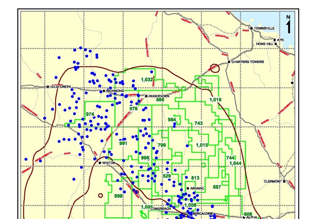
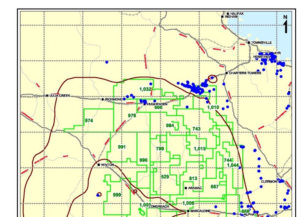
4 Galilee tenements of interest

5 Galilee Basin surface geology
6 Stratigraphic Relationships & Groundwater Major alluvium / bed sands of inland rivers Rolling Downs Group (e.g. Winton Fm & Wallumbilla Fm) Eromanga Basin Cadna-Owie Fm Hooray Sst Adori Sst Galilee Basin - Triassic Hutton Sst Major Unconformity Clematis Group / Warang Sst Galilee Basin - Permian Major Unconformity Betts Ck Beds, Aramac Coal Measures etc.
7 Significance of the major unconformities The unconformities:» Mark the stratigraphic boundaries for the: Basement rock; Galilee Basin sediments; and Eromanga Basin sediments.» Mark major changes in erosional and depositional environments.» Influence the connections between aquifers. For example, the Moolayember Formation, a regional confining layer, underlies the basal Jurassic unconformity.» Define the Permian age sediment outcrop areas, which correspond to the GAB intake beds.
8 Generalised section A A

9 Section A Eromanga Basin Great Artesian Basin Galilee Basin Joe Joe Gp


10 Generalised section B B

11 Section B Eromanga Basin Great Artesian Basin Galilee Basin Hooray Sst Colinlea Sst Betts Ck Beds Joe Joe Group


12 Basal Jurassic unconformity structure contours

13 Mid-Permian unconformity structure contour
14 The challenge Develop a baseline understanding of groundwater resources within the Eromanga and Galilee Basin strata:» Identify the major aquifers; &» Identify the major confining units Develop an understanding of the groundwater flow regime:» Identify the barriers and linkages between the groundwater systems and the CSG production horizons. Develop a baseline groundwater quality data set
15 DERM Groundwater Database Search Statistic Value Units Number of bores with any DERM records 10,442 (bores) Number of bores on GBOF tenements 3,247 (bores) Number of bores with aquifer unit identified 6,828 (bores) Number of bores with aquifer unit identified on GBOF tenements 1,011 (bores) Number of bores with DERM yield records 2,090 (bores) Number of bores with depth DERM records 2,660 (bores) Number of standing groundwater level measurements 41,579 (number) Number of standing groundwater level measurements on GBOF tenements 2,428 (number) Number of bores with DERM standing groundwater level data 4,405 (bores)

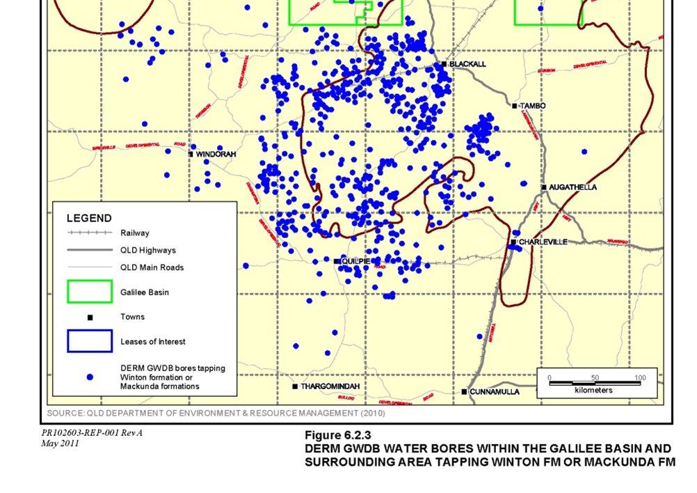
16 DERM registered bores
17 QPED Exploration Wells Statistic Value Units Number of wells with any QPED records 370 (wells) Number of wells on GBOF tenements (1) 147 (wells) Number of wells with stratigraphic units recorded 258 (wells) Number of wells with QPED DST records 116 (wells) Earliest recorded drill date 1922 (year) Earliest recorded drill date on a GBOF tenement 1927 (year) Number of wells with reported DST water quality 29 (wells) (1) Value does not include recent CSG well.


18 QPED exploration wells


19 Intake bed springs The GAB recharge springs in the Galilee basin occur in association with the intake bed out crops and sub-crop areas.

20 General groundwater use The major unconformities can be used as a guide to where water bores will be tapping Permian age sediments vs. where water bores will tap Triassic age and younger sediments Permian age aquifers are tapped in the east Jurassic & younger age aquifers are tapped in the west.


21 Groundwater use Drummond Basin


22 Groundwater use Betts Ck Beds / Colinlea Sst
23 Groundwater use Rewan Fm / Dunda Beds

24 Groundwater use Clematis Sst / Moolaymember Fm / Warang Sst
25 Groundwater use Precipice Sst

26 Groundwater use Boxvale Sandstone

27 Groundwater use Hutton Sst
28 Groundwater use Injune Creek Group / Westbourne Fm / Adori Sst / Birkhead Fm


29 Groundwater use Hooray Sst / Gilbert River Sst / Mooga Sst
30 Groundwater use Wyandra Sst / Cadna-Owie Fm / Bungil Fm


31 Groundwater use Wallumbilla Formation
32 Groundwater use Allaru Mudstone

33 Groundwater use Winton Fm & Mackunda Fm
34 Groundwater use Tertiary age formations

35 Groundwater use Alluvium
36 Baseline groundwater level data Data sources:» Water bores DERM GWDB; and» Exploration bores QPED, CSIRO Pressure Plot, QDEX well completion reports. DERM GWDB yields data for shallow water bores:» Lower Eromanga and upper Galilee aquifers tapped in the east; and» Eromanga and surface aquifers in the west. QPED CSIRO and QDEX yield data for:» Permian age aquifers; and» Basement aquifers.
37 Baseline groundwater levels With the exception of the GAB monitoring bores comparatively few groundwater level observations have been on average two observations per bore Most historical deep water bores tap more than one formation Difficult to assign an aquifer or group of aquifers to a water bore Paucity of time series data - difficult to evaluate antecedent pumping / flow conditions Existing rural development (artesian / sub-artesian bores) adds further amplitude to natural variability some bores have long-term depletion as Eromanga Basin has not reached post-development equilibrium; Groundwater levels are dynamic in natural settings (temporal changes to recharge amplitudes > 10 m in NT and ~ 2 m in SE Qld) Many springs are fault related and hence are open to more than one formation Spot bore dips can be meaningless or misinterpreted.
38 Sub-artesian monitoring bore RN Betts Creek Beds NE on tenement GWEL Residual Rainfall Dec Nov Nov Nov
39 Sub-artesian monitoring bore RN 1043 Possibly Cadna-Owie / Hooray / Ronlow beds North on tenement GWEL Residual Rainfall /01/ /12/ /12/ /12/ /12/ /12/ /12/ /12/ /12/1979 8/12/1989 6/12/1999
40 Sub-artesian monitoring bore RN unknown East on tenement GWEL Residual Rainfall Jan Dec Dec Dec Dec Dec Dec Dec Dec Dec Dec
41 Groundwater level assessment in progress Tenement-by-tenement summary of the available groundwater level data Contour the following piezometric elevations:» Rolling Downs Group» Cadna-owie Formation / Hooray Sandstone aquifer systems» Warang Sandstone / Clematis Sandstone aquifer systems» Data points for Permian largely preclude preparation of piezometric surface (i.e. few bores tapping a range of formations) Analysis of DERM Great Artesian Basin intake beds data:» Tipping bucket rainfall data; and» Paired groundwater level monitoring data (if available).
42 Groundwater quality Data sources:» Water bores DERM GWDB; and» Exploration bores QPED, CSIRO Pressure Plot, QDEX, well completion reports.
43 Groundwater Quality Piper Plots Areas remote from intake beds Areas closer to intake beds
44 Groundwater quality piper plots Areas closer to intake beds Areas remote from intake beds
45 Groundwater quality assessment in progress Tenement-by-tenement summary of the available groundwater quality data Interpret the individual piper plots Identify groundwater quality data gaps
46 A possible approach to monitoring Monitoring groundwater levels in existing water bores:» Approach will bias the results towards the shallow, dominantly Eromanga Basin aquifer, expect in the east;» Data on bore construction and water use history are incomplete;» Bores often tap multiple aquifers; and» Deeper aquifers will be missed. Monitoring groundwater levels and aquifer pressures in exploration wells:» Approach will provide access to the deeper aquifers;» Aquifers stratigraphically closer the Permian Coal Measures will be monitored; and» Logistically difficult due to likely artesian pressures. Monitoring groundwater levels at dedicated wells:» Dedicated groundwater level monitoring wells will be required at some stage where existing water bores or converted exploration wells are absent.
47 Conclusions so far There are sufficient data available to:» Define the hydrogeology of the Eromanga and Galilee Basin sediments in the study area» Develop a baseline understanding of groundwater occurrence and depth to groundwater across the tenements of interest» Define the regions where the actively tapped aquifers occur in proximity to proposed CSG operations» Develop a groundwater quality baseline» Identify potential groundwater level monitoring locations and» Identify data gaps


48 Way forward We are still awaiting some data from DERM Once this data is to hand we will complete scoping report
6.0 DERM registered water bores
 6.0 DERM registered water bores 6.1 Introduction RPS reviewed the groundwater data available in the DERM GWDB (2010) and identified over 10,400 registered water bores within the Galilee Basin study area.
Galilee Basin Mining and Groundwater
 Galilee Basin Mining and Groundwater Impact on the Great Artesian Basin John Hillier Acknowledgements Some diagrams used in this presentation have been obtained from: EIS for proposed mining ventures A
Groundwater Systems of Gas Producing Regions. in Queensland, Australia
 Groundwater Systems of Gas Producing Regions in Queensland, Australia Technical Communication 3 July 2015 About GasFields Commission Queensland The GasFields Commission is the independent statutory body
Galilee Basin. Report on the Hydrogeological Investigations RLMS RPS AUSTRALIA EAST PTY LTD. Prepared by: Prepared for:
 Prepared by: Prepared for: RPS AUSTRALIA EAST PTY LTD RLMS 743 Ann Street PO Box 1559 FORTITUDE VALLEY QLD 4006 Level 14 10 Eagle Street Brisbane QLD 4000 T: 617 3237 8899 F: 617 3237 8833 E: steve.godard@rpsgroup.com.au
Methodology: Ranking, Site Assessments & Volumetrics
 Methodology: Ranking, Site Assessments & Volumetrics INTRODUCTION Queensland CO 2 Storage Atlas Aim to identify with highest possible certainty prospective basins for geological storage in onshore Queensland
Appendix Z. Groundwater Assessment Supplementary Report. Document Name i Insert Month/Year
 Appendix Z Groundwater Assessment Supplementary Report Document Name i Insert Month/Year Australasian Groundwater and Environmental Consultants Pty Ltd Level 2 / 15 Mallon Street Bowen Hills, QLD 4006
Supplementary expert report on groundwater impacts to the Land Court by Dr John Webb
 Coast and Country Association of Queensland Inc. & Ors ats Hancock Coal Pty Ltd, Land Court of Queensland Proceeding MRA713-13 & EPA714-13 Objection to Mining lease and Environmental Authority for Kevin
GEOLOGICAL STORAGE ATLAS
 AN ASSESSMENT OF QUEENSLAND S CO 2 GEOLOGICAL STORAGE PROSPECTIVITY THE QUEENSLAND CO 2 GEOLOGICAL STORAGE ATLAS Written by: Barry E. Bradshaw a, Lynton K. Spencer a, Anna-Liisa Lahtinen a, Kamal Khider
Expert Response Report to the Land Court by Mark Stewart
 Hancock Coal Pty Ltd v Kelly & Coast & Country Association of Queensland and Ors Expert Response Report to the Land Court by Mark Stewart 1. Experts Details & Qualifications 1.1 Name My name is Mark Stewart.
Outline. Queensland CO 2 Storage Atlas. Southern Bowen Basin Large north south trending foredeep located close to major emission hubs.
 /8/200 Outline. Atlas Scope CAGS Technical orkshop Canberra 8 th 22 nd January 200 Dr Barry Bradshaw Principal Geologist CO2 Geological Storage Solutions www.cgss.com.au QUNSLAND CO 2 GOLOGICAL STORAG
QUARTERLY ACTIVITIES REPORT December 2013
 30 January 2014 QUARTERLY ACTIVITIES REPORT December 2013 KEY POINTS Marburg 1 oil exploration well drilled and tested in ATP854P Stagmount 1 CSG core well drilled in ATP813P,Galilee Basin Gas-flow testing
For personal use only
 COMPANY ANNOUNCEMENT Coal exploration permit granted and target of up to 155 million tonnes identified Highlights EPC 1992 ( the Etona Coal Project ) has now been granted Independent Geological sign-off
Expert report on groundwater impacts to the Land Court by Dr John Webb
 Coast and Country Association of Queensland Inc. & Ors ats Hancock Coal Pty Ltd, Land Court of Queensland Proceeding MRA713-13 & EPA714-13 Objection to Mining lease and Environmental Authority for Kevin
MUHAMMAD S TAMANNAI, DOUGLAS WINSTONE, IAN DEIGHTON & PETER CONN, TGS Nopec Geological Products and Services, London, United Kingdom
 Geological and Geophysical Evaluation of Offshore Morondava Frontier Basin based on Satellite Gravity, Well and regional 2D Seismic Data Interpretation MUHAMMAD S TAMANNAI, DOUGLAS WINSTONE, IAN DEIGHTON
Origin and Evolution of Formation Waters in the West-Central Part of the Alberta Basin
 Page No. 004-1 Origin and Evolution of Formation Waters in the West-Central Part of the Alberta Basin Karsten Michael* University of Alberta, 1-26 ESB, Edmonton, AB T6G 2E3 karsten@ualberta.ca and Stefan
EVALUATION OF AQUIFER CHARACTERISTICS FOR SELECTED NEW METHOD OF THE UM RUWABA FORMATION: NORTH KORDOFAN STATE, SUDAN
 EVALUATION OF AQUIFER CHARACTERISTICS FOR SELECTED NEW METHOD OF THE UM RUWABA FORMATION: NORTH KORDOFAN STATE, SUDAN ELHAGA.B *1; ELZIENS.M*2 ANDLISSANN.H*3 *1Department of C i v i l E n g i n e e r i
Dafny E., Groundwater flow model for the Lucky-Last spring group. University of Southern Queensland, Toowoomba, Australia.
 Disclaimer This document is based mainly on specific materials supplied by the OGIA. The scattered spatial and temporal data limits the accuracy of the presented model from being use for different purposes
Soils, Hydrogeology, and Aquifer Properties. Philip B. Bedient 2006 Rice University
 Soils, Hydrogeology, and Aquifer Properties Philip B. Bedient 2006 Rice University Charbeneau, 2000. Basin Hydrologic Cycle Global Water Supply Distribution 3% of earth s water is fresh - 97% oceans 1%
JORC COAL RESOURCE MILESTONE
 QUEENSLAND UPDATE GUILDFORD EXCEEDS 2PROJECTS BILLION TONNE JORC COAL RESOURCE MILESTONE 5th March 2012 ASX: GUF SHARE INFORMATION Issued Shares: 439.6m Listed Options: N/A Unlisted Options: N/A BOARD
For personal use only
 30 April 2012 Highlights: MARCH QUARTERLY REPORT Comet Ridge plans three wells and moves towards pilot scheme as gas supply tightens in Queensland and coal mine power demand in Galilee Basin drives gas
The Nubian Sandstone Aquifer System. Martina Müller Claudia Dengler Felix Leicht
 The Nubian Sandstone Aquifer System Martina Müller Claudia Dengler Felix Leicht Geography Transboundary groundwater system beneath the north-eastern Sahara total extension of over 2.2 Mio km² Shared between
Structural Geology Lab. The Objectives are to gain experience
 Geology 2 Structural Geology Lab The Objectives are to gain experience 1. Drawing cross sections from information given on geologic maps. 2. Recognizing folds and naming their parts on stereoscopic air
HYDROGEOLOGICAL CONCEPTUAL MODEL OF A COMPLEX AQUIFER SYSTEM CENTRAL KALAHARI BASIN (BOTSWANA) DATE: 27 OCTOBER 2016 VENUE: GICC
 DATE: 27 OCTOBER 2016 VENUE: GICC") HYDROGEOLOGICAL CONCEPTUAL MODEL OF A COMPLEX AQUIFER SYSTEM CENTRAL KALAHARI BASIN (BOTSWANA) DATE: 27 OCTOBER 2016 VENUE: GICC MR. M. LEKULA DR. M.W. LUBCZYNSKI PROF. E.M. SHEMANG PRESENTATION OUTLINE
HYDROGEOLOGICAL CONCEPTUAL MODEL OF A COMPLEX AQUIFER SYSTEM CENTRAL KALAHARI BASIN (BOTSWANA) DATE: 27 OCTOBER 2016 VENUE: GICC MR. M. LEKULA DR. M.W. LUBCZYNSKI PROF. E.M. SHEMANG PRESENTATION OUTLINE
Axiom Announces First Energy Project Eden Vale Sedimentary Uranium
 ASX / Media Release 4 June 2013 Axiom Announces First Energy Project Eden Vale Sedimentary Uranium HIGHLIGHTS An application lodged for exploration of known sedimentary hosted uranium deposit over 330km
RELINQUISHMENT REPORT. License P1546 Block April 2009
 RELINQUISHMENT REPORT License P1546 Block 110-01 14 April 2009 Sherritt International Oil and Gas Limited 2000, 425-1 st street S.W., Calgary, Alberta Canada T2P 3L8 Telephone (403) 260-2900 Fax (403)
Section 7. Reading the Geologic History of Your Community. What Do You See? Think About It. Investigate. Learning Outcomes
 Chapter 3 Minerals, Rocks, and Structures Section 7 Reading the Geologic History of Your Community What Do You See? Learning Outcomes In this section, you will Goals Text Learning Outcomes In this section,
Are there any sandstone hosted uranium systems in the Eromanga Basin? Simon van der Wielen
 Are there any sandstone hosted uranium systems in the Eromanga Basin? Simon van der Wielen Alison Kirkby, Allison Britt, Anthony Schofield, Roger Skirrow, Evgeniy Bastrakov, Andrew Cross, Malcolm Nicoll,
Australia Pacific LNG Upstream Phase 1
 Rev Date Details By Check Eng/QA App 2 11/3/2014 Updated following DoE review R. Morris A. Moser J. Long 1 10/2/2014 Updated following DoE review R. Morris A. Moser J. Long 0 21/3/2013 Issued for Use R.
EAS 233 Geologic Structures and Maps Winter Miscellaneous practice map exercises. 1. Fault and separation:
 Miscellaneous practice map exercises 1. Fault and separation: With respect to Map 1, what are (a) the orientation of the fault, and (b) the orientation of bedding in the units cut by the fault. (c) Mark
PRECAMBRIAN CRYSTALLINE AQUIFER (METAMORPHIC ROCKS)
") HAYWARD QUADRANGLE: Groundwater Production by Aquifer In the 56-square-mile area of the Hayward Quadrangle, groundwater is produced from metamorphic crystalline rocks of the Precambrian basement (in the
HAYWARD QUADRANGLE: Groundwater Production by Aquifer In the 56-square-mile area of the Hayward Quadrangle, groundwater is produced from metamorphic crystalline rocks of the Precambrian basement (in the
Frome uranium province, South Australia: Systems analysis and potential for major basin-hosted uranium deposits
 Frome uranium province, South Australia: Systems analysis and potential for major basin-hosted uranium deposits Roger Skirrow, E. Bastrakov, A. Cross, S. Jaireth, A. Schofield, S. van der Wielen Frome
'RECORD BMR RECORD 1981/38 STRATIGRAPHIC DRILLING IN THE CRETACEOUS TOOLEBUC FORMATION IN THE CHARLEVILLE DISTRICT, SOUTHERN QUEENSLAND, JUNE 1981.
 BM PULCATONS COMPACrUS (LENDING SEC110N) 090620 4-- BURMU CIF MON OFLOGY IAL WESOURC 8 -EOPHYSMS 'RECORD BMR RECORD 1981/38 STRATIGRAPHIC DRILLING IN THE CRETACEOUS TOOLEBUC FORMATION IN THE CHARLEVILLE
Integrated well log and 3-D seismic data interpretation for the Kakinada area of KG PG offshore basin
 IOSR Journal of Applied Geology and Geophysics (IOSR-JAGG) e-issn: 2321 0990, p-issn: 2321 0982.Volume 5, Issue 4 Ver. II (Jul. Aug. 2017), PP 01-05 www.iosrjournals.org Integrated well log and 3-D seismic
THE STRUCTURE, SEDIMENTOLOGY, SEQUENCE STRATIGRAPHY AND TECTONICS OF THE NORTHERN DRUMMOND AND GALILEE BASINS. CENTRAL QUEENSLAND, AUSTRALIA
 THE STRUCTURE, SEDIMENTOLOGY, SEQUENCE STRATIGRAPHY AND TECTONICS OF THE NORTHERN DRUMMOND AND GALILEE BASINS. CENTRAL QUEENSLAND, AUSTRALIA Volume II Thesis submitted by Aldo Van Heeswijck MScStud (Newcastle)
The McCully gas field in southern New Brunswick was discovered in the year 2000 on a joint drilling exploration venture by Corridor Resources Inc.
 1 The McCully gas field in southern New Brunswick was discovered in the year 2000 on a joint drilling exploration venture by Corridor Resources Inc. and Potash Corporation of Saskatchewan. Located about
11/22/2010. Groundwater in Unconsolidated Deposits. Alluvial (fluvial) deposits. - consist of gravel, sand, silt and clay
 deposits. - consist of gravel, sand, silt and clay") Groundwater in Unconsolidated Deposits Alluvial (fluvial) deposits - consist of gravel, sand, silt and clay - laid down by physical processes in rivers and flood plains - major sources for water supplies
Groundwater in Unconsolidated Deposits Alluvial (fluvial) deposits - consist of gravel, sand, silt and clay - laid down by physical processes in rivers and flood plains - major sources for water supplies
Santos CSM Activities. Steve Taylor 27 August 2004
 Santos CSM Activities Steve Taylor 27 August 2004 1 Moranbah CSM Area " 50 0 50 100 km Santos Operated Permits Other Permits Denison Trough Exploration Santos CSM Activities Main Baralaba CSM Fairway Scotia
APPENDIX C GEOLOGICAL CHANCE OF SUCCESS RYDER SCOTT COMPANY PETROLEUM CONSULTANTS
 APPENDIX C GEOLOGICAL CHANCE OF SUCCESS Page 2 The Geological Chance of Success is intended to evaluate the probability that a functioning petroleum system is in place for each prospective reservoir. The
Play fairway mapping in the Northeast Atlantic Margin Comparison between mature and immature basins. David Mudge, Joanne Cranswick
 Play fairway mapping in the Northeast Atlantic Margin Comparison between mature and immature basins David Mudge, Joanne Cranswick Contents Ternan North Sea Play fairway mapping Tertiary case study Northeast
Bulletin of Earth Sciences of Thailand. Evaluation of the Petroleum Systems in the Lanta-Similan Area, Northern Pattani Basin, Gulf of Thailand
 Evaluation of the Petroleum Systems in the Lanta-Similan Area, Northern Pattani Basin, Gulf of Thailand Sirajum Munira Petroleum Geoscience Program, Department of Geology, Faculty of Science, Chulalongkorn
Petroleum Potential of the Application Area L12-4
 Petroleum Potential of the Application Area L12-4 The Application Area (L12-4) is underlain by the western Officer Basin, beneath the Gunbarrel Basin. The general basin architecture is outlined in Figure
ENERGY POTENTIAL OF THE MILLUNGERA BASIN: A NEWLY DISCOVERED BASIN IN NORTH QUEENSLAND
 Lead author Russell Korsch ENERGY POTENTIAL OF THE MILLUNGERA BASIN: A NEWLY DISCOVERED BASIN IN NORTH QUEENSLAND R.J. Korsch 1, H.I.M. Struckmeyer 2, A. Kirkby 1, L.J. Hutton 3, L.K. Carr 1, K.L. Hoffmann
Structural Geology of the Mountains
 Structural Geology of the Mountains Clinton R. Tippett Shell Canada Limited, Calgary, Alberta clinton.tippett@shell.ca INTRODUCTION The Southern Rocky Mountains of Canada (Figure 1) are made up of several
N. J. Macala. C ONTENT S. LIST OF PLATES.
 REPORT ON WATER SUikLY AT MANBULLOO STATION, NORTHERN TERRITORY. by N. J. Macala. Records 1957/62. C ONTENT S. Page. Introduction. 1. General Geology, 1. Hydrology. 1. New Bore Sites Selected. 2. Reference.
Mathematical model of Baltic artesian basin
 Mathematical model of Baltic artesian basin Juris Sennikovs, Janis Virbulis, and Uldis Bethers Laboratory for Mathematical Modelling of Environmental and Technological Processes UNIVERSITY OF LATVIA Contents
PRINCETON BASIN (92H/7E, 8W. 9W, 10E)
") PRINCETON BASIN (92H/7E, 8W. 9W, 10E) By R. D. McMechan INTRODUCTION Remapping of the Princeton basin, south-central British Columbia, was undertaken during the summer of 1975 in order to: (1) produce
PRINCETON BASIN (92H/7E, 8W. 9W, 10E) By R. D. McMechan INTRODUCTION Remapping of the Princeton basin, south-central British Columbia, was undertaken during the summer of 1975 in order to: (1) produce
=%REPORT RECONNAISSANCE OF CHISHOLM LAKE PROSPECT. October 25, 1977
 =%REPORT ON FIELD RECONNAISSANCE OF CHISHOLM LAKE PROSPECT October 25, 1977 Bruce D. Vincent Imperial Oil Limited, Minerals - Coal, CALGARY, ALBERTA CHISHOLM LAKE PROSPECT Introduction The Chisholm Lake
TIARO COAL JOINT VENTURE IRWIN RIVER COAL & COAL SEAM GAS QUEENSLAND TCJV AND WEST AUSTRALIAN COAL SEAM GAS PROJECT
 Suite 2, Mezanine Level, 35-37 Havelock Street WestPerth WA 6000 Telephone (08) 9481 8668 Facsimile: (08) 9322 7211 ASX ANNOUNCEMENT/MEDIA RELEASE 30th September 2008 TIARO COAL JOINT VENTURE IRWIN RIVER
INTERNATIONAL JOURNAL OF GEOMATICS AND GEOSCIENCES Volume 5, No 2, 2014
 INTERNATIONAL JOURNAL OF GEOMATICS AND GEOSCIENCES Volume 5, No 2, 2014 Copyright by the authors - Licensee IPA- Under Creative Commons license 3.0 Research article ISSN 0976 4380 Disposition of aquifer
Cuyama Basin North Fork Vineyard
 Cuyama Basin North Fork Vineyard Company Background plus Data Insights to Support GSP Development for the Cuyama Basin Presented by Grapevine Capital Partners and Cleath-Harris Geologists April 26th, 2018
IPMO2-1. Groundwater Modelling of Chiang Rai Basin, Northern Thailand. Sattaya Intanum* Dr.Schradh Saenton**
 IPMO2-1 Groundwater Modelling of Chiang Rai Basin, Northern Thailand Sattaya Intanum* Dr.Schradh Saenton** ABSTRACT Chiang Rai basin, situated in Chiang Rai and Phayao provinces covering an area of 11,000
RELINQUISHMENT REPORT. UK Traditional Licence P Blocks 12/16b & 12/17b. First Oil Expro Limited (Operator, 46.67%)
") RELINQUISHMENT REPORT UK Traditional Licence P.1887 Blocks 12/16b & 12/17b First Oil Expro Limited (Operator, 46.67%) Nautical Petroleum Limited (26.67%) North Sea Energy (UK NO2) Limited (26.67%) February
RELINQUISHMENT REPORT UK Traditional Licence P.1887 Blocks 12/16b & 12/17b First Oil Expro Limited (Operator, 46.67%) Nautical Petroleum Limited (26.67%) North Sea Energy (UK NO2) Limited (26.67%) February
Seismic Reflection Imaging across the Johnson Ranch, Valley County, Idaho
 Seismic Reflection Imaging across the Johnson Ranch, Valley County, Idaho Report Prepared for the Skyline Corporation Lee M. Liberty Center for Geophysical Investigation of the Shallow Subsurface (CGISS)
Vail et al., 1977b. AAPG 1977 reprinted with permission of the AAPG whose permission is required for further use.
 Well 5 Well 4 Well 3 Well 2 Well 1 Vail et al., 1977b AAPG 1977 reprinted with permission of the AAPG whose permission is required for further use. Well 5 Well 4 Well 3 Well 2 Well 1 Vail et al., 1977b
Chapter 8 Fetter, Applied Hydrology 4 th Edition, Geology of Groundwater Occurrence
 Chapter 8 Fetter, Applied Hydrology 4 th Edition, 2001 Geology of Groundwater Occurrence Figure 8.42. Alluvial Valleys ground-water region. Fetter, Applied Hydrology 4 th Edition, 2001 Fetter, Applied
WESTCARB Phase I Results Review
 WESTCARB Phase I Results Review Arizona Geologic Characterization Errol Montgomery Principal Errol L. Montgomery & Associates (520) 881-4912 emontgomery@elmontgomery.com November 9, 2005 Site Characterization
Geologic and Rock Cycles, Fossils and Unconformities
 Geologic and Rock Cycles, Fossils and Unconformities The Geologic Cycle 3 key events: deposition, uplift, erosion Sedimentation of beds A-D beneath the sea Uplift above sea level and exposure of D to erosion
Belloy Formation and Stoddart Group Zone Designations: Fort St. John Graben, British Columbia (Twp Rge w6)
") Belloy Formation and Stoddart Group Zone Designations: Fort St. John Graben, British Columbia (Twp. 79-86 Rge. 13-25w6) Mark C. Hayes, P. Geo British Columbia Ministry of Energy and Mines Petroleum Lands
Belloy Formation and Stoddart Group Zone Designations: Fort St. John Graben, British Columbia (Twp. 79-86 Rge. 13-25w6) Mark C. Hayes, P. Geo British Columbia Ministry of Energy and Mines Petroleum Lands
Record No. 1973/53 THE GALILEE BASIN. R.R. Vine+
 ,~ ' ' ' '' ' ' " ' :1 1-,, o Of [))[E~A~1rM[EN1r M~N[E~Al AND [EN[E~GV [B5(UJ~~(UJ (Q)[F U 1J~~[E~[l ~[E (Q)lUJ~~[E o (@ [E(Q) [L(Q)@W ffi\~ CO) (GJ [E(Q) ~[}={]W ~ ~~ Record No. 1973/53 THE GALLEE BASN
Structural Geology Lab. The Objectives are to gain experience
 Geology 2 Structural Geology Lab The Objectives are to gain experience 1. Drawing cross sections from information given on geologic maps. 2. Recognizing folds and naming their parts on stereoscopic air
PLEASE DO NOT WRITE ON THIS QUIZ! Relative Dating and Stratigraphic Principles Quiz
 PLEASE DO NOT WRITE ON THIS QUIZ! Relative Dating and Stratigraphic Principles Quiz TEST NO A Multiple Choice Identify the letter of the choice that best completes the statement or answers the question.
Biostratigraphic and Lithostratigraphic Correlation of Sedimentary Strata in the Atlantic Coastal Plain
 Biostratigraphic and Lithostratigraphic Correlation of Sedimentary Strata in the Atlantic Coastal Plain Introduction to the Atlantic Coastal Plain (Please read this page prior to doing the lab) The Atlantic
Unconformities are depositional contacts that overlie rocks distinctly older than they are. They are often called gaps in the sedimentary record.
 UNCONFORMITIES Unconformities are depositional contacts that overlie rocks distinctly older than they are. They are often called gaps in the sedimentary record. The contact represents time when no sediment
Seismic Stratigraphy of the Fang Basin, Chiang Mai, Thailand Rungsun Nuntajun
 Chiang Mai J. Sci. 2009; 36(1) 77 Chiang Mai J. Sci. 2009; 36(1) : 77-82 www.science.cmu.ac.th/journal-science/josci.html Contributed Paper Seismic Stratigraphy of the Fang Basin, Chiang Mai, Thailand
Modelling Non-isothermal Flows in Porous Media: A Case Study Using an Example of the Great Artesian Basin, Australia
 New Methods in Applied and Computational Mathematics (NEMACOM'98) Proceedings of the Centre for Mathematics and its Applications Modelling Non-isothermal Flows in Porous Media: A Case Study Using an Example
KANSAS GEOLOGICAL SURVEY Open File Report LAND SUBSIDENCE KIOWA COUNTY, KANSAS. May 2, 2007
 KANSAS GEOLOGICAL SURVEY Open File Report 2007-22 LAND SUBSIDENCE KIOWA COUNTY, KANSAS Prepared by Michael T. Dealy L.G., Manager, Wichita Operations SITE LOCATION The site was approximately four miles
SEASONAL WATER STORAGE AND REPLENISHMENT OF A FRACTURED GRANITE AQUIFER USING ASR WELLS
 SEASONAL WATER STORAGE AND REPLENISHMENT OF A FRACTURED GRANITE AQUIFER USING ASR WELLS Mario R. Lluria; Phillip M. Paski; Gary G. Small HydroSystems, Incorporated Phoenix, Arizona USA Presentation Contents
Land subsidence due to groundwater withdrawal in Hanoi, Vietnam
 Land Subsidence (Proceedings of the Fifth International Symposium on Land Subsidence, The Hague, October 1995). 1AHS Publ. no. 234, 1995. 55 Land subsidence due to groundwater withdrawal in Hanoi, Vietnam
Geologic Mapping Regional Tournament Trial Event
 Geologic Mapping Regional Tournament Trial Event A TEAM OF UP TO: 2 Team Name AVAILABLE TIME: 50 min Required Materials: Each team MUST have a protractor, ruler, non-programmable calculator, colored pencils,
Lab 4: Structures and Geologic Maps
 Key Questions: GEOL 1311 Earth Science Lab 4 Structures and Geologic Maps What shapes do rock bodies take in the Earth? How do two-dimensional visualizations of the Earth, such as maps and cross-sections
Energy potential of the Millungera Basin: a newly discovered basin in North Queensland
 Energy potential of the Millungera Basin: a newly discovered basin in North Queensland Russell Korsch 1, H. Struckmeyer 1, A. Kirkby 1, L Hutton 2, L Carr 1, K. Hoffmann 2, R. Chopping 1, I. Roy 1, M.
Narrabri Coal Operations Pty Ltd
 Narrabri Coal Operations Pty Ltd ABN: 15 129 850 139 Narrabri Coal Mine Stage 2 Longwall Project Hydrogeological Assessment Prepared by: Aquaterra Consulting Pty Ltd November 2009 Specialist Consultant
RWE Dea UK SNS Limited (50%, operator) Dana Petroleum (E&P) Limited (50%)
 Dana Petroleum (E&P) Limited (50%)") 1. Licence Information Licence Number P1726 Licence Round 25 th (2008) Licence Type Traditional Blocks 43/17a & 43/18a Licensees Work Programme RWE Dea UK SNS Limited (50%, operator) Dana Petroleum (E&P)
1. Licence Information Licence Number P1726 Licence Round 25 th (2008) Licence Type Traditional Blocks 43/17a & 43/18a Licensees Work Programme RWE Dea UK SNS Limited (50%, operator) Dana Petroleum (E&P)
From 2D Seismic to Hydrodynamic Modelling
 From 2D Seismic to Hydrodynamic Modelling A Complex Study of Turbidites in a Petroleum-Bearing Basin Marcell Lux, HC Exploration Geologist Ahmed Amran, HC Exploration Advisor Marianna Vincze, Geomodel
Blocks: 53/15b, 53/19, 53/20, 54/11 & 54/16. Promote Licence P1252 Two Year Report
 Blocks: 53/15b, 53/19, 53/20, 54/11 & 54/16 Promote Licence P1252 Two Year Report Wintershall Noordzee BV October 2006 Contents Contents 1 List of Figures and Tables...2 1. Licence details and work commitments...3
SECTION 4 TABLES. 1 Summary of Hydrogeologic Parameters for Various Stratigraphic Units FIGURES
 SECTION 4 4.0 OVERVIEW OF GEOLOGY AND HYDROGEOLOGY... 13 4.1 Comparison of East and West Sides of Study Area... 15 4.2 Bedrock Sequence... 17 4.3 Mancos Shale (Upper Cretaceous)... 18 4.4 Mesaverde Formation
Assessing our untapped energy resources. Derek Reay Geological Survey of Northern Ireland
 Assessing our untapped energy resources Derek Reay Geological Survey of Northern Ireland Talk Outline Northern Ireland energy market Oil and Gas Exploration Description Exploration risks Application of
An Hypothesis Concerning a Confined Groundwater Zone in Slopes of Weathered Igneous Rocks
 Symposium on Slope Hazards and Their Prevention: 8-10 May, 2000, Hong Kong, PRC An Hypothesis Concerning a Confined Groundwater Zone in Slopes of Weathered Igneous Rocks J. J. Jiao and A. W. Malone Department
Evolution of the conceptual hydrogeologic and ground-water flow model for Las Vegas Valley, Clark County, Nevada
 Evolution of the conceptual hydrogeologic and ground-water flow model for Las Vegas Valley, Clark County, Nevada Geological Society of America Annual Meeting November 14, 2 David J. Donovan Southern Nevada
GROUNDWATER OCCURRENCE IN KENYA
 GROUNDWATER OCCURRENCE IN KENYA Steven Okoth Owuor Ministry of Water and Sanitation Sunday, January 20, 2019 1 Geography INTRODUCTION The Republic of Kenya is located in East Africa The total area of the
Correlations between spectral mineralogy and borehole rock properties in the Eromanga Basin. Ian Roach
 Correlations between spectral mineralogy and borehole rock properties in the Eromanga Basin Ian Roach Introduction The Southern Thomson Project Stratigraphic drilling & logging program Rock properties
A. Refer to Appendix F in back of lab manual for list of commonly used geologic map symbols
 Structural Geology Lab 2: Outcrop Patterns and Structure Contours I. Geologic Map Symbols A. Refer to Appendix F in back of lab manual for list of commonly used geologic map symbols 1. Emphasis: a. strike
Geologic Mapping Invitational Trial Event
 Geologic Mapping Invitational Trial Event A TEAM OF UP TO: 2 Team Name AVAILABLE TIME: 50 min Required Materials: Each team MUST have a protractor, ruler, non-programmable calculator, colored pencils,
Revised reservoir model for the Paleocene mounds of the Utsira High, North Sea, Norway John Wild (1) & Nowell Briedis (2)
 & Nowell Briedis (2)") Revised reservoir model for the Paleocene mounds of the Utsira High, North Sea, Norway John Wild (1) & Nowell Briedis (2) (1) Mobil North Sea LLC (2) Esso Exploration & Production Norway A/S (ExxonMobil
Revised reservoir model for the Paleocene mounds of the Utsira High, North Sea, Norway John Wild (1) & Nowell Briedis (2) (1) Mobil North Sea LLC (2) Esso Exploration & Production Norway A/S (ExxonMobil
Activity Submitted by Tim Schroeder, Bennington College,
 Structural Analysis of a Hot Dry Rock Geothermal Energy System Activity Submitted by Tim Schroeder, Bennington College, tschroeder@bennington.edu Description: This project applies basic geologic skills
Geologic Trips San Francisco and the Bay Area
 Excerpt from Geologic Trips San Francisco and the Bay Area by Ted Konigsmark ISBN 0-9661316-4-9 GeoPress All rights reserved. No part of this book may be reproduced without written permission in writing,
Lab 2 Geological Time and Fossil Samples
 Geol G308 Paleontology and Geology of Indiana Name: Lab 2 Geological Time and Fossil Samples This lab has two components: understanding geological time scales and choosing fossil samples from the IU Paleontology
L.K. Carr 1, R.J. Korsch 1, A.J. Mory 2, R.M. Hocking 2, S.K. Marshall 1, R.D. Costelloe 1, J. Holzschuh 1, J.L. Maher 1. Australia.
 STRUCTURAL AND STRATIGRAPHIC ARCHITECTURE OF WESTERN AUSTRALIA S FRONTIER ONSHORE SEDIMENTARY BASINS: THE WESTERN OFFICER AND SOUTHERN CARNARVON BASINS L.K. Carr 1, R.J. Korsch 1, A.J. Mory 2, R.M. Hocking
3. GEOLOGY. 3.1 Introduction. 3.2 Results and Discussion Regional Geology Surficial Geology Mine Study Area
 3. GEOLOGY 3.1 Introduction This chapter discusses the baseline study of the geology and mineralization characteristics of the mine study area. The study consolidates existing geological data and exploration
Seismic Reflection Results: Stewart Gulch Region, Boise, Idaho
 Seismic Reflection Results: Stewart Gulch Region, Boise, Idaho Report Prepared for The Terteling Company Boise, Idaho Lee M. Liberty Center for Geophysical Investigation of the Shallow Subsurface (CGISS)
QUARTERLY ACTIVITIES REPORT. September 2013.
 30 October 2013 QUARTERLY ACTIVITIES REPORT September 2013 KEY POINTS 2P Reserves increased by 10% Farm-out of Marburg oil prospect Marburg 1 oil exploration well drilled in ATP854P Blue Energy s exploration
Ministry of Oil and Minerals Petroleum Exploration & Production Authority BLOCK 6 (Iryam)
") Ministry of Oil and Minerals Petroleum Exploration & Production Authority BLOCK 6 (Iryam) The Iryam Block (6) occupies an area of 3,911 km 2 in the Sabatayn Basin in the province of Shabwah in central
Ministry of Oil and Minerals Petroleum Exploration & Production Authority BLOCK 6 (Iryam) The Iryam Block (6) occupies an area of 3,911 km 2 in the Sabatayn Basin in the province of Shabwah in central
Seismic stratigraphy, some examples from Indian Ocean, interpretation of reflection data in interactive mode
 Seismic stratigraphy, some examples from Indian Ocean, interpretation of reflection data in interactive mode K. S. Krishna National Institute of Oceanography, Dona Paula, Goa-403 004. krishna@nio.org Seismic
For personal use only
 1.74 Billion Tonne JORC Resource 17 th September 2012 East Energy Resources are pleased to announce updated JORC Resource of 1.74Bt East Energy Resources Limited (ASX:EER) is pleased to announce their
Delineation of Zones at Risk from Groundwater Inflows at an Underground Platinum Mine in South Africa
 Delineation of Zones at Risk from Groundwater Inflows at an Underground Platinum Mine in South Africa Mr Andreas Stoll andreas.stoll@erm.com Environmental Resources Management Swiss GmbH (ERM), Switzerland
Groundwater Rebound in the South Yorkshire Coalfield: A review of initial modelling
 Groundwater Rebound in the South Yorkshire Coalfield: A review of initial modelling 1 S. P. Burke, 1 H. A.B. Potter and 2 A. Jarvis 1 Environment Agency: Science Group, Olton Court, Olton,Solihull UK 2
COMMONWEALTH OF AUSTRALIA. RECORDS 1961 No. 14. WINTON No. 2 BORE LOGGING, QUEENSLAND E.E. Jesson and A. Radeski
 C.3 i C.; cip 0 42% Cx5*:?* -(C 'DEPARTMENT OF NATIONAL COMMONWEALTH OF AUSTRALIA DEVELOPMENT BUREAU OF MINERAL RESOURCES, GEOLOGY AND GEOPHYSICS 111..." 111IIREATTOPMINTERALTIESOLTPrTS GEOPHYSICAL LIBRARY
Groundwater. (x 1000 km 3 /y) Reservoirs. Oceans Cover >70% of Surface. Groundwater and the. Hydrologic Cycle
 Reservoirs. Oceans Cover >70% of Surface. Groundwater and the. Hydrologic Cycle") Chapter 13 Oceans Cover >70% of Surface Groundwater and the Hydrologic Cycle Oceans are only 0.025% of Mass Groundwater Groundwater is liquid water that lies in the subsurface in fractures in rocks and
Chapter 13 Oceans Cover >70% of Surface Groundwater and the Hydrologic Cycle Oceans are only 0.025% of Mass Groundwater Groundwater is liquid water that lies in the subsurface in fractures in rocks and
Overview of Selected Shale Plays in New Mexico*
 Overview of Selected Shale Plays in New Mexico* Ron Broadhead 1 Search and Discovery Article #10627 (2014)** Posted August 18, 2014 *Adapted from presentation at RMAG luncheon meeting, Denver, Colorado,
A 3D seismic survey for mapping shallow targets
 A 3D seismic survey for mapping shallow targets Don C. Lawton, Robert R. Stewart, and Malcolm B. Bertram Department of Geoscience University of Calgary 2500 University Drive N.W. Calgary, Alberta T2N 1N4