Distribution of Woodland Salamanders of the Valley and Ridge in West Virginia
|
|
|
- Bethany Benson
- 5 years ago
- Views:
Transcription

1 Marshall University Marshall Digital Scholar Theses, Dissertations and Capstones Distribution of Woodland Salamanders of the Valley and Ridge in West Virginia H. Reid Downer Follow this and additional works at: Part of the Aquaculture and Fisheries Commons, and the Terrestrial and Aquatic Ecology Commons Recommended Citation Downer, H. Reid, "Distribution of Woodland Salamanders of the Valley and Ridge in West Virginia" (2009). Theses, Dissertations and Capstones. Paper 575. This Thesis is brought to you for free and open access by Marshall Digital Scholar. It has been accepted for inclusion in Theses, Dissertations and Capstones by an authorized administrator of Marshall Digital Scholar. For more information, please contact
2 Distribution of Woodland Salamanders of the Valley and Ridge in West Virginia Thesis submitted to the Graduate College of Marshall University In partial fulfillment of the requirements for the degree of Master of Science Biological Sciences by H. Reid Downer Thomas K. Pauley, Committee Chair Jayme L. Waldron, Committee Member Dan K. Evans, Committee Member Marshall University May 2009
3 ABSTRACT Distribution of Woodland Salamanders of the Valley and Ridge in West Virginia H. REID DOWNER. Department of Biological Sciences, Marshall University, One John Marshall Drive, Huntington, WV Two terrestrial woodland salamanders of the genus Plethodon, P. punctatus and P. virginia, are endemic to the Valley and Ridge Physiographic Province in West Virginia and Virginia and occupy limited geographic ranges. Two common and widespread species, P. cylindraceus and P. cinereus, also inhabit this region. To evaluate the distribution and habitat of these terrestrial salamanders I surveyed wooded ridges and slopes throughout the geographic range of the two endemic species by conducting daytime cover object searches and nocturnal visual encounter surveys. From March through November 2008, I recorded the presence of 321 woodland salamanders at 91 sites. I used two types of modeling to evaluate the distributions of these species with site occupancy data. I used logistic regression to evaluate a priori models that were developed with presence-absence data and associated environmental variables from 2008 surveys and ranked them with Akaike s Information Criterion corrected for small sample size (AIC c ). I then used historic and current presence data to model the distribution of each species with the software program Maxent with WorldClim climatic variables. Logistic regression models revealed that P. punctatus and P. cinereus had positive associations with elevation, P. virginia was negatively associated with relative humidity, and P. cylindraceus occurrence was negatively associated with elevation and positively associated with ambient temperature and relative humidity. Maxent distribution models were evaluated and suggested that the distributions of woodland salamanders are likely shaped by both climatic factors as well as biological factors, possibly in the form of competition. These results suggest that P. punctatus is associated with rocky substrates primarily among or near talus at high elevations. Plethodon virginia inhabits relatively dry ridges and slopes at all elevations. Plethodon cylindraceus is widespread throughout habitat types at lower elevations, while P. cinereus is largely limited to mesic habitats in this region. ii
4 ACKNOWLEDGEMENTS I would first like to thank my advisor, Dr. Thomas Pauley, for the opportunity to be a part of the Marshall herpetology lab. It was a great pleasure to work with and learn from Dr. Pauley, whose great depth of knowledge and experience in the field of herpetology, especially in West Virginia, was invaluable to this project. I have a great deal of respect admiration for Dr. Pauley for the extensive work that he does for conservation, for being a great teacher, and for being such a pleasant person to interact with on all levels. I was very fortunate to have had advice and help from Dr. Jayme Waldron, who came to the lab in Fall 2008 and essentially became my second advisor and served on my graduate committee. This thesis benefited greatly from the time she spent with me on statistics and modeling. I am very grateful to her for introducing and teaching me those tools, and for being so willing to help me with any questions and problems that arose. I would also like to thank Dr. Dan Evans who served on my graduate committee and was my plant taxonomy professor for two semesters. I appreciate his helpful suggestions and comments on my thesis. My knowledge of botany and systematics, and my ability to identify plants have grown a great deal as a result of his classes. I am fortunate to have had the chance to benefit from his expertise. I am very grateful to several friends and colleagues who contributed greatly to this project. I had help in the field from Casey Bartkus, Scott Jones, Warren McLellan, Chris Chamberlin, Ryan Farr, Jeff Pool, Steven Silverstein, and Cameron Bartkus. Their time, energy, and company provided material support to this research and helped make it a more enjoyable experience. Adam Fannin, Scott Jones, and Casey Bartkus helped me iii
5 develop maps with GIS software. Thanks to Warren McLellan and Chris Chamberlin for providing a place to stay that was closer to the eastern panhandle than Huntington, which saved me much gas and time. Thanks to Billy Flint, who provided helpful advice on surveying for Plethodon punctatus, and Matt Graham, a former member of the Marshall herpetology lab, who also provided helpful advice on Plethodon punctatus as well as species distribution modeling. The Division of Amphibians and Reptiles, National Museum of Natural History provided historical site locality data. Thanks especially to Addison Wynn, who kindly provided this data in a convenient format. Thanks to the West Virginia Department of Natural Resources (WVDNR) and the Marshall University Graduate College for funding. Thanks to the U.S. Forest Service (USFS) and the George Washington National Forest for permitting me to conduct surveys on USFS land. The WVDNR and the Virginia Department of Game and Inland Fisheries (VADGIF) issued scientific collection permits to collect data on animals in the field: WVDNR Permit Number ; VADGIF Permit Number This research was reviewed and approved by the Marshall University Institutional Animal Care and Use Committee (IACUC): IACUC Project Number 385. Finally, I would like to thank my parents for all of their love and support. iv
6 TABLE OF CONTENTS Title Page...i Abstract...ii Acknowledgements...iii Table of Contents...v List of Figures...vi List of Tables...viii Chapter One: Introduction and species accounts...1 Chapter Two: The distribution of the genus Plethodon in the Valley and Ridge of West Virginia...15 Chapter Three: Multi-model evaluation of the patterns of woodland salamander distribution in the Valley and Ridge Physiographic Province...72 Literature Cited v
7 LIST OF FIGURES Figure Page 1. Plethodon punctatus, Hardy County, WV Plethodon virginia, Pendleton County, WV Pletodon cinereus, Hardy County, WV Plethodon cylindraceus, Pendleton County, WV Elevational distribution of Woodland Salamanders from 2008 surveys Current and historic Plethodon punctatus sites in West Virginia Plethodon punctatus sites from 2008 surveys Current and historic Plethodon virginia sites in West Virginia Plethodon virginia sites from 2008 surveys Current and historic Plethodon cinereus sites in West Virginia Plethodon cinereus sites from 2008 surveys Current and historic Plethodon cylindraceus sites in West Virginia Plethodon cylindraceus sites from 2008 surveys Large Plethodon sites near Reddish Knob, Small Plethodon sites near Reddish Knob, Plethodon sites near Brandywine, WV, Plethodon sites near Cow Knob, Plethodon sites on Great North Mountain, Plethodon sites in Nathaniel Mountain WMA, Large Plethodon sites from Lost River State Park, Small Plethodon sites from Lost River State Park Plethodon sites from Monongahela National Forest, Plethodon punctatus, Great North Mountain Plethodon punctatus habitat, Great North Mountain Plethodon virginia, Pendleton County, WV Plethodon virginia, Pendleton County, WV Likely juvenile Plethodon virginia, Pendleton County, WV...69 vi
8 28. Female Plethodon cinereus guarding eggs, Hardy County, WV Plethodon virginia species distribution model Jackknife results from Plethodon virginia distribution model Plethodon cinereus species distribution model Jackknife results from Plethodon cinereus distribution model Plethodon punctatus species distribution model Jackknife results from Plethodon punctatus distribution model Plethodon cylindraceus species distribution model Jackknife results from Plethodon cylindraceus distribution model Small Plethodon reciprocal response curves (marginal) Small Plethodon reciprocal response curves (only variable) Large Plethodon reciprocal response curves (marginal) Large Plethodon reciprocal response curves (only variable) All photographs by H. Reid Downer vii
9 LIST OF TABLES Table Page 1. Individuals detected by survey method Individuals found under cover object types Species co-occurrence Salamanders detected by elevational range Amphibians and reptiles, George Washington National Forest, Amphibians and reptiles, Lost River State Park, Amphibians and reptiles, Nathaniel Mountain WMA, Amphibians and reptiles, Short Mountain WMA, Amphibians and reptiles, Monongahela National Forest, Amphibians and reptiles, remaining sites, Variables used in logistic regression models Description and justification of a priori regression models Plethodon virginia logistic regression modes ranked by AIC Plethodon virginia parameter estimates Plethodon cinereus logistic regression modes ranked by AIC Plethodon cinereus parameter estimates Plethodon punctatus logistic regression modes ranked by AIC Plethodon punctatus parameter estimates Plethodon cylindraceus logistic regression modes ranked by AIC Plethodon cylindraceus parameter estimates Sum of Akaike weights for all species and parameters Source and number of occurrence data Variables used in Plethodon virginia distribution model Variables used in Plethodon cinereus distribution model Variables used in Plethodon punctatus distribution model Variables used in Plethodon cylindraceus distribution model viii
10 CHAPTER ONE Introduction and Species Accounts There are 55 recognized species of salamanders in the genus Plethodon (Family: Plethodontidae), the woodland salamanders (Frost 2009). These salamanders, which are found only in North America, are completely terrestrial, and do not require an aquatic habitat because their larval stage is completed entirely inside the egg. Young emerge from eggs as juveniles that resemble miniature adults (Conant & Collins 1998). Because plethodontid salamanders are lungless and breathe cutaneously, they require moist microhabitats to avoid desiccation (Duellman & Trueb 1986). Woodland salamanders use cover objects such as rocks, logs, rock crevices, and leaf litter on the forest floor to keep their skin and eggs moist. Deeper underground burrows and rock crevices may be used during dry spells, over-wintering, and for brooding (Petranka 1998; Conant & Collins 1998). Woodland salamanders are generally nocturnal, and because relative humidity is higher at night, they emerge from cover objects to mate or forage for small invertebrates especially in nighttime wet conditions (Petranka 1998), but they are occasionally active during the day (Highton 1995). In Eastern North America, woodland salamanders are divided into two major groups, the large Plethodon, and the small Plethodon. The small Plethodon have bodies that are generally more slender and elongate, while the large Plethodon are proportionately more robust, and more massive (Grobman 1944; Highton 1972). The genus Plethodon is most diverse in the Appalachians (Duellman & Sweet 1999), and is distributed throughout the entire state of West Virginia (Green & Pauley 1
11 1987). The Valley and Ridge Physiographic Province, which passes through the eastern panhandle of West Virginia, represents a relatively hot and dry region within the Appalachians, and is the hottest and driest physiographic province in West Virginia (Strausbaugh & Core 1978). Two endemic species of the genus Plethodon inhabit the Valley and Ridge Physiographic Province in West Virginia. This study focuses within the ranges of these two endemic species, Plethodon punctatus (Cow Knob Salamander, Figure 1) and Plethodon virginia (Shenandoah Mountain Salamander, Figure 2). Plethodon virginia is limited to Pendleton, Hardy, Grant, and Hampshire counties, West Virginia, and western Rockingham County, Virginia. Plethodon punctatus is found in Pendleton, Hardy and Hampshire counties, WV and Augusta, Highland, Rockingham, and Shenandoah counties, VA. The two remaining Plethodon species that inhabit this range, P. cinereus (Eastern Red-backed Salamander, Figure 3) and P. cylindraceus (White-spotted Slimy Salamander, Figure 4) are more common and have widespread distributions (Lannoo 2005). Plethodon punctatus (Highton 1972) Cow Knob Salamander Plethodon punctatus is a large eastern Plethodon of the P. wehrlei species group that reaches snout-vent length (SVL) of about 75 mm (Flint 2004), a total length that ranges from mm, and mass of up to just over 5 g. The dorsum is brown to black with irregular cream-colored spots. The underside is uniformly dark gray, with a light-colored throat (Green & Pauley 1987). Plethodon punctatus is a sibling species of the more common and widespread P. wehrlei (Wehrle s Salamander), which is common in the 2
12 Allegheny Mountain Province. Plethodon wehrlei is a dark gray to black salamander with lateral whitish blotching. The dorsum is often speckled with tiny white flecks. Juvenile P. wehrlei sometimes have irregular orange spots that occur in pairs along the dorsum, which P. punctatus lack. According to Highton (1972), P. punctatus have 17 to 18 costal grooves, while P. wehrlei usually have 17 costal grooves. Plethodon punctatus also superficially resemble slimy salamanders (Plethodon glutinosus complex), but are typically smaller, have highly webbed feet, and have more costal grooves. The known distribution of P. punctatus reaches north from Nathaniel Mountain in southern Hampshire County, WV south to Hardscrabble Knob on Shenandoah Mountain in Augusta County, VA (Highton 1972; Pauley 1998; Flint 2004; Graham 2007). Most sites are located on Shenandoah Mountain, while disjunct populations have been recorded on Jack Mountain to the west (Graham 2007), Nathaniel Mountain to the north and Great North Mountain to the east (Highton 1972). The distribution of P. punctatus is restricted to relatively high elevations on mostly north-facing slopes (Buhlmann et al. 1988; Pauley 1995). Most sites are located above 950 m, but populations have been found down to 732 m (Mitchell and Pauley 2005). Buhlmann et al. (1988) found that P. punctatus was associated with rocky substrates in relatively undisturbed forest habitats on Shenandoah Mountain in Virginia. They suggested that rocky substrates with thin soil might have provided some degree of refuge from logging operations and fire, which was common before the U.S. government purchased the George Washington National Forest between 1911 and 1940 (Buhlmann et al. 1988). Much of the known range of P. punctatus on Shenandoah Mountain is now located within the George Washington National Forest. 3
13 Because P. punctatus is restricted to high elevations along a narrow and limited range that extends beyond Shenandoah Mountain only by a few disjunct populations, it is a species that is of particular conservation concern. The West Virginia Division of Natural Resources (WVDNR) currently lists P. punctatus as an S1 species, which is defined as extremely rare and critically imperiled, while in Virginia, P. punctatus is listed as an S2 species (very rare and imperiled) by the Virginia Department of Natural Heritage (VDNH). Globally, P. punctatus is listed as Near Threatened on the International Union for the Conservation of Nature (IUCN) Red List ( and is listed as a G3 (vulnerable) species by NatureServe ( due to a small range, high local abundance, and vulnerability to deforestation. Highton first described P. punctatus in 1972 after observing geographically isolated populations with subtle morphological and distinct color pattern differences from typical Plethodon wehrlei populations from the Allegheny Plateau. An electrophoretic protein comparison indicated that P. punctatus and P. wehrlei were two distinct but closely related species based on the observed Nei s genetic distance (D = 0.18), though the difference was on the threshold of the level of genetic distance generally attributed to separate species within the genus Plethodon (Highton & Larson 1979; Highton 1990, 1995). Since it was described, P. punctatus has been generally accepted as a distinct species by taxonomists and herpetologists (Green & Pauley 1987; Conant & Collins 1998; Petranka 1998; Crother et al. 2001; Mitchell & Pauley 2005), though some have questioned the use of seemingly arbitrary genetic distances to delimit species (Frost and Hillis 1990). 4
14 Plethodon virginia (Highton, 1999) Shenandoah Mountain Salamander Plethodon virginia is a small eastern Plethodon in the P. cinereus species group that grows to about mm SVL, and ranges from mm total length and a mass of about g. The dorsum is black laterally with an indistinct medial brown stripe and is speckled dorsally and laterally with abundant white flecks. The indistinct brown stripe is sometimes infused with blotches of reddish pigmentation. The belly is dark with abundant white flecks, and the chin is light-colored with numerous white blotches. Tail length of adult P. virginia, when tails are un-broken, are usually longer than body length. Plethodon virginia is superficially indistinguishable from its sibling species, P. hoffmani, the Valley and Ridge Salamander (Highton 1999). The lead-back phase of Plethodon cinereus is also superficially similar to P. virginia, but the ventral surface contains more white spots that are generally larger and form irregular blotches rather than small flecks. However, this characteristic tends to vary among populations within both species and therefore is not always reliable (Highton 1999). Plethodon virginia and P. hoffmani are generally longer, have proportionally longer tails, more trunk vertebrae (and therefore more costal grooves), and in adults appear to be more elongated than P. cinereus. Highton and Jones (1965) described a population of P. virginia on Shenandoah Mountain near Reddish Knob in Rockingham County, VA that included individuals with a red dorsal stripe. The striped individuals were distinguishable from P. cinereus in that P. virginia specimens had more trunk vertebrae and a narrower dorsal stripe that did not extend to the tail as in P. cinereus. 5
15 The range of P. virginia extends from central Hampshire County, WV south to central Pendleton County, WV and western Rockingham County, VA. The northern and southern limits of the range of P. virginia overlap with the range of P. hoffmani where zones of hybridization have been identified (Highton 1999). Highton (1999) suggested that the South Branch of the Potomac River is the likely western boundary of P. virginia. Within its range, P. virginia has been found from 536 to 1200 m elevation on forested slopes and ridges. Plethodon virginia is listed as an S2 species in West Virginia and Virginia and G2G3Q globally (where Q denotes questionable taxonomy) by NatureServe and as Near Threatened by the IUCN. The IUCN currently describes the distribution of P. virginia as limited to elevations between m above sea level, which is erroneous (the type specimen, however, was collected between 1100 and 1200 m elevation); the known elevational range of P. virginia is actually from m above sea level (Table 4; Figure 5). The reason for designation as imperiled and near threatened is due to a limited range and sites where the species has been recorded. Despite the erroneous elevations described by the IUCN, the range of P. virginia is endemic to only a narrow portion of the Valley and Ridge. No studies have focused on the ecology and natural history of P. virginia since its description in1999 when Highton split P. virginia from what is now considered its sibling species, P. hoffmani (Valley and Ridge Salamander). Plethodon virginia has been included in studies when it was still considered P. hoffmani prior to 1999 (Fraser 1976a,b) and P. richmondi before 1972 when P. hoffmani was initially described (Highton & Jones 1965). 6
16 Plethodon virginia was split from P. hoffmani based on allozyme data from electrophoretic protein comparisons in which the two species differed according to the resulting Nei s genetic distance of D = 0.21 (Highton 1999). Though this method of delimiting species has not always been accepted (Frost & Hillis 1990, see above), P. virginia has largely been treated as a separate species since its description (Crother et al. 2001; Beamer & Lannoo 2005; Wiens et al. 2006; Kozak & Wiens 2006; Kozak et al. 2006). Plethodon cinereus (Green, 1818) Eastern Red-backed Salamander Plethodon cinereus is a small eastern Plethodon that is one of the most abundant, widely distributed, and widely studied salamanders within its genus. Most individuals have a dorsal straight red stripe that extends from the head to the tail. The lateral surfaces are dark with light-colored flecking. The venter is mottled with approximately equal amounts of black and white, and the area under the chin is mostly light-colored. Multiple color variations have been described, the most common of which is the lead-backed or unstriped morph, which lacks the dorsal red stripe and has a more uniformly dark dorsum, often with white and brassy flecking. Other less common morphs include an erythristic morph that is colored a uniform red dorsally and laterally (Pauley et al. 2001). Adults may reach a SVL of mm, and range from mm in total length (Petranka 1998). The range of P. cinereus extends from southeastern Canada south to northern North Carolina and southern Indiana, and west to the eastern edge of Illinois, and eastern 7
17 Minnesota. The eastern boundary is the Atlantic Coast (Petranka 1998). Plethodon cinereus is distributed throughout West Virginia, with the exception of the Ohio Valley region (Green & Pauley 1987). Though P. cinereus is found within the Valley and Ridge in West Virginia, it is largely absent from the western two-thirds of the province, and only appears to occur in several isolated populations (Highton 1972; Fraser 1976b; Highton 1999). Within its range, P. cinereus is found at all elevations in woodland habitat and is often locally abundant (reviewed in Petranka 1998). Plethodon cinereus has been associated with relatively cool and mesic forest habitats and more negatively associated with comparatively hotter, drier climates (Highton 1972; Fraser 1976b; Pauley 1978). Plethodon cinereus is listed as secure (S5) in both West Virginia and Virginia, and globally (G5), and is only listed as vulnerable in Kentucky (S3), where P. cinereus is at the very edge of its range. Plethodon cylindraceus (Harlan, 1825) White-spotted Slimy Salamander Plethodon cylindraceus is a large eastern Plethodon that belongs in the P. glutinosus species complex, which consists of 16 distinct species (Highton & MacGregor 1983; Highton 1989, 1995). Plethodon cylindraceus is a robust salamander that has a uniformly black ground color throughout its body with the exception of a white and lightgray mottled mental region that contrasts with a dark belly. Large irregular white blotches are abundant dorsally and laterally as well as on the legs, head, and anterior half of the tail. Adults reach up to about 200 mm (Green & Pauley 1987; Petranka 1998) and up to a mass of 13 g. In West Virginia, there are two other species within the P. 8
18 glutinosus complex: P. glutinosus (Northern Slimy Salamander) and P. kentucki (Cumberland Plateau Salamander), which are similar to P. cylindraceus. The range of P. kentucki extends only to the southwestern West Virginia in the Cumberland Plateau region of the Appalachian Plateau (Green & Pauley 1987). Plethodon glutinosus and P. cylindraceus have a parapatric contact zone from Maryland to Tennessee, which extends through the Valley and Ridge in West Virginia, and hybrid zones have been recorded in Maryland and Virginia (Highton 1989; Highton & Peabody 2000). Plethodon glutinosus has dorsal and lateral spots that are more brassy-to-yellow rather than white and has a mental region that is dark-colored and uniform with the color of the ventral surface (Highton 1989). The range of P. cylindraceus extends from the West Virginia panhandle and Northern Virginia south to the Piedmont of central South Carolina, west to the French Broad River and the Blue Ridge Physiographic Province in eastern North Carolina and Tennessee and the Potomac River in the Valley and Ridge in West Virginia and Virginia, and east to the Costal Plain of eastern Virginia (Highton 1989). In West Virginia, P. cylindraceus is found in the Valley and Ridge in Pendleton, Hardy, Grant and Hampshire counties. Highton and Peabody (2000) described a population where P. cylindraceus hybridizes with P. glutinosus in Washington County, Maryland, but there is no further information to suggest that P. cylindraceus is a separate and valid species in Maryland. Within its range in West Virginia, P. cylindraceus inhabits woodlands from the lowest to highest elevations, but is more common at lower elevations. Because Highton s (1995) taxonomy of the P. glutinosus group has not been uniformly accepted, and has been treated ambiguously by Petranka (1998) and Conant and Collins (1998), listing of 9
19 separate species within this species group by government and conservation organizations (e.g., NatureServe) is also not uniform. NatureServe does not recognize P. cylindraceus as a species and lists P. glutinosus as globally secure, and suggests that if each species within the complex were recognized, a G5 listing would still be warranted. The Integrated Taxonomic Information System (ITIS), a federal interagency organization, considers P. cylindraceus a valid species ( Regardless of its taxonomy, neither P. glutinosus nor P. cylindraceus is listed as species of concern in any state, and the IUCN, which recognizes P. cylindraceus as a valid species, lists it as a species of Least Concern due to its wide distribution and presumed large populations. Crother et al. (2000), Weisrock et al. (2005), and Frost (2009) also recognize P. cylindraceus as a valid species. 10

20 Figure 1. Plethodon punctatus, Hardy County, WV, November

21 Figure 2. Plethodon virginia, Pendleton County, WV, November

22 Figure 3. Plethodon cinereus, Hardy County, WV, October

23 Figure 4. Plethodon cylindraceus, Pendleton County, WV, May
24 CHAPTER TWO The Distribution of the genus Plethodon in the Valley and Ridge of West Virginia Abstract The distribution of terrestrial woodland salamanders of the genus Plethodon has been the subject of several studies that have illustrated non-random patterns of co-occurrence and ranges that are likely shaped by interspecific interactions, climate, and topography. The seemingly continuous expansion of the genus resulting from the recognition of cryptic species following genetic studies has created the need to evaluate the distributions of these species. Two of these salamanders, P. punctatus and P. virginia, are endemic to the Valley and Ridge Physiographic Province in West Virginia and Virginia and occupy limited geographic ranges. Two common and widespread species, P. cylindraceus and P. cinereus, also inhabit this region. I investigated the distribution and habitat of these terrestrial salamanders by surveying wooded ridges and slopes throughout the geographic range of the two endemic species. I surveyed for salamanders by conducting daytime cover object searches and nocturnal visual encounter surveys. I recorded geographic locations with a GPS receiver and recorded environmental data including relative humidity, ambient temperature, soil temperature, substrate type, and elevation. From March through November 2008, I recorded the presence of 321 woodland salamanders at 91 sites, including 74 P. punctatus at 23 sites, 48 P. virginia at 33 sites, 112 P. cinereus at 22 sites, 73 P. cylindraceus at 38 sites, and 14 salamanders that represent possible P. hoffmani x P. virginia hybrids at six sites. I found more than one species of Plethodon at 25 sites. Results suggest that P. punctatus is associated with rocky substrates, primarily among or near talus at high elevations. Plethodon virginia inhabits relatively dry ridges and slopes with deeper soil at all elevations. Plethodon cylindraceus is widespread throughout habitat types, while P. cinereus is scattered throughout the range in relatively mesic habitats. Similarly sized salamanders tended to not co-occur at the same sites, and had largely parapatric distributions. This apparent pattern of the exclusion of species from particular sites may be driven by competitive pressure coupled with differences in adaptation to climate. Introduction The genus Plethodon has undergone recent taxonomic expansion following the evaluation of genetic differences between populations of what are now considered separate cryptic species. Four species in the Valley and Ridge Physiographic Province in West Virginia have been described since In 1972, Highton described P. hoffmani 15
25 and P. punctatus as new species based on morphological evidence. In 1989, Highton et al. recognized P. cylindraceus as a distinct species along with several others now recognized as separate species in the P. glutinosus complex based on an electrophoretic analysis of protein variation between populations. Highton conducted similar analyses on species in the P. cinereus group, which includes P. hoffmani and described P. virginia as a new species in 1999, which was previously considered to be P. hoffmani. After such revisions, P. punctatus has been considered a species of concern in West Virginia and Virginia due to its limited and disjunct range. Plethodon virginia has an overall range that is similar to that of P. punctatus (Highton 1999), but is not restricted to high elevations. While several studies have been conducted to evaluate the life history and distribution of P. punctatus (Buhlmann et al. 1988; Pauley 1995, 1998; Tucker 1998; Flint 2004; Graham 2007), the distribution of P. virginia has received less attention because it was more recently described. The only study that has focused on P. virginia was by Fraser (1976a), who evaluated possible competition between P. virginia (then P. hoffmani) and juvenile P. punctatus on Shenandoah Mountain. Since that time, only Highton (1999) has discussed the natural history and distribution of this species. Because Fraser studied co-occurrence with P. punctatus, most information is restricted to the high elevation sites used in that study. Details on the distribution of P. virginia throughout its remaining geographical range, and occurrence with other species is lacking. Information on the distribution and natural history of P. virginia and its interactions with other species is important to provide for proper management of biodiversity and to develop baseline data to guide future research regarding this species. 16
26 While P. virginia and P. punctatus have limited ranges, and are endemic to a narrow region in the Valley and Ridge in West Virginia and Virginia, P. cinereus and P. cylindraceus are widespread and common throughout much larger ranges that span several states. While P. cinereus is common throughout most of its range, it is absent throughout much of the Valley and Ridge where P. virginia and P. hoffmani are more common (Highton 1972, 1999). Conversely, P. cylindraceus is common throughout the same area within the Valley and Ridge, although is less commonly found on high elevation ridges throughout the region. In this study, I conducted surveys in the Valley and Ridge of West Virginia in Pendleton, Hardy, and Hampshire counties to characterize the distribution of each species of Plethodon within this range and to evaluate possible factors that shape the distributions of these salamanders. The objectives of this study were to 1) collect baseline data on the geographical distribution and natural history of Plethodon salamanders in the Valley and Ridge of West Virginia, 2) to use current and historical sites to evaluate potential patterns and trends in their distribution and interactions, and 3) to use these findings to develop testable hypotheses as to the causes of such trends and patterns for future research. Methods I surveyed for woodland salamanders in forested habitats within the Valley and Ridge Physiographic Province. To locate salamanders, I used daytime natural cover object searches in which I turned over rocks and logs that provide a moist daytime refuge for salamanders during periods of the year when woodland salamanders are active. In areas with especially rocky substrates, such as talus slopes, that create difficulty in detection of 17
27 salamanders due to the abundance of cracks and crevices, I used nighttime visual encounter surveys (VES) in which the rocky substrates were carefully scanned with headlamps during or shortly following periods of rain. Woodland salamanders emerge from cover on wet nights to forage and mate, which warrants the use of VES on such nights. When walking over areas of deeper soil during VES, cover objects were turned. I conducted surveys in Nathaniel Mountain Wildlife Management Area (WMA), Short Mountain WMA in Hampshire County, WV, Lost River State Park in Hardy County, George Washington National Forest in Hardy and Pendleton counties, WV, and in a very narrow portion of the Monongahela National Forest that lies east of the South Branch River in Pendleton County. I made an effort to sample sites at all elevations within each area, as well as all aspects and habitat types (riparian, slope, ridge) by using USGS topographic quadrangle maps to aid in locating areas to survey. Though I used a purposive sampling design, I made an effort to sample sites that were near roads and trails as well as sites that were considerable distances from roads and trails that included hikes to the tops of ridges that contained no roads or trails. Upon detection, I hand-captured and identified salamanders and placed them in plastic zip-sealed bags to be measured on-site and I recorded the geographic locations of each site with a Garmin GPS60 receiver. I also identified and recorded the locations of all other amphibians and reptiles throughout surveys. For all woodland salamanders, I measured snout-vent length (SVL) from the anterior end of the snout to the posterior end of the cloaca, tail length from the posterior end of the cloaca to the end of the tail, and cranial width at the widest part of the jaw. I used a 10 g and a 30 g spring scale to measure mass. I measured relative humidity, air temperature, and soil temperature within 18
28 the immediate vicinity of each captured salamander. I measured soil temperature with a digital pocket thermometer that was probed approximately 3 cm into the soil. To measure ambient temperature and relative humidity, I placed a digital thermohygrometer in the exact location where the salamander was captured (i.e. within depression under cover object, or on surface when salamanders were found without cover). If a salamander was found under a cover object, I recorded the cover object type (i.e. rock, log). Upon completion of measurements, salamanders were released at the point of capture. Results From March-November 2008, 321 woodland salamanders were recorded at 91 sites, including 74 P. punctatus at 23 sites, 48 P. virginia at 33 sites, 112 P. cinereus at 22 sites and 73 P. cylindraceus at 38 sites. Multiple species were found together at 25 sites. Because P. virginia has a zone of hybridization with a sibling species, P. hoffmani, at the southern extent of its range and the two species are indistinguishable in external characteristics (Highton 1999), those located within the vicinity of Reddish Knob in Pendleton County (sites: n = 6) are possible hybrids (n=14). There is also a zone of hybridization between these two species at the northern extent of P. virginia s range, but the northern extent of the surveys were conducted south of hybrid populations recorded by Highton (1999). Environmental data were used in logistic regression models, which will be presented in the following study. Inventories of all amphibians and reptiles observed are presented in tables
29 Plethodon punctatus As in previous surveys, P. punctatus was limited to high elevations, and was located between 870 m on South Branch Mountain near Helmick Rock in Hardy County and 1267 m near Reddish Knob on Shenandoah Mountain in Pendleton County, which is within its known elevational range (Table 4; Figure 5). Plethodon punctatus was usually found either within or near talus slopes and rocky outcrops. Daytime cover surveys in rocky substrates with thin soil were relatively poor method to detect P. punctatus (Table 1). However, areas of deeper soil generally surrounded talus slopes and rocky substrates. When daytime cover object surveys were conducted in these areas, P. punctatus was detected more successfully. Nighttime VES were the most successful method in detecting P. punctatus; however, these searches were only reliable on wet nights, which limited the number of areas that could be surveyed per weather event with limited personnel. George Washington National Forest In the southern region of the George Washington National Forest, I found P. punctatus along the ridge of Shenandoah Mountain from 960 m to 1267 m in elevation. These surveys were conducted within the known range of P. punctatus (Figures 6, 7, 14, 16, 17). In the northern region of the George Washington National Forest, 2 P. punctatus were captured just below the ridge of Great North Mountain in Hardy County (Figure 18). This location is of particular interest because, since the original description of the species by Highton in 1972, P. punctatus has not been reported from Great North 20
30 Mountain despite numerous surveys (Pauley 1995, Tucker 1998, Flint 2004, Graham 2007). The 2 salamanders were found on 11 October 2008 on a dry cool day (48% relative humidity, 18.3 C) under rocks in an area of relatively deep soil within the immediate vicinity of a talus slope (Figures 1, 23, 24). The exact same location had been surveyed the previous week on 4 October 2008, when one P. cylindraceus and seven P. cinereus were the only salamanders found. Other surveys along the ridge of Great North Mountain were unsuccessful in locating P. punctatus, but these were limited to daytime cover object searches in this region. Other surveys The only other area where P. punctatus was successfully detected was on Helmick Rock on South Branch Mountain in Hardy County (Figure 20). This is a site where this species has been found in past surveys. I surveyed this area with Casey Bartkus, who swabbed the ventral surface of each individual P. punctatus with a cotton-tipped epidural swab to survey for the presence of a chytrid fungus (Batrachochytrium dendrobatidis). We located 28 P. punctatus in a 7 hr-long VES along a talus slope. Plethodon punctatus were found active on the surface from 10:15 pm until between 3:00-3:30 am, when we stopped surveying due to exhaustion. Nighttime VES were conducted for P. punctatus in two other areas, Lost River State Park, along Big Ridge (Figure 20), which consists of a ridge that is above 900 m in elevation for approximately 2 km and above 800 m for approximately 4 km, and along the ridges of Nathaniel Mountain and South Branch Mountain in Nathaniel Mountain WMA (Figure 19). The top of Big Ridge consists of narrow areas of rocky substrates and 21
31 talus, and the slopes below consist of deep soil and areas of relatively rocky substrates. A VES was conducted on a rainy, foggy night on 13 July. Despite ideal conditions in what appeared to be suitable habitat, no P. punctatus were detected. The only salamander found was one P. cylindraceus near Miller Rock. The following day, several areas of deeper soil were searched in daytime cover surveys and again, only one P. cylindraceus was detected. Visual encounter surveys conducted on a rainy night on 24 October in Nathaniel Mountain WMA were unsuccessful in detecting P. punctatus even though P. punctatus were historically found near the Nathanial Mountain lookout tower (Graham 2007). I conducted VES on 24 October in areas along the ridge of Nathaniel Mountain and South Branch Mountain where P. punctatus had not previously been detected. Surveys were conducted in and around areas of talus. The only salamanders found were one P. virginia and one P. cylindraceus on the ridge of South Branch Mountain at the southern extent of Nathaniel Mountain WMA. Daytime surveys were also conducted in areas where P. punctatus had previously been recorded in Nathaniel Mountain WMA near the Nathaniel Mountain lookout tower, but only P. cylindraceus were found in these areas. Plethodon virginia Plethodon virginia was found from m in elevation on ridges and slopes throughout its known range in West Virginia (Figures 8 & 9). The majority of P. virginia were detected during daytime cover object searches under rocks (Tables 1 & 2). Only two individuals were detected on the surface during VES, while three others were found 22
32 during VES after turning natural cover objects in areas of deeper soil. From 12 June to 6 September 2008, only one P. virginia was detected at one site out of 24 sites surveyed within the range of P. virginia. During this period, salamanders that occur in the zone of hybridization in the vicinity of Reddish Knob near the Pendleton County, WV-Augusta County, VA border, which may represent P. hoffmani x virginia hybrids (Highton 1999) were located at six sites (Figure 15). Reddish Knob is the highest in elevation in the region, and is relatively cool and moist compared to other regions within the study area (Tucker 1998), and appears to contain the greatest abundance of woodland salamanders of all sites surveyed in 2008 (where P. cinereus and P. punctatus were also found). The majority of P. virginia detected were found during spring and fall surveys. Gravid females were found on 14 May, 25 October, and 7 November. Because females likely oviposit and guard eggs in the summer when they are rarely active on the surface (Fraser 1976a), finding gravid females in autumn suggests that female P. virginia likely have a biennial reproductive cycle as in P. hoffmani (Angle 1969). George Washington National Forest Historic sites for P. virginia within the George Washington National Forest are generally located along the higher elevations of Shenandoah Mountain, presumably because surveys for P. punctatus have been conducted in those areas. Several ridges and knobs run parallel to the ridge of Shenandoah Mountain approximately 2.5 km to the west, where there was little to no historical data on the presence of woodland salamanders. These ridges, including Heavener Mountain, Brushy Knob, Dunkle Knob, Fisher Knob and Ant Knob, which reach up to m in elevation, seem to be considerably drier 23
33 and hotter than the ridges of Shenandoah Mountain to the east. Plethodon virginia was the only small Plethodon found along these slopes and ridges, and was the only salamander found at the top of one of the ridges (Heavener Mountain). The only other woodland salamander found on these ridges and slopes was P. cylindraceus (Figures 16 & 17). In spring 2008, several of the P. virginia detected within this area had blotches of reddish pigment along their dorsum. The dorsum in general had an indistinct brownish stripe that extended from directly behind the head to the area immediately posterior to the hind limbs (Figure 26). In the fall, however, individuals in this area lacked red blotching, and the brownish dorsal coloration diffused into the darker lateral color, which was nearly black, resulting into a less distinct stripe (Figure 2). It is unclear whether this is a natural variation between individuals or if the dorsal pattern of individuals may alter slightly across seasons. On 28 March 2008, an individual that was found at the base of Heavener Mountain and was presumably a young-of-the-year (SVL=20.2, Tail length=15.6), had a distinct narrow red stripe extending from directly behind the head to the area immediately posterior to the hind limbs (Figure 27). Highton (1999) states that P. virginia embryos sometimes have red stripes. It is likely that this individual was a P. virginia. The closest P. cinereus found was approximately 2 km away on the ridge of Shenandoah Mountain at a historic site. It seems likely that P. virginia in this area possess a gene or genes that result in a phenotypic red dorsal coloration that may fade with growth. 24
34 Nathaniel Mountain WMA Six P. virginia were found in four sites in Nathaniel Mountain WMA in spring and fall surveys in the southern portion of the area on South Branch Mountain (Figure 19). Five of the individuals were found along the ridge of South Branch Mountain, while one was found in a ravine in a shallow valley between South Branch and Nathaniel Mountains. Plethodon virginia was sympatric with P. cylindraceus at two sites in this area. In the northern part of Nathaniel Mountain WMA P. virginia was not found while P. cinereus was found at two sites. It is possible that the two species are divided in the area, and presumably, there may be an area where they contact each other in-between. The two closest sites between the two species were approximately 1 km apart (Figure 19). Lost River State Park Four P. virginia were found at one site in Lost River State Park on 11 October 2008 (Figure 21). This site was located on East Ridge, which is in the southern part of Lost River State Park, and is divided from Big Ridge to the north by Howard s Lick Run, a second order stream. I did not detect P. virginia along Big Ridge and its associated slopes. Plethodon cinereus were found at the base of East Ridge within approximately 50 m of Howard s Lick Run. Within this area, the ridge-top site of P. virginia appeared to be a hotter and drier site than the sites where P. cinereus was found. Plethodon cylindraceus was found sympatrically with P. cinereus and P. virginia in sites associated with East Ridge. On 10 June, under a rock approximately 50 m from Howard s Lick Run where a female P. cinereus was found guarding eggs, a second salamander was found that might have been a P. virginia or a lead-back P. cinereus. The dorsum was dark with 25
35 abundant brassy flecking, and the ventral surface was mostly dark with some white mottling. While the ventral surface was characteristic of P. virginia, the dorsal pattern did not have the appearance of an indistinct brownish dorsal stripe as did the individuals found on the ridge-top of East Ridge. The tail length was shorter than the SVL (SVL=42.4 mm, Tail length=41.1 mm), which is more characteristic of P. cinereus, but it could have been regenerated. Plethodon virginia was found only about 500 m from the nearest P. cinereus; more surveys will be needed to determine if this is an area where the distributions of P. virginia and P. cinereus may converge. Monongahela National Forest There is a narrow region in the Monongahela National Forest that is located east of the South Branch Potomac River in Pendleton and Grant counties. Five juvenile P. virginia (SVL ranged from mm) were found at 3 sites on Cave Mountain in this area in northwestern Pendleton County (Figure 22). Cave Mountain is located immediately to the east of the South Branch Potomac River. No adult P. virginia were found in this area, but juveniles were characteristic P. virginia. At two of these sites, P. virginia were found sympatric with P. cylindraceus. The two juveniles captured on 12 June averaged 27.6 mm, while the individuals captured on 6 September averaged 32.0 mm, an increase of 4.4 mm over almost 3 months. These salamanders are presumably members of the same cohort. 26
36 Plethodon cinereus Plethodon cinereus were found from m in elevation (Table 4; Figure 5). In the summer months, P. cinereus was only found in elevations above 890 m. Plethodon cinereus was typically found in higher elevations, and was only found below 750 m in 2 sites, and below 1000 m at only 7 sites out of 22 total sites where P. cinereus was detected (Figures 10 & 11). The two sites where P. cinereus were detected below 750 m were both near (within < 50 m) second-order streams and were sympatric with P. cylindraceus. Daytime cover object searches were the most successful means of detecting P. cinereus, and rocks were the most used cover objects (Tables 1 & 2). George Washington National Forest Within the southern part of the George Washington National Forest in West Virginia, P. cinereus was only found within the vicinity of Reddish Knob. Historically, P. cinereus has also been found in areas along the Shenandoah ridgeline farther north, but was not found north of a site between Bother Knob and Flagpole Knob in Rockingham County, VA. Plethodon cinereus was sympatric with P. hoffmani x virginia in 6 sites within this area (Figure 15). Plethodon cinereus was the only small Plethodon found in the northern part of GWNF along the ridgeline of Great North Mountain. Of the 24 P. cinereus found at four sites on Great North Mountain, 11 (46%) were unstriped morphs. Plethodon cinereus was found sympatrically with P. punctatus and P. cylindraceus at one site on Great North Mountain (Figure 18). 27
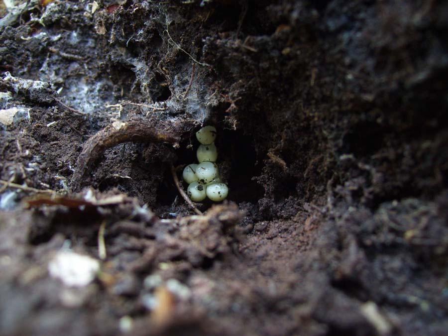
37 Nathaniel Mountain WMA Two P. cinereus were located at separate sites in Nathaniel Mountain WMA (Figure 19). One site was less than 50 m from a first-order stream that empties into Mill Run, a second-order stream, where P. cinereus was sympatric with P. cylindraceus. The other site was located in a ravine at the base of the northern most extent of South Branch Mountain. This salamander was about 1 km from the nearest P. virginia site to the southwest. Lost River State Park Plethodon cinereus was found at three sites at the base of East Ridge near Howard s Lick Run (Figure 21). Plethodon cylindraceus was sympatric with P. cinereus at two of these sites. As mentioned above, these sites are approximately 500 m from the nearest P. virginia site, which is located along the ridgeline of East Ridge. On 10 June, a female P. cinereus was found guarding a clutch of seven eggs under a rock (Figure 28). The eggs were hanging from what appeared to be a root in an opening in the soil. The eggs were whitish, and embryos did not appear to be far along in development, as the eggs appeared to only contain a whitish fluid. The female was coiled around the eggs. Interestingly, there was another salamander found under the same rock, which had the appearance of a P. virginia, but may have been a lead-back phase P. cinereus as described above. This salamander was not identified to species because it had characteristics that were intermediate to P. virginia and P. cinereus. Beacause P. virginia occur within 500 m of this sight on East Ridge. This could be due to natural variation, or potentially 28
38 hybridization between P. virginia and P. cinereus. Further surveys need to be conducted to determine if P. virginia occurs at this site. The remaining P. cinereus was found at a site about 5 km northwest of Lost River State Park at Helmick rock. Only one P. cinereus was found at this site during a VES in which one P. cylindraceus and 28 P. punctatus were also found. Plethodon cylindraceus Plethodon cylindraceus appears to be the most widespread woodland salamander in the area (Figures 12 & 13), although it was not found as commonly at higher elevations as in lower elevations. Plethodon cylindraceus was found from March through November between 540 and 890 m in elevation and was the only Plethodon found below 870 m between 13 July and 6 September. Historically, P. cylindraceus has been found at high elevations along the Shenandoah Mountain ridgeline, though infrequently (Tucker 1998), but was not found there during 2008 surveys. The highest elevation sites where P. cylindraceus was found during 2008 surveys were along the ridges of Great North Mountain in Hardy County and South Branch Mountain in Hampshire County. Daytime cover searches were the most successful in detecting P. cylindraceus, and rocks were the most used cover objects, as with the other woodland salamanders. George Washington National Forest In the southern part of George Washington National Forest in West Virginia, P. cylindraceus was never found above 800 m, while P. punctatus was the only large Plethodon found at high elevations. In the vicinity of Reddish Knob, only one P. 29
39 cylindraceus was found at one site on 27 March at 794 m elevation (Figure 14). Plethodon cylindraceus was commonly found at the bases of Shenandoah Mountain and the smaller ridges and knobs that run parallel to the west. In this area, P. cylindraceus was frequently found with P. virginia (Figures 16 & 17). In the northern part of George Washington National Forest, along the ridge of Great North Mountain, P. cylindraceus was found at its highest elevation from 2008 surveys at 890 m (also found at this elevation on South Branch Mt. in Hampshire County) on 4 October (Figure 18). This same site area was surveyed one week later when P. punctatus was found; P. cinereus was also found at this site during both surveys. Nathaniel Mountain WMA Plethodon cylindraceus was found at six sites in Nathaniel Mountain WMA in Hampshire County (Figure 19). Within this area, P. cylindraceus was found along the ridge of South Branch Mountain, near two first-order streams that lead into Mill Run and within 10 m of Mill Run, a second-order stream. The individual found close to Mill Run was in a rock crevice in a rock outcrop on a steep slope with numerous rocky outcrops. Plethodon cylindraceus was sympatric with P. virginia at two sites and P. cinereus at one site in Nathaniel Mountain WMA. Three individuals were found at a site just below the ridge of South Branch Mountain in the vicinity of the Nathaniel Mountain lookout tower where P. punctatus has been found historically. 30
40 Short Mountain WMA Plethodon cylindraceus was found at one site in Short Mountain WMA and was the only Plethodon found in this area. It was found at 680 m on 17 May. Historically, P. cinereus has also been found in this area. Lost River State Park Plethodon cylindraceus was found at five sites in Lost River State Park, though the three sites that were in the vicinity of Howard s Lick Run are close enough to be considered one site (Figure 21). In the northernmost area of Lost River State Park, near Miller Rock, two P. cylindraceus were found at 850 m elevation on Big Ridge on 13 July (Figure 20). These were the only Plethodon found after multiple surveys on Big Ridge. Near Howard s Lick Run between Big Ridge and East Ridge, P. cylindraceus was found with P. cinereus at two sites. Plethodon cylindraceus was sympatric with P. virginia on the ridge of East Ridge. Plethodon cylindraceus was also found 5 km to the northwest of Lost River State Park near Helmick Rock on South Branch Mountain where it was found sympatric with P. punctatus and P. cinereus. Monongahela National Forest Surveys were conducted on Cave Mountain, which is in a narrow section of the Monongahela National Forest that lies east of the South Branch Potomac River. Plethodon cylindraceus was found at six sites on Cave Mountain, and was sympatric with P. virginia at two sites (Figure 22). 31
41 Discussion Salamanders in the genus Plethodon in the Valley and Ridge tend to occur on wooded ridges, slopes, and valleys throughout the region, but each of the four species encountered during this study appeared to be distributed in a unique way with regards to landscape characteristics. The patterns of distribution of salamanders belonging to particular sizeguilds as discussed by Grobman (1944), Highton (1972), and Adams (2007) holds true for the woodland salamanders of this region, where two similarly sized species were sympatric at only eight sites, six of which were within close proximity near Reddish Knob, and potentially represent large populations of P. cinereus, P. hoffmani, and P. virginia (or hybrids) (Table 3). Conversely, 29 sites contained two differently sized salamanders. In both Lost River State Park and Nathaniel Mountain WMA, P. cinereus and P. virginia were found to be separated by only a short distance, and both were found with P. cylindraceus at each region (Figure 19). Between the two small species, P. virginia appeared to inhabit the hotter, drier regions, while P. cinereus was found in cooler, moister regions. In Nathaniel Mountain WMA for instance, P. cinereus was only found in areas near streams or in cooler ravines while P. virginia was typically found closer to ridges, which tend to receive greater degrees of insolation, and in turn create hotter and drier meso- and microclimates. These findings support suggestions made by Highton (1972, 1999) regarding the distributions of these two species in relation to climatic factors. In the more southern portion of the range of P. virginia, both P. cinereus and P. virginia have been found near the summit of Shenandoah Mountain, but the two have rarely been found at the same site. Highton (1999) suggested that one species may be encroaching on the range of the other, and that the species that is found in 32
42 isolated populations is likely being replaced by the other. Highton (1972) discussed a possible isolated population of P. cinereus near Moorefield, WV, as possible evidence that P. virginia (then P. hoffmani) may be encroaching on P. cinereus. While it is difficult to determine whether isolated populations of P. cinereus occur in the Valley and Ridge without more thorough surveys, it appears that, instead of occurring in isolated populations, P. cinereus may penetrate the northern regions of the range of P. virginia in relatively moist and cool ravines. One area where P. cinereus does not appear to penetrate into the P. virginia range is just west of the summit of Shenandoah Mountain in Pendleton and southwest Hardy counties where P. virginia has been found. There appear to be three possible trends in the distributional patterns of these two species: 1) that P. virginia, with its larger body size and apparently smaller clutch size is better adapted to the hot, dry region of the valley and ridge (Highton 1999); in areas where its range overlaps with P. cinereus, P. virginia tends to occur on hotter, drier regions within those areas, and neither species is expanding their range, 2) Plethodon cinereus is currently expanding its range into the Valley and Ridge, and has done so more successfully in the cooler, moister areas, which causes regions of range overlap where P. virginia occurs in hotter drier areas, and 3) Plethodon virginia is expanding its range into the range of P. cinereus and has done so more successfully in hotter, drier regions where it is better adapted. If climate is the major factor in shaping the ranges of these salamanders, and trends towards a warmer and drier climate are occurring, it is possible that P. virginia may become better adapted to regions that were once wetter and cooler, and their range may be expanding. Conversely, research on the interspecific interactions of P. cinereus has shown it to be an aggressively superior territorial competitor, 33
43 potentially excluding other salamanders from high quality habitat through aggressive interference (Griffis & Jaeger 2008; Jaeger et al. 2002). However, this has not always been the case, for instance, P. hubrichti, a small endemic Plethodon that has a limited range in the Blue Ridge Mountains in Virginia, is superior in aggressive interactions with P. cinereus (Arif et al. 2007). Future studies that investigate behavioral interactions between P. virginia and P. cinereus, as well as abiotic climatic conditions, could provide insight into the causes of their distribution patterns. There are several localities that were found in this study in which closely occurring populations of P. virginia and P. cinereus could be monitored to determine how biotic and abiotic conditions may differ. Though P. cylindraceus and P. punctatus co-occur in some sites, their distributions are clearly divided by elevation (Table 4; Figure 5). The vertical pattern of distribution of these species has been documented in previous studies (Tucker 1998), and has been discussed with similar species pairs such as P. cylindraceus and P. metcalfi (Hairston 1949) and P. jordani and P. teyahalee (Nishikawa 1985) in North Carolina. To the west of the Valley and Ridge, in the Allegheny Mountains and Plateau, P. wehrlei and P. glutinosus are found at low and high elevations (Pauley 1980; Green & Pauley 1987) and occur in similar habitats (Highton 1972). Within its restricted high elevation distribution, P. punctatus tends to be associated with rocky substrates and especially talus slopes, where it can be locally abundant (Flint & Harris 2005). Tucker (1998) studied the distribution and habitat of P. punctatus and concluded that it either occurs in several relict populations restricted by climatic factors that influence microhabitat characteristics such as such as soil moisture, or from potential competitive interactions with P. cylindraceus. Graham (2007) suggested that P. punctatus possibly became isolated in 34
44 cooler, wetter climates at the tops of mountains during past hot and dry climatic conditions such as the Pliocene Epoch (approximately 2-5 million years before present), and may have been restricted from following the returning cooler moister climates to lower elevations due to competitive pressure from P. cylindraceus, and instead adapted to colder high elevation conditions by using talus slopes where they could burrow deep into the ground. Competitive pressure in the Valley and Ridge may have a greater effect than in the moister and cooler regions of the Allegheny Mountains and Plateau if decreased moisture reduces the density of resources such as food and adequate microhabitat, and may result in the separation of the two species in vertical distribution. In the Allegheny Mountains and Plateau, greater moisture and cooler temperatures may allow species such as P. glutinosus and P. wehrlei to coexist at similar sites. Studies on habitat and behavior of P. wehrlei and P. glutinosus could provide information on potential niche partitioning that allows resources such as food or space two be divided between these similar species. In the Valley and Ridge, the larger P. cylindraceus may be better adapted to hotter and drier conditions (as may be the case for P. virginia and P. cinereus) because of greater protection from desiccation, and may be a superior competitor, but interspecific behavioral studies have not yet been conducted between these species. Conclusions The patterns of distribution of woodland salamanders appear to be non-random in that similarly sized species tend to not co-occur, and that the larger species in each case (P. cylindraceus and P. virginia) appear to inhabit hotter and drier regions. Plethodon 35
45 virginia is widespread throughout its range and occurs at all elevations along high and medium elevation ridges and slopes and ravines, though it was observed in relatively low numbers. Within the range of P. virginia, P. cinereus is restricted to higher elevations along Shenandoah mountain and in cool and moist ravines and slopes near streams in lower elevations. Plethodon punctatus is restricted to high elevation ridges in the area, primarily along the ridge of Shenandoah Mountain, and in several apparently disjunct populations on Jack Mountain, Great North Mountain, and South Branch Mountain. Plethodon cylindraceus is widespread throughout the Valley and Ridge, but is not as common on high elevation ridges where P. punctatus is typically found. 36
46 Table 1. Number and percentage of each Plethodon detected in daytime cover object surveys (DTCS) and visual encounter surveys (VES) from March-November, 2008 in the Valley and Ridge of West Virginia. Species DTCS VES Plethodon punctatus 32 (43%) 42 (57%) Plethodon virginia 43 (90%) 5 (10%) Plethodon cinereus 88 (79%) 24 (21%) Plethodon cylindraceus 61 (84%) 12 (16%) 37
47 Table 2. Number and percentage of each Plethodon found under cover object types from March-November 2008 in the Valley and Ridge in West Virginia. Percentages only include salamanders found under cover, and do not include salamanders that were found active on the surface. Species Rock Log Other* P. punctatus 26 (81%) 4 (13%) LL=1, B=1 P. virginia 39 (91%) 4 (9%) NA P. cinereus 62 (70%) 22 (25%) B=3 P. cylindraceus 50 (82%) 10 (16%) RC=1 * LL=leaf litter, B=bark, RC=rock crevice 38
48 Table 3. Number of sites in which species were found at the same site in all surveys from March-November, 2008 in the Valley and Ridge in West Virginia. Species P. cylindraceus P. virginia P. cinereus P. hoffmani x virginia P. punctatus P. cylindraceus P. virginia P. cinereus
49 Elevation (m) P. cinereus P. virginia P. cylindraceus P. punctatus Figure 5. Elevational distribution of sites occupied by woodland salamanders in the Valley and Ridge in West Virginia,
50 Table 4. Number of Plethodon salamanders detected by elevational range from all surveys from March-November, 2008 in the Valley and Ridge in West Virginia. Elevation (m) P. punctatus P. cylindraceus P. virginia P. cinereus <
51 Table 5. Inventory of amphibians and reptiles located in the George Washington National Forest in surveys from March-November, 2008 in Pendleton and Hardy counties in West Virginia. Taxon n County Habitat and notes Caudata Eurycea bislineata 1 Pendleton Hillside by stream Notophthalmus v. viridescens 16 Pendleton, Hardy Wooded hillsides and ridges (efts) Plethodon cinereus 106 Pendleton, Hardy High elevation ridges and slopes Plethodon cylindraceus 28 Pendleton, Hardy Wooded hills, ravines, and ridges Plethodon punctatus 46 Pendleton, Hardy High elevation ridges and slopes, rocky Plethodon virginia 33 Pendleton Wooded hillsides and ridges Plethodon hoffmani x virginia* 14 Pendleton High elevation ridges and slopes Pseudotriton ruber (adult) 1 Pendleton Wooded hillside Anura Rana clamitans Rana palustris 1 Pendleton Near woodland pond (possibly ephemeral) 1 Pendleton Near woodland pond (possibly ephemeral) Squamata Diadophis punctatus edwardsii 2 Pendleton, Hardy Wooded hillside Sceloporus undulatus 1 Pendleton Hot, dry ridge-top * Represents individuals from zone of hybridization (Highton 1999), genetic analysis is necessary to adequately identify individuals to species 42
52 Table 6. Inventory of amphibians and reptiles located in Lost River State Park in surveys from May-October, 2008 in Hardy County, West Virginia. Taxon n Habitat and notes Caudata Notophthalmus v. viridescens 2 Wooded hillsides and ridges (efts) Plethodon cinereus 3 Wooded hillside near stream Plethodon cylindraceus 12 Wooded hills, ravines, and ridges Plethodon virginia 4 Wooded ridge 43
53 Table 7. Inventory of amphibians and reptiles located in the Nathaniel Mountain Wildlife Management Area in surveys from May-October, 2008 in Hampshire County, West Virginia. Taxon n Habitat and notes Caudata Notophthalmus v. viridescens 2* Wooded hillsides and ridges (efts) *(also larvae in a breeding pool) Plethodon cinereus 2 Wooded ravine, near stream Plethodon cylindraceus 19 Wooded hills, ravines, and ridges Plethodon virginia 6 Wooded hillsides ravines and ridges Squamata Diadophis punctatus edwardsii 1 Syntopic w/ P. cylindraceus under rock on hillside 44
54 Table 8. Inventory of amphibians located in Short Mountain Wildlife Management Area in surveys in May 2008 in Hampshire County, West Virginia. Taxon n Habitat and notes Caudata Notophthalmus v. viridescens Several Adults in breeding pool Plethodon cylindraceus 1 Flat wooded area Anura Bufo americana 5 2 adults in amplexus, 3 adults in amplexus, in shallow pools with eggs Hyla versicolor 2-3 Trees around shallow pools, captured 1 Pseudacris crucifer Several Shallow wetland/flooded field, 2 adults found in amplexus Pseudacris feriarum Several Shallow wetland/flooded field, identified by call Rana clamitans Several Wetland, identified by call 45
55 Table 9. Inventory of amphibians and reptiles located in the Monongahela National Forest in surveys from June-September, 2008 in Pendleton County, West Virginia. Taxon n Habitat and notes Caudata Notophthalmus v. viridescens 2 Wooded hillside (efts) Plethodon cylindraceus 12 Wooded hillsides Plethodon virginia 5 Wooded hillsides Anura Bufo americana 1 Wooded hillside 46
56 Table 10. Inventory of amphibians and reptiles located in the Valley and Ridge in West Virginia in remaining sites in Taxon n County/area Habitat and notes Caudata Ambystoma maculatum 1 Hampshire, Edward s Run WMA Notophthalmus v. viridescens 2 Hardy, Helmick Rock; Hampshire, Edward s Run Hillside by flooded field and ponds Wooded hillsides and ridges (efts) WMA Plethodon cinereus 1 Hardy, Helmick Rock Talus slope Plethodon cylindraceus 1 Hardy, Helmick Rock Talus slope Plethodon punctatus 28 Hardy, Helmick Rock Talus slope Anura Bufo americana 1 Hampshire, Edward s Run Wooded hillside WMA Bufo fowleri 1 Hardy, South Branch WMA Sandy riverbank Squamata Coluber c. constrictor 1 Pendleton Roadkill Elaphe obsoleta 2 Hardy, South Branch WMA Hardy: roadkill SBWMA: juv. in weedy old field Testudines Chrysemys picta 4 Hampshire, Edward s Run WMA Basking on exposed log in pond 47
57 Figure 6. Current and historic site localities of Plethodon punctatus in West Virginia. Sites were compiled from the United States National Museum of Natural History records, past surveys by TK Pauley (1995, 1998), Marshall University graduate students (Tucker 1998, Graham 2007), and 2008 surveys conducted for this study. 48
58 Figure 7. Site records for Plethodon punctatus in West Virginia from 2008 surveys. 49
59 Figure 8. Current and historic site localities of Plethodon virginia in West Virginia. Sites were compiled from the United States National Museum of Natural History records, past surveys by TK Pauley (1995, 1998), Marshall University graduate students (Tucker 1998, Graham 2007), and 2008 surveys conducted for this study. 50
60 Figure 9. Site records for Plethodon virginia in West Virginia from 2008 surveys. 51
, Marshall University graduate students (Tucker 1998,")
61 Figure 10. Current and historic site localities of Plethodon cinereus in Pendleton, Hardy, and Hampshire counties, West Virginia. Sites were compiled from the United States National Museum of Natural History records, past surveys by TK Pauley (1995, 1998), Marshall University graduate students (Tucker 1998, Graham 2007), and 2008 surveys conducted for this study. 52

62 Figure 11. Site records for Plethodon cinereus in West Virginia from 2008 surveys. 53
, Marshall University graduate students")
63 Figure 12. Current and historic site localities of Plethodon cylindraceus in West Virginia. Sites were compiled from the United States National Museum of Natural History records, past surveys by TK Pauley (1995, 1998), Marshall University graduate students (Tucker 1998, Graham 2007), and 2008 surveys conducted for this study. 54
64 Figure 13. Site records for Plethodon cylindraceus in West Virginia from 2008 surveys. 55

65 Figure 14. Large Plethodon occurrence sites from the vicinity of Reddish Knob on Shenandoah Mountain from 2008 surveys. 56

66 Figure 15. Small Plethodon occurrence sites in the vicinity of Reddish Knob on Shenandoah Mountain from 2008 surveys. Plethodon hoffmani x virginia localities represent possible hybrids based on the description of the distribution of P. virginia by Highton (1999). 57

67 Figure 16. Plethodon occurrence sites east of Brandywine, WV on Shenandoah Mountain and ridges to the west from 2008 surveys 58

68 Figure 17. Plethodon occurrence sites in the vicinity of Cow Knob on Shenandoah Mountain and ridges to the west from 2008 surveys. 59

69 Figure 18. Plethodon occurrence sites on the ridge of Great North Mountain, East of Basore, WV from 2008 surveys 60

70 Figure 19. Plethodon occurrence sites from Nathaniel Mountain Wildlife Management area from 2008 surveys. The P. punctatus site shown is a historic site. 61

71 Figure 20. Large Plethodon occurrence sites from Lost River State Park and Helmick Rock to the northwest (where P. cinereus was also found) from 2008 surveys. 62

72 Figure 21. Plethodon occurrence sites in the vicinity of East Ridge in Lost River State Park from 2008 surveys. 63

73 Figure 22. Plethodon occurrence sites from Monongahela National Forest on Cave Mountain from 2008 surveys. 64

74 Figure 23. Plethodon punctatus found on Great North Mountain, Hardy County, WV, November

75 Figure 24. Picture of site where Plethodon punctatus was found on Great North Mountain, Hardy County, WV, November

76 Figure 25. Plethodon virginia, Pendleton County, WV, May

77 Figure 26. Plethodon virginia found on an eastern slope of Heavener Mountain, Pendleton County, WV, March


78 69
79 Figure 27. Juvenile salamander that may represent a red-striped Plethodon virginia or a Plethodon cinereus at the base of Heavener Mountain, Pendleton County, WV, March 2008 (previous page). Figure 28. Female Plethodon cinereus guarding eggs attached to a root under a rock in Lost River State Park, Hardy County, WV, June 2008 (following page). 70

80 71
81 CHAPTER THREE Multi-model Evaluation of the Patterns of Woodland Salamander Distribution in the Valley and Ridge Physiographic Province Abstract Two woodland salamanders, Plethodon punctatus and P. virginia, are endemic to the Valley and Ridge Physiographic Province in West Virginia and Virginia and occupy limited geographic ranges. Two common and widespread species, P. cylindraceus and P. cinereus, also inhabit this region. I used two types of modeling to evaluate the distributions of these species with site occupancy data. I used logistic regression to evaluate a priori models that were developed with presence-absence data and associated environmental variables from 2008 surveys and ranked them with Akaike s Information Criterion corrected for small sample size (AIC c ). To develop logistic regression models separately for each species, I used presence absence data from all sites where Plethodon were detected, which resulted in 71 sites for each species. I then used historic and current presence data to model the distribution of each species with the software program Maxent and WorldClim climatic variables. The output of Maxent models produces a map of each species potential distribution. To compile current occurrence data, I used daytime cover object searches and nocturnal visual encounter surveys. Geographic locations were recorded with a GPS receiver. Environmental data including substrate type, elevation, ambient temperature, soil temperature and relative humidity were recorded and used in logistic regression modeling. Logistic regression modeling revealed that P. punctatus and P. cinereus had positive associations with elevation, P. virginia was negatively associated with relative humidity, and P. cylindraceus occurrence was negatively associated with elevation and positively associated with ambient temperature and relative humidity. Maxent distribution models were evaluated and suggested that the distributions of woodland salamanders are likely shaped by both climatic factors as well as biological factors, possibly in the form of competition. Introduction Terrestrial woodland salamanders of the genus Plethodon have been the focus of much research about patterns of species co-occurrence, distributional patterns, and competition (Dunn 1926; Grobman 1944; Highton 1972; Hairston 1987; Adams 2007). The idea that similarly sized Plethodon species tend to have largely parapatric distributions, while differently sized species co-occur more frequently has been observed and subsequently 72
82 evaluated as two size-guilds, comprised of a small Plethodon guild and a large Plethodon guild in which members of a guild tend to occupy similar niches within their ranges (Grobman 1944; Highton 1972; Hairston 1987; Adams 2007; Bruce 2009). Because of these similar niche requirements, similar species tend to not co-occur, while differently sized species tend to co-occur due to the lack of niche overlap. Grobman (1944) described overlapping ranges of differently sized salamanders as geographical equivalents, and referred to two such salamander species as syngeographs. The largely parapatric arrangement of distributions of similarly sized woodland salamanders has led to investigations into the mechanisms that cause such patterns. Several studies have evaluated the role of competition and niche partitioning in the patterns of parapatric and sympatric species within size classes, and have suggested that interspecific aggression and territoriality have had a major role in interference competition leading to the exclusion of species (Jaeger 1981; Nishikawa 1985; Jaeger et al. 2002), though the resource at the center of such competition is not always clear (Hairston 1987). Similarly sized woodland salamanders that have broad distributional overlap may not compete as strongly for resources (Hairston 1987), which may be due to the abundance of resources, such as space and food, combined with density independent causes, such as climatic factors that limit the size of populations, thereby reducing competition (Dumas 1956). Adams (2007) found non-random patterns of co-occurrence that supported the hypothesis that two size guilds occurred in eastern Plethodon that represented a competitive-based community assemblage in a study that included 45 species of eastern Plethodon at 4540 historic sites. Throughout the many studies that have investigated interspecific interactions between woodland salamanders, no one factor 73
83 has emerged as a primary cause for such patterns of distribution, but causes appear to be specific to particular regions that have unique species assemblages, and combinations of environmental factors such as climate, heterogeneous topography, vegetation, and disturbance history. Two endemic species of the genus Plethodon inhabit the Valley and Ridge Physiographic Province in West Virginia and Virginia. This study focuses on the range of these two endemic species, Plethodon virginia (Shenandoah Mountain Salamander) and Plethodon punctatus (Cow Knob Salamander). Plethodon virginia is limited to Pendleton, Hardy, Grant, and Hampshire counties in West Virginia, and western Rockingham County, Virginia. Plethodon punctatus is found in Pendleton, Hardy and Hampshire counties in West Virginia and Augusta, Highland, Rockingham, and Shenandoah counties in Virginia. The two remaining Plethodon species that inhabit this range, P. cylindraceus (White-spotted Slimy Salamander) and P. cinereus (Eastern Redbacked Salamander) are more common and have widespread distributions. Plethodon punctatus is a medium-large salamander that is restricted to high elevations within a narrow range that is represented by a core distribution along the ridge of Shenandoah Mountain on the Virginia-West Virginia border as well as a few disjunct populations on the relatively high-elevation ridges of Jack Mountain in Pendleton County, WV (Graham, 2007), Nathaniel Mountain in Hampshire county, and Great North Mountain on the border of Hardy County, WV and Shenandoah County, VA (Highton 1972; Flint 2004). Because of its narrow and disjunct range it is a species that is of conservation concern. The West Virginia Division of Natural Resources currently lists P. punctatus as an S1 species, which is defined as extremely rare and critically imperiled, 74
84 while in Virginia, P. punctatus is listed as an S2 species (very rare and imperiled) by the Virginia Department of Conservation and Recreation. Globally, P. punctatus is listed as a Near Threatened on the International Union for the Conservation of Nature (IUCN) Red List ( and is listed as a G3 (vulnerable) species by NatureServe due to a small range, high local abundance, and vulnerability to deforestation ( Plethodon virginia is a small eastern Plethodon that inhabits wooded slopes and ridges within a narrow section of the Valley and Ridge. No studies have focused on the ecology and natural history of P. virginia since its description in1999 when Highton split P. virginia from what is now considered its sibling species, P. hoffmani (Valley and Ridge Salamander) based on allozyme data from electrophoretic protein comparisons. Plethodon virginia was studied when it was still considered P. hoffmani prior to 1999 (Fraser 1976a, b) and P. richmondi before 1972 (Highton and Jones 1965) when P. hoffmani was initially described (Highton 1972). Plethodon virginia is listed as an S2 species in both West Virginia and Virginia and G2G3Q globally (where Q denotes questionable taxonomy) by NatureServe and as Near Threatened by the IUCN. Thus, there are two pairs of similarly sized species within the area of focus. Plethodon cinereus and P. virginia represent two small Plethodon and P. cylindraceus and P. punctatus are two large Plethodon, although P. punctatus is noticeably smaller than P. cylindraceus and may be considered to be of intermediate size (Green & Pauley 1987; Petranka 1998). Fraser (1976a) investigated the possibility of competition between adult P. virginia (then P. hoffmani) and juvenile P. punctatus, to determine if differently sized salamanders may compete when they overlap in size at particular life stages. The 75
85 results suggested that variability in seasonal activity patterns between species, and staggered feeding schedules within species largely prevented competitive exclusion from occurring. The interspecific interactions between the species of this area have otherwise not been studied besides observations on the distributions of the species (Highton 1972, 1999; Pauley 1995, 1998; Tucker 1998; Flint 2004; Graham 2007). Highton (1999) suggested that P. virginia may be better adapted to the xeric conditions of the Valley and Ridge than P. cinereus, which have largely parapatric distributions, and are rarely found together. Plethodon punctatus and P. cylindraceus have overlapping ranges, but P. punctatus is limited to high elevations, while the distribution of P. cylindraceus is widespread throughout the area, though is less commonly found at high elevations. Because P. virginia and P. punctatus are endemic to small ranges, information about their distribution, ecology, and interactions with other species are important for their proper management. To characterize the distributions of these four species I used two methods of modeling. First, I evaluated species occurrence with AIC model selection of logistic regression models of presence and absence data with environmental and topographic variables from 2008 surveys. I then used species distribution modeling with both current and historic presence data. While logistic regression models and model selection aim to highlight the variables and their combinations that most successfully predict the occurrence of a particular species, the goal of distribution modeling is generally to map the potential distribution of species based on some set of parameters, which are usually some set of abiotic environmental variables. There has been some debate as to whether species distribution modeling, also called ecological niche modeling, produces an output 76
86 that illustrates a species realized niche or its fundamental niche (Soberon & Peterson 2005; Araujo & Guisan 2006). While distribution modeling typically estimates ranges based on abiotic environmental variables, biotic factors such as the influence of potential competitors or mutualists are inherently and implicitly incorporated into the models (Araujo & Guisan 2006). Because the exclusion of a species due to the presence of a competitor will influence the distribution of that species, the abiotic variables that coincide with its presence will characterize its modeled distribution even if that species could tolerate and thrive in adjacent ranges where they are absent. It seems likely then, that species distribution models will inherently illustrate something that resembles a realized niche of a species rather than the fundamental niche as defined by Hutchinson (1957). The objectives of this study were 1) to establish baseline data on the distribution, habitat, and associated environmental variables of woodland salamanders in the Valley and Ridge of West Virginia with emphasis on the endemic species: P. virginia and P. punctatus, 2) to evaluate patterns of distribution through the development of competing models of species occurrence for woodland salamanders with environmental and topographic explanatory variables at the site level from 2008 surveys, 3) to use current and historic sites to model the distributions of each species based on prevailing climatic data with GIS and distribution modeling software, and 4) to use the resulting information to evaluate distributional patterns of species distributions and occurrence and to develop testable hypotheses to help guide future research. 77
87 Methods & Materials Site Surveys I surveyed for woodland salamanders at 98 sites within the Valley and Ridge Physiographic Province from March to November 2008 using daytime cover object searches and nighttime visual encounter surveys (VES) during or immediately following rain events (Crump & Scott 1994). Daytime cover object surveys consisted of one to two person-hour surveys in which I turned over natural cover objects, primarily rocks and logs, to locate and record salamanders and environmental data. I used VES primarily in plots with very rocky substrates that consisted of talus slopes and slopes with numerous rocky outcrops. Daytime cover object searches are not effective in detecting salamanders in rocky substrates, while VES during wet nights when salamanders may be active on the surface tend to result in higher rates of detection (Crump & Scott 1994, Flint & Harris 2005). I conducted surveys in areas that represented typical habitat of woodland salamanders, which includes forest habitat with some form of natural cover, such as rocks, leaf litter, and woody debris (Welsh and Droege 2001, Wyman 2003). I selected sampling plots in a non-probabilistic manner because of the limited time, resources, and exploratory nature of this study. Because the distribution and ecology of P. virginia has not been studied since its description by Highton (1999), I chose a sampling scheme that allowed maximum coverage of the study area to establish baseline occurrence information for this species. To reduce bias from nonrandom purposive plot selection, I surveyed areas that represented the topographic heterogeneity of the area (i.e., aspect, slope, elevation), and across the study area geographically and temporally (i.e. March- November). 78
88 Upon detection I hand-captured and identified salamanders and placed them in plastic zip-sealed bags to be measured on-site and recorded the geographic locations of each site with a Garmin GPS60 receiver. I measured snout-vent length (SVL) from the anterior end of the snout to the posterior end of the cloaca, tail length from the posterior end of the cloaca to the tip of the tail, and cranial width at the widest part of the jaw. I used spring scales to measure mass. Upon completion of measurements, salamanders were released at the point of capture. Habitat and Environmental Parameters I took data on environmental parameters at each site that was surveyed. I recorded relative humidity and ambient temperature of the exact location of capture by placing a thermo-hygrometer on the surface at which each individual was located. I measured soil temperature with a digital pocket thermometer that was probed approximately 3 cm into the soil at or within the immediate vicinity of the location of each individual. I recorded cover object type (rock, log) and characterized the substrate in which each individual was located with a ranking system based on rockiness and depth of soil. I developed a substrate-ranking system adapted from similar substrate-classification schemes by Jaeger (1970, 1971, 1980) and Fraser (1976a). Jaeger (1970) classified three types of talus slopes based on the ratio of rock to soil and organic mater where: Type I = bare rocks with no soil, Type II = rocky substrate with limited soil and significant humus accumulation, and Type III = talus at base of slope with significant soil accumulation, fewer exposed rocks. Fraser (1976a) ranked substrate from 1-5 based on the volume of space directly beneath cover objects where 1 = a rock that was closely adpressed to the 79
89 ground, and 5 = a large rock with a large amount of space underneath. I developed a scheme where substrate within the immediate vicinity of individual salamanders was scored based on the relative amounts of rock, space, soil, and humus beneath the cover object for daytime cover object searches and directly below the point of capture in VESs. In this scheme, 1 = a rocky substrate with no soil or humus, and only space between and beneath rocks, and 5 = deep soil with few to no rocks. All scores recorded ranged from 1.5 (very rocky with shallow soil deposits) to 4 (deeply packed soil among rocks, with few to no exposed rocks). Logistic Regression Analysis I used logistic regression to develop maximum likelihood models for each species with salamander presence or absence as the binary response variable and the environmental and physical data collected as explanatory variables. Because sites were the sampling units used for comparison, I obtained the mean of each explanatory variable from woodland salamander presence points within each site for analysis. Prior to analysis, I tested for collinearity between the explanatory variables to identify and remove any redundant variables (Pearson s r 0.70). I used the remaining four variables to develop six a priori models for statistical analyses based on review of natural history and habitat requirements of woodland salamanders from literature and evaluation of different combinations of environmental and physical characteristics (Tables 11 & 12). I included all variables in a global model to assess goodness-of-fit (Burnham & Anderson 2002). I employed the same 6 models for each of the species separately with the same 71 sites and environmental data. 80
90 With some exceptions, a distance of greater than 50 m separated sites that were included in logistic regression analysis. Three sites included in analyses were visited twice, and are represented as separate sites in regression analysis because environmental conditions were different in each repeated survey. Because sites were generally visited only once, I was unable to account for detection probability. As a result, sites that represent absence in regression analysis may not indicate true absence, and instead represent the failure to detect a species. I used Akaike s Information Criterion (AIC c ) for model selection. Because the number of sites included in analysis (n = 71) was relatively small compared to the number of parameters (K) used to develop models (i.e., n/k 40) I used AIC corrected for small sample sizes (AIC c ) for model comparison (Burnham & Anderson 2002). I ranked candidate models based on their calculated AIC c values where lower values represent a more parsimonious and therefore stronger model (Burnham and Anderson 2002). I used models with AIC c values within 2 units of the most parsimonious model to draw inferences for each species (Burnham & Anderson 2002). Species Distribution Modeling To model the distribution of each salamander, I used the software program Maxent version (Phillips et al. 2004), which uses presence-only data to model species distributions with some set of environmental variables in raster data layers under the principles of maximum entropy. Phillips et al. (2004) summarized maximum entropy in this context as an estimated probability distribution with maximum uniformity constrained by the empirical averages of each feature (i.e. environmental variables) 81
91 throughout the geographical area of interest, and likened its output to a maximumlikelihood distribution of a species. To develop models for each species, I compiled presence data from 2008 surveys, the Marshall University Herpetology Museum, past studies on the species (Pauley 1995, 1998, Tucker 1998, Graham 2007), and from the Division of Amphibians and Reptiles of the National Museum of Natural History (USNM). Presence data were collected from Pendleton, Hardy and Hampshire counties, WV and Highland, Augusta, Rockingham, and Shenandoah counties, VA (Table 22). Maxent uses random background points within the projected geographical area to represent the range of environmental variables within the area and provides a reference to suitable habitat of the species being modeled. I used the default 10,000 background points. The environmental variables used were climatic variables from the WorldClim database (Hijmans et al. 2005), which are freely available on the internet ( WorldClim data layers are based on average monthly precipitation and temperature data from and are presented in raster format at a 1-km 2 resolution worldwide (Hijmans et al. 2005). To reduce over-parameterization, a model was developed for each species in which all climatic variables were used and reduced to the six variables that contributed most to each model based on a jackknifing procedure and percent contribution (Tables 23-26), both of which are provided within the Maxent output. To determine what effect one species distribution may have on the modeling of another, I used the modeled probability distribution output from similarly sized Plethodon as an additional variable in a separate model of its counterpart s modeled distribution. The resulting output within Maxent provides response curves for each continuous variable against the probability of occurrence based on the environmental 82
92 variables. To reduce autocorrelation, I chose to allow only one presence point per km 2 cell to be included in analyses. Results From March through November 2008, 321 woodland salamanders were recorded at 91 sites including 74 P. punctatus at 23 sites, 48 P. virginia at 33 sites, 112 P. cinereus at 22 sites and 73 P. cylindraceus at 38 sites; 25 sites had more than one species. Because P. virginia has a zone of hybridization with a sibling species, Plethodon hoffmani, at the southern extent of its range and the two species are indistinguishable in external characteristics (Highton 1999), sites located within the vicinity of Reddish Knob in Pendleton County (sites: n = 6; individuals: n = 14) possibly represent occurrence of hybrids and were not included in analyses. Regression analysis Statistical analyses included data from the 71 sites that had complete environmental data. Because soil temperature and elevation were found to have a negative linear relationship (Pearson s r < -0.7), soil temperature was not included in the candidate models. The ambient model received the most support among the candidate models in assessing occurrence of P. virginia (Table 13). Relative humidity had a negative relationship with occurrence of P. virginia, (Table 14). Both the elevation and physical models received support in the case of P. punctatus (Table 17), for which elevation had a positive relationship with P. punctatus occurrence (Table 18). The global model ranked 83
93 highest for P. cylindraceus (Table 19), in which air temperature and relative humidity had a positive relationship, while elevation had a negative relationship with occurrence (Table 20). Both the elevation and physical models received support for P. cinereus (Table 15); elevation had a positive relationship with occurrence (Table 16). When Akaike weights (w i ) were summed among models for each species to evaluate the relative importance of each explanatory variable (Table 21), elevation had the greatest weight for P. punctatus, P. cylindraceus, and P. cinereus. Air temperature had the greatest summed weight for P. virginia. It is important to point out that all of the explanatory variables except for relative humidity were included in three of the candidate models while relative humidity was included in only two models. Because of this, the sum of Akaike weights is not balanced between the variables. If, instead, an average weight of each explanatory variable had been taken, relative humidity could have had the greatest average weight for P. cylindraceus and P. virginia. I did not develop a relative humidity-only model because relative humidity is meaningless without temperature. Species Distribution Modeling The species distribution models for P. virginia (Figure 29) and P. punctatus (Figure 33), the two endemic species, produced maps that showed distinct ranges, while the P. cinereus range map was more scattered and less distinct (Figure 31). The P. cylindraceus map had a distinct and widespread area of high probability of occurrence (Figure 35). Because the vast majority of the data collected came from public lands (e.g., George Washington National Forest) within the mountainous area of the Valley and Ridge, the resulting maps showed similar southwest to northwest patterns that followed the 84
94 characteristic long parallel ridges and valleys of the Valley and Ridge. While the output provided plausible maps for P. punctatus and P. virginia, the known ranges of P. cinereus and P. cylindraceus extend well beyond the area considered, and sampling bias likely plays a part in their maps that show a more limited range of suitable habitat. Each species had a unique set of variables that were considered most important from jackknife and percent contribution results. However, P. cylindraceus and P. cinereus had the same variable that contributed most, precipitation in the wettest month (Figures 25 & 27). Plethodon virginia and P. punctatus models also included precipitation of the wettest month, but in each case, it was the second most important variable. The most important variable in the P. virginia model was mean temperature of the warmest quarter, while the most important variable for P. punctatus was maximum temperature in the warmest month (Figures 24 & 26). Models for each species with a seventh environmental variable consisting of the distribution model of the similarly sized potential competitor produced output maps that were very similar to the six-variable models. Response curves illustrated the change in a species probability of occurrence as another species probability of occurrence changes (Figures 37-40). In each case, there was a response curve in which the seventh variable (competitor s probability of occurrence) changed while the six remaining variables remained at their average value, and therefore showed the seventh variable s marginal effect (Figures 37 & 39), as well as a response curve for the seventh variable as the sole variable considered in the model (Figures 38 & 40). 85
95 Discussion Small Plethodon The distribution and patterns of occurrence of woodland salamanders in the Valley and Ridge Physiographic Province has been studied and discussed as a function of both competition (Fraser 1976b) and adaptation to climatic regimes (Highton 1972, 1999). Highton (1972, 1999) speculated that P. cinereus is largely absent from a substantial portion of the relatively hot and dry climate of the Valley and Ridge, where P. virginia and P. hoffmani may be better adapted due to greater body size (Fraser 1976b) and smaller clutch size (Angle 1969). Jaeger (1971) found that P. shenandoah, also a larger salamander than P. cinereus, was likely better adapted to the hotter, drier microclimate of talus slopes where P. cinereus was more susceptible to desiccation. Plethodon cinereus was more common in the cooler and moister microclimates of the deeper soil around the talus slopes where Jaeger suggested P. shenandoah was largely absent due to the competitive superiority of P. cinereus. In this study, the ambient model, which aimed to include parameters that described the microclimate, was the best model for P. virginia (Table 13). The negative relationship of relative humidity in predicting P. virginia occurrence from the logistic regression model is consistent with the speculations of Highton (1999) (Table 14). The strength of weight of elevation in the logistic regression models for P. cinereus is consistent with patterns observed in the field (Table 16). Plethodon cinereus was located largely at high elevations on Shenandoah Mountain. However, it is important to note that P. cinereus was also found at lower elevations as well, though at fewer sites. From observations in the field, P. cinereus occupies narrow areas within the 86
96 region of interest along the ridges of the high elevations ( m) of Shenandoah Mountain at 11 sites, or in lower elevations ( m) in valleys and coves in five sites in the northern area of P. virginia s range in Hampshire and northern Hardy counties. One site, on Helmick Rock in Hardy County, WV is a relatively high elevation site (880 m) where P. punctatus was also found. All remaining sites where P. cinereus was found in 2008 surveys are outside of the known range of P. virginia. By contrast, P. virginia tends to inhabit the drier slopes of Shenandoah Mountain as well as high elevations along the ridge, and were the only woodland salamanders found on the drier ridges that run parallel to the west of Shenandoah Mountain. The Maxent species distribution models for P. virginia and P. cinereus result in two contrasting maps. The map for P. virginia is a clearly defined range that may be a plausible actual range of the salamander. This map only excludes occurrence data from the far western edge of its range, which are each just east of the South Branch of the Potomac River, and at one location at the far northern extent of its range where more surveys may be warranted (Figure 29). One area where P. virginia has not been recorded and shows a high suitability is in the vicinity of Great North Mountain in Hardy County. Highton (1999) suggests that the Cacapon River, (Lost River directly west of Great North Mountain) is a likely boundary to P. virginia. The area of greatest overlap appears to be along the ridgeline of Shenandoah Mountain and the area to the immediate east in Virginia, where both species have been found. In the output map for P. cinereus, the suitability of habitat appears to quickly decline west of the ridge of Shenandoah Mountain (Figure 31), while the modeled P. virginia suitability remains strong. Within this general area, except in far south Pendleton County, P. cinereus has not been found 87
97 between the South Branch Potomac River and the ridge of Shenandoah Mountain, where P. virginia has been found and shows the widest area of relatively suitable habitat. It would appear that in this region, P. virginia excludes P. cinereus. Conversely, there appears to be overlap to the east of Shenandoah Mountain and in the northern part of P. virginia s range. The response curves for these salamanders when the potential competitor s distribution model is used as a seventh variable illustrate the nature of the ranges of the two salamanders, with P. virginia s range being characterized as restricted geographically and P. cinereus as the more widespread species (Figures 37 & 38). The overall shapes of the curves are somewhat similar to the curves for P. punctatus and P. cylindraceus, also characterized by one restricted range (P. punctatus) and one widespread range (P. cylindraceus) (Figures 39 & 40). However, the response curve of P. cinereus that displays the change in suitability across the suitability of P. virginia, with all other variables at their respective average (Figure 37b), shows an extreme decline in P. cinereus suitability with increasing P. virginia suitability. This would suggest that in otherwise suitable habitat (i.e. the 6 original variables at their average values), areas where P. virginia are well suited are relatively poorly suited for P. cinereus. The fact that P. virginia is restricted to the relatively hot and dry area of the Valley and Ridge, while P. cinereus can be found outside of this range, implies that either P. cinereus is less well adapted to such climatic conditions, or that the presence of P. virginia precludes the presence of P. cinereus (Figure 37b). The response curve of P. virginia distribution, with P. cinereus probability of occurrence as the seventh variable (Figure 37a), shows very low suitability for P. virginia 88
98 in areas where the P. cinereus model shows low to moderate suitability. This is expected because the modeled and actual distribution of P. cinereus extends well outside of P. virginia s distribution, where P. cinereus showed low to moderate suitability. Plethodon virginia s probability of occurrence rises steeply where P. cinereus has a higher probability of occurrence. Because P. virginia was found in areas where P. cinereus had a high probability of occurrence, such as the area along Shenandoah Mountain, this response curve shows a positive association. The response curves in which potential competitors distribution models are the sole variable used both show positive relationships, but with different shapes (Figure 38). The trend suggests that low to moderately suitable habitat for P. cinereus is poorly suited for P. virginia, while poorly suitable habitat to P. virginia is suitable to P. cinereus. This is likely a function of the widespread distribution of P. cinereus across climatic regimes throughout the area compared to the restricted distribution of P. virginia. The important distinction between the two sets of curves is that one set shows the change in a potential competitor s suitability while other environmental variables are held constant, which constrains the resulting curve to suitable habitat based on the other six environmental variables because those values being held constant are averages from presence localities. Curves showing only the potential competitor s probability of occurrence do not factor in the other six environmental variables, and are therefore less constrained. Past studies into the relationships of similarly sized woodland salamanders have found comparable patterns of limited co-occurrence, and have investigated sympatric and allopatric populations. Morphological character displacement was found to occur between P. cinereus and P. hoffmani in which P. hoffmani has apparently become better 89
99 adapted in exploiting larger prey items than P. cinereus when the two species occur in sympatry (Adams & Rohlf 2000). Jaeger et al. (2002) investigated interspecific aggression between P. cinereus and P. hoffmani, and found that P. cinereus is the more aggressive and territorial salamander. They suggested two possible conclusions about the narrow area where the distributions of the two species are largely parapatric. First, P. cinereus is possibly expanding its range into the range of P. hoffmani because it is superior in aggressive interspecific interactions and second, that contact boundaries may be static if P. hoffmani is exploitatively superior in foraging, which could counteract the aggressive superiority of P. cinereus. However, they do not account for the fact that the larger body size and smaller clutch size of P. hoffmani may make it better adapted to the hotter, drier climate of the Valley and Ridge (Highton 1972, 1999), which could be another possible explanation of a relatively static parapatric contact zone between the two species. Woodland salamanders have been found to partition habitat based on moisture regimes (Jaeger 1971; Pauley 1978), so it is possible that these two species may be able to coexist with overlapping ranges that provide heterogeneous conditions that allow them to avoid competition and to only rarely co-occur. Plethodon virginia appears to have a similar relationship with P. cinereus as P. hoffmani; their distributions are largely parapatric, and P. virginia is more widespread in the relatively xeric ridges and slopes of the Valley and Ridge. If P. cinereus is the more successful aggressive competitor, but P. virginia and P. hoffmani are better adapted to xeric conditions, the invasion of one species into the range of another is likely to depend largely on climate. The fact that the range of P. cinereus surrounds the ranges of P. virginia and P. hoffmani would suggest that it may be encroaching on their historic ranges. However, this could also be an 90
100 artifact of past climates, and with current changes in climate towards warmer conditions, it is possible that the encroachment has slowed or even the reversed, and the range of P. cinereus could be receding in the Valley and Ridge. More long-term climatic and occupancy data are needed to investigate this reasoning. The use of environmental dataloggers used in a probabilistic sampling scheme at P. cinereus and P. virginia sites would likely produce more definite results regarding the adaptation of P. virginia and P. hoffmani to more xeric climatic conditions. The use of GIS to evaluate the topography of P. cinereus and P. virginia presence sites could analyze topographic features (aspect, slope, elevation, curvature) which can provide information on important climatic variables such as insolation, which can have an effect on microclimate, and habitat partitioning (Pauley 1978). Large Plethodon The elevation model was not surprisingly the best for P. punctatus (Table 17), which is typically found above 950 m, though has been found at 732 m (Buhlmann et al. 1988). Though substrate was the only other variable that contributed to supported models, confidence intervals were too wide to infer statistical support for the negative relationship according to parameter estimates and odds ratios (Table 18). However, past studies and reports in literature (Green & Pauley 1987; Buhlmann et al. 1988; Flint & Harris 2005) as well as implications from surveys in the current study suggest that there is a strong correlation between P. punctatus and rocky substrates such as talus that are associated with rock outcrops. Because the substrate was evaluated only within the immediate vicinity of the salamander captured, and not on the overall substrate across a 91
101 representative population, the substrate value given may be more dependent on the greater ability to detect individuals in areas with deeper soil and less space between rocks. In daytime cover object surveys, P. punctatus are easier to detect in areas of deeper soil that surround areas of talus (Flint & Harris 2005). Because relatively fewer nighttime surveys in areas of talus were conducted where P. punctatus was found in very rocky substrates (i.e. substrate = 1.5), the values are not likely to be representative of true associations. Measures of distance from a talus slope or a subjective characterization of the overall habitat of a wider area (i.e. across the plot surveyed) would likely have been more representative of the association of P. punctatus with rocky substrates. The global model received the most support in the case of P. cylindraceus (Table 19), which is likely because three of the four parameters had statistically-supported effects on the prediction of occurrence (Table 20). Based on field observations, P. cylindraceus appears to be the most widespread species in the region. While P. cylindraceus occupies all elevations in the area, it appears to be more common at lower elevations, a finding that this model supports. This salamander also appears to be especially common in valleys and ravines that are often within the vicinity of streams, which may account for the positive effect of relative humidity on occurrence, though P. cylindraceus were also found less commonly on drier slopes and ridges. Plethodon cylindraceus was the only salamander to have a statistically supported positive effect of air temperature on occurrence, which is likely because it was the most commonly located salamander in the warm summer months. Distribution maps produced with Maxent models show clearly the restricted nature of P. punctatus distribution (Figure 33) and the widespread distribution of P. 92
102 cylindraceus (Figure 35). The modeled range of P. punctatus also illustrates the disjunct nature of its range. Areas of high probability that have few occurrence localities, such as South Branch Mountain, Jack Mountain and Great North Mountains may not have been sufficiently sampled to determine the extent of P. punctatus s distribution, and may be under-sampled because much of the land is privately owned (Pauley 1998, Graham 2007). Other areas that show high suitability where P. punctatus has not been found and may be under-sampled are Simmons Mountain, Panther Knob, Ruleman Mountain, and other peaks in their vicinity, which are all located to the west of Jack Mountain in western Pendleton County. The remaining area that shows high suitability is to the northwest of the Jack Mountain site near Dickinson Mountain and the associated knobs and ridges. Conversely, P. cylindraceus are distributed throughout the area, which is illustrated clearly in its modeled distribution. The response curves of P. punctatus and P. cylindraceus are indicative of a widespread species and a highly restricted species, but the curve for P. cylindraceus does not show a distinct drop-off in suitability with increasing P. punctatus suitability as P. cinereus showed with P. virginia, but instead continues to rise (Figures 39 & 40). Plethodon punctatus shows a slight drop in suitability across high P. cylindraceus suitability. As expected, low P. punctatus probability of occurrence shows a high level of suitability for P. cylindraceus, while only high probability areas for P. cylindraceus appear suitable for P. punctatus. In this case, both types of response curves (with and without the six environmental variables included) for each species are similar. This is likely because P. punctatus does not exclude P. cylindraceus from any considerable amount of geographical space as P. virginia does with P. cinereus. However, P. 93
103 cylindraceus is much less common in the narrow region of the higher elevations of Shenandoah Mountain where P. punctatus is relatively common. This high elevation region is considerably cooler and moister relative to the general hot and dry climate of the Valley and Ridge. The question then is does P. cylindraceus prevent P. punctatus from expanding its range due to competitive pressure or is P. punctatus poorly adapted to the predominately hot and dry Valley and Ridge? While P. cylindraceus is found at all elevations, it seems to be associated with the relatively lower elevations within the area. The tendency for large Plethodon to be separated altitudinally is not uncommon. Hairston (1949) found that P. cylindraceus and P. metcalfi were largely separated altitudinally in the Black Mountains of North Carolina, where P. metcalfi occupies high elevations. Subsequent studies (Hairston 1951; Highton & Peabody 2000) showed that salamanders of the P. jordani group that occur at high elevations in the southern Appalachians tend to replace members of the P. glutinosus group, which occur within the same areas but at lower elevations. On mountains where P. jordani complex salamanders do not occur, P. glutinosus species tend to occupy all elevations (reviewed in Wells 2007). This is not always the case. For instance, in the Balsam Mountains of North Carolina P. metcalfi (of the P. jordani complex) tends to overlap greatly in altitudinal distribution with P. teyahalee (of the P. glutinosus complex) (Hairston 1980). Nishikawa (1985, 1987) found that P. jordani and P. teyahalee, which had little elevational overlap in the Great Smoky Mountains, showed more interspecific aggression than P. metcalfi and P. teyahalee from the Balsam Mountains which were consistent with Hairston s findings that competition for resources drove such patterns of distribution (Hairston 1980). Marvin (1998) found that two widely sympatric species, P. 94
104 glutinosus and P. kentucki were both equally aggressive to conspecifics as they were to heterospecific individuals, and that P. glutinosus was the superior aggressor. While P. cylindraceus and P. punctatus have been found syntopically (Mitchell and Pauley 2005), and were found together at two sites in this study, it is clear that they do not commonly co-occur. Because P. punctatus tends to inhabit high elevation areas within talus at the highest densities (Flint & Harris 2005), while P. cylindraceus is more commonly found at lower elevations and seems to inhabit a wider variety of substrates, niche partitioning, character displacement, and aggressive interactions should be investigated to provide insight into their ecological relationship. Co-occurring P. glutinosus and P. wehrlei (a sibling species of P. punctatus) to the Alleghenies in West Virginia could be used to investigate interspecific reactions across species complexes and physiographic provinces. Whether the disjunct and limited elevational distribution of P. punctatus is partially a factor of interspecific interactions may be difficult to determine based on environmental and distributional data alone. Buhlmann et al. (1988) suggest that one possible reason for the disjunct distribution and talus-specific habitat of P. punctatus is the repeated timber harvesting throughout much of its range in the early 20 th century. Human disturbance within the area likely has an effect on the distribution of these salamanders as has been shown in other woodland salamanders (Petranka et al. 1993; Marsh & Beckman 2004, Pauley 2008). Conclusions Because the logistic regression aspect of this study was exploratory and sites were visited only once, caution must be used in interpreting the results. However, the results are 95
105 likely to be useful in designing future studies that investigate the mechanisms that drive the apparent patterns of distribution of woodland salamanders in the Valley and Ridge. With information on the distribution of these species, future studies should select sites in a probabilistic manner and visit them multiple times in a season to account for imperfect detection to develop reliable estimates of habitat associations and population and relative abundance parameters (Hyde & Simons 2001, 2005; MacKenzie et al. 2002; Bailey et al. 2004). It is also important to consider that parameters such as relative humidity and ambient temperature are dependent on the day and time measurements are taken, and generally have an impact on whether a species is active or inactive. I conducted surveys regardless of the weather conditions in daytime cover object surveys, and after or during rains for VESs. Plethodon virginia and P. cylindraceus occurrence were found to be affected by these ambient variables. Because relative humidity and temperature are important in the activity patterns of woodland salamanders in general, and this study included only sites where woodland salamanders were present, I believe that the associations with relative humidity and temperature are not only a function of seasonal and daily activity, but on site characteristics that affect long-term microhabitat conditions as well. Afore-mentioned suggestions for monitoring of salamanders and environmental parameters will likely result in estimates that can be interpreted with greater confidence. The results of this study are consistent with the past observations that similarsized woodland salamanders tend to have parapatric distributions (Grobman 1944; Highton 1972; Adams 2007), though they do not allow me to suggest whether interspecific competition is the cause of this apparent distribution pattern in the Valley and Ridge. While the Valley and Ridge is a hotter and drier area compared to 96
106 surrounding physiographic provinces (Highton 1972; Strausbaugh & Core 1978), further studies are needed to investigate whether P. virginia is better suited for such a climate than P. cinereus, or if P. cinereus is likely encroaching on the range of P. virginia. If populations of P. cinereus on the ridge of Shenandoah Mountain and elsewhere in the Valley and ridge are isolated in moister areas, then it would seem more likely that P. cinereus is only able to maintain territory in areas of greater moisture, and its apparent superiority in aggressive interactions with similar-sized Plethodon allow those populations to persist. The existence of isolated P. cinereus populations may be a result of major climatic fluctuations over the past millions of years that have likely driven evolution and in part shaped distributional patterns of woodland salamander distribution (Highton 1972, 1995, 1999; Hairston 1987; Kozak & Weins 2006) and may be an indication of past invasions of P. cinereus into the Valley and Ridge. However, if the P. cinereus populations within the range of P. virginia are continuous with outside populations, there may be evidence that P. cinereus is expanding its range into the Valley and Ridge. Future studies should employ long-term monitoring of sympatric and allopatric populations of P. virginia and P. cinereus along with environmental variables to characterize their habitat with a specific focus on climatic factors. Aggression trials (Jaeger et al 2002), reciprocal transplants (Cunningham et al. 2009), and other ecological experiments into species interactions and environmental tolerance could provide insight into what shapes species distributions in this region. Interspecific interactions between P. cylindraceus and P. punctatus should also be investigated with competition experiments that include other salamanders from their species complexes (i.e. P. glutinosus and P. wehrlei) to evaluate differences in behavior 97
107 between populations that overlap in elevational distribution and populations that do not appear to overlap. Because P. punctatus has such a limited and disjunct distribution, it is a species of particular concern, and information on the mechanisms that limit its distribution is important for management of the species. Plethodon virginia is a species that has only recently been described (Highton 1999), and also has a limited range, so information on its distribution and ecology are important to establish a baseline for future studies and management. 98
108 Table 11. Variables measured at the 71 Plethodon occurrence sites included in logistic regression analysis in 2008 surveys. Variable n Abbrev. Mean SD Min Max Air temperature ( C) 71 AT Relative humidity (%) 71 RH Elevation (m) 71 EL Substrate* 71 SU *Substrate is an interval variable (at intervals of 0.5) where 1=rocky substrate with no soil and 5=deep soil with little to no rock. 99
109 Table 12. Description and justification of a priori regression models. Model name Variables a Justification Ambient RH, AT Microclimatic variables are important to woodland salamander activity, species may be adapted to certain climatic regimes. Temperature AT May be important in woodland salamander activity, species may be adapted to certain temperature regimes. Physical EL, SU Woodland salamander species may be adapted to areas of particular topography and geology. Elevation EL Woodland salamander species may have distributions restricted to particular elevational range. Substrate SU Woodland salamander species may be adapted to substrate types concerning ratio of rocks, interstitial spaces and soil. Global RH, AT, EL, SU This model is used to assess all variables on woodland salamander occurrence and to test goodness of fit (Burnham and Anderson 2002). a RH = relative humidity; AT = ambient temperature; EL = elevation; SU = substrate type 100
110 Plethodon virginia Table 13. A priori logistic regression models, listed in order of parsimony by Akaike s Information Criterion adjusted for small sample size (AIC C ), predicting the presence of Plethodon virginia in the Valley and Ridge Physiographic Province in West Virginia, Model a -2 log likelihood K b AIC C c AIC C d w i e Ambient (AT, RH) Substrate (SU) Global (AT, RH, SU, EL) Temperature (AT) Elevation (EL) Physical (SU, EL) a Six candidate models were developed with 4 explanatory variables: AT = ambient temperature, RH = relative humidity, SU = substrate, EL = elevation b Number of parameters included in each model c Akaike s Information Criterion adjusted for small sample sizes d The difference in AIC C score between the best model and each subsequent model e Akaike weights: probability that a model is the best among all candidate models 101
111 Plethodon virginia Table 14. Parameter estimates ( ) and odds ratios of parameters of logistic regression model predicting the presence of Plethodon virginia in the Valley and Ridge Physiographic Province of West Virginia. The ambient model was the only model that received empirical support ( AIC C 2.00). Model SE Odds ratio a 95% CI b Ambient c RH* AT a Odds ratios 1 indicate a positive interaction in predicting presence and odds ratios 1 indicate a negative interaction b Odds Ratios with 95% confidence intervals that do not include 1.0 have statistical support c Model with most support *P < 0.05 **P <
112 Plethodon cinereus Table 15. A priori logistic regression models, listed in order of parsimony based on Akaike s Information Criterion adjusted for small sample size (AIC C ), predicting the presence of Plethodon cinereus in the Valley and Ridge Physiographic Province in West Virginia, Model -2 log likelihood K AIC C AIC C w i Elevation (EL) Physical (SU, EL) Global (AT, RH, SU, EL) Temperature (AT) Ambient (AT, RH) Substrate (SU) a Six candidate models were developed with 4 explanatory variables: AT = ambient temperature, RH = relative humidity, SU = substrate, EL = elevation b Number of parameters included in each model c Akaike s Information Criterion adjusted for small sample sizes d The difference in AIC C score between the best model and each subsequent model e Akaike weights: probability that a model is the best among all candidate models 103
113 Plethodon cinereus Table 16. Parameter estimates ( ) and odds ratios of parameters of logistic regression model predicting the presence of Plethodon cinereus in the Valley and Ridge Physiographic Province of West Virginia. Two models received empirical support ( AIC C 2.00). Model SE Odds ratio a 95% CI b Elevation c EL* Physical EL* SU a Odds ratios 1 indicate a positive interaction in predicting presence and odds ratios 1 indicate a negative interaction b Odds ratios with 95% confidence intervals that do not include 1.0 have statistical support c Model with most support *P < 0.05 **P <
114 Plethodon punctatus Table 17. A priori logistic regression models, listed in order of parsimony based on Akaike s Information Criterion adjusted for small sample size (AIC C ), predicting the presence of Plethodon punctatus in the Valley and Ridge Physiographic Province in West Virginia, Model -2 log likelihood K AIC C AIC C w i Elevation (EL) Physical (SU, EL) Ambient (AT, RH) Substrate (SU) Temperature (AT) Global (AT, RH, SU, EL) a Six candidate models were developed with 4 explanatory variables: AT = ambient temperature, RH = relative humidity, SU = substrate, EL = elevation b Number of parameters included in each model c Akaike s Information Criterion adjusted for small sample sizes d The difference in AIC C score between the best model and each subsequent model e Akaike weights: probability that a model is the best among all candidate models 105
115 Plethodon punctatus Table 18. Parameter estimates ( ) and odds ratios of parameters of logistic regression model predicting the presence of Plethodon punctatus in the Valley and Ridge Physiographic Province of West Virginia. Two models received empirical support ( AIC C 2.00). Model SE Odds ratio a 95% CI b Elevation c EL*** Physical EL*** SU a Odds ratios 1 indicate a positive interaction in predicting presence and odds ratios 1 indicate a negative interaction b Odds ratios with 95% confidence intervals that do not include 1.0 have statistical support c Model with most support *P < 0.05 **P <
116 Plethodon cylindraceus Table 19. A priori logistic regression models, listed in order of parsimony based on Akaike s Information Criterion adjusted for small sample size (AIC C ), predicting the presence of Plethodon cylindraceus in the Valley and Ridge Physiographic Province in West Virginia, Model -2 log likelihood K AIC C AIC C w i Global (AT, RH, SU, EL) Elevation (EL) Physical (SU, EL) Temperature (AT) Ambient (AT, RH) Substrate (SU) a Six candidate models were developed with 4 explanatory variables: AT = ambient temperature, RH = relative humidity, SU = substrate, EL = elevation b Number of parameters included in each model c Akaike s Information Criterion adjusted for small sample sizes d The difference in AIC C score between the best model and each subsequent model e Akaike weights: probability that a model is the best among all candidate models 107
117 Plethodon cylindraceus Table 20. Parameter estimates ( ) and odds ratios of parameters of logistic regression model predicting the presence of Plethodon cylindraceus in the Valley and Ridge Physiographic Province of West Virginia. Only the global model received empirical support ( AIC C 2.00). Model SE Odds ratio a 95% CI b Global c RH* AT* EL** SU a Odds ratios 1 indicate a positive interaction in predicting presence and odds ratios 1 indicate a negative interaction b Odds ratios with 95% confidence intervals that do not include 1.0 have statistical support c Model with most support *P < 0.05 **P <
118 Table 21. Sum of Akaike weights ( w i ) for each variable, indicating the relative importance of explanatory variables across models for each species where AT = air temperature, RH = relative humidity, EL = elevation, SU = substrate. Because relative humidity was used in only 2 models while all other variables were used in 3, it does not have an equally represented Akaike weight in this table. Variable P. punctatus P. cylindraceus P. virginia P. cinereus AT RH EL SU
119 Table 22. Sources and numbers of presence sites for each species, and number of training sites in used in Maxent models with only one presence point per cell. Species Marshall 1 USNM Total Training 4 P. punctatus P. virginia P. cinereus P. cylindraceus Marshall University Herpetological Museum (West Virginia Biological Survey) 2 Division of Amphibians and Reptiles, National Museum of Natural History 3 Sites surveyed from March-November Sites used when only one site per 1km 2 is used for training 110

120 Figure 29. Plethodon virginia species distribution model. 111
121 Table 23. Six variables used in final species distribution model for Plethodon virginia and percent contribution to the gain of the model. Variable Percent contribution Mean temp warmest quarter 32.3 Precipitation wettest month 30.2 Temp seasonality 19.9 Annual mean temp 8.2 Precipitation coldest quarter 7.1 Min temp coldest month

122 Figure 30. Jackknife results depicting the relative importance of each variable from Plethodon virginia distribution models run with each variable as the only variable in the model, and models run without one variable. 113

123 Figure 31. Plethodon cinereus species distribution model. 114
124 Table 24. Six variables used in final species distribution model for Plethodon cinereus and percent contribution to the gain of the model. Variable Percent contribution Precipitation wettest month 28.0 Max temp warmest month 25.4 Temp annual range 22.0 Temp seasonality 16.2 Mean temp driest quarter 7.3 Mean temp warmest quarter
125 Figure 32. Jackknife results depicting the relative importance of each variable from Plethodon cinereus distribution models run with each variable as the only variable in the model, and models run without one variable. 116

126 Figure 33. Plethodon punctatus species distribution model. 117
127 Table 25. Six variables used in final species distribution model for Plethodon punctatus and percent contribution to the gain of the model. Variable Percent contribution Max temp warmest month 29.9 Precipitation wettest month 29.2 Temp annual range 15.7 Mean diurnal range 11.7 Temp seasonality 9.6 Isothermality
128 Figure 34. Jackknife results depicting the relative importance of each variable from Plethodon punctatus distribution models run with each variable as the only variable in the model, and models run without one variable. 119

129 Figure 35. Plethodon cylindraceus species distribution model. 120
On the Validity of the Name teyahalee as Applied to a Member of the Plethodon glutinosus Complex (Caudata: Plethodontidae): A New Name
: A New Name") On the Validity of the Name teyahalee as Applied to a Member of the Plethodon glutinosus Complex (Caudata: Plethodontidae): A New Name NELSON G. HAIRSTON, SR. Department of Biology, University of North
On the Validity of the Name teyahalee as Applied to a Member of the Plethodon glutinosus Complex (Caudata: Plethodontidae): A New Name NELSON G. HAIRSTON, SR. Department of Biology, University of North
A Tale of Two Salamanders. Rachael Glavin
 A Tale of Two Salamanders Rachael Glavin In 1951, Richard Hoffman performed a survey of Virginian amphibians and found what he considered a new subspecies of Desmognathus monticola to the east of the Shenandoah
National Wildland Significant Fire Potential Outlook
 National Wildland Significant Fire Potential Outlook National Interagency Fire Center Predictive Services Issued: September, 2007 Wildland Fire Outlook September through December 2007 Significant fire
Climate. Annual Temperature (Last 30 Years) January Temperature. July Temperature. Average Precipitation (Last 30 Years)
 January Temperature. July Temperature. Average Precipitation (Last 30 Years)") Climate Annual Temperature (Last 30 Years) Average Annual High Temp. (F)70, (C)21 Average Annual Low Temp. (F)43, (C)6 January Temperature Average January High Temp. (F)48, (C)9 Average January Low Temp.
Climate Annual Temperature (Last 30 Years) Average Annual High Temp. (F)70, (C)21 Average Annual Low Temp. (F)43, (C)6 January Temperature Average January High Temp. (F)48, (C)9 Average January Low Temp.
Salamanders of Connecticut. Tuesday May 8th 2017
 Salamanders of Connecticut Tuesday May 8th 2017 Announcements! Oops, sorry about posting the lecture notes... How did you hear about Field Herpetology? Please print and sign your name on the IACUC training
2 Georgia: Its Heritage and Its Promise
 TERMS region, erosion, fault, elevation, Fall Line, aquifer, marsh, climate, weather, precipitation, drought, tornado, hurricane, wetland, estuary, barrier island, swamp PLACES Appalachian Mountains, Appalachian
HEADLINES ** 2 ND FROST POSSIBLE FOR THE SHEANANDOAH VALLEY THURSDAY MORNING 4/17??***
 HEADLINES DATA SHOWS CLOUDS WINDS VERY LOW DEW POINTS OVER NIGHT WHICH MAY SAVE THE DAY AND PREVENT MAJOR FROST FREEZE IN SOME AREAS WEDNESDAY MORNING ** 2 ND FROST POSSIBLE FOR THE SHEANANDOAH VALLEY
Illinois Drought Update, December 1, 2005 DROUGHT RESPONSE TASK FORCE Illinois State Water Survey, Department of Natural Resources
 Illinois Drought Update, December 1, 2005 DROUGHT RESPONSE TASK FORCE Illinois State Water Survey, Department of Natural Resources For more drought information please go to http://www.sws.uiuc.edu/. SUMMARY.
Plethodontid Monitoring Protocol
 Plethodontid Monitoring Protocol Terrestrial Long-term Fixed Plot Monitoring Program Regional Watershed Monitoring and Reporting November 2011 Report prepared by: Sue Hayes, Project Manager, Terrestrial
Weather and Climate Summary and Forecast March 2019 Report
 Weather and Climate Summary and Forecast March 2019 Report Gregory V. Jones Linfield College March 2, 2019 Summary: Dramatic flip from a mild winter to a top five coldest February on record in many locations
Weather and Climate Summary and Forecast March 2018 Report
 Weather and Climate Summary and Forecast March 2018 Report Gregory V. Jones Linfield College March 7, 2018 Summary: The ridge pattern that brought drier and warmer conditions from December through most
Global Patterns Gaston, K.J Nature 405. Benefit Diversity. Threats to Biodiversity
 Biodiversity Definitions the variability among living organisms from all sources, including, 'inter alia', terrestrial, marine, and other aquatic ecosystems, and the ecological complexes of which they
1' U. S. Forest Products Laboratory. Weathering and decay. U.S. Forest Serv. Forest Prod. Lab. Tech. Note 221 (rev,), 2 pp. 1956, (Processed.
, 2 pp. 1956, (Processed.") Number 171 Portland, Oregon August 1959 EFFECT OF WEATHERING ON ACCURACY OF FUEL-MOISTURE-INDICATOR STICKS IN THE PACIFIC NORTHWEST by William Go Morris How much does weathering affect accuracy of fuel-moistureindicator
Number 171 Portland, Oregon August 1959 EFFECT OF WEATHERING ON ACCURACY OF FUEL-MOISTURE-INDICATOR STICKS IN THE PACIFIC NORTHWEST by William Go Morris How much does weathering affect accuracy of fuel-moistureindicator
National Wildland Significant Fire Potential Outlook
 National Wildland Significant Fire Potential Outlook National Interagency Fire Center Predictive Services Issued: April 1, 2008 Next Issue: May 1, 2008 Wildland Fire Outlook April 2008 through July 2008
Filling in the Gaps in Phenology and Life History of the Cumberland Plateau Salamander (Plethodon kentucki)
") Marshall Digital Scholar Theses, Dissertations and Capstones 2013 Filling in the Gaps in Phenology and Life History of the Cumberland Plateau Salamander (Plethodon kentucki) Robert C. Bowers Bowers34@marshall.edu
Marshall Digital Scholar Theses, Dissertations and Capstones 2013 Filling in the Gaps in Phenology and Life History of the Cumberland Plateau Salamander (Plethodon kentucki) Robert C. Bowers Bowers34@marshall.edu
Figure 1. Consider this cladogram. Let s examine it with all three species concepts:
 Biology 1B Evolution Lecture 9 - Speciation Processes Species identification - the grey zone Figure 1 Consider this cladogram. Let s examine it with all three species concepts: For each species, we can
The Pennsylvania Observer
 The Pennsylvania Observer October 1, 2015 September 2015 - Pennsylvania Weather Recap By: Quinn Lease The month of September will be remembered for its above normal temperatures and dry conditions that
Weather and Climate Summary and Forecast October 2017 Report
 Weather and Climate Summary and Forecast October 2017 Report Gregory V. Jones Linfield College October 4, 2017 Summary: Typical variability in September temperatures with the onset of fall conditions evident
Geographical location and climatic condition of the
 Geographical location and climatic condition of the study sites North eastern region of India is comprised of eight states namely; Arunachal Pradesh, Assam, Manipur, Meghalaya, Mizoram, Nagaland, Sikkim
Distribution and Conservation Genetics of the Cow Knob Salamander, Plethodon punctatus Highton (Caudata: Plethodontidae)
") Marshall University Marshall Digital Scholar Theses, Dissertations and Capstones 1-1-2007 Distribution and Conservation Genetics of the Cow Knob Salamander, Plethodon punctatus Highton (Caudata: Plethodontidae)
Marshall University Marshall Digital Scholar Theses, Dissertations and Capstones 1-1-2007 Distribution and Conservation Genetics of the Cow Knob Salamander, Plethodon punctatus Highton (Caudata: Plethodontidae)
Organism Interactions in Ecosystems
 Organism Interactions in Ecosystems Have you ever grown a plant or taken care of a pet? If so, you know they have certain needs such as water or warmth. Plants need sunlight to grow. Animals need food
All of Virginia's 4 main rivers flow into the... Chesapeake Bay. Along which river would Jamestown be found? James River. Appalachian Mountains
 All of Virginia's 4 main rivers flow into the... Along which river would Jamestown be found? The Blue Ridge Mountains and Valley and Ridge are part of what large mountain system? Define climate. Define
GUIDED READING CHAPTER 1: THE LAY OF THE LAND (Page 1)
") CHAPTER 1: THE LAY OF THE LAND (Page 1) Section 1 The Tidewater Region Directions: Use the information from pages 6-11 to complete the following statements. 1. In the southern part of the coast, the Tidewater
CHAPTER 1: THE LAY OF THE LAND (Page 1) Section 1 The Tidewater Region Directions: Use the information from pages 6-11 to complete the following statements. 1. In the southern part of the coast, the Tidewater
Weather and Climate Summary and Forecast Fall/Winter 2016
 Weather and Climate Summary and Forecast Fall/Winter 2016 Gregory V. Jones Southern Oregon University November 5, 2016 After a year where we were seemingly off by a month in terms of temperatures (March
Biology 1B Evolution Lecture 9 (March 15, 2010), Speciation Processes
, Speciation Processes") Biology 1B Evolution Lecture 9 (March 15, 2010), Speciation Processes Ensatina eschscholtzii Salamanders mimic newts with yellow stripes over their eyes (in the Bay Area) Their geographic range covers
Biology 1B Evolution Lecture 9 (March 15, 2010), Speciation Processes Ensatina eschscholtzii Salamanders mimic newts with yellow stripes over their eyes (in the Bay Area) Their geographic range covers
Inquiry: The University of Arkansas Undergraduate Research Journal. Volume 5 Article 15
 Inquiry: The University of Arkansas Undergraduate Research Journal Volume 5 Article 15 Fall 2004 Last Frost Project Midori Kubozono University of Arkansas, Fayetteville Follow this and additional works
discussion of North America s physical features, including its landforms and bodies of
 Chapter 7 Natural Environments of North America Chapter 7 focuses on the natural environments of North America. The chapter opens with a discussion of North America s physical features, including its landforms
Stephanie J. Connolly Forest Soil Scientist
 Stephanie J. Connolly Forest Soil Scientist Approximately 1 million acres High elevation Steep slopes Rain shadow effect Hydrologically shallow soils Sedimentary geology Acidic environments Biodiversity
Weather and Climate of the Rogue Valley By Gregory V. Jones, Ph.D., Southern Oregon University
 Weather and Climate of the Rogue Valley By Gregory V. Jones, Ph.D., Southern Oregon University The Rogue Valley region is one of many intermountain valley areas along the west coast of the United States.
Chapter 6, Part Colonizers arriving in North America found extremely landscapes. It looked different to region showing great.
 Social Studies 9 Unit 1 Worksheet Chapter 6, Part 1. 1. Colonizers arriving in North America found extremely landscapes. It looked different to region showing great. 2. The Earth is years old and is composed
Appendix D ORV Assessment for Clarion River
 Introduction The following ORV assessment criteria were utilized in making WSR eligibility determinations for the 2007 ANF LRMP. These criteria will also be used to assess resource values for the Clarion
Brown Hairstreak (Early Stages)
") 01 February 2014 Vince Massimo Citation: Massimo, V. (2014). Brown Hairstreak (Early Stages) [Online]. Available from http://www.dispar.org/reference.php?id=18 [Accessed February 1, 2014]. Brown Hairstreak
01 February 2014 Vince Massimo Citation: Massimo, V. (2014). Brown Hairstreak (Early Stages) [Online]. Available from http://www.dispar.org/reference.php?id=18 [Accessed February 1, 2014]. Brown Hairstreak
Confronting Climate Change in the Great Lakes Region. Technical Appendix Climate Change Projections MIGRATING CLIMATES
 Confronting Climate Change in the Great Lakes Region Technical Appendix Climate Change Projections MIGRATING CLIMATES A helpful indicator of the projected climate effects is to estimate where selected
Climate Change Impact on Air Temperature, Daily Temperature Range, Growing Degree Days, and Spring and Fall Frost Dates In Nebraska
 EXTENSION Know how. Know now. Climate Change Impact on Air Temperature, Daily Temperature Range, Growing Degree Days, and Spring and Fall Frost Dates In Nebraska EC715 Kari E. Skaggs, Research Associate
TUNDRA. Column 1 biome name Column 2 biome description Column 3 examples of plant adaptations
 Biome Cards (pp. 1 of 7) Cut out each biome card and divide each card into three sections. Place all sections in a plastic storage bag. Have one bag for every two students. Column 1 biome name Column 2
The United States & Canada. A Regional Study of Anglo America
 A Regional Study of Anglo America Landform Regions of the United States & Canada world leaders in agricultural and industrial production because of... VAST LANDS stretch from the Atlantic Ocean on the
Weather and Climate Summary and Forecast Summer 2016
 Weather and Climate Summary and Forecast Summer 2016 Gregory V. Jones Southern Oregon University August 5, 2016 The month of July saw the continued flip, flop of the western US temperatures. It was warm
EVOLUTION Unit 1 Part 9 (Chapter 24) Activity #13
 Activity #13") AP BIOLOGY EVOLUTION Unit 1 Part 9 (Chapter 24) Activity #13 NAME DATE PERIOD SPECIATION SPECIATION Origin of new species SPECIES BIOLOGICAL CONCEPT Population or groups of populations whose members have
AP BIOLOGY EVOLUTION Unit 1 Part 9 (Chapter 24) Activity #13 NAME DATE PERIOD SPECIATION SPECIATION Origin of new species SPECIES BIOLOGICAL CONCEPT Population or groups of populations whose members have
Weather and Climate Summary and Forecast January 2018 Report
 Weather and Climate Summary and Forecast January 2018 Report Gregory V. Jones Linfield College January 5, 2018 Summary: A persistent ridge of high pressure over the west in December produced strong inversions
Weather and Climate Summary and Forecast October 2018 Report
 Weather and Climate Summary and Forecast October 2018 Report Gregory V. Jones Linfield College October 4, 2018 Summary: Much of Washington, Oregon, coastal California and the Bay Area and delta region
Impacts of the April 2013 Mean trough over central North America
 Impacts of the April 2013 Mean trough over central North America By Richard H. Grumm National Weather Service State College, PA Abstract: The mean 500 hpa flow over North America featured a trough over
Weather and Climate Summary and Forecast November 2017 Report
 Weather and Climate Summary and Forecast November 2017 Report Gregory V. Jones Linfield College November 7, 2017 Summary: October was relatively cool and wet north, while warm and very dry south. Dry conditions
One of the coldest places in the country - Peter Sinks yet again sets this year s coldest temperature record for the contiguous United States.
 One of the coldest places in the country - Peter Sinks yet again sets this year s coldest temperature record for the contiguous United States. In the early morning of February 22, 2010 the temperature
Conservation genetics of the Ozark pocket gopher
 Conservation genetics of the Ozark pocket gopher Project Summary The Ozark pocket gopher (Geomys bursarius ozarkensis) is a range-restricted subspecies of the broadly distributed plains pocket gopher (G.
Weather and Climate Summary and Forecast February 2018 Report
 Weather and Climate Summary and Forecast February 2018 Report Gregory V. Jones Linfield College February 5, 2018 Summary: For the majority of the month of January the persistent ridge of high pressure
2011 Year in Review TORNADOES
 2011 Year in Review The year 2011 had weather events that will be remembered for a long time. Two significant tornado outbreaks in April, widespread damage and power outages from Hurricane Irene in August
Plan of Development Mountain Valley Pipeline Project. APPENDIX P Plan for Unanticipated Discovery of Paleontological Resources
 APPENDIX P Plan for Unanticipated Discovery of Paleontological Resources Appendix P Plan for Unanticipated Discovery of Paleontological Resources Prepared by: TABLE OF CONTENTS 1.0 INTRODUCTION... 1 1.1
Changes in Texas Ecoregions
 Comment On Lesson Changes in Texas Ecoregions The state of Texas can be divided into 10 distinct areas based on unique combinations of vegetation, topography, landforms, wildlife, soil, rock, climate,
UNIT 5: ECOLOGY Chapter 15: The Biosphere
 CORNELL NOTES Directions: You must create a minimum of 5 questions in this column per page (average). Use these to study your notes and prepare for tests and quizzes. Notes will be stamped after each assigned
Weather and Climate Summary and Forecast August 2018 Report
 Weather and Climate Summary and Forecast August 2018 Report Gregory V. Jones Linfield College August 5, 2018 Summary: July 2018 will likely go down as one of the top five warmest July s on record for many
Chapter 6. Field Trip to Sandia Mountains.
 University of New Mexico Biology 310L Principles of Ecology Lab Manual Page -40 Chapter 6. Field Trip to Sandia Mountains. Outline of activities: 1. Travel to Sandia Mountains 2. Collect forest community
Master 2.1, Salamander Populations
 Master 2.1, Salamander Populations The small salamanders of the genus Ensatina are strictly terrestrial. They even lay their eggs on land. Nevertheless, these salamanders need a moist environment and do
Chapter 1 Overview of Maps
 Chapter 1 Overview of Maps In this chapter you will learn about: Key points when working with maps General types of maps Incident specific maps Map legend and symbols Map sources A map is a navigational
Weather and Climate Summary and Forecast Summer 2017
 Weather and Climate Summary and Forecast Summer 2017 Gregory V. Jones Southern Oregon University August 4, 2017 July largely held true to forecast, although it ended with the start of one of the most extreme
The hydrologic service area (HSA) for this office covers Central Kentucky and South Central Indiana.
 for this office covers Central Kentucky and South Central Indiana.") January 2012 February 13, 2012 An X inside this box indicates that no flooding occurred within this hydrologic service area. January 2012 continued the string of wet months this winter. Rainfall was generally
January 2012 February 13, 2012 An X inside this box indicates that no flooding occurred within this hydrologic service area. January 2012 continued the string of wet months this winter. Rainfall was generally
Using and Constructing a Classification Key
 Name Class Date Chapter 18 Classification Using and Constructing a Classification Key Introduction All cultures have developed names for the living things found in their environments. When various everyday
The Pennsylvania Observer
 The Pennsylvania Observer August 3, 2015 July 2015 - Pennsylvania Weather Recap By: Arthur Person Although this seventh month of 2015 was fairly normal across Pennsylvania as a whole, the details reveal
A. My name is Watsun Randolph and my business address is 45 Horner Street Warrenton
 DIRECT TESTIMONY OF WATSUN RANDOLPH ON BEHALF OF PIEDMONT ENVIRONMENTAL COUNCIL BEFORE THE STATE CORPORATION COMMISSION OF VIRGINIA CASE NOS. PUE-00-000 AND PUE-00-000 0 Q. PLEASE STATE YOUR NAME AND BUSINESS
Weather and Climate Summary and Forecast January 2019 Report
 Weather and Climate Summary and Forecast January 2019 Report Gregory V. Jones Linfield College January 4, 2019 Summary: December was mild and dry over much of the west, while the east was much warmer than
4 th Grade Virginia Studies SOL Review Packet Geography of Virginia. 1. The Algonquian language group of Indians lived in what region of Virginia?
 4 th Grade Virginia Studies SOL Review Packet Geography of Virginia 1. The Algonquian language group of Indians lived in what region of Virginia? A. Allegheny B. Piedmont C. Ridge and Valley D. Tidewater
Module 10: Resources and Virginia Geology Topic 4 Content: Virginia Geology Notes
 Virginia is composed of a very diverse landscape that extends from the beaches and barrier islands all of the way to the highly elevated Appalachian Plateau. Geologists have discovered ancient shallow
Weather and Climate Summary and Forecast December 2017 Report
 Weather and Climate Summary and Forecast December 2017 Report Gregory V. Jones Linfield College December 5, 2017 Summary: November was relatively cool and wet from central California throughout most of
Weather and Climate Summary and Forecast Summer 2016
 Weather and Climate Summary and Forecast Summer 2016 Gregory V. Jones Southern Oregon University June 6, 2016 May 2016 continued the warm trend for portions of the west, while providing some relief for
Average Weather For Coeur d'alene, Idaho, USA
 Average Weather For Coeur d'alene, Idaho, USA Information courtesy of weatherspark.com Location This report describes the typical weather at the Coeur d'alene Air Terminal (Coeur d'alene, Idaho, United
Pre-harvest fauna and flora survey at harvesting coupes on Pikes Hill Track in East Gippsland
 Pre-harvest fauna and flora survey at harvesting coupes on Pikes Hill Track in East Gippsland Coupes surveyed: District Coupe Number Orbost 830-507-0020 Orbost 830-507-0023 Report prepared by Wildlife
Field Survey for Laramie Columbine. (Aquilegia laramiensis) In the Rawlins Field Office
 In the Rawlins Field Office") Field Survey for Laramie Columbine (Aquilegia laramiensis) In the Rawlins Field Office prepared for the Wyoming Natural Diversity Database, University of Wyoming, and the Bureau of Land Management, Rawlins
Field Survey for Laramie Columbine (Aquilegia laramiensis) In the Rawlins Field Office prepared for the Wyoming Natural Diversity Database, University of Wyoming, and the Bureau of Land Management, Rawlins
Climate Outlook through 2100 South Florida Ecological Services Office Vero Beach, FL September 9, 2014
 Climate Outlook through 2100 South Florida Ecological Services Office Vero Beach, FL September 9, 2014 Short Term Drought Map: Short-term (
Nebraska Conservation and Environmental Review Tool (CERT): Terminology used in the Tables of the CERT Report
: Terminology used in the Tables of the CERT Report") Nebraska Conservation and Environmental Review Tool (CERT): Terminology used in the Tables of the CERT Report Nebraska Natural Heritage Program Nebraska Game and Parks Commission February 8, 2018 Contents
Nebraska Conservation and Environmental Review Tool (CERT): Terminology used in the Tables of the CERT Report Nebraska Natural Heritage Program Nebraska Game and Parks Commission February 8, 2018 Contents
Monthly Long Range Weather Commentary Issued: July 18, 2014 Steven A. Root, CCM, President/CEO
 Monthly Long Range Weather Commentary Issued: July 18, 2014 Steven A. Root, CCM, President/CEO sroot@weatherbank.com JUNE 2014 REVIEW Climate Highlights The Month in Review The average temperature for
How does the physical environment influence communities and ecosystems? Hoodoos in Cappadocia, Turkey
 Biomes of the World How does the physical environment influence communities and ecosystems? Hoodoos in Cappadocia, Turkey ecosystems are shaped by: abiotic factors climate/weather space Rainfall Soil air
Natural Texas. Regions and Climates
 Natural Texas Regions and Climates Two Kinds: Physical geography Climate, vegetation, rivers, lakes, oceans, plateaus, plains, and mountain ranges Human geography Economic activities How we earn a living
DORMOUSE MONITORING IN FREEHOLDERS WOOD 2015
 DORMOUSE MONITORING IN FREEHOLDERS WOOD 2015 Photo: Ian Court YDNPA Ian Court, Wildlife Conservation Officer, Yorkshire Dales National Park Authority Ian White, People s Trust for Endangered Species March
Georgia Performance Standards for Urban Watch Restoration Field Trips
 Georgia Performance Standards for Field Trips 6 th grade S6E3. Students will recognize the significant role of water in earth processes. a. Explain that a large portion of the Earth s surface is water,
GLOBAL CLIMATES FOCUS
 which you will learn more about in Chapter 6. Refer to the climate map and chart on pages 28-29 as you read the rest of this chapter. FOCUS GLOBAL CLIMATES What are the major influences on climate? Where
Arizona Climate Summary February 2012
 Arizona Climate Summary February 2012 Summary of conditions for January 2012 January 2012 Temperature and Precipitation Summary January 1 st 20 th : The New Year has started on a very dry note. The La
Putative Canada Lynx (Lynx canadensis) Movements across I-70 in Colorado
 Movements across I-70 in Colorado") Putative Canada Lynx (Lynx canadensis) Movements across I-70 in Colorado INTRODUCTION March 8, 2012 Jake Ivan, Mammals Researcher Colorado Parks and Wildlife 317 W. Prospect Fort Collins, CO 80526 970-472-4310
Putative Canada Lynx (Lynx canadensis) Movements across I-70 in Colorado INTRODUCTION March 8, 2012 Jake Ivan, Mammals Researcher Colorado Parks and Wildlife 317 W. Prospect Fort Collins, CO 80526 970-472-4310
World Geography Chapter 3
 World Geography Chapter 3 Section 1 A. Introduction a. Weather b. Climate c. Both weather and climate are influenced by i. direct sunlight. ii. iii. iv. the features of the earth s surface. B. The Greenhouse
Weather and Climate Summary and Forecast April 2018 Report
 Weather and Climate Summary and Forecast April 2018 Report Gregory V. Jones Linfield College April 4, 2018 Summary: A near Miracle March played out bringing cooler and wetter conditions to the majority
Follow this and additional works at: Part of the Animal Sciences Commons, and the Behavior and Ethology Commons
 Marshall University Marshall Digital Scholar Theses, Dissertations and Capstones 2015 Effects of Roads and Trails on Peaks of Otter Salamander (Plethodon hubrichti) and Eastern Red-backed Salamander (Plethodon
Flooding in Western North Carolina: Some Spatial, Hydrologic, and Seasonal Characteristics CAUTION!! Outline. Basic Flood Facts.
 Flooding in Western North Carolina: Some Spatial, Hydrologic, and Seasonal Characteristics J. Greg Dobson CAUTION!! National Environmental Modeling and Analysis Center RENCI at UNC-Asheville Engagement
CASE STUDY #9 - Brushy Fork Dam, Sugar Grove, West Virginia
 CASE STUDY #9 - Brushy Fork Dam, Sugar Grove, West Virginia Brushy Fork Dam is a flood control structure built by the Soil Conservation Service southeast of the city of Franklin in Pendleton County, West
Crop / Weather Update
 Crop / Weather Update This is our last for the 2018 planting, growing and harvesting seasons. USDA will publish their Crop Progress Report again in April 2019, and we will continue our coverage sometime
WEATHER NOTIFICATION STATEMENT
 WEATHER NOTIFICATION STATEMENT NEW DATA SHOWS SNOWSTORM THREAT FOR JAN 13-14 LOOKS MUCH HEAVIER BIGGER COVERAGE northwest NC (ice) ALL OF VA (Except Hampton Roads) all of MD/ DEL eastern southern PA southern
DEAN C. ADAMS*, MARY E. WEST* and MICHAEL L. COLLYER*
 Ecology 2007 76, Location-specific sympatric morphological divergence as a Blackwell Publishing Ltd possible response to species interactions in West Virginia Plethodon salamander communities DEAN C. ADAMS*,
Tracking the Salt Front
 Tracking the Salt Front Students will use Hudson River salinity data to practice math skills as they track movements of the salt front in response to storms and other weather events. Objectives: Students
WHAT CAN MAPS TELL US ABOUT THE GEOGRAPHY OF ANCIENT GREECE? MAP TYPE 1: CLIMATE MAPS
 WHAT CAN MAPS TELL US ABOUT THE GEOGRAPHY OF ANCIENT GREECE? MAP TYPE 1: CLIMATE MAPS MAP TYPE 2: PHYSICAL AND/OR TOPOGRAPHICAL MAPS MAP TYPE 3: POLITICAL MAPS TYPE 4: RESOURCE & TRADE MAPS Descriptions
Arizona Climate Summary May 2012
 Arizona Climate Summary May 2012 Summary of conditions for April 2012 April 2012 Temperature and Precipitation Summary April 1 st 16 th : Although April began with another low pressure system sweeping
Title of the Project: Distribution and population status of Arkansas bumble bees
 Title of the Project: Distribution and population status of Arkansas bumble bees Project Summary: The goal of this project is to determine the distribution and population status of bumble bees in Arkansas.
Data Dictionary for Network of Conservation Areas Transcription Reports from the Colorado Natural Heritage Program
 Data Dictionary for Network of Conservation Areas Transcription Reports from the Colorado Natural Heritage Program This Data Dictionary defines terms used in Network of Conservation Areas (NCA) Reports
Geomorphology Of The Chilliwack River Watershed Landform Mapping At North Cascades National Park Service Complex, Washington By National Park Service
 Geomorphology Of The Chilliwack River Watershed Landform Mapping At North Cascades National Park Service Complex, Washington By National Park Service READ ONLINE Snowshed contributions to the Nooksack
Tropical Moist Rainforest
 Tropical or Lowlatitude Climates: Controlled by equatorial tropical air masses Tropical Moist Rainforest Rainfall is heavy in all months - more than 250 cm. (100 in.). Common temperatures of 27 C (80 F)
Crop / Weather Update
 Crop / Weather Update The next will be published November 13, 2018, due to the Veteran s Day holiday on Monday. Corn Harvesting Progress 100% 90% 80% 70% 60% 50% 40% 30% 20% 10% 0% 9/9 9/16 9/23 9/30 10/7
Climate.tgt, Version: 1 1
 Name: Key Concepts Choose the letter of the best answer. (5 points each) 1. 2. 3. 4. 5. 6. 7. 8. 9. 10. Date: A city located in the middle of North America experiences extreme temperature changes during
Colorado CoCoRaHS. Colorado CoCoRaHS. Because Every Drop Counts! November 2014 Volume 2, Issue 11
 U.S. PRECIPITATION (% OF AVERAGE) LOOKING BACK AT OCTOBER 2014 October was a fairly dry month for much of the nation with the exception of the Pacific Northwest, portions of New England and the Tennessee
2011 National Seasonal Assessment Workshop for the Eastern, Southern, & Southwest Geographic Areas
 2011 National Seasonal Assessment Workshop for the Eastern, Southern, & Southwest Geographic Areas On January 11-13, 2011, wildland fire, weather, and climate met virtually for the ninth annual National
Spatial Effects on Current and Future Climate of Ipomopsis aggregata Populations in Colorado Patterns of Precipitation and Maximum Temperature
 A. Kenney GIS Project Spring 2010 Amanda Kenney GEO 386 Spring 2010 Spatial Effects on Current and Future Climate of Ipomopsis aggregata Populations in Colorado Patterns of Precipitation and Maximum Temperature
Unit 7.2 W.E.D. & Topography Test
 Name: Score: Unit 7.2 W.E.D. & Topography Test 1. 2. 3. 4. 5. 6. 7. 8. 9. 10. 11. 12. 13. 14. 15. 16. 17. 18. 19. 20. 21. 22. 23. 24. 25. 1. The formation of mountains is due mainly to while the destruction
Topography of the conterminous United States
 Topography of the conterminous United States Potential Natural Vegetation Geology Coastal Ranges physiographic province Cascade-Sierra Mountains Cascades Mount Hood California central valley Sierra-Nevada
Chapter 1: America s Land Lesson 1: Land and Climate
 Chapter 1: America s Land Lesson 1: Land and Climate Geography: Describe landforms and other physical features of the United States. Geography: Explain how and why climate varies throughout the United
Summary Description Municipality of Anchorage. Anchorage Coastal Resource Atlas Project
 Summary Description Municipality of Anchorage Anchorage Coastal Resource Atlas Project By: Thede Tobish, MOA Planner; and Charlie Barnwell, MOA GIS Manager Introduction Local governments often struggle