Spatial Analysis and Decision Assistance (SADA) Version 5. Overview. Midwestern States Risk Asssessment Symposium. University of Tennessee, Knoxville
|
|
|
- Gregory Singleton
- 5 years ago
- Views:
Transcription
1 Spatial Analysis and Decision Assistance (SADA) Version 5 Overview Midwestern States Risk Asssessment Symposium Robert Stewart University of Tennessee, Knoxville November 4th, 2009
2 SADA General Information Windows--based freeware designed to integrate scientific models with decision and cost analysis frameworks in a seamless, easy to use environment. Visualization/GIS Statistical Analysis Geospatial Interpolation Geospatial Uncertainty Analysis Human Health Risk Assessment Ecological Risk Assessment Custom Analysis MARSSIM Module Area of Concern Frameworks Cost Benefit Analysis Sampling Designs Export to Arcview/Earthvision SADA has been supported by DOE, EPA, and the NRC. SADA Version 4.0/4.1 has had Version 5.0 has been out since January, Support is provided through Yahoo groups, training courses, and a 600 page user guide. 2


3 Where and who. 3
4 Data Plot/GIS Overlays Data Exploration Spatial Data Screens Polygon Selection/Cutaways Statistics 4


5 Statistics Numerous univariate statistics Non-parametric hypothesis testing Power curve based sample sizes Histogram and cdf 5


6 Spatial Analysis Spatial Uncertainty Spatial Estimation 6
7 Human Health and Ecological Risk SADA implements EPA methods for conducting ecological and human health risk assessments Calculation of site-specific preliminary remediation goals Benchmark database for contaminant effects on ecological receptors Exposure modeling for humans and over 20 other terrestrial species Contains IRIS/HEAST toxicity databases for calculating risk from exposure Contains EPA default exposure parameters for the risk models Tabular screening and risk results Point screens Risk and dose mapping 7


8 Human Health Risk Calculations For each media Soil, Sediment, Surface Water, Groundwater Exposure Scenarios Residential, Industrial, Recreational, Agricultural, Excavation Exposure Pathways Ingestion, Inhalation, Dermal Contact, Food Chain (Beef, Milk, and Vegetable Ingestion) IRIS and HEAST Toxicity Databases for Carcinogenic and Noncarcinogenic Effects Physical Parameters for Modeling Bioaccumulation Factors Volatilization, Particulate Emission Factors Permeability Constants, Absorption Factors Saturation Coefficients, Radionuclide Half- Lives 8


9 Human Health Risk PRG Calculation PRG Screens Human Health Risk 9


10 Human Health Spatial Risk Maps SADA calculates risk for each sampling point or spatial estimate based on contaminant and exposure scenario Legend scale changes to risk 10


11 Ecological Risk Benchmark Screening Ecological Risk Benchmarks Suitable for screening ERAs Compilation of ecological benchmarks for surface water, soil, and sediment Benchmarks a function of environmental variables where appropriate 11
 from")


12 Ecological Dose Exposures SADA calculates dose (mg/kg BW d) from food ingestion, soil ingestion, dermal contact, and inhalation for terrestrial exposures SSL, Female, Male, or Juvenile Over 20 different species 12


13 Custom Criteria View or Edit Criteria Data Screens 13


14 Decision Analysis Spatial Screens Sampling Strategies Cost Vs Risk Reduction Spatial Risk Area of Concern Cost Benefit 14


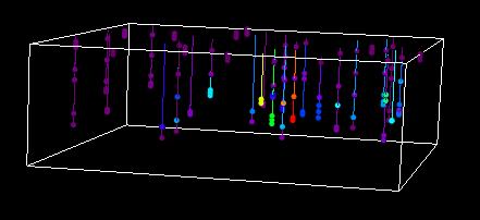
15 3D Visualization True 3d Views: Points, Blocks, and Isosurfaces 15
16 Sample Designs SADA has a number of sample design strategies in Version 4.0. These strategies include initial and secondary designs. Some are based on data alone while others are based on modeling results. With the exception of a couple of exclusively 2d designs all are available in 3d dimensions. Initial Sample Designs Judgmental Simple Random Simple Grid Simple Unaligned Grid Standard Grid Standard Unaligned Grid MARSSIM Design 2d and 3d Hot Spot search designs Secondary Sample Designs Threshold Radial Adaptive Fill High Value (soft, simulated & unsimulated) High Variance (soft, simulated & unsimulated) Extreme Value (soft, simulated & unsimulated) Area of Concern Boundary Design (soft, simulated & unsimulated) Minimize/Maximize Area of Concern LISA Designs (Ripley s K,Moran s I,Geary s C) 16

17 Some Example Initial Designs Judgmental Grids Unaligned Grids Random 3d hotspot search 17


18 Some Example Secondary Designs Threshold Radial High Value Design AOC Boundary Design Adaptive Fill 18
19 SADA Overview: Autodocumentation Provides transparency in the modeling process and facilitates reproducibility of results. SADA automatically analyzes any current result and determines what the ingredients of that result are. These ingredients are presented to the user, who can choose the level of documentation to create. Self-documentation of all parameters, models, and other relevant information. Exposure concentrations Risk models Exposure variables Geospatial parameters Toxicity data Images as bitmaps HTML format, can be exported to popular word processors 19

20 SADA Overview: Autodocumentation Area of concern map Based on HH Risk Utilized inverse distance as geospatial model Block based area of concern framework. 20


21 SADA Overview: Autodocumentation Step Analysis of Model Elements Documenation Output 21

22 Help file 500+ page user guide User group Resources/Support Web page Classes EPA Clue-in classes 22
23 QUESTIONS???? 23
SADA General Information
 SADA General Information Windows--based freeware designed to integrate scientific models with decision and cost analysis frameworks in a seamless, easy to use environment. Visualization/GIS Custom Analysis
Application of SADA for 3D Subsurface Characterization and Suggested Approach for Volumetric Compliance with Decommissioning Dose Criteria
 Application of SADA for 3D Subsurface Characterization and Suggested Approach for Volumetric Compliance with Decommissioning Dose Criteria Robert Stewart, Ph.D. Oak Ridge National Laboratory University
WM2011 Conference, February 27 - March 3, 2011, Phoenix, AZ
 Methodology for Determination of Exposure Point Concentration Using both Systematic and Biased Samples for Radiological Risk and Dose Assessments 11488 Randy Hansen*, Michael Steven Passig*, Mahmudur Rahman**
U.S. EPA Superfund Counts Per Minute (CPM) Electronic Calculator Stuart A. Walker. U.S. Environmental Protection Agency, Washington, DC.
 Electronic Calculator Stuart A. Walker. U.S. Environmental Protection Agency, Washington, DC.") U.S. EPA Superfund Counts Per Minute (CPM) Electronic Calculator 14336 Stuart A. Walker U.S. Environmental Protection Agency, Washington, DC. 20460 ABSTRACT The U.S. Environmental Protection Agency (EPA)
U.S. EPA Superfund Counts Per Minute (CPM) Electronic Calculator 14336 Stuart A. Walker U.S. Environmental Protection Agency, Washington, DC. 20460 ABSTRACT The U.S. Environmental Protection Agency (EPA)
Composite and Discrete Sampling to Attain Risk Based Site. Characterization Objectives - A Case History
 Composite and Discrete Sampling to Attain Risk Based Site Characterization Objectives - A Case History By Mark C. Gemperline, U. S. Bureau of Reclamation, D-8340, PO Box 25007, Denver, CO 80225 Presented
Remedial Investigation of Sediments in NJDEP s Site Remediation and Waste Management Program
 Remedial Investigation of Sediments in NJDEP s Site Remediation and Waste Management Program Nancy Hamill Bureau of Environmental Evaluation and Risk Assessment nancy.hamill@dep.nj.gov 609-633-1353 NJ
Risk Management under the. Chemicals Management Plan
 Risk Management under the Population Exposure Assessment Chemicals Management Plan Approaches and Tools for Health Risk Assessment under CMP Stakeholder Advisory Council meeting Health Canada PAHO Workshop
GIS-Based Sediment Quality Database for the St. Louis River Area of Concern (AOC): Overview Presentations and Demonstration
: Overview Presentations and Demonstration") GIS-Based Sediment Quality Database for the St. Louis River Area of Concern (AOC): Overview Presentations and Demonstration Judy L. Crane 1 and Dawn E. Smorong 2 1 Minnesota Pollution Control Agency, St.
GIS-Based Sediment Quality Database for the St. Louis River Area of Concern (AOC): Overview Presentations and Demonstration Judy L. Crane 1 and Dawn E. Smorong 2 1 Minnesota Pollution Control Agency, St.
Extent of Radiological Contamination in Soil at Four Sites near the Fukushima Daiichi Power Plant, Japan (ArcGIS)
") Extent of Radiological Contamination in Soil at Four Sites near the Fukushima Daiichi Power Plant, Japan (ArcGIS) Contact: Ted Parks, AMEC Foster Wheeler, theodore.parks@amecfw.com, Alex Mikszewski, AMEC
Extent of Radiological Contamination in Soil at Four Sites near the Fukushima Daiichi Power Plant, Japan (ArcGIS) Contact: Ted Parks, AMEC Foster Wheeler, theodore.parks@amecfw.com, Alex Mikszewski, AMEC
Regulatory Guide Exposure Pathways, Equations, and Input Requirements
 Regulatory Guide 1.109 Exposure Pathways, Equations, and Input Requirements Ken Sejkora Entergy Nuclear Northeast Pilgrim Station Presented at the 23rd Annual RETS-REMP Workshop Training Session Westminster,
Bentley Map Advancing GIS for the World s Infrastructure
 Bentley Map Advancing GIS for the World s Infrastructure Presentation Overview Why would you need Bentley Map? What is Bentley Map? Where is Bentley Map Used? Why would you need Bentley Map? Because your
User Guide for the Terrestrial Food Chain and Dose Module FDMT of
 Version 1.1 User Guide for the Terrestrial Food Chain and Dose Module FDMT of RODOS PV6.0 User Guide for the Terrestrial Food Chain and Dose Module FDMT of RODOS PV6.0 Florian Gering, Heinz Müller USER
Mapping Data Facilitator Instructions
 Facilitator Instructions Activity Overview Participants put data from a data table onto a map. Then they use the map to identify trends and hot spots. When to Use It When a group wants to look at data
RITS Fall 2009 Getting the Most Out of Your Conceptual Site Model 1
 of Your Conceptual Site Model 1 of Your Conceptual Site Model 2 of Your Conceptual Site Model 3 of Your Conceptual Site Model 4 of Your Conceptual Site Model 5 The CSM is a comprehensive representation
Section II Assessing Polymers
 26 Clean Production Action GreenScreen v1.4 (January 2018) Section II Assessing Polymers 13. Purpose Section II outlines the procedure to be used to assess and classify hazards of polymers. Follow the
Appendix J. Sensitivity Analysis
 Appendix J Sensitivity Analysis Background Appendix J Acetone VCCEP Sensitivity Analysis for Exposure Modeling A sensitivity analysis was performed for the modeling used in the assessment of.the nail polish
EPRI Report: Review of Geostatistical Approaches to Characterization of Subsurface Contamination
 EPRI Report: Review of Geostatistical Approaches to Characterization of Subsurface Contamination - 17442 Richard McGrath *, Richard Reid*, Phung Tran* *Electric Power Research Institute, 3420 Hillview
USER'S GUIDE: RADIONUCLIDE CARCINOGENICITY
 USER'S GUIDE: RADIONUCLIDE CARCINOGENICITY Introduction EPA classifies all radionuclides as Group A carcinogens. The Radionuclide Table on this website, formerly HEAST Table 4, lists ingestion, inhalation
Case Study: Sediment Contamination by Mercury and DDT and Ecological Risk Assessment for Aquatic Biota, Lake Maggiore, Italy
 Intersol March 19th, 2014 Case Study: Sediment Contamination by Mercury and DDT and Ecological Risk Assessment for Aquatic Biota, Lake Maggiore, Italy CO-AUTHORED BY E Bizzotto and F Colombo PRESENTED
Prof. Dr. Biljana Škrbić, Jelena Živančev
 5 th CEFSER Training Course Analysis of chemical contaminants in food and the environment Faculty of Technology, University of Novi Sad, Novi Sad, Republic of Serbia 7-11 May 2012 Analysis of heavy elements
A robust statistically based approach to estimating the probability of contamination occurring between sampling locations
 A robust statistically based approach to estimating the probability of contamination occurring between sampling locations Peter Beck Principal Environmental Scientist Image placeholder Image placeholder
Linking local multimedia models in a spatially-distributed system
 Linking local multimedia models in a spatially-distributed system I. Miller, S. Knopf & R. Kossik The GoldSim Technology Group, USA Abstract The development of spatially-distributed multimedia models has
IRTC Incremental Sampling Methodology February 2012
 7. MAKING DECISIONS USING ISM DATA 7.1 Introduction This section provides guidance on using data generated from ISM samples to make decisions about a DU. Since the data may inform one or more decisions;
APPENDIX A SENSITIVITY ANALYSIS: HOW DO WE KNOW WHAT S IMPORTANT? A.0 INTRODUCTION
 Appendix A ~ December 31, 2001 APPENDIX A SENSITIVITY ANALYSIS: HOW DO WE KNOW WHAT S IMPORTANT? A.0 INTRODUCTION Sensitivity analysis, as it is applied to risk assessment, is any systematic, common sense
Geospatial Technologies
 An Overview of Prepared by: John McGee Jennifer McKee With support from: NSF DUE-0903270 in partnership with: Geospatial Technician Education Through Virginia s Community Colleges (GTEVCC) What is Geospatial?
One Corps Serving the Army and the Nation. Improving the Quality of Environmental Samples
 Improving the Quality of Environmental Samples Initial Concerns Re Validity of Discrete Sampling, thanks to Sebastian Tindall, Portland 2002 How valid are discrete samples if they are not representative,
QGIS FLO-2D Integration
 EPiC Series in Engineering Volume 3, 2018, Pages 1575 1583 Engineering HIC 2018. 13th International Conference on Hydroinformatics Karen O Brien, BSc. 1, Noemi Gonzalez-Ramirez, Ph. D. 1 and Fernando Nardi,
Optimization of Sediment Sampling at a Tidally Influenced Site (ArcGIS)
") Optimization of Sediment Sampling at a Tidally Influenced Site (ArcGIS) Contacts: Mark Malander, ExxonMobil Environmental Services Company, mark.w.malander@exxonmobil.com, Jeffrey A. Johnson, Newfields, Inc.,
Optimization of Sediment Sampling at a Tidally Influenced Site (ArcGIS) Contacts: Mark Malander, ExxonMobil Environmental Services Company, mark.w.malander@exxonmobil.com, Jeffrey A. Johnson, Newfields, Inc.,
Biocidal Products Committee (BPC)
") Biocidal Products Committee (BPC) Opinion on the application for approval of the active substance: Active chlorine generated from sodium chloride by electrolysis Product type: 5 ECHA/BPC/198/2018 Adopted
Biocidal Products Committee (BPC) Opinion on the application for approval of the active substance: Active chlorine generated from sodium chloride by electrolysis Product type: 5 ECHA/BPC/198/2018 Adopted
Extrapolating New Approaches into a Tiered Approach to Mixtures Risk Assessment
 Extrapolating New into a Tiered Approach to Mixtures Risk Assessment Michael L. Dourson, PhD, DABT, FATS, FSRA Toxicology Excellence for Risk Assessment (TERA) dourson@tera.org Conflict of Interest Statement
OECD QSAR Toolbox v.4.0. Tutorial on how to predict Skin sensitization potential taking into account alert performance
 OECD QSAR Toolbox v.4.0 Tutorial on how to predict Skin sensitization potential taking into account alert performance Outlook Background Objectives Specific Aims Read across and analogue approach The exercise
OECD QSAR Toolbox v.4.1. Tutorial illustrating new options for grouping with metabolism
 OECD QSAR Toolbox v.4.1 Tutorial illustrating new options for grouping with metabolism Outlook Background Objectives Specific Aims The exercise Workflow 2 Background Grouping with metabolism is a procedure
Unit 4. Statistics, Detection Limits and Uncertainty. Experts Teaching from Practical Experience
 Unit 4 Statistics, Detection Limits and Uncertainty Experts Teaching from Practical Experience Unit 4 Topics Statistical Analysis Detection Limits Decision thresholds & detection levels Instrument Detection
Sediment management: a european perspective. Piet den Besten Centre for Water Management Rijkswaterstaat, Netherlands
 Sediment management: a european perspective Piet den Besten Centre for Water Management Rijkswaterstaat, Netherlands Content Background of Dutch-German exchange (DGE plus) What is needed for adequate sediment
Among various open-source GIS programs, QGIS can be the best suitable option which can be used across partners for reasons outlined below.
 Comparison of Geographic Information Systems (GIS) software As of January 2018, WHO has reached an agreement with ESRI (an international supplier of GIS software) for an unlimited use of ArcGIS Desktop
An Investigative Analysis of Soil Quality in the United Kingdom Using the TIBCO Spotfire Software for Inorganic Soil Dashboard
 A P P L I C AT I O N N O T E Analytics Authors: Kathryn Kuhr Robert Packer PerkinElmer, Inc. Shelton, CT An Investigative Analysis of Soil Quality in the United Kingdom Using the TIBCO Spotfire Software
3D MODELLING OF CONTAMINATED SITES MIDWEST AIR AND WASTE MANAGEMENT CONFERENCE FEBRUARY 24, 2016
 3D MODELLING OF CONTAMINATED SITES MIDWEST AIR AND WASTE MANAGEMENT CONFERENCE FEBRUARY 24, 2016 1 3D MODELLING FOR CONTAMINATED SITES KERRY STONESTREET Ramboll Environ will present concepts to consider
Environmental and IH Considerations in Nanomaterial Production and Use
 Environmental and IH Considerations in Nanomaterial Production and Use Elizabeth McMeekin, PE PPG Industries, Inc. emcmeekin@ppg.com Commercialization of NanoMaterials Conference Nov. 12, 2007 NanoMaterials
Great Lakes Online Watershed Interface W. Elliot, Research Engineer USDA Forest Service Rocky Mountain Research Station, Moscow, ID March, 2016
 Great Lakes Online Watershed Interface W. Elliot, Research Engineer USDA Forest Service Rocky Mountain Research Station, Moscow, ID March, 2016 Guidelines for using the Web WEPP Watershed Tool to Support
OECD QSAR Toolbox v.4.1. Tutorial on how to predict Skin sensitization potential taking into account alert performance
 OECD QSAR Toolbox v.4.1 Tutorial on how to predict Skin sensitization potential taking into account alert performance Outlook Background Objectives Specific Aims Read across and analogue approach The exercise
Safety Data Sheets (SDS)
") Safety Data Sheets (SDS) The following content is taken directly from the Government s Occupational Health and Safety Administration (OSHA) website. The following is a description of what a proper SDS
Safety Data Sheets (SDS) The following content is taken directly from the Government s Occupational Health and Safety Administration (OSHA) website. The following is a description of what a proper SDS
PC ARC/INFO and Data Automation Kit GIS Tools for Your PC
 ESRI PC ARC/INFO and Data Automation Kit GIS Tools for Your PC PC ARC/INFO High-quality digitizing and data entry Powerful topology building Cartographic design and query Spatial database query and analysis
The GeoCLIM software for gridding & analyzing precipitation & temperature. Tamuka Magadzire, FEWS NET Regional Scientist for Southern Africa
 The GeoCLIM software for gridding & analyzing precipitation & temperature Tamuka Magadzire, FEWS NET Regional Scientist for Southern Africa Outline What is GeoCLIM GeoCLIM Development Team GeoCLIM: objectives
GIS Test Drive What a Geographic Information System Is and What it Can Do. Alison Davis-Holland
 GIS Test Drive What a Geographic Information System Is and What it Can Do Alison Davis-Holland adavisholland@gmail.com WHO AM I? Geospatial Analyst M.S. in Geographic and Cartographic Sciences Use GIS
AUTOMATED DATA PROCESSING FOR MARITIME AND FLOODS APPLICATIONS
 YOUR HUB FOR GEOSPATIAL APPLICATIONS AUTOMATED DATA PROCESSING FOR MARITIME AND FLOODS APPLICATIONS Angelucci Maria, Daffina Filippo, Grandoni Domenico, Quattrociocchi Dino Automated Data Processing (Smart
GIS Functions and Integration. Tyler Pauley Associate Consultant
 GIS Functions and Integration Tyler Pauley Associate Consultant Contents GIS in AgileAssets products Displaying data within AMS Symbolizing the map display Display on Bing Maps Demo- Displaying a map in
A GIS Tool for Modelling and Visualizing Sustainability Indicators Across Three Regions of Ireland
 International Conference on Whole Life Urban Sustainability and its Assessment M. Horner, C. Hardcastle, A. Price, J. Bebbington (Eds) Glasgow, 2007 A GIS Tool for Modelling and Visualizing Sustainability
Desktop GIS for Geotechnical Engineering
 Desktop GIS for Geotechnical Engineering Satya Priya Deputy General Manager (Software) RMSI, A-7, Sector 16 NOIDA 201 301, UP, INDIA Tel: +91-120-2511102 Fax: +91-120-2510963 Email: Satya.Priya@rmsi.com
Working with FRMAC During an IPX
 DOE/NV/25946--1467 Working with FRMAC During an IPX RaJah Mena FRMAC Senior Scientist Remote Sensing Laboratory Presented to NREP April 23, 2012 This work was done by National Security Technologies, LLC,
Press kit Kartotrak 2014 June 2nd, 2014
 Press kit Kartotrak 2014 June 2nd, 2014 Worldwide leader in Geostatistics, Geovariances enables its clients involved with mapping, resource estimation or risk analysis to benefit from more than 25 years
Application of GIS in hydrological and hydraulic modelling: DLIS and MIKE11-GIS
 HydroGIS 96: Application of Geographic Information Systems in Hydrology and Water Resources Management (Proceedings of the Vienna Conference, April 1996). IAHS Publ. no. 235, 1996. 149 Application of GIS
GIS in Weather and Society
 GIS in Weather and Society Olga Wilhelmi Institute for the Study of Society and Environment National Center for Atmospheric Research WAS*IS November 8, 2005 Boulder, Colorado Presentation Outline GIS basic
Web GIS Based Disaster Portal Project ESRI INDIA
 Web GIS Based Disaster Portal Project ESRI INDIA Contents Requirements Overview Product Technology Used KSNDMC Application Architecture Tool Developed Benefits for the End User Problems faced during implementation
ARCGIS PRO COURSE, APPLIED TO ENVIROMENTAL MANAGEMENT GIS. Course. Training. .com
 ARC PRO COURSE, APPLIED TO ENVIROMENTAL MANAGEMENT TYC Training Course.com TRAINING OVERVIEW This Arc Pro online course will provide a great deal of information about the link between earth s ecosystems
In-situ radiation measurements and GIS visualization / interpretation
 In-situ radiation measurements and GIS visualization / interpretation Román Padilla Alvarez, Iain Darby Nuclear Science and Instrumentation Laboratory Department of Nuclear Sciences and Applications, International
Study of ratio of tritium concentration in plants water to tritium concentration in air moisture for chronic atmospheric release of tritium
 Available online at www.sciencedirect.com Energy Procedia 5 (2011) 2421 2425 IACEED2010 Study of ratio of tritium concentration in plants water to tritium concentration in air moisture for chronic atmospheric
Old Stone Sewer Main Street
 Bangor Landing Bangor, Maine Case Study-Sediment Sediment Investigation Maine Department of Environmental Protection City of Bangor, with RMT, Inc. Site Location and Local Site Features 1 Bangor Landing
Biocidal Products Committee (BPC)
") Biocidal Products Committee (BPC) Opinion on the application for approval of the active substance: Active chlorine generated from sodium chloride by electrolysis Product type: 3 ECHA/BPC/196/2018 Adopted
Biocidal Products Committee (BPC) Opinion on the application for approval of the active substance: Active chlorine generated from sodium chloride by electrolysis Product type: 3 ECHA/BPC/196/2018 Adopted
A national 3D geological model of Denmark: Condensing more than 125 years of geological mapping
 A national 3D geological model of Denmark: Condensing more than 125 years of geological mapping Peter B.E. Sandersen Thomas Vangkilde-Pedersen Geological Survey of Denmark and Greenland Flemming Jørgensen
ZFL, Center of Remote Sensing of Land Surfaces, University of Bonn, Germany. Geographical Institute, University of Bonn, Germany
 Communication of Research Results The IMPETUS Atlas H.-P. Thamm 1, M. Judex 1, O.Schultz 2, S.Krüger 1 & M. Christoph 3 1 ZFL, Center of Remote Sensing of Land Surfaces, University of Bonn, Germany 2 Geographical
Geographic Information Systems(GIS)
") Geographic Information Systems(GIS) Threat Analysis Techniques Overview What is GIS? Functional capabilities of GIS BCM Process and GIS How to leverage GIS in threat/risk analysis Ron Brown, CBCP Managing
Geographic Information Systems(GIS) Threat Analysis Techniques Overview What is GIS? Functional capabilities of GIS BCM Process and GIS How to leverage GIS in threat/risk analysis Ron Brown, CBCP Managing
2016 No. 410 (W. 128) WATER, ENGLAND AND WALES. The Water Supply (Water Quality) (Amendment) Regulations 2016
 WATER, ENGLAND AND WALES. The Water Supply (Water Quality) (Amendment) Regulations 2016") W E L S H S T A T U T O R Y I N S T R U M E N T S 2016 No. 410 (W. 128) WATER, ENGLAND AND WALES The Water Supply (Water Quality) (Amendment) Regulations 2016 Made - - - - 21 March 2016 Laid before Parliament
W E L S H S T A T U T O R Y I N S T R U M E N T S 2016 No. 410 (W. 128) WATER, ENGLAND AND WALES The Water Supply (Water Quality) (Amendment) Regulations 2016 Made - - - - 21 March 2016 Laid before Parliament
JAC Conjunction Assessment
 JAC Conjunction Assessment SSA Operators Workshop Denver, Colorado November 3-5, 2016 François LAPORTE Operational Flight Dynamics CNES Toulouse Francois.Laporte@cnes.fr SUMMARY CA is not an easy task:
KLARA Risk assessment
 KLARA Risk assessment - When working with laboratory chemicals Ulrika Olsson, Chemical Safety Coordinator ulrika.olsson@ki.se Introduction SWEA develop regulations and the aim is to prevent us from illness
Product Stewardship Summary
 Product Stewardship Summary Parachlorobenzotrifluoride General Statement Parachlorobenzotrifluoride (PCBTF) is a volatile organic compound (VOC)-exempt solvent that serves as an alternative to traditional
1. What are OSHA s current PEL time weighted average (TWA) exposure limits for the materials? Acetone Ethyl acetate. Methylene Chloride Toluene
 exposure limits for the materials? Acetone Ethyl acetate. Methylene Chloride Toluene") Names Chem 226/ Fall 2009 Section Dr. Rusay Part II: Turn in one report for your group. Each member of your group is responsible for all of the information in the segments. One of the group will read the
Names Chem 226/ Fall 2009 Section Dr. Rusay Part II: Turn in one report for your group. Each member of your group is responsible for all of the information in the segments. One of the group will read the
What are the five components of a GIS? A typically GIS consists of five elements: - Hardware, Software, Data, People and Procedures (Work Flows)
") LECTURE 1 - INTRODUCTION TO GIS Section I - GIS versus GPS What is a geographic information system (GIS)? GIS can be defined as a computerized application that combines an interactive map with a database
LECTURE 1 - INTRODUCTION TO GIS Section I - GIS versus GPS What is a geographic information system (GIS)? GIS can be defined as a computerized application that combines an interactive map with a database
Chapter 6. Fundamentals of GIS-Based Data Analysis for Decision Support. Table 6.1. Spatial Data Transformations by Geospatial Data Types
 Chapter 6 Fundamentals of GIS-Based Data Analysis for Decision Support FROM: Points Lines Polygons Fields Table 6.1. Spatial Data Transformations by Geospatial Data Types TO: Points Lines Polygons Fields
A Basic Introduction to Geographic Information Systems (GIS) ~~~~~~~~~~
 ~~~~~~~~~~") A Basic Introduction to Geographic Information Systems (GIS) ~~~~~~~~~~ Rev. Ronald J. Wasowski, C.S.C. Associate Professor of Environmental Science University of Portland Portland, Oregon 3 September
A Basic Introduction to Geographic Information Systems (GIS) ~~~~~~~~~~ Rev. Ronald J. Wasowski, C.S.C. Associate Professor of Environmental Science University of Portland Portland, Oregon 3 September
(1) The packing group assignment for routes of administration other than inhalation of vapors shall be in accordance with the following table:
 The packing group assignment for routes of administration other than inhalation of vapors shall be in accordance with the following table:") 173.133 Assignment of packing group and hazard zones for Division 6.1 materials. (a) The packing group of Division 6.1 materials shall be as assigned in column 5 of the 172.101 table. When the 172.101
173.133 Assignment of packing group and hazard zones for Division 6.1 materials. (a) The packing group of Division 6.1 materials shall be as assigned in column 5 of the 172.101 table. When the 172.101
Geostatistical Interpolation: Kriging and the Fukushima Data. Erik Hoel Colligium Ramazzini October 30, 2011
 Geostatistical Interpolation: Kriging and the Fukushima Data Erik Hoel Colligium Ramazzini October 30, 2011 Agenda Basics of geostatistical interpolation Fukushima radiation Database Web site Geoanalytic
Abstract: Contents. Literature review. 2 Methodology.. 2 Applications, results and discussion.. 2 Conclusions 12. Introduction
 Abstract: Landfill is one of the primary methods for municipal solid waste disposal. In order to reduce the environmental damage and to protect the public health and welfare, choosing the site for landfill
INTERNAL RADIATION DOSIMETRY
 INTERNAL RADIATION DOSIMETRY Introduction to Internal Dosimetry Importance of External and Internal Exposures by Radiation Type Charged particle radiation (α, p, β) Generally important only for internal
Representing Data Uncertainties in Overview Maps
 Representing Data Uncertainties in Overview Maps Kumari Gurusamy PhD Candidate, University at Albany (SUNY) GIS Specialist, CIP, CGIAR, Lima, Peru July 2005 ESRI International User Conference 1 Organization
UNIVERSITY OF NAIROBI
 UNIVERSITY OF NAIROBI SITE SUITABILITY ANALYSIS FOR RESIDENTIAL DEVELOPMENTS A case study of Langata Constituency, Nairobi Kenya Presented By Kevin Otiego Supervisor: Mr. Samuel Nthuni Department of Geospatial
EMMA : ECDC Mapping and Multilayer Analysis A GIS enterprise solution to EU agency. Sharing experience and learning from the others
 EMMA : ECDC Mapping and Multilayer Analysis A GIS enterprise solution to EU agency. Sharing experience and learning from the others Lorenzo De Simone, GIS Expert/ EMMA Project Manager 2014 GIS Workshop,
Best Practice Reservoir Characterization for the Alberta Oil Sands
 Best Practice Reservoir Characterization for the Alberta Oil Sands Jason A. McLennan and Clayton V. Deutsch Centre for Computational Geostatistics (CCG) Department of Civil and Environmental Engineering
Outline Brief Overview MapPlace Website Data Delivery & Map Themes Digital Geology
 BRITISH COLUMBIA GEOLOGICAL SURVEY Kirk Hancock Pat Desjardins Nick Massey BRITISH COLUMBIA Ministry of Energy and Mines Ward Kilby acknowledged developer of MapPlace Outline Brief Overview MapPlace Website
Canadian Board of Examiners for Professional Surveyors Core Syllabus Item C 5: GEOSPATIAL INFORMATION SYSTEMS
 Study Guide: Canadian Board of Examiners for Professional Surveyors Core Syllabus Item C 5: GEOSPATIAL INFORMATION SYSTEMS This guide presents some study questions with specific referral to the essential
Development of a GIS Interface for WEPP Model Application to Great Lakes Forested Watersheds
 Development of a GIS Interface for WEPP Model Application to Great Lakes Forested Watersheds J.R. Frankenberger 1, S. Dun 2, D.C. Flanagan 1, J.Q. Wu 2, W.J. Elliot 3 1 USDA-ARS, West Lafayette, IN 2 Washington
OECD Conceptual Framework for Testing and Assessment of Endocrine Disrupters (as revised in 2012)
") OECD Conceptual Framework for Testing and Assessment of Endocrine Disrupters (as revised in 2012) This document presents the revised Conceptual Framework for Testing and Assessment of Endocrine Disrupters,
OECD Conceptual Framework for Testing and Assessment of Endocrine Disrupters (as revised in 2012) This document presents the revised Conceptual Framework for Testing and Assessment of Endocrine Disrupters,
Research and Development of Nanoparticle Characterization Methods
 Research and Development of Nanoparticle Characterization Methods Project Outline This project aims at development of a risk evaluation method based on scientific knowledge for manufactured nanoparticles
PRODUCING PROBABILITY MAPS TO ASSESS RISK OF EXCEEDING CRITICAL THRESHOLD VALUE OF SOIL EC USING GEOSTATISTICAL APPROACH
 PRODUCING PROBABILITY MAPS TO ASSESS RISK OF EXCEEDING CRITICAL THRESHOLD VALUE OF SOIL EC USING GEOSTATISTICAL APPROACH SURESH TRIPATHI Geostatistical Society of India Assumptions and Geostatistical Variogram
INTRODUCTION TO GEOGRAPHIC INFORMATION SYSTEM By Reshma H. Patil
 INTRODUCTION TO GEOGRAPHIC INFORMATION SYSTEM By Reshma H. Patil ABSTRACT:- The geographical information system (GIS) is Computer system for capturing, storing, querying analyzing, and displaying geospatial
1.1 What is Site Fingerprinting?
 Site Fingerprinting Utilizing GIS/GPS Technology 1.1 What is Site Fingerprinting? Site fingerprinting is a planning tool used to design communities where protection of natural resources is the primary
SECTION 3 PRODUCT COMPOSITION The test kit is composed of QuSTICK Strep A Reagent Stick, Reagent A, Reagent B, Positive Control, and Negative Control.
 SECTION 1 PRODUCT AND COMPANY IDENTIFICATION Product Identification: Ref No. 6000, 6000-025, etc. Test kit contains QuSTICK Strep A Reagent Stick, Reagent A, Reagent B, Positive Control, and Negative Control.
Incremental Sampling Methodology
 Incremental Sampling Methodology Advancing the Practice In Massachusetts Jay Clausen: U.S. ACE, ERDC/CRREL Nancy Bettinger: MassDEP/ORS Nancy Bettinger This Presentation Overview of ISM Planning ISM Projects
Introduction to GIS. Dr. M.S. Ganesh Prasad
 Introduction to GIS Dr. M.S. Ganesh Prasad Department of Civil Engineering The National Institute of Engineering, MYSORE ganeshprasad.nie@gmail.com 9449153758 Geographic Information System (GIS) Information
Watershed Application of WEPP and Geospatial Interfaces. Dennis C. Flanagan
 Watershed Application of WEPP and Geospatial Interfaces Dennis C. Flanagan Research Agricultural Engineer USDA-Agricultural Research Service Adjunct Professor Purdue Univ., Dept. of Agric. & Biol. Eng.
Biocidal Products Committee (BPC)
") Biocidal Products Committee (BPC) Opinion on the application for approval of the active substance: Active chlorine generated from sodium chloride by electrolysis Product type: 4 ECHA/BPC/197/2018 Adopted
Biocidal Products Committee (BPC) Opinion on the application for approval of the active substance: Active chlorine generated from sodium chloride by electrolysis Product type: 4 ECHA/BPC/197/2018 Adopted
A Help Guide for Using gssurgo to Find Potential Wetland Soil Landscapes
 A Help Guide for Using gssurgo to Find Potential Wetland Soil Landscapes Wetland Mapping Consortium Webinar September 17, 2014 Dr. John M. Galbraith Crop & Soil Environmental Sciences Virginia Tech Wetland
GENASIS: On-Line Data Browser for Environmental Monitoring and Associated Information Systems
 GENASIS: On-Line Data Browser for Environmental Monitoring and Associated Information Systems Jiří Jarkovský 1, Ladislav Dušek 1, Miroslav Kubásek 1, Richard Hůlek 1,2, Jakub Gregor 1,2, Jiří Hřebíček
A GIS based Decision Support Tool for the Management of Industrial Risk
 A GIS based Decision Support Tool for the Management of Industrial Risk S.A Karkanis and G.S.Bonanos Institute of Nuclear Technology - Radiation Protection, National Center for Scientific Research DEMOKRITOS,
Quantifying exposure from radionuclides for environmental receptors
 Quantifying exposure from radionuclides for environmental receptors Justin Brown IUR Consensus Symposium 2015, Miami Beach, 17th November 2015 Talk Contents Will focus on environmental exposure estimation
Transactions on Information and Communications Technologies vol 18, 1998 WIT Press, ISSN
 STREAM, spatial tools for river basins, environment and analysis of management options Menno Schepel Resource Analysis, Zuiderstraat 110, 2611 SJDelft, the Netherlands; e-mail: menno.schepel@resource.nl
This document is a preview generated by EVS
 INTERNATIONAL STANDARD ISO 13196 First edition 2013-03-01 Soil quality Screening soils for selected elements by energydispersive X-ray fluorescence spectrometry using a handheld or portable instrument
National Capitol Region HAZUS User Group Call. June 20, :00 AM EST
 National Capitol Region HAZUS User Group Call June 20, 2013 10:00 AM EST NCR HUG Call Details Conference Call Details: 1. Dial-in: 1-267-507-0240 2. Conference code: 697620 Join the Meeting through Adobe
Choropleth Visualization of EPA Superfund Sites
 Choropleth Visualization of EPA Superfund Sites Connie Lin and Matthew Windsor Drexel University Abstract Current mapping techiques used by TOXMAP Environmental Health e-maps regarding Superfund sites
Toward an automatic real-time mapping system for radiation hazards
 Toward an automatic real-time mapping system for radiation hazards Paul H. Hiemstra 1, Edzer J. Pebesma 2, Chris J.W. Twenhöfel 3, Gerard B.M. Heuvelink 4 1 Faculty of Geosciences / University of Utrecht
ECOTOX: A Foundation for Extrapolation
 ECOTOX: A Foundation for Extrapolation Christine Russom U.S. EPA/ORD/NHEERL/MED Presented at the McKim Conference on the Use of QSARs June 27-29, 29, 26 What is ECOTOX? ECOTOX is a comprehensive web-based