UNIVERSITY OF NAIROBI
|
|
|
- Gillian Green
- 5 years ago
- Views:
Transcription
1 UNIVERSITY OF NAIROBI SITE SUITABILITY ANALYSIS FOR RESIDENTIAL DEVELOPMENTS A case study of Langata Constituency, Nairobi Kenya Presented By Kevin Otiego Supervisor: Mr. Samuel Nthuni Department of Geospatial Engineering and Space Technology April 30 th 2015 otiegokevin@gmail.com
2 TABLE OF CONTENTS Introduction Problem Statement Objectives Methodology Results and Analysis Conclusion and Recommendations
3 INTRODUCTION Identification of potential sites for residential developments is one of the critical issues of planning. Selecting suitable sites for residential development is a complex process which may result to conflicting objectives. These complexities necessitate the simultaneous use of several decision support tools such as GIS and MCE technique using AHP. Selecting suitable sites for residential development is a complex process which may result to conflicting objectives. Spatial Multicriteria Evaluation Techniques can be used to identify suitable sites for residential developments.
4 PROBLEM STATEMENT Identification of suitable sites for residential developments is fundamental for urban development to overcome undesirable urban growth The main problem is to establish locations that can support residential developments depending on a number of factors that have conventionally been identified. This will be solved by considering the affecting factors as criteria and carrying out multi criteria analysis using GIS tools in order to arrive at a result showing suitable sites for residential developments.
5 Main Objective OBJECTIVES To Identify potential sites suitable for residential developments in Langata constituency using spatial multi criteria techniques. Specific Objectives To Develop a Matlab program to compute criterion weights based on the principles of Analytical Hierarchy Process To Produce a suitability map for each evaluation criterion To Carry out spatial multicriteria analysis resulting in the determination of suitable sites for residential developments
6 METHODOLOGY

7 ANALYSIS CRITERIA

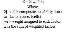
8 OVERLAY FORMULAE IMPLEMENTED: WEIGHTING
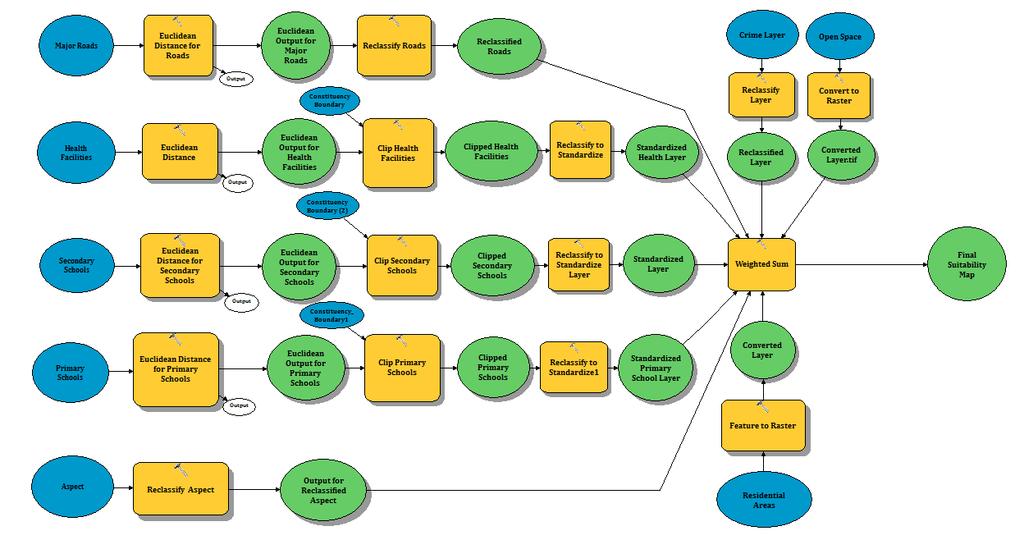
9 SUITABILITY MODEL

10 AREA OF STUDY Constituency Number Attribute Profile 277 Population 176,314 Area County Member of Parliament Number of County Assembly sq.km Nairobi Joshua Olum 5 Source: KNBS

11 CRITERION MAP FOR LAND SUITABILITY

12 PROXIMITY TO PRIMARY SCHOOLS SUITABILITY MAP

13 PROXIMITY TO SECONDARY SCHOOLS SUITABILITY MAP

14 PROXIMITY TO HEALTH FACILITIES SUITABILITY MAP
15 ASPECT SUITABILITY MAP
16 ROAD PROXIMITY SUITABILITY MAP

17 SECURITY SUITABILITY MAP
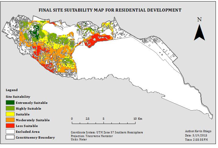
18 FINAL SUITABILITY MAP

19 EXTREMELY SUITABLE AREAS

20 LESS SUITABLE AREAS

21 CONCLUSION The framework developed in this study successfully identified areas in Langata Constituency that were suitable for residential development based on the selected criteria. This indicates that Langata Constituency has the ability to fulfill future demands for residential needs.
22 RECOMMENDATIONS Further analysis should be carried out to evaluate the economic costs, benefits and risks associated with developing the identified sites. The Getis-Ord G-Statistic is recommended to help shed more insight and perhaps provide a conclusive reason why 45.8% (27.02km²) of the area considered suitable for analysis, was not found suitable for residential development. Web-based mapping application should be developed showing suitable sites for residential development. This will have greater impact on the public through interactive, web-based maps by improving information dissemination. Another recommendation, which is of personal interest, would be to implement the developed AHP computation program into GIS learning module as an example of spatial problem solving using GIS and in particular the Multi Criteria Decision Making.
23 Thank You
Site Suitability Analysis for Urban Development: A Review
 Site Suitability Analysis for Urban Development: A Review Santanu Kumar Misra Associate Professor (Dept. of CSE) Sikkim Manipal Institute of Technology Majitar, Sikkim misra_santanu@rediffmail.com Shrijana
KING FAHD UNIVERSITY OF PETROLEUM & MINERALS
 KING FAHD UNIVERSITY OF PETROLEUM & MINERALS Department of City & Regional Planning Introduction To GIS (CRP 514) Identifying & Planning Public School Facility In California Using GIS Presented to Dr.
Applications of GIS in Electrical Power System. Dr. Baqer AL-Ramadan Abdulrahman Al-Sakkaf
 Applications of GIS in Electrical Power System Dr. Baqer AL-Ramadan Abdulrahman Al-Sakkaf OUTLINES: Objective Importance of GIS GIS data development Application of GIS Findings Conclusions and Recommendations
transportation research in policy making for addressing mobility problems, infrastructure and functionality issues in urban areas. This study explored
 ABSTRACT: Demand supply system are the three core clusters of transportation research in policy making for addressing mobility problems, infrastructure and functionality issues in urban areas. This study
Case study: Nairobi City County CBD and its Environs. Presenter: Peter Patrick Kioko. Supervisor: Mr. B.M. Okumu
 Case study: Nairobi City County CBD and its Environs Presenter: Peter Patrick Kioko Supervisor: Mr. B.M. Okumu OUTLINE Introduction Problem Statement Objectives Area of study Application of GIS Methodology
A soft computing logic method for agricultural land suitability evaluation
 A soft computing logic method for agricultural land suitability evaluation B. Montgomery 1, S. Dragićević 1* and J. Dujmović 2 1 Geography Department, Simon Fraser University, 8888 University Drive, Burnaby,
Application of Geographic Information Systems for Government School Sites Selection
 Rs. 3000,00 Application of Geographic Information Systems for Government School Sites Selection by K. D. Nethsiri Jayaweera M.Sc. Library - USJP 1111111111111111 210975 2014 210873 Application of Geographic
LOCATION OF PREHOSPITAL CARE BASIS THROUGH COMBINED FUZZY AHP AND GIS METHOD
 ISAHP Article: Mu, Saaty/A Style Guide for Paper Proposals To Be Submitted to the LOCATION OF PREHOSPITAL CARE BASIS THROUGH COMBINED FUZZY AHP AND GIS METHOD Marco Tiznado Departamento de Ingeniería Industrial,
COUNTY SPATIAL DATA INFRASTRUCTURE PRESENTATION: BY: GEOFREY CHERUIYOT NAIROBI CITY COUNTY
 . COUNTY SPATIAL DATA INFRASTRUCTURE PRESENTATION: BY: GEOFREY CHERUIYOT NAIROBI CITY COUNTY FRAMEWORK FOR AN INTEGRATED SPATIAL DATA INFRASTRUCTURE County GIS GIS : A computer based information system
FINAL YEAR PRESENTATION USE OF GEOSPATIAL TECHNOLOGY IN SUITABILITY ANALYSIS FOR NEW SITES OF MULTI-LEVEL CAR PARKING AREAS
 FINAL YEAR PRESENTATION USE OF GEOSPATIAL TECHNOLOGY IN SUITABILITY ANALYSIS FOR NEW SITES OF MULTI-LEVEL CAR PARKING AREAS PRESENTED BY JASPHER OTIENO SUPERVISOR DR.NYIKA Contents Overview Area of study
Landfill Sites Identification Using GIS and Multi-Criteria Method: A Case Study of Intermediate City of Punjab, Pakistan
 Journal of Geographic Information System, 2016, 8, 40-49 Published Online February 2016 in SciRes. http://www.scirp.org/journal/jgis http://dx.doi.org/10.4236/jgis.2016.81004 Landfill Sites Identification
USING GIS AND AHP TECHNIQUE FOR LAND-USE SUITABILITY ANALYSIS
 USING GIS AND AHP TECHNIQUE FOR LAND-USE SUITABILITY ANALYSIS Tran Trong Duc Department of Geomatics Polytechnic University of Hochiminh city, Vietnam E-mail: ttduc@hcmut.edu.vn ABSTRACT Nowadays, analysis
GIS application in locating suitable sites for solid waste landfills
 GIS application in locating suitable sites for solid waste landfills Jayawickrama, N. T. and Weerasinghe, V. P. A Abstract In Sri Lanka solid wastes are haphazardly dumped in unsuitable locations frequently.
INVESTIGATION OF AN AHP BASED MULTI CRITERIA WEIGHTING SCHEME FOR GIS ROUTING OF CROSS COUNTRY PIPELINE PROJECTS
 24th International Symposium on on Automation & Robotics in in Construction (ISARC 2007) Construction Automation Group, I.I.T. Madras INVESTIGATION OF AN AHP BASED MULTI CRITERIA WEIGHTING SCHEME FOR GIS
Contents. Interactive Mapping as a Decision Support Tool. Map use: From communication to visualization. The role of maps in GIS
 Contents Interactive Mapping as a Decision Support Tool Claus Rinner Assistant Professor Department of Geography University of Toronto otru gis workshop rinner(a)geog.utoronto.ca 1 The role of maps in
Relief Camp Tool Using GIS
 Relief Camp Tool Using GIS MAYANK SINGH SAKLA 1, JANKI ADHVARYU 2 1 M.TECH GEOMATICS STUDENT, CEPT UNIVERSITY 2 M.TECH GEOMATICS STUDENT, CEPT UNIVERSITY K L CAMPUS UNIVERSITY AREA NAVARANG PURA AHMEDABAD
Abstract: Contents. Literature review. 2 Methodology.. 2 Applications, results and discussion.. 2 Conclusions 12. Introduction
 Abstract: Landfill is one of the primary methods for municipal solid waste disposal. In order to reduce the environmental damage and to protect the public health and welfare, choosing the site for landfill
GIS Geographical Information Systems. GIS Management
 GIS Geographical Information Systems GIS Management Difficulties on establishing a GIS Funding GIS Determining Project Standards Data Gathering Map Development Recruiting GIS Professionals Educating Staff
SA Geospatial Analysis Platform (GAP) Methodology*, collaborators & data sources
 Methodology*, collaborators & data sources") SA Geospatial Analysis Platform (GAP) Methodology*, collaborators & data sources Mesoframe CSIR, dti, the Presidency & GTZ Demarcation of South Africa into a grid of 50 Km 2 mesozones, nested within important
SA Geospatial Analysis Platform (GAP) Methodology*, collaborators & data sources Mesoframe CSIR, dti, the Presidency & GTZ Demarcation of South Africa into a grid of 50 Km 2 mesozones, nested within important
Basics of GIS. by Basudeb Bhatta. Computer Aided Design Centre Department of Computer Science and Engineering Jadavpur University
 Basics of GIS by Basudeb Bhatta Computer Aided Design Centre Department of Computer Science and Engineering Jadavpur University e-governance Training Programme Conducted by National Institute of Electronics
MANAGING TRANSPORTATION & LAND USE INTERACTIONS (PL-58)
") MANAGING TRANSPORTATION & LAND USE INTERACTIONS (PL-58) COURSE OUTLINE DAY ONE 1:30 2:00 p.m. MODULE 1: History and Context Understand history and foundation for transportation and land use planning today
MANAGING TRANSPORTATION & LAND USE INTERACTIONS (PL-58) COURSE OUTLINE DAY ONE 1:30 2:00 p.m. MODULE 1: History and Context Understand history and foundation for transportation and land use planning today
King Fahd University of Petroleum & Minerals College of Engineering Sciences Civil Engineering Department. Geographical Information Systems(GIS)
") King Fahd University of Petroleum & Minerals College of Engineering Sciences Civil Engineering Department Geographical Information Systems(GIS) Term Project Titled Delineating Potential Area for Locating
King Fahd University of Petroleum & Minerals College of Engineering Sciences Civil Engineering Department Geographical Information Systems(GIS) Term Project Titled Delineating Potential Area for Locating
Fuzzy model in urban planning
 Fuzzy model in urban planning JASNA PLEHO, ZIKRIJA AVDAGIC Faculty of Electrical Engineering University Sarajevo Zmaja od Bosne bb, Sarajevo BOSNIA AND HERZEGOVINA Abstract: - This paper presents application
Calculating Land Values by Using Advanced Statistical Approaches in Pendik
 Presented at the FIG Congress 2018, May 6-11, 2018 in Istanbul, Turkey Calculating Land Values by Using Advanced Statistical Approaches in Pendik Prof. Dr. Arif Cagdas AYDINOGLU Ress. Asst. Rabia BOVKIR
Economic and Social Urban Indicators: A Spatial Decision Support System for Chicago Area Transportation Planning
 Economic and Social Urban Indicators: A Spatial Decision Support System for Chicago Area Transportation Planning Piyushimita Thakuriah (Vonu), P.S. Sriraj, Paul Metaxatos, Inshu Minocha & Tanushri Swarup
Neighborhood Locations and Amenities
 University of Maryland School of Architecture, Planning and Preservation Fall, 2014 Neighborhood Locations and Amenities Authors: Cole Greene Jacob Johnson Maha Tariq Under the Supervision of: Dr. Chao
Land Use of the Geographical Information System (GIS) and Mathematical Models in Planning Urban Parks & Green Spaces
 and Mathematical Models in Planning Urban Parks & Green Spaces") Land Use of the Geographical Information System (GIS) and Mathematical Models in Planning Urban Key words: SUMMARY TS 37 Spatial Development Infrastructure Linkages with Urban Planning and Infrastructure
Land Use of the Geographical Information System (GIS) and Mathematical Models in Planning Urban Key words: SUMMARY TS 37 Spatial Development Infrastructure Linkages with Urban Planning and Infrastructure
Planning for Sea Level Rise in the Matanzas Basin
 Planning for Sea Level Rise in the Matanzas Basin Appendix E: Matanzas Future Development Scenarios June, 2015 Prepared by: Dr. Paul Zwick University of Florida Department of Urban and Regional Planning
GIS and territorial planning
 icccbe 2010 Nottingham University Press Proceedings of the International Conference on Computing in Civil and Building Engineering W Tizani (Editor) GIS and territorial planning S. Sheina & V. Shumeev
Application of GIS and Remote Sensing Technologies in Solid Waste Management: A Case Study of Nyahururu Municipality
 Application of GIS and Remote Sensing Technologies in Solid Waste Management: A Case Study of Nyahururu Municipality Duncan Maina Kimwatu 1, Martin Gitonga Ndiritu 2 1, 2 Dedan Kimathi University of Technology,
Generic Success Criteria
 Generic Success Criteria Significance I can identify a short term and long term impact that a development/event/issue has/had locally/globally. I can discuss (verbally, graphically, etc.) how a development/event/issue
Simulating urban growth in South Asia: A SLEUTH application
 Simulating urban growth in South Asia: A SLEUTH application Gargi Chaudhuri* 1 1 1725 State St., 2022 Cowley Hall, Department of Geography and Earth Science, University of Wisconsin-La Crosse *Email: gchaudhuri@uwlax.edu
Determination of Suitable Landfill Site Using Geospatial Techniques: A Case study of Vasai-Virar City
 Determination of Suitable Landfill Site Using Geospatial Techniques: A Case study of Vasai-Virar City Ms. Priyanka S. Deshmukh 1, Prof. Upendra R. Saharkar 2 1 P.G Student, Department of Civil Engineering,
Framework Contract for Copernicus Service in Support to EU External Action Geospatial Production
 Framework Contract for Copernicus Service in Support to EU External Action Geospatial Production ANNEX E to the Tender Specifications SEA Portfolio Invitation to tender SATCEN-OP-01/17 Page 1 of 11 1.
Correspondence should be addressed to Santosh Kumar,
 Cloud Publications International Journal of Advanced Remote Sensing and GIS 2014, Volume 3, Issue 1, pp. 516-524, Article ID Tech-253 ISSN 2320-0243 Case Study Open Access Site Suitability Analysis for
R. Cons. Eng. Simon Mwangi REGISTERED CONSULTING ENGINEER
 R. Cons. Eng. Simon Mwangi REGISTERED CONSULTING ENGINEER eng.simon.mwangi@gmail.com Vision 2030 Statement is a national long-term development blue-print to create a globally competitive and prosperous
Dr.Sinisa Vukicevic Dr. Robert Summers
 Dr.Sinisa Vukicevic Dr. Robert Summers "Planning" means the scientific, aesthetic, and orderly disposition of land, resources, facilities and services with a view to securing the physical, economic and
DATA DISAGGREGATION BY GEOGRAPHIC
 PROGRAM CYCLE ADS 201 Additional Help DATA DISAGGREGATION BY GEOGRAPHIC LOCATION Introduction This document provides supplemental guidance to ADS 201.3.5.7.G Indicator Disaggregation, and discusses concepts
8 th Meeting of IAEG-SDGs 5 8 November 2018, Stockholm, Sweden. Meetings. Report
 Meetings 8 th Meeting of IAEG-SDGs Between April 2018 and November 2018, the Working Group on Geospatial Information of the IAEG- SDGs held two online meetings; presented a report to the United Nations
UN-GGIM: Europe ExCom 1 June 2016 Francfort Work Group A «Core Data» Status and Progress François Chirié, France
 UN-GGIM: Europe ExCom 1 June 2016 Francfort Work Group A «Core Data» Status and Progress François Chirié, France Plan The Core Data Scope Deliverable 7-8 June 2016 WGA workshop to investigate work plans
GIS Analysis and Spatial Modelling for Optimal Oil Pipeline Route Location: A Case Study of Proposed Isiolo Nakuru Pipeline Route
 GIS Analysis and Spatial Modelling for Optimal Oil Pipeline Route Location: A Case Study of Proposed Isiolo Nakuru Pipeline Route Macharia Peter M 1, Charles N. Mundia 2 1 Topsurv Geosystems Limited, P.O
Demand and Supply Evaluation of Urban Facilities Needed for Management of Tehran after an Earthquake: a DEA approach
 13 th International Conference on Data Envelopment Analysis Demand and Supply Evaluation of Urban Facilities Needed for Management of Tehran after an Earthquake: a DEA approach M. Taleai, A.H. Rahnama
Urban Spatial Scenario Design Modelling (USSDM) in Dar es Salaam: Background Information
 in Dar es Salaam: Background Information") Urban Spatial Scenario Design Modelling (USSDM) in Dar es Salaam: Background Information Modelling urban settlement dynamics in Dar es Salaam Revision: 2 (July 2013) Prepared by: Katja Buchta TUM team
Urban Spatial Scenario Design Modelling (USSDM) in Dar es Salaam: Background Information Modelling urban settlement dynamics in Dar es Salaam Revision: 2 (July 2013) Prepared by: Katja Buchta TUM team
Promoting synergy between airports and cities to achieve sustainable development
 Promoting synergy between airports and cities to achieve sustainable development Content 1. Airports / Aviation 2. Urbanization 3. Shared Threads & Opportunities 4. Synergistic Development for Sustainability
I Background. Under the Cotton Tree: Situs Addressing System in Africa. Table of contents
 Cairo, April 2005 Under the Cotton Tree: Situs Addressing System in Africa Table of contents 1. Background 2. Current situation of addressing system in Africa 3. Benefits of a functional addressing system
Land Use Methods & Metrics Development Outcome
 Quarterly Progress Meeting November 15, 2018 Land Use Methods & Metrics Development Outcome Peter Claggett, USGS LUWG Coordinator Through the Chesapeake Bay Watershed Agreement, the Chesapeake Bay Program
CHALLENGES WITH THE FUNDAMENTAL GEOSPATIAL DATA IN AFRICA
 CHALLENGES WITH THE FUNDAMENTAL GEOSPATIAL DATA IN AFRICA Dr Derek Clarke Chair: UN-GGIM: Africa WG on Fundamental Geospatial Data and Standards derek.clarke.dr@gmail.com International Workshop on Fundamental
High Speed / Commuter Rail Suitability Analysis For Central And Southern Arizona
 High Speed / Commuter Rail Suitability Analysis For Central And Southern Arizona Item Type Reports (Electronic) Authors Deveney, Matthew R. Publisher The University of Arizona. Rights Copyright is held
International Journal of Computing and Business Research (IJCBR) ISSN (Online) : APPLICATION OF GIS IN HEALTHCARE MANAGEMENT
 ISSN (Online) : APPLICATION OF GIS IN HEALTHCARE MANAGEMENT") International Journal of Computing and Business Research (IJCBR) ISSN (Online) : 2229-6166 Volume 3 Issue 2 May 2012 APPLICATION OF GIS IN HEALTHCARE MANAGEMENT Dr. Ram Shukla, Faculty (Operations Area),
International Journal of Computing and Business Research (IJCBR) ISSN (Online) : 2229-6166 Volume 3 Issue 2 May 2012 APPLICATION OF GIS IN HEALTHCARE MANAGEMENT Dr. Ram Shukla, Faculty (Operations Area),
1. INTRODUCTION ACEPS
 Application of Remote Sensing and GIS techniques for exploring Construction Material from inaccessible terrains; case study in Eastern Province of Sri Lanka H.M.R. Premasiri, H.C.D.P. Colombage, D.Palamakumbure,
INTEGRATION OF GIS AND MULTICRITORIAL HIERARCHICAL ANALYSIS FOR AID IN URBAN PLANNING: CASE STUDY OF KHEMISSET PROVINCE, MOROCCO
 Geography Papers 2017, 63 DOI: http://dx.doi.org/10.6018/geografia/2017/280211 ISSN: 1989-4627 INTEGRATION OF GIS AND MULTICRITORIAL HIERARCHICAL ANALYSIS FOR AID IN URBAN PLANNING: CASE STUDY OF KHEMISSET
Montgomery County Community College GEO 210 Introduction to Geographic Information Systems (GIS) 3-2-2
 3-2-2") Montgomery County Community College GEO 210 Introduction to Geographic Information Systems (GIS) 3-2-2 COURSE DESCRIPTION: This introduction to Geographic Information Systems is structured to develop skills
Montgomery County Community College GEO 210 Introduction to Geographic Information Systems (GIS) 3-2-2 COURSE DESCRIPTION: This introduction to Geographic Information Systems is structured to develop skills
Spatial Analysis and Modeling of Urban Land Use Changes in Lusaka, Zambia: A Case Study of a Rapidly Urbanizing Sub- Saharan African City
 Spatial Analysis and Modeling of Urban Land Use Changes in Lusaka, Zambia: A Case Study of a Rapidly Urbanizing Sub- Saharan African City January 2018 Matamyo SIMWANDA Spatial Analysis and Modeling of
GIS-Based Multi Criteria Evaluation for Thermal Power Plant Site Selection in Kahnuj County, SE Iran
 Print ISSN: 2322-2093; Online ISSN: 2423-6691 DOI: 10.7508/ceij.2017.01.011 Technical Note GIS-Based Multi Criteria Evaluation for Thermal Power Plant Site Selection in Kahnuj County, SE Iran Siefi, S.
Web-GIS Application using Multi-Attribute Utility Theory to Classify Accident-Prone Roads
 Web-GIS Application using Multi-Attribute Utility Theory to Classify Accident-Prone Roads Anik Vega Vitianingsih, Dwi Cahyono, Achmad Choiron Department of Informatics Engineering, Universitas Dr.Soetomo
Introduction and Project Overview
 Greater New Orleans Regional Land Use Modeling GIS Techniques in a P olitical C ontext Louisiana Remote Sensing and GIS Workshop Wednesday, April 24, 2013 Working Towards a Shared Regional Vision Introduction
SPACE-TIME ACCESSIBILITY MEASURES FOR EVALUATING MOBILITY-RELATED SOCIAL EXCLUSION OF THE ELDERLY
 SPACE-TIME ACCESSIBILITY MEASURES FOR EVALUATING MOBILITY-RELATED SOCIAL EXCLUSION OF THE ELDERLY Izumiyama, Hiroshi Institute of Environmental Studies, The University of Tokyo, Tokyo, Japan Email: izumiyama@ut.t.u-tokyo.ac.jp
Research on Comprehensive Decision Model Based on Analytic Hierarchy Process and Entropy Method Yi-Peng LI 1,a, Xin ZHANG 2,b,*
 2017 3rd Annual International Conference on Modern Education and Social Science (MESS 2017) ISBN: 978-1-60595-450-9 Research on Comprehensive Decision Model Based on Analytic Hierarchy Process and Entropy
Integration for Informed Decision Making
 Geospatial and Statistics Policy Intervention: Integration for Informed Decision Making Greg Scott Global Geospatial Information Management United Nations Statistics Division Department of Economic and
INFORMATION SYSTEM OF FORECASTING INFRASTRUCTURE DEVELOPMENT IN TOURISM
 Management of Natural Disaster Mitigation Systems and Practical Examples UDC: 007:338.8 DOI: 10.2298/IJGI1303279G INFORMATION SYSTEM OF FORECASTING INFRASTRUCTURE DEVELOPMENT IN TOURISM Bogdan Gats*, Petro
APPLICATION OF GIS IN COMPULSORY LAND ACQUISITION PROCESS. CASE STUDY: PARTS OF KAJIADO COUNTY SECTION OF THE STANDARD GAUGE RAILWAY
 APPLICATION OF GIS IN COMPULSORY LAND ACQUISITION PROCESS. CASE STUDY: PARTS OF KAJIADO COUNTY SECTION OF THE STANDARD GAUGE RAILWAY MUSYOKA SOLOMON NTHAMA F19/1456/2010 PROJECT SUPERVISOR : J.N. MWENDA
Investigation into the authorities efforts to limit flood and landslide hazards. Presentation at the seminar on Auditing climate change, Copenhagen
 Investigation into the authorities efforts to limit flood and landslide hazards Presentation at the seminar on Auditing climate change, Copenhagen 24.03.2010 324 000 km2 + Arctic islands 4,8 millions inhabitants,
D14. Volcanic Viewshafts and Height Sensitive Areas Overlay
 D14. Volcanic Viewshafts and Height Sensitive Areas Overlay D14.1. Overlay description The purpose of the Volcanic Viewshafts and Height Sensitive Areas Overlay is to appropriately protect significant
Chapter 6. Fundamentals of GIS-Based Data Analysis for Decision Support. Table 6.1. Spatial Data Transformations by Geospatial Data Types
 Chapter 6 Fundamentals of GIS-Based Data Analysis for Decision Support FROM: Points Lines Polygons Fields Table 6.1. Spatial Data Transformations by Geospatial Data Types TO: Points Lines Polygons Fields
City of Lockport Historic Resources Survey - Section METHODOLOGY
 2.0 METHODOLOGY Clinton Brown Company PN 07-008 2-1 April 2011 2.0 METHODOLOGY This methodology statement is prepared as part of the project tasks. It outlines the research sources identified, field strategies,
GIS as a tool in flood management
 GIS for the United Nations and the International Community Conference Panel: GIS and Capacity - How Territorial Planning Benefits from Geospatial Information 3-5 April 2012 Geneva, Switzerland GIS as a
Population Research Center (PRC) Oregon Population Forecast Program
 Oregon Population Forecast Program") Population Research Center (PRC) Oregon Population Forecast Program 2013 Oregon League of Cities Conference Risa S. Proehl Jason R. Jurjevich, Ph.D. Population Research Center (PRC) Population Research
Population Research Center (PRC) Oregon Population Forecast Program 2013 Oregon League of Cities Conference Risa S. Proehl Jason R. Jurjevich, Ph.D. Population Research Center (PRC) Population Research
GIS AND GEOSPATIAL INFORMATION MANAGEMENT FOR URBAN PLANNING AND LAND MANAGEMENT IN SAUDI ARABIA
 GIS AND GEOSPATIAL INFORMATION MANAGEMENT FOR URBAN PLANNING AND LAND MANAGEMENT IN SAUDI ARABIA Manal Al-Hajji GIS Consultant Oman Geospatial Forum Oman April 10-11, 2017 CONTENTS 1. Future Saudi Cities
Module - 3 GIS MAPPING, MIS AND GIS UNDER RAY
 Module - 3 1 GIS MAPPING, MIS AND GIS MIS INTEGRATION UNDER RAY Role of GIS & MIS under RAY Under the scheme, two step implementation strategy has been adopted i.e. preparation of SFCPoAs on whole city
A Preliminary Model of Community-based Integrated Information System for Urban Spatial Development
 A Preliminary Model of Community-based Integrated Information System for Urban Spatial Development Bauni HAMID 1, Devin DEFRIZA 2 1 2 CAITAD (Center of Applied Information Technology in Planning and Design),
Assessing the Regional Vulnerability of Large Scale Mining in Ghana: An Application of Multi Criteria Analysis
 Assessing the Regional Vulnerability of Large Scale Mining in Ghana: An Application of Multi Criteria Analysis Mukesh Subedee, GISDE 14 Arun Poojary, ES&P 13 Clark University April 29, 2013 Ghana: A case
A GIS-based multicriteria model for the evaluation of territorial accessibility
 Sustainable Development and Planning II, Vol. 2 795 A GIS-based multicriteria model for the evaluation of territorial accessibility J. F. G. Mendes, D. S. Rodrigues & R. A. R. Ramos Department of Civil
SDI Development in Georgia. Mari Khardziani Head of International Relations Unit National Agency of Public Registry
 SDI Development in Georgia Mari Khardziani Head of International Relations Unit National Agency of Public Registry Kehl, Germany September 5, 2017 2 National Agency of Public Registry Legal Entity of Public
SITE SUITABILITY ANALYSIS FOR URBAN DEVELOPMENT USING GIS BASE MULTICRITERIA EVALUATION TECHNIQUE IN NAVI MUMBAI, MAHARASHTRA, INDIA
 International Journal of Advanced Research in Engineering and Technology (IJARET) Volume 10, Issue 1, January- February 2019, pp. 55-69, Article ID: IJARET_10_01_006 Available online at http://www.iaeme.com/ijaret/issues.asp?jtype=ijaret&vtype=10&itype=01
Applications of GIS in Electrical Power System
 Applications of GIS in Electrical Power System Abdulrahman M. AL-Sakkaf 201102310 CRP 514 May 2013 Dr. Baqer M. AL-Ramadan Abstract GIS has been widely used in various areas and disciplines. This paper
Ivy S. G. Akuoko NRS Concepts of GIS and Remote Sensing in Environmental Science December 14, 2017 Overview & Annotated Bibliography
 Ivy S. G. Akuoko NRS 509 - Concepts of GIS and Remote Sensing in Environmental Science December 14, 2017 Overview & Annotated Bibliography MANAGING SOLID WASTE WITH THE SUPPORT OF GIS AND REMOTE SENSING
Multi-Objective evolutionary algorithm for modeling of site suitability for health-care facilities
 RESEARCH ARTICLE Multi-Objective evolutionary algorithm for modeling of site suitability for health-care facilities Sara Beheshtifar 1, Abbas Alimohammadi 2 1. PhD Student of GIS engineering, Faculty of
2 nd Semester. Core Courses. C 2.1 City and Metropolitan Planning. Module 1: Urban Structure and Growth Implications
 2 nd Semester Core Courses C 2.1 City and Metropolitan Planning Module 1: Urban Structure and Growth Implications Growth of cities; cities as engine of growth; urban sprawl; land value, economic attributes
Integration of GIS and Multicriteria Evaluation for School Site Selection A Case Study of Belgut Constituency
 Integration of GIS and Multicriteria Evaluation for School Site Selection A Case Study of Belgut Constituency Philip Kiprono Talam* and Moses Murimi Ngigi 1 Abstract- Site selection is a complex problem
Census Geography, Geographic Standards, and Geographic Information
 Census Geography, Geographic Standards, and Geographic Information Michael Ratcliffe Geography Division US Census Bureau New Mexico State Data Center Data Users Conference November 19, 2015 Today s Presentation
Optimized positioning for accommodation centers in GIS using AHP techniques; a case study: Hamedan city
 Journal of Tourism & Hospitality Research Islamic Azad University, Garmsar Branch Vol. 2, No. 2, Autumn 2012, Pp.19-29 Optimized positioning for accommodation in GIS using AHP techniques; a case study:
OREGON POPULATION FORECAST PROGRAM
 OREGON POPULATION FORECAST PROGRAM PROGRAM OVERVIEW BACKGROUND Beginning in 1973 with the passage of Senate Bill (SB) 100, Oregon s growth management system has relied on population forecasts as the primary
Grade 6 Social Studies
 Grade 6 Social Studies Social Studies Grade(s) 6th Course Overview This course focuses on the five Wisconsin Model Academic standards for Social Studies: Geography, History, Political Science and Citizenship,
Utilization and Provision of Geographical Name Information on the Basic Map of Japan*
 UNITED NATIONS WORKING PAPER GROUP OF EXPERTS NO. 1/9 ON GEOGRAPHICAL NAMES Twenty-eight session 28 April 2 May 2014 Item 9 of the Provisional Agenda Activities relating to the Working Group on Toponymic
Identifying Audit, Evidence Methodology and Audit Design Matrix (ADM)
") 11 Identifying Audit, Evidence Methodology and Audit Design Matrix (ADM) 27/10/2012 Exercise XXX 2 LEARNING OBJECTIVES At the end of this session participants will be able to: 1. Identify types and sources
11 Identifying Audit, Evidence Methodology and Audit Design Matrix (ADM) 27/10/2012 Exercise XXX 2 LEARNING OBJECTIVES At the end of this session participants will be able to: 1. Identify types and sources
RURAL SETTLEMENT PATTERNS AND ACCESS TO DEVELOPMENT LAND: DEVELOPING THE EVIDENCE BASE
 School of Planning, Architecture and Civil Engineering RURAL SETTLEMENT PATTERNS AND ACCESS TO DEVELOPMENT LAND: DEVELOPING THE EVIDENCE BASE Prepared for Friends of the Earth Northern Ireland 18 th April
Transport Planning in Large Scale Housing Developments. David Knight
 Transport Planning in Large Scale Housing Developments David Knight Large Scale Housing Developments No longer creating great urban spaces in the UK (Hall 2014) Transport Planning Transport planning processes
SOLID WASTE MANAGEMENT IN GREATER SHILLONG PLANNING AREA (GSPA) USING SPATIAL MULTI-CRITERIA DECISION ANALYSIS FOR SITE SUITABILITY ASSESSMENT
 USING SPATIAL MULTI-CRITERIA DECISION ANALYSIS FOR SITE SUITABILITY ASSESSMENT") SOLID WASTE MANAGEMENT IN GREATER SHILLONG PLANNING AREA (GSPA) USING SPATIAL MULTI-CRITERIA DECISION ANALYSIS FOR SITE SUITABILITY ASSESSMENT B. S. Mipun a, R. Hazarika b, M. Mondal c, Sovanlal Mukhopadhyay
SOLID WASTE MANAGEMENT IN GREATER SHILLONG PLANNING AREA (GSPA) USING SPATIAL MULTI-CRITERIA DECISION ANALYSIS FOR SITE SUITABILITY ASSESSMENT B. S. Mipun a, R. Hazarika b, M. Mondal c, Sovanlal Mukhopadhyay
Environmental Management Information System (EMIS)
") United Nations Human Settlements Programme (UN-HABITAT) United Nations Environment Programme (UNEP) Environmental Management Information System (EMIS) a tool for Environmental Planning and Management (EPM)
United Nations Human Settlements Programme (UN-HABITAT) United Nations Environment Programme (UNEP) Environmental Management Information System (EMIS) a tool for Environmental Planning and Management (EPM)
Analysis of Regional Fundamental Datasets Questionnaire
 Permanent Committee on GIS Infrastructure for Asia and the Pacific Working Group 2 Regional Fundamental Data Summary Report on Analysis of Regional Fundamental Datasets Questionnaire ABBAS RAJABIFARD and
DECISION MAKING IN AGRICULTURE BASED ON LAND SUITABILITY SPATIAL DATA ANALYSIS APPROACH
 DECISION MAKING IN AGRICULTURE BASED ON LAND SUITABILITY SPATIAL DATA ANALYSIS APPROACH 1 M. PARIMALA, 2 DAPHNE LOPEZ 1 Asst Prof., School of Information Technology & Engineeirng, VIT University 2 Prof.,
Exploring Reciprocal Relationships of Land-Uses in a Historical Mixed-Use Quarter of Istanbul
 Exploring Reciprocal Relationships of Land-Uses in a Historical Mixed-Use Quarter of Istanbul Measuring mixed-use patterns of Cihangir Ahu Sokmenoglu 1, N. Onur Sonmez 2 Istanbul Technical University,
Edexcel Geography Advanced Paper 2
 Edexcel Geography Advanced Paper 2 SECTION B: SHAPING PLACES Assessment objectives AO1 Demonstrate knowledge and understanding of places, environments, concepts, processes, interactions and change, at
Tools to Assess Local Health Needs. Richard Leadbeater, Esri NACo 2011 Healthy Counties Forum December 1, 2011
 Tools to Assess Local Health Needs Richard Leadbeater, Esri NACo 2011 Healthy Counties Forum December 1, 2011 Richard Leadbeater currently holds the position of Industry Solutions Manager with Esri. He
SADA General Information
 SADA General Information Windows--based freeware designed to integrate scientific models with decision and cost analysis frameworks in a seamless, easy to use environment. Visualization/GIS Custom Analysis
CES Seminar 2016: Geospatial information services based on official statistics Key issues from the session II papers
 Norbert Rainer 64 th plenary session of the Conference of European Statisticians 28 April 2016, Paris CES Seminar 2016: Geospatial information services based on official statistics Key issues from the
Geographical knowledge and understanding scope and sequence: Foundation to Year 10
 Geographical knowledge and understanding scope and sequence: Foundation to Year 10 Foundation Year 1 Year 2 Year 3 Year 4 Year 5 Year 6 Year level focus People live in places Places have distinctive features
JUSPS-B Vol. 29(9), (2017). Periodicity-Monthly. Section B
, (2017). Periodicity-Monthly. Section B") (Print) JUSPS-B Vol. 29(9), 207-211 (2017). Periodicity-Monthly Section B (Online) JOURNAL OF ULTRA SCIENTIST OF PHYSICAL SCIENCES An International Open Free Access Peer Reviewed Research Journal of Physical
(Print) JUSPS-B Vol. 29(9), 207-211 (2017). Periodicity-Monthly Section B (Online) JOURNAL OF ULTRA SCIENTIST OF PHYSICAL SCIENCES An International Open Free Access Peer Reviewed Research Journal of Physical
CHAPTER 3 METHODOLOGY
 32 CHAPTER 3 METHODOLOGY 3.1 GENERAL In 1910, the seismological society of America identified the three groups of earthquake problems, the associated ground motions and the effect on structures. Indeed
A COMPUTER-AIDED SYSTEM FOR SITE SELECTION OF MAJOR CAPITAL INVESTMENTS
 1 st ASCAAD International Conference, e-design in Architecture Dhahran, Saudi Arabia. December 2004 3 A COMPUTER-AIDED SYSTEM FOR SITE SELECTION OF MAJOR CAPITAL INVESTMENTS NEIL N. ELDIN 1 AND K. A. ELDRANDALY