Creating a Definitive Place Name Layer (Gazetteer) for Scotland. Bruce M. Gittings Panos Terzis The University of Edinburgh
|
|
|
- Shanna Short
- 5 years ago
- Views:
Transcription

1 Creating a Definitive Place Name Layer (Gazetteer) for Scotland Bruce M. Gittings Panos Terzis The University of Edinburgh
2 Some Definitions Short-form gazetteers: often used in conjunction with computer mapping and GIS systems, may simply contain a list of place-names together with their locations in latitude and longitude or other spatial referencing systems (eg. British National Grid Reference). Short-form gazetteers appear as a place-name index in the rear of major published atlases. Address Gazetteers: geo-referenced address lists, often used by local authorities for purposes such as local taxation Long-form (or Descriptive) gazetteers: may include lengthy textual descriptions of the places they contain, including explanation of industries, government, geography, together with historical perspectives, maps and / or photographs. Thematic gazetteers: list places or geographical features by theme; for example fishing ports, nuclear power stations or historic buildings. Their common element is that the geographical location is an important attribute of the features listed.

3 Scottish Tradition Scotland has a rich set of geographical names drawn from English, Scots, Gaelic, Norse, Anglo-Saxon, German, French Names, descriptions and illustrations formed part of Scottish maps back into the 16th century A fine tradition of descriptive gazetteer publishing flowered in the 19th century Scotland produced gazetteers for around the world, or certainly those countries administered by Britain
4 Drivers for a Contemporary Gazetteer INSPIRE: Annex 1 requires a Geographical Names Layer But also: Increased desire to cross-link datasets, often datasets which don't have (x,y) coordinates Need to avoid inconsistencies Link with historical information Show-case our country National Interest - across government, NGOs, private sector and the general public Many other countries are way ahead

5 Where Place Names are Useful Tourist Accommodation Visit Scotland Historic Buildings Historic Scotland Restaurants Yellow Pages Local History Monuments RCAHMS Banking Services Tourist Attractions Visit Scotland Populations Statistics GROS Property Values Schools RoS Local Authority Pollution Scottish Water Lost Hillwalker Mountain Rescue RBS, HBOS etc Nature Reserves SNH Injured Wild Animal RSPCA Emergency Services NHS, Fire Brigade, Police
6 So surely this is not a problem? One would think the UK has a list of all its place names!?! The USA has the US Board on Geographic Names Resolution IV of the UN Conference of Geographic Names (1967) directed that standardisation of place names be achieved by establishing national place name authorities We have the Permanent Committee on Geographical Names for British Official Use: "Principal function is to advise British government departments and agencies on policies and procedures for the proper writing, in official publications, of geographical names for places and features outside the United Kingdom, excluding those of the Antarctic" Key players are the British National Mapping Agency Ordnance Survey (de facto portrayer of place-names) and Local Authorities (legally responsible for settlement names)
7 Existing Gazetteers/Place Name Layers Ordnance Survey (OS) Harper-Collins Bartholomew XYZ / People's Map Royal Commission on the Ancient and Historic Monuments of Scotland (RCAHMS) The Gazetteer for Scotland One Scotland Gazetteer Ainmean-Àite na h-alba (AÀA) Scottish Place-Name Database Google ScotlandsPlaces Navteq (Nokia) TeleAtlas (TomTom) Open Street Maps

8 Name Inconsistencies Crown Copyright, Ordnance Survey Collins Bartholomew
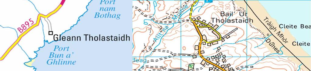
9 Too many Place Names Bhaile a' Mhanaich Baile a' Mhanaich Balivanish Baile Mhanaich Balivanich Ballivanich Bailebhainich Bhaile a Mhanaich Balmanich Bhaile a Mhanich Bhail a' Mhanaich Bailivanich Balinanish


10 Its not just a Gaelic-English Problem

11 A Problem for Mariners? The Northern Lighthouse Board refers to its lighthouses using 'old' names no longer used on the Ordnance Survey map: Ushenish vs Usinish or Uisinis Holburn Head vs. Holborn Head
12 Ordnance Survey 1:50,000 Gazetteer Place name layer regarded as an easy problem to solve Assumption was existing Ordnance Survey 1:50,000 gazetteer would serve this need But we have already seen it has omissions and shortcomings Fundamentally it is a map index, not a gazetteer
13 OS 1:50,000 Gazetteer Shortcomings Poor spatial referencing: names (not necessarily features) only located to a 1km grid-square A lack of alternative names, including Gaelic names. There are only 25 alternative names within the 86,095 names recorded in Scotland Poor feature-typing: there are only ten classes; two are 'other' and 'all other features', which together account for 56,060 of the 86,095 features; another of the ten feature-types is "Roman Antiquity" which has only 13 occurrences in Scotland Un-named features eg. "monument" are included Uneven coverage of the country; few names are recorded within towns and cities, because there is no space for these on the Landranger map
14 OS 1:50,000 Gazetteer Shortcomings There are notable errors; for example, seven cities are recorded in Scotland, there should be only six Occasional spelling / typographical errors Repeated names eg. river names which appear more than once on the map There is a one-to-one relationship between features and feature-types, for example cannot be a farm and an antiquity A one-to-one relationship between a name and an administrative geography. For example, hills located on local authority (Council Area) boundaries are randomly allocated to one or other local authority, rather than being linked to both

 The format of the OS gazetteer is far from the INSPIRE requirements (INSPIRE")
15 OS 1:50,000 Gazetteer Shortcomings Many (significant) named places not recorded in OS gazetteer No historical geographical units Historical / archaic toponyms not retained More sophisticated relationships certainly absent (eg. 'part of') The format of the OS gazetteer is far from the INSPIRE requirements (INSPIRE Data Specification on Geographical Names)
16 The Solution Merge the OS 1:50K gazetteer with another gazetteer which makes up for its shortcomings The Gazetteer for Scotland is a descriptive gazetteer which has been built up over 15 years consistent coverage none of the data model issues of the OS 1:50K BUT not nearly as many entries as OS The OS gazetteer is now freely available under OS Open Data; Gazetteer for Scotland also available One makes up for inadequacies of the other Cross checking improves the quality of both Sizeable manual editing operation (c. 140 person days)
17 What to include? INSPIRE definition: "Names of areas, regions, localities, cities, suburbs, towns or settlements, or any geographical or topographical feature of public or historical interest." Might add "architectural, archaeological, environmental, geological, topographical or cultural significance" Summarised as "public, professional or historical interest"? Scale and Significance: The Wallace Monument vs. the Scott Monument vs. all the other monuments on Princes Street? What is significant in a village is not significant in a city Include abandoned settlements; of interest in terms of cultural history Ontological Issues: eg. Settlement vs hamlet vs village vs town vs city vs inhabited place vs suburb vs community vs municipality vs neighbourhood vs urban district


18 Editing Tool A customised editing tool was constructed to optimise the editing process Allows modification of spatial location and classification of feature Linked to imagery, historical and contemporary maps (eg. OS Open Data)
19 Results Spatial locations now better than 100m, minimum of 5% better than 20m But point locations generally not a problem probably no bad thing for most polygonal features (eg. urban districts) is a problem for linear features Ten point classification enrichened to 143; rather more than required by INSPIRE (While note has been taken of Linda Hill's ADL work, the classification is tailored to Scotland eg. lochs, the scattered nature of crofting settlements) Many features reclassified eg. the number of farm names has grown from 1287 to (although still only a partial list)
20 Services Implementing a name-layer as a WMS / WFS is trivial but does not get the most from the data OGC Gazetteer Service (WFS-G) goes further More extensive name services are not well developed They should be able to link data by: translating a name into coordinate (geocoding, geoparsing) a coordinate into a name finding or suggesting best matches for name variants, mis-spellings, archaic forms providing middleware services (eg. improving geographical search) Collect vernacular names?
21 Key Messages Scotland had no standardised list of place names This gives rise to a series of problems / missed opportunities An INSPIRE-compliant names layer has been created by bringing together two existing datasets Much improvement and error checking undertaken Work completed in six months Funded by the Scottish Government as part of the Geographic Information Strategy for Scotland This dataset will be made available on the most relaxed licensing terms possible to encourage its use The form of the names-server and future maintenance of the data are still under discussion
Creating a Definitive Place Name Gazetteer for Scotland. Bruce M. Gittings
 Creating a Definitive Place Name Gazetteer for Scotland Bruce M. Gittings School of GeoSciences, University of Edinburgh, Edinburgh, UK bruce@ed.ac.uk Place-names represent a fundamental geographical identifier,
Current Status of the Standardization of Geographical Names in Cambodia
 1 Current Status of the Standardization of Geographical Names in Cambodia His Excellency Ith Sotha, Under Secretary of States, MLMUPC Mr Chharom Chin, Deputy Director, Geography Department, MLMUPC Mr Narith
Developing a Spatial Data Infrastructure for Cultural Heritage
 Developing a Spatial Data Infrastructure for Cultural Heritage Peter M c Keague (RCAHMS) Anthony Corns and Robert Shaw (Discovery Programme) Developing a Spatial Data Infrastructure for Cultural Heritage
D.N.D. Hettiarachchi (Hetti) Survey Department, Sri Lanka.
 Survey Department, Sri Lanka.") ADMINISTRATION OF GEOGRAPHICAL NAMES IN SRI LANKA D.N.D. Hettiarachchi (Hetti) Survey Department, Sri Lanka. hettiarachchidnd@gmail.com Country: Sri Lanka What is the official language(s)? Sinhala and
ADMINISTRATION OF GEOGRAPHICAL NAMES IN SRI LANKA D.N.D. Hettiarachchi (Hetti) Survey Department, Sri Lanka. hettiarachchidnd@gmail.com Country: Sri Lanka What is the official language(s)? Sinhala and
Our Lady Immaculate Catholic Primary School History and Geography Curriculum Map Would the Bog Baby survive in Liverpool?
 Year 1 and 2 - *Year 1 and 2 work on a two year cycle due to mixed classes Autumn 1 National Curriculum link: Human and physical geography - identify seasonal and daily weather patterns in the United Kingdom
Preparing the GEOGRAPHY for the 2011 Population Census of South Africa
 Preparing the GEOGRAPHY for the 2011 Population Census of South Africa Sharthi Laldaparsad Statistics South Africa; E-mail: sharthil@statssa.gov.za Abstract: Statistics South Africa (Stats SA) s Geography
Report of the United Kingdom Division
 UNITED NATIONS GROUP OF EXPERTS WORKING PAPER ON GEOGRAPHICAL NAMES NO. 41/4 Twenty-ninth session Bangkok, Thailand, 25 29 April 2016 Item 4 of the Provisional Agenda Report of the Divisions Report of
A Data Repository for Named Places and Their Standardised Names Integrated With the Production of National Map Series
 A Data Repository for Named Places and Their Standardised Names Integrated With the Production of National Map Series Teemu Leskinen National Land Survey of Finland Abstract. The Geographic Names Register
19.2 Geographic Names Register General The Geographic Names Register of the National Land Survey is the authoritative geographic names data
 Section 7 Technical issues web services Chapter 19 A Data Repository for Named Places and their Standardised Names Integrated with the Production of National Map Series Teemu Leskinen (National Land Survey
Geography. Programmes of study for Key Stages 1-3
 Geography Programmes of study for Key Stages 1-3 February 2013 Contents Purpose of study 3 Aims 3 Attainment targets 3 Subject content 4 Key Stage 1 4 Key Stage 2 5 Key Stage 3 6 2 Purpose of study A high-quality
The Geography Curriculum at Coston Primary
 The Geography Curriculum at Coston Primary Years Year 1 Year 2 Summer We are learning about where food is farmed and in The physical features of farms. The human features of farms. The characteristics
Geography Long Term Plan 2018
 Geography Long Term Plan 2018 Geography Co-ordinator: Megan Frost A high-quality geography education should inspire in pupils a curiosity and fascination about the world and its people that will remain
NATIONAL CURRICULUM GEOGRAPHY PLANNING OVERVIEW
 GEOGRAPHY AUTUMN TERM SPRING TERM SUMMER TERM Year 1 Hunting and Hiding Me and My Wonderful World Beside The Sea identify seasonal and daily weather patterns in the United Kingdom and the location of hot
Tuition, Medical and Behaviour Support Service
 Tuition, Medical and Behaviour Support Service Curriculum Policy - Primary Geography Reviewed: October 2018 Next Review: October 2019 Responsibility: Andrea Snow AIMS AND PRINCIPLES The national curriculum
HAREWOOD JUNIOR SCHOOL KEY SKILLS
 HAREWOOD JUNIOR SCHOOL KEY SKILLS Geography Purpose of study A high-quality geography education should inspire in pupils a curiosity and fascination about the world and its people that will remain with
Turkey National Report
 UNITED NATIONS Working Paper GROUP OF EXPERTS ON No. 26 GEOGRAPHICAL NAMES Twenty-third Session Vienna, 28 March 4 April 2006 Item 5 of the Provisional Agenda: Reports of the division Turkey National Report
Higher National Unit specification. General information for centres. Heritage Studies: Scotland. Unit code: F3TL 35
 Higher National Unit specification General information for centres Unit title: Heritage Studies: Scotland Unit code: F3TL 35 Unit purpose: The Unit is designed to provide candidates with an overview of
BLACK PEAR TRUST SUBJECT PLAN - GEOGRAPHY
 Purpose of Study A high-quality geography education should inspire in pupils a curiosity and fascination about the world and its people that will remain with them for the rest of their lives. Teaching
Geography Long Term Plan
 Geography Long Term Plan Year Group Children should be taught about: The topic this will be based on: Essential Learning Objectives: (Taken from Chris Quigley) Year 1 Name and locate the world s seven
Compact guides GISCO. Geographic information system of the Commission
 Compact guides GISCO Geographic information system of the Commission What is GISCO? GISCO, the Geographic Information System of the COmmission, is a permanent service of Eurostat that fulfils the requirements
ST AMBROSE CATHOLIC PRIMARY SCHOOL Geography Policy
 ST AMBROSE CATHOLIC PRIMARY SCHOOL Geography Policy 2017-2018 Our school policy is developed in accordance with the National Curriculum for Geography and Foundation Stage Curriculum for Understanding of
St Joseph s R.C. Primary School. Policy for Geography
 St Joseph s R.C. Primary School Policy for Geography 2016-2017 This policy is written with consideration to our school commitment to the Rights of the Child and our achievement of becoming a Rights Respecting
GEOGRAPHY POLICY STATEMENT. The study of geography helps our pupils to make sense of the world around them.
 GEOGRAPHY POLICY STATEMENT We believe that the study of geography is concerned with people, place, space and the environment and explores the relationships between the earth and its peoples. The study
Abbotswood Junior School National Curriculum 2014
 Geography Purpose A high-quality geography education should inspire in pupils a curiosity and fascination about the world and its people that will remain with them for the rest of their lives. Teaching
Year 1 name and locate the four countries and capital cities of the United Kingdom and its surrounding seas
 Long Term Objective Organisation for Geography Please note that only statutory requirements should be included in this document; any supplementary guidance and information should be retained by Subject
Cranford Park CE Primary School. Subject Overview for Geography. Autumn 1 Autumn 2 Spring 1 Spring 2 Summer 1 Summer 2 Title of unit.
 Autumn 1 Autumn 2 Spring 1 Spring 2 Summer 1 Summer 2 Main Objectives /Skills Main Objectives /Skills Main Objectives /Skills Main Objectives /Skills Main Objectives /Skills Main Objectives /Skills Foundation
HOLY CROSS CATHOLIC PRIMARY SCHOOL
 HOLY CROSS CATHOLIC PRIMARY SCHOOL Geography Policy Date Implemented Jan 17 Review Date Jan 22 Mission Statement Holy Cross Primary School is a Catholic School. We seek to provide a broad, balanced Christian
Content Area: Social Studies Standard: 1. History Prepared Graduates: Develop an understanding of how people view, construct, and interpret history
 Standard: 1. History Develop an understanding of how people view, construct, and interpret history 1. Organize and sequence events to understand the concepts of chronology and cause and effect in the history
MEADOWS PRIMARY SCHOOL and NURSERY GEOGRAPHY POLICY
 MEADOWS PRIMARY SCHOOL and NURSERY GEOGRAPHY POLICY Purpose of study The teaching of Geography at Meadows is done by following the 2014 National Curriculum. The planning and teaching of the subject aims
St John s Catholic Primary School. Geography Policy. Mission Statement
 St John s Catholic Primary School Geography Policy Mission Statement We at St John s strive for excellence in education by providing a safe, secure and caring family environment where individuals are valued
Range of Opportunities
 Geograhy Curriculum Cropwell Bishop Primary School Range of Opportunities Year 1 Year 2 Year 3 Year 4 Year 5 Year 6 All Key Stage 1 Key Stage 2 Investigate the countries and capitals of the United Kingdom.
Walworth Primary School
 Walworth Primary School Date: April 2016 Revision Due: April 2017 Ref: L.Smith Geography Policy 1 Geography Policy Introduction A high quality geography education should inspire in pupils a curiosity and
Gazetteer Services: A Scottish Perspective
 Gazetteer Services: A Scottish Perspective Bruce M. Gittings Edinburgh Earth Observatory University of Edinburgh bruce@geo.ed.ac.uk Summary Scottish Context Importance of Gazetteers Definitive Address
History and Geography. History: Geography:
 History and Geography History: The aim of history teaching at Dartford Primary Academy is to stimulate the children s interest and facilitate their understanding about the life of people who lived in the
Geography Policy. Introduction
 Geography Policy Introduction Geography at St. Aloysius Federation School teaches an understanding of places and environments and aims to inspire a curiosity and fascination about the world and its people.
Mutah university faculty of Social Sciences The Study plan of the department of Geography 2006/2007
 Mutah university faculty of Social Sciences The Study plan of the department of Geography 2006/2007 Requirements university compulsory 22 Credit hours Course No Credit hours Prerequisite Requirements Faculty
Geography Long Term Plan. Autumn Spring Summer
 Geography Long Term Plan Autumn Spring Summer Year 1 Working Scientifically covered throughout the year Location Geography of UK Name, locate and identify characteristics of the four countries and capital
Technical Specifications. Form of the standard
 Used by popular acceptance Voluntary Implementation Mandatory Legally enforced Technical Specifications Conventions Guidelines Form of the standard Restrictive Information System Structures Contents Values
Roadmap to interoperability of geoinformation
 Roadmap to interoperability of geoinformation and services in Europe Paul Smits, Alessandro Annoni European Commission Joint Research Centre Institute for Environment and Sustainability paul.smits@jrc.it
Complete Geography Overview: Year 1 to Year 6
 Option 1 Complete Geography Overview: Year 1 to Year 6 Autumn Term Spring Term Summer Term Year 1 Where do I live? Around the World The Four Seasons Year 2 At the Farm Let s go on Safari My World and Me
30 Broad Street, Wokingham, Berkshire
 30 Broad Street, Wokingham, Berkshire An Archaeological Watching Brief for Psilogic Ltd by Steve Ford Thames Valley Archaeological Services Ltd Site Code 30BSW01/81 October 2001 Summary Site name: 30 Broad
2011 Built-up Areas - Methodology and Guidance
 2011 Built-up Areas - Methodology and Guidance June 2013 Version: 2013 v1 Office for National Statistics 2013 Contents 1. Introduction... 3 2. Methodology... 3 2.1 Identifying built-up areas for the 2011
INDIANA ACADEMIC STANDARDS FOR SOCIAL STUDIES, WORLD GEOGRAPHY. PAGE(S) WHERE TAUGHT (If submission is not a book, cite appropriate location(s))
 WHERE TAUGHT (If submission is not a book, cite appropriate location(s))") Prentice Hall: The Cultural Landscape, An Introduction to Human Geography 2002 Indiana Academic Standards for Social Studies, World Geography (Grades 9-12) STANDARD 1: THE WORLD IN SPATIAL TERMS Students
Prentice Hall: The Cultural Landscape, An Introduction to Human Geography 2002 Indiana Academic Standards for Social Studies, World Geography (Grades 9-12) STANDARD 1: THE WORLD IN SPATIAL TERMS Students
World Geography. WG.1.1 Explain Earth s grid system and be able to locate places using degrees of latitude and longitude.
 Standard 1: The World in Spatial Terms Students will use maps, globes, atlases, and grid-referenced technologies, such as remote sensing, Geographic Information Systems (GIS), and Global Positioning Systems
Land Board, NW Services and SDI Tambet Tiits, FRICS
 Land Board, NW Services and SDI Tambet Tiits, FRICS 07.09.2016 200th anniversary of the Struve Geodetic Arc Friedrich Georg Wilhelm Struve and Carl Friedrich Tenner Struve Geodetic Arc The Struve Geodetic
Geography Policy 2014
 Geography Policy 2014 DEFINITION Geography education should inspire in pupils a curiosity and fascination about the world and its people that will remain with them for the rest of their lives. Teaching
Subject: Geography Scheme of Work: B1 to B6 Mastery tiles. Term: Autumn/Spring/Summer
 Subject: Geography Scheme of Work: B1 to B6 Mastery tiles Term: Autumn/Spring/Summer Topic / Unit(s) Overview / Context Introduction to geography. An introduction to geography including basic map skills
Geography Skills Progression. Eden Park Primary School Academy
 Geography Skills Progression Eden Park Primary School Academy In order to ensure broad and balanced coverage, we follow these principles: Within each phase, geography is a driver for at least 3 Learning
STAG LANE JUNIOR SCHOOL GEOGRAPHY POLICY
 Status-Recommended Prepared by: Megha Visavadia Date written January 2017 Shared with staff: Spring 2017 STAG LANE JUNIOR SCHOOL GEOGRAPHY POLICY Shared with governors: Spring 2018 Date for review: July
INSPIRing effort. Peter Parslow Ordnance Survey December Various European approaches to managing an SDI
 INSPIRing effort Peter Parslow Ordnance Survey December 2015 Various European approaches to managing an SDI WHAT IS INSPIRE? A European Union Directive A community effort: http://inspire.ec.europa.eu/
Autumn Term Spring Term Summer Term Year Group
 History and Geography Long Term Plan 16/17 Autumn Term Spring Term Summer Term Year Group Fire Food and Farming Journeys Giraffes, 1 and 2 Great fire of London significant event. Hot weather/seasonal/equat
St. James C of E Primary School
 St. James C of E Primary School Geography Policy St. James C of E Primary School Geography Policy Written by: Lisa Harford Written: April 2016 Reviewed: April 2018 1. Introduction Geography is concerned
Geography Progression
 Geography Progression This document aims to track expectations for History within George Grenville Academy. What the National Curriculum says: KS1: Locational Knowledge: Name and locate the world s 7 continents
Geography Mile Post 1
 Mile Post 1 Use world maps, atlases and globes to identify the UK and its countries, as well as the countries, continents and oceans studied at this key stage Key Skills IPC learning Goals 1.11 Be able
GEOVEKST A Norwegian Program for Cost Sharing in Production, Updating and Administration of Geographic Data
 GEOVEKST A Norwegian Program for Cost Sharing in Production, Updating and Administration of Dr. Anne Kirsten S. HØSTMARK, Norway Key words: Mapping in large scale, formal co-operation, cost sharing, standarised
SITMUN: Cooperating to Build Local SDIs in the Barcelona Region
 SITMUN: Cooperating to Build Local SDIs in the Barcelona Region Diputació de Barcelona Territory and Sustainability Area Territorial Information Systems Department INSPIRE CONFERENCE Barcelona, September
TRANSFORMATION THROUGH CLC WITH THE CONTINUOUS RESEARCH TECHNIQUES - GIS (OPEN CODE) AND RS (GEO-WEB SERVICES)
 AND RS (GEO-WEB SERVICES)") DOI 10.2478/pesd-2018-0036 PESD, VOL. 12, no. 2, 2018 TRANSFORMATION THROUGH CLC WITH THE CONTINUOUS RESEARCH TECHNIQUES - GIS (OPEN CODE) AND RS (GEO-WEB SERVICES) Florim Isufi 1, Shpejtim Bulliqi 2,
DOI 10.2478/pesd-2018-0036 PESD, VOL. 12, no. 2, 2018 TRANSFORMATION THROUGH CLC WITH THE CONTINUOUS RESEARCH TECHNIQUES - GIS (OPEN CODE) AND RS (GEO-WEB SERVICES) Florim Isufi 1, Shpejtim Bulliqi 2,
Witchampton CofE First School Geography Curriculum Map
 2016-2017 Autumn People and : 30-50 Show interest in the lives of people who are familiar to them. Shows interest in different occupations. Remembers and talks significant events in their own experience.
Country Report of United Kingdom *
 HIGH LEVEL FORUM ON GLOBAL CONFERENCE ROOM PAPER GEOSPATIAL MANAGEMENT INFORMATION NO. 12 First Forum Seoul, Republic of Korea, 24-26 October 2011 Country Report of United Kingdom * * Submitted by: Dr
name and locate the world s seven continents and five oceans
 Subject: Geography Activities National Curriculum Objectives One Progression of Skills Name the 7 continents and 5 oceans 3D Jigsaw task to locate continents and seas name and locate the world s seven
Wednesday 8 June 2016 Afternoon
 Oxford Cambridge and RSA H Wednesday 8 June 2016 Afternoon GCSE GEOGRAPHY A A732/02 Geographical Skills (Higher Tier) *4410185572* Candidates answer on the Question Paper. OCR supplied materials: An Insert
Scotland s People in Time and Space
 Scotland s People in Time and Space Geography and the work of the General Register Office Scotland Duncan Macniven Registrar General Scotland 1 The work of GROS Registering births, deaths, marriages etc
Nursery. Reception. Year 1
 Nursery Geography Overview Autumn Spring Summer Notices detailed features of objects in their environment. Comments and asks questions about aspects of their familiar world such as the place where they
A new type of RICEPOTS
 A new type of RICEPOTS Alan Parkinson Geography teaching resource College Crown Copyright and Database Right 2014. Ordnance Survey (Digimap Licence) This is one of a series of teaching resources for use
Contents Curriculum Map p Curriculum Map (draft). p3 Geography - Key Skills and Concepts.. p4. - Subject Content..
. p3 Geography - Key Skills and Concepts.. p4. - Subject Content..") Contents 2017-18 Curriculum Map p2 2018-19 Curriculum Map (draft). p3 Geography - Key Skills and Concepts.. p4 - Subject Content.. p5 History - Key Skills and Concepts. P7 - Subject Content.. p8 Curriculum
Contents 2017-18 Curriculum Map p2 2018-19 Curriculum Map (draft). p3 Geography - Key Skills and Concepts.. p4 - Subject Content.. p5 History - Key Skills and Concepts. P7 - Subject Content.. p8 Curriculum
Pikes Lane Primary School. Geography Statement of Practice
 Pikes Lane Primary School Geography Statement of Practice Subject Leader: Mrs Cawley Subject Link Governor: Mr Scholar & Mrs Azad Last Updated: September 2016 Review Date: September 2017 Aims and objectives
Finding Common Ground Through GIS
 Finding Common Ground Through GIS Matthew Stone, MPH Special Unit for Technical Assistance Chronic Disease and Injury Control California Department of Public Health ESRI Health GIS Conference Scottsdale,
UK Academic Geospatial Metadata Application Profile (Version 1.0)
") UK Academic Geospatial Metadata Application Profile (Version 1.0) The Go-Geo! UK Academic Geospatial Metadata Application Profile (UK AGMAP), (Appendix A) is a template designed to support the documentation
UK Academic Geospatial Metadata Application Profile (Version 1.0) The Go-Geo! UK Academic Geospatial Metadata Application Profile (UK AGMAP), (Appendix A) is a template designed to support the documentation
CENSUS MAPPING WITH GIS IN NAMIBIA. BY Mrs. Ottilie Mwazi Central Bureau of Statistics Tel: October 2007
 CENSUS MAPPING WITH GIS IN NAMIBIA BY Mrs. Ottilie Mwazi Central Bureau of Statistics E-mail: omwazi@npc.gov.na Tel: + 264 61 283 4060 October 2007 Content of Presentation HISTORICAL BACKGROUND OF CENSUS
locate the world s countries, using maps to focus on Europe (including the location of
 Year 3 and 4 Geography study- Autumn 2 2017 National curriculum: Locational knowledge locate the world s countries, using maps to focus on Europe (including the location of Russia) and North and South
New National Curriculum Geography Skills Planning KS1
 New National Curriculum Geography Skills Planning KS1 Enquiry Question Objective-essential knowledge skills or understanding Locational Knowledge Standards /Success Criteria Lesson progression over half
GEOGRAPHY POLICY. Date: March Signed: Review: March 2019
 GEOGRAPHY POLICY Date: March 2018 Signed: Review: March 2019 Aims At Hayton C of E Primary School we believe that Geography is an essential part of the curriculum and teachers ensure that the children
A GEOGRAPHIC NAMES REGISTER AS A PART OF THE SPATIAL DATA INFRASTRUCTURE
 A GEOGRAPHIC NAMES REGISTER AS A PART OF THE SPATIAL DATA INFRASTRUCTURE Introduction Teemu Leskinen National Land Survey of Finland Development Centre P.O.Box 84 (Opastinsilta 12 C) FI-00521 Helsinki
GEOGRAPHY CURRICULUM OVERVIEW
 GEOGRAPHY CURRICULUM OVERVIEW Geographical knowledge Progression Statement Autumn Spring Summer Year 1 UK and Local Area: Physical Themes: Name, locate and identify characteristics of the 4 countries and
Gedney Church End and Lutton St Nicholas Federated Primary Schools. Geography Policy
 Gedney Church End and Lutton St Nicholas Federated Primary Schools Geography Policy Contents: Introduction Expectations in Key Stage 1 Expectations in Key Stage 2 Aims Teaching and Learning Key Skills
Name and locate the United Kingdom, use vocabulary of human and physical features. Similarities & Differences: Runcorn and Cornwall.
 Geography (Y1) Exploring contrasting locations. Name and locate the United Kingdom, use vocabulary of human and physical features. Similarities & Differences: Runcorn and Cornwall. Weather - seasonal/daily
Statistical and Geospatial
 10 Oct 2014 Statistical and Geospatial Information in Japan Naoki Makita (Mr.), National Statistics Centre, Japan Tomoo Asakawa (Mr.), Statistical Bureau of Japan Day 3 Plenary Session 7 Theme 3 Topic:
KS1. Geography Progression of Knowledge, Understanding and Skills WIJPS
 Geography Progression of Knowledge, Understanding and Skills WIJPS Geography inspires pupils to delve deeper and with more curiosity and fascination into the world around them and its people. The knowledge
Landmarks Paula Owens 5 7 years
 Landmarks Paula Owens Geography teaching resource 5 7 years This is one of a series of teaching resources for use with Digimap for Schools. For more details about this service, visit http://digimapforschools.edina.ac.uk
Geography. Geography A. Curriculum Planner and Skills Mapping Grid GCSE Version 1 October 2012
 Geography GCSE 2012 Geography A Curriculum Planner and Skills Mapping Grid Version 1 October 2012 www.ocr.org.uk/gcse2012 Year 10 Exam work Controlled Assessment Autumn 1 Autumn 2 Spring 1 Spring 2 Summer
GIS Building Communities beyond National Borders (Building Successful Spatial Data Infrastructures) Nick Land, ESRI Europe
 Nick Land, ESRI Europe") GIS Building Communities beyond National Borders (Building Successful Spatial Data Infrastructures) Nick Land, ESRI Europe UK worst flooding in the last 60 years 350,000 households without drinking water
GIS Building Communities beyond National Borders (Building Successful Spatial Data Infrastructures) Nick Land, ESRI Europe UK worst flooding in the last 60 years 350,000 households without drinking water
Geography Skills Progression Key Stage 2
 Year 3 Year 4 Year 5 Year 6 Expectations at end of key stage Location knowledge the countries of Europe? countries in Europe, environmental regions? countries in Europe, key physical and human characteristics?
Holy Trinity 3-16 School. Geography Overview (Primary)
") Holy Trinity 3-16 School Key Stage 1 Geography Overview (Primary) Year Autumn 1 Autumn 2 Spring1 Spring 2 Summer 1 Summer 2 Y1 Dear Zoo Castles Gadgets and Gizmos (UK) Name, locate and identify characteristics
Holy Trinity 3-16 School Key Stage 1 Geography Overview (Primary) Year Autumn 1 Autumn 2 Spring1 Spring 2 Summer 1 Summer 2 Y1 Dear Zoo Castles Gadgets and Gizmos (UK) Name, locate and identify characteristics
UNITED NATIONS E/CONF.96/CRP. 5
 UNITED NATIONS E/CONF.96/CRP. 5 ECONOMIC AND SOCIAL COUNCIL Eighth United Nations Regional Cartographic Conference for the Americas New York, 27 June -1 July 2005 Item 5 of the provisional agenda* COUNTRY
Geography Policy. for Hertsmere Jewish Primary School
 Geography Policy for Hertsmere Jewish Primary School Reviewed by: L Rubin Reviewed on: September 2017 Date of Next Review: September 2018 Policy Review This policy will be reviewed in full by the Governing
Geography. Programme of study for key stage 3 and attainment target (This is an extract from The National Curriculum 2007)
") Geography Programme of study for key stage 3 and attainment target (This is an extract from The National Curriculum 2007) Crown copyright 2007 Qualifications and Curriculum Authority 2007 Curriculum aims
Geography Programme of study for key stage 3 and attainment target (This is an extract from The National Curriculum 2007) Crown copyright 2007 Qualifications and Curriculum Authority 2007 Curriculum aims
1. Write down the term 2. Write down the book definition 3. Put the definition in your own words 4. Draw an image and/or put a Real Life Example
 Unit 1 Vocabulary 1. Write down the term 2. Write down the book definition 3. Put the definition in your own words 4. Draw an image and/or put a Real Life Example Absolute Location Where Is It EXACTLY?
Economic and Social Council
 United Nations Economic and Social Council Distr.: General 23 May 2012 Original: English E/CONF.101/100 Tenth United Nations Conference on the Standardization of Geographical Names New York, 31 July 9
Sustainable and Harmonised Development for Smart Cities The Role of Geospatial Reference Data. Peter Creuzer
 Sustainable and Harmonised Development for Smart Cities The Role of Geospatial Reference Data Peter Creuzer 1. Introduction - Smart Cities and Geodata 2. Geodata in Germany 3. Examples 4. Data and Service
SOCIAL STUDIES Grade 6 Standard: History
 Standard: History Chronology A. Interpret relationships between events shown on multipletier 1. Construct a multiple-tier time line from a list of events time lines. and interpret the relationships between
GIS Geographical Information Systems. GIS Management
 GIS Geographical Information Systems GIS Management Difficulties on establishing a GIS Funding GIS Determining Project Standards Data Gathering Map Development Recruiting GIS Professionals Educating Staff
KS2 GEOGRAPHY & HISTORY CURRICULUM OVERVIEW
 KS2 GEOGRAPHY & HISTORY CURRICULUM OVERVIEW AUTUMN 1 AUTUMN 2 SPRING 1 SPRING 2 SUMMER 1 SUMMER 2 YEAR A (2013-14) Marvellous Me The Vile Victorians Water, Water Every where Caribbean Cocktail (Jamaica)
Territorial Cooperation within the Northern Periphery and the Arctic
 Territorial Cooperation within the Northern Periphery and the Arctic 12 March 2013 / By Silvia Curbelo Betancort North charr project, Landösjön lake, Sweden. Source: North Periphery Programme Today we
g. Sanger h. Denton i. Lewisville j. Dallas k. Prosper l. Frisco 2. What patterns can you identify as you study the places you located on the map?
 IR-15: Texas Cities 1. Use a Texas highway map as a reference to locate and mark the following cities on the outline map below: a. Anahuac b. Baytown c. Pasadena d. Houston e. Katy f. Brookshire g. Sanger
Geography Route Planner
 Geography Route Planner Introduction to Route Planners Route Planners outline the Key Stages 1-3 curriculum to be taught within each campus of the Bury St Edmunds Trust. Each Route Planner has been designed
The GapVis project and automated textual geoparsing
 The GapVis project and automated textual geoparsing Google Ancient Places team, Edinburgh Language Technology Group GeoBib Conference, Giessen, 4th-5th May 2015 1 1 Google Ancient Places and GapVis The
Specification & Content of Marine Reference Information
 Specification & Content of Marine Reference Information By Mike Osborne and James Rapaport SeaZone Solutions Limited CONTENTS 1. History of Marine Data 2. User Requirements 3. Geographic Content 4. SeaZone
Norwegian spatial data infrastructure supporting disaster risk management Norwegian Mapping Authority
 Norwegian spatial data infrastructure supporting disaster risk management Norwegian Mapping Authority Arvid Lillethun, Norwegian Mapping Authority Land and Poverty 2018 Conference, World Bank 19.-23. March
E/CONF.105/115/CRP.115***
 E/CONF.105/115/CRP.115*** 30 June 2017 Original: English 11 th United Nations Conference on the Standardization of Geographical Names New York, 8-17 August 2017 Item 9a) of the provisional agenda* National
In formulating Gawthorpe Academy s response to the New Primary Curriculum, we took into account our key learning priorities.
 Learning challenge topic map New curriculum 2014 Learning priorities In formulating Gawthorpe Academy s response to the New Primary Curriculum, we took into account our key learning priorities. - Engaging