Charles Heatwole Room 1045 HN
|
|
|
- Dwain Barker
- 5 years ago
- Views:
Transcription


 Increase")
1 2/9/2011 Capitol Reef National Park, Utah Charles Heatwole Room 1045 HN To access course information, go to: Then.... COURSE GOALS Convey a sense of the look and feel of the United States and Canada; Learn the locations of important demographic, cultural and physical phenomena that characterize the two countries; Understand why the above happen and how they interact to produce unique landscapes and conditions; Appreciate the major human and environmental trends affecting our study area; and (maybe most of all) Increase your interest in getting out and seeing the U.S. and Canada. 1


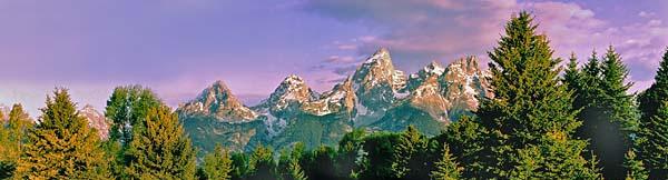


2 2/9/2011 Farm on the plains of Saskatchewan, Canada Central Park Grand Teton National Park, Wyoming Gateway Arch, St. Louis 2


3 Coast of Oregon A farm in Ohio Saguaro National Park, Arizona Chicago View from Dead Horse Point State Park, Utah Shenandoah National Park, VA 3


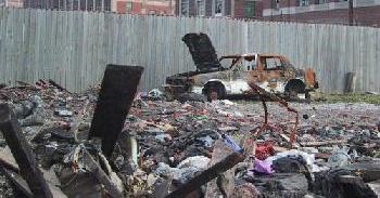


4 Stowe, Vermont Abandoned housing, Baltimore Smog over Los Angeles Recreation and heavy industry near Gary, IN Post-industrial landscape, Detroit Result of the recent Gulf Coast oil spill 4


5 REGION ONE OF THE MOST FUNDAMENTAL GEOGRAPHIC CONCEPTS DEFINITION: A PORTION OF EARTH S SURFACE THAT HAS ONE OF MORE UNIYFYING CHARACTERISTICS. PURPOSES: MAKE THE WORLD MORE INTELLIGIBLE (MORE KNOWABLE ) BY DIVIDING IT INTO UNITS THAT HAVE SOMETHING IN COMMON. ANALOGOUS TO HISTORICAL PERIODS DATA MANAGEMENT Why combine the U.S. and Canada into a single sub-global region? Historic division between Anglo- America and Latin America. Both are former British colonies. Common primacy of the English language and Protestantism. Inherited concepts of parliamentary democracy and land tenure. Similar economic and demographic characteristics. Major trading partners. Generally amiable relations. Shared landforms and climates. Similar patters of land use and urban form. A portion of the wall separating The United States and Mexico 5
")
 44.2 34.6 11.")
 Size Comparison Canada = 3,855,103 sq. mi.")
 Therefore, Canada is larger")

![] POPULATION COMPARISON UNITED STATES = 311,946,632 CANADA =](/docs-images/84/90670505/images/6-5.jpg "34,238,035 U.S. / CANADA RATIO = 9.1 : 1 Sources: U.S data: www.")
6 A portion of the wall separating The United States and Mexico U.S. Canadian Boundary at Waterton Lake (Montana Alberta) Comparative Demographic Data, mid-2007 USA Canada Mexico Infant Mortality GNI PPP Per cap ($ 000) Source: Population Reference Bureau ( Size Comparison Canada = 3,855,103 sq. mi. (World s second largest country) United States = 3.794,083 sq. mi. (World s third largest country) Therefore, Canada is larger by 61,020 sq. mi. [New York + Connecticut = a little less than 60,000 sq. mi.] POPULATION COMPARISON UNITED STATES = 311,946,632 CANADA = 34,238,035 U.S. / CANADA RATIO = 9.1 : 1 Sources: U.S data: January 24, 2011 Canada data: Latest update, October,


 Steel and steel")


7 The Canadian Main Street is the highly populated corridor that extends from Windsor, Ontario, across the northern shores of Lakes Erie and Ontario, and thence along the St. Lawrence River to Quebec City. It includes Toronto, Ottawa, and Montreal, and accounts for well over half of Canada s population. Big Ideas A contested continent Population growth and movements, old and new Increasing human diversity Technological innovation Urban growth and sprawl Resource use and misuse Industrialization and de-industrialization Movers & shapers: Plate tectonics & the Ice Ages Water for movement and well-being Lots of latitude the Tropics to the Arctic A physical environment under assault. Location of St.-Pierre and Miquelon These two small islands are remnants of France s once-vast North American empire. Some technological Innovations of particular geographical importance The cotton gin Barbed wire Canals Railroads (subways) Steel and steel mills Electricity and electrical engines The automobile and internal combustion engine Paved roads The steel plow Tractors and related farming equipment Air conditioners Center-pivot irrigation Ski lifts Containerization Hybrid seed Electronic and wireless communications John Deere ( ) American blacksmith and manufacturer In 1837 he invented the first commercially successful steel plow, which enabled the conversion of prairie to farmland. Founded Deere & Company Prairie soil profile The dark, fertile soils of the prairie could not be cultivated with the wooden plows of European immigrants. Only with the invention of the steel plow were the plains converted from a vast grassland to America s agricultural heartland. 7


8 Henry Ford ( ) Industrialist, automobile manufacturer, and pioneer of the assembly line technique of mass production A Modern Automobile Assembly Line Leaving Las Vegas for the Suburbs Isaac Brekken, The New York Times 8


")


9 2/9/2011 Las Vegas suburb Las Vegas suburb Las Vegas urban sprawl Robert B. Daugherty ( ) Omaha businessman who headed Valmont Industries, a major manufacturing firm. In 1953 he brought the rights i ht to t what h t would ld become center pivot irrigation and popularized the idea. Transformed The Great Plains (and elsewhere) to huge irrigated circles. 9


10 2/9/2011 Center pivot irrigation (Eastern Colorado) Everglades National Park, FL 10


11 Mahogany Hammock Boardwalk Trail Everglades National Park, FL Kauai, Hawaii Gates of the Arctic National Park, AK Baffin Island, Canada 11
Physical Geography of the United States and Canada Chapter 5 A Land of Contrasts
 Physical Geography of the United States and Canada Chapter 5 A Land of Contrasts Land Area Together the U.S. and Canada cover more than 7 million square miles. In total area, Canada ranks 2 nd and the
Five Themes of Geography Project Ms. Kiesel, Per 5. The United States of America
 Five Themes of Geography Project Ms. Kiesel, Per 5 The United States of America Location Absolute Location : The USA is located in the continent of North America in the northern and western hemispheres.
AP Human Geography World Atlas Project
 AP Human Geography World Atlas Project - 2018 Welcome to Robert E. Lee High School and Advanced Placement Human Geography! You are going to thoroughly enjoy this class. It will be a lot of work, but the
Section Reference: Defining The North American Realm and Its Population Clusters Population Clusters
 Package Title: Testbank Course Title: The World Today 7e Chapter Number: Chapter 01 Question type: Multiple-Choice 1) The two leading languages spoken in Canada are: a) English and Spanish b) English and
World Geography Fall 2013 Semester Review Project
 Reporting Category RC 1: History, Government and Citizenship Standard WG.1 History. The student understands how geography and processes of spatial exchange (diffusion) influenced events in the past and
The United States & Canada. A Regional Study of Anglo America
 A Regional Study of Anglo America Landform Regions of the United States & Canada world leaders in agricultural and industrial production because of... VAST LANDS stretch from the Atlantic Ocean on the
Socials Studies. Chapter 3 Canada s People 3.0-Human Geography
 Socials Studies Chapter 3 Canada s People 3.0-Human Geography Physical Geography Study of the natural features of the Earth s surface including landforms, climate, ocean currents and flora and fauna Human
Canadian Mapping Big Book
 Canadian Mapping Big Book Grades 4-6 Written by Lynda Golletz Illustrated by S&S Learning Materials About the Author: Lynda Golletz was an elementary school teacher for thirty-three years. She is the author
TYPES OF GOVERNMENTS
 While the terms country, state, and nation are often used interchangeably, there is a difference. A State (note the capital "S") is a self-governing political entity. The term State can be used interchangeably
Subunit 4.1: 2.5 hours. Subunit 4.2: 2.75 hours. Subunit 4.3: 1.5 hours. Subunit 4.4: 3.5 hours. Subunit 4.5: 1.5 hours Unit 4 Learning Outcomes close
 Unit 4: North America The realm of North America extends from the polar regions of the Arctic in northern Canada and Alaska, all the way south through Mexico and the countries of Central America. Geographers
Grade 9 Social Studies Canadian Identity. Chapter 3 Review Canada s People. Chapter 3: Canada s People
 Grade 9 Social Studies Canadian Identity Chapter 3 Review Canada s People Chapter 3: Canada s People Terms (notes or textbook) Population Distribution Site Factors Seigneurial system Corridors Urbanization
4 th Grade Virginia Studies SOL Review Packet Geography of Virginia. 1. The Algonquian language group of Indians lived in what region of Virginia?
 4 th Grade Virginia Studies SOL Review Packet Geography of Virginia 1. The Algonquian language group of Indians lived in what region of Virginia? A. Allegheny B. Piedmont C. Ridge and Valley D. Tidewater
Simple Solutions Social Studies Level 2. Level 2. Social Studies. Help Pages
 Level 2 Social Studies 147 148 adobe houses with bricks made of clay and straw ancestor a family member who lived before us appoint choose; leaders can appoint others barter trading one thing for another
Massachusetts Curriculum Frameworks Science Grade: 4 - Adopted: 2016
 Main Criteria: Massachusetts Curriculum Frameworks Secondary Criteria: Subjects: Science, Social Studies Grade: 4 Correlation Options: Show Correlated Massachusetts Curriculum Frameworks Science Grade:
Unit 1: Geography. For additional information, refer to this website: 1 G e o g r a p h y
 Unit 1: Geography For additional information, refer to this website: http://mryoungtms.weebly.com/ 1 G e o g r a p h y Continents and Oceans SOL USI. 2a Essential Understanding: Continents are large land
Physical Features of Canada and the United States
 Physical Features of Canada and the United tates 170 ARCTIC OCA Aleutian s 1 1 Bering ea ALAKA Yukon R. Mt. McKinley (20,320 ft. 6,194 m) Gulf of Alaska BROOK RAG RAG Queen Charlotte s R Vancouver O C
Markville. CGC 1DL/PL Geography. Geography of Canada. Natural Environment Unit Test
 Markville CGC 1DL/PL Geography Geography of Canada Natural Environment Unit Test Name: Thinking /10 Knowledge /10 Application /10 Communication /10 Part A: Blanks (1 mark each) Thinking Choose the correct
Landforms. Lesson 1: Physical Geography of Canada Mexico. Canada s mountainous eastern and western edges create a central region of fertile plains.
 Lesson 1: Physical Geography of Canada Mexico Landforms Canada s mountainous eastern and western edges create a central region of fertile plains. Collisions of tectonic plates thrust up a series of sharp-peaked
EQ: Discuss main geographic landforms of the U.S. & Canada and examine varied landforms in relation to their lifestyles.
 EQ: Discuss main geographic landforms of the U.S. & Canada and examine varied landforms in relation to their lifestyles. Places & Terms for Discussion Appalachian Mountains Great Plains Canadian Shield
Physical Features of Canada and the United States
 I VIUAL Physical Features of Canada and the United tates 170 ARCTIC OCA Aleutian s 1 Bering ea ALAKA Yukon R. Mt. McKinley (20,320 ft. 6,194 m) Gulf of Alaska BROOK RAG RAG Queen Charlotte s R Vancouver
MARS AREA SCHOOL DISTRICT CURRICULUM GRADE: Grade 4
 MARS AREA SCHOOL DISTRICT CURRICULUM GRADE: Grade 4 Course Title: Social Studies Brief Description Overview: Students will explore the history, geography, government, and economy of the United States with
The study of Geography and the use of geographic tools help us view the world in new ways.
 S How does Geography help us understand our world? What factors shape the Earth s different environments? 7.1.9 7.2.9 BIG IDEAS COMPETENCIES Text pages or The study of Geography and the use of geographic
A. Geography Students know the location of places, geographic features, and patterns of the environment.
 Learning Targets Elementary Social Studies Grade 5 2014-2015 A. Geography Students know the location of places, geographic features, and patterns of the environment. A.5.1. A.5.2. A.5.3. A.5.4. Label North
[ 1.2 ] Texas Geography
![[ 1.2 ] Texas Geography](/thumbs/78/78091378.jpg "[ 1.2 ] Texas Geography") [ 1.2 ] Texas Geography [ 1.2 ] Texas Geography Learning Objectives Identify how geography helps people understand and organize information about a place. Compare the physical and human characteristics
[ 1.2 ] Texas Geography [ 1.2 ] Texas Geography Learning Objectives Identify how geography helps people understand and organize information about a place. Compare the physical and human characteristics
6/25/2018. Upcoming Classes After Today. Our Only Presentation Day: Monday, July 2
 Upcoming Classes After Today Tuesday (June 26): Pacific Northwest and the Northlands Wednesday (June 27): Geographic Literacy in America; Take-Home Midterm Exam #2 distributed and discussed Thursday (June
A Shift to the Sunbelt
 Adam Giladi 4/1/13 A Shift to the Sunbelt The changing global economy has lead to an increased interconnection between nations and the mass movement of individuals from one area to another. This movement
The Region in Canadian Geography
 The Region in Canadian Geography Reading Course website (www.yorku.ca/anderson) Lists today s reading Laliberté et al (2015) Teaching the geographies of Canada: Reflections on pedagogy, curriculum, and
STAAR Vocabulary Words extracted directly from the standard and/or associated with the instruction of the content within the standard.
 STAAR Vocabulary Words extracted directly from the standard and/or associated with the instruction of the content within the standard. READINESS STANDARDS - World Geography (WG.1) History. The student
Minnesota K-12 Academic Standards in Social Studies. Grade 4: Geography of North America
 Minnesota K-12 Academic s in Social Studies Grade 4: Geography of North America 4 Describe how people take 1. Democratic government action to influence a depends on informed and decision on a specific
Post Test Trimester 1 US & Canada 6th Grade-Study Guide
 Post Test Trimester 1 US & Canada 6th Grade-Study Guide Matching Fill in the blank by writing the letter of the correct term below. a. dominion f. indigenous b. Industrial Revolution g. interdependent
4th Grade U.S. Regional Geography
 4th Grade U.S. Regional Geography Multiple Choice Identify the choice that best completes the statement or answers the question. What does the term mainland mean in the sentence above? A the continent
CANADA S LANDFORM REGIONS
 CANADA S LANDFORM REGIONS Canada s Regions Canada is divided into Eight major regions. A Region is an area that is defined on the basis of the presence or absence of certain characteristics: Age of rock
Guided Reading Activity
 Guided Reading Activity Lesson 1 Physical Features Essential Question: How does geography influence the way people live? A Vast Land Directions: Read the lesson and use your text to decide whether each
Factors Affecting Human Settlement
 Factors Affecting Human Settlement Physical Factors One of the most basic factors affecting settlement patterns is the physical geography of the land. Climate is key, because if a place is too dry, too
ELEMENTS OF BASIC WORLD GEOGRAPHY TABLE OF CONTENTS UNIT 1 THE BASICS OF GEOGRAPHY AND NORTH AMERICA
 TABLE OF CONTENTS UNIT 1 THE BASICS OF GEOGRAPHY AND NORTH AMERICA IMPORTANT WORDS TO KNOW... 1 CHAPTER 1 THE BASICS OF GEOGRAPHY GEOGRAPHY... 2 TOOLS OF GEOGRAPHY... 3 EARTH...4 SEASONS, CLIMATE, AND
World Geography TEKS 2nd Nine Weeks. Unit of Study Regional Studies; U.S. and Canada Regional Studies; Latin America; and Europe
 World Geography TEKS 2nd Nine Weeks Unit of Study Regional Studies; U.S. and Canada Regional Studies; Latin America; and Europe 1) History. The student understands how geography and processes of spatial
LATITUDE. Latitude lines run to, but are measured & The 0 of latitude that circles the earth is called the?
 LATITUDE Latitude lines run to, but are measured & The 0 of latitude that circles the earth is called the? LATITUDE 0 0 Latitude lines run east to west, but are measured north & south The 0 of latitude
HI SUMMER WORK
 HI-201 2018-2019 SUMMER WORK This packet belongs to: Dear Dual Enrollment Student, May 7 th, 2018 Dual Enrollment United States History is a challenging adventure. Though the year holds countless hours
SOCIAL STUDIES GRADE 5. I Can Checklist Office of Teaching and Learning Curriculum Division REGIONS AND PEOPLE OF THE WESTERN HEMISPHERE
 SOCIAL STUDIES REGIONS AND PEOPLE OF THE WESTERN HEMISPHERE GRADE 5 I Can Checklist 2015-2016 Aligned with Ohio s Learning Standards for Social Studies Office of Teaching and Learning Curriculum Division
APPENDIX D QUESTIONS/ACTIVITIES FOR TEACHERS AND STUDENTS
 APPENDIX D QUESTIONS/ACTIVITIES FOR TEACHERS AND STUDENTS The questions below are intended for teachers as they educate K-12 Geography students using the Japanese American relocation centers as their focal
Unit 1: Basics of Geography Test Review
 Name Date Period Unit 1: Basics of Geography Test Review Directions: Reading the following sections and complete the questions, charts, and diagrams. Types of Maps Maps that have a particular theme are
Reference: climate data for Prince George and other locations at the back of this handout
 Name/Date: Socials 9 Unit 2: Cultures, Conflict, and Colonization in British North America 2A Physical Geography of Canada References: Cranny, M. (1998) Crossroads: A Meeting of Nations, Ch. 6 Canadian
Texas Geography. Understanding the physical and human characteristics of our state
 Texas Geography Understanding the physical and human characteristics of our state To understand Texas you must first learn about its Geography. Geography- The study of the world, its people, and the interaction
What is it like living in each of the regions in Alberta?
 Chapter 1 4.1 Alberta: A Sense of the Land I can show how parts of Alberta s physical geography and climate are important to the landscapes and environment of Alberta. I can show where Alberta located
Warmup. geography compass rose culture longitude
 Warmup geography compass rose culture longitude ecosystem latitude 1. study of the special physical and human characteristics of a place or region 2. learned system of shared beliefs, traits, and values
Explain the impact of location, climate, natural resources, and population distribution on Europe. a. Compare how the location, climate, and natural
 SS6G10 Explain the impact of location, climate, natural resources, and population distribution on Europe. a. Compare how the location, climate, and natural resources of Germany, the United Kingdom and
September 14, 2013 Objective: How does geography impact history? What important features exist that have shaped societies?
 Lowenhaupt 1 September 14, 2013 Objective: How does geography impact history? What important features exist that have shaped societies? Warm-Up: In your binder, answer the following question: Imagine you
Unit 2. United States Physical Geography
 Unit 2 United States Physical Geography Physical Geography U.S. extends from the Atlantic to Pacific U.S. is the 3rd largest country U.S. has fertile soils, vast forests, and variety of minerals All major
discussion of North America s physical features, including its landforms and bodies of
 Chapter 7 Natural Environments of North America Chapter 7 focuses on the natural environments of North America. The chapter opens with a discussion of North America s physical features, including its landforms
Following the Civil War, many Americans and Europeans continued to move into the WEST
 1860-1900 Following the Civil War, many Americans and Europeans continued to move into the WEST as far as the eye can see millions of acres of treeless grassland. Between the Mississippi River and the
Introducing North America
 Introducing North America I. Quick Stats Includes U.S. & Canada U.S consists of 50 States Federal Government Democracy 4 th in world w/ land area 3 rd in population Economic leader of free world II. Major
Grade Five Social Studies Assessment Regions/Native Americans
 Name Grade Five Social Studies Assessment Regions/Native Americans Use the map below to answer questions 1 and 2 1. (Geo 1) For this location give the name of the city found there. 38 N, 100 W a. Scottsbluff
Regional Geography C. LANGDON WHITE. Professor Emeritus Stanford University EDWIN J. FOSCUE TOM L. MCKNIGHT
 Regional Geography of Anglo-America Sixth Edition C. LANGDON WHITE Professor Emeritus Stanford University EDWIN J. FOSCUE Late of Southern Methodist University TOM L. MCKNIGHT Professor of Geography University
Social Studies 9 UNIT 2 GEOGRAPHIC INFLUENCES ON IDENTITY: PLACE AND PEOPLE
 Social Studies 9 UNIT 2 GEOGRAPHIC INFLUENCES ON IDENTITY: PLACE AND PEOPLE The Structure of the Earth To understand the forces that create Canada's physical landscape we must understand the structure
AP Human Geography AP EXAM Free Response Questions and Possible Future Questions
 AP Human Geography AP EXAM Free Response Questions and Possible Future Questions FRQ Exam Questions: Population & Migration 2003- European Migration and Demographic Transition Model 2004- Population Pyramids
August 19 students first day of class (M1-M17) Place. Movement. Human- Environment Interaction. Cartography. Elevation
 Place. Movement. Human- Environment Interaction. Cartography. Elevation") Month August 2010 6 th Grade Western Hemisphere 2010-2011 Curriculum Map Pacing Vocabulary Assessment Resources Content Skills Mapmaster 7. Location August 19 Skills students first Handbook 7.6.1 Region
Month August 2010 6 th Grade Western Hemisphere 2010-2011 Curriculum Map Pacing Vocabulary Assessment Resources Content Skills Mapmaster 7. Location August 19 Skills students first Handbook 7.6.1 Region
World Geography. BY MARK STANGE and REBECCA LARATTA
 BY MARK STANGE and REBECCA LARATTA COPYRIGHT 2002 Mark Twain Media, Inc. ISBN 1-58037-205-8 Printing No. CD-1551 Mark Twain Media, Inc., Publishers Distributed by Carson-Dellosa Publishing Company, Inc.
AP Human Geography. Course Outline Geography: Its Nature and Perspectives: Weeks 1-4
 AP Human Geography The Course The AP Human Geography course is designed to provide secondary students with the equivalent of one semester of a college introductory human geography class. The purpose of
Answers to British Columbia Quizzes
 Answers to British Columbia Quizzes p. 1 Test Your Knowledge What do you remember from your review of the British Columbia section of the E-atlas? 1. What percentage of Canada's total area does British
Terms. divide headwaters tributary fall line fishery
 Chapter 5 Preview Section 1 The Land Objectives Identify some key similarities and differences in the physical geography of the United States and Canada. Explain why rivers have played such an important
Social Studies Curriculum Sixth Grade
 Social Studies Curriculum Sixth Grade A. History Students will examine the key historic movements, events, and figures that contributed to the development of modern Europe and American nations from early
Meteorology 110. Lab 1. Geography and Map Skills
 Meteorology 110 Name Lab 1 Geography and Map Skills 1. Geography Weather involves maps. There s no getting around it. You must know where places are so when they are mentioned in the course it won t be
Cities, Countries, and Population
 Cities, Countries, and Population After the world industrialized, better food, improved sanitation, and new medicines caused the world population to soar. To understand how heavily populated an area is,
GC1DR Exam Review 2013
 GC1DR Exam Review 2013 Name: Your exam is just around the corner! By completing this review, you will be EXTREMELY well prepared to write this exam. Part A ON A SEPARATE PIECE OF PAPER, please complete
SS 11: Human Geography
 SS 11: Human Geography INTRODUCTION TO HUMAN GEOGRAPHY & POPULATION Introduction to Human Geography Geography is the systematic study of the spatial patterns of all phenomena on or near the earth s surface.
11/14/2017. Key City Focus: Phoenix
 Semester Project Reminder Semester Project presentations begin on Monday, November 20 (and continue on Monday, November 27 and Wednesday, November 27). See the presentation schedule posted online for your
Curriculum Unit. Instructional Unit #1
 Curriculum Unit Name of Course: AP Human Geography Grade Level(s): 9-12 Brief Description (Course Catalog): The purpose of the AP Human Geography course is to introduce students to the systematic study
HUDSONVILLE MIDDLE SCHOOL COURSE FRAMEWORK
 HUDSONVILLE MIDDLE SCHOOL COURSE FRAMEWORK COURSE/SUBJECT 7 th Grade Social Studies UNIT PACING Unit 1 ~ Geography of the Western World: Europe, Latin America, The United States and Canada September 6
Oklahoma Academic Standards Science Grade: 6 - Adopted: 2014
 Main Criteria: Oklahoma Academic Standards Secondary Criteria: Subjects: Science, Social Studies Grade: 6 Correlation Options: Show Correlated OK.6-LS. Oklahoma Academic Standards Science Grade: 6 - Adopted:
Anoka Hennepin K 12 Curriculum Unit Plan
 Anoka Hennepin K 12 Curriculum Unit Plan Department: Social Studies Grade Level: 4 Unit Title: Geographic Investigations Trimester: 2 and 3 (16) 55 minute lessons (can be (32) 25 minute lessons) Unit Summary:
Chapter 6, Part Colonizers arriving in North America found extremely landscapes. It looked different to region showing great.
 Social Studies 9 Unit 1 Worksheet Chapter 6, Part 1. 1. Colonizers arriving in North America found extremely landscapes. It looked different to region showing great. 2. The Earth is years old and is composed
PERCEPTION and Focus on Maps. Focus on Maps 8/29/2014. English and Dutch Maps from the 1600s and 1680 British Maps of N. Am.
 PERCEPTION English and Dutch Maps from the 600s The Nature of New York Dutch67 Prof. Anthony Grande English 67 Copyright 04 AFG 676 and 680 British Maps of N. Am. 70 and 776 4 Focus on Maps Maps are geographers
name and locate the world s seven continents and five oceans
 Subject: Geography Activities National Curriculum Objectives One Progression of Skills Name the 7 continents and 5 oceans 3D Jigsaw task to locate continents and seas name and locate the world s seven
About places and/or important events Landmarks Maps How the land is, hills or flat or mountain range Connected to maps World Different countries
 What do you think you know about geography? About places and/or important events Landmarks Maps How the land is, hills or flat or mountain range Connected to maps World Different countries What do you
Academic Vocabulary CONTENT BUILDER FOR THE PLC WORLD GEOGRAPHY
 Academic Vocabulary CONTENT BUILDER FOR THE PLC WORLD GEOGRAPHY : academic vocabulary directly taken from the standard STANDARD WG.1A analyze the effects of physical and human geographic patterns and processes
Climate Change in Canada
 1 Climate Change in Canada Climate change is an urgent, global concern. The implications of climate change are significant and far reaching, with the potential of impacting future generations throughout
Scope & Sequence Grade: Four Subject: Social Studies Revised 3/30/ st Quarter (44 Days)
") 1 st Quarter (44 Days) Describe some of the major landforms and waterways in. Describe 4.7 B, 4.9 B, 4.6 A, 4.6 B, 4.22 B, Week 1 Chapter1: The geography of the ways people collect water from the Earth.
1 st Quarter (44 Days) Describe some of the major landforms and waterways in. Describe 4.7 B, 4.9 B, 4.6 A, 4.6 B, 4.22 B, Week 1 Chapter1: The geography of the ways people collect water from the Earth.
Grade 9 Social Studies Canadian Identity. Chapter 2 Review Canada s Physical Landscape
 Grade 9 Social Studies Canadian Identity Chapter 2 Review Canada s Physical Landscape Name: Unit 1: Empowerment Terms (notes or textbook) 1. Core 2. Crust 3. Mantle 4. Magma 5. Continental drift 6. Plate
Geography Long Term Plan 2018
 Geography Long Term Plan 2018 Geography Co-ordinator: Megan Frost A high-quality geography education should inspire in pupils a curiosity and fascination about the world and its people that will remain
ORLD G EOGRAPHY BASIC. NotB oring. Inventive Exercises to Sharpen Skills and Raise Achievement. Imogene Forte & Marjorie Frank
 The BASIC NotB oring SERIES SOCIAL IP 402-0 STUDIES SKILLS MIDDLE GRADES ORLD G EOGRAPHY Inventive Exercises to Sharpen Skills and Raise Achievement Series Concept & Development by Imogene Forte & Marjorie
The Five Themes of Geography Identification Slide Show. Developed by Joseph Naumann
 The Five Themes of Geography Identification Slide Show Developed by Joseph Naumann 1 5 Themes & Geographic Questions PLACE LOCATION HUMAN ENVIRONMENT/ INTERACTION REGION MOVEMENT 2 Location determining
4th Grade Social Studies First Nine Weeks
 4th Grade Social Studies First Nine Weeks Multiple Choice Identify the choice that best completes the statement or answers the question. 1 Name the mountains that are located in the eastern United States.
Unit 1 Test - Version A
 Unit 1 Test - Version A 1. Approximately, how many degrees of longitude equal one time zone change? a. 5 b. 10 c. 15 d. 20 e. 25 2. The city of Lewisville has a population of 1,000 people living in 100
Urban Foundations. Early American Cities. Early American Cities. Early American Cities. Cities in America to 1945
 Urban Foundations Cities in America to 1945 Early American Cities The design of early American cities was highly influenced by European traditions The roots of many of these traditions can in turn be traced
Generic Success Criteria
 Generic Success Criteria Significance I can identify a short term and long term impact that a development/event/issue has/had locally/globally. I can discuss (verbally, graphically, etc.) how a development/event/issue
Prentice Hall. World Explorer: People, Places, Cultures Grade 7. Oklahoma Priority Academic Student Skills (PASS) for Grade 7 World Geography
 for Grade 7 World Geography") Prentice Hall World Explorer: People, Places, Cultures 2007 Grade 7 C O R R E L A T E D T O for Grade 7 1. Locate, gather, analyze, and apply information from primary and secondary sources. WORLD GEOGRAPHY
Prentice Hall World Explorer: People, Places, Cultures 2007 Grade 7 C O R R E L A T E D T O for Grade 7 1. Locate, gather, analyze, and apply information from primary and secondary sources. WORLD GEOGRAPHY
Warm up: (8 min) Use the Map, On the Prom (Color) Paper (Blk/White) and answer the questions on your paper
 Use the Map, On the Prom (Color) Paper (Blk/White) and answer the questions on your paper") Warm up: (8 min) Use the Map, On the Prom (Color) Paper (Blk/White) and answer the questions on your paper TX History: Mapping and Geography of Texas: We will discuss some slides and write notes on others
Warm up: (8 min) Use the Map, On the Prom (Color) Paper (Blk/White) and answer the questions on your paper TX History: Mapping and Geography of Texas: We will discuss some slides and write notes on others
Chapter 32. Australia & New Zealand
 Chapter 32 Australia & New Zealand Lesson 1: Physical Geography of Australia & New Zealand Landforms Australia lies between the Pacific and Indian Oceans in the Southern Hemisphere. Although an island,
World Geography Mid Term Review 2016
 World Geography Mid Term Review 2016 1.Latitude and Longitude Lines of latitude run and. The zero-degree line is the. Line of longitude run and. The zero degree line is called the. 2. Map Projections What
Chapter 9: Urban Geography
 Chapter 9: Urban Geography The Five Steps to Chapter Success Step 1: Read the Chapter Summary below, preview the Key Questions, and Geographic Concepts. Step 2: Complete the Pre-Reading Activity (PRA)
Grade 7 History Mr. Norton
 Grade 7 History Mr. Norton Section 1: Thinking Geographically Section 2: Land and Climates of the United States Section 3: The Tools of History Section 4: Economics and Other Social Sciences Grade 7 History
Unit 1: Geography CLASS WEBSITE: QUIZLET GAMES: ONLINE RESOURCES
 Unit 1: Geography ONLINE RESOURCES CLASS WEBSITE: HTTPS://MRYOUNGTMS.WEEBLY.COM/GEOGRAPHY.HTML QUIZLET GAMES: HTTPS://QUIZLET.COM/JOIN/MSFYY94T5 1 G e o g r a p h y Continents and Oceans The Seven Continents
Landforms and Bodies of Water
 Chapter 5, Section 1 For use with textbook pages 115 120. The Land Terms to Know divide A high point or ridge that determines the direction that rivers flow (page 118) headwaters The source waters of a
5th social studies geography (5thsocstud_geography)
") Name: Date: 1. Many of the Native Americans who lived on the Great Plains were nomadic people. Why did they move from place to place? A. They were finding new areas to mine. B. They were looking for fertile
Name: Date: 1. Many of the Native Americans who lived on the Great Plains were nomadic people. Why did they move from place to place? A. They were finding new areas to mine. B. They were looking for fertile
GEOGRAPHY OF CANADA 1. PHYSICAL GEOGRAPHY
 GEOGRAPHY OF CANADA 1. PHYSICAL GEOGRAPHY 1.1. CANADIAN SHIELD 1.2. VOLCANOES 1.3. WESTERN CORDILLERA 1.4. CANADIAN ARCTIC 1.5. CANADIAN INTERIOR PLAINS 1.6. GREAT LAKES AND ST LAWRENCE LOWLANDS 1.7. APPALACHIAN
Chapter 32. Australia & New Zealand
 Chapter 32 Australia & New Zealand Lesson 1: Physical Geography of Australia & New Zealand Landforms Australia lies between the Pacific and Indian Oceans in the Southern Hemisphere. Although an island,
K- 5 Academic Standards in. Social Studies. June 2013
 K- 5 Academic s in Social Studies June 2013 Word Tables of s ONLY This Word version of the 2.17.12 social studies standards (DRAFT for Rulemaking 2.17.12) document contains the standards ONLY; no explanatory
Population And Settlement Part I
 Population And Settlement Part I 0011 0010 1010 1101 0001 0100 1011 4 12 Think of the earth as a living organism that is being attacked by billions of bacteria whose numbers double every forty years. Either
This image cannot currently be displayed. Course Catalog. History and Geography Glynlyon, Inc.
 This image cannot currently be displayed. Course Catalog History and Geography 2016 Glynlyon, Inc. History and Geography Table of Contents COURSE OVERVIEW... 1 UNIT 1: OUR EARTH... 1 UNIT 2: SEAPORT CITIES...
6. What is the absolute location (latitude and longitude) and relative location of your home town or the town in which you attend school?
 and relative location of your home town or the town in which you attend school?") Social Studies 10 Chapter 1 Worksheet Directions: Be sure to complete reading the chapter before you attempt these questions. Be aware that the Chapter Test will cover everything you read in the chapter,
Social Studies 10 Chapter 1 Worksheet Directions: Be sure to complete reading the chapter before you attempt these questions. Be aware that the Chapter Test will cover everything you read in the chapter,