Highly Persisting Patch Formation Areas and Their Interannual Variability in the Gulf of Finland, the Baltic Sea.
|
|
|
- Miles Hutchinson
- 5 years ago
- Views:
Transcription
1 Andrea Giudici and Tarmo Soomere Institute of Cybernetics - Tallinn University of Technology Highly Persisting Patch Formation Areas and Their Interannual Variability in the Gulf of Finland, the Baltic Sea. Last reviewed: 05/06/ :56
2 Outline 1. Introduction 2. Spatial domain 3. + methods 4. Results 5. Conclusions


3 Introduction - Under normal conditions, the sea surface layer is extremely heterogeneous across different spatial and temporal scales. - Variations in concentrations of natural biochemical or substances of anthropogenic origin may deeply influence the underlying ecosystems. - The impact of such variations in concentration (referred to as patches) may have positive or negative impact. Dredging Negative impact is often of anthropogenic origin: Dumping Discharge of pollutants Aquafarming

![Myrberg, 2009] Frequently hosts up- and downwelling phenomena](/docs-images/83/88608448/images/4-3.jpg "[Lehmann and Myrberg, 2007] Extremely dense ship traffic throughout")
4 Spatial domain Estuarine area which shows extremely complex dynamics High proportion of vertical motions of water masses [Leppäranta and Myrberg, 2009] Frequently hosts up- and downwelling phenomena [Lehmann and Myrberg, 2007] Extremely dense ship traffic throughout the year.
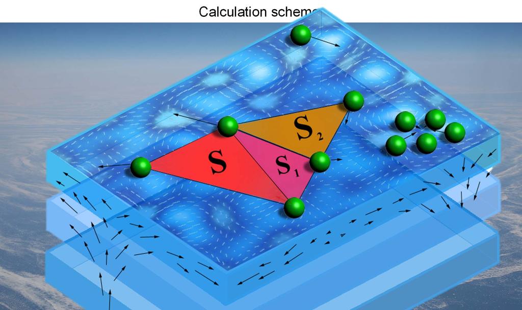
5 We explore a convenient way to identify areas of natural increase in concentration of substances on the sea surface, by means of the recently developed measure of the Finite Time Compressibility (FTC). This measure is retrieved starting from geometrical properties of conveniently defined patches of floating matter, which are tracked through their drifting on the sea surface, under the combined effect of winds and currents. Key foundation for this measure is to account for time correlations of the realistic flows. High values of divergence at a certain location aren t enough for strong patch-formation processes to take place they take some time. Such processes become effective if the area of high divergence moves together with the flow. The measure of FTC has the same basic properties of flow compressibility but is able to integrate the contributions of moving areas of high divergence to the patch-formation process.
6

7
8
9
10
11
12
13


14 0,1. Rapid and significant increase in concentration occurs when this value exceeds the threshold of ~0.7
15 - Our analysis relies on the output of OAAS ocean model [Andrejev and Sokolov, 1989] - Spatial resolution 1NM - Temporal resolution 3 hours vector information /day.
16


17 - Resulting maps for each batch are scanned for areas where the local value of FTC exceeds the threshold of 0.7, which is the point after which patch formation starts to occur. - For each batch, we produce a persistency map. - Each wet grid cell of such persistency maps represents the percentage of time during which that very grid cell showed FTC 0.7, over the considered time span. - By performing a large number of FTC batches, we obtain at this step a large set of persistency maps, which will be grouped together depending on their overall length. - Data analysis is produced over this set.


18 Results - Averaging instantaneous values of FTC over a long time allows us to identify and focus only on those areas that systematically show heavy clusterization potential. - Averaging over 90 or 180 days long batches of maps smoothens out many local features which show up only on individual maps. - The resulting averaged distributions show several areas of appreciable size which host above-clustering-threshold values of FTC in the Gulf of Finland.
19 Results - Some of these areas show this characteristic for over one third of the time. - They are concentrated along coastal regions, mostly along the southern coast of the Gulf. - One of these areas is located in the central part of the Gulf, between the islands of Gogland, Bolshoy Tyuters and Moshchny. - Vertically averaged profiles confirm this asymmetry, implying that the patch formation processes are more likely to occur in the southern parts of the Gulf. - The presence of area 8 is evidently connected with a persistent area of convergence of the overall cyclonic circulation of the gulf with the voluminous fresh water inflow due to the river Neva.

20 Conclusions We presented an approach to the problem of detection of areas of natural patchformation. This approach matches convergence areas and Lagrangian drift of the forming patches in the surface layer. We highlighted a rich pattern of possible patch-formation regions in the Gulf of Finland. Detected areas show low interannual variations of their basic properties, even if no evident strong pattern can be seen at this stage. Several of the nine distinguished areas match the corresponding locations of frequent downwelling regions. Some of them are located in a central area of the Gulf, possibly indicating long-term convergence areas of surface currents.


21
Frequencies and pathways forcing major inflows to the Baltic Sea
 12th Polish German Seminar The Baltic Sea at the middle of the 21st Century 13.-14.10.2014, Sopot, Poland Frequencies and pathways forcing major inflows to the Baltic Sea Andreas Lehmann, Piia Post*, Katharina
Chapter 10 Applications of the Inverse Problem of Pollution Propagation
 Chapter 10 Applications of the Inverse Problem of Pollution Propagation Tarmo Soomere Abstract The quantification of the potential of different offshore domains to serve as a remote source of danger to
3.3 Classification Diagrams Estuarine Zone Coastal Lagoons References Physical Properties and Experiments in
 Contents 1 Introduction to Estuary Studies... 1 1.1 Why to Study Estuaries?.... 1 1.2 Origin and Geological Age... 4 1.3 Definition and Terminology... 7 1.4 Policy and Actions to Estuary Preservation....
Cape Verde. General Climate. Recent Climate. UNDP Climate Change Country Profiles. Temperature. Precipitation
 UNDP Climate Change Country Profiles C. McSweeney 1, M. New 1,2 and G. Lizcano 1 1. School of Geography and Environment, University of Oxford. 2. Tyndall Centre for Climate Change Research http://country-profiles.geog.ox.ac.uk
Ocean Mixing and Climate Change
 Ocean Mixing and Climate Change Factors inducing seawater mixing Different densities Wind stirring Internal waves breaking Tidal Bottom topography Biogenic Mixing (??) In general, any motion favoring turbulent
New perspectives of climate change impacts on marine anthropogenic radioactivity in Arctic regions
 New perspectives of climate change impacts on marine anthropogenic radioactivity in Arctic regions M. Karcher 1,3, I. Harms 2, R. Gerdes 3, W.J.F. Standring 4, M. Dowdall 4, P. Strand 4 1 O.A.Sys Ocean
CHAPTER 7 Ocean Circulation Pearson Education, Inc.
 CHAPTER 7 Ocean Circulation 2011 Pearson Education, Inc. Types of Ocean Currents Surface currents Deep currents 2011 Pearson Education, Inc. Measuring Surface Currents Direct methods Floating device tracked
Managing plastic litter in the marine environment with the help of ocean models
 Managing plastic litter in the marine environment with the help of ocean models Jun She, Jens Murawski, Kostas Tsiaras, Asbjørn Christiansen, Urmas Lips and other WP1 partners BOOS Scientific Workshop
Circulation patterns in the Gulf of Finland derived from the EOF analysis of model results
 Boreal Environment Research 16 (suppl. A): 84 12 211 ISSN 1239-695 (print) ISSN 1797-2469 (online) helsinki 31 March 211 Circulation patterns in the Gulf of Finland derived from the EOF analysis of model
Storm surges in the easternmost Gulf of Finland during operation of the Flood Protection Barrier of St. Petersburg
 Storm surges in the easternmost Gulf of Finland during operation of the Flood Protection Barrier of St. Petersburg V.Ryabchenko 1, P.Andreev 2, A.Averkiev 3, A.Dvornikov 1, K.Klevanny 4, V.Tsepelev 2 1
Characteristics and variability of the vertical thermohaline structure in the Gulf of Finland in summer
 Boreal Environment Research 16 (suppl. A): 73 83 2011 ISSN 1239-6095 (print) ISSN 1797-2469 (online) helsinki 31 March 2011 Characteristics and variability of the vertical thermohaline structure in the
Towards an improved mechanistic understanding of major saltwater inflows into the Baltic Sea. Background. back to Navigation
 Background page 1/21 major Baltic inflow = voluminous inflow of highly saline water into the Baltic Sea importance hydrographic structure and salinity balance deep water oxygenation (ecosystems!) characteristics
Mozambique. General Climate. UNDP Climate Change Country Profiles. C. McSweeney 1, M. New 1,2 and G. Lizcano 1
 UNDP Climate Change Country Profiles Mozambique C. McSweeney 1, M. New 1,2 and G. Lizcano 1 1. School of Geography and Environment, University of Oxford. 2.Tyndall Centre for Climate Change Research http://country-profiles.geog.ox.ac.uk
The use of high-resolution bathymetry for circulation modelling in the Gulf of Finland
 Estonian Journal of Engineering, 2010, 16, 3, 187 210 doi: 10.3176/eng.2010.3.01 The use of high-resolution bathymetry for circulation modelling in the Gulf of Finland Oleg Andrejev a, Alexander Sokolov
WIND EFFECTS ON CHEMICAL SPILL IN ST ANDREW BAY SYSTEM
 WIND EFFECTS ON CHEMICAL SPILL IN ST ANDREW BAY SYSTEM PETER C. CHU, PATRICE PAULY Naval Postgraduate School, Monterey, CA93943 STEVEN D. HAEGER Naval Oceanographic Office, Stennis Space Center MATHEW
Coastal Ocean Circulation Experiment off Senegal (COCES)
") DISTRIBUTION STATEMENT A. Approved for public release; distribution is unlimited. Coastal Ocean Circulation Experiment off Senegal (COCES) Pierre-Marie Poulain Istituto Nazionale di Oceanografia e di Geofisica
DISTRIBUTION STATEMENT A. Approved for public release; distribution is unlimited. Coastal Ocean Circulation Experiment off Senegal (COCES) Pierre-Marie Poulain Istituto Nazionale di Oceanografia e di Geofisica
Lake Pyykösjärvi water quality model Timo Huttula and Ninni Liukko Freshwater Centre, Finnish Environment Institute, Finland
 Lake Pyykösjärvi water quality model Timo Huttula and Ninni Liukko Freshwater Centre, Finnish Environment Institute, Finland timo.huttula@ymparisto.fi Abstract: Lake Pyykösjärvi waters are eutrophied with
Sustained observations of mesoscale and submesoscale surface circulation
 Sustained observations of mesoscale and submesoscale surface circulation off the U.S. West Coast Sung Yong Kim 1,*, Eric Terrill 1, Bruce Cornuelle 1, Burt Jones 2, Libe Washburn 3, Mark Moline 4, Jeffrey
Currents & Gyres Notes
 Currents & Gyres Notes Current A river of water flowing in the ocean. 2 Types of Currents Surface Currents wind-driven currents that occur in the top 100m or less Deep Currents density-driven currents
5 Atmospheric Disturbances 7 1.Cyclones- tropical and temperate and associated weather conditions. 2.Anticyclones and associated weather conditions.
 5 Atmospheric Disturbances 7 1.Cyclones- tropical and temperate and associated weather conditions. 2.Anticyclones and associated weather conditions. atmospheric disturbances (weather systems) that are
Long-term Change of Ocean Productivity: A case study in the Bay of Bengal
 Long-term Change of Ocean Productivity: A case study in the Bay of Bengal The 3 rd Asian /12 th Korean-Japan Workshop on Ocean Color Dr.Md.Latifur Rahman Sarker, UTM, Malaysia & RU, Bangladesh & Noor Saadah
Climate changes in Finland, but how? Jouni Räisänen Department of Physics, University of Helsinki
 Climate changes in Finland, but how? Jouni Räisänen Department of Physics, University of Helsinki 19.9.2012 Outline Some basic questions and answers about climate change How are projections of climate
Interactive comment on River bulge evolution and dynamics in a non-tidal sea Daugava River plume in the Gulf of Riga, Baltic Sea by E. Soosaar et al.
 Ocean Sci. Discuss., 12, C1547 C1555, 2016 www.ocean-sci-discuss.net/12/c1547/2016/ Author(s) 2016. This work is distributed under the Creative Commons Attribute 3.0 License. Interactive comment on River
Carbon Exchanges between the Continental Margins and the Open Ocean
 Carbon Exchanges between the Continental Margins and the Open Ocean Outline: 1. Introduction to problem 2. Example of how circulation can export carbon to open ocean 3. Example of how particle transport
Organisms in the Ocean
 Oceans Objective 8.E.1.2 Summarize evidence that Earth's oceans are a reservoir of nutrients, minerals, dissolved gases, and life forms: estuaries, marine ecosystems, upwelling, and behavior of gases in
Will a warmer world change Queensland s rainfall?
 Will a warmer world change Queensland s rainfall? Nicholas P. Klingaman National Centre for Atmospheric Science-Climate Walker Institute for Climate System Research University of Reading The Walker-QCCCE
Outline of 4 Lectures
 Outline of 4 Lectures 1. Sept. 17, 2008: TC best track definition and datasets, global distribution of TCs; Review of history of meteorological satellites, introducing different orbits, scanning patterns,
Page 1. Name:
 Name: 1) As the difference between the dewpoint temperature and the air temperature decreases, the probability of precipitation increases remains the same decreases 2) Which statement best explains why
Carbon pathways in the South Atlantic
 Carbon pathways in the South Atlantic Olga T. Sato, Ph.D. Paulo Polito, Ph.D. olga.sato@usp.br - polito@usp.br Oceanographic Institute University of São Paulo Olga Sato and Paulo Polito (IOUSP) Carbon
New Zealand Climate Update No 226, April 2018 Current climate March 2018
 New Zealand Climate Update No 226, April 2018 Current climate March 2018 March 2018 was characterised by significantly higher pressure than normal to the east of New Zealand. This pressure pattern, in
Ice Phenomena on the Lower Vistula
 Geophysica (2011), 47(1 2), 57 67 Ice Phenomena on the Lower Vistula Wojciech Majewski Institute of Meteorology and Water Management, 61 Podleśna str. 01-673 Warsaw, Poland (Received: June 2010; Accepted:
The Ocean Floor THE VAST WORLD OCEAN
 OCEANOGRAPHY Name Color all water LIGHT BLUE. Color all land LIGHT GREEN. Label the 5 Oceans: Pacific, Atlantic, Indian, Arctic, Antarctic. Label the 7 Continents: N.America, S.America, Europe, Asia, Africa,
DISTRIBUTION STATEMENT A. Approved for public release; distribution is unlimited. Lateral Mixing
 DISTRIBUTION STATEMENT A. Approved for public release; distribution is unlimited. Lateral Mixing Eric A. D Asaro APL/UW 1013 NE 40 th Str Seattle, WA 98105 phone: (206) 685-2982 fax: (206) 543-6785 email:
Identification of flow structures by Lagrangian trajectory methods
 Identification of flow structures by Lagrangian trajectory methods Tomas Torsvik Wave Engineering Laboratory Institute of Cybernetics at Tallinn University of Technology Non-homogeneous fluids and flows
The physical oceanography of the Gulf of Finland: a review
 BOREAL ENVIRONMENT RESEARCH 3: 97 125 ISSN 1239-6095 Helsinki 6 November 1998 1998 The physical oceanography of the Gulf of Finland: a review Pekka Alenius 1), Kai Myrberg 1) and Alexei Nekrasov 2) 1)
Introduction. One way to monitor the status of this energy is though monitoring sea surface
 Sears 1 Understanding Hurricane Intensity Using Sea Surface Height and Temperature Information John Sears (Plymouth State University) Robbie Hood (NASA-MSFC) Frank LaFontaine (Raytheon) Abstract Warmer
Efficacy Evaluation of Data Assimilation for Simulation Method of Spilled Oil Drifting
 Proceedings of 5th PAAMES and AMEC2012 Dec. 10-12, 2012, Taiwan Paper No. SEPAS-05 Efficacy Evaluation of Data Assimilation for Simulation Method of Spilled Oil Drifting Satoaki TSUTSUKAWA, Hiroyoshi SUZUKI
MESOSCALE MODELLING OVER AREAS CONTAINING HEAT ISLANDS. Marke Hongisto Finnish Meteorological Institute, P.O.Box 503, Helsinki
 MESOSCALE MODELLING OVER AREAS CONTAINING HEAT ISLANDS Marke Hongisto Finnish Meteorological Institute, P.O.Box 503, 00101 Helsinki INTRODUCTION Urban heat islands have been suspected as being partially
Severe storms over the Mediterranean Sea: A satellite and model analysis
 National Research Council of Italy Severe storms over the Mediterranean Sea: A satellite and model analysis V. Levizzani, S. Laviola, A. Malvaldi, M. M. Miglietta, and E. Cattani 6 th International Precipitation
Periodic variability of currents induced by topographically trapped waves in the coastal zone in the Gulf of Finland*
 Periodic variability of currents induced by topographically trapped waves in the coastal zone in the Gulf of Finland* OCEANOLOGIA, 48 (S), 6. pp. 7 9. C 6, by Institute of Oceanology PAS. KEYWORDS Water
C o a s t a l p o l l u t i o n
 C o a s t a l p o l l u t i o n Copernicus for Coastal Zone Management and Marine Environment Monitoring Service Copernicus EU Copernicus EU Copernicus EU www.copernicus.eu I N T R O D U C T I O N Main
Oceans I Notes. Oceanography
 Oceans I Notes Outlines on the front table Oceanography the science of our oceans that mixes biology, geology, chemistry, and physics (among other sciences) to unravel the mysteries of our seas. Divisions
Cuba. General Climate. Recent Climate Trends. UNDP Climate Change Country Profiles. Temperature. C. McSweeney 1, M. New 1,2 and G.
 UNDP Climate Change Country Profiles Cuba C. McSweeney 1, M. New 1,2 and G. Lizcano 1 1. School of Geography and Environment, University of Oxford. 2. Tyndall Centre for Climate Change Research http://country-profiles.geog.ox.ac.uk
Antigua and Barbuda. General Climate. Recent Climate Trends. UNDP Climate Change Country Profiles. Temperature
 UNDP Climate Change Country Profiles Antigua and Barbuda C. McSweeney 1, M. New 1,2 and G. Lizcano 1 1. School of Geography and Environment, University of Oxford. 2. Tyndall Centre for Climate Change Research
Sediments: a source of chemicals for the marine environment, in more than one way. Jos van Gils 1, Remi Laane 1, Kees van de Ven 2
 Sediments: a source of chemicals for the marine environment, in more than one way Jos van Gils 1, Remi Laane 1, Kees van de Ven 2 1 DELTARES, The Netherlands 2 RIJKSWATERSTAAT Water Service, The Netherlands
Wednesday, November 15, 2017
 Wednesday, November 15, 2017 Northern Europe: Physical Geography Objective: Locate and describe the various traditional regions of Western Europe. Outline how the physical geography varies from region
Rising Sea Levels: Time for Proactive Action in Florida and the Caribbean?
 Rising Sea Levels: Time for Proactive Action in Florida and the Caribbean? Dr. Alan Fyall and Dr. Thomas Wahl National Center for Integrated Coastal Research, University of Central Florida Dr. Roberta
Gulf of Finland Year 2014 An overview of activities and further visions
 Gulf of Finland Year 2014 An overview of activities and further visions The Gulf of Finland Maritime Assembly in Turku 6.-7.11.2014 Kai Myrberg Project Manager, Gulf of Finland Year 2014 Finnish Environment
North Pacific Climate Overview N. Bond (UW/JISAO), J. Overland (NOAA/PMEL) Contact: Last updated: September 2008
, J. Overland (NOAA/PMEL) Contact: Last updated: September 2008") North Pacific Climate Overview N. Bond (UW/JISAO), J. Overland (NOAA/PMEL) Contact: Nicholas.Bond@noaa.gov Last updated: September 2008 Summary. The North Pacific atmosphere-ocean system from fall 2007
North Pacific Climate Overview N. Bond (UW/JISAO), J. Overland (NOAA/PMEL) Contact: Nicholas.Bond@noaa.gov Last updated: September 2008 Summary. The North Pacific atmosphere-ocean system from fall 2007
WRF Model Simulated Proxy Datasets Used for GOES-R Research Activities
 WRF Model Simulated Proxy Datasets Used for GOES-R Research Activities Jason Otkin Cooperative Institute for Meteorological Satellite Studies Space Science and Engineering Center University of Wisconsin
Climate change in the Baltic Sea Basin
 Climate change in the Baltic Sea Basin Anna Rutgersson, Uppsala University, Sweden and the BACCII author team Baltic Sea Climate Change assessment ( Baltic Earth - Earth system science for the Baltic Sea
New Zealand Climate Update No 222, November 2017 Current climate November 2017
 New Zealand Climate Update No 222, November 2017 Current climate November 2017 November 2017 was characterised by higher than normal sea level pressure over New Zealand and the surrounding seas, particularly
Robert Weaver, Donald Slinn 1
 1 1 Robert Weaver, Donald Slinn 1 Department of Civil and Coastal Engineering, University of Florida, Gainesville, Florida Supported by the US Office of Naval Research AGU Fall Meeting 2002 Poster OS72A-0342
June Report: Outlook Based on May Data Regional Outlook: Beaufort and Chuckchi Seas, High Arctic, and Northwest Passage
 June Report: Outlook Based on May Data Regional Outlook: Beaufort and Chuckchi Seas, High Arctic, and Northwest Passage Charles Fowler, Sheldon Drobot, James Maslanik; University of Colorado James.Maslanik@colorado.edu
Coastal Oceanography. Coastal Oceanography. Coastal Waters
 Coastal Oceanography Coastal Oceanography 95% of ocean life is in coastal waters (320 km from shore) Estuaries and wetlands are among most productive ecosystems on Earth Major shipping routes, oil and
Middle-Latitude Cyclone
 Middle-Latitude Cyclone What is a mid-latitude cyclone? - The mid-latitude cyclone is a synoptic scale low pressure system that has cyclonic (counter-clockwise in northern hemisphere) flow that is found
APPENDIX B PHYSICAL BASELINE STUDY: NORTHEAST BAFFIN BAY 1
 APPENDIX B PHYSICAL BASELINE STUDY: NORTHEAST BAFFIN BAY 1 1 By David B. Fissel, Mar Martínez de Saavedra Álvarez, and Randy C. Kerr, ASL Environmental Sciences Inc. (Feb. 2012) West Greenland Seismic
ATMOSPHERIC MODELLING. GEOG/ENST 3331 Lecture 9 Ahrens: Chapter 13; A&B: Chapters 12 and 13
 ATMOSPHERIC MODELLING GEOG/ENST 3331 Lecture 9 Ahrens: Chapter 13; A&B: Chapters 12 and 13 Agenda for February 3 Assignment 3: Due on Friday Lecture Outline Numerical modelling Long-range forecasts Oscillations
DISTRIBUTION STATEMENT A. Approved for public release; distribution is unlimited. Lateral Mixing
 DISTRIBUTION STATEMENT A. Approved for public release; distribution is unlimited. Lateral Mixing Eric A. D Asaro APL/UW 1013 NE 40 th Str Seattle, WA 98105 phone: (206) 685-2982 fax: (206) 543-6785 email:
Ocean Dynamics. The Great Wave off Kanagawa Hokusai
 Ocean Dynamics The Great Wave off Kanagawa Hokusai LO: integrate relevant oceanographic processes with factors influencing survival and growth of fish larvae Physics Determining Ocean Dynamics 1. Conservation
Exploitation of Ocean Predictions by the Oil and Gas Industry. GODAE OceanView Symposium 2013
 Exploitation of Ocean Predictions by the Oil and Gas Industry GODAE OceanView Symposium 2013 Introduction Information needs Challenges Acknowledgements IMarEST/SUT Metocean Awareness Course Colleagues
ESA Study Guide Year 10 Science
 1. Why is water so important? 2. What is an aqueduct? Then and now Questions from page 168 of 3. Describe one method by which clouds can be made to produce rain. If clouds can be made to produce rain,
RECENT STUDIES OF THE SEA OF OKHOTSK
 RECENT STUDIES OF THE SEA OF OKHOTSK Masaaki Wakatsuchi Institute of Low Temperature Science, Hokkaido University, Sapporo, Japan ABSTRACT We recently have had a Japan-Russia-United States International
Kalimantan realistically (Figs. 8.23a-d). Also, the wind speeds of the westerly
. Also, the wind speeds of the westerly") suppressed rainfall rate (maximum vertical velocity) around 17 LST (Figs. 8.21a-b). These results are in agreement with previous studies (e. g., Emanuel and Raymond 1994). The diurnal variation of maximum
suppressed rainfall rate (maximum vertical velocity) around 17 LST (Figs. 8.21a-b). These results are in agreement with previous studies (e. g., Emanuel and Raymond 1994). The diurnal variation of maximum
Percentage of normal rainfall for April 2018 Departure from average air temperature for April 2018
 New Zealand Climate Update No 227, May 2018 Current climate April 2018 Overall, April 2018 was characterised by lower pressure than normal over and to the southeast of New Zealand. Unlike the first three
OCEANOGRAPHY CURRICULUM. Unit 1: Introduction to Oceanography
 Chariho Regional School District - Science Curriculum September, 2016 OCEANOGRAPHY CURRICULUM Unit 1: Introduction to Oceanography OVERVIEW Summary In this unit students will be introduced to the field
Ocean in Motion 7: El Nino and Hurricanes!
 Ocean in Motion 7: El Nino and Hurricanes! A. Overview 1. Ocean in Motion -- El Nino and hurricanes We will look at the ocean-atmosphere interactions that cause El Nino and hurricanes. Using vocabulary
Background Field program information Examples of measurements Wind validation for synthetic modeling effort
 Background Field program information Examples of measurements Wind validation for synthetic modeling effort How do complex fine-scale structure and processes in coastal waters dominated by pulsed-river
Seatrack Web Developments
 Seatrack Web Seatrack Web Developments HELCOM RESPONSE 16/2012, 21 November 2012 Johan Mattsson, DCOO Seatrack Web Contents Short overview Recent developments Online demonstration (experimental) Questions
Chapter 6 The lithosphere and the hydrosphere
 Chapter 6 The lithosphere and the hydrosphere The lithosphere shell of the Earth, consists of crust and upper mantle contains minerals and rocks 1. Minerals solid, inorganic substances with defined composition
HFR Surface Currents Observing System in Lower Chesapeake Bay and Virginia Coast
 HFR Surface Currents Observing System in Lower Chesapeake Bay and Virginia Coast Larry P. Atkinson, Teresa Garner, and Jose Blanco Center for Coastal Physical Oceanography Old Dominion University Norfolk,
North Pacific Climate Overview N. Bond (UW/JISAO), J. Overland (NOAA/PMEL) Contact: Last updated: August 2009
, J. Overland (NOAA/PMEL) Contact: Last updated: August 2009") North Pacific Climate Overview N. Bond (UW/JISAO), J. Overland (NOAA/PMEL) Contact: Nicholas.Bond@noaa.gov Last updated: August 2009 Summary. The North Pacific atmosphere-ocean system from fall 2008 through
North Pacific Climate Overview N. Bond (UW/JISAO), J. Overland (NOAA/PMEL) Contact: Nicholas.Bond@noaa.gov Last updated: August 2009 Summary. The North Pacific atmosphere-ocean system from fall 2008 through
Winds and Currents in the Oceans
 Winds and Currents in the Oceans Atmospheric Processes Density of air is controlled by temperature, pressure, and moisture content. 1. Warm air is less dense than cold air and moist air is less dense than
M. Liste 1, M. Grifoll 2, I. Keupers 1, J. Fernández 3, H. Ortega 1, J. Monbaliu 1
 M. Liste 1, M. Grifoll 2, I. Keupers 1, J. Fernández 3, H. Ortega 1, J. Monbaliu 1 1 Hydraulics Laboratory (K.U.Leuven, Belgium) 2 Laboratori d Enginyeria Marítima (LIM/UPC, Spain) 3 SIMO, Spain. Motivation
Muck. Kevin Henderson, P.E. Evergreen Engineering, Inc. Presentation to Rivers Coalition 9/29/16
 Muck Kevin Henderson, P.E. Evergreen Engineering, Inc. Presentation to Rivers Coalition 9/29/16 LITERATURE REVIEW Schropp (1994) defined muck sediments as sediment with greater than 60% silts and clays,
The North Atlantic Oscillation: Climatic Significance and Environmental Impact
 1 The North Atlantic Oscillation: Climatic Significance and Environmental Impact James W. Hurrell National Center for Atmospheric Research Climate and Global Dynamics Division, Climate Analysis Section
- air masses. Further Reading: Chapter 08 of the text book. Outline. - air masses of the world and of N. America. - fronts: warm, cold and occluded
 (1 of 10) Further Reading: Chapter 08 of the text book Outline - air masses - air masses of the world and of N. America - fronts: warm, cold and occluded (2 of 10) Previously, Introduction We discussed
Agricultural Outlook Forum Presented: February 17, 2006 THE SCIENCE BEHIND THE ATLANTIC HURRICANES AND SEASONAL PREDICTIONS
 Agricultural Outlook Forum Presented: February 17, 2006 THE SCIENCE BEHIND THE ATLANTIC HURRICANES AND SEASONAL PREDICTIONS Gerald Bell Meteorologist, National Centers for Environmental Prediction NOAA,
The Use of Lagrangian Drifters to Measure Biogeochemical Processes and to Analyze Satellite Data Sets
 The Use of Lagrangian Drifters to Measure Biogeochemical Processes and to Analyze Satellite Data Sets John R. Moisan Laboratory for Hydrospheric Processes NASA Goddard Space Flight Center Pearn P. Niiler
Atmosphere and Weather Revision Notes
 Atmosphere and Weather Revision Notes Atmosphere The blanket of gases that surrounds the Earth is called the atmosphere. The main gases are nitrogen (78 %), oxygen (21 %), water vapour, ozone and carbon
CHAPTER 1: INTRODUCTION
 CHAPTER 1: INTRODUCTION There is now unequivocal evidence from direct observations of a warming of the climate system (IPCC, 2007). Despite remaining uncertainties, it is now clear that the upward trend
1990 Intergovernmental Panel on Climate Change Impacts Assessment
 1990 Intergovernmental Panel on Climate Change Impacts Assessment Although the variability of weather and associated shifts in the frequency and magnitude of climate events were not available from the
Trends in the Character of Hurricanes and their Impact on Heavy Rainfall across the Carolinas
 Trends in the Character of Hurricanes and their Impact on Heavy Rainfall across the Carolinas Chip Konrad Carolina Integrated Science and Assessments (CISA) The Southeast Regional Climate Center Department
Dynamics of the Ems Estuary
 Dynamics of the Ems Estuary Physics of coastal systems Jerker Menninga 0439738 Utrecht University Institute for Marine and Atmospheric research Utrecht Lecturer: Prof. dr. H.E. de Swart Abstract During
ENSO and short-term variability of the South Equatorial Current
 ENSO and short-term variability of the South Equatorial Current William S. Kessler and Sophie Cravatte NOAA / PMEL (USA) IRD (France) Extend transport estimates back to 1985 using XBT data ENSO signal:
Bathymetry. EMODnet Stakeholder Conference & Sea-basin Workshops February Bathymetry
 EMODnet Stakeholder Conference & Sea-basin Workshops 14-15 February 2017 Arctic checkpoint Belinda Kater On behalf of all Checkpoints http://www.emodnet.eu 1 ? is the study of the "beds" or "floors" of
3. As warm, moist air moves into a region, barometric pressure readings in the region will generally 1. decrease 2. increase 3.
 Teacher: Mr. Prizzi Castle Learning Review 1 1. Which process most directly results in cloud formation? 1. condensation 3. precipitation 2. transpiration 4. radiation 2. An air mass originating over north
Modern tools and methods, numerical models, and ocean science
 Modern tools and methods, numerical models, and ocean science Department of Mathematics, University of Bergen 2018 Trondheim Outline What are we looking for? Scales Methods Examples Questions from the
Arctic sea ice in IPCC climate scenarios in view of the 2007 record low sea ice event A comment by Ralf Döscher, Michael Karcher and Frank Kauker
 Arctic sea ice in IPCC climate scenarios in view of the 2007 record low sea ice event A comment by Ralf Döscher, Michael Karcher and Frank Kauker Fig. 1: Arctic September sea ice extent in observations
Module 12: Oceanography Topic 6 Content: Oceans and Climate Change Notes
 Introduction Module 12: Oceanography With water covering a large portion of the planet, it is very important to monitor the consequences of global warming in the oceans. Click NEXT to learn about the potential
1 Introduction. 2 Wind dependent boundary conditions for oil slick detection. 2.1 Some theoretical aspects
 On C-Band SAR Based Oil Slick Detection in the Baltic Sea Markku Similä, István Heiler, Juha Karvonen, and Kimmo Kahma Finnish Institute of Marine Research (FIMR), PB 2, FIN-00561, Helsinki, Finland Email
Mersea Oil Spill Drift Forecast Demonstrations in TOP2
 Mersea Oil Spill Drift Forecast Demonstrations in TOP2 Bruce Hackett (met.no), George Zodiatis (UCY), Pierre Daniel (MeteoFrance), Francois Parthiot (Cedre) Presented at 3rd Mersea Plenary Meeting, CNR,
E x a m p l e s o f t o o l s f o r s e a s i t u a t i o n a l a w a r e n e s s u s i n g C M E M S d a t a. Copernicus EU
 E x a m p l e s o f t o o l s f o r s e a s i t u a t i o n a l a w a r e n e s s u s i n g C M E M S d a t a Copernicus EU Copernicus EU Copernicus EU www.copernicus.eu S e a S i t u a t i o n a l A w
Objectives: Describe the structure of the ocean floor. Describe light intensity and temperature characteristics at different ocean depths.
 Ocean Structure Virtual Lab What are some characteristics of the ocean and the ocean floor? Earths highest mountains, deepest valleys, and flattest plains are found not on land but under the ocean. Beyond
Surface Circulation. Key Ideas
 Surface Circulation The westerlies and the trade winds are two of the winds that drive the ocean s surface currents. 1 Key Ideas Ocean water circulates in currents. Surface currents are caused mainly by
Introduction to Acoustic Remote Sensing and Seafloor Mapping (AE4-E13) May 19, 2010
 May 19, 2010") Introduction to Acoustic Remote Sensing and Seafloor Mapping (AE4-E13) May 19, 2010 1 Delft Vermelding Institute onderdeel of Earth organisatie Observation and Space Systems Why Acoustic Remote Sensing?
Introduction to Acoustic Remote Sensing and Seafloor Mapping (AE4-E13) May 19, 2010 1 Delft Vermelding Institute onderdeel of Earth organisatie Observation and Space Systems Why Acoustic Remote Sensing?
Temperature, Salinity and Density Measurements in the Coastal Waters of the Rudsar, South Caspian Sea
 Journal of the Persian Gulf (Marine Science)/Vol.1/No.1/September 2010/9/27-35 Temperature, Salinity and Density Measurements in the Coastal Waters of the Rudsar, South Caspian Sea Jamshidi, Siamak 1 ;
Thermohaline variability of the North Ionian and South Adriatic Sea in
 Thermohaline variability of the North Ionian and South Adriatic Sea in 2013-2016 Κλικ για προσθήκη κειμένου Zoi kokkini, P. - M. Poulain, R. Gerin, E. Mauri and G. Notarstefano 6th Euro-Argo Users Meeting,
The effect of local wind and waves on the areas of reduced risk BONUS BalticWay Deliverable 4.3
 The effect of local wind and waves on the areas of reduced risk BONUS BalticWay Deliverable 4.3 Jens Murawski, jacob Woge Contents 1 Introduction 1 1.1 Rationale and methodology of oil drift and fate modeling.........
Application and verification of ECMWF products 2013
 Application and verification of EMWF products 2013 Hellenic National Meteorological Service (HNMS) Flora Gofa and Theodora Tzeferi 1. Summary of major highlights In order to determine the quality of the