Chapter 5: Land Use, Population, Employment, and Housing
|
|
|
- Ezra Waters
- 5 years ago
- Views:
Transcription
1 Chapter 5: Land Use, Population, Employment, and Housing 1 How are land use, population, employment, and housing examined in this chapter? This chapter examines potential population, employment, housing, and land use impacts associated with the different transportation networks and services in the Transportation 2040 alternatives. It is not intended to evaluate the impacts associated with urban growth generally, or those associated with the central Puget Sound region s particular growth pattern. These impacts have been addressed previously in environmental documents prepared for VISION 2040 and for each county s and each city s comprehensive plan. For detailed background information on population, employment, housing, and land use trends and current conditions, refer to Appendix B: Regional Trends and Forecasts. This analysis also does not consider what effect, if any, the plan alternatives could have on the overall levels of future growth in the region. All alternatives assume the same amount of regional growth in population and employment from 2006 to million additional people, 1.2 million additional jobs, and approximately 800,000 additional housing units. This amount of growth does not vary. This analysis tests how transportation can affect land use patterns by employing a new land use model, UrbanSim ( Given that growth over the next several decades would be building upon a well-established urban area, the distributional Which elements of Washington Administrative Code (WAC) are addressed in this chapter? This chapter addresses: Section (2)(b)(i) Relationship to existing land use plans and to estimated population Section (2)(b)(ii) Housing What is UrbanSim? UrbanSim is a land use model used by PSRC to examine the effects of each alternative upon the future land use patterns of the region. UrbanSim starts by creating a virtual representation of the region s collective future land use plans. Then, each alternative, including the Baseline Alternative, is evaluated to assess whether it results in land use patterns consistent with VISION 2040 policies. Refer to Appendix E for a more detailed technical description of the UrbanSim modeling framework and the representation of land use policy in the region s models.
2 5-2 Land Use, Population, Employment, and Housing land use differences among the Transportation 2040 alternatives are expected to be marginal over the time period analyzed. As such, all of the alternatives produced population distribution patterns that were consistent with the VISION 2040 Regional Growth Strategy. The modeled population distributions across regional geographies varied very little in response to the differing transportation networks in each action alternative. 2 What land use strategy is contained in VISION 2040? VISION 2040 features a Regional Growth Strategy, which provides guidance for where future population and employment growth should be located to achieve the goals of VISION The Regional Growth Strategy is based on regionwide growth forecasts and covers a planning period of 2000 to It is organized around regional geographies, which are groups of cities that share similar characteristics, along with categories for unincorporated urban areas and rural areas. There are four types of regional geographies for cities: metropolitan cities, core cities, larger cities, and small cities refer to Exhibits 5-1 and 5-2. The Regional Growth Strategy plans for an increased role in accommodating growth for metropolitan cities and core cities, as well as larger cities. At the same time, the Regional Growth Strategy anticipates a decreased role for smaller cities, unincorporated urban growth areas (UGAs), and rural areas. Exhibit 5-3 depicts a conceptual map of potential future population and employment densities. Regional Growth Centers. Within the metropolitan and core cities, VISION 2040 supports concentrating population and employment growth in more than two dozen regionally designated growth centers. These centers serve as hubs for regional transportation, public services, and amenities. They are envisioned as focal points of higher-density population and employment, with efficient multimodal transportation infrastructure and services. They are intended to house mixeduse neighborhoods containing jobs, retail, services, and What is VISION 2040? VISION 2040 is an integrated strategy for guiding development, environmental planning, and the provision of transportation and services in the central Puget Sound region. For more information about VISION 2040, refer to Chapter 2: Introduction and Background. The entire VISION 2040 document and its Final Environmental Impact Statement are available online at What are Urban Growth Areas? Urban growth areas, or UGAs, are areas within which an urban level of growth is encouraged. Outside UGAs are rural areas and designated natural resource lands (farms, forests, mineral lands), where growth can occur only if it is not urban in nature. Designated Regional Growth Centers King Auburn Burien Bellevue- Downtown Federal Way Kent Redmond- Downtown Redmond- Overlake Renton SeaTac Seattle- Downtown Seattle- First Hill/Capitol Hill Seattle- Northgate Seattle- South Lake Union Seattle- University Community Seattle- Uptown Kirkland -Totem Lake Tukwila Kitsap Bremerton Silverdale Pierce Snohomish Lakewood Puyallup- Downtown Puyallup - South Hill Bothell/ Canyon Park Tacoma - Downtown Tacoma- Mall Everett Lynnwood
3 Puget Sound Regional Council 5-3 housing. Twenty-seven regional growth centers are identified in VISION Smaller-scale centers in smaller jurisdictions will also play an important and increased role over time as places that accommodate growth. Refer to Exhibit 5-4 for a map of the regional growth and manufacturing and industrial centers. Exhibit 5-1 Regional Growth Strategy: Regional Population and Employment Growth, Regional Geography (number of places) People Jobs Metropolitan Cities (5) Bellevue, Bremerton, Everett, Seattle, Tacoma Core Cities & Silverdale (14) Auburn, Bothell, Burien, Federal Way, Kent, Kirkland, Lakewood, Lynnwood, Puyallup, Redmond, Renton, SeaTac, Silverdale (unincorporated), Tukwila Larger Cities (18) Arlington, Bainbridge Island, Des Moines, Edmonds, Fife, Issaquah, Kenmore, Maple Valley, Marysville, Mercer Island, Mill Creek, Monroe, Mountlake Terrace, Mukilteo, Sammamish, Shoreline, University Place, Woodinville Small Cities (46) Cities in Contiguous UGA - Algona, Black Diamond, Bonney Lake, Brier, Covington, Du Pont, Edgewood, Fircrest, Gig Harbor, Lake Forest Park, Lake Stevens, Medina, Milton, Newcastle, Normandy Park, Orting, Pacific, Port Orchard, Poulsbo, Ruston, Steilacoom, Sumner. Small Residential Towns - Beaux Arts, Clyde Hill, Hunts Point, Woodway, Yarrow Point. Free-Standing Cities & Towns - Buckley, Carbonado, Carnation, Darrington, Duvall, Eatonville, Enumclaw, Gold Bar, Granite Falls, Index, North Bend, Roy, Skykomish, Snohomish, Snoqualmie, South Prairie, Stanwood, Sultan, Wilkeson 550,000 32% 513,000 42% 369,000 22% 354,000 29% 240,000 14% 151,000 12% 136,000 8% 76,000 6% Unincorporated Area (assumed to be annexed over time) 302,000 18% 94,000 8% Rural Area 115,000 7% 30,000 2% Total Increase 1,712, % 1,219, % Source: PSRC (numbers may not appear to sum correctly due to rounding). Note: Regional Growth Strategy values and percentages reflect a technical amendment adopted by the PSRC Executive Board on May 28, 2009.


4 Exhibit 5-2. Regional Growth Strategy Map Snohomish Kitsap King W:\gis\projects\T2040\DEIS\landuse\regionalGrowthStrategy.mxd Pierce Regional Growth Center Manufacturing Industrial Center Commuter Rail High Capacity Transit Freight Rail Regional Roadway Urban Growth Area Boundary REGIONAL GEOGRAPHIES Metropolitan Cities Core Suburban Cities Larger Suburban Cities Smaller Suburban Cities Unincorporated Urban Growth Area Rural Natural Resource Land (Agriculture) Natural Resource Land (Forest)
5 Exhibit 5-3. VISION 2040 Conceptual Regional Growth Strategy Density Conceptual Map W:\gis\projects\T2040\DEIS\PGA_Density_2040.mxd pan Source: Vision 2040 Supplemental Draft Environmental Impact Statement, 2008 Population and Jobs per Acre Greater than 75 Inside Urban Growth Area Miles
6 Exhibit 5-4. Map of Designated Regional Growth Centers and Manufacturing and Industrial Centers Everett Paine Field / Boeing Everett S n o h o m i s h Lynnwood Canyon Park Northgate Totem Lake K i t s a p Silverdale Ballard-Interbay University Community South Lake Union Uptown Queen Anne Seattle CBD First Hill/ Capitol Hill Bellevue Redmond Redmond-Overlake Bremerton Duwamish South Kitsap Industrial Area North Tukwila Burien Tukwila SeaTac Kent Renton K i n g Kent Downtown Federal Way Auburn W:\gis\projects\T2040\DEIS\landuse\deisMTreggrowth.mxd 03/11/09 Lakewood Port of Tacoma Tacoma Downtown Tacoma Mall P i e r c e Puyallup Downtown Frederickson South Hill Regional Growth Centers Manufacturing/Industrial Centers Incorporated Urban Areas Unincorporated Urban Areas


7 Puget Sound Regional Council 5-7 Overall, cities anticipate focusing much of their growth within regional growth centers. Some cities have aggressive plans to add substantial numbers of housing units within these centers, while others expect nominal increases in population but large increases in jobs. The regional growth centers represent planning areas that are expected to develop as the region s major hubs over time, although they are not all intended to develop uniformly. Some centers may have a greater mix of housing, jobs, or other activities, while others may remain predominantly places with a high concentration of employment. Manufacturing and Industrial Centers (MICs). These centers, shown in Exhibit 5-4, have a much different urban form and purpose than regional growth centers. The region s MICs can be characterized as areas of large, contiguous blocks served by the region s major transportation infrastructure, including roadways, rail, and port facilities. They generally have developed an urban form suitable for manufacturing and industrial uses, which often requires areas for outdoor storage, buffers from residential areas, and facilities with large spaces for assembly lines. Typically, there is no residential component in these types of centers. Evolving over many decades, the size, shape, and location of the manufacturing and industrial centers have been determined by the needs of the region s industrial market and the need for efficient access to the region s land and water transportation systems. They also account for a large number of jobs within the areas in which they are located. The purpose of designating manufacturing and industrial centers is to help protect and preserve areas of intense manufacturing and industrial uses and to provide them with the necessary services and infrastructure to allow these uses to continue. These areas have been affected by growth, which has consumed large areas for housing, schools, stores, streets, and other urban uses. Designated Manufacturing and Industrial Centers King Kitsap Pierce Snohomish Ballard/Interbay Duwamish Kent North Tukwila South Kitsap Industrial Area Frederickson Port of Tacoma Paine Field/Boeing Everett The Port of Seattle s container terminals are allocated in the Duwamish Manufacturing and Industrial Center. Source : Parametrix, Inc.
8 5-8 Land Use, Population, Employment, and Housing 3 What effects on land use, population, employment, and housing are common to all alternatives? Population, Employment, and Housing. The amount of population and employment growth does not vary among alternatives. From 2006 to 2040, all assume an additional 1.5 million people, an additional 1.2 million jobs, and approximately 800,000 additional housing units. As described in the following sections, all of the alternatives focus on an overwhelming majority of future growth within currently defined UGAs. This growth is depicted in patterns and concentrations consistent at the regional scale with those described by the region s adopted Regional Growth Strategy. The broad patterns of regional growth that are forecasted to interact with the transportation alternatives would not result in impacts to land use, employment, population, or housing beyond those described in the VISION 2040 Final Environmental Impact Statement. It is important to note that future regional growth will be incremental in nature, adding to an already established urban footprint of over 3.5 million people and 1.5 million existing housing units in an urbanized area of approximately 1,000 square miles. It is also assumed that the designated UGA will not be expanded dramatically. Consequently, much of the forecast growth will occur as infill development in areas that are already characterized by urban development. While the addition of approximately 800,000 additional housing units will affect the character and intensity of urban areas (refer to Exhibit 5-5), it is assumed that the overall urban footprint will not expand dramatically. What is the difference between planlevel and project-level environmental review? This is a plan-level (non-project) environmental analysis. Accordingly, alternatives are defined and environmental effects are evaluated at a relatively broad level. More detailed project-specific environmental review and potential mitigation measures will be developed as appropriate in the future for projects identified in Transportation 2040 that are selected for implementation by their sponsors: WSDOT, transit agencies, counties, and cities.

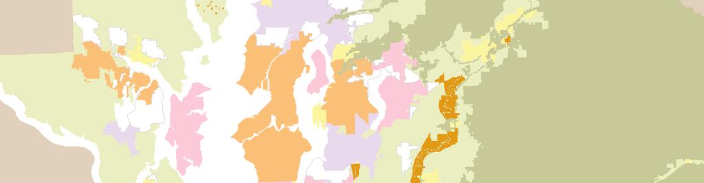
9 Exhibit 5-5. Existing Land Use
10 5-10 Land Use, Population, Employment, and Housing The transportation alternatives do vary in how they interact with this amount of forecast growth, as well as with existing land use and development regulations. Accessibility, development constraints, and household and employer location choices have the potential to yield different urban development patterns within UGAs, and consequently, the potential for marginal differences in overall regional urban form. 4 What effects on land use, population, employment, and housing are specific to individual alternatives? This analysis explores how closely each alternative supports a land use pattern that is consistent with the preferred population distribution in the VISION 2040 Regional Growth Strategy. For a regional scale of analysis, the primary intent was to determine whether the Baseline Alternative and action alternatives supported a fundamental premise of the Regional Growth Strategy: focusing the majority of the region s growth into currently designated urban areas, and within urban areas, into large urban cities and into designated regional centers. VISION 2040 identifies the importance of transportation in achieving the land use pattern envisioned in the Regional Growth Strategy. VISION 2040 also recognizes that transportation systems alone cannot be expected to produce the region s desired land use and development patterns. Finegrained changes to development regulations over time based on local circumstances, together with a variety of other economic incentives, will play equally critical roles. Subgroups of VISION 2040 Regional Growth Strategy Regional Geographies Used in the Transportation 2040 Analysis Urban Core Metropolitan Cities Core Cities Larger Cities Outlying Urban Small Cities Unincorporated Urban Growth Areas Rural Areas Modeled land use policy assumptions were developed to facilitate a comparative analysis to learn about the sensitivity of land uses to different transportation networks. Development constraints consistent with VISION 2040 land use policy direction were applied uniformly to regional geographies across the region within the UrbanSim land use model. The use of the region s land use model in this analysis is not intended to predict population and employment locations in small geographic areas, but to allow the land use model to react
11 Puget Sound Regional Council 5-11 to the transportation plan alternatives to see if resulting land use patterns are consistent with VISION 2040 at a regional scale. Land use assumptions were not developed to explicitly represent individual policies or land use actions that would be adopted at the local level. These will necessarily differ from more global assumptions used in this analysis. For a more detailed description of the representation of land use policy in Transportation 2040 modeling and analysis, refer to Appendix E. In the Baseline Alternative, 59 percent of regional population growth occurred in urban core geographies, somewhat less than Regional Growth Strategy guidance of 64 percent. Thirty-eight percent of growth occurred in outlying urban regional geographies, and 3 percent occurred in rural areas. This compares to Regional Growth Strategy guidance of 30 percent and 7 percent, respectively. While the modeled regional distribution of population growth from 2000 to 2040 does not exactly match the percentages contained in guidance provided by the Regional Growth Strategy, 97 percent of regional population growth and 98 percent of employment growth in the Baseline Alternative occurs within the designated UGA. Therefore, the Baseline Alternative does not appear to lead to disproportionate levels of population, housing, or employment growth outside the UGA. The draft action alternatives and the Preferred Alternative also do not appear to lead to disproportionate levels of population, housing, or employment growth outside the UGA. For all alternatives, population and employment growth concentrates overwhelmingly in the existing UGA. In this respect, regional growth in the Baseline Alternative and action alternatives is distributed in patterns highly consistent with the Regional Growth Strategy. All of the alternative transportation networks produced population distribution patterns that were generally consistent with the VISION 2040 Regional Growth Strategy. As illustrated in Exhibits 5-6 and 5-7, the modeled population distributions across regional geographies varied very little in
12 5-12 Land Use, Population, Employment, and Housing response to the differing transportation networks for the draft action alternatives and the Preferred Alternative. Exhibits 5-6 and 5-8 show that, similar to population, the employment distribution across regional geographies also varied little in response to the differing transportation networks for the Baseline Alternative, draft action alternatives, and the Preferred Alternative. Existing concentrations of employment exert a strong influence on the location choices of new firms and businesses, making dramatic differences in overall regional employment patterns unlikely. The Baseline Alternative resulted in a distribution of employment growth that was highly consistent with the guidance contained in the Regional Growth Strategy, which itself is similar to the distribution of existing employment concentrations. While the differences among the alternatives are slight, there are some observable differences in the distribution of employment across alternatives at the regional level. Compared to the Baseline Alternative, all draft action alternatives support slightly more employment growth in outlying urban and rural areas. The Preferred Alternative minimizes those differences and produces an employment pattern similar to the Baseline Alternative. Compared to the Baseline Alternative, Alternative 4 is the least supportive of employment growth in the urban core, and supports more growth in outlying urban areas than any other alternative. Alternatives 3 and 4 supported slightly more growth in rural areas than the Baseline Alternative. The Preferred Alternative produces slightly less employment growth in outlying areas. Despite these marginal differences, all of the alternative networks produced employment distribution patterns consistent with the VISION 2040 Regional Growth Strategy at the regional level.
13 Exhibit Population and Employment Growth in Regional Geographies (2040 Baseline Alternative and Change from Baseline Alternative) Puget Sound Regional Council 5-13 ( g ) POPULATION 2000 Baseline Alt 1 Alt 2 Alt 3 Alt 4 Alt 5 PA C PA Metro Cities 955,100 1,500,600 8,500 7,100 13,100 4,800 2,700 4,800 1,200 Core Cities 580, ,100 10, ,500 3,400 2,700 2,100 7,000 Larger Cities 326, ,100 2,300 3,300 2, , Small Cities 258, , ,900 3,300 1,400 3,500 3,500 4,500 Unic UGA 594,600 1,018, ,800 2,500 1,000 2,500 4, Rural 484, , , ,200 1,800 Urban Core 1,861,900 2,853, ,100 6,900 2,100 6,400 2,600 6,100 Outlying Urban 853,200 1,500, ,700 5,800 2,400 6,000 1,400 4,300 Rural 484, , , ,200 1,800 TOTAL 3,199,700 4,887, EMPLOYMENT 2000 Baseline Alt 1 Alt 2 Alt 3 Alt 4 Alt 5 PA C PA Metro Cities 924,000 1,526,300 13,100 18,000 14,500 4,200 11,300 9,900 17,700 Core Cities 521, ,200 15,300 28,100 16,200 19,300 14,500 4,800 16,800 Larger Cities 121, ,700 1,500 7,400 2,600 6,500 1,500 2,500 4,100 Small Cities 106, ,100 2,400 2,400 3,500 5,100 3,100 5,100 1,600 Unic UGA 118, ,600 3,200 5,100 3,100 11,200 3,000 3,000 4,700 Rural 65,000 93, ,000 1, ,200 1,400 Urban Core 1,566,000 2,541, , ,000 1,700 2,600 5,000 Outlying Urban 224, , , , ,100 3,100 Rural 65,000 93, ,000 1, ,200 1,400 TOTAL 1,855,000 3,055, , Source: PSRC 1 This exhibit has changed since the DEIS.
14 5-14 Land Use, Population, Employment, and Housing Exhibit Shares of Population Growth by Regional Geography and Alternative 35.0% RGS Baseline Alt 1 Alt 2 Alt 3 Alt 4 Alt 5 PA C PA F Percent Share of Regional Growth 30.0% 25.0% 20.0% 15.0% 10.0% 5.0% 0.0% Metro Cities Core Cities Larger Cities Small Cities Unic UGA Rural (RGS = VISION 2040 Regional Growth Strategy) Percent of Population Growth by Geography Growth Strategy Baseline Urban Core 64% 59% Outlying Urban 30% 38% Rural 7% 3% 2 This exhibit has changed since the DEIS.
15 Puget Sound Regional Council 5-15 Exhibit Shares of Employment Growth by Regional Geography and Alternative (RGS = VISION 2040 Regional Growth Strategy) RGS Baseline Alt 1 Alt 2 Alt 3 Alt 4 Alt 5 PA C PA F 60.0% 50.0% Percent Share of Regional Growth 40.0% 30.0% 20.0% 10.0% 0.0% Metro Cities Core Cities Larger Cities Small Cities Unic UGA Rural Percent of Employment Growth by Geography Growth Strategy Baseline Urban Core 80% 81% Outlying Urban 17% 16% Rural 3% 2% 3 This exhibit has changed since the DEIS.
16 5-16 Land Use, Population, Employment, and Housing 5 Which land use issues were considered in the analysis? Housing. Transportation 2040 is a non-project action and will not directly cause significant impacts or changes to the amount, quality, or characteristics of the region s housing stock. Balance of Jobs and Housing. The VISION 2040 Regional Growth Strategy seeks to improve the balance of job opportunities and available housing within each county, as compared to the regional jobs-population ratio. None of the transportation networks in the Baseline Alternative, draft action alternatives, or the Preferred Alternative seemed to influence the overall distribution patterns of employment and housing units among counties as measured by the ratio of jobs to housing units. Exhibit 5-9 depicts the regional jobs and housing balance information. Housing in the region would not be directly affected by the regional transportation plan. Source: Parametrix, Inc. Urban Land. The region s urbanized area is likely to become denser as an additional 1.5 million people populate the region by In compact development patterns, transit and nonmotorized transportation modes are often more competitive, convenient, and attractive. Rural Land. Both the Growth Management Act and regional policy generally prohibit the extension of urban levels of service into rural areas as stated in Revised Code of Washington (RCW) 36.70A.110 (4). Natural Resource Land. Transportation alternatives that interact with land use policy in a manner that minimizes development adjacent or proximate to these lands are likely to have less impact on water resources (refer to Chapter 9: Water Quality and Hydrology), ecosystem change (refer to Chapter 10: Ecosystems and Endangered Species Act Issues), or infrastructure impacts (refer to Chapter 14: Public Services and Utilities and Chapter 4: Transportation).
17 Puget Sound Regional Council 5-17 Exhibit Jobs Housing Balance (BL = Baseline) Jobs Housing Balance King County Jobs Housing Balance Kitsap County BL Alt 1 Alt 2 Alt 3 Alt 4 Alt 5 PA C PA BL Alt 1 Alt 2 Alt 3 Alt 4 Alt 5 PA C PA Jobs Housing Balance Pierce County Jobs Housing Balance Snohomish County BL Alt 1 Alt 2 Alt 3 Alt 4 Alt 5 PA C PA BL Alt 1 Alt 2 Alt 3 Alt 4 Alt 5 PA C PA 2040 Jobs to Housing Ratio BL Alt 1 Alt 2 Alt 3 Alt 4 Alt 5 PA C PA King Housing Units 1,208,300 1,206,000 1,212,300 1,205,800 1,216,300 1,216,200 1,211,000 1,208,900 Employment 1,979,600 1,962,000 1,973,200 1,967,300 1,954,200 1,979,100 1,961,900 1,964,600 Emp/HU Kitsap Housing Units 172, , , , , , , ,400 Employment 130, , , , , , , ,800 Emp/HU Pierce Housing Units 456, , , , , , , ,600 Employment 518, , , , , , , ,300 Emp/HU Snohomish Housing Units 438, , , , , , , ,200 Employment 427, , , , , , , ,500 Emp/HU Source: PSRC 4 This exhibit has changed since the DEIS.


18 5-18 Land Use, Population, Employment, and Housing Critical Areas. Similar to natural resource lands, growth close to critical areas can have environmental impacts and create pressure for conversion of these areas to other land use types. Alternatives that minimize development adjacent or proximate to critical areas are likely to have less impact on floodplains, steep slopes, and other environmentally sensitive areas such as wetlands and streams. Refer to Chapter 10: Ecosystems and Endangered Species Act Issues and Chapter 9: Water Quality and Hydrology for a more complete discussion of potential impacts to critical areas attributable to the alternatives. Population and Employment in Centers. As described above, the distribution of population and employment in all of the alternatives was consistent with the allocations in the adopted Regional Growth Strategy, with few appreciable differences among the alternatives. New roads should be designed to avoid critical areas. Source: Parametrix, Inc. At a finer grain, however, the Regional Growth Strategy identifies the desire to encourage both population and employment growth in designated regional growth centers in metropolitan and core cities. These areas are intended to attract residents and businesses because of their proximity to services and jobs, a variety of housing types, access to regional amenities, high quality transit service, and other advantages. MICs are intended to accommodate employment growth, but not housing or other uses. Any growth of population in the region s designated regional growth centers is desirable. Compared to 2006, the Baseline Alternative supported significant population growth of over 170,000 additional people in designated regional growth centers, highly supportive of the objectives of the Regional Growth Strategy. This represents an increase of 139 percent over the year While the observable differences between the Baseline Alternative and action alternatives are modest, particularly at a regional scale, Alternatives 3 and 4 supported slightly more population growth in regional growth centers than the Baseline Alternative, 5.1 percent and 4.3 percent, respectively. Alternatives 1 and 2 supported slightly less population growth in regional growth centers than the Baseline Alternative, -3.9 percent and -2.6 percent, respectively.
19 Puget Sound Regional Council 5-19 Alternative 5 is virtually identical to the Baseline Alternative. The Preferred Alternative demonstrated some of the strongest support for growth in centers, ranging between 3 percent and 6 percent more population growth in centers than the Baseline Alternative (refer to Exhibit 5-10). Any employment growth in the region s designated regional growth centers is desirable, particularly in centers located in core cities. Compared to 2006, the Baseline Alternative supported significant employment growth of over 475,000 jobs in designated regional growth centers, an increase of 83 percent over 2006 levels. This growth is highly supportive of the Regional Growth Strategy objectives. As with population, the observable differences in employment growth across the alternatives are relatively modest. Alternatives 3 and 4 support less employment growth in regional growth centers, -3.5 percent and -7.8 percent, respectively. Alternatives 1 and 5 seem to be more supportive of employment growth in designated regional growth centers than the Baseline Alternative, with little to no change in Alternative 2. Alternatives 3 and 4, however, produce notable decreases in employment in regional growth centers (nearly 17,000 fewer jobs in Alternative 3 and over 37,000 fewer jobs in Alternative 4) compared to the Baseline Alternative. Similar to Alternatives 3 and 4, the Preferred Alternative is less supportive of employment growth in designated regional growth centers than the Baseline Alternative, producing a range of between -7 percent fewer jobs in the constrained plan (approximately 35,000) and 1 percent more jobs in the full plan (approximately 3,900). Refer to Exhibit 5-10 for more information.
20 5-20 Land Use, Population, Employment, and Housing Exhibit Population and Employment in Regional Growth Centers (RGCs) and Manufacturing Industrial Centers (MICs) Population and Employment Growth in Regional Centers (2040 Baseline and Change from Baseline) Alternative 2000 Baseline Alt 1 Alt 2 Alt 3 Alt 4 Alt 5 PA C PA Population in Regional Growth Centers 122, ,400 6,600 4,500 8,600 7, ,000 10,100 Employment in Regional Growth Centers 573,600 1,049,900 12,600 1,600 16,900 37,400 6,900 34,600 3,900 Employment in Man/Ind Centers 172, , ,700 4, ,200 4,400 Source: PSRC 4.0% Alt 1 Alt 2 Alt 3 Alt 4 Alt 5 PA C PA Change from Baseline 3.0% 2.0% 1.0% 0.0% 1.0% 2.0% 3.0% 4.0% Population in RGC Employment in RGC Employment in MIC 5 This exhibit has changed since the DEIS.
21 Puget Sound Regional Council 5-21 The VISION 2040 Regional Growth Strategy also seeks to bolster the region s designated MICs. Any employment growth in the region s designated MICs is desirable. Compared to 2006, the Baseline Alternative supported significant employment growth over 22,000 jobs in designated MICs, highly supportive of the Regional Growth Strategy objectives. All alternatives appear to support sustained employment in the region s MICs. Alternatives 1, 2, and 5 showed little variation in employment growth in MICs from the Baseline Alternative. Alternatives 3 and 4 appear to be more supportive of employment growth in MICs compared to the Baseline Alternative, increasing growth 16.1 percent and 20.7 percent, respectively. The Preferred Alternative demonstrated a range of support between 10 percent more and -19 percent fewer jobs compared to the Baseline Alternative. Refer to Exhibit 5-10 for more information. 6 What cumulative effects could occur if the Transportation 2040 actions coincide with other planned actions? Future cumulative effects on land use, population, employment, and housing could be affected by other regional plans and actions. Local jurisdictions throughout the region will revise their existing land use plans to be consistent with VISION 2040 and complement the Transportation 2040 Preferred Alternative. New development resulting from these plans could have both positive and negative effects on the environment. What are cumulative effects? Cumulative effects address the impact on the environment, which results from the incremental impact of the action when added to other past, present, and reasonably foreseeable future actions, regardless of what agency or person undertakes such other actions. Cumulative impacts can result from individually minor but collectively significant actions taking place over a period of time. As described in this chapter, PSRC has performed an analysis of the development pattern changes that could result from the transportation alternatives and has concluded that none of the action alternatives would lead to future land use and development pattern changes that are substantively different than the Baseline Alternative. In addition, all of the draft Transportation 2040 alternatives and the Preferred Alternative are consistent with the adopted VISION 2040 Regional Growth Strategy. Therefore, none of the Transportation 2040 alternatives would result in additional cumulative effects on
22 5-22 Land Use, Population, Employment, and Housing land use, population, employment, and housing beyond those identified in the VISION 2040 Environmental Impact Statement. 7 What can be done to mitigate the effects of transportation projects upon the region s land uses? As individual projects are developed, project sponsors would design specific measures to mitigate impacts from transportation projects on land use. At the local level, jurisdictions with land use and planning responsibilities would identify discrete actions to mitigate the direct impacts of urbanization. However, general strategies that could be pursued to address land use issues which include impacts to people, job locations, and housing include the following: Strategies for urban lands Plan high-capacity transit networks to serve existing and planned concentrations of housing and employment. Provide for high-density, mixed-use development adjacent to high-capacity transit stations. Compile and disseminate information including model planning policies, regulations, and guidelines to facilitate planning for future high-capacity transit station areas. Prioritize phasing of transportation investments to centers and other areas expected to accommodate a large share of planned growth. Work with local jurisdictions to discuss and develop strategies for phasing growth, using centers and transportation improvements to determine the location and timing of growth. Incorporate context-sensitive design practices into planning and development of transportation projects to ensure facilities are compatible with existing development and the surrounding environment. Site schools and other institutions in locations where they are accessible from multiple transportation modes.
23 Puget Sound Regional Council 5-23 Design complete streets to accommodate a wide variety of users. Design green streets to minimize environmental impacts from roadways. Avoid developing disconnected street networks. Complete the grid to improve connectivity. Strategies for rural and natural resource lands Design facilities and infrastructure according to rural standards that neither negatively affect rural character nor provide new opportunities for increased development in rural areas or on natural resource lands. Establish access controls to facilities traversing or close to rural and natural resource lands. Increase development densities or clustering in existing rural cities, towns, and hamlets to help reduce the conversion of rural land. This may also be effective for reducing the loss of farmland. In addition, this could create more centralized areas of employment to reduce longer-distance commuting and potentially make more jobs accessible by transit. 8 Are there any significant unavoidable adverse impacts? The update of the plan is intended to support and enhance implementation of local comprehensive plans and achievement of the VISION 2040 Regional Growth Strategy. Indirect impacts would result from the general location of future growth and the incremental change in the relative concentration or dispersion of the future regional land use growth. The transportation system that is developed will influence the development of individual land parcels, which will have environmental impacts. Depending on the opportunities for transit-oriented development associated with some alternatives, additional planning for growth will be required in some of the region s jurisdictions. Significant unavoidable adverse impacts could occur and would vary among the alternatives. Adopted plans, policies, and regulations might need to change to accommodate any of
24 5-24 Land Use, Population, Employment, and Housing the future alternatives as particular transportation facilities are developed. Local jurisdictions would determine the actual permitted densities and types of land uses appropriate for different levels of transportation service. Urban Land. Enhanced transportation facilities and services would help to enable local jurisdictions to accommodate future growth in existing urbanized areas. Existing urban areas are likely to become more compact in nature and will be served by a greater variety of transportation choices. Rural Land. Counties might need to adopt policies designed to direct new development in unincorporated areas near existing city boundaries or within city spheres of influence. This would include implementation of tools to minimize rural development impacts, particularly in proximity to transportation projects that provide additional capacity and are adjacent to or traverse rural areas. Natural Resource Land. Transportation projects near designated natural resource areas would provide greater accessibility. This could create pressure for conversion of these lands to other land use types, making it important to implement tools to keep these lands economically viable.
DefinitionofAlternatives
 4. DefinitionofAlternatives After approximately two years of outreach and public input, PSRC has identified four alternatives for evaluation in this Draft Environmental Impact Statement: Growth Targets
2013 Land Use Baseline Validation Report: Maintenance Release 1 (MR1) Update
 Update") 2013 Land Use Baseline Validation Report: Maintenance Release 1 (MR1) Update April 2014 Introduction The purpose of model validation is to compare the performance of a model system or its components to
2013 Land Use Baseline Validation Report: Maintenance Release 1 (MR1) Update April 2014 Introduction The purpose of model validation is to compare the performance of a model system or its components to
Regional Growth Strategy Work Session Growth Management Policy Board
 Regional Growth Strategy Work Session Growth Management Policy Board September 6, 2018 1 Overview Recap June GMPB work session Objectives and outcomes Regional geographies Growth scenarios Breakout Discussion:
Regional Growth Strategy Regional TOD Advisory Committee
 Regional Strategy Regional TOD Advisory Committee September 21, 2018 Overview Regional Geographies Transit-Oriented Development Goal Scenarios Next Steps 2 Schedule + Process September 6 Management Policy
Kitsap County 2016 Comprehensive Plan Update. Appendix A: Growth Estimates
 Kitsap County 2016 Comprehensive Plan Update Appendix A: Growth Estimates Appendix A 1 April 2016 Kitsap County 2016 Comprehensive Plan Update Appendix A: Growth Estimates Land Capacity Land capacity
Fireworks Ban or Restricted Sales/Use. State Fireworks Law RCW
 Fireworks Ban or Sales/Use Fireworks Ban or Sales/Use by County and City RCW 70.77.395 State Law Fireworks sales and discharge laws. Dates and times common fireworks may be sold or discharged. State Fireworks
Chapter 12 Earth. 1 What are the characteristics of the region s physical setting and geology?
 Chapter 12 Earth 1 What are the characteristics of the region s physical setting and geology? The physical form and geology of the central Puget Sound region has been shaped over millions of years by three
VISION 2040 people prosperity planet. Puget Sound Regional Council
 VISION 2040 people prosperity planet Puget Sound Regional Council PSRC December 2009 EXECUTIVE BOARD (as of VISION 2040 adoption April 24, 2008) Mayor Pro Tem Sue Singer, City of Auburn, Other Cities in
HORIZON 2030: Land Use & Transportation November 2005
 PROJECTS Land Use An important component of the Horizon transportation planning process involved reviewing the area s comprehensive land use plans to ensure consistency between them and the longrange transportation
Economic Activity Economic A ctivity
 5 Economic Economic Activity Activity ECONOMIC ACTIVITY 5.1 EMPLOYMENT... 5-7 5.1.1 OBJECTIVE... 5-7 5.1.2 POLICIES... 5-7 5.2 PROTECTING THE AREA OF EMPLOYMENT... 5-9 5.2.1 OBJECTIVE... 5-9 5.2.2 POLICIES...
WASHINGTON DECA COMPETITIVE EVENT ALLOCATIONS 5:08 P.M.
 Area Students Advisors Alumni Professional Total Members Percentage of Total Members for: Individual Series and Team Decision Making 70 Total Rounded Up Min 2 for: EIP, ESB, ADC, FMP, SEPP, FCE, HTPS,
Washington DECA Voting Delegates
 2017-2018 Chapters earn one voting delegate for every 18 members registered by 5:00 p.m. November 15. If a chapter did not have any registered members at that time, the chapter has 0 voting delegates.
Date: June 19, 2013 Meeting Date: July 5, Consideration of the City of Vancouver s Regional Context Statement
 Section E 1.5 To: From: Regional Planning and Agriculture Committee Lee-Ann Garnett, Senior Regional Planner Planning, Policy and Environment Department Date: June 19, 2013 Meeting Date: July 5, 2013 Subject:
Forecasts for the Reston/Dulles Rail Corridor and Route 28 Corridor 2010 to 2050
 George Mason University Center for Regional Analysis Forecasts for the Reston/Dulles Rail Corridor and Route 28 Corridor 21 to 25 Prepared for the Fairfax County Department of Planning and Zoning Lisa
Regional Transit Development Plan Strategic Corridors Analysis. Employment Access and Commuting Patterns Analysis. (Draft)
") Regional Transit Development Plan Strategic Corridors Analysis Employment Access and Commuting Patterns Analysis (Draft) April 2010 Contents 1.0 INTRODUCTION... 4 1.1 Overview and Data Sources... 4 1.2
Regional Transit Development Plan Strategic Corridors Analysis Employment Access and Commuting Patterns Analysis (Draft) April 2010 Contents 1.0 INTRODUCTION... 4 1.1 Overview and Data Sources... 4 1.2
CERTIFIED RESOLUTION. introduction: and dated May 29, 2017, as attached, as appropriate
 15322 Buena Vista Avenue, White Rock BC, Canada V4B 1Y6 www.whiterockcity.ca City of White Rock P: 604.541.22121 F: 604.541.9348 /2tC% City Clerk s Office IT E ROC K June 13,2017 Stephanie Lam, Deputy
Local Area Key Issues Paper No. 13: Southern Hinterland townships growth opportunities
 Draft Sunshine Coast Planning Scheme Review of Submissions Local Area Key Issues Paper No. 13: Southern Hinterland townships growth opportunities Key Issue: Growth opportunities for Southern Hinterland
Regional Growth Strategy Regional Staff Committee
 Regional Growth Strategy Regional Staff Committee June 21, 2018 1 Overview Summary of June Growth Management Policy Board Regional Growth Strategy Objectives Regional Geographies Regional Growth Strategy
King City URA 6D Concept Plan
 King City URA 6D Concept Plan King City s Evolution Among the fastest growing cities 2000 Census 1,949 2010 Census 3,111 60% increase 2016 Census estimate 3,817 23% increase Average annual rate 4.3% Surpassing
MPOs SB 375 LAFCOs SCAG Practices/Experiences And Future Collaborations with LAFCOs
 Connecting LAFCOs and COGs for Mutual Benefits MPOs SB 375 LAFCOs SCAG Practices/Experiences And Future Collaborations with LAFCOs Frank Wen, Manager Research & Analysis Land Use & Environmental Planning
The 3V Approach. Transforming the Urban Space through Transit Oriented Development. Gerald Ollivier Transport Cluster Leader World Bank Hub Singapore
 Transforming the Urban Space through Transit Oriented Development The 3V Approach Gerald Ollivier Transport Cluster Leader World Bank Hub Singapore MDTF on Sustainable Urbanization The China-World Bank
Proposed Scope of Work Village of Farmingdale Downtown Farmingdale BOA Step 2 BOA Nomination Study / Draft Generic Environmental Impact Statement
 Proposed Scope of Work Village of Farmingdale Downtown Farmingdale BOA Step 2 BOA Nomination Study / Draft Generic Environmental Impact Statement The scope of work that follows incorporates and covers
Environmental Analysis, Chapter 4 Consequences, and Mitigation
 Environmental Analysis, Chapter 4 4.17 Environmental Justice This section summarizes the potential impacts described in Chapter 3, Transportation Impacts and Mitigation, and other sections of Chapter 4,
Public Transportation Infrastructure Study (PTIS) - 2 nd Technical Advisory Committee Meeting
 - 2 nd Technical Advisory Committee Meeting") Public Transportation Infrastructure Study (PTIS) - 2 nd Technical Advisory Committee Meeting Presentation to: Technical Advisory Committee (TAC) Presented by: and Team July 8th, 2009 Public Transportation
Public Transportation Infrastructure Study (PTIS) - 2 nd Technical Advisory Committee Meeting Presentation to: Technical Advisory Committee (TAC) Presented by: and Team July 8th, 2009 Public Transportation
The Governance of Land Use
 The planning system The Governance of Land Use United Kingdom Levels of government and their responsibilities The United Kingdom is a unitary state with three devolved governments in Northern Ireland,
CLAREMONT MASTER PLAN 2017: LAND USE COMMUNITY INPUT
 Planning and Development Department 14 North Street Claremont, New Hampshire 03743 Ph: (603) 542-7008 Fax: (603) 542-7033 Email: cityplanner@claremontnh.com www.claremontnh.com CLAREMONT MASTER PLAN 2017:
Aggregating Local GIS Inquiry for Regional Perspectives
 Aggregating Local GIS Inquiry for Regional Perspectives RYAN ULSBERGER CENTER FOR URBAN WATERS PUGET SOUND INSTITUTE SEPTEMBER 13, 2012 Acknowledgements I would like to thank the donors to the UWT Urban
Joint Planning Advisory Council July 19, 2011
 Joint Planning Advisory Council July 19, 2011 Global Cities Program Objectives Helping advance strategic thinking in a variety of critical areas. Facilitating informed decisionmaking on the part of public
CORPORATION OF THE CITY OF COURTENAY COUNCIL MEETING AGENDA
 CORPORATION OF THE CITY OF COURTENAY COUNCIL MEETING AGENDA DATE: Monday, January 14, 2013 PLACE: City Hall Council Chambers TIME: 4:00 p.m. 1.00 ADOPTION OF MINUTES 1. Adopt January 7, 2013 Regular Council
Subject: Note on spatial issues in Urban South Africa From: Alain Bertaud Date: Oct 7, A. Spatial issues
 Page 1 of 6 Subject: Note on spatial issues in Urban South Africa From: Alain Bertaud Date: Oct 7, 2009 A. Spatial issues 1. Spatial issues and the South African economy Spatial concentration of economic
CHAPTER 4 HIGH LEVEL SPATIAL DEVELOPMENT FRAMEWORK (SDF) Page 95
 Page 95") CHAPTER 4 HIGH LEVEL SPATIAL DEVELOPMENT FRAMEWORK (SDF) Page 95 CHAPTER 4 HIGH LEVEL SPATIAL DEVELOPMENT FRAMEWORK 4.1 INTRODUCTION This chapter provides a high level overview of George Municipality s
CHAPTER 4 HIGH LEVEL SPATIAL DEVELOPMENT FRAMEWORK (SDF) Page 95 CHAPTER 4 HIGH LEVEL SPATIAL DEVELOPMENT FRAMEWORK 4.1 INTRODUCTION This chapter provides a high level overview of George Municipality s
Regional Snapshot Series: Transportation and Transit. Commuting and Places of Work in the Fraser Valley Regional District
 Regional Snapshot Series: Transportation and Transit Commuting and Places of Work in the Fraser Valley Regional District TABLE OF CONTENTS Complete Communities Daily Trips Live/Work Ratio Commuting Local
King County GIS Center 2018 Esri User Conference San Diego, California July 12, 2018
 Greg Babinski, MA, GISP Marketing & Business Development Manager URISA Past-President King County GIS Center 2018 Esri User Conference San Diego, California July 12, 2018 Geography has always been a major
A Method for Mapping Settlement Area Boundaries in the Greater Golden Horseshoe
 A Method for Mapping Settlement Area Boundaries in the Greater Golden Horseshoe Purpose This paper describes a method for mapping and measuring the lands designated for growth and urban expansion in the
The CRP stresses a number of factors that point to both our changing demographics and our future opportunities with recommendations for:
 Plan Overview The CRP represents the first broad planning initiative covering Lake, Porter and LaPorte counties. Unlike previous plans released by NIRPC, which focused primarily on transportation, the
III. FORECASTED GROWTH
 III. FORECASTED GROWTH In order to properly identify potential improvement projects that will be required for the transportation system in Milliken, it is important to first understand the nature and volume
Introduction and Project Overview
 Greater New Orleans Regional Land Use Modeling GIS Techniques in a P olitical C ontext Louisiana Remote Sensing and GIS Workshop Wednesday, April 24, 2013 Working Towards a Shared Regional Vision Introduction
Rural Pennsylvania: Where Is It Anyway? A Compendium of the Definitions of Rural and Rationale for Their Use
 Rural Pennsylvania: Where Is It Anyway? A Compendium of the Definitions of Rural and Rationale for Their Use Pennsylvania Office of Rural Health 310 Nursing Sciences Building University Park, PA 16802
Population and Employment Forecast
 Population and Employment Forecast How Do We Get the Numbers? Thurston Regional Planning Council Technical Brief Updated July 2012 We plan for forecast growth in Population and Employment, but where do
Study Overview. the nassau hub study. The Nassau Hub
 Livable Communities through Sustainable Transportation the nassau hub study AlternativeS analysis / environmental impact statement The Nassau Hub Study Overview Nassau County has initiated the preparation
City of Chino Hills General Plan Update 13GPA02 Scoping Meeting. June 4, 2013
 13GPA02 Scoping Meeting June 4, 2013 Every California city must adopt a comprehensive, long-term general plan. The General Plan is the City s constitution or blueprint for its long-range physical development.
GIS in Community & Regional Planning
 GIS in Community & Regional Planning The The role role of of GIS GIS in in Re-writing the the Zoning Bylaw for for the the City City of of Vernon LandInfo Technologies Presentation Overview The GIS Initiative
Regional Performance Measures
 G Performance Measures Regional Performance Measures Introduction This appendix highlights the performance of the MTP/SCS for 2035. The performance of the Revenue Constrained network also is compared to
The Role of Transitways in Our Region s Economic Competitiveness. The 23rd CTS Annual Research Conference St. Paul, MN May 23, 2012
 The Role of Transitways in Our Region s Economic Competitiveness The 23rd CTS Annual Research Conference St. Paul, MN May 23, 2012 1 2 Twin Cities Competitive Clusters 3 Competitive Clusters interconnected
APPENDIX I - AREA PLANS
 ROUTE 37 WEST LAND USE PLAN ROUTE 37 WEST LAND USE PLAN Recent land use decisions and development trends have drawn attention to the land within the Route 37 western by-pass area between Route 50 and
Volume Title: Empirical Models of Urban Land Use: Suggestions on Research Objectives and Organization. Volume URL:
 This PDF is a selection from an out-of-print volume from the National Bureau of Economic Research Volume Title: Empirical Models of Urban Land Use: Suggestions on Research Objectives and Organization Volume
3.0 ANALYSIS OF FUTURE TRANSPORTATION NEEDS
 3.0 ANALYSIS OF FUTURE TRANSPORTATION NEEDS In order to better determine future roadway expansion and connectivity needs, future population growth and land development patterns were analyzed as part of
TREASURE COAST REGIONAL PLANNING COUNCIL M E M O R A N D U M. To: Council Members AGENDA ITEM 4B10
 TREASURE COAST REGIONAL PLANNING COUNCIL M E M O R A N D U M To: Council Members AGENDA ITEM 4B10 From: Date: Subject: Staff December 14, 2018 Council Meeting Local Government Comprehensive Plan Review
State initiative following up the 2006 national planning report
 18 ness districts and public institutions, should be integrated with the opportunities for public transport services. State initiative following up the 2006 national planning report The Ministry of the
Alternatives Analysis
 Alternatives Analysis Prepared for: Metropolitan Atlanta Rapid Transit Authority Prepared by: AECOM/Jacobs-JJG Joint Venture Atlanta, GA November 2012 Page Left Intentionally Blank ii TABLE OF CONTENTS
TABLE OF CONTENTS ARTICLE I. POLK COUNTY COMPREHENSIVE PLAN VOLUME 1. Page CHAPTER 1. GENERAL... A-1
 TABLE OF CONTENTS ARTICLE I. POLK COUNTY COMPREHENSIVE PLAN VOLUME 1 Page CHAPTER 1. GENERAL... A-1 DIVISION 1.100 GENERAL PROVISIONS... A-1 DIVISION 1.200 BASIC PRINCIPLES... A-6 DIVISION 1.300 THE PLANNING
Port Cities Conference: How Regional Planning can Help Support a Competitive Port. Christina DeMarco Metro Vancouver
 Port Cities Conference: How Regional Planning can Help Support a Competitive Port Christina DeMarco Metro Vancouver June 12. 2008 Metro Vancouver Regional Growth Management Three ways to help support the
Wasatch Front Region Small Area Socioeconomic Forecasts: Technical Report #49
 Regional Transportation Plan: 2011-2040 Appendix A APPENDIX A Wasatch Front Region Small Area Socioeconomic Forecasts: 2007-2040 Technical Report #49 July, 2010 295 N. Jimmy Doolittle Road Salt Lake City,
Regional Performance Measures
 G Performance Measures Regional Performance Measures Introduction This appendix highlights the performance of the MTP/SCS for 2035. The performance of the Revenue Constrained network also is compared to
Wasatch Front Region Small Area Socioeconomic Forecasts: Technical Report #49
 Wasatch Front Region Small Area Socioeconomic Forecasts: 2007-2040 Technical Report #49 July, 2010 Wasatch Front Regional Council 295 N. Jimmy Doolittle Road Salt Lake City, UT 84116 P (801) 363-4250 F
An online data and consulting resource of THE UNIVERSITY OF TOLEDO THE JACK FORD URBAN AFFAIRS CENTER
 An online data and consulting resource of THE JACK FORD URBAN AFFAIRS CENTER THE CENTER FOR GEOGRAPHIC INFORMATION SCIENCE AND APPLIED GEOGRAPHICS DEPARTMENT OF GEOGRAPHY AND PLANNING THE UNIVERSITY OF
Too Close for Comfort
 Too Close for Comfort Overview South Carolina consists of urban, suburban, and rural communities. Students will utilize maps to label and describe the different land use classifications. Connection to
Portland s regional economy is integrated
 Periodic Atlas of the Regional Connections 2: Economy by Jeremy Young, Sheila Martin, and Meg Merrick; Cartography by Robert Smith, Jeremy Young, and Meg Merrick s regional economy is integrated across
Dark Sky Initiative Draft Terms of Reference
 Dark Sky Initiative Draft Terms of Reference July 2008 Table of Contents 1.0 Introduction 2 2.0 Initiative intent 2-3 3.0 Initiative goals 3 4.0 Legislation 3 5.0 Municipal Development Plan 3 6.0 Land
Tourism. April State Planning Policy state interest guideline. Department of Infrastructure, Local Government and Planning
 Department of Infrastructure, Local Government and Planning State Planning Policy state interest guideline Tourism April 2016 Great state. Great opportunity. Preface Using this state interest guideline
submission to plan melbourne
 submission to plan melbourne prepared by hansen partnership pty ltd december 2013 submission to plan melbourne hansen partnership pty ltd contents 1 introduction... 2 2 key issues facing melbourne...
Draft. Butte County Long-Term Regional Growth Forecasts
 Draft Butte County Long-Term Regional Growth Forecasts 2014 2040 Prepared by: November 25 th, 2014 2580 Sierra Sunrise Terrace, Suite 100 Chico, CA 95928 Phone: 530-879-2468 FAX: 530-879-244 www.bcag.org
CITY OF PAPILLION PLANNING COMMISSION STAFF REPORT MAY 27, 2015 AGENDA 2015 ANNEXATION MISC
 PLANNING COMMISSION STAFF REPORT MAY 27, 2015 AGENDA 2015 ANNEXATION MISC-15-0005 I. GENERAL INFORMATION A. APPLICANT: City of Papillion 122 East Third St. Papillion, NE 68046 B. LEGAL DESCRIPTION: See
 BPC Policy No , IIM7fyilK Office of the District Clerk TRANSITION ZONE POLICY")
TOD Priority Tool Executive Summary
 TOD Priority Tool Executive Summary A Resource for Identifying TOD Opportunities to Support High-Capacity Transit Capital Metropolitan Transportation Authority Austin, Texas 3 TOD PRIORITY TOOL THE TOD
3D - Boulder Valley Comprehensive Plan. Lesli Ellis Comprehensive Planning Manager City of Boulder
 3D - Boulder Valley Comprehensive Plan Lesli Ellis Comprehensive Planning Manager City of Boulder Presentation Boulder s use of 3D GIS and other tools in Comprehensive Planning (e.g., story maps, CityEngine,
GROWTH MANAGEMENT REPORT Wiarton South Settlement Area
 GROWTH MANAGEMENT REPORT Wiarton South Settlement Area Designations in the Town of Wiarton Prepared for: The Municipality of South Bruce Peninsula P.O. Box 310 315 George St. Wiarton, ON N0H 2T0 Prepared
Date: March 31, 2014 PATE; fyril 2.3,2 >H
 aj BRAMPTON fifs Rower City XH-l-f r.t "»* City Council The Corporation of the City of Brampton SRAMPTON CITY COUNCIL Date: March 31, 2014 PATE; fyril 2.3,2 >H File: POO GR VisWhtoJed ^t'th-meeh'^a Subject:
Population Trends Along the Coastal United States:
 Coastal Trends Report Series Population Trends Along the Coastal United States: 1980-2008 U.S. Department of Commerce National Oceanic and Atmospheric Administration National Ocean Service Assessing the
APPENDIX I: Traffic Forecasting Model and Assumptions
 APPENDIX I: Traffic Forecasting Model and Assumptions Appendix I reports on the assumptions and traffic model specifications that were developed to support the Reaffirmation of the 2040 Long Range Plan.
GIS Analysis of Crenshaw/LAX Line
 PDD 631 Geographic Information Systems for Public Policy, Planning & Development GIS Analysis of Crenshaw/LAX Line Biying Zhao 6679361256 Professor Barry Waite and Bonnie Shrewsbury May 12 th, 2015 Introduction
New Partners for Smart Growth: Building Safe, Healthy, and Livable Communities Mayor Jay Williams, Youngstown OH
 New Partners for Smart Growth: Building Safe, Healthy, and Livable Communities Mayor Jay Williams, Youngstown OH The City of Youngstown Youngstown State University Urban Strategies Inc. Youngstown needed
Figure 8.2a Variation of suburban character, transit access and pedestrian accessibility by TAZ label in the study area
 Figure 8.2a Variation of suburban character, transit access and pedestrian accessibility by TAZ label in the study area Figure 8.2b Variation of suburban character, commercial residential balance and mix
California Urban Infill Trip Generation Study. Jim Daisa, P.E.
 California Urban Infill Trip Generation Study Jim Daisa, P.E. What We Did in the Study Develop trip generation rates for land uses in urban areas of California Establish a California urban land use trip
Riocan Centre Study Area Frontenac Mall Study Area Kingston Centre Study Area
 OVERVIEW the biggest challenge of the next century (Dunham Jones, 2011). New books are continually adding methods and case studies to a growing body of literature focused on tackling this massive task.
CORRIDORS OF FREEDOM Access Management (Ability) Herman Pienaar: Director City Transformation and Spatial Planning
 Herman Pienaar: Director City Transformation and Spatial Planning") CORRIDORS OF FREEDOM Access Management (Ability) 2016 Herman Pienaar: Director City Transformation and Spatial Planning PLANNING DEVELOPMENT PROCESS RATHER THAN A PLAN CAPITAL INVESTMENT DEVELOPMENT FACILITATION
CORRIDORS OF FREEDOM Access Management (Ability) 2016 Herman Pienaar: Director City Transformation and Spatial Planning PLANNING DEVELOPMENT PROCESS RATHER THAN A PLAN CAPITAL INVESTMENT DEVELOPMENT FACILITATION
Regional Economic Competitiveness Local Comprehensive Planning. An End-of-year Update to the Metropolitan Council Community Development Committee
 Regional Economic Competitiveness Local Comprehensive Planning An End-of-year Update to the Metropolitan Council Community Development Committee 12/21/2015 Regional Economic Competitiveness The ability
Growth Management: Analysis of Comments Received and Responses Comments received as of October 16, 2017
 Growth Management: Analysis of Comments Received and s Comments received as of October 16, Comments informing the Region of Peel s growth management work have been summarized with responses below. These
A tale of two cities. John Daley, CEO, Grattan Institute Work and life in cities: City strategy in Australia Melbourne Economic Forum 27 October 2016
 A tale of two cities John Daley, CEO, Grattan Institute Work and life in cities: City strategy in Australia Melbourne Economic Forum 27 October 2016 A tale of two cities Shifts in consumption are driving
Committee Meeting November 6, 2018
 Committee Meeting November 6, 2018 Agenda Where we are in the process Land Use Plan Transportation Element Housing & Neighborhoods Elements Next Steps Schedule November 6: Plan Elements December: Plan
Chapter 3. Planning Constraints & Boundaries
 Chapter 3 Planning Constraints & Boundaries Table of Contents Page A. Introduction...3-1 B. Purpose and Authority...3-6 C. The Rio Vista Principles: Implementing the Community Vision...3-9 D. Setting...3-10
MULTIPLE CHOICE. Choose the one alternative that best completes the statement or answers the question.
 AP Test 13 Review Name MULTIPLE CHOICE. Choose the one alternative that best completes the statement or answers the question. 1) Compared to the United States, poor families in European cities are more
Managing Growth: Integrating Land Use & Transportation Planning
 Managing Growth: Integrating Land Use & Transportation Planning Metro Vancouver Sustainability Community Breakfast Andrew Curran Manager, Strategy June 12, 2013 2 Integrating Land Use & Transportation
Ecological Land Cover Classification For a Natural Resources Inventory in the Kansas City Region, USA
 Ecological Land Cover Classification For a Natural Resources Inventory in the Kansas City Region, USA by Applied Ecological Services, Inc. In cooperation with the Mid-America Regional Council 600 Broadway,
Flood Hazard Zone Modeling for Regulation Development
 Flood Hazard Zone Modeling for Regulation Development By Greg Lang and Jared Erickson Pierce County GIS June 2003 Abstract The desire to blend current digital information with government permitting procedures,
TRAVEL DEMAND MODEL. Chapter 6
 Chapter 6 TRAVEL DEMAND MODEL As a component of the Teller County Transportation Plan development, a computerized travel demand model was developed. The model was utilized for development of the Transportation
TOWARDS STRATEGIC SPATIAL PLANNING IN JAMAICA: THE NATIONAL SPATIAL PLAN
 TOWARDS STRATEGIC SPATIAL PLANNING IN JAMAICA: THE NATIONAL SPATIAL PLAN JIEP 5th Biennial Conference on the Environment: Balancing National Development and Environmental Protection June 6, 2011 Jamaica
Local Economic Activity Around Rapid Transit Stations
 Local Economic Activity Around Rapid Transit Stations The Case of Chicago s Orange Line Julie Cooper, MPP 2014 Harris School of Public Policy Transport Chicago June 6, 2014 Motivation Impacts of transit
Problems In Large Cities
 Chapter 11 Problems In Large Cities Create a list of at least 10 problems that exist in large cities. Consider problems that you have read about in this and other chapters and/or experienced yourself.
Your web browser (Safari 7) is out of date. For more security, comfort and the best experience on this site: Update your browser Ignore
 is out of date. For more security, comfort and the best experience on this site: Update your browser Ignore") Your web browser (Safari 7) is out of date. For more security, comfort and the best experience on this site: Update your browser Ignore urban area For the complete encyclopedic entry with media resources,
Your web browser (Safari 7) is out of date. For more security, comfort and the best experience on this site: Update your browser Ignore urban area For the complete encyclopedic entry with media resources,
Dimantha I De Silva (corresponding), HBA Specto Incorporated
, HBA Specto Incorporated") Paper Author (s) Dimantha I De Silva (corresponding), HBA Specto Incorporated (dds@hbaspecto.com) Daniel Flyte, San Diego Association of Governments (SANDAG) (Daniel.Flyte@sandag.org) Matthew Keating,
Paper Author (s) Dimantha I De Silva (corresponding), HBA Specto Incorporated (dds@hbaspecto.com) Daniel Flyte, San Diego Association of Governments (SANDAG) (Daniel.Flyte@sandag.org) Matthew Keating,
BROADBAND DEMAND AGGREGATION: PLANNING BROADBAND IN RURAL NORTHERN CALIFORNIA
 BROADBAND DEMAND AGGREGATION: PLANNING BROADBAND IN RURAL NORTHERN CALIFORNIA Steven J. Steinberg, Ph.D a,b, *, Rebecca Degagne a, M.S., Michael Gough a a Institute for Spatial Analysis, Humboldt State
Cultural Data in Planning and Economic Development. Chris Dwyer, RMC Research Sponsor: Rockefeller Foundation
 Cultural Data in Planning and Economic Development Chris Dwyer, RMC Research Sponsor: Rockefeller Foundation A Decade of Attempts to Quantify Arts and Culture Economic impact studies Community indicators
Urban White Paper on Tokyo Metropolis 2002
 Urban White Paper on Tokyo Metropolis 2002 By Bureau of City Planning Tokyo Metropolitan Government Part I. "Progress in IT and City Building" Effects of computer networks on cities and cities' response
Summary and Implications for Policy
 Summary and Implications for Policy 1 Introduction This is the report on a background study for the National Spatial Strategy (NSS) regarding the Irish Rural Structure. The main objective of the study
Knowledge claims in planning documents on land use and transport infrastructure impacts
 Knowledge claims in planning documents on land use and transport infrastructure impacts Presentation at the Final Workshop of the research project "Innovations for sustainable public transport in Nordic
Los Alamos Planning Advisory Committee. Stephen Peterson March 19, 2007
 Los Alamos Planning Advisory Committee Stephen Peterson March 19, 2007 What makes Los Alamos so special? Very small, compact town surrounded by large parcel working agriculture and open space areas Old
Density and Walkable Communities
 Density and Walkable Communities Reid Ewing Professor & Chair City and Metropolitan Planning University of Utah ewing@arch.utah.edu Department of City & Metropolitan Planning, University of Utah MRC Research
NATURE AND EXTENT OF PROPOSED DEVELOPMENT. Amount of Development Development Zones Distribution of Density Policies
 NATURE AND EXTENT OF PROPOSED DEVELOPMENT Amount of Development Development Zones Distribution of Density Policies DRAFT POOLBEG PLANNING SCHEME Amount of Development 78 4.1 The rationale for the overall
Chapter 12. Key Issue Three: Why do business services locate in large settlements?
 Chapter 12 Key Issue Three: Why do business services locate in large settlements? Business Services and Settlements World cities Ancient world cities Medieval world cities Modern world cities Hierarchy