Surveying,Mapping and Geoinformation Services System for the Major Natural Disasters Emergency Management in China
|
|
|
- Donald Rose
- 6 years ago
- Views:
Transcription


1 Surveying,Mapping and Geoinformation Services System for the Major Natural Disasters Emergency Management in China 21 February 2013, Bangkok, Thailand
2 Contents Working Mechanism Geoinformation Resource SMGES Technology SMGES Practice SMGES Surveying,Mapping and Geoinformation Emergency Services


3 1.1 Background: Frequent and varied types of natural hazards in China 3 Wenchuan Earthquake, 2008, M8.0 Landslide in Zhenxiong, 2013 Yushu Earthquake, 2010, M7.1 Floods in South China, 2010

4 1.2 Background: National relief emergency plan for natural disaster 4 levels of response are classified according to disaster intensity Every department and local government has respective duty and task Almost all the rescue work are based on Georeferenced Information System 4


5 1.3 NASMG has the duty to provide services for the major natural disasters emergency management in China 5 Chinese Vice Premier Li Keqiang emphasized that it is vital to improve the capacity of SMGES NASMG puts the SMGES as the key work every year 国家测绘应急保障预案 NASMG formally issued national surveying, mapping and geoinformation emergency service plan in March 2009 NASMG issued SMGES work flow in 2010
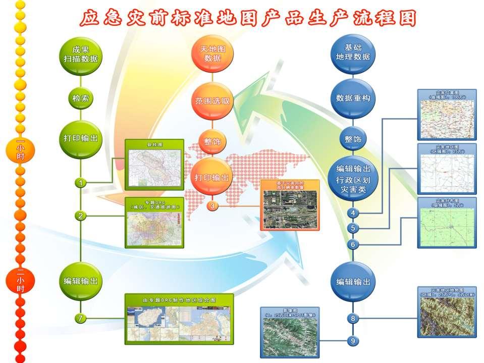
6 1.4 surveying and mapping emergency service work flow 6 start emergency service plan t a s k s existing map or data Providing carry out RS monitoring Thematic map making GIS development image interpretation & assessment information publish 行政区划图准备 基础地理图和数据准备 (3hours) 航空摄影或地面实 测计划启动 (3h) 有关数据 准备 (4h) 应急保障工作全程跟踪报道 (3 hours) 三维演示系统 地理信息服务 平台 遥感解译分析评估系统 基础地图数据准备 遥感影像 解译 专家灾情评估 (3 days) 国外卫星遥感数据 获取与处理 航摄执行 (8h 到达 ) 网站发布最新测绘应急成果提供信息和图件 灾区大比例尺影像图制作 (5 days) 数据生产 (8 hours) 灾前 后专题地图制作 (8 hours ) production standards & time limit
7 7
8 1.5 normal-urgent combined SMGES mechanism 8 Normal-urgent combined, data collection forecast & warning emergency command collect materials, improve equipment improve system improve plan Utilize GIS, RS, thematic map making technologies, staff equipm ent materi als system testing enhance the ability of start plan SMGES for disasters SMGES more efficient and existing map GIS thematic map emergency service sustainable improvement

9 Contents Working Mechanism Geoinformation Resource SMGES Technology SMGES Practice SMGES Surveying,Mapping and Geoinformation Emergency Services


10 Resource 1: national geoinformation base maps 10 1:1,000,000 1:250,000 National 1:50,000 1:10,000 1:5,000 Provincial 1:2000 1:1000 Municipal 1:500

 aerial photography system works at")

11 Resource 2: national basic aerial photogrammetry data getting data of about 0.8 million sq km every year 11 Unmanned Aerial Vehicle(UAV) aerial photography system works at meters high Flexible, efficient and accurate Images taken by UAV above Zhouqu county after the mudslide disaster:


12 Resource 3: satellite remote-sensing image 12 covering range of China by ZY3, tianhui, SPOT5 satellites ZY-3 s global imaging area : about 56 million sq km YUNNAN fire Launched in 2012 Parameters: Mass: 2,630 kg Orbit Altitude: 505 km Revisit Cycle: 5 days Resolution: 2.5-meter Inclination:

13 Resource 4:web-based geoinformation Thematic map making system based on MAPWORLD 13


14 Resource 5: archived data 14 Production value of each county in Sichuan province Archived map data
15 Contents Working Mechanism Geoinformation Resource SMGES Technology SMGES Practice SMGES Surveying,Mapping and Geoinformation Emergency Services

16 3.1 Research and develop on-site emergency response platform 16 System constitute: On site Information collecting system Communication system Host computer Comprehensive application software system Specialized database System Integrating with mapworld


17 3.2 Research and develop Large format digital aerial camera 17 High resolution and accuracy, large format Designated exposure, GCPs are greatly reduced Small size, light weight


18 3.3 Research and develop multi-types of geoinformation service system 18 geoinformation service system for disaster rescue geoinformation service system for disaster assessment geoinformation service system for postdisaster rebuilding


19 3.4 Research and develop emergency thematic map rapid making system types of maps 1-2hours


20 3.5 Research and develop thematic map making system based on MAPWORLD 20 Rapidly make the city high-resolution image map Rapidly select the mapping area Image Downloading and mosaicking Label decoration Rapidly generate image map


21 3.6 Research and develop multiple system of map display 21 Automatical map Multi-media electrical map system on Touch screen Multi-media electrical map system based on IPAD and mobile phone

22 Contents Working Mechanism Geoinformation Resource SMGES Technology SMGES Practice SMGES Surveying,Mapping and Geoinformation Emergency Services


23 4.1 data product service 23 immediately open the Green Channel for data products service Wenchuan earthquake : base maps 1.2TB data Yushu earthquake : 6614 base maps 1324GB data Zhouqu mudslide: 1072 base maps 253.5GB data


24 4.2 thematic map making service for WenChuan earthquake 24 Produced thousands of thematic maps Hypsometric map and political map thematic map which is about the space-time distribution of earthquake intensity Image map which is about severity of damage at different sites Thematic map of post-disaster rebuilding


25 4.2 thematic map making service for Yushu earthquake 25 more than 20 types of rapidly produced maps 514 thematic maps For more than 40 departments


26 4.2 thematic map making service for Zhouqu mudslide disaster 26 After the huge zhouqu mudslide disaster, we offered 1072 thematic maps for the State council and the related departments.


27 4.2 thematic map making service for yiliang earthquake 27 Four hours after the disaster, the UAV conducted aerial photogrammetric Completed 11 types and 116 maps rapidly and offer them in time for the emergency management office of the State Council, and ministry of land and resource and other related departments.
28 4.3 GIS service 28 During the wenchuan earthquake, provide 55 GIS for 41 departments Disaster rescue 3D GIS Disaster assessment Disaster assessment GIS Rebuilding Post-disaster rebuilding GIS 3 periods 3 systems


29 4.4 public service 29 On the website of national dynamic map and NASMG, the newest pre-disaster and postdisaster thematic maps is published immediately Introduce the SMGES in disaster rescue, disaster assessment and post-disaster rebuilding to the public through CCTV


30 4.5 Service for decision making 30


31 2/18/2013
Introduction of Sichuan Surveying and Mapping Emergency System. Zheng Quanhong Sichuan Bureau of Surveying.Mapping and Geoinformation September 2016
 Introduction of Sichuan Surveying and Mapping Emergency System Zheng Quanhong Sichuan Bureau of Surveying.Mapping and Geoinformation September 2016 Background Sichuan province is one of the most serious
Remote Sensing Applications in Agricultural Statistics at China NBS. Yu Xinhua Department of Rural Surveys, National Bureau of Statistics(NBS)
") Remote Sensing Applications in Agricultural Statistics at China NBS Yu Xinhua Department of Rural Surveys, National Bureau of Statistics(NBS) Outline Introduction Remote Sensing Measurement Area Frame
Remote Sensing Applications in Agricultural Statistics at China NBS Yu Xinhua Department of Rural Surveys, National Bureau of Statistics(NBS) Outline Introduction Remote Sensing Measurement Area Frame
ArcGIS 10.1 for Server OGC 标准支持. Esri 中国信息技术有限公司
 ArcGIS 10.1 for Server OGC 标准支持 Esri 中国信息技术有限公司 李光辉 DEMO OpenLayers GoogleEarth Map Services udig OWS Image Service 商业 GIS 软件 ArcGIS for Server GP Services Globe Services GeoCoding Services GeoData Services
Multivariate Statistics Analysis: 多元统计分析
 Multivariate Statistics Analysis: 多元统计分析 Lecture 1: Basic Concept Jun Li ( 李军 ) School of Geography and Planning Sun Yat-Sen University, Guangzhou, China Mobile: 13922375250; Office: D307 E-mail: lijun48@mail.sysu.edu.cn;
Application of Internet+ Field Survey Technology in China s Land Management
 Application of Internet+ Field Survey Technology in China s Land Management Zheng Yu,China Land Surveying and Planning Institute, Land Survey Agency Key words: Internet+, Field Survey, Land Management
能源化学工程专业培养方案. Undergraduate Program for Specialty in Energy Chemical Engineering 专业负责人 : 何平分管院长 : 廖其龙院学术委员会主任 : 李玉香
 能源化学工程专业培养方案 Undergraduate Program for Specialty in Energy Chemical Engineering 专业负责人 : 何平分管院长 : 廖其龙院学术委员会主任 : 李玉香 Director of Specialty: He Ping Executive Dean: Liao Qilong Academic Committee Director:
Design, Development and Application of Northeast Asia Resources and Environment Scientific Expedition Data Platform
 September, 2011 J. Resour. Ecol. 2011 2(3) 266-271 DOI:10.3969/j.issn.1674-764x.2011.03.010 www.jorae.cn Journal of Resources and Ecology Vol.2 No.3 NE Asia Design, Development and Application of Northeast
Improving Surface-based Data Quality through Improved Standardization of Practice and Procedures In Situ Observation Experience & Regional Needs
 Improving Surface-based Data Quality through Improved Standardization of Practice and Procedures In Situ Observation Experience & Regional Needs Dr. Li Bai China Meteorological Administration Dec.2014
Dr. Li, Pengde Deputy to National Peoples Congress of China Deputy Administrator, NASG, China President, UN-GGIM-AP
 Surveying and Mapping Capacity Building and Geo-Information Service in China Dr. Li, Pengde Deputy to National Peoples Congress of China Deputy Administrator, NASG, China President, UN-GGIM-AP 2013 2 12
China Wenchuan Earthquake Disaster (May ) and Its Loss Assessment
 and Its Loss Assessment") International Disaster and Risk Conference Davos 2008, August 25-29, Switzerland China Wenchuan Earthquake Disaster (May 12.2008) and Its Loss Assessment Peijun SHI Disaster Assessment Group of the National
International Disaster and Risk Conference Davos 2008, August 25-29, Switzerland China Wenchuan Earthquake Disaster (May 12.2008) and Its Loss Assessment Peijun SHI Disaster Assessment Group of the National
2012 AP Calculus BC 模拟试卷
 0 AP Calculus BC 模拟试卷 北京新东方罗勇 luoyong@df.cn 0-3- 说明 : 请严格按照实际考试时间进行模拟, 考试时间共 95 分钟 Multiple-Choice section A 部分 : 无计算器 B 部分 : 有计算器 Free-response section A 部分 : 有计算器 B 部分 : 无计算器 总计 45 题 /05 分钟 8 题,55 分钟
The Progress of China-GEOSS
 The 7th GEOSS Asia-Pacific Symposium The Progress of China-GEOSS Dr. YUE Huanyin yuehuanyin@nrscc.gov.cn National Remote Sensing Center of China Ministry of Science and Technology, P. R. China May 26,
Progress of Space Technology Application for Disaster Management in China
 Progress of Space Technology Application for Disaster Management in China LI Qun Department of Disaster Relief Ministry of Civil Affairs of P.R.China Background drought 1 2 flood earthquake typhoon Progress
Remote sensing of haze aerosol over eastern China
 ISALSaRS'17, USTC, 21-June-2017 China University of Mining and Technology Remote sensing of haze aerosol over eastern China Qin Kai( 秦凯 ), CUMT ( 中国矿业大学 ) Wu Lixin, CSU( 中南大学 ) Wong Mansing, Hong Kong
Recovering from the Recovery
 Recovering from the Recovery A Community-level View of Post- Earthquake Planning in the Historic Qiang Minority Ethnic Villages of Sichuan (A Report from the Field) Dan Abramson 艾丹, University of Washington
Introduction to RADI,CAS
 Introduction to RADI,CAS LIU Jie Director of International Cooperation Office June 22, 2016 Beijing China About RADI The RADI is an independent research institute affiliated to the Chinese Academy of Sciences
通量数据质量控制的理论与方法 理加联合科技有限公司
 通量数据质量控制的理论与方法 理加联合科技有限公司 通量变量 Rn = LE + H + G (W m -2 s -1 ) 净辐射 潜热 感热 地表热 通量 通量 通量 通量 Fc (mg m -2 s -1 ) 二氧化碳通量 τ [(kg m s -1 ) m -2 s -1 ] 动量通量 质量控制 1. 概率统计方法 2. 趋势法 3. 大气物理依据 4. 测定实地诊断 5. 仪器物理依据 '
GEOMATICS. Shaping our world. A company of
 GEOMATICS Shaping our world A company of OUR EXPERTISE Geomatics Geomatics plays a mayor role in hydropower, land and water resources, urban development, transport & mobility, renewable energy, and infrastructure
Global and Regional Precipitation Measurement and Applications
 Global and Regional Precipitation Measurement and Applications Yang Hong ( 洪阳 ) 清华大学土木水利学院. 水利水电工程系. 水文水资源所 http://hydrosky.org; hongyang@tsinghua.edu.cn 美国国家天气中心 - 遥感水文气象实验室 (http://hydro.ou.edu) Global
Tsinghua-Berkeley Shenzhen Institute (TBSI) PhD Program Design
 PhD Program Design") 1. SCOPE Tsinghua-Berkeley Shenzhen Institute (TBSI) PhD Program Design (Approved in June, 2018, Applicable to Class 2018) This Ph.D. program is applicable for all doctoral students (including the international
1. SCOPE Tsinghua-Berkeley Shenzhen Institute (TBSI) PhD Program Design (Approved in June, 2018, Applicable to Class 2018) This Ph.D. program is applicable for all doctoral students (including the international
2012 Typhoon Activity Prediction
 2012 Typhoon Activity Prediction Published by Shanghai Typhoon Institute of China Meteorological Administration 4 May 2012 Prediction of 2012 Northwest Pacific Basin and South China Sea Tropical Cyclone
A new operational medium-range numerical weather forecast system of CHINA. NWPD/NMC/CMA (Beijing,CHINA)
") A new operational medium-range numerical weather forecast system of CHINA NWPD/NMC/CMA (Beijing,CHINA) Organizational Chart of CMA NSMC (National Satellite Meteorological Center) NCC (National Climate
A new operational medium-range numerical weather forecast system of CHINA NWPD/NMC/CMA (Beijing,CHINA) Organizational Chart of CMA NSMC (National Satellite Meteorological Center) NCC (National Climate
La pietra da altre colline può levigare la giada di questa qui Il Classico dei Versi 可 以 攻 玉
 T r e n d s o f H e a l t h c a r e P e r f o r m a n c e E v a l u a t i o n i n C h i n a : a n E c o n o m i c a n d S o c i a l A n a l y s i s A t h e s i s p r e s e n t e d b y H a o L i T o T h
Chapter 4. Mobile Radio Propagation Large-Scale Path Loss
 Chapter 4 Mobile Radio Propagation Large-Scale Path Loss The mobile radio channel places fundamental limitations on the performance. The transmission path between the T-R maybe very complexity. Radio channels
Rigorous back analysis of shear strength parameters of landslide slip
 Trans. Nonferrous Met. Soc. China 23(2013) 1459 1464 Rigorous back analysis of shear strength parameters of landslide slip Ke ZHANG 1, Ping CAO 1, Rui BAO 1,2 1. School of Resources and Safety Engineering,
Brief Introduction to China Emergency Early Warning Release Platform
 Brief Introduction to China Emergency Early Warning Release Platform Cheng Zhengquan, Ph.D. Guangdong Meteorological Service, CMA February, 2017 OUTLINE Background Present situation Guangdong Emergency
Progress in Meteorological Hazard Risk Operation in China
 Progress in Meteorological Hazard Risk Operation in China China Meteorological Administration Department of Emergency Response,Disaster Mitigation and Public Services Jiang Yan 2018-11-20 CONTENTS 1 2
Mechatronics Engineering Course Introduction
 Mechatronics Engineering Course Introduction Prof. Tianmiao Wang Prof. Li Wen School of Mechanical Engineering and Automation Beihang University 6/10/201 Professor biography Li Wen, Associate professor
The dynamic N1-methyladenosine methylome in eukaryotic messenger RNA 报告人 : 沈胤
 The dynamic N1-methyladenosine methylome in eukaryotic messenger RNA 报告人 : 沈胤 2016.12.26 研究背景 RNA 甲基化作为表观遗传学研究的重要内容之一, 是指发生在 RNA 分子上不同位置的甲基化修饰现象 RNA 甲基化在调控基因表达 剪接 RNA 编辑 RNA 稳定性 控制 mrna 寿命和降解等方面可能扮演重要角色
Status and Data Applications of China Highresolution Earth Observation System. Earth Observation System and Data Center, CNSA Sep, 2016
 Status and Data Applications of China Highresolution Earth Observation System Earth Observation System and Data Center, CNSA Sep, 2016 Outlines Introduction Development of the Space-based System CHEOS
An IntRoduction to grey methods by using R
 An IntRoduction to grey methods by using R Tan Xi Department of Statistics, NUFE Nov 6, 2009 2009-2-5 Contents: A brief introduction to Grey Methods An analysis of Degree of Grey Incidence Grey GM(, )
Remote Sensing Classification of Marsh Wetland with Different Resolution Images
 March, 2016 Journal of Resources and Ecology Vol. 7 No.2 J. Resour. Ecol. 2016 7(2) 107-114 DOI: 10.5814/j.issn.1674-764x.2016.02.005 www.jorae.cn Article Remote Sensing Classification of Marsh Wetland
Progress Report. Flood Hazard Mapping in Thailand
 Progress Report Flood Hazard Mapping in Thailand Prepared By: Mr. PAITOON NAKTAE Chief of Safety Standard sub-beuro Disaster Prevention beuro Department of Disaster Prevention and Mitigation THAILAND E-mail:
Can phylogenomic data matrix end incongruence in the tree of life?
 Can phylogenomic data matrix end incongruence in the tree of life? 系统发育基因组数据能否解决生命之树中的冲突? Xing-Xing Shen( 沈星星 ) https://xingxingshen.github.io/ Rokas Lab Mar 2018 1 自我简介 https://xingxingshen.github.io/
Digital Image Processing. Point Processing( 点处理 )
") Digital Image Processing Point Processing( 点处理 ) Point Processing of Images In a digital image, point = pixel. Point processing transforms a pixel s value as function of its value alone; it it does not
Digital Image Processing Point Processing( 点处理 ) Point Processing of Images In a digital image, point = pixel. Point processing transforms a pixel s value as function of its value alone; it it does not
FY-3/FY-4 satellite development/ application review and future plan
 The 4 th THORPEX-Asia science workshop&9 th ARC meeting, Oct. 30, 2012 FY-3/FY-4 satellite development/ application review and future plan Tang Shihao E-mail : tangsh@cma.gov.cn Tel/Fax: 86-10-68407250
QTM - QUALITY TOOLS' MANUAL.
 1 2.4.1 Design Of Experiments (DOE) 1. Definition Experimentation is a systematic approach to answer questions and more specifically; how do changes to a system actually affect the quality function or
Establishment and data analysis of sea-state monitoring system along Taiwan coast
 Vol. 14 No. 1 Marine Science Bulletin May 2012 Establishment and data analysis of sea-state monitoring system along Taiwan coast FENG Xiang-bo 1,2, WANG Hao 1,2, YAN Yi-xin 1,2 1. Key Laboratory of Coastal
Wanju BO, Shengtao FENG and Jianfeng SU, China. Key words: GNSS, vertical component, crust movement, strong earthquake activity
 Study on Large Area Crust Deformation with GNSS Vertical Components Wanju BO, Shengtao FENG and Jianfeng SU, China Key words: GNSS, vertical component, crust movement, strong earthquake activity SUMMARY
系统生物学. (Systems Biology) 马彬广
 马彬广") 系统生物学 (Systems Biology) 马彬广 通用建模工具 ( 第十四讲 ) 梗概 (Synopsis) 通用建模工具 ( 数学计算软件 ) 专用建模工具 ( 细胞生化体系建模 ) 通用建模工具 主要是各种数学计算软件, 有些是商业软件, 有些是自由软件 商业软件, 主要介绍 : MatLab, Mathematica, Maple, 另有 MuPAD, 现已被 MatLab 收购 自由软件
系统生物学 (Systems Biology) 马彬广 通用建模工具 ( 第十四讲 ) 梗概 (Synopsis) 通用建模工具 ( 数学计算软件 ) 专用建模工具 ( 细胞生化体系建模 ) 通用建模工具 主要是各种数学计算软件, 有些是商业软件, 有些是自由软件 商业软件, 主要介绍 : MatLab, Mathematica, Maple, 另有 MuPAD, 现已被 MatLab 收购 自由软件
Quantitative Assessment of Seismic Mortality Risks in China
 March, 2011 J. Resour. Ecol. 2011 2(1) 83-90 DOI:10.3969/j.issn.1674-764x.2011.01.012 www.jorae.cn Journal of Resources and Ecology Vol.2 No.1 Article Quantitative Assessment of Seismic Mortality Risks
Part : General Situation of Surveying and Mapping. The Development of Surveying and Mapping in China. The contents
 The Development of Surveying and Mapping in China Dr. Ping Xiao China.P.R The contents Part : General Situation of Surveying and Mapping 1. The legal systems of surveying and mapping 2. The technologies
Content. 1. Introduction. 2. Strengthening Unified Supervision of Surveying and Mapping. 3. Geospatial Information Resources and Utilization
 1. Introduction Content 2. Strengthening Unified Supervision of Surveying and Mapping 3. Geospatial Information Resources and Utilization 4. Current Situation of the Geospatial Industry 5. Opportunities
Spatial-temporal Changes in Ecological Risk of Land Use before and after Grain-for-Green Policy in Zhengning County, Gansu Province
 March, 2013 Journal of Resources and Ecology Vol.4 No.1 J. Resour. Ecol. 2013 4 (1) 036-042 DOI:10.5814/j.issn.1674-764x.2013.01.005 www.jorae.cn rticle Spatial-temporal Changes in Ecological Risk of Land
2011 Typhoon Activity Prediction
 2011 Typhoon Activity Prediction Published by Shanghai Typhoon Institute of China Meteorological Administration April 21th, 2011 Prediction of 2011 Northwest Pacific Basin and South China Sea Tropical
Strategic Framework and Practice of Sichuan. Provincial Emergency Surveying and Mapping
 Strategic Framework and Practice of Sichuan PPT www.1ppt.com/moban/ Provincial Emergency Surveying and Mapping Zheng Quanhong Sichuan Bureau of Surveying Mapping and Geoinfomation Contents 1. Background
Surface Connects Author Index
 Surface Connects Author Index Shixin WANG, Yi ZHOU, Gewei LI, Weiqi ZHOU, Yalan LIU & Shirong CHEN NETWORK PLATFORM OF REMOTE SENSING FOR NATURAL DISASTER MONITORING & INFORMATION SERVING AND ITS APPLICATIONS
Microbiology. Zhao Liping 赵立平 Chen Feng. School of Life Science and Technology, Shanghai Jiao Tong University
 1896 1920 1987 2006 Microbiology By Zhao Liping 赵立平 Chen Feng 陈峰 School of Life Science and Technology, Shanghai Jiao Tong University http://micro.sjtu.edu.cn 1896 1920 1987 2006 Preface : Introduction
GI Technology for Disaster Management
 GI Technology for Disaster Management 17 th ICC on the Regional Space Applications Programme for Sustainable Development (RESAP) 26 th Nov 2013 Bangkok Thailand Period and time of seasonal in thailand
USING GIS CARTOGRAPHIC MODELING TO ANALYSIS SPATIAL DISTRIBUTION OF LANDSLIDE SENSITIVE AREAS IN YANGMINGSHAN NATIONAL PARK, TAIWAN
 CO-145 USING GIS CARTOGRAPHIC MODELING TO ANALYSIS SPATIAL DISTRIBUTION OF LANDSLIDE SENSITIVE AREAS IN YANGMINGSHAN NATIONAL PARK, TAIWAN DING Y.C. Chinese Culture University., TAIPEI, TAIWAN, PROVINCE
THE STUDY ON 4S TECHNOLOGY IN THE COMMAND OF EARTHQUAKE DISASTER EMERGENCY 1
 THE STUDY ON 4S TECHNOLOGY IN THE COMMAND OF EARTHQUAKE DISASTER EMERGENCY 1 Zhou Wensheng 1, Huang Jianxi 2, Li Qiang 3, Liu Ze 3 1 Associate Professor, School of Architecture, Tsinghua University, Beijing.
Concurrent Engineering Pdf Ebook Download >>> DOWNLOAD
 1 / 6 Concurrent Engineering Pdf Ebook Download >>> DOWNLOAD 2 / 6 3 / 6 Rozenfeld, WEversheim, HKroll - Springer.US - 1998 WDuring 2005 年 3 月 1 日 - For.the.journal,.see.Conc urrent.engineering.(journal)verhagen
EIC. 来自德国的专业 OEM 全方位解决方案供应商 A professional OEM supplier from Germany. 德仕科技 ( 深圳 ) 有限公司 ELEKTRA Industrial China Co., Ltd.
 有限公司 ELEKTRA Industrial China Co., Ltd.") 松福大道 SongFu Avenue 松福大道 SongFu Avenue 凯嘉酒店 KaiJia Hotel 田园酒店 TianYuan Hotel 德仕科技 ( 深圳 ) 有限公司 ELEKTRA Industrial China Co., Ltd. 邮政储蓄银行 Postal Savings Bank 永和路 YongHe Road 西环路 XiHuan Road 永福路 YongFu Road
松福大道 SongFu Avenue 松福大道 SongFu Avenue 凯嘉酒店 KaiJia Hotel 田园酒店 TianYuan Hotel 德仕科技 ( 深圳 ) 有限公司 ELEKTRA Industrial China Co., Ltd. 邮政储蓄银行 Postal Savings Bank 永和路 YongHe Road 西环路 XiHuan Road 永福路 YongFu Road
Integrated Algebra. Simplified Chinese. Problem Solving
 Problem Solving algebraically concept conjecture constraint equivalent formulate generalization graphically multiple representations numerically parameter pattern relative efficiency strategy verbally
Audit Report 30 JUN Jiangxi Provincial Audit Office of the People's Republic of China GAN AUDIT REPORT C2016) NO. 2. gl)kf4k [ #
 NO. 2. gl)kf4k [ #") Public Disclosure Authorized Jiangxi Provincial Audit Office of the People's Republic of China 30 JUN 2016 Public Disclosure Authorized Audit Report gl)kf4k [20163 2-# GAN AUDIT REPORT C2016) NO. 2 Public
Public Disclosure Authorized Jiangxi Provincial Audit Office of the People's Republic of China 30 JUN 2016 Public Disclosure Authorized Audit Report gl)kf4k [20163 2-# GAN AUDIT REPORT C2016) NO. 2 Public
Geo-information and Disaster Risk Reduction in the Hindu Kush-Himalayan region
 Geo-information and Disaster Risk Reduction in the Hindu Kush-Himalayan region Basanta Shrestha, Division Head MENRIS, International Centre for Integrated Mountain Development Kathmandu, Nepal The International
国际数值预报现状和发展 沈学顺 中国气象局数值预报中心
 国际数值预报现状和发展 沈学顺 中国气象局数值预报中心 提纲 背景介绍 国际数值预报现状和水平 未来发展 一 背景介绍 What is Numerical Weather Prediction? The technique used to obtain an objective forecast of the future weather (up to possibly two weeks) by
RiskCity Training package on the Application of GIS for multi- hazard risk assessment in an urban environment.
 RiskCity Training package on the Application of GIS for multi- hazard risk assessment in an urban environment. Cees van Westen (Westen@itc.nl) & Nanette C. Kingma (Kingma@itc.nl) ITC: Training & Research
第五届控制科学与工程前沿论坛 高志强. Center for Advanced Control Technologies
 第五届控制科学与工程前沿论坛 自抗扰控制技术的理念 方法与应用 纪念韩京清先生逝世五周年 高志强 二零一三年四月十九日 Center for Advanced Control Technologies http://cact.csuohio.edu 概要 引言自抗扰控制的渊源自抗扰控制的应用自抗扰控制的论证抗扰技术研究小结 引言 君子务本, 本立而道生 韩京清 :1937-2008 六十年代 : 最优控制,
Explainable Recommendation: Theory and Applications
 Explainable Recommendation: Theory and Applications Dissertation Submitted to Tsinghua University in partial fulfillment of the requirement for the degree of Doctor of Philosophy in Computer Science and
The Third UN-GGIM-AP Plenary Meeting. Use of Geospatial Information in Disaster and Coordination among NDMA and Relevant Organizations/Stakeholders
 The Third UN-GGIM-AP Plenary Meeting Use of Geospatial Information in Disaster and Coordination among NDMA and Relevant Organizations/Stakeholders Bali Indonesia 10 November 2014 Bernardus Wisnu Widjaja
Human CXCL9 / MIG ELISA Kit
 Human CXCL9 / MIG ELISA Kit Catalog Number: KIT10888 Please read this instruction manual carefully before using the product. For Research Use Only. Not for use in diagnostic or therapeutic procedures.
ASSESSING THE QUALITY OF OPEN ACCESS JOURNALS
 ASSESSING THE QUALITY OF OPEN ACCESS JOURNALS 审核开放获取期刊的质量 S E M I N A R A T C H I N A O P E N A C C E S S W E E K O C T O B E R 1 9, 2 0 1 6, B E I J I N G T O M @ D O A J. O R G E D I T O R - I N - C
Government GIS and its Application for Decision Support
 Government GIS and its Application for Decision Support Zhang Qingpu (Chinese Academy of Surveying and Mapping, Email: zhangqp@casm.ac.cn) Abstract: Application of GIS in government agencies is called
ÖBB Natural Hazard Management
 ÖBB Natural Hazard Management Management of Weather Events in the Austrian Federal Railways MOWE-IT, Brussels 17 th of September 2013 DI Günther Kundela Integrated Track Management Integration Technic
Atmospheric Water Vapor Real-Time Monitoring System in Pearl- River-Delta Region Using GPS/GNSS 珠三角地区基于 GPS/GNSS 技术的大气水汽实时监测系统
 Atmospheric Water Vapor Real-Time Monitoring System in Pearl- River-Delta Region Using GPS/GNSS 珠三角地区基于 GPS/GNSS 技术的大气水汽实时监测系统 刘志赵 1 李敏 1,2 1 Department of Land Surveying & Geo-Informatics The Hong Kong
Contents. PLUS Factorization of Matrices and Its Applications. 1. Background. 1. Background 2. Main Achievements 3. Applications 4.
 PLUS Factorization of Matrices and Its Applications Pengwei Hao Center for Inforation Science, Peking University Contents 1 Background 2 Main Achieveents 3 Applications 4 Unsolved Probles Queen Mary, University
Disaster Prevention and Management Taiwan Experience
 5 th Joint Project Team Meeting for Sentinel Asia STEP 3 (JPTM 2018) Disaster Prevention and Management Taiwan Experience TZU-YIN CHANG National Science and Technology Center for Disaster Reduction (NCDR)
Physical design of photo-neutron source based on 15 MeV Electron Linac accelerator and Its Application
 TMSR Physical design of photo-neutron source based on 15 MeV Electron Linac accelerator and Its Application WANG Hongwei 10/2012 on behalf of Reactor Physics Division of TMSR Nuclear Physics Division Shanghai
Cooling rate of water
 Cooling rate of water Group 5: Xihui Yuan, Wenjing Song, Ming Zhong, Kaiyue Chen, Yue Zhao, Xiangxie Li 目录. Abstract:... 2. Introduction:... 2 2.. Statement of the problem:... 2 2.2 objectives:... 2 2.3.
Regional EGM on Community of Practice of Georeferenced Information System. for Disaster Risk Management (Geo-DRM) April 2014, Bangkok, Thailand
 April 2014, Bangkok, Thailand") Regional EGM on Community of Practice of Georeferenced Information System for Disaster Risk Management (Geo-DRM) 23-25 April 2014, Bangkok, Thailand Presented By Mukesh Kumar Keshari Ministry of Home Affairs
Regional EGM on Community of Practice of Georeferenced Information System for Disaster Risk Management (Geo-DRM) 23-25 April 2014, Bangkok, Thailand Presented By Mukesh Kumar Keshari Ministry of Home Affairs
李真江苏南京市卫岗 1 号南京农业大学资环学院办公室 : 资环学院大楼 A219 教育与工作经历 学术兼职与服务 获奖经历 主持项目
 李真江苏南京市卫岗 1 号南京农业大学资环学院办公室 : 资环学院大楼 A219 E-mail: lizhen@njau.edu.cn Tel:025-84399827 李真博士主要结合磷灰石, 解磷菌, 以及其他微生物 ( 如 AMF) 在土壤中研究磷的地球化学和生态循环 在基础研究上主要解析 1) 磷素的高效释放机理 ;2) 微生物 - 矿物 - 植物三因子相互作用 ;3) 磷元素的生物矿化过程
2NA. MAYFLOWER SECONDARY SCHOOL 2018 SEMESTER ONE EXAMINATION Format Topics Comments. Exam Duration. Number. Conducted during lesson time
 Art NA T2 W3-W6 Project Work 1) Investigation and Interpretation of Theme 2) Control of Technical Processes 3) Reflection Conducted during lesson time Bahasa Melayu Express Stream SBB 1 2h Bahagian A E-mel
Service Bulletin-04 真空电容的外形尺寸
 Plasma Control Technologies Service Bulletin-04 真空电容的外形尺寸 在安装或者拆装真空电容时, 由于真空电容的电级片很容易移位, 所以要特别注意避免对电容的损伤, 这对于过去的玻璃电容来说非常明显, 但对于如今的陶瓷电容则不那么明显, 因为它们能够承载更高的机械的 电性能的负载及热负载 尽管从外表看来电容非常结实, 但是应当注意, 由于采用焊接工艺来封装铜和陶瓷,
Multivariate Statistics Analysis: 多元统计分析
 Multivariate Statistics Analysis: 多元统计分析 Course introduction Jun Li ( 李军 ) School of Geography and Planning Sun Yat-Sen University, Guangzhou, China Mobile: 13922375250; Office: D307 E-mail: lijun48@mail.sysu.edu.cn;
AND THE COOPERATION WITH SENTINEL ASIA FOR DISASTER MANAGEMENT
 Ministry of Natural resources and Environment National Remote Sensing DEpartment NATIONAL REMOTE SENSING DEPARTMENT (NRSD) AND THE COOPERATION WITH SENTINEL ASIA FOR DISASTER MANAGEMENT By: Dr. Chu Hai
MAX481/MAX483/MAX485/ MAX487 MAX491/MAX1487
 ILLE 9-; ev 9; 9/9 MX/MX/MX/ MX MX9/MX S-/S- MX MX MX MX MX9 MX S- S- MX MX MX MX9 EMI kbps MX MX MX9 MX9 MX.Mbps μ μ MX MX MX.μ MX MX MX/MX MX MX9 MX MX MX MX MX S- S- EMI MX: ± / +. S- MXE MXE: ±k ES
Towards the Future of Geomatics Science Its Global Impacts
 Panel Discussion Towards the Future of Geomatics Science Its Global Impacts Wuhan University Prof. Li Deren 19 th -20 th Nov. 2018, Deqing, China Definition of Geomatics (ISO,1996) Geomatics is a field
复杂航天领域动态 2016 年第 5 期 ( 总第 5 期 ) 2016 年 10 月 本期目录 研究动态: 星上信息处理与应用... 1 星上实时信息处理... 1 嵌入式实时信息处理... 2 星载图像信息处理... 3 天基图像目标检测技术... 4 信息交互...
 2016 年 10 月 本期目录 研究动态: 星上信息处理与应用... 1 星上实时信息处理... 1 嵌入式实时信息处理... 2 星载图像信息处理... 3 天基图像目标检测技术... 4 信息交互...") 复杂航天领域动态 2016 年第 5 期 ( 总第 5 期 ) 2016 年 10 月 本期目录 研究动态: 星上信息处理与应用... 1 星上实时信息处理... 1 嵌入式实时信息处理... 2 星载图像信息处理... 3 天基图像目标检测技术... 4 信息交互... 4 时空数据挖掘... 5 星载数据融合专题... 6 中国 (15 篇 )... 6 美国 (6 篇 )... 7 德国 (6
复杂航天领域动态 2016 年第 5 期 ( 总第 5 期 ) 2016 年 10 月 本期目录 研究动态: 星上信息处理与应用... 1 星上实时信息处理... 1 嵌入式实时信息处理... 2 星载图像信息处理... 3 天基图像目标检测技术... 4 信息交互... 4 时空数据挖掘... 5 星载数据融合专题... 6 中国 (15 篇 )... 6 美国 (6 篇 )... 7 德国 (6
Function and Composition
 Function and Composition In order to strengthen the study of typhoon mechanism, China Aerospace Science and Industry Corporation (CASIC) and China Meteorological Administration organized and implemented
Riemann s Hypothesis and Conjecture of Birch and Swinnerton-Dyer are False
 Riemann s Hypothesis and Conjecture of Birch and Swinnerton-yer are False Chun-Xuan Jiang. O. Box 3924, Beijing 854 China jcxuan@sina.com Abstract All eyes are on the Riemann s hypothesis, zeta and L-functions,
Key Topic. Body Composition Analysis (BCA) on lab animals with NMR 采用核磁共振分析实验鼠的体内组分. TD-NMR and Body Composition Analysis for Lab Animals
 on lab animals with NMR 采用核磁共振分析实验鼠的体内组分. TD-NMR and Body Composition Analysis for Lab Animals") TD-NMR and Body Composition Analysis for Lab Animals 时域磁共振及实验鼠体内组分的测量 Z. Harry Xie ( 谢宗海 谢宗海 ), PhD Bruker Optics, Inc. Key Topic Body Composition Analysis (BCA) on lab animals with NMR 采用核磁共振分析实验鼠的体内组分
TD-NMR and Body Composition Analysis for Lab Animals 时域磁共振及实验鼠体内组分的测量 Z. Harry Xie ( 谢宗海 谢宗海 ), PhD Bruker Optics, Inc. Key Topic Body Composition Analysis (BCA) on lab animals with NMR 采用核磁共振分析实验鼠的体内组分
Georeferencing and Satellite Image Support: Lessons learned, Challenges and Opportunities
 Georeferencing and Satellite Image Support: Lessons learned, Challenges and Opportunities Shirish Ravan shirish.ravan@unoosa.org UN-SPIDER United Nations Office for Outer Space Affairs (UNOOSA) UN-SPIDER
Earth Observation System and its application to disaster management and emergency response in China
 Earth Observation System and its application to disaster management and emergency response in China Prof. Meng Qingyan Institute of Remote Sensing Applications Chinese Academy of Sciences November 22,
Development of Tropical cyclone objective analysis technique based on FY serial satellite data
 2 nd International Workshop On Satellite Analysis of Tropical Cyclones (IWSATC-2) Update on Objective Satellite-Based TC Analysis Methods 18 February 2016 Honolulu, Hawaii, USA Development of Tropical
NGIAs' roles in successful disaster response
 The Second UN-GGIM-AP Plenary Meeting NGIAs' roles in successful disaster response Japan Teheran Iran 28 October 2013 Shin-ichi SAKABE, Director of International Affairs Division Geospatial Information
Roles of NGII in successful disaster management
 The Second UN-GGIM-AP Plenary Meeting Roles of NGII in successful disaster management Republic of Korea Teheran Iran 28 October 2013 Sanghoon Lee, Ph.D. NGII Outline Type of Disasters Occur in Korea Practical
Synthesis of PdS Au nanorods with asymmetric tips with improved H2 production efficiency in water splitting and increased photostability
 Chinese Journal of Catalysis 39 (2018) 407 412 催化学报 2018 年第 39 卷第 3 期 www.cjcatal.org available at www.sciencedirect.com journal homepage: www.elsevier.com/locate/chnjc Communication (Special Issue of
Disaster RISK Management : Bhutanese Scenario
 Disaster RISK Management : Bhutanese Scenario Expert Group Meeting (EGM) on Geo-referenced Information Systems for Disaster Risk Management (Geo-DRM) and sustaining the Community of Practice (COP), Bangkok,
Construction of Emergency Services Platform for Coal Mining Accidents by Integrating Multi Source Datasets
 Construction of Emergency Services Platform for Coal Mining Accidents by Integrating Multi Source Datasets Jin LIU Geological Environmental Center of Shanxi Province, Taiyuan, Shanxi 030024, China Abstract
Applications of Special Sensor Microwave Imager and Sounder (SSMIS) Measurements in Weather and Climate Studies
 Measurements in Weather and Climate Studies") 气象科技进展 Applications of Special Sensor Microwave Imager and Sounder (SSMIS) Measurements in Weather and Climate Studies Weng F 1,2, Zou X* 3,4, Yan B 2, Han Y 1,2, Liu Q 2,5 (1 NOAA/NESDIS/Center for Satellite
气象科技进展 Applications of Special Sensor Microwave Imager and Sounder (SSMIS) Measurements in Weather and Climate Studies Weng F 1,2, Zou X* 3,4, Yan B 2, Han Y 1,2, Liu Q 2,5 (1 NOAA/NESDIS/Center for Satellite
钽电解电容器 选型指南 2013 版 宁夏星日电子有限公司. Selection Guide For Tantalum Electrolytic Capacitor NINGXIA XINGRI ELECTRONICS CO., LTD
 钽电解电容器 Selection Guide or Tantalum lectrolytic apacitor 选型指南 版 宁夏星日电子有限公司 NINGXI XINGI LTONIS O., LT 特点与用途 模压封装 表面贴装 体积小 重量轻 极性电容器 ; 电性能优良稳定 可靠性高 寿命长 贮存稳定性好 ; 符合欧盟 ohs 和 H 法规的无铅要求 ; 适用于通讯 计算机 摄像机 移动通讯等领域
2004 Journal of Software 软件学报
 000-9825/2004/5(07)0977 2004 Journal of Software 软件学报 Vol5, No7 如何测量 SMP 机群可扩放性 何家华 +, 陈国良, 单久龙 ( 中国科学技术大学计算机科学技术系国家高性能计算中心 ( 合肥 ), 安徽合肥 230027) How to Measure Scalability of SMP Cluster HE Jia-Hua +,
A STUDY OF FACTORS THAT AFFECT CAPILLARY
 20/6/ GROUP A STUDY OF FACTORS THAT AFFECT CAPILLARY DOE Project Report 杨路怡陆泓宇陈驰 Content Abstract... 4 Experiment Background & Objective... 4 Background... 4 Objective... 5 Experiment Principles... 5 Phenomenon
3-04 東 東南アジアの地質情報総合データベースの構築 : CCOP 地質情報総合共有プロジェクト
 3-04 東 東南アジアの地質情報総合データベースの構築 : CCOP 地質情報総合共有プロジェクト 宝田晋治 1 Joel Bandibas 1 Constructing a comprehensive geoscience database in East and Southeast Asia: CCOP Geoinformation Sharing Infrastructure for East
DISATER MANAGEMENT IN LIBRARIES
 DISATER MANAGEMENT IN LIBRARIES by S. Padmashree National Seminar cum Workshop on Trends & Challenges in LIS Education and Profession March 24 25 th 2017 Andhra University, Visakhapatnam Disaster - A
Intelligent City Management
 Intelligent City Management Based on Land Cover Feature Changes Detected by Satellite Imagery Twenty First Century Aerospace Technology (21AT) www.21at.com.cn Geospatial World Forum 2016 Outline 01 Introduction
Source mechanism solution
 Source mechanism solution Contents Source mechanism solution 1 1. A general introduction 1 2. A step-by-step guide 1 Step-1: Prepare data files 1 Step-2: Start GeoTaos or GeoTaos_Map 2 Step-3: Convert
Introduction of PASCO Corporation
 Technical Seminar Reference Frame in Practice, Introduction of PASCO Corporation MASAKI MIYASAKA Sponsors: Page 1 Company Profile Establishment: October 27, 1953 Head office: Meguro-ku, Tokyo (57 offices