Avalon Marshes Landscape
|
|
|
- Valerie Snow
- 6 years ago
- Views:
Transcription


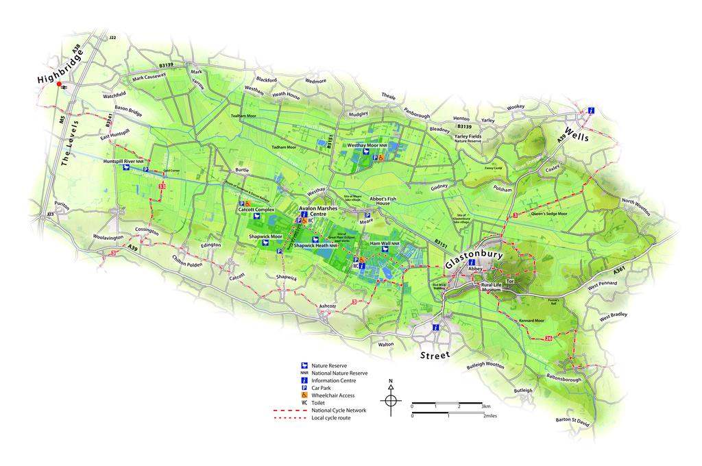
1 Avalon Marshes Landscape Mapping the Marshes KS2 & KS3 Outline The Avalon Marshes is a unique and interesting landscape and this set of resources is designed to help Description pupils interact with the landscape whilst developing their geographical skills through the use of maps and grid-references. Time 45 minutes Print outs of the maps of your choice. Prints outs of Ordnance Survey map symbol flashcards, if you want to Equipment use them ( You can also incorporate compasses. Curriculum Year 4 Maths describe positions on a 2-D grid as co-ordinates. KS2 Geography use the eight points of a compass, four and six figure grid references, symbols and key, to build pupils knowledge of the UK KS3 Geography understand how geographical processes interacts to create distinctive landscapes that change over time. Aims Learning outcomes Linked resources Use maps, symbols, and grid references to explore the landscape of the Avalon Marshes Improve skills in mapping and the use of grid references Following this activity pupils should be able to: Give examples of places of interest in the Avalon Marshes Describe a journey through the Avalon Marshes Introduction to the Avalon Marshes Pick & Mix: Getting to Know Peat; Avalon Marshes Timeline; Water in the Wetlands; Avalon Marshes Quiz Factsheets: The Avalon Marshes Specialist equipment: Avalon Marshes Floor Map Avalon Marshes Centre Shapwick Road, Westhay, Somerset, BA6 9TT
2 Avalon Marshes Landscape Teachers notes This file contains the following resources: 1. A page on map symbols to display on your projector or interactive white board. 2. An Avalon Marshes locator page to display on your projector/iwb, to help pupils understand where the Avalon Marshes is. 3. A detailed map of the Avalon Marshes this can be displayed on the projector/iwb, and can also be printed out for pupils to label and annotate. 4. Two gridded maps of the Avalon Marshes for pupils to learn about and practice a) 2 figure grid references and co-ordinates, b) 4 and 6 figure grid references. 5. Images of points of interest. Preparation Print the maps and worksheets that you want to use. Have a look at the Ordnance Survey map symbol flashcards online they can be download for free here Discuss compass points with your class, and talk about other important features of maps (key, symbols, scale etc). The OS map symbol flash cards can be used here. Introduce the Avalon Marshes to your pupils. Look at where the Avalon Marshes is in the UK, then look at the more detailed map. Can they find Glastonbury town? Why are some place names bigger than others? Can they find Glastonbury Tor? Can they spot a river? A nature reserve? Ask them to point or draw an arrow in the direction of the sea. If you are a local school, find your school on the map; ask pupils to find their town/village on the map, or other places that are important to them. If you have printed out maps, ask pupils to mark places of interest by adding new symbols and creating an extra key (e.g. an S for school ). This activity works well linked to the Avalon Marshes Timeline activity if using this, ask pupils to find heritage features on their map and make notes about what happened there, and when (e.g. The Sweet Track, built in 3806 BC). The gridded maps can be used for introducing and practicing 2/4/6 figure grid references. Add extra points of interest too (e.g. the school). To end: Ask pupils to give examples from the map of: of a place that people could visit to see wildlife; an archaeological site; a place to find out about history; a village where people live in the Avalon Marshes; a river that runs through the Avalon Marshes; a town in or close to the Avalon Marshes. Extension: Ask pupils to pretend they are guides on a tour bus travelling through the Avalon Marshes they should describe to their passengers what interesting places they are passing, and what can be seen out of the window. Print a large (A3) copy of the map and put it on the wall. Print and cut-out the images of points of interest and place them around the map, and use string and pins to show where they are on the map. Hire the Avalon Marshes Floor Map and do further landscape explorations and map work. Make 3D models to represent points of interest, and place them on the large map (e.g. the Sweet Track, Glastonbury Tor, Glastonbury Lake Village, Glastonbury Abbey, Fenny Castle). Or find images online of the Marshes, print them, and place them on the map. Avalon Marshes Centre Shapwick Road, Westhay, Somerset, BA6 9TT


3 What do you think these map symbols mean? WC What do the colours green and blue show on this map?

4 The Avalon Marshes Somerset, UK
5

6 A B C D E F G H Find these places on the map and write a 2 figure grid reference for them: Shapwick Moor Nature Reserve D2 Ham Wall NNR Westhay Moor NNR Glastonbury Lake Village Abbot s Fish House Glastonbury Tor Give one example of what you find at each of these references: D3 Westhay F1 A4 H2 B3
7 Write a 4 figure grid reference for the following places: Glastonbury Abbey Abbot s fish House Huntspill River NNR Shapwick What important landscape feature do you find in 2631? What important archaeological discovery do you find in 2331? Write a 6 figure grid reference for the site of the Glastonbury Lake Village:


8 Abbot s Fish House Site of Glastonbury Lake Village Glastonbury Ham Wall NNR Gold Corner Pumping Station Site of the Edington Hoard Glastonbury Abbey Image: Joy Russell Westhay Moor NNR Glastonbury Tor Image: Peter Alexander Site of Eclipse Peat Works Image: E Mortlemans Site of the Sweet Track Site of Shapwick Station
Landmarks Paula Owens 5 7 years
 Landmarks Paula Owens Geography teaching resource 5 7 years This is one of a series of teaching resources for use with Digimap for Schools. For more details about this service, visit http://digimapforschools.edina.ac.uk
of places Key stage 1 Key stage 2 describe places
 Unit 25 Geography and numbers ABOUT THE UNIT This continuous unit aims to show how geographical enquiry can provide a meaningful context for the teaching and reinforcement of many aspects of the framework
Subject: Geography Scheme of Work: B1 to B6 Mastery tiles. Term: Autumn/Spring/Summer
 Subject: Geography Scheme of Work: B1 to B6 Mastery tiles Term: Autumn/Spring/Summer Topic / Unit(s) Overview / Context Introduction to geography. An introduction to geography including basic map skills
The maps in this resource can be freely modified and reproduced in the classroom only.
 Teacher's Notes In this activity, students work collaboratively to explore sections of old and new maps. By closely examining these documents, students learn to see maps as more than just tools for locating
Using OS Resources - A fieldwork activity for Key Stage 2
 Using OS Resources - A fieldwork activity for Key Stage 2 Liz Spincer, Saltford CE Primary School Outline of the fieldwork project: This series of activities was designed to illustrate how Primary School
Teaching Resource for KS2 Investigating Rivers
 Teaching Resource for KS2 Investigating Rivers The Parrett Catchment Project Edited by Sam Woodhouse Page 2 Scheme of Work Investigating Rivers An adaptation of the KS2 unit on rivers and water About this
Map reading made easy
 Map reading made easy 1. What is a map? A map is simply a drawing or picture (in 2-D) of a landscape or area of a country (in 3-D). It could be anything from a sketch map for a visitor to find your school
Picture Detectives. Geography teaching resource
 Picture Detectives Matching images and clues to map references Paula Owens Geography teaching resource Primary Digimap for Schools Geography Resources These resources are a guide for teachers to demonstrate
Map reading made easy
 Map reading made easy 1 1. What is a map? A map is simply a drawing or picture (in 2-D) of a landscape or area of a country (in 3-D). It could be anything from a sketch map for a visitor to find your school
Geography Resources. Paula Owens. Teifi Travels. Key Stage 2
 Geography Resources Key Stage 2 Teifi Travels by Paula Owens About Digimap for Schools Digimap for Schools is an online mapping service for use by teachers and pupils providing easy access to a range of
Walworth Primary School
 Walworth Primary School Date: April 2016 Revision Due: April 2017 Ref: L.Smith Geography Policy 1 Geography Policy Introduction A high quality geography education should inspire in pupils a curiosity and
Map reading made easy
 Map reading made easy Maps can be great fun and they can lead you to all sorts of discoveries. They can help you get to know an area really well, because they pinpoint interesting places that are often
Teifi Travels Social and environmental features along a river
 Teifi Travels Social and environmental features along a river Paula Owens Geography teaching resource Secondary Digimap for Schools Geography Resources Title: Teifi Travels Level Context Location Secondary
Children needing support to achieve key skills. Children surpassing key skills. Geography Progression in Skills Key Stage One. Locational Knowledge
 Skills Locational Knowledge Geography Progression in Skills Key Stage One Children needing support to achieve key skills Children surpassing key skills To understand that the world extends outside their
Progression of skills in Geography
 New Curriculum Holy Trinity CE Primary Academy 2013-14 Subject: Geography Skills: Progression of skills in Geography Geographical enquiry Teacher led enquiries, to ask and respond to simple closed questions.
Teachers Resources: Set One
 Teachers Resources: Set One This is the first of two teachers resource packs created especially for Our Read 2011. These resources are ideal for inspiring preparatory work to be undertaken with pupils
Geography Curriculum Overview
 Geography Curriculum Overview 2016-2017 Suggest one topic a year for each year group based on another city/country or possible local. Suggested ideas for some year groups have been put in as they will
YEAR 7 REVISION BOOKLET
 YEAR 7 REVISION BOOKLET Assessment checklist 1. To be able to define Geography. 2. Give examples of what we study in geography 3. Group what we study into the three major areas of geography 4. To be able
Your web browser (Safari 7) is out of date. For more security, comfort and. the best experience on this site: Update your browser Ignore
 is out of date. For more security, comfort and. the best experience on this site: Update your browser Ignore") Your web browser (Safari 7) is out of date. For more security, comfort and lesson the best experience on this site: Update your browser Ignore Political Borders Why are the borders of countries located
Your web browser (Safari 7) is out of date. For more security, comfort and lesson the best experience on this site: Update your browser Ignore Political Borders Why are the borders of countries located
What is a map? Understanding your map needs
 What is a map? A map is simply a drawing or picture of a landscape or location. Maps usually show the landscape as it would be seen from above, looking directly down. As well as showing the landscape of
Transport, Travel and Trade. Geography teaching resource years. Paula Owens.
 http://digimapforschools.edina.ac.uk Transport, Travel and Trade Paula Owens Geography teaching resource 7-11 years This is one of a series of teaching resources for use with Digimap for Schools. For more
Rebecca Nayler Medium term planning. Curriculum area GEOGRAPHY - AUTUMN 2016
 Medium term planning Curriculum area GEOGRAPHY - AUTUMN 2016 As geographers we are getting better at: LO s EYFS Early Learning Goal Children know about similarities and differences in relation to places,
Stratford School Academy Schemes of Work GEOG: RESTLESS EARTH
 Case studies Drawing maps, graphs and diagrams. Stratford School Academy Year 10 Restless Earth Geography: YEAR 10 Restless Earth Number of weeks Content of the unit Assumed prior learning (tested at the
Many Ways to Name a Place
 Your web browser (Safari 7) is out of date. For more security, comfort and Activityapply the best experience on this site: Update your browser Ignore Many Ways to Name a Place What are the names for the
Map reading made easy
 Map reading made easy 1. What is a map? A map is simply a drawing or picture (in 2-D) of a landscape or area of a country (in 3-D). It could be anything from a sketch map for a visitor to find your school
Use maps, atlases, globes and computer mapping to locate countries and describe features studied
 Roseberry Primary School Curriculum planning Lead Question: What s so amazing about America? National Curriculum driver: Geography Rationale statement: In this study about the amazing Americas, children
KS3 Step Descriptors
 Steps Step Descriptor KS3 Step Descriptors 1 Pupils depth of understanding of physical and human geography around their local area and the UK increases, and begins to expand to include the wider world.
Subject: Geography Unit 1: The Earth
 Subject: Geography Unit 1: The Earth Learning outcomes Activities Resources Thinking Skills Language of Learning The earth s relief and its different forms such as mountains, valleys, plains. The parts
locate the world s countries, using maps to focus on Europe (including the location of
 Year 3 and 4 Geography study- Autumn 2 2017 National curriculum: Locational knowledge locate the world s countries, using maps to focus on Europe (including the location of Russia) and North and South
Nursery. Reception. Year 1
 Nursery Geography Overview Autumn Spring Summer Notices detailed features of objects in their environment. Comments and asks questions about aspects of their familiar world such as the place where they
NAME: DATE: Leaving Certificate GEOGRAPHY: Maps and aerial photographs. Maps and Aerial Photographs
 NAME: DATE: Leaving Certificate Geography Maps and Aerial Photographs Please see Teachers Notes for explanations, additional activities, and tips and suggestions. Learning Support Vocabulary, key terms
Geography Long Term Plan 2018
 Geography Long Term Plan 2018 Geography Co-ordinator: Megan Frost A high-quality geography education should inspire in pupils a curiosity and fascination about the world and its people that will remain
Geography Progression
 Geography Progression This document aims to track expectations for History within George Grenville Academy. What the National Curriculum says: KS1: Locational Knowledge: Name and locate the world s 7 continents
My Geogr aphy Glasses
 My Geogr aphy Glasses Local area: places to play Paula Owens Geography teaching resource Primary Digimap for Schools Geography Resources Title: My Geography Glasses Level Context Location Primary Local
Introduction to Contour Maps
 Your web browser (Safari 7) is out of date. For more security, comfort and Activityengage the best experience on this site: Update your browser Ignore Introduction to Contour Maps What information does
Living in a Watershed
 Living in a Watershed Department of Ecosystem Science and Ma... http://ecosystems.psu.edu/youth/sftrc/lesson-plans/water/k-5/watershed Department of Ecosystem Science and Management Youth Living in a Watershed
ST AMBROSE CATHOLIC PRIMARY SCHOOL Geography Policy
 ST AMBROSE CATHOLIC PRIMARY SCHOOL Geography Policy 2017-2018 Our school policy is developed in accordance with the National Curriculum for Geography and Foundation Stage Curriculum for Understanding of
Your web browser (Safari 7) is out of date. For more security, comfort and. the best experience on this site: Update your browser Ignore
 is out of date. For more security, comfort and. the best experience on this site: Update your browser Ignore") Your web browser (Safari 7) is out of date. For more security, comfort and Activityengage the best experience on this site: Update your browser Ignore Comparing Historical Maps How can historical maps
Your web browser (Safari 7) is out of date. For more security, comfort and Activityengage the best experience on this site: Update your browser Ignore Comparing Historical Maps How can historical maps
Class 4J Autumn Term St. Lucia Adapted from QCA Geography Unit 10 incorporating some elements of Unit 25
 Class 4J Autumn Term 2002 Geography St. Lucia Geography Unit 10 incorporating some elements of Unit 25 ABOUT THE UNIT In this unit children develop ideas about a less economically developed country. When
Geography Policy 2014
 Geography Policy 2014 DEFINITION Geography education should inspire in pupils a curiosity and fascination about the world and its people that will remain with them for the rest of their lives. Teaching
Scout Skills Mapping INFORMATION SHEET. Town Maps
 Scout Skills Mapping 0845 300 1818 INFORMATION SHEET A map is a picture of a given area of what the ground looks like from directly above. When undertaking a journey, we need to be able to find our way
Wednesday 8 June 2016 Afternoon
 Oxford Cambridge and RSA H Wednesday 8 June 2016 Afternoon GCSE GEOGRAPHY A A732/02 Geographical Skills (Higher Tier) *4410185572* Candidates answer on the Question Paper. OCR supplied materials: An Insert
St. James C of E Primary School
 St. James C of E Primary School Geography Policy St. James C of E Primary School Geography Policy Written by: Lisa Harford Written: April 2016 Reviewed: April 2018 1. Introduction Geography is concerned
Level 1 Geography, 2017
 91010 910100 1SUPERVISOR S Level 1 Geography, 2017 91010 Apply concepts and basic geographic skills to demonstrate understanding of a given environment 9.30 a.m. Thursday 23 November 2017 Credits: Four
Geography Policy. for Hertsmere Jewish Primary School
 Geography Policy for Hertsmere Jewish Primary School Reviewed by: L Rubin Reviewed on: September 2017 Date of Next Review: September 2018 Policy Review This policy will be reviewed in full by the Governing
Subject Progression Map
 Subject Progression Map On website Subject Name: Geography Vision-Taken from the National Curriculum A high-quality geography education should inspire in pupils a curiosity and fascination about the world
Map reading made easy
 Map reading made easy 1. What is a map? A map is simply a drawing or picture (in 2-D) of a landscape or area of a country (in 3-D). It could be anything from a sketch map for a visitor to find your school
St John s Catholic Primary School. Geography Policy. Mission Statement
 St John s Catholic Primary School Geography Policy Mission Statement We at St John s strive for excellence in education by providing a safe, secure and caring family environment where individuals are valued
HAREWOOD JUNIOR SCHOOL KEY SKILLS
 HAREWOOD JUNIOR SCHOOL KEY SKILLS Geography Purpose of study A high-quality geography education should inspire in pupils a curiosity and fascination about the world and its people that will remain with
Scout Skills Mapping QUALITY TRAINING FOR QUALITY SCOUTING INFORMATION SHEET
 Scout Skills Mapping INFORMATION SHEET A map is a picture of a given area of what the ground looks like from directly above. When undertaking a journey, we need to be able to find our way around competently,
SEA LIFE Sydney Aquarium. Penguin Expedition Self-Guided Resource Kit. Secondary 7-10
 SEA LIFE Sydney Aquarium Penguin Expedition Self-Guided Resource Kit Secondary 7-10 Introduction The following material has been developed by the SEA LIFE Sydney Aquarium Education Team to support our
iv vi x Using maps 2 Using images and analysing data 6 Using new technologies in geography 8
 Contents Exam board specification map Introduction Topic checker iv vi x Geographical skills Using maps 2 Using images and analysing data 6 Using new technologies in geography 8 Natural hazards Tectonic
Thank you for your purchase!
 TM Thank you for your purchase! Please be sure to save a copy of this document to your local computer. This activity is copyrighted by the AIMS Education Foundation. All rights reserved. No part of this
Touring Around the Islands of Atlantic Canada
 Lesson Overview Touring Around the Islands of Atlantic Canada In this lesson, students will examine the history and heritage of the islands of Atlantic Canada and examine their similarities and differences.
MAPWORK PRACTICE EXERCISES 13+ ABERDEEN
 Independent Schools Examinations Board MAPWORK PRACTICE EXERCISES 13+ ABERDEEN Belinda Froud-Yannic Independent Schools Examinations Board www.galorepark.co.uk Published by ISEB Publications, an imprint
Humans in Nidderdale and the Ice Ages Timeline Activity
 Humans in Nidderdale and the Ice Ages Timeline Activity The children make a string of planet earths, some half covered in ice, to demonstrate that Nidderdale was only habitable at certain points since
Class 4J Spring Term Irian Jaya/Papua New Guinea Adapted from QCA Geography Unit 10 incorporating some elements of Unit 25
 Class 4J Spring Term 2003 Geography Irian Jaya/Papua New Guinea Geography Unit 10 incorporating some elements of Unit 25 ABOUT THE UNIT In this unit children develop ideas about a less economically developed
Grade. Why are maps useful? What do maps tell us?
 ACTIVITY 2.1 Follow That DART Bus! DETAILS TYPE Whole-group TIME 20 minutes plus 20 minutes homework (40 minutes total) PRINTED MATERIALS Handouts (Reading A Map, Follow that DART Bus! map and Follow that
Saskatchewan s Early Trade Routes: The Impact of Geography on Trade
 Saskatchewan s Early Trade Routes: The Impact of Geography on Trade Lesson Overview In this lesson, students will compare and contrast prehistoric First Nations trade routes and trade goods with the routes
Mathematics (Project Maths Phase 1)
") L.20 NAME SCHOOL TEACHER Pre-Leaving Certificate Examination, 2012 Mathematics (Project Maths Phase 1) Paper 2 Higher Level Time: 2 hours, 30 minutes 300 marks For examiner Question Mark 1 2 3 Centre stamp
L.20 NAME SCHOOL TEACHER Pre-Leaving Certificate Examination, 2012 Mathematics (Project Maths Phase 1) Paper 2 Higher Level Time: 2 hours, 30 minutes 300 marks For examiner Question Mark 1 2 3 Centre stamp
Tuition, Medical and Behaviour Support Service
 Tuition, Medical and Behaviour Support Service Curriculum Policy - Primary Geography Reviewed: October 2018 Next Review: October 2019 Responsibility: Andrea Snow AIMS AND PRINCIPLES The national curriculum
Where do I live? Geography teaching resource. Paula Owens. Primary. Locating own home address
 Where do I live? Locating own home address Paula Owens Geography teaching resource Primary Digimap for Schools Geography Resources Where do I live Level Context Location Primary Locating own home address
Risky world. What is risk? Is our local area a risky place? To understand what is meant by risky places
 Lesson 1: Is our local area a risky place? Place - geographical imaginations, physical and human characteristics of real places. Space spatial patterns and distributionsd Scale making links between scales
HOLY CROSS CATHOLIC PRIMARY SCHOOL
 HOLY CROSS CATHOLIC PRIMARY SCHOOL Geography Policy Date Implemented Jan 17 Review Date Jan 22 Mission Statement Holy Cross Primary School is a Catholic School. We seek to provide a broad, balanced Christian
Abbotswood Junior School National Curriculum 2014
 Geography Purpose A high-quality geography education should inspire in pupils a curiosity and fascination about the world and its people that will remain with them for the rest of their lives. Teaching
A Level Geography Cambridge International Content Programme For teaching from September 2016
 A Level Geography Cambridge International Content Programme For teaching from September 2016 is located on the Start Bay coast in South Devon and is surrounded by Slapton Ley National Nature Reserve. The
Your web browser (Safari 7) is out of date. For more security, comfort and the best experience on this site: Update your browser Ignore
 is out of date. For more security, comfort and the best experience on this site: Update your browser Ignore") Your web browser (Safari 7) is out of date. For more security, comfort and the best experience on this site: Update your browser Ignore Activityapply MEASU RING DISTANCES O N A MAP How can you use a map
Your web browser (Safari 7) is out of date. For more security, comfort and the best experience on this site: Update your browser Ignore Activityapply MEASU RING DISTANCES O N A MAP How can you use a map
Underground Railroad Grades 6-8. Time Frame: 1-3 class periods, depending on the extent of outside research
 Underground Railroad Grades 6-8 Introduction This activity is intended for students who have already learned about slavery and are currently studying the Underground Railroad. They ll compare a map of
Lesson Quizzes (Individual assessments for each lesson) Social Studies Alive! Our Community and Beyond Lesson 1-6
 Social Studies Alive! Our Community and Beyond Lesson 1-6") 7.1 Basic Geographic Literacy 7.1.3.A-Identigy how basic geographic tools are used to organize and interpret information about people, places and environment. 7.3 Human Characteristics of Places and Regions
7.1 Basic Geographic Literacy 7.1.3.A-Identigy how basic geographic tools are used to organize and interpret information about people, places and environment. 7.3 Human Characteristics of Places and Regions
A new type of RICEPOTS
 A new type of RICEPOTS Alan Parkinson Geography teaching resource College Crown Copyright and Database Right 2014. Ordnance Survey (Digimap Licence) This is one of a series of teaching resources for use
MEADOWS PRIMARY SCHOOL and NURSERY GEOGRAPHY POLICY
 MEADOWS PRIMARY SCHOOL and NURSERY GEOGRAPHY POLICY Purpose of study The teaching of Geography at Meadows is done by following the 2014 National Curriculum. The planning and teaching of the subject aims
Fantasy Maps. Geography teaching resource. Paula Owens. Primary. Imaginary mapping: features and keys
 Fantasy Maps Imaginary mapping: features and keys Paula Owens Geography teaching resource Primary Digimap for Schools Geography Resources Title: Fantasy maps Level Context Location Secondary Imaginary
South Carolina Trails and Tales of the American Revolution
 South Carolina Trails and Tales of the American Revolution Christopher Bailey West Ashley Middle School Cbailey359@aol.com Overview This lesson is designed to help students gain a better understanding
Pikes Lane Primary School. Geography Statement of Practice
 Pikes Lane Primary School Geography Statement of Practice Subject Leader: Mrs Cawley Subject Link Governor: Mr Scholar & Mrs Azad Last Updated: September 2016 Review Date: September 2017 Aims and objectives
Factors that Shape Places (Blacktown) Stage 3 Geography
 Stage 3 Geography") Factors that Shape Places (Blacktown) Stage 3 Geography Summary This unit is written for Stage 3 "Factors that shape places". It is a Geographical Inquiry, enabling students to work through the 3 stages
Factors that Shape Places (Blacktown) Stage 3 Geography Summary This unit is written for Stage 3 "Factors that shape places". It is a Geographical Inquiry, enabling students to work through the 3 stages
Sun, Earth and Moon Model. Build an Earth-Moon-Sun mobile to learn about how they orbit. Space Awareness, Leiden Observatory. iau.
 Sun, Earth and Moon Model Build an Earth-Moon-Sun mobile to learn about how they orbit. Space Awareness, Leiden Observatory Age 8-10 Supervised Supervised Core skills Asking questions, Developing and using
Physical Processes A Earth & Beyond / Forces
 Upper Key Stage 2 Physical Processes A Earth & Beyond / Forces Introduction This book of Science activities aims to help the busy teacher deliver high quality Science lessons with as much manageable practical
St Joseph s R.C. Primary School. Policy for Geography
 St Joseph s R.C. Primary School Policy for Geography 2016-2017 This policy is written with consideration to our school commitment to the Rights of the Child and our achievement of becoming a Rights Respecting
Holy Trinity 3-16 School. Geography Overview (Primary)
") Holy Trinity 3-16 School Key Stage 1 Geography Overview (Primary) Year Autumn 1 Autumn 2 Spring1 Spring 2 Summer 1 Summer 2 Y1 Dear Zoo Castles Gadgets and Gizmos (UK) Name, locate and identify characteristics
Holy Trinity 3-16 School Key Stage 1 Geography Overview (Primary) Year Autumn 1 Autumn 2 Spring1 Spring 2 Summer 1 Summer 2 Y1 Dear Zoo Castles Gadgets and Gizmos (UK) Name, locate and identify characteristics
Level 1 Geography, 2011
 91010 910100 1SUPERVISOR S Level 1 Geography, 2011 91010 Apply concepts and basic geographic skills to demonstrate understanding of a given environment 9.30 am ednesday Wednesday 2 November 2011 Credits:
NEWHAM BRIDGE PRIMARY SCHOOL FOUNDATION SUBJECTS CURRICULUM AND ASSESSMENT DOCUMENT GEOGRAPHY
 NEWHAM BRIDGE PRIMARY SCHOOL FOUNDATION SUBJECTS CURRICULUM AND ASSESSMENT DOCUMENT GEOGRAPHY Y1 Geography Curriculum Y1 Geography A.R.E Locational language: hills, beach, forest, town, country, address,
Restoring Rivers in Cumbria Online Story Map of a case study on the River Lyvennet
 Restoring Rivers in Cumbria Online Story Map of a case study on the River Lyvennet Summary This Story Map presents a river restoration case study for the River Eden Catchment, Cumbria. Students can learn
YEAR 5 EARTH AND SPACE PLANNING. History: history of astronomy
 YEAR 5 EARTH AND SPACE PLANNING Class: Term: Subject: Science Unit: Earth and Space Differentiation and support (Detailed differentiation in weekly plans.) SEN: Support from more able partners in mixed
Nebraska s Place in the World
 Geographic Educators of Nebraska Advocating geographic education for all Nebraskans Nebraska s Place in the World Students will use lines of latitude and longitude to locate cities within the state and
Geography Policy. Introduction
 Geography Policy Introduction Geography at St. Aloysius Federation School teaches an understanding of places and environments and aims to inspire a curiosity and fascination about the world and its people.
Year 34 B2 Geography - Continents and Oceans 2018 Key Skills to be covered: Taken from Level 3 Taken from Level 4
 Key Skills to be covered: Taken from Level 3 Taken from Level 4 Geographical Enquiry: I ask, Which PHYSICAL features does this place have? I ask, Which HUMAN features does this place have? I give reasons
Autumn 2 Bears in the Big City
 Year 1 Autumn Autumn 1 All About Me Autumn 2 Bears in the Big City Science Animals, including humans: I can describe parts of the human body. I know which parts of the human body are associated with each
name and locate the world s seven continents and five oceans
 Subject: Geography Activities National Curriculum Objectives One Progression of Skills Name the 7 continents and 5 oceans 3D Jigsaw task to locate continents and seas name and locate the world s seven
Your web browser (Safari 7) is out of date. For more security, comfort and. the best experience on this site: Update your browser Ignore
 is out of date. For more security, comfort and. the best experience on this site: Update your browser Ignore") Your web browser (Safari 7) is out of date. For more security, comfort and Activitydevelop the best experience on this site: Update your browser Ignore Places in the Park Why do we use symbols? Overview
Your web browser (Safari 7) is out of date. For more security, comfort and Activitydevelop the best experience on this site: Update your browser Ignore Places in the Park Why do we use symbols? Overview
Koenji. Using ARCGIS Online to explore a place
 Koenji Using ARCGIS Online to explore a place ArcGIS Online is a GIS program that can be opened at http://www.arcgis.com/home/ You can click on Sign-up now or Make a map to get started. It is free to use
Analysing changes in features and landscapes:
 Analysing changes in features and landscapes: This activity will guide you through the process of map regression in an urban area. Map regression is the study of a sequence of maps to reveal changes in
Geography. Programmes of study for Key Stages 1-3
 Geography Programmes of study for Key Stages 1-3 February 2013 Contents Purpose of study 3 Aims 3 Attainment targets 3 Subject content 4 Key Stage 1 4 Key Stage 2 5 Key Stage 3 6 2 Purpose of study A high-quality
Large and small planets
 Large and small planets Journey through the Solar System C 41 time 50 minutes. Preparation For the activity Planets show the planets under each other on the board, as shown in the table. learning outcomes
Unit 6 Quadratic Relations of the Form y = ax 2 + bx + c
 Unit 6 Quadratic Relations of the Form y = ax 2 + bx + c Lesson Outline BIG PICTURE Students will: manipulate algebraic expressions, as needed to understand quadratic relations; identify characteristics
Canadian Explorers. Learning object La Vérendyre map
 Canadian Explorers Learning object La Vérendyre map Lesson overview Students will be inspired by La Vérendyre to become explorers themselves. Students will embark on a research expedition to discover the
Bridging Units: Resource Pocket 9
 Bridging Units: Resource Pocket 9 Vectors Vectors are not listed in the current or new Programmes of Study at Key Stage 3 although students may be familiar with the concept of vectors from physics / science
Southwest and Central Asia
 Southwest and Central Asia Preview Making a Mental Map of the Region Look at the outline map of Central and Southwest Asia on the next page. Add a compass rose to the map, showing where north, south, east,
Factors that Shape Places Stage 3 Geography
 Factors that Shape Places Stage 3 Geography Summary This unit is written for Stage 3 "Factors that shape places". It is a Geographical Inquiry, enabling students to work through the 3 stages of inquiry;
Outline Maps of Canada
 Outline Maps of Canada Grades K-3 About this book: Outline Maps of Canada is an important resource to help introduce and review mapping skills, with an emphasis on Canadian maps. Almost every map included
Welcome to GCSE Geography. Where will it take us today?
 Welcome to GCSE Geography Where will it take us today? Urban Futures Dynamic Development Resource Reliance UK in the 21 st Century Global Hazards Changing Climate Distinctive Landscapes Sustaining Ecosystems