Nicholas Ferri, GIS Specialist, Percheron Acquisitions L.L.C.
|
|
|
- Cynthia West
- 6 years ago
- Views:
Transcription


1 Nicholas Ferri, GIS Specialist, Percheron Acquisitions L.L.C.

2 Source: U.S. Energy Information Administration
3

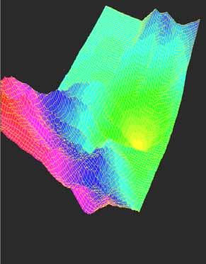
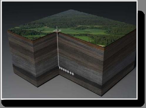
4 Rock formation located below the Austin Chalk Shale gas is an unconventional source of natural gas

5 There is a large increase in the amount of pipelines needed to support this play Though there is an existing infrastructure in place, production exceeds its capacity
6 Currently pipeline route selection is governed by the shortest path from origin to destination Route optimization needs to be used to intelligently select the best routes Proper route selection can lower the initial cost of the project, increase the life of the pipeline, and have a minimal impact on the environment


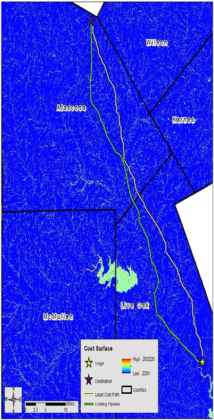
7 A Prototype for Pipeline Routing Using Remotely Sensed Data and Geographic Information System Analysis Sandra C. Feldman et al An Integrated Assessment model for cross-country pipelines Prasanta Kumar Dey Planning a Least Cost Gas Pipeline Route a GIS & SDSS Integration Approach Maheen Iqbal et at


8 Kazakhstan to Russia Sound methodology and variables Unscientific weighting criteria Narrow corridor for pipeline route Unreliable data used Restricted final route 14% less costly than the straight line path

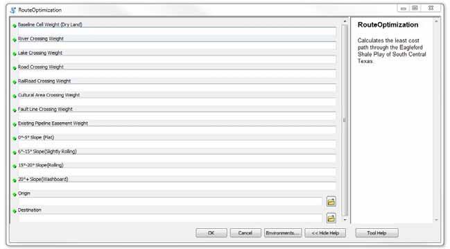
9 Great routing goals listed Good examples of poor pipeline route selection No methodology or study area listed for route selection Project feasibility not a GIS analysis paper Found the optimal route 3% cheaper than shortest route
10 Ahvaz-Marun 35km oil pipeline in SW Iran Similar least cost methodology Unrealistic weights Lacking variables Cost model run against an existing pipeline 1km longer but 29% cheaper than existing route

11 Research was only done for large mainly international pipelines Missing important variables Variable weight issues Not flexible, automated, or interactive
12 Determine the least cost path for pipelines in the Eagle Ford Shale region Creating an automated, interactive, flexible python geoprocessing tool using ESRIs arcpy site package

13 Python site package for ArcGIS 10 python scripting Great for geoprocessing tool creation and task automation


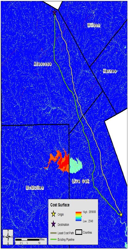
14 McMullen, Live Oak, Karnes, Atascosa, and Wilson counties
15 Variables selection Rasterize all variables Clip all variables to study area Reclassify variables for automation Write geoprocessing tool
16 Slope River crossings Lake crossings Road crossings Railroad crossings Cultural areas Fault lines Existing pipeline easements
17

18 A cost surface is created using the weights given through the UI to determine the cost to traverse each cell over the landscape Then an accumulated cost surface adds the cost of all cells from the point of origin specified in the UI The least cost path is calculated and returned as a shapefile
19 A1= (cost1 + cost2 )/2 A2=(cost2 + cost3)/2 Accumulative cost = A1 + A2 For diagonal cost A1=1.4142(Cost1 + Cost2)/2
20
21 12.2% Cheaper Saves $3.27 Million 3 miles shorter than existing pipeline 584 less road/railroad crossing cells 362 less water crossing cells 35 less fault line crossing cells
22
23 Fault line and cultural areas were removed because they do not initially add cost to the project Least cost path still stayed east of the existing pipeline. Least cost path 11.5% cheaper. Saved $2.99 Million and was 3 miles shorter at 67 total miles Existing pipeline 592 more road/railroad crossing cells, 400 more water crossing cells

24
25 A straight existing pipeline was selected to test to see if the straightest path would be the cheapest Least cost path 4.1% cheaper and $624,180 less Existing route had 64 more Road/Railroad crossing cells, 312 more river crossing cells, and 3 more fault line crossing cells Existing pipeline was 2.55 miles shorter
26 This tool successfully produces lease cost paths from the cost distance rasters created from the variable weights It is flexible for the users purpose It is automated to combine multiple steps in cost distance analysis

27 The least cost path was calculated based of the cost raster and knew where exactly to cross cells diagonally Existing pipeline rarely crossed at exact corner of a cell so it picked up the neighboring cells as well 15 Ft. Buffering was used to equalize this issue Future research needs to address this
28 This research makes route optimization easy for all users It is a quick way to begin any pipeline project. These tools can be created for any location. At small or large scales
29 Marcellus Shale Play route optimization Lidar data More Variables More in depth Interactive Web GIS
30 Feldman, S.C., R.E. Pelletier, E. Walser, J.C.Smoot and D.AHL, A prototype for pipeline routing using remotely sensed data and geographic information system analysis. Remote Sens. Environ.. 533: Iqbal, M., F. Sattar and M. Nawaz, Planning a least cost gas pipeline route a GIS an dsdss integration approach. Proceedings of thee International Conference on Advances in Space Technologies, Sept 2-3, Islamabad, Pakistan, pp: Dey PK. An integrated assessment model for cross-country pipelines. Environmental Impact Assessment Review 22(2002)

31

32 Special Thanks to Alan Wurtz, Troy Turcott, Brandon Showers and Hayley Ferri for their support of this research
GIS based high speed railway between Calgary-Red Deer-Edmonton
 Capstone Project BGIS Bachel o r of A p p l i ed Technology in G eographic I n f o r m a tion S y s tems GIS based high speed railway between Calgary-Red Deer-Edmonton Sisay Bayafers Arshdeep Virk Jordan
Computer Application in Routing of Road using Least-Cost Path Analysis in Hillside Development
 Research Journal of Environmental and Earth Sciences 4(10): 907-911, 2012 ISSN:2041-0492 Maxwell Scientific Organization, 2012 Submitted: August 07, 2012 Accepted: September 24, 2012 Published: October
Spatial Analysis with Web GIS. Rachel Weeden
 Spatial Analysis with Web GIS Rachel Weeden Agenda Subhead goes here Introducing ArcGIS Online Spatial Analysis Workflows Scenarios Other Options Resources ArcGIS is a Platform Making mapping and analytics
Visualization of Commuter Flow Using CTPP Data and GIS
 Visualization of Commuter Flow Using CTPP Data and GIS Research & Analysis Department Southern California Association of Governments 2015 ESRI User Conference l July 23, 2015 l San Diego, CA Jung Seo,
Pipeline Routing Using Geospatial Information System Analysis
 Pipeline Routing Using Geospatial Information System Analysis Mahmoud Reza 1 Delavar and Fereydoon 2 Naghibi 1-Assistance Professor, Dept. of Surveying and Geomatic Eng., Eng. Faculty, University of Tehran,
Natalie Cabrera GSP 370 Assignment 5.5 March 1, 2018
 Network Analysis: Modeling Overland Paths Using a Least-cost Path Model to Track Migrations of the Wolpertinger of Bavarian Folklore in Redwood National Park, Northern California Natalie Cabrera GSP 370
GIS BASED PIPELINE ROUTE SELECTION BY ARCGIS IN TURKEY
 GIS BASED PIPELINE ROUTE SELECTION BY ARCGIS IN TURKEY Volkan YILDIRIM A. Cagdas AYDINOGLU,Tahsin YOMRALIOGLU Karadeniz Technical University, Turkey Twenty-Seventh Annual ESRI International User Conference
GIS Analysis and Spatial Modelling for Optimal Oil Pipeline Route Location: A Case Study of Proposed Isiolo Nakuru Pipeline Route
 GIS Analysis and Spatial Modelling for Optimal Oil Pipeline Route Location: A Case Study of Proposed Isiolo Nakuru Pipeline Route Macharia Peter M 1, Charles N. Mundia 2 1 Topsurv Geosystems Limited, P.O
GIS Level 2. MIT GIS Services
 GIS Level 2 MIT GIS Services http://libraries.mit.edu/gis Email: gishelp@mit.edu TOOLS IN THIS WORKSHOP - Definition Queries - Create a new field in the attribute table - Field Calculator - Add XY Data
High Speed / Commuter Rail Suitability Analysis For Central And Southern Arizona
 High Speed / Commuter Rail Suitability Analysis For Central And Southern Arizona Item Type Reports (Electronic) Authors Deveney, Matthew R. Publisher The University of Arizona. Rights Copyright is held
Abstract: Contents. Literature review. 2 Methodology.. 2 Applications, results and discussion.. 2 Conclusions 12. Introduction
 Abstract: Landfill is one of the primary methods for municipal solid waste disposal. In order to reduce the environmental damage and to protect the public health and welfare, choosing the site for landfill
MUG Presentation. Quantifying Habitat Disturbance by Marcellus Shale Drilling Activities in Pennsylvania. Introduction. Previous Work.
 Quantifying Habitat Disturbance by Marcellus Shale Drilling Activities in Pennsylvania Dr. Chad Freed Elisabeth Powell Widener University MUG Presentation and Problem Statement GIS Data Acquisition and
Geospatial Data Solutions: Site and Corridor Siting Projects. Rachel Turney-Work
 Geospatial Data Solutions: Site and Corridor Siting Projects Rachel Turney-Work Agenda GIS-based Corridor Routing Definition Major Components Uses and Functionality Geospatial Data Sources Data Accuracy
Louisiana Transportation Engineering Conference. Monday, February 12, 2007
 Louisiana Transportation Engineering Conference Monday, February 12, 2007 Agenda Project Background Goal of EIS Why Use GIS? What is GIS? How used on this Project Other site selection tools I-69 Corridor
Visualization of Origin- Destination Commuter Flow Using CTPP Data and ArcGIS
 Visualization of Origin- Destination Commuter Flow Using CTPP Data and ArcGIS Research & Analysis Department Southern California Association of Governments 2015 ESRI User Conference l July 23, 2015 l San
Exploring the Marcellus Shale using ArcGIS 3D Analyst
 Exploring the Marcellus Shale using ArcGIS 3D Analyst Advanced GIS GEOG/ES 490 Wednesday, May 5, 2010 Matthew M. Brown Project Background The Marcellus Shale is a subsurface rock formation that has recently
The Online Environmental Assessment Form Mapping Tool
 The Online Environmental Assessment Form Mapping Tool Presented by: Austin Fisher Fountains Spatial, Inc. New York State GIS Conference Saratoga Springs November 13 th, 2013 Content Background Information
ArcGIS Pro: Analysis and Geoprocessing. Nicholas M. Giner Esri Christopher Gabris Blue Raster
 ArcGIS Pro: Analysis and Geoprocessing Nicholas M. Giner Esri Christopher Gabris Blue Raster Agenda What is Analysis and Geoprocessing? Analysis in ArcGIS Pro - 2D (Spatial xy) - 3D (Elevation - z) - 4D
A METHOD FOR PREDICTING NETWORK DISTANCE USING NETWORK SHORTEST DISTANCE AND SPATIAL INTERPOLATION
 A METHOD FOR PREDICTING NETWORK DISTANCE USING NETWORK SHORTEST DISTANCE AND SPATIAL INTERPOLATION Abdulnaser Arafat Ph.D. Student Urban and Regional Planning Supervisors: Professor Ruth Steiner Professor
Esri UC Talking Points. Harmful Algae Blooms (HABs) Rapid growth, blooming of toxin producing algae
 Rapid growth, blooming of toxin producing algae") Esri UC Talking Points Harmful Algae Blooms (HABs) Rapid growth, blooming of toxin producing algae They exist on every coast Freshwater and marine species Commented [1]: Combine for talk HAB-OFS produces
Esri UC Talking Points Harmful Algae Blooms (HABs) Rapid growth, blooming of toxin producing algae They exist on every coast Freshwater and marine species Commented [1]: Combine for talk HAB-OFS produces
Karsten Vennemann, Seattle. QGIS Workshop CUGOS Spring Fling 2015
 Karsten Vennemann, Seattle 2015 a very capable and flexible Desktop GIS QGIS QGIS Karsten Workshop Vennemann, Seattle slide 2 of 13 QGIS - Desktop GIS originally a GIS viewing environment QGIS for the
The improvement of production of the GDR50LT in Lithuania
 The improvement of production of the in Lithuania Kęstutis PAPŠYS, Lina PAPŠIENĖ, Julius D. BUDREVIČIUS, Marius MARMA, Evaldas ROŽANSKAS, Mindaugas PAŽEMYS / GIS-Centras Jurgita ŠPŪRAITĖ / National Land
Relief Camp Tool Using GIS
 Relief Camp Tool Using GIS MAYANK SINGH SAKLA 1, JANKI ADHVARYU 2 1 M.TECH GEOMATICS STUDENT, CEPT UNIVERSITY 2 M.TECH GEOMATICS STUDENT, CEPT UNIVERSITY K L CAMPUS UNIVERSITY AREA NAVARANG PURA AHMEDABAD
Spatial Analyst. By Sumita Rai
 ArcGIS Extentions Spatial Analyst By Sumita Rai Overview What does GIS do? How does GIS work data models Extension to GIS Spatial Analyst Spatial Analyst Tasks & Tools Surface Analysis Surface Creation
Laboratory Exercise - Temple-View Least- Cost Mountain Bike Trail
 Brigham Young University BYU ScholarsArchive Engineering Applications of GIS - Laboratory Exercises Civil and Environmental Engineering 2017 Laboratory Exercise - Temple-View Least- Cost Mountain Bike
King Fahd University of Petroleum & Minerals College of Engineering Sciences Civil Engineering Department. Geographical Information Systems(GIS)
") King Fahd University of Petroleum & Minerals College of Engineering Sciences Civil Engineering Department Geographical Information Systems(GIS) Term Project Titled Delineating Potential Area for Locating
King Fahd University of Petroleum & Minerals College of Engineering Sciences Civil Engineering Department Geographical Information Systems(GIS) Term Project Titled Delineating Potential Area for Locating
SPATIAL MODELING GIS Analysis Winter 2016
 SPATIAL MODELING GIS Analysis Winter 2016 Spatial Models Spatial Modeling attempts to represent how the world works All models are wrong, but some are useful (G.E. Box, quoted in course textbook pg. 379)
DATA SCIENCE SIMPLIFIED USING ARCGIS API FOR PYTHON
 DATA SCIENCE SIMPLIFIED USING ARCGIS API FOR PYTHON LEAD CONSULTANT, INFOSYS LIMITED SEZ Survey No. 41 (pt) 50 (pt), Singapore Township PO, Ghatkesar Mandal, Hyderabad, Telengana 500088 Word Limit of the
Problems and Challenges
 2018 Esri Petroleum GIS Conference Problems and Challenges May 9 10, 2018 Houston, Texas George R. Brown Convention Center Disunity of drawing standards and format Large amount of work in Cartography,
Evaluating Corridors. Jeff Jenness Dan Majka Paul Beier. CorridorDesigner Workshop Fall 2007
 Evaluating Corridors Jeff Jenness Dan Majka Paul Beier CorridorDesigner Workshop Fall 2007 1 1 Evaluating Corridors Test Alternative Corridors Least cost methods always provide a best solution, even when
Automated Map Book Production Workflow: Using ArcGIS and Python Programming
 Automated Map Book Production Workflow: Using ArcGIS and Python Programming 2018 ESRI User Conference Jung H. Seo, Tom M. Vo and Frank Wen Southern California Association of Governments July 10, 2018 San
Geographical Information Systems
 Geographical Information Systems Geographical Information Systems (GIS) is a relatively new technology that is now prominent in the ecological sciences. This tool allows users to map geographic features
Application of Geographic Information Systems for Government School Sites Selection
 Rs. 3000,00 Application of Geographic Information Systems for Government School Sites Selection by K. D. Nethsiri Jayaweera M.Sc. Library - USJP 1111111111111111 210975 2014 210873 Application of Geographic
A New Approach to Estimating Population Growth Along a Major Arterial Highway.
 . ABSTRACT In the last twenty years Texas has undergone extensive growth as people move across the country and relocate in the Lone Star State. Many of these new Texans choose suburbs outside major cities
GIS-T 2010 Building a Successful Geospatial Data Sharing Framework: A Ohio DOT Success Story
 GIS-T 2010 Building a Successful Geospatial Data Sharing Framework: A Ohio DOT Success Story ODOT District 2 GIS John Puente District 1 GIS Coordinator\ Planning Administrator 2 Interoperability 3 District
USING GIS CARTOGRAPHIC MODELING TO ANALYSIS SPATIAL DISTRIBUTION OF LANDSLIDE SENSITIVE AREAS IN YANGMINGSHAN NATIONAL PARK, TAIWAN
 CO-145 USING GIS CARTOGRAPHIC MODELING TO ANALYSIS SPATIAL DISTRIBUTION OF LANDSLIDE SENSITIVE AREAS IN YANGMINGSHAN NATIONAL PARK, TAIWAN DING Y.C. Chinese Culture University., TAIPEI, TAIWAN, PROVINCE
Long-Distance Pumping and Opportunities for Engineering with Nature
 Long-Distance Pumping and Opportunities for Engineering with Nature Tim Welp and Derek Wilson Tim Welp Research Hydraulic Engineer Coastal and Hydraulics Laboratory 23 October 2012 Engineering with Nature
THE CONSERVATION LANDSCAPE CONTEXT TOOLBOX: A Custom ESRI ArcToolbox for the Stewardship of Conservation Lands in Rhode Island
 THE CONSERVATION LANDSCAPE CONTEXT TOOLBOX: A Custom ESRI ArcToolbox for the Stewardship of Conservation Lands in Rhode Island Ann Borowik M.E.S.M. Research Project University of Rhode Island May 2008
Python Raster Analysis. Kevin M. Johnston Nawajish Noman
 Python Raster Analysis Kevin M. Johnston Nawajish Noman Outline Managing rasters and performing analysis with Map Algebra How to access the analysis capability - Demonstration Complex expressions and optimization
ArcGIS Enterprise: What s New. Philip Heede Shannon Kalisky Melanie Summers Sam Williamson
 ArcGIS Enterprise: What s New Philip Heede Shannon Kalisky Melanie Summers Sam Williamson ArcGIS Enterprise is the new name for ArcGIS for Server What is ArcGIS Enterprise ArcGIS Enterprise is powerful
Spatial Data Analysis with ArcGIS Desktop: From Basic to Advance
 Spatial Data Analysis with ArcGIS Desktop: From Basic to Advance 1. Course overview Modern environmental, energy as well as resource modeling and planning require huge amount of geographically located
GIS Software. Evolution of GIS Software
 GIS Software The geoprocessing engines of GIS Major functions Collect, store, mange, query, analyze and present Key terms Program collections of instructions to manipulate data Package integrated collection
GIS for Business Intelligence: Getting Cloud Connected
 GIS for Business Intelligence: Getting Cloud Connected Ed Farrell Director of GIS Solutions, DVG efarrell@dvginteractive.com http://dvginteractive.com October 19 th, 2017 Lake Placid Convention Center
GeoSUR SRTM 30-m / TPS
 GeoSUR SRTM 30-m / TPS Wm Matthew Cushing (USGS) 16 May 2013 U.S. Department of the Interior U.S. Geological Survey SRTM Mission Shuttle Radar Topography Mission (SRTM) Space Shuttle Endeavour during the
COMMON GIS TECHNIQUES FOR VECTOR AND RASTER DATA PROCESSING. Ophelia Wang, Department of Geography and the Environment, University of Texas
 COMMON GIS TECHNIQUES FOR VECTOR AND RASTER DATA PROCESSING Ophelia Wang, Department of Geography and the Environment, University of Texas PART I: BASIC VECTOR TOOLS CLIP A FEATURE BASED ON THE EXTENT
Watershed Delineation
 Watershed Delineation Jessica L. Watkins, University of Georgia 2 April 2009 Updated by KC Love February 25, 2011 PURPOSE For this project, I delineated watersheds for the Coweeta synoptic sampling area
DP Project Development Pvt. Ltd.
 Dear Sir/Madam, Greetings!!! Thanks for contacting DP Project Development for your training requirement. DP Project Development is leading professional training provider in GIS technologies and GIS application
How GIS can support the Production
 How GIS can support the Production of Local Development Plans ESRI User Conference 2017 Mandy Maas ARUP Who we are Shaping a better world We are an independent firm of designers, planners, engineers, consultants
Using ArcGIS Server to Bring Geospatial Analysis
 Using ArcGIS Server to Bring Geospatial Analysis and Mapping to non-gis Analysts ESRI Health User Conference September 22, 2009 Jim Laramie, Altarum Institute Sam Wang, Altarum Institute Agenda Agenda
Georeferencing the Lackawanna Synclinorium using GIS
 Georeferencing the Lackawanna Synclinorium using GIS Conservation Services, LLC 2/20/2010 Contact: Philip Pass 570.510.1758 Rick Marquardt 570-335-7525 Managing Partners: Conservation Services LLC Author:
Creating Watersheds from a DEM
 Creating Watersheds from a DEM These instructions enable you to create watersheds of specified area using a good quality Digital Elevation Model (DEM) in ArcGIS 8.1. The modeling is performed in ArcMap
NMRDSS (Nigerian Mineral Resources Decision Support System)
") NMRDSS (Nigerian Mineral Resources Decision Support System) AJAY YADAV 1, YYYYYYY 2 1 Technical Specialist, RMSI Private Limited 2 Position in the Org, Name of Organization A-8 Sector 16, Noida 201 301,
NMRDSS (Nigerian Mineral Resources Decision Support System) AJAY YADAV 1, YYYYYYY 2 1 Technical Specialist, RMSI Private Limited 2 Position in the Org, Name of Organization A-8 Sector 16, Noida 201 301,
A method for spatially simulating oil and gas footprint to test for effects of proposed developments on caribou movement
 A method for spatially simulating oil and gas footprint to test for effects of proposed developments on caribou movement Eric Neilson, Haitao Li, Tyler Muhly, Rob Serrouya, Charlene Nielsen University
ISSUES AND APPROACHES TO COUPLING GIS TO AN IRRIGATION DISTRIBUTION NETWORK AND SEEPAGE LOSS MODELS ABSTRACT
 ISSUES AND APPROACHES TO COUPLING GIS TO AN IRRIGATION DISTRIBUTION NETWORK AND SEEPAGE LOSS MODELS Yanbo Huang 1, Milton Henry 2, David Flahive 3, Guy Fipps 4 ABSTRACT Geographic Information Systems (GIS)
Flood Hazard Zone Modeling for Regulation Development
 Flood Hazard Zone Modeling for Regulation Development By Greg Lang and Jared Erickson Pierce County GIS June 2003 Abstract The desire to blend current digital information with government permitting procedures,
YYT-C3002 Application Programming in Engineering GIS I. Anas Altartouri Otaniemi
 YYT-C3002 Application Programming in Engineering GIS I Otaniemi Overview: GIS lectures & exercise We will deal with GIS application development in two lectures. Because of the versatility of GIS data models
Development of an On-Line Interactive GIS Map 1995 OAS Geology Field Trip in NE Oklahoma
 Development of an On-Line Interactive GIS Map 1995 OAS Geology Field Trip in NE Oklahoma JODIE MURRAY BURNS NORTHWEST ARKANSAS COMMUNITY COLLEGE, ROGERS, ARKANSAS FALL 2015 INDEPENDENT STUDY PROJECT PROFESSOR:
Introduction to ArcGIS Spatial Analyst
 Esri International User Conference San Diego, California Technical Workshops July 2011 Introduction to ArcGIS Spatial Analyst Steve Kopp Elizabeth Graham ArcGIS Spatial Analyst Integrated raster and vector
ISSUES AND APPROACHES TO COUPLING GIS TO IRRIGATION DISTRIBUTION NETWORK AND SEEPAGE LOSS MODELS
 ISSUES AND APPROACHES TO COUPLING GIS TO IRRIGATION DISTRIBUTION NETWORK AND SEEPAGE LOSS MODELS Yanbo Huang 1 Milton Henry 2 David Flahive 3 Guy Fipps 4 ABSTRACT There are several possible approaches
Development of statewide 30 meter winter sage grouse habitat models for Utah
 Development of statewide 30 meter winter sage grouse habitat models for Utah Ben Crabb, Remote Sensing and Geographic Information System Laboratory, Department of Wildland Resources, Utah State University
Patrick McGregor Department of Resource Analysis, Saint Mary s University of Minnesota, Minneapolis, MN 55404
 A Spatial Analysis of Cellular Tower Placement Along Cities and Highways to Determine Optimal Tower Placement Criteria Using Geographic Information Science (GIS) Patrick McGregor Department of Resource
SITE SELECTION FOR NEW DESALINATION PLANT AND PLANNING AN OPTIMAL WATER DISTRIBUTION NETWORK IN TUTICORIN TALUK
 SITE SELECTION FOR NEW DESALINATION PLANT AND PLANNING AN OPTIMAL WATER DISTRIBUTION NETWORK IN TUTICORIN TALUK *Miss.V.Sahana Devi, **Mrs.G.Devi. *PG student: Department of Civil Engineering, **Assistant
A Temporal Hydrologic Database for Rapidly Changing Landscapes
 A Temporal Hydrologic Database for Rapidly Changing Landscapes Using Mt. St. Helens in Washington as a Pilot Site Adam Mosbrucker Geog 575 BACKGROUND: Client / User U.S. Geological Survey Cascades Volcano
PROCESSING, ANALYSIS, AND DISTRIBUTION OF SHALE DATA OVER GIS SERVICES AND WEB APPS
 PROCESSING, ANALYSIS, AND DISTRIBUTION OF SHALE DATA OVER GIS SERVICES AND WEB APPS Roman Boros, Peter Pavlicko 2018 ESRI Petroleum User Conference Houston, May 10, 2018 Abstract Production of oil and
Generating Scheduled Rasters using Python
 Generating Scheduled Rasters using Python Kevin B. Cary, GISP Department of Geography and Geology Western Kentucky University 1906 College Heights Blvd #31066 Bowling Green, KY 42101 1066 July 2, 2015
Assessment of Physical status and Irrigation potential of Canals using ArcPy
 Assessment of Physical status and Irrigation potential of Canals using ArcPy Ekta Gupta 1, R.N. Sankhua 2 1 JRF, CES, Indian Institute of Science, Bangalore 2 Director, National Water Academy, Pune Abstract:
Introduction to ArcGIS Server - Creating and Using GIS Services. Mark Ho Instructor Washington, DC
 Introduction to ArcGIS Server - Creating and Using GIS Services Mark Ho Instructor Washington, DC Technical Workshop Road Map Product overview Building server applications GIS services Developer Help resources
Trail Flow: Analysis of Drainage Patterns Affecting a Mountain Bike Trail
 Andy Belcher BAE 590 Professor Huffman 12.9.11 Location Trail Flow: Analysis of Drainage Patterns Affecting a Mountain Bike Trail The location of the project area rests in the Cary area of Wake County,
Potential for Shale Gas in Georgia:
 Potential for Shale Gas in Georgia: Preliminary Study for Feasibility Analysis of Shale Gas Exploration in Georgia Prepared for: AEAI under Grant Agreement #ECI GA R2 48 Georgia Energy Capacity Initiative
Land-Use Land-Cover Change Detector
 15 th Esri India User Conference 2014 Land-Use Land-Cover Change Detector Rushikesh Padsala Email ID:- rushikesh101@gmail.com Student, III Semester, M.Tech Geomatics, Faculty of Technology, CEPT University
ArcGIS Enterprise: What s New. Philip Heede Shannon Kalisky Melanie Summers Shreyas Shinde
 ArcGIS Enterprise: What s New Philip Heede Shannon Kalisky Melanie Summers Shreyas Shinde ArcGIS Enterprise is the new name for ArcGIS for Server ArcGIS Enterprise Software Components ArcGIS Server Portal
Interoperable Services for Web-Based Spatial Decision Support
 Interoperable Services for Web-Based Spatial Decision Support Nicole Ostländer Institute for Geoinformatics, University of Münster Münster, Germany ostland@uni-muenster.de SUMMARY A growing number of spatial
Multi-scale modeling of species distributions, hydrology, & gene flow
 Multi-scale modeling of species distributions, hydrology, & gene flow Douglas R. Leasure PhD. Candidate University of Arkansas Department of Biological Sciences BIG data in GIS http://www.gap.uidaho.edu/portal/datadownload.html
Laboratory Exercise Possible Zara Locations in Utah
 Brigham Young University BYU ScholarsArchive Engineering Applications of GIS - Laboratory Exercises Civil and Environmental Engineering 2017 Laboratory Exercise Possible Zara Locations in Utah Garlick
Improved Geohazard Analysis for Drilling Favorability Maps
 Improved Geohazard Analysis for Drilling Favorability Maps Joshua T. Kelly William C. Haneberg ESRI Petroleum GIS Conference 9 April, 2015 1 Overview Section 1 Introduction to Geohazards & Favorability
Development of Webbased. Tool for Tennessee
 Development of Webbased Farm Mapping Tool for Tennessee Southern Region Water Quality Conference, Oct. 24 2005 Forbes Walker and Alan Jolly Biosystems Engineering and SOIL SCIENCE Nutrient Management Planning
ArcGIS Data Reviewer: Quality Assessment for Elevation Raster Datasets. Roslyn Dunn
 ArcGIS Data Reviewer: Quality Assessment for Elevation Raster Datasets Roslyn Dunn What is ArcGIS Data Reviewer? Data Quality Management for ArcGIS Provides - Rule-based validation - Interactive tools
Spatial Analysis with ArcGIS Pro STUDENT EDITION
 Spatial Analysis with ArcGIS Pro STUDENT EDITION Copyright 2018 Esri All rights reserved. Course version 2.0. Version release date November 2018. Printed in the United States of America. The information
Spatial Analysis of Raster Data
 Spatial Analysis of Raster Data 0 0 1 1 0 0 1 1 1 0 1 1 1 1 1 1 2 4 4 4 2 4 5 5 4 2 4 4 4 2 5 5 4 4 2 4 5 4 3 5 4 4 4 2 5 5 5 3 + = 0 = shale 1 = limestone 2 = fault 4 = no fault 2 =Fault in shale 3 =
Display data in a map-like format so that geographic patterns and interrelationships are visible
 Vilmaliz Rodríguez Guzmán M.S. Student, Department of Geology University of Puerto Rico at Mayagüez Remote Sensing and Geographic Information Systems (GIS) Reference: James B. Campbell. Introduction to
A Comprehensive Inventory of the Number of Modified Stream Channels in the State of Minnesota. Data, Information and Knowledge Management.
 A Comprehensive Inventory of the Number of Modified Stream Channels in the State of Minnesota Data, Information and Knowledge Management Glenn Skuta Environmental Analysis and Outcomes Division Minnesota
Imagery and the Location-enabled Platform in State and Local Government
 Imagery and the Location-enabled Platform in State and Local Government Fred Limp, Director, CAST Jim Farley, Vice President, Leica Geosystems Oracle Spatial Users Group Denver, March 10, 2005 TM TM Discussion
Geometric Algorithms in GIS
 Geometric Algorithms in GIS GIS Visualization Software Dr. M. Gavrilova GIS Software for Visualization ArcView GEO/SQL Digital Atmosphere AutoDesk Visual_Data GeoMedia GeoExpress CAVE? Visualization in
How does ArcGIS Server integrate into an Enterprise Environment? Willy Lynch Mining Industry Specialist ESRI, Denver, Colorado USA
 How does ArcGIS Server integrate into an Enterprise Environment? Willy Lynch Mining Industry Specialist ESRI, Denver, Colorado USA wlynch@esri.com ArcGIS Server Technology Transfer 1 Agenda Who is ESRI?
Esri Training by Microcenter Prepare to Innovate. Microcenter Course Catalog
 Esri Training by Microcenter Prepare to Innovate 2015 Instructor-Led Courses Microcenter Course Catalog ArcGIS Foundational Courses Designed to meet the learning needs of professionals whose GIS experience
CUYAHOGA COUNTY URBAN TREE CANOPY & LAND COVER MAPPING
 CUYAHOGA COUNTY URBAN TREE CANOPY & LAND COVER MAPPING FINAL REPORT M IKE GALVIN S AVATREE D IRECTOR, CONSULTING GROUP P HONE: 914 403 8959 E MAIL: MGALVIN@SAVATREE. COM J ARLATH O NEIL DUNNE U NIVERSITY
Road Network Planning for Sustainable Urban Development in Kirtipur Municipality, Nepal
 Road Network Planning for Sustainable Urban Development in Kirtipur Municipality, Nepal Bikash Kumar Karna Survey Officer, Survey Department, Min Bhawan, Kathmandu, Nepal. Abstract Road network deals with
Paper PO-27 Does SAS Distance Measurement Differ from ArcGIS Distance Measurement?
 Paper PO-27 Does SAS Distance Measurement Differ from ArcGIS Distance Measurement? Imam Xierali, American Academy of Family Physicians Abstract: Distance calculation on the surface of the earth is an important
HIGH RESOLUTION BASE MAP: A CASE STUDY OF JNTUH-HYDERABAD CAMPUS
 HIGH RESOLUTION BASE MAP: A CASE STUDY OF JNTUH-HYDERABAD CAMPUS K.Manjula Vani, Abhinay Reddy, J. Venkatesh, Ballu Harish and R.S. Dwivedi ABSTRACT The proposed work High Resolution Base map: A Case study
Introduction. Project Summary In 2014 multiple local Otsego county agencies, Otsego County Soil and Water
 Introduction Project Summary In 2014 multiple local Otsego county agencies, Otsego County Soil and Water Conservation District (SWCD), the Otsego County Planning Department (OPD), and the Otsego County
Exercise 6: Working with Raster Data in ArcGIS 9.3
 Exercise 6: Working with Raster Data in ArcGIS 9.3 Why Spatial Analyst? Grid query Grid algebra Grid statistics Summary by zone Proximity mapping Reclassification Histograms Surface analysis Slope, aspect,
Title: ArcMap: Calculating Soil Areas for Storm Water Pollution Prevention Plans Authors: Brandy Woodcock, Benjamin Byars
 Title: ArcMap: Calculating Soil Areas for Storm Water Pollution Prevention Plans Authors: Brandy Woodcock, Benjamin Byars Introduction Abstract: The use of ArcMap to calculate soil areas for storm water
Introduction INTRODUCTION TO GIS GIS - GIS GIS 1/12/2015. New York Association of Professional Land Surveyors January 22, 2015
 New York Association of Professional Land Surveyors January 22, 2015 INTRODUCTION TO GIS Introduction GIS - GIS GIS 1 2 What is a GIS Geographic of or relating to geography the study of the physical features
INVESTIGATION OF AN AHP BASED MULTI CRITERIA WEIGHTING SCHEME FOR GIS ROUTING OF CROSS COUNTRY PIPELINE PROJECTS
 24th International Symposium on on Automation & Robotics in in Construction (ISARC 2007) Construction Automation Group, I.I.T. Madras INVESTIGATION OF AN AHP BASED MULTI CRITERIA WEIGHTING SCHEME FOR GIS
Administering your Enterprise Geodatabase using Python. Jill Penney
 Administering your Enterprise Geodatabase using Python Jill Penney Assumptions Basic knowledge of python Basic knowledge enterprise geodatabases and workflows You want code Please turn off or silence cell
Classifying Access on Whitewater Wildlife Management Area Callahan Unit using GIS
 Classifying Access on Whitewater Wildlife Management Area Callahan Unit using GIS Chris Scharenbroich 1, 2 1 Department of Resource Analysis, Saint Mary s University of Minnesota, Winona, MN 55987, 2 Minnesota
Transactions on Information and Communications Technologies vol 18, 1998 WIT Press, ISSN
 STREAM, spatial tools for river basins, environment and analysis of management options Menno Schepel Resource Analysis, Zuiderstraat 110, 2611 SJDelft, the Netherlands; e-mail: menno.schepel@resource.nl
The Optimal Location for the Salton Sea Pipelines
 University of Redlands InSPIRe @ Redlands MS GIS Program Major Individual Projects Geographic Information Systems 2016 The Optimal Location for the Salton Sea Pipelines Mohammed Saleh Alzaaq University
GIS for the Non-Expert
 GIS for the Non-Expert Ann Forsyth University of Minnesota February 2006 GIS for the Non-Expert 1. Definitions and problems 2. Measures being tested in Twin Cities Walking Study Basic approach, data, variables
PROSPECT EVALUATION OF UNCONVENTIONAL PLAYS IN RUSSIA EPUG 2014
 PROSPECT EVALUATION OF UNCONVENTIONAL PLAYS IN RUSSIA EPUG 2014 Main definitions AGENDA Shale/shale play definition - Organic matter content - Thermal maturity Potential for unconventionals development