Social Values for Ecosystem Services (SolVES)
|
|
|
- Edward Boyd
- 5 years ago
- Views:
Transcription
 Team Meeting Annapolis, Maryland November 5, 2012 US Department of the Interior US Geological")
1 Social Values for Ecosystem Services (SolVES) Presented to the Chesapeake Bay Program Scientific, Technical Assessment and Reporting (STAR) Team Meeting Annapolis, Maryland November 5, 2012 US Department of the Interior US Geological Survey


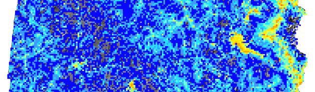
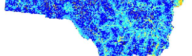
2 What is SolVES? A GIS tool for incorporating nonmonetary social value information into the spatial context of ecosystem services assessment (Sherrouse, Clement & Semmens, 2011) Calculates and maps a 10-point Value Index, which is a standardized, quantitative metric of nonmarket, stakeholder-perceived social values that often correspond to cultural ecosystem services (eg, aesthetics, recreation) ArcGIS 93 toolbar Value Index
3 What is SolVES? Derives Value Index from points mapped in a value and preference survey of stakeholders to identify locations associated with a specified social value type Models relationships between mapped Value Index and underlying environmental variables (eg, elevation, land cover, distance to roads) Goal to assist land and resource managers with analysis and communication of trade-offs


4 What is SolVES? FAVOR or OPPOSE? AESTHETIC BIODIVERSITY CULTURAL ECONOMIC FUTURE HISTORIC INTRINSIC LEARNING LIFE SUSTAINING RECREATION SPIRITUAL THERAPEUTIC
5 SolVES 20 Integrated with Maxent maximum entropy modeling software Originally developed to model geographic distribution of species using presence only data Points mapped by survey respondents analogous to points where a species was observed Environmental variables serve as constraints to be satisfied by an estimated probability distribution Higher probability = higher social value intensity
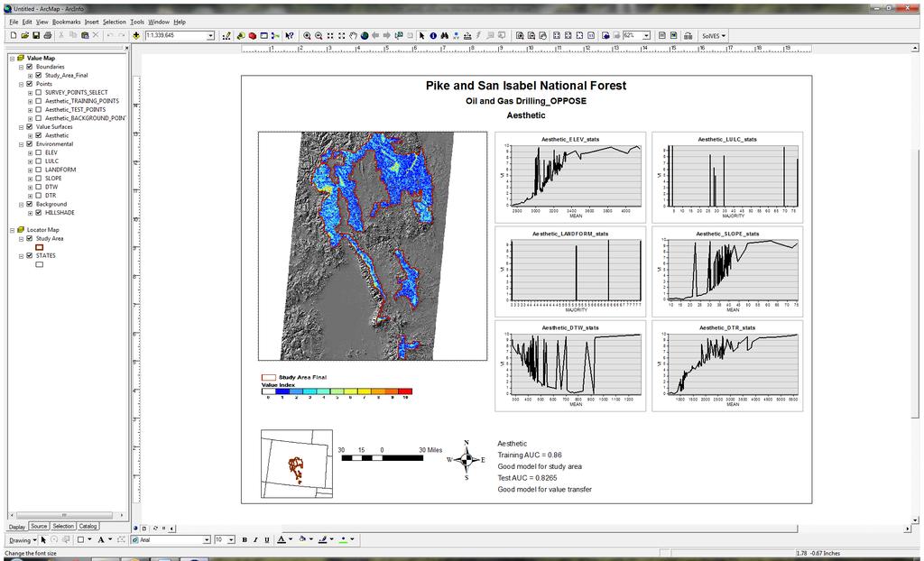
6 SolVES 20 Integrated with Maxent maximum entropy modeling software Logistic output used in conjunction with SolVES weighted kernel density output to generate social value maps that consider the points mapped by survey respondents along with the underlying environment Generates models describing relationship between points and environmental variables Calculates Area Under the Curve (AUC) statistics that can assist with evaluating model performance for the study area and its potential for value transfer
7


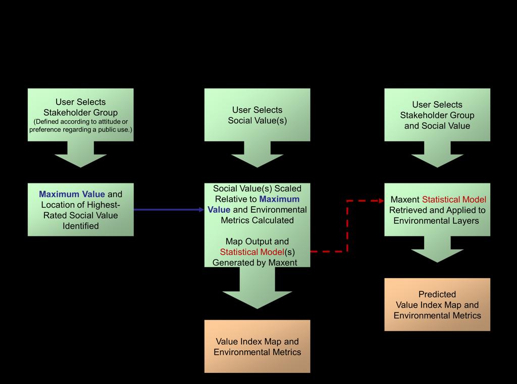
8 Ecosystem Services Social Values Model Survey Subgroup Weighted Kernel Density Maximum Weighted Density Maximum Grid Aesthetic Biodiversity Cultural Etc
9 Value Mapping Model Social Value Type Kernel Density Surface Maximum Grid Standardize Kernel Density Value Index (0 10) Value Index Maximum Survey Points X Logistic Output (0 1) Standardize Final Value Index (0 10) Zonal Statistics Environmental Layers Environmental Metrics (Average, Dominance) Environmental Layers MAXENT Models (lambdas files) Processing Instructions
10
11 Public use Communication sites and utility easements Logging for fuels reduction Logging for increased water collection Logging for wood products Motorized recreation Oil and gas drilling Attitude or preference Aesthetic Biodiversity Future Life Sustaining Recreation Therapeutic Favor or strongly favor Oppose or strongly oppose Favor or strongly favor Oppose or strongly oppose Favor or strongly favor Oppose or strongly oppose Favor or strongly favor Oppose or strongly oppose Favor or strongly favor Oppose or strongly oppose Favor or strongly favor Oppose or strongly oppose All surveys a N/A a Values are for all surveys regardless of public use, attitude or preference From Sherrouse, Clement & Semmens (2011)
12 Value Transfer Generate models describing relationship between Value Index and environmental variables in areas where survey data are available Apply models in socially and physically similar areas where no survey data are available

13
14 Future Research and Development Continue to pursue opportunities to apply and test the tool where spatially explicit social value information can be followed through to management decisions in both terrestrial and marine environments Identify environmental variables that better describe ecosystems and improve modeling of social values in a variety of environments Evaluate how SolVES results compare to and complement more traditional statistical methods of social survey data analysis Validate value transfer functionality in other selected study areas where primary data are available Address compatibility with ArcGIS 10x SolVES 21 Web-based tool?

15 solvescrusgsgov Ben Sherrouse
A Comparison of the Social Valuation of Ecosystem Services in Urban and Rural Contexts
 A Comparison of the Social Valuation of Ecosystem Services in Urban and Rural Contexts Jarrod L. Loerzel College of Charleston Zachary D. Cole University of Florida Presentation Map 1. What is SolVES?
DWH Restoration Funding at a Glance
 NCER 2018 DWH Restoration Funding at a Glance Natural Resource Damage Assessment: $8.1 Billion RESTORE Act: $5.3 Billion National Fish and Wildlife Foundation GEBF: $2.5 Billion National Academy of Sciences:
CITIZEN SCIENCE GIS: COLLABORATING WITH COMMUNITIES TO INVESTIGATE MARINE DEBRIS IN HOPKINS, BELIZE
 CITIZEN SCIENCE GIS: COLLABORATING WITH COMMUNITIES TO INVESTIGATE MARINE DEBRIS IN HOPKINS, BELIZE Michelle Chang, Rachel Layko, Chinonso Uzowihe, Erin Butler, Rigoberto Garcia Von Saqui, Lain Graham,
Overview of Methods. Terrestrial areas that are most important for conservation Conservation
 Overview of Methods The goal of the Western Lake Erie Coastal Conservation Vision project (WLECCV) is to define where we should be working locally to optimally achieve regional conservation impact. The
WELCOME & INTRODUCTION
 MPA Management Capacity Building Training Module 1: WELCOME & INTRODUCTION Participants Distinguished Guests Welcome Site Overviews of MPAs represented Overview of Training Program What are Today s Objectives?
Joanne N. Halls, PhD Dept. of Geography & Geology David Kirk Information Technology Services
 Joanne N. Halls, PhD Dept. of Geography & Geology David Kirk Information Technology Services Geographic Information Systems manage and analyze data to solve spatial problems. Real World Abstraction Analysis
SPLAN-Natura Towards an integrated spatial planning approach for Natura th January, 2017 Brussels. Commissioned by DG Environment
 SPLAN-Natura 2000 Towards an integrated spatial planning approach for Natura 2000 Commissioned by DG Environment 17 th January, 2017 Brussels V. Simeonova (Ph.D.) Drivers towards integrating Biodiversity
Spatial Decision-Support for National Marine Conservation Areas in the Southern Strait of Georgia and Gwaii Haanas
 Spatial Decision-Support for National Marine Conservation Areas in the Southern Strait of Georgia and Gwaii Haanas Lindsay McBlane Krista Royle Greg MacMillan Photo: Mark Hiebert Western and Northern Service
Marine Spatial Planning as an important tool for implementing the MSFD
 Marine Spatial Planning as an important tool for implementing the MSFD Risto Kalliola Tallinn, Nov. 16 th 2012 DEPARTMENT OF GEOGRAPHY AND GEOLOGY University of Turku, Finland Ten principles to provide
NetRA Resources Assessment (NetRA) 1
 1") NetRA Resources Assessment (NetRA) 1 Dadhi Ram Adhikari Economist 2 Christopher Babis -Water Resources Policy Richard L. Bernknopf- Economist Craig D. Broadbent- Economist David S. Brookshire- Economist
NetRA Resources Assessment (NetRA) 1 Dadhi Ram Adhikari Economist 2 Christopher Babis -Water Resources Policy Richard L. Bernknopf- Economist Craig D. Broadbent- Economist David S. Brookshire- Economist
Quantifying and Valuing Floodplain Nutrient and Sediment Retention
 Quantifying and Valuing Floodplain Nutrient and Sediment Retention Krissy Hopkins, Dianna Hogan, Emily Pindilli, Greg Noe, Fabiano Franco, and Stephanie Gordon A Community on Ecosystem Services December
Moreton Bay and Key Geographic Concepts Worksheet
 Moreton Bay and Key Geographic Concepts Worksheet The Australian Curriculum: Geography draws on seven key geographic concepts: place scale space environment change interconnection sustainability They are
Grade 2 Social Studies
 Grade 2 Social Studies Social Studies Grade(s) 2nd Course Overview This course provides an opportunity for students to explore their community and how communities operate. Scope And Sequence Timeframe
EcoServ-GIS. EcoServ GIS Stage I. Why EcoServ GIS? 17/12/2012
 EcoServ-GIS Ecosystem Services Mapping: A Wildlife Trust GIS Toolkit to map ecosystem services at a county scale Dr Jonathan Winn Living Landscape Coordinator Durham Wildlife Trust Dr Chloe Bellamy Ecosystem
MARINE STUDIES (MARINE SPATIAL PLANNING & MANAGEMENT) MASTER S DEGREE
 MASTER S DEGREE") MARINE STUDIES (MARINE SPATIAL PLANNING & MANAGEMENT) MASTER S DEGREE Influence, lead and provide decision making support for the management and planning of coastal and marine spaces. PROGRAM DESCRIPTION
MARINE STUDIES (MARINE SPATIAL PLANNING & MANAGEMENT) MASTER S DEGREE Influence, lead and provide decision making support for the management and planning of coastal and marine spaces. PROGRAM DESCRIPTION
Assessment and valuation of Ecosystem Services for decision-makers
 Assessment and valuation of Ecosystem Services for decision-makers An introduction to the ARIES approach Ferdinando Villa *, Ken Bagstad Gary Johnson, Marta Ceroni *Basque Center for Climate Change, Bilbao,
BURGAS CASE STUDY: LAND-SEA INTERACTIONS. Dr. Margarita Stancheva
 BURGAS CASE STUDY: LAND-SEA INTERACTIONS Dr. Margarita Stancheva Name of presentation NEED FOR COHERENCE BETWEEN LAND AND SEA ACTIVITIES Name presenter Burgas is the fourth largest city in Bulgaria and
EcoServ-GIS. Ecosystem Services Mapping: A Wildlife Trust GIS Toolkit to map ecosystem services at a county scale
 EcoServ-GIS Ecosystem Services Mapping: A Wildlife Trust GIS Toolkit to map ecosystem services at a county scale Dr Jonathan Winn Living Landscape Coordinator Durham Wildlife Trust Dr Chloe Bellamy Ecosystem
file://q:\report1\greenatlasfinalreportindex.html
 Page 1 of 8 Quick Links WATER MANAGEMENT INTERNSHIP USDA HIS GRANT FUNDED FINAL PROJECT REPORT SUBMITTED BY MELISSA QUINTANA 11/07/07-03/24/08 Summary Provided is an assessment of my accomplishments for
Application of Geographic Information Systems for Government School Sites Selection
 Rs. 3000,00 Application of Geographic Information Systems for Government School Sites Selection by K. D. Nethsiri Jayaweera M.Sc. Library - USJP 1111111111111111 210975 2014 210873 Application of Geographic
REPORT ON INVESTMENTS
 REPORT ON INVESTMENTS D.T2.3.3 Investments for technical equipment for the implementation of Web-GIS platform in Mantova 1 Local support group designing Mantova Web-GIS platform. Picture by Maria Giulia
Least-Cost Transportation Corridor Analysis Using Raster Data.
 Least-Cost Transportation Corridor Analysis Using Raster Data What is GeoMedia Grid: Key Grid Concepts Vector Model Vector based systems show data by means of a series of points, lines, and polygons. Each
Michigan State University, East Lansing, MI USA. Lansing, MI USA.
 On-line Supporting Information for: Using Cost-Effective Targeting to Enhance the Efficiency of Conservation Investments in Payments for Ecosystem Services Xiaodong Chen1,*, Frank Lupi2, Andrés Viña1,
Marine Spatial Planning: A Tool for Implementing Ecosystem-Based Management
 Marine Spatial Planning: A Tool for Implementing Ecosystem-Based Management Steven Murawski, Ph.D., Ecosystem Goal Team Lead National Oceanic and Atmospheric Administration NOAA November 16, 2009 1 To
16540/14 EE/cm 1 DG E 1A
 Council of the European Union Brussels, 5 December 2014 (OR. en) 16540/14 ENV 965 CULT 139 NOTE From: To: Subject: General Secretariat of the Council Delegations Charter of Rome on Natural and Cultural
Chapter 1: Introduction to Safety and Ethics
 Core Curriculum Standards Met by Each Chapter On the Right Trail meets Utah s Social Studies Core Curriculum Standards for grades 3-7. Each chapter has specific standard objectives, which are met by the
Content Area: Social Studies Standard: 1. History Prepared Graduates: Develop an understanding of how people view, construct, and interpret history
 Standard: 1. History Develop an understanding of how people view, construct, and interpret history 1. Organize and sequence events to understand the concepts of chronology and cause and effect in the history
Regional Plan 4: Integrating Ecosystem Services Mapping into Regional Land Use Planning
 Rural-Urban Outlooks: Unlocking Synergies (ROBUST) ROBUST receives funding from the European Union s Horizon 2020 research and innovation programme under grant agreement No 727988.* October 2018 Natural
How to make the European landscape climate-change proof for biodiversity? Prof. Paul Opdam
 How to make the European landscape climate-change proof for biodiversity? Prof. Paul Opdam Notions Habitat fragmentation and land use prevent species to respond to climate change Adaptation of the landscape
Lesson Plan 3 Land Cover Changes Over Time. An Introduction to Land Cover Changes over Time
 An Introduction to Land Cover Changes over Time This lesson plan builds on the lesson plan on Understanding Land Use and Land Cover Using Google Earth. Please refer to it in terms of definitions on land
Geographical knowledge and understanding scope and sequence: Foundation to Year 10
 Geographical knowledge and understanding scope and sequence: Foundation to Year 10 Foundation Year 1 Year 2 Year 3 Year 4 Year 5 Year 6 Year level focus People live in places Places have distinctive features
Millennium Ecosystem Assessment
 Millennium Ecosystem Assessment Global Data Challenges from an MA perspective Global Spatial Data and Information User Workshop 21-23 September 2004! What is the MA?! How and what kinds of data does it
Fig 1. Steps in the EcoValue Project
 Assessing the Social and Economic Value of Ecosystem Services in the Northern Forest Region: A Geographic Information System (GIS) Approach to Landscape Valuation Principal Investigator(s): Dr. Matthew
RANGE SUSTAINABILITY GIS APPLICATIONS AND ENTERPRISE IMPLEMENTATIONS
 RANGE SUSTAINABILITY GIS APPLICATIONS AND ENTERPRISE IMPLEMENTATIONS May 4, 2009 Gabe Lovasz, Geospatial Analyst, ManTech SRS Molly Rodriguez, Geospatial Analyst, ManTech SRS -In Support of- The Office
Seymour Centre 2017 Education Program 2071 CURRICULUM LINKS
 Suitable for: Stage 5 Stage 6 HSC Subject Links: Seymour Centre 2017 Education Program 2071 CURRICULUM LINKS Science Stage Content Objective Outcomes Stage 5 Earth and Space ES3: People use scientific
RANGE SUSTAINABILITY GIS APPLICATIONS AND ENTERPRISE IMPLEMENTATIONS
 RANGE SUSTAINABILITY GIS APPLICATIONS AND ENTERPRISE IMPLEMENTATIONS May 4, 2009 Gabe Lovasz, Geospatial Analyst, ManTech SRS Molly Rodriguez, Geospatial Analyst, ManTech SRS -In Support of- The Office
Outline. - Background of coastal and marine conservation - Species distribution modeling (SDM) - Reserve selection analysis. - Results & discussion
 - Reserve selection analysis. - Results & discussion") Application of GIS for data preparation and modeling for coastal and marine conservation planning in Madagascar Rija Rajaonson Technical Assistant, REBIOMA Wildlife Conservation Society Madagascar Outline
Application of GIS for data preparation and modeling for coastal and marine conservation planning in Madagascar Rija Rajaonson Technical Assistant, REBIOMA Wildlife Conservation Society Madagascar Outline
STUDY GUIDE. Exploring Geography. Chapter 1, Section 1. Terms to Know DRAWING FROM EXPERIENCE ORGANIZING YOUR THOUGHTS
 For use with textbook pages 19 22. Exploring Geography Terms to Know location A specific place on the earth (page 20) absolute location The exact spot at which a place is found on the globe (page 20) hemisphere
Mapping ecosystem services provided by benthic habitats in the European Atlantic Ocean
 Mapping and Assessment Ecosystem Services and Links to Good Environmental Status Mapping ecosystem services provided by benthic habitats in the European Atlantic Ocean Ibon Galparsoro, Angel Borja and
Haida Gwaii Queen Charlotte Islands
 Haida Gwaii Queen Charlotte Islands H E R I T A G E T O U R I S M STRATE GY January 2003 Haida Gwaii/Queen Charlotte Islands Heritage Tourism Strategy Working Group The Haida Gwaii/Queen Charlotte Islands
Assessing Cultural Ecosystem Services using GIS-Based Landscape Values Mapping. Case Study: Olympic Peninsula Human Ecology Mapping Project
 Portland State University PDXScholar Institute for Sustainable Solutions Publications and Presentations Institute for Sustainable Solutions 10-25-2013 Assessing Cultural Ecosystem Services using GIS-Based
How GIS based Visualizations Support Land Use and Transportation Modeling
 How GIS based Visualizations Support Land Use and Transportation Modeling ESRI International Users Conference San Diego, CA - July 23, 2015 Prepared by: Troy Hightower Introduction This presentation will
Geospatial Decision Support Tools for Planning of Marine Protected Areas in California
 Geospatial Decision Support Tools for Planning of Marine Protected Areas in California WILL MCCLINTOCK (UNIVERSITY OF CALIFORNIA SANTA BARBARA), MATT MERRIFIELD (THE NATURE CONSERVANCY), SOPHIE DE BEUKELAER
Land Use Methods & Metrics Development Outcome
 Quarterly Progress Meeting November 15, 2018 Land Use Methods & Metrics Development Outcome Peter Claggett, USGS LUWG Coordinator Through the Chesapeake Bay Watershed Agreement, the Chesapeake Bay Program
SPATIAL AND TEMPORAL MODELLING OF ECOSYSTEM SERVICES
 SPATIAL AND TEMPORAL MODELLING OF ECOSYSTEM SERVICES Solen Le Clec h, T.Decaëns, S. Dufour, M. Grimaldi, N. Jégou and J. Oszwald ACES Conference 2016 Jacksonville, Florida (USA). December, 5-9th : issues
STATE GEOGRAPHIC INFORMATION DATABASE
 STATE GEOGRAPHIC INFORMATION DATABASE Data Information and Knowledge Management STATE GEOGRAPHIC INFORMATION DATABASE EXECUTIVE SUMMARY Utah has developed one of the most comprehensive statewide GIS resources
ESSENTIAL CONCEPTS AND SKILL SETS OF THE IOWA CORE CURRICULUM
 ESSENTIAL CONCEPTS AND SKILL SETS OF THE IOWA CORE CURRICULUM SOCIAL STUDIES PROVIDED BY THE IOWA DEPARTMENT OF EDUCATION INTRODUCTION Social studies is the integrated study of the social sciences and
Geography. Geography A. Curriculum Planner and Skills Mapping Grid GCSE Version 1 October 2012
 Geography GCSE 2012 Geography A Curriculum Planner and Skills Mapping Grid Version 1 October 2012 www.ocr.org.uk/gcse2012 Year 10 Exam work Controlled Assessment Autumn 1 Autumn 2 Spring 1 Spring 2 Summer
ESPON support for Targeted Analyses Ilona Raugze Director
 ESPON support for Targeted Analyses Ilona Raugze Director ESPON EGTC 14 November 2017 ESPON EGTC workshop Targeted Analysis in support of better policy making in cities and regions Inspire policy making
The UN-GGIM: Europe core data initiative to encourage Geographic information supporting Sustainable Development Goals Dominique Laurent, France
 INSPIRE conference Strasbourg 6 September 2017 The UN-GGIM: Europe core data initiative to encourage Geographic information supporting Sustainable Development Goals Dominique Laurent, France Introduction
Academy of Finland Arctic Research Programme. Helsinki
 Academy of Finland Arctic Research Programme HENVI Seminar Helsinki 26.2.2014 Tuula Aarnio Public research funding in Finland Government research expenditure 2013 Total 2 billion Source: Statistics Finland
Resolution XIII.23. Wetlands in the Arctic and sub-arctic
 13th Meeting of the Conference of the Contracting Parties to the Ramsar Convention on Wetlands Wetlands for a Sustainable Urban Future Dubai, United Arab Emirates, 21-29 October 2018 Resolution XIII.23
Applying Health Outcome Data to Improve Health Equity
 Applying Health Outcome Data to Improve Health Equity Devon Williford, MPH, Health GIS Specialist Lorraine Dixon-Jones, Policy Analyst CDPHE Health Equity and Environmental Justice Collaborative Mile High
Spatial Data Approaches to Improve Production and Reduce Risks of Impacts
 Spatial Data Approaches to Improve Production and Reduce Risks of Impacts Geospatial & Geostatistical Analyses to Improve Science-Based Decision Making Kelly Rose, Geology & Geospatial Research Lead Jennifer
Climate Change: How it impacts Canadians and what we can do to slow it down.
 Climate Change: How it impacts Canadians and what we can do to slow it down. Lesson Overview This lesson takes stock of how climate change has already affected Canadians in geographic, economic, and cultural
Tools for Climate Change Adaptation Planning
 Adaptation base for Planning Tool (ADAPT) CRiSTAL (Community-based Risk Screening Tool Adaptation and Livelihoods) NOAA CSC Coastal Inundation Toolkit NOAA CSC Roadmap Ecosystem-Based Managment Tools Network
for Western Canada Coalbed Methane (CBM) Geoff Ryder, Melanie Luinstra Nexen Inc.
 Geoff Ryder, Melanie Luinstra Nexen Inc.") Using GIS and Data Mining for Western Canada Coalbed Methane (CBM) Exploration Geoff Ryder, Melanie Luinstra Nexen Inc. About Nexen Canadian energy company Head office in Calgary Canadian Occidental Petroleum
Using GIS and Data Mining for Western Canada Coalbed Methane (CBM) Exploration Geoff Ryder, Melanie Luinstra Nexen Inc. About Nexen Canadian energy company Head office in Calgary Canadian Occidental Petroleum
BACKGROUND INFORMATION DOCUMENT
 Strategic Environmental Assessment of the SKA Phase 1 in South Africa BACKGROUND INFORMATION DOCUMENT www.skaphase1.csir.co.za SKAPhase1@csir.co.za Introduction The MeerKAT and SKA projects are part of
National SDG Data Hubs: Statistical integration and geographic disaggregation (Philippines)
") National SDG Data Hubs: Statistical integration and geographic disaggregation (Philippines) 5 th High Level Forum on United Nations Global Geospatial Information Management Implementing the Sustainable
National SDG Data Hubs: Statistical integration and geographic disaggregation (Philippines) 5 th High Level Forum on United Nations Global Geospatial Information Management Implementing the Sustainable
Mapping and Assessment of Ecosystems and their Services
 Mapping and Assessment of Ecosystems and their Services ALTER-Net Conference 2013: Science underpinning the EU 2020 Biodiversity Strategy. April 2013 Gent Joachim MAES 1 This presentation is based on the
3/29/11. Why bother with tools? Incorporating Decision Support Tools into Climate Adaptation Planning. A Simplified Planning Process
 Incorporating Decision Support Tools into Climate Adaptation Planning Why bother with tools? Tools don t eliminate complexity but they can help deal with it" Tools can:"! Help incorporate science into
23. SUBSISTENCE USES AND TRADITIONAL KNOWLEDGE
 23. SUBSISTENCE USES AND TRADITIONAL KNOWLEDGE 23.1 Introduction The purpose of the subsistence uses and traditional knowledge study is to establish a description of subsistence uses and knowledge of local
Correlation of Neighborhood Map Machine to Grade 1 Ontario Social Studies Curriculum
 Correlation of to Grade 1 Ontario Curriculum Related Concepts of Strand A. Heritage and Identity: Our Changing Roles and Responsibilities A1. describe some of the ways in which Continuity and people s
Outline National legislative & policy context Regional history with ESSIM ESSIM Evaluation Phase Government Integration via RCCOM Regional ICOM Framew
 What MSP Implementation could change in the Maritimes Region Tim Hall, Regional Manager Oceans and Coastal Management Division Ecosystem Management Branch Fisheries and Oceans Canada Maritimes Region BIO
PENNSYLVANIA ACADEMIC STANDARDS
 PENNSYLVANIA ACADEMIC STANDARDS ARTS AND HUMANITIES 9.2 Historical and Cultural Contexts A. Explain historical, cultural and social context of an individual work in the arts B. Relate works in the arts
Cross-border Maritime Spatial Plan for the Black sea - Romania and Bulgaria project
 Cross-border Maritime Spatial Plan for the Black sea - Romania and Bulgaria project in Romania and Bulgaria Plan Presentation A first step in the management of the marine areas of Romania and Bulgaria
MIDDLE TENNESSEE STATE UNIVERSITY Global Studies / Cultural Geography Major Matrix Page 1 of 7
 Page 1 of 7 I. Social Studies Core GS 4990 (3) Senior Seminar in Global Studies SSC 1. Demonstrate critical thinking in the social sciences by GEOG 2000 (1/3) Introduction to Regional Geography posing
POPULATION DEMOGRAPHICS IN DOG RIVER WATERSHED OVER TIME
 POPULATION DEMOGRAPHICS IN DOG RIVER WATERSHED OVER TIME Kal-El Q. Waters-Jones, Department of Earth Sciences, University of South Alabama, Mobile, AL 36688. E-mail: kwatersjones@yahoo.com. Over time,
EUSAIR on sea topics from Slovenian perspective
 MINISTRY OF FOREIGN AFFAIRS REPUBLIC OF SLOVENIA EUSAIR on sea topics from Slovenian perspective Mag. Andreja Jerina National Coordinator 4 EU MRS: 270 millions of population 19 MS 12 non MS Sea basin
Contents: LEVANTE DE ALMERÍA A INFORMATION SYSTEM OBJECTIVES AND ACTIONS GEOGRAPHIC INFORMATION SYSTEM RESULTS
 Contents: LEGAL FRAMEWORK: BARCELONA CONVENTION AND ICZM PROTOCOL; COASTAL AREAS MANAGEMENT PROGRAMME; CAMP LEVANTE DE ALMERIA; OVERALL AIM AND KEY IDEAS AREA PHASES PROJECT STRUCTURE ACTIVITIES INSTITUTIONAL
Ecological Valuation for Land Use Planning Decision Support in South Florida: The Ecosystem Portfolio Model
 Ecological Valuation for Land Use Planning Decision Support in South Florida: The Ecosystem Portfolio Model Bill Labiosa, Rich Bernknopf, Paul Hearn, Dianna Hogan, Dave Strong, Leonard Pearlstine, Amy
Ecosystems. Characteristics of the Arctic Biome
 Ecosystems Characteristics of the Arctic Biome Section outline Characteristics of the climate, plants, animals and soils of the Arctic tundra biome Interrelationships between the climate, plants, animals
ESTIMATING THE SOCIAL & ENVIRONMENTAL EFFECTS OF ADVENTURE TOURISM AND RECREATION ON CROWN LAND IN BRITISH COLUMBIA
 ESTIMATING THE SOCIAL & ENVIRONMENTAL EFFECTS OF ADVENTURE TOURISM AND RECREATION ON CROWN LAND IN BRITISH COLUMBIA Wolfgang Haider School of Resource and Environmental Mgt. Simon Fraser University Burnaby,
THE SEVILLE STRATEGY ON BIOSPHERE RESERVES
 THE SEVILLE STRATEGY ON BIOSPHERE RESERVES 1 VISION FOR BIOSPHERE RESERVES IN THE 21 ST CENTURY The international Seville Conference on Biosphere Reserves, organised by UNESCO, adopted a two-pronged approach,
How important is to be a Biosphere Reserve of UNESCO? The case of Berlenga Islands (Peniche Portugal)
") How important is to be a Biosphere Reserve of UNESCO? The case of Berlenga Islands (Peniche Portugal) Sérgio Leandro Environmental advisor Township of Peniche (Portugal) Polytecnic Institute of Leiria
How important is to be a Biosphere Reserve of UNESCO? The case of Berlenga Islands (Peniche Portugal) Sérgio Leandro Environmental advisor Township of Peniche (Portugal) Polytecnic Institute of Leiria
1 Complementary Access Tools
 ENERGY IHS AccuMap Shaped by industry and powered by IHS Markit information, AccuMap is a powerful and intuitive interpretation solution for the Canadian Energy Industry. 1 Complementary Access Tools AccuLogs
The Role of Wilderness in Climate Change Adaptation
 The Role of Wilderness in Climate Change Adaptation A Case Study of the Northern Rockies Greg Aplet, Bo Wilmer Goal: Sustaining Ecosystem Services Sustaining the full suite of benefits we receive from
Experiences and Directions in National Portals"
 FIG Seminar on e-land Administration Innsbruck/Austria 2-4 June 2004 "ESRI's Experiences and Directions in National Portals" Kevin Daugherty Cadastral/Land Records Manager ESRI Topic Points Technology
Integrated approaches to the implementation of the Convention on Biological Diversity
 Integrated approaches to the implementation of the Convention on Biological Diversity Actions on ABS in the context of UNESCO Biosphere Reserves Vibeke Jensen, Director UNESCO Liaison Office in New York
New York State Learning Standards and Core Curriculum Science Grade: 3 - Adopted: Interdependent Relationships in Ecosystems
 Main Criteria: New York State Learning Standards and Core Curriculum Secondary Criteria: Subjects: Science, Social Studies Grade: 3 Correlation Options: Show Correlated New York State Learning Standards
Project Primary Contact: Gregg Servheen, Idaho Department of Fish and Game, PO Box 25 Boise, ID ,
 Project Title: Idaho Montana Divide Project Objective: Pilot the conceptualization and coordination of a transboundary Decision Support System(DSS) for fish, wildlife, and habitats along the Idaho Montana
Modeling Smart Growth in the Southeast Using Smart-SLEUTH. November 20, 2014 SOUTH ATLANTIC LCC WEB FORUM Monica A. Dorning
 Modeling Smart Growth in the Southeast Using Smart-SLEUTH November 20, 2014 SOUTH ATLANTIC LCC WEB FORUM Monica A. Dorning (Sub)Urbanization in the Southeast November 20, 2014 SOUTH ATLANTIC LCC WEB FORUM
Applying GIS to Coastal Management in Cork Harbour: the Corepoint experience
 Applying GIS to Coastal Management in Cork Harbour: the Corepoint experience Kathrin Köpke University College Cork, Ireland Thematic Conference: THE WATERFRONT MANAGEMENT AND GI (IT), 14 th -18 th November
Cultural Routes of the Council of Europe - Glossary
 Cultural Routes of the Council of Europe - Glossary Below is a collection of terms linked to Cultural Routes of the Council of Europe. The glossary is taken from the book Cultural Routes management: from
Hydrologic Analysis for Ecosystem Restoration
 Hydrologic Analysis for Ecosystem Restoration Davis, California Objectives: To provide participants with: 1) an understanding of the issues in restoration studies; 2) an overview of Corps policies and
The City of Houston is committed to work in partnership with the community to promote and protect the health and social well being of Houstonians
 Integrating GIS in Decision Making y from the Process: A Case Study City of Houston, Texas Riju Stephen MS Brenda Reyes, MD, MPH MS MBA Ketan Inamdar Inamdar, MS, Mark Perry MPH Office of Surveillance
World Geography. WG.1.1 Explain Earth s grid system and be able to locate places using degrees of latitude and longitude.
 Standard 1: The World in Spatial Terms Students will use maps, globes, atlases, and grid-referenced technologies, such as remote sensing, Geographic Information Systems (GIS), and Global Positioning Systems
Grade 6 Social Studies
 Grade 6 Social Studies Social Studies Grade(s) 6th Course Overview This course focuses on the five Wisconsin Model Academic standards for Social Studies: Geography, History, Political Science and Citizenship,
Global Environment Facility - Integrating Watershed & Coastal Areas Management (GEF-IWCAM): Andros Demonstration Site
: Andros Demonstration Site") Global Environment Facility - Integrating Watershed & Coastal Areas Management (GEF-IWCAM): Andros Demonstration Site Coastal Aquifer Management in Small Island Developing States of the Caribbean: Challenges
Global Environment Facility - Integrating Watershed & Coastal Areas Management (GEF-IWCAM): Andros Demonstration Site Coastal Aquifer Management in Small Island Developing States of the Caribbean: Challenges
Great Native American Nations
 Great Native American Nations Episode 1 Episode 2 Episode 3 Episode 4 Episode 5 Episode 6 Cheyenne: Indians of the Plains Iroquois: Indians of the Northeast Lakota Sioux: Indians of the Plains Navajo:
World Geography Review Syllabus
 Purpose Class: World Geography Review Syllabus This course is designed to help students review and remediate their understanding major themes, concepts, and facts connected to the study World Geography.
HISTORY 1XX/ DH 1XX. Introduction to Geospatial Humanities. Instructor: Zephyr Frank, Associate Professor, History Department Office: Building
 HISTORY 1XX/ DH 1XX Introduction to Geospatial Humanities Instructor: Zephyr Frank, Associate Professor, History Department Office: Building 200-332 Course Description This course introduces undergraduate
Expanding Canada s Rail Network to Meet the Challenges of the Future
 Expanding Canada s Rail Network to Meet the Challenges of the Future Lesson Overview Rail may become a more popular mode of transportation in the future due to increased population, higher energy costs,
HOLY CROSS CATHOLIC PRIMARY SCHOOL
 HOLY CROSS CATHOLIC PRIMARY SCHOOL Geography Policy Date Implemented Jan 17 Review Date Jan 22 Mission Statement Holy Cross Primary School is a Catholic School. We seek to provide a broad, balanced Christian
I CAN DO sheets Southchurch High School
 Rate your confidence in the following topic content and geographical skills by ticking the appropriate column beside each point: Red = Not confident Yellow = Almost there Green = Confident Changing landscapes
Marine/Maritime Spatial Planning Andrej Abramić
 Marine/Maritime Spatial Planning Andrej Abramić EcoAqua SUMMER SCHOOL: Ecosystem approach to aquaculture 26-29th of October 2015 Research and Technology to enhance excellence in Aquaculture development
Rainforests and Deserts: Distribution, Uses, and Human Influences. Teacher s Masters California Education and the Environment Initiative
 E Teacher s Masters California Education and the Environment Initiative Earth Science Standard E.5.e. Rainforests and Deserts: Distribution, Uses, and Human Influences California Education and the Environment
Mapping Maine s Working Waterfront: for Our Heritage and Economy
 Mapping Maine s Working Waterfront: for Our Heritage and Economy Abstract Mapping Maine s Working Waterfronts is a collaborative project led by the Island Institute that inventories the state s current
BURGAS CASE STUDY: LAND-SEA INTERACTIONS
 BURGAS CASE STUDY: LAND-SEA INTERACTIONS Dr. Margarita Stancheva IO-BAS, Bulgaria Name of presentation CROSS BORDER MARITIME SPATIAL PLANNING IN THE BLACK SEA ROMANIA AND BULGARIA (MARSPLAN BS) Project