Modernising the Northern Territory s GRS
|
|
|
- Marshall Lynch
- 5 years ago
- Views:
Transcription
1 Modernising the Northern Territory s GRS Geospatial & GNSS CORS Forum Kuala Lumpur, Malaysia Amy Peterson; Rob Sarib DIPL Land Information Survey Services Sunday 16 October 2016
2 Presentation Outline Our Jurisdiction The Northern Territory Our Department The NT Geospatial Reference System What it is used for A modernised GRS Why? How? Infrastructure, Systems
3 Facts & Figures Northern Territory - Australia


4 Population 244,307 People Employment 98,916 Jobs Gross Regional Product $ Billion
 It is estimated that 98,916 people work in NT Land area -")

5 Northern Territory Facts & Figures 1 of 8 jurisdictions in Australia Capital city - Darwin Population ~ (only 1% of the Australian population) It is estimated that 98,916 people work in NT Land area - 1,349,129 km 2 3 rd largest of the States and Territories in area after Western Australia and Queensland, but the least densely populated jurisdiction Major industries include mining and tourism Source ABS and CDU

 The total value added by the NT economy is estimated at $21.723 billion (1.")
6 Northern Territory Facts & Figures... Has 2 climatic zones: the wet/dry tropics in the north; and the semi-arid to arid areas in the south Gross Regional Product is estimated at $ billion (1.44% of Australia) The total value added by the NT economy is estimated at $ billion (1.44% of Australia) Public Administration and Safety industry biggest contributor Source ABS and CDU
7 Department of Infrastructure, Planning and Logistics Land Information - Survey


8 Darwin LAND INFORMATION, SURVEY Staff 10 operational surveyors 2 offices Darwin, Alice Springs Responsible for the administration of the geodetic framework, cadastre, and related survey infrastructure and systems ~ parcels, 23 CORS, geodetic marks Alice Springs Annual Survey budget operational and personnel $2.5 million Oracle spatial, web based architecture Integrated Land Information System ILIS
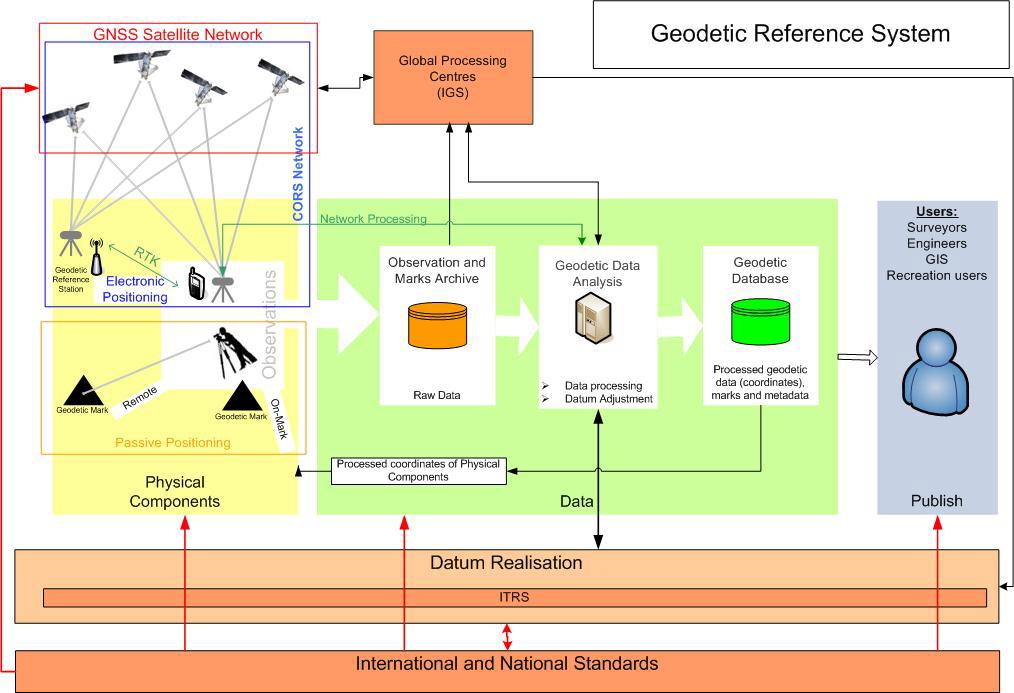
9 What was the NT s Geospatial Reference System (GRS)?
10 Geocentric Datum of Australia -GDA is a static / plate fixed datum. Based on International Terrestrial Reference Frame (ITRF) 1992 at epoch 1 January 1994, Reference Ellipsoid - GRS80 Grid coordinates: UTM, Map Grid of Australia 1994 (MGA94) easting and northing metres Geographical coordinate set: Geocentric Datum of Australia 1994 (GDA94) - latitude and longitude degrees AusGeoid 98 (±0.5m); AusGeoid 09 (±0.1m) for GNSS measurements Working height surface AHD - Australian Height Datum
11 NT Geodetic datasets prior to modernisation Originally compromised of a passive network terrestrial data, episodic / campaign style GPS measurements constrained by AFN (2), ANN (15) and TGN (120) GPS campaigns adjustment, observations, results information stored / accessed via a series of static file and paper based system estimate of national datum PU > 30mm horizontally, >50 mm vertically
12 What is NT s GRS used for?
13 Is the reference layer that underpins most geospatial land, water, space datasets and the spine of GIS or LIS Allows interoperability and integration of a nation s fundamental or foundation datasets Integral component of geospatial activity in surveying, mapping, ubiquitous positioning applications, location based services, and imagery data collection Recognised as essential and enabling infrastructure supporting informed decision making and sustainable economic development Critical to geoscience activity as it measures and monitors the dynamics of the earth. Capability to support global observing systems for accurate scientific research modelling - inter / intra tectonic plate deformation, sea level monitoring, climate change, atmospherics
14 What is a modernised GRS?
15 Characteristics of a Modernised GRS Propagation of co-ordinates and uncertainties via a rigorous, nationwide adjustment of geodetic information. Accurate traceable connection to ITRF Support positioning with HORIZ uncertainties < 20mm, VERT < 50mm 3D with a national Geoid model Seamlessly aligned with positioning infrastructure and services. Enable time-based correction plate and deformation models. Users contribute measurements to an automated system for exchange of geodetic data. Products and services are delivered through web based systems Datum (real time positioning) realised through digital communications and the Internet Support global trends in geospatial, location intelligence etc
16
17 Why do we need to modernise?
18 The NT GRS in the future will no longer be fit for purpose (for various reasons)
19 Drivers for Modernisation 1. NT GRS (GDA 94) not accurate enough to meet future users need! (that is, for scientific to ubiquitous positioning - therefore improve GDA94 to be mm accurate) 2. NT GRS (datum) definition is not aligned with GNSS (GPS, Galileo, Compass etc); and regional / global reference frames (plate tectonics and local deformation, take advantage of modernised multi GNSS environment) 3. NT GRS (datum) will not be aligned with future positioning or location based service providers ( GNSS / Ubiquitous Real Time centimetre accurate positioning and location based services will be relative to a regional (APREF) or global reference frame (ITRF) and so will big data providers)
20 To improve GDA94 and enhance it s mathematical relationship with ITRF AND To facilitate the pursuit of more accurate positioning for users We are located on a dynamic continent on a continually deforming planet! THUS We need to better understand this movement through measurement, modelling and monitoring
21 How to modernise the NT GRS

22 Organisational Structure ANZLIC membership Develop - polices / arrangements / procurement / finances / data agreements / legal / advocacy / communication plans etc Implement technical aspects, Establish standards / practices / guidelines
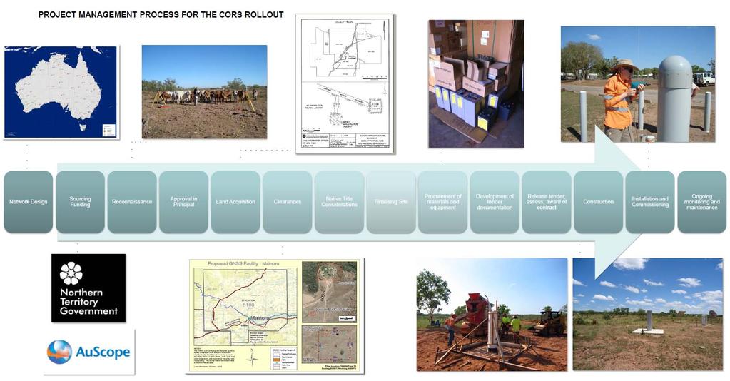
23 The Operational Plan 13 Steps Activity or Task Type Work time 1. Complete the rollout of geodetic quality permanent GNSS CORS (i.e. AuScope stations) across the Territory by 2012/13 Operational 18 months 7. Integrate survey control positional uncertainty information into the Territory s geodetic survey control data base known as NTGESS. Operational 6 months 2. Perform new high accuracy GNSS observations between GNSS CORS and the 110 TGN GPS stations that were occupied from previous GDA 94 campaigns Operational 18 months 8. Adoption of the new ICSM PCG standards and best practices for datum control surveys, and the preparation of supporting Territory standards and best practices for datum control surveys. Legal / Policy 6 months 3. Consider re-processing of critical or salient GDA 94 TGN GPS campaign data / baselines with present day algorithms, models, techniques and ITRF based orbits. Operational 3 months 9. Support the implementation of egeodesy as the geodetic data model and standard for the exchange of geodetic information, results and observations as espoused by Donnelly and Fraser (2010). Institutional / Policy / Operational On going Convert existing geodetic least squares adjustment data files from a Operational 4. "Newgan" application format to a DynaNet format and engine platform. It includes work such as the cleansing, combining, validating and then building the observational datasets; designing and implementing business rules to manage such data. 9 months Consider and evaluate the creation of a vertical DynaNet data set for the Territory s bench mark network. Operational Expand the recognised value standard position through the Legal / Policy / proliferation of Regulation 13 certificates to eligible survey control Operational marks, thus allow surveyors to achieve legal traceability of their GNSS measurements via position and comply with the National Measurement Act (NMA) months Ongoing Readjustment of the entire Territory geodetic network and subsequent Operational 5. survey control networks. 6 months 12. Support and actively participate in ICSM endorsed initiatives that preserve and facilitate the development and maintenance of the Territory s geodetic datum. Institutional Ongoing 6. Propagate the positional uncertainties for geodetic control. Operational 3 months 13. Support and actively participation in national initiatives that promote positioning networks as enabling or critical infrastructure. Institutional Ongoing
24 The Timeframe Year 1 Year 2 Year 3 Months TASK
25 Geospatial / Geodetic Infrastructure

 ground stations and receivers, and Gravity")
26 Supporting global positioning and datum realisation AuScope s key geospatial infrastructure investment includes new and upgraded: Very Long Baseline Interferometry (VLBI) array Satellite Laser Ranging (SLR) facilities Global Navigation Satellite Systems (GNSS) ground stations and receivers, and Gravity measurement (GM) instruments.
")


27 VLBI and Satellite Laser Ranging (SLR) VLBI SLR VLBI Array SLR VLBI: 140days/year VLBI: broadband receiver development SLR: two stations in the top 5 of ILRS network


28 SLR VLBI GNSS Beidou DORIS Gravity Yarragadee Geodetic Observatory, Western Australia
29 National GNSS Infrastructure Before AuScope + AuScope GNSS Stations


30 GNSS Station Permanent geodetic quality GNSS receivers and antennae, on geologically stable marks. Monument Antenna Power Receiver Communication Geodesy Science Evaluation 2016 GNSS Networks

31 National GNSS Network Control-Network_v2.1.pdf


32 The NT GNSS CORS Network
33

34 GeoScience Australia the regional data centre GeoScience Australia is the regional data centre responsible for managing, storing, analysing and archiving data and site logs, coordinates and maps from the co-operative network of Continuously Operating Reference Stations across the Australian region and the South Pacific. GA also provides real-time GNSS data streams (AusCORS) and online processing facilities (AusPOS). The NTG recognise that our role is in supporting the ongoing densification, maintenance and operation of the infrastructure and to build capacity within our jurisdiction to assist in meeting national and regional objectives
35 High Level Workflow GNSS Stations Observatories Incoming Incoming FTP NTRIP Translation Edit and QC GA Processing APREF Processing HR Processing Archive and Distribute GA Internal GA External IGS DC s Geodesy Science Evaluation 2016 GNSS Networks
36 Data Products and Accessibility Product Obs. Rate Availability Latency Archived Format Daily 30 sec 24 hours + 2 hours Permanently RINEX2/3 Hourly 30 sec 1 hour + 5 minutes 7 Days RINEX2 High-rate 1 sec 15 minute + 2 minutes Permanently RINEX2 Real-time 1 hz continuous + 2 secs - RTCM3 Public Data Archive ftp://ftp.ga.gov.au/geodesy-outgoing/gnss/ Geodesy Science Evaluation 2016 GNSS Networks


37 Asia Pacific Reference Frame (APREF) Data from 28 countries 16 national agencies participating Approximately 420 Asia Pacific stations Approximately 600 stations routinely analysed Four independent analysis centres Geoscience Australia Curtin University Department of Sustainability and Environment in Victoria, Australia Institute of Geodesy and Geophysics, Chinese Academy of Sciences
38 Generate new APREF solution Initiate new NGCA processing campaign National adjustment Jurisdictional adjustments


39 NGCA National Geodetic Campaign Archive Ongoing contribution to the archives since March 2015 Currently 744 static GNSS observations of duration > 6hrs (from ) unique stations To be continuously supplemented with additional observations 95% of the TGN marks observed for GDA94 realisation have been re-observed during two concentrated campaigns in August 2015 and July 2016 Client supplied data verified and included
 GNSS GNSS in-fill to link disparate/isolated networks GNSS coordination of Lodged ground marks Collaborative Coordination program,")
40 Jurisdictional Data Archive - JDA Creating a Jurisdictional Data Archive Processing of >100 outstanding external consultant networks Reprocessing existing observations and networks Translation of existing datasets Piecing together larger datasets (ZED and DNA) GNSS GNSS in-fill to link disparate/isolated networks GNSS coordination of Lodged ground marks Collaborative Coordination program, supporting Industry in coordination activities 6 hour GNSS observation on high quality AHD marks to fill in gaps in the NGCA network and supplement AusGeoid
41 Jurisdictional Adjustments - JADJ JADJ includes the following data: APREF solution Jurisdictional data archive (JDA) NGCA baselines Seismic Zone Survey National Adjustment (NADJ) NADJ consists of Adjusted coordinates from the previous adjustment APREF solution Results of JADJ combined mega adjustment comprises of 1.8 million observations and points first continental scale geodetic adjustment of this size GDA2020 version 1.0 finalised by end-october 2016


 Fully rigorous")

")

42 National GNSS CORS Solution National GNSS Campaign Solution APREF AUSPOS 6hr+ GNSS sessions Jurisdictional Adjustments National Adjustment of Australian Terrestrial Reference Frame (ATRF) Fully rigorous geometric adjustment aspire for an all station and observations adjustment (down to the street corner) phased adjustment strategy work flows managed automatically (using e-geodesy technology)


43 Develop time based correction, plate tectonic and deformation models. Crustal Motion Residual Crustal Deformation
, a geoid model is often used.")

44 AusGeoid2020 Height information from GNSS is referenced to the ellipsoid To convert between the ellipsoid and a commonly used surface such as an approximation of sea level (MSL), a geoid model is often used. AUSGeoid2020 has been developed to convert GDA2020 ellipsoidal heights to AHD heights; it will also provide an uncertainty value. Aim to improve AUSGeoid contribution to support reliable AHD heighting using GNSS make observations on benchmarks which have been orthometrically levelled. AUSGeoid2020_Betav0.2 - GeoScience Australia

45 Local data management Positional Uncertainty (Lat) (Long) (Ellip Ht) How do we manage data? Databases for storing/archiving observations, resultant coordinates; metadata and attribute information, including epoch and positional uncertainty Transfer of data within and outside of our Organisation? Apply standards
46 Summary of OUR activities Establishment of infrastructure to support the maintenance of the ITRF Contribution of data to a regional reference frame realisation Enhancement of National geodetic adjustment Realisation of uncertainty with respect to datum Ongoing... Achieved through National collaboration, national approach - technical/financial/administrative commitment Efforts over a 10-year + period Consistent approach, supported by standards and guidelines
47 Actions and Challenges in the future? Implementation and adoption of the new datum, GDA2020 Infrastructure and system maintenance, refinement and upgrade Maintaining relevancy within our Organisation to receive support in terms of funding, committed FTE, resourcing, inclusion in strategic planning Supporting national objectives - National Positioning Infrastructure (NPI). Among others
48 Thankyou. Amy Peterson Rob Sarib Survey Services Land Information Division Department of Infrastructure, Planning and Logistics
Next Generation Australian Datum. Permanent Committee on Geodesy, ICSM
 Next Generation Australian Datum Permanent Committee on Geodesy, ICSM 2 Presentation: Next Generation Australian Datum Trends in the geospatial sector The Geocentric Datum of Australia 1994 (GDA94) Progress
Case Study of Australia
 Case Study of Australia John Dawson, Geoscience Australia 1 Australia s Geodetic eco-system Geocentric Coordinates Observing Infrastructure Height Datum Geoid Models Tools Services Standards 2 Australia
Reference frames and positioning
 The APREF Project: an Improved Geodetic Infrastructure for Asia and the Pacific (4861) John Dawson (Australia), Graeme Blick (New Zealand), Manoj Deo, Guorong Hu and Gary Johnston (Australia) Reference
A Deformation Model to support a Next Generation Australian Geodetic Datum
 A Deformation Model to support a Next Generation Australian Geodetic Datum Richard Stanaway, Surveying and Geospatial Engineering School of Civil and Environmental Engineering multi-gnss + augmentation
Working Group 1. Geodetic Reference Frame. Activity Report. for. The UN-GGIM-AP Plenary Meeting
 Regional Committee of United Nations Global Geospatial Information Management for Asia and the Pacific (UN-GGIM-AP) Established by a United Nations Resolution Working Group 1 Geodetic Reference Frame Activity
Report for 15th PCGIAP Meeting at 18th UNRCC-AP Working Group 1 Regional Geodesy
 Report for 15th PCGIAP Meeting at 18th UNRCC-AP Working Group 1 Regional Geodesy Chairman Shigeru Matsuzaka, Japan - shigeru@gsi.go.jp Vice Chairman Prof. Pengfei Cheng, China - chengpf@casm.ac.cn John
Frames for the Future New Datum Definitions for Modernization of the U.S. National Spatial Reference System
 Figure 10. Horizontal position differences (in meters) between NAD 83 and ITRF 08 at time 2022.00 (January 1, 2022). Positional differences are shown for the North American and Pacific tectonic plates.
Country Report on SDI Activities in Singapore *
 UNITED NATIONS E/CONF.100/CRP.9 ECONOMIC AND SOCIAL COUNCIL Eighteenth United Nations Regional Cartographic Conference for Asia and the Pacific Bangkok, 26-29 October 2009 Item 7(a) of the provisional
From Global to National Geodetic Reference Frames: how are they connected and why are they needed?
 From Global to National Geodetic Reference Frames: how are they connected and why are they needed? Zuheir ALTAMIMI Institut National de l Information Géographique et Forestière, France Vice-President,
Background Document: Report of the Regional Committee of United Nations Global Geospatial Information Management for Asia and the Pacific
 Background Document: Report of the Regional Committee of United Nations Global Geospatial Information Management for Asia and the Pacific 1. Summary 1. This report highlights the activities carried out
Vertical Reference Frame Pacific
 Vertical Reference Frame Pacific Andrick Lal SPC Geoscience Division GIS&RS User Conference 29 th November 2016 USP, Fiji. What does it mean? All buildings and features have a height. But what is it relative
ICSM delivering benefits through collaboration
 ICSM delivering benefits through collaboration Russell Priebbenow Chair and Queensland Member Australia and New Zealand s Intergovernmental Committee on Surveying and Mapping Overview Who is ICSM & why
CORS Network and Datum Harmonisation in the Asia-Pacific Region. Richard Stanaway and Craig Roberts
 CORS Network and Datum Harmonisation in the Asia-Pacific Region Richard Stanaway and Craig Roberts School of Surveying and Spatial Information Systems University of New South Wales CORS Networks in the
BUILDING AN ACCURATE GIS
 BUILDING AN ACCURATE GIS 2006 GIS in the Rockies Denver, Colorado September 13, 2006 William E. Linzey United States Department of Commerce National Oceanic and Atmospheric Administration National Geodetic
FIG Asia Pacific Capacity Development Network
 FIG Asia Pacific Capacity Development Network Report to the 41th General Assembly FIG Congress 2018, Istanbul - Turkey Rob Sarib Chair FIG Asia Pacific Capacity Development Network (AP CDN) Story of the
Positioning in the Pacific Islands
 Positioning in the Pacific Islands Andrick Lal United Nations/Nepal Workshop on the Applications of Global Navigation Satellite Systems Kathmandu - Nepal 15 th December 2016 Presentation Outline Introduction
Modernization of National Geodetic Datum in China *
 UNITED NATIONS E/CONF.102/IP.16 ECONOMIC AND SOCIAL COUNCIL Nineteenth United Nations Regional Cartographic Conference for Asia and the Pacific Bangkok, 29 October 1 November 2012 Item 6(b) of the provisional
A Strategic Plan for Geodesy in Sweden. Mikael Lilje Lars E. Engberg Geodesy Department Lantmäteriet Sweden
 A Strategic Plan for Geodesy in Sweden Mikael Lilje Lars E. Engberg Geodesy Department Lantmäteriet Sweden Our vision is to be able to meet Swedish society s needs for a homogeneous, sustainable geodetic
The Geodetic Infrastructure in Australia and New Zealand: Differences and Similarities
 The Geodetic Infrastructure in Australia and New Zealand: Differences and Similarities Graeme BLICK, New Zealand and Robert SARIB, Australia Key words: Geodetic, Infrastructure, Geospatial, Reference Frames
Reference Frame in Practice Workshop 1A
 Reference Frame in Practice Workshop 1A Status of Geodetic Infrastructure in the Pacific Region Case Studies Rob Sarib - FIG Commission 5 Vice Chair of Administration Welcome! Bula! Who are the International
Faatasi Malologa (PGSC Chair) Director Department of Lands & Survey, Tuvalu
 Director Department of Lands & Survey, Tuvalu") Seventh Session of the United Nations Committee of Experts on Global Geospatial Information Management (UN-GGIM) - 31 July -4 August 2017 Faatasi Malologa (PGSC Chair) Director Department of Lands & Survey,
Seventh Session of the United Nations Committee of Experts on Global Geospatial Information Management (UN-GGIM) - 31 July -4 August 2017 Faatasi Malologa (PGSC Chair) Director Department of Lands & Survey,
Country Report On Sdi Activities In Singapore ( )
") UNITED NATIONS E/CONF.102/IP.4 ECONOMIC AND SOCIAL COUNCIL Nineteenth United Nations Regional Cartographic Conference for Asia and the Pacific Bangkok, 29 October 1 November 2012 Item 6(b) of the provisional
UNITED NATIONS E/CONF.102/IP.4 ECONOMIC AND SOCIAL COUNCIL Nineteenth United Nations Regional Cartographic Conference for Asia and the Pacific Bangkok, 29 October 1 November 2012 Item 6(b) of the provisional
What are the social, technical, environmental and economic benefits and opportunities of accessing and sharing geodetic data?
 What are the social, technical, environmental and economic benefits and opportunities of accessing and sharing geodetic data? Graeme Blick Group Manager Positioning and Resilience Land Information New
SIRGAS: Basis for Geosciences, Geodata, and Navigation in Latin America
 SIRGAS: Basis for Geosciences, Geodata, and Navigation in Latin America Claudio Brunini President of SIRGAS Universidad Nacional de La Plata, Argentina María Virginia Mackern President of SIRGAS/WG-I:
The many paths to a common ground: A comparison of transformations between GDA94 and ITRF
 International Global Navigation Satellite Systems Society IGNSS Symposium 2011 University of New South Wales, Sydney, NSW, Australia 15 17 November 2011 The many paths to a common ground: A comparison
Streamlining the Exchange of Geodetic Data in Australia and New Zealand
 Mrs. Jemma PICCO, Mr. Matthew HIGGINS, Mr. Robert SARIB and Mr. Gary Johnston, Australia and Mr. Graeme BLICK, New Zealand Key words: egeodesy, Geodetic Data, Positioning, Standards, ICSM SUMMARY The core
The Impact of the 2010 Darfield (Canterbury) Earthquake on the Geodetic Infrastructure in New Zealand 1
 Earthquake on the Geodetic Infrastructure in New Zealand 1") The Impact of the 2010 Darfield (Canterbury) Earthquake on the Geodetic Infrastructure in New Zealand 1 Graeme BLICK, John BEAVAN, Chris CROOK, Nic DONNELLY Keywords: Darfield Earthquake, control, survey,
The Impact of the 2010 Darfield (Canterbury) Earthquake on the Geodetic Infrastructure in New Zealand 1 Graeme BLICK, John BEAVAN, Chris CROOK, Nic DONNELLY Keywords: Darfield Earthquake, control, survey,
Post-Processed Precise Point Positioning: A Viable Alternative?
 Post-Processed Precise Point Positioning: A Viable Alternative? Thomas Grinter Survey Infrastructure and Geodesy, Land and Property Information NSW Department of Finance & Services Thomas.Grinter@lpi.nsw.gov.au
GGOS. Global Geodetic Observing System. Carey Noll NASA GSFC (on behalf of GGOS) WDS Forum September 11, 2016
 WDS Forum September 11, 2016") https://ntrs.nasa.gov/search.jsp?r=20160011397 2018-12-07T18:04:29+00:00Z GGOS Global Geodetic Observing System Carey Noll NASA GSFC (on behalf of GGOS) WDS Forum September 11, 2016 Global Geodetic Observing
https://ntrs.nasa.gov/search.jsp?r=20160011397 2018-12-07T18:04:29+00:00Z GGOS Global Geodetic Observing System Carey Noll NASA GSFC (on behalf of GGOS) WDS Forum September 11, 2016 Global Geodetic Observing
Geodetic & Geospatial Infrastructure/Systems
 Geodetic & Geospatial Infrastructure/Systems 1. Geodetic System: Borneo Triangulation 1968 (BT68) 2. Geospatial System: Land and Survey Information System (LASIS) LAND AND SURVEY DEPARTMENT SARAWAK An
This presentation covers the following areas
 Geodetic Datums and Coordinate Systems for Surveying and Mapping in Hong Kong FIG Working Week 2012 Rome, Italy 6-10 May Simon KWOK Hong Kong, China 1 This presentation covers the following areas Explains
4 Survey Datums. 4.1 Horizontal Datum Policy SURVEY DATUMS SEPTEMBER 2006
 4 Survey Datums Today s multi-organizational Project Development efforts require the use of common, accurate horizontal and vertical survey datums and consistent, precise control-survey procedures to ensure
REGIONAL REFERENCE FRAMES: THE IAG PERSPECTIVE
 REGIONAL REFERENCE FRAMES: THE IAG PERSPECTIVE João Agria Torres SPUIAGG IAG Sub-commission 1.3: Regional Reference Frames jatorres@iol.pt 1. About the IAG CONTENT 2. Objectives and organization of SC
INSPIRATION RESULTS AND BENEFITS ALBANIA
 INSPIRATION RESULTS AND BENEFITS ALBANIA By Eng. Besnik Çomo Paper prepared for E&I Workshop: Support to INSPIRE Implementation in enlargement and EWP Countries JRC ISPRA Central Office of Immovable Property
NATRF 2022 AND LDP OCTOBER 11, 2017
 NATRF 2022 AND LDP OCTOBER 11, 2017 MODERNIZATION OF THE NSRS Why? Leaving passive control marks behind and relying solely on the CORS network for 3D positions: Older methodology relies on terrestrial
Report of Uruguay The National Spatial Data Infrastructure
 Report of Uruguay The National Spatial Data Infrastructure Prepared for High-Level Forum on Global Geospatial Information Management (GGIM) and Inaugural Session of the UN Committee of Experts on GGIM
Pacific Geospatial and Surveying Council (PGSC) Geospatial and GNSS CORS Infrastructure Forum. Kuala Lumpur October
 Geospatial and GNSS CORS Infrastructure Forum. Kuala Lumpur October") Pacific Geospatial and Surveying Council (PGSC) Geospatial and GNSS CORS Infrastructure Forum. Kuala Lumpur 16-17 October Beginning and Progress Members PGSC Charter PGSC Strategy 2017-2027 Meetings Geodetic
Pacific Geospatial and Surveying Council (PGSC) Geospatial and GNSS CORS Infrastructure Forum. Kuala Lumpur 16-17 October Beginning and Progress Members PGSC Charter PGSC Strategy 2017-2027 Meetings Geodetic
CHILEAN PART OF SIRGAS REFERENCE FRAME, REALIZATION, ADOPTION, MAINTENANCE AND ACTUAL STATUS. Geodesy for Planet Earth IAG 2009, Buenos Aires
 CHILEAN PART OF SIRGAS REFERENCE FRAME, REALIZATION, ADOPTION, MAINTENANCE AND ACTUAL STATUS Geodesy for Planet Earth IAG 2009, Buenos Aires Ing. Héctor Parra hparra@igm.cl, IGM Chile Dr. Juan Báez jbaez@udec.cl,
Economic and Social Council
 United Nations Economic and Social Council Distr.: General 18 July 2016 Original: English Committee of Experts on Global Geospatial Information Management Sixth session New York, 3-5 August 2016 Item 2
Collaboration, Automation & Foundation Data: three steps towards spatially enabled government **
 ADVANCE UNEDITED VERSION UNITED NATIONS E/CONF.103/25 ECONOMIC AND SOCIAL COUNCIL Tenth United Nations Regional Cartographic Conference for the Americas New York, 19-23, August 2013 Item 6 (a) of the provisional
Height Modernization 2013 A New Canadian Vertical Datum
 Height Modernization 2013 A New Canadian Vertical Datum What is Height Modernization? The Height Reference System Modernization is a project at the Geodetic Survey Division (GSD) of Natural Resources Canada
Spatially Enabled Society
 International Seminar on Land Administration Trends and Issues in Asia and the Pacific Region Spatially Enabled Society Abbas Rajabifard Vice Chair PCGIAP-WG3 Vice-President (President Elect), GSDI Association
The International Federation of Surveyors (FIG)
") The International Federation of Surveyors (FIG) What is the FIG Asia Pacific Capacity Development Network? What are the capacity development challenges with respect to Data, Maps, Geospatial and Geodetic
The International Federation of Surveyors (FIG) What is the FIG Asia Pacific Capacity Development Network? What are the capacity development challenges with respect to Data, Maps, Geospatial and Geodetic
How GNSS CORS in Japan works for geodetic control and disaster mitigations
 ICG Working Group D Reference Frames, Timing and Applications How GNSS CORS in Japan works for geodetic control and disaster mitigations ICG11, Nov. 7-11, 2016, Sochi, Russia Hiromichi TSUJI Geodetic Observation
Do we need to update PNG94 to PNG2020?
 Do we need to update PNG94 to PNG2020? Richard Stanaway Quickclose Pty Ltd Robert Rosa PNG University of Technology, Lae Does PNG94 have a use by date? PNG94 is now 23 years old (reference epoch) Users
The National Spatial Reference System of the Future
 The National Spatial Reference System of the Future William Stone Southwest Region (AZ, NM, NV, UT) Geodetic Advisor william.stone@noaa.gov NOAA s National Geodetic Survey geodesy.noaa.gov Salt Lake City
Report of the Regional Committee of UN-GGIM for Asia and the Pacific (UN-GGIM-AP)
") Report of the Regional Committee of UN-GGIM for Asia and the Pacific (UN-GGIM-AP) At the Eighth Session of UN-GGIM UN Headquarters, New York, 1 3 August 2018 About UN-GGIM-AP One of the five regional committees
Report of the Regional Committee of UN-GGIM for Asia and the Pacific (UN-GGIM-AP) At the Eighth Session of UN-GGIM UN Headquarters, New York, 1 3 August 2018 About UN-GGIM-AP One of the five regional committees
Operational Aspects of GNSS CORS What is a GNSS CORS system used for?
 Please insert a picture (Insert, Picture, from file). Size according to grey field (10 cm x 25.4 cm). Scale picture: highlight, pull corner point Cut picture: highlight, choose the cutting icon from the
THE ROLE OF GEOSPATIAL AT THE WORLD BANK
 THE ROLE OF GEOSPATIAL AT THE WORLD BANK INSPIRE Conference Barcelona, Spain September 26, 2016 Kathrine Kelm Senior Land Administration Specialist Global Land and Geospatial Unit The World Bank Group
Data Origin. How to obtain geodata? Ron van Lammeren CGI-GIRS 0910
 Data Origin How to obtain geodata? Ron van Lammeren CGI-GIRS 0910 Spatial Data interest Improvement of policy making. ± 90% of all information used by government has spatial characteristics SPATIAL INFORMATION
What is the FIG Asia Pacific Capacity Development Network?
 What is the FIG Asia Pacific Capacity Development Network? What are the capacity development challenges with respect to Geospatial and Geodetic Infrastructure? The International Federation of Surveyors
Report of PCGIAP to the 18 th United Nations Regional Cartographic Conference for Asia and the Pacific (UNRCC-AP) for the period
 for the period") Permanent Committee on GIS Infrastructure for Asia and the Pacific (PCGIAP) Established in 1995 by a United Nations Resolution Report of PCGIAP to the 18 th United Nations Regional Cartographic Conference
Permanent Committee on GIS Infrastructure for Asia and the Pacific (PCGIAP) Established in 1995 by a United Nations Resolution Report of PCGIAP to the 18 th United Nations Regional Cartographic Conference
Cooperation is the key, FIG can facilitate
 Cooperation is the key, FIG can facilitate Mikael Lilje Vice President 2017-2020 Head, Geodetic infrastructure, Swedish mapping, cadastral and land registration authority Presented at the GIS/RS Conference
Data Origin. Ron van Lammeren CGI-GIRS 0910
 Data Origin Ron van Lammeren CGI-GIRS 0910 How to obtain geodata? Geo data initiative Executive Order 12906, "Coordinating Geographic Data Acquisition and Access: The National Spatial Data Infrastructure,"
ECONOMIC AND SOCIAL COUNCIL
 UNITED NATIONS E/CONF.102/3 ECONOMIC AND SOCIAL COUNCIL Nineteenth United Nations Regional Cartographic Conference for Asia and the Pacific Bangkok, 29 October 1 November 2012 Item 4 of the provisional
Topographic Mapping in Australia: The Future State
 Topographic ping in Australia: The Future State Context Australia s geography and demography Greg Scott Group Leader National ping & Information Group Chair Permanent Committee for Topographic Information
NGS and the Modernization of the National Spatial Reference System (NSRS)
") NGS and the Modernization of the National Spatial Reference System (NSRS) Dr. Dana Caccamise Pacific Southwest Region (CA,NV) Geodetic Advisor dana.caccamise@noaa.gov NOAA s National Geodetic Survey geodesy.noaa.gov
NGS and the Modernization of the National Spatial Reference System (NSRS) Dr. Dana Caccamise Pacific Southwest Region (CA,NV) Geodetic Advisor dana.caccamise@noaa.gov NOAA s National Geodetic Survey geodesy.noaa.gov
An Assessment of the Accuracy of PPP in Remote Areas in Oman
 An Assessment of the Accuracy of PPP in Remote Areas in Oman Rashid AL ALAWI, Sultanate of Oman and Audrey MARTIN, Ireland Keywords: GNSS, PPP, Oman Survey Infrastructure SUMMARY Traditionally, high accuracy
Positioning the Pacific: NOAA s Geospatial Activities. Juliana Blackwell, Director NOAA s National Geodetic Survey March 6, 2012
 Positioning the Pacific: NOAA s Geospatial Activities Juliana Blackwell, Director NOAA s National Geodetic Survey March 6, 2012 A Common Problem of the Early 19 th Century 1807 President Thomas Jefferson
a national geological survey perspective François ROBIDA BRGM (French Geological Survey)
") a national geological survey perspective François ROBIDA BRGM (French Geological Survey) Pre-Conference Seminar on Socio-Economic Value of Geospatial for National and Regional Development 21 August 2017,
a national geological survey perspective François ROBIDA BRGM (French Geological Survey) Pre-Conference Seminar on Socio-Economic Value of Geospatial for National and Regional Development 21 August 2017,
MSGIC Spring Mtg Denton April 23, 2014
 Modernization of the National Spatial Reference System Keeping Pace with Changes in Positioning Technology and User Expectations in a Dynamic World MSGIC Spring Mtg Denton April 23, 2014 Dave Doyle Base
Coordinate systems, measured surveys for BIM, total station for BIM, as-built surveys, setting-out
 Coordinate systems, measured surveys for BIM, total station for BIM, as-built surveys, setting-out What is a BIM What does a BIM do Why use a BIM BIM Software BIM and the Surveyor How do they relate to
Global Geodetic Reference Frame GGRF & Implications for GNSS
 Global Geodetic Reference Frame GGRF & Implications for GNSS On behalf of Gary Johnston Chair GIAC, Ruth Neilan Vice Chair, Global Geodetic Observing System ICG-9 Prague, 10 November 2014 UN GGRF Working
Evaluating the Performance of AUSGeoid2020 in NSW
 Evaluating the Performance of AUSGeoid2020 in NSW Volker Janssen Spatial Services NSW Department of Finance, Services & Innovation Volker.Janssen@finance.nsw.gov.au Tony Watson Spatial Services NSW Department
A National Geocentric Datum and the Administration of Marine Spaces in Malaysia 2
 A National Geocentric Datum and the Administration of Marine Spaces in Malaysia 2 CheeHai TEO 3 and Ahmad FAUZI 4 Abstract Malaysia is a country with two primary land masses, Peninsular Malaysia and East
Geodesy. orientation. shape. gravity field
 Geodesy noun Science of measuring the shape, orientation and gravity field of the Earth and how it changes over time. shape orientation gravity field Positioning has always been important Downstream applications
INTERNATIONAL SLR SERVICE
 ARTIFICIAL SATELLITES, Vol. 46, No. 4 2011 DOI: 10.2478/v10018-012-0004-z INTERNATIONAL SLR SERVICE Stanisław Schillak Space Research Centre, Polish Academy of Sciences Astrogeodynamic Observatory, Borowiec
The Global Statistical Geospatial Framework and the Global Fundamental Geospatial Themes
 The Global Statistical Geospatial Framework and the Global Fundamental Geospatial Themes Sub-regional workshop on integration of administrative data, big data and geospatial information for the compilation
What s the problem? A Modern Odyssey in Search of Relevance. The search for relevance. Some current drivers for new services. Some Major Applications
 A Modern Odyssey in Search of Relevance FIG Working Week, Athens, 24 May 2004 Paul Kelly ANZLIC Executive Director The search for relevance 1. New expectations for spatial services 2. Are we ready to meet
GIS FOR MAZOWSZE REGION - GENERAL OUTLINE
 GIS FOR MAZOWSZE REGION - GENERAL OUTLINE S. Bialousz 1), K Mączewski 2), E. Janczar 2), K. Osinska-Skotak 1) 1) Warsaw University of Technology, Warsaw, Poland 2) Office of the Surveyor of the Mazowieckie
Frequent epoch reference frames instead of instant station positions and constant velocities
 Deutsches Geodätisches Forschungsinstitut Technische Universität München (DGFI-TUM) Frequent epoch reference frames instead of instant station positions and constant velocities Hermann Drewes Deutsches
UN-GGIM: Europe GRF-Europe. Markku Poutanen
 UN-GGIM: Europe GRF-Europe Markku Poutanen Global Geodetic Reference Frame GGRF The UN Committee of Experts on Global Geospatial Information Management (UN-GGIM) decided in July 2013 to formulate and facilitate
The Global Geodetic Observing System (GGOS) of the International Association of Geodesy (IAG)
 of the International Association of Geodesy (IAG)") The Global Geodetic Observing System (GGOS) of the International Association of Geodesy (IAG) Hermann Drewes Representative of the International Union of Geodesy and Geophysics (IUGG) to the Cartographic
The Global Geodetic Observing System (GGOS) of the International Association of Geodesy (IAG) Hermann Drewes Representative of the International Union of Geodesy and Geophysics (IUGG) to the Cartographic
Perspectives and Status Asia Pacific Capacity Development Network
 Perspectives and Status Asia Pacific Capacity Development Network Rob Sarib FIG John Dawson UN GGIM AP WG1 Reference Frames The International Federation of Surveyors (FIG) Established in Paris 1878; Federation
UN Resolution on GGRF ( and its implementation in Europe)
") Presented at the FIG Working Week 2017, UN Resolution on GGRF ( and its implementation in Europe) May 29 - June 2, 2017 in Helsinki, Finland Markku Poutanen, FGI Contents Global Geodetic Reference Frame
Presented at the FIG Working Week 2017, UN Resolution on GGRF ( and its implementation in Europe) May 29 - June 2, 2017 in Helsinki, Finland Markku Poutanen, FGI Contents Global Geodetic Reference Frame
Performance Evaluation of AUSGeoid2020 in NSW
 International Global Navigation Satellite Systems Association IGNSS Symposium 2018 Colombo Theatres, Kensington Campus, UNSW Australia 7 9 February 2018 Performance Evaluation of AUSGeoid2020 in NSW Volker
MODERNIZATION OF THE NSRS
 NATRF 2022 AND LDP SEPTEMBER 12, 2017 MODERNIZATION OF THE NSRS Why? Leaving passive control marks behind and relying solely on the CORS network for 3D positions: Older methodology relies on terrestrial
The Implementation of a Semi-Dynamic Datum in New Zealand Ten Years On
 The Implementation of a Semi-Dynamic Datum in New Zealand Ten Years On Graeme BLICK and Don GRANT Key words: Geodetic, Semi-Dynamic, Datum, Reference Frames SUMMARY In 1998 New Zealand implemented a new
Options for Modernising the Geocentric Datum of Australia
 Options for Modernising the Geocentric Datum of Australia Joel Haasdyk Nic Donnelly Dr. Craig Harrison Survey Infrastructure and Geodesy National Geodetic Office Geoscience Australia NSW Land and Property
GEODETIC NETWORK OF SAUDI ARABIA AND FIDUCIAL STATIONS. GFN OF Saudi Arabia in Based on ITRF2000 Datum
 STUDIES OF TECTONIC MOVEMENTS IN SAUDI ARABIA USING CORS M. Al Rajhi, Ali Al Omar, R. Yanar, F. Kartal, K. Eren, SUBJECT TO TALKS BACKGROUND GEODETIC NETWORK OF SAUDI ARABIA AND FIDUCIAL STATIONS GFN OF
Inventory of United Nations Resolutions on Cartography Coordination, Geographic Information and SDI 1
 Inventory of United Nations Resolutions on Cartography Coordination, Geographic Information and SDI I. Resolutions on Cartography Coordination and Establishment of United Nations Regional Cartographic
Geospatial Data Standards Considerations for the delivery of 2D and 3D spatial data February 2019
 Geospatial Data Standards Considerations for the delivery of 2D and 3D spatial data February 2019 Prepared by: GRCA Geomatics Version Date Summary of Changes Changes Made By: 1.00 March 16, 2018 Version
Publ. Astron. Obs. Belgrade No. 91 (2012), REALIZATION OF ETRF2000 AS A NEW TERRESTRIAL REFERENCE FRAME IN REPUBLIC OF SERBIA
, REALIZATION OF ETRF2000 AS A NEW TERRESTRIAL REFERENCE FRAME IN REPUBLIC OF SERBIA") Publ. Astron. Obs. Belgrade No. 91 (2012), 199-206 Contributed paper REALIZATION OF ETRF2000 AS A NEW TERRESTRIAL REFERENCE FRAME IN REPUBLIC OF SERBIA D. BLAGOJEVIĆ and V. VASILIĆ Faculty of Civil Engineering,
Publ. Astron. Obs. Belgrade No. 91 (2012), 199-206 Contributed paper REALIZATION OF ETRF2000 AS A NEW TERRESTRIAL REFERENCE FRAME IN REPUBLIC OF SERBIA D. BLAGOJEVIĆ and V. VASILIĆ Faculty of Civil Engineering,
The development and implementation of New Zealand Geodetic Datum 2000
 The development and implementation of New Zealand Geodetic Datum 2000 D.B. Grant 1, G.H. Blick 2, M.B. Pearse 3, R.J. Beavan 4, P.J. Morgan 5 1 2 3 4 5 Land Information New Zealand, Private Box 5501, Wellington,
The European Surveying Plot A surveying map of land property: A proposal and it s perspectives
 The European Surveying Plot A surveying map of land property: A proposal and it s perspectives Nikolaos KALAMAKIS, Greece Key words: INSPIRE, Interoperability, National Geographic Organizations, technical
GEOID UNDULATIONS OF SUDAN USING ORTHOMETRIC HEIGHTS COMPARED WITH THE EGM96 ANG EGM2008
 GEOID UNDULATIONS OF SUDAN USING ORTHOMETRIC HEIGHTS COMPARED Dr. Abdelrahim Elgizouli Mohamed Ahmed* WITH THE EGM96 ANG EGM2008 Abstract: Positioning by satellite system determine the normal height above
United Nations Group Of Experts On Geographical Names
 Rudolph MATINDAS, Indonesia or William WATT, Australia Key words: place names, UNGEGN SUMMARY UNGEGN Discussing the strategic aims of UNGEGN and its divisional structure, future direction, and the benefits
The Swedish National Geodata Strategy and the Geodata Project
 The Swedish National Geodata Strategy and the Geodata Project Ewa Rannestig, Head of NSDI Co-ordination Unit, Lantmäteriet, ewa.rannstig@lm.se Ulf Sandgren, Project Manager Geodata Project, Lantmäteriet,
GEOGRAPHIC INFORMATION SYSTEMS Session 8
 GEOGRAPHIC INFORMATION SYSTEMS Session 8 Introduction Geography underpins all activities associated with a census Census geography is essential to plan and manage fieldwork as well as to report results
From PCGIAP to UN GGIM AP: A Regional Perspective on GGIM
 Regional Committee of United Nations Global Geospatial Information Management for Asia and the Pacific (UN-GGIM-AP) Established by a United Nations Resolution From PCGIAP to UN GGIM AP: A Regional Perspective
MEMORANDUM OF UNDERSTANDING
 MEMORANDUM OF UNDERSTANDING between A: EUREF, the Reference Frame Sub-Commission for Europe of the International Association of Geodesy (IAG) and B: EUMETNET, the Network of European Meteorological Services.
Global & National Geodesy, GNSS Surveying & CORS Infrastructure
 Global & National Geodesy, GNSS Surveying & CORS Infrastructure Chris Rizos School of Surveying & Spatial Information Systems University of New South Wales, Sydney, Australia President-elect, International
Semi-Dynamic Datum of Indonesia
 Technical Seminar Reference Frame in Practice, Semi-Dynamic Datum of Indonesia H.Z. Abidin, A.B. Wijanarto, S.T. Wibowo, Susilo, J. Efendi Geospatial Information Agency, Indonesia (BIG) Sponsors: Page
Development of a Virtual Australia Utilising an SDI Enabled Platform
 Development of a Virtual Australia Utilising an SDI Enabled Platform Abbas RAJABIFARD, Andrew BINNS and Ian WILLIAMSON, Australia Key words: SDI, Virtual Australia, enabling platform SUMMARY Spatial Data
Geocentric Datum of Australia - GDA
 Geocentric Datum of Australia - GDA Supporting GDA94 ARC/INFO 7.2.1 ArcView 3.1 An ESRI Australia White Paper September 1999 White Paper Series OVERVIEW... 1 INTRODUCTION... 1 PART 1 ESRI SOLUTION... 2
TOWARDS ROBUST LOCALIZATION OF RTK-GPS TOPOGRAPHIC SURVEYS 23
 TOWARDS ROBUST LOCALIZATION OF RTK-GPS TOPOGRAPHIC SURVEYS Jerry W. Nave, North Carolina A&T University; Tarig A. Ali, American University of Sharjah Abstract Localization is performed to fit the observed
Fundamental Geospatial Datasets in Africa. Andre Nonguierma New York, 03 August 2015
 Fundamental Geospatial Datasets in Africa United Nations Economic Commission for Africa Geoinformation & Spatial Statistics Andre Nonguierma New York, 03 August 2015 Core Data : Lack of consistency Infrastructure
Spatial Enablement Current Activities and Future Directions Abbas Rajabifard, Jude Wallace and Andrew Binns
 Spatial Enablement Current Activities and Future Directions Abbas Rajabifard, Jude Wallace and Andrew Binns This chapter presents and summarises the outcomes of the two major events which have been recently
Incorporation of the Caribbean to the Geocentric Reference System for the Americas SIRGAS
 Incorporation of the Caribbean to the Geocentric Reference System for the Americas SIRGAS W. Martínez M. V. Mackern V. Cioce R. Rodino S.R. De Freitas UN-GGIM: Americas Third Session, October 5 2016, Mexico
Making Sense of Evolving Reference Frames for North America
 Making Sense of Evolving Reference Frames for North America Mike Craymer Geodetic Survey Division, Natural Resources Canada Giovanni Sella U.S. National Geodesy Survey American Geophysical Union 2007 Joint