The National Integrated Land System (NILS) Larry Money June 24, 2005
|
|
|
- Charlene Watkins
- 5 years ago
- Views:
Transcription


1 The National Integrated Land System (NILS) Larry Money June 24, 2005
2 Purpose/Goal Functional Components Design Data Question
3 BLM s Responsibilities (OMB A-16) Public Land Records Public land conveyance data Federal Land Ownership Status Real and mineral property Cadastral Public Land Survey System
4 NILS Facts and Figures BLM manages: 262 million surface acres 700 Million subsurface acres 130 million parcels/ 28,000 PLSS Townships ~ 250 survey and measurement users ~ 900 parcel management users USDA Forest Service manages 8.5 percent of U.S. land
5 Problem to Solve Poor spatial accuracy of base GIS features is a problem compounded by the fact that many other layers are constructed from these base features Multiple programs in the PLSS Maintenance process
6 A simple system to create and manage survey geometry in ArcGIS The system must be extensible, follow survey methods, improve existing datasets, and maintain spatial relationships between the survey networks and associated GIS data

7 1990 s Vision

8 GIS Bridge Survey

9 Geodata.gov Part of the Geospatial One-Stop E-Gov initiative providing access to Federal, State, and Local geospatial data and information.


10 NILS Functional Components Survey Management Measurement Management Parcel Management GeoCommunicator
11 Survey Management This will support the capture of measurement features and metadata directly into a GIS database format. The goal is to minimize the need for data conversion and reconstruction as measured features are incorporated into the land records management system
12 Measurement Management Data Model Tiers PARCEL FABRIC LEGAL DESCRIPTION FABRIC MEASUREMENT NETWORK SURVEY Provides the foundation for the legal description and parcel fabric tiers. Integrated maintenance of cadastral data is made much more efficient when geometry can be shared. Interpretation of (1) the reliability of each point position and (2) where data editing is needed. New data can be added, and data elements that do not contribute to the optimal solution can be removed. 1 Any area can be selected and readjusted, e.g. to update point positions affected by newly-added data.
13 Parcel Management Provides a process for managing land records and cadastral feature data stored in the database model. Provides custom feature classes, tools, and procedures for editing land records in a transactional, history-tracking environment. Support will be provided to allow users to construct and edit legal description fabrics and to create required parcel fabrics from them. Parcel fabrics may include ownership, land use rights, tax assessment, and others. Measurement Network 10 Legal Description Fabric 3 34 Parcel Fabric PARCEL FABRIC NW NE 2 SW SE LEGAL DESCRIPTION FABRIC

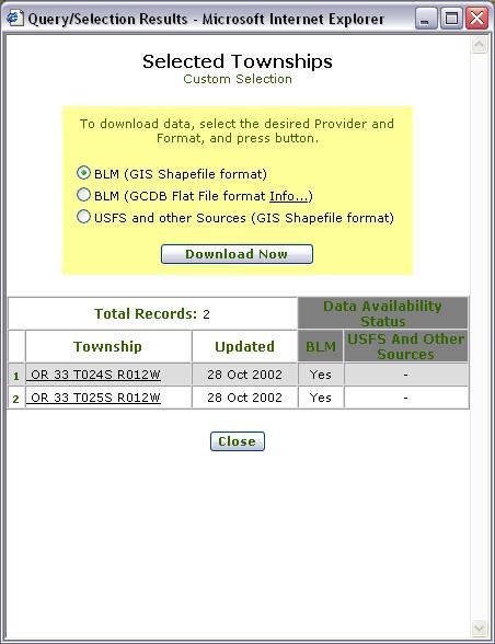
14 GeoCommunicator ww.geocommunicator.gov Internet Site Land Survey Information System Federal Land Stewardship Land & Mineral Use Records Reference Data
15 NILS NILS comprises transactional and publication components: The ArcGIS implementation for creating and maintaining Survey, LD, and Parcel data is the transactional component The ArcIMS implementation for viewing, querying, and downloading data is the publication component
16 Higher Level BLM Business Processes Provide Customer Service Collect And Manage Information Perform Assessment / Analysis Perform Planning Manage Land Use Activity Manage Work Business Process Components Spatial Query and Display NILS Spatial Query and Display SM, MM, PM Data Processes
17 New Survey Data GCDB Parcel Management Business Rules & Custom Applications Input Data Data Prep GCDB files Coverages (LD) LD importer LD Fabric PM Parcel Fabric Flat files (Surveys) SFF Importer Survey Fabric Custom Applications SM/MM Land Records Business Rules Section Subdivision Geodetic Calculations COTS Applications ArcGIS ArcSDE GeoData - base LR2000 Least Squares Analysis Topology Analysis COGO Transaction Database Publication Database ArcIMS LSIS Internet Customer
18 NILS Analysis & Design FGDC Cadastral Standard Legal Description Fabric LegalAreaDescription LADBase ParcelLegalArea LegalAreaRecordBoundary LegalAreaCorner Parcel RecordBoundary Corner (Legal) Parcel Fabric ParcelRecordBoundary RecordBoundaryReference RecordBoundaryCornerPoint ParcelArea Line CornerPoint (Monument) Measurement Network Restriction StraightLine CircularCurve OtherCurve Agent CornerPointMeasuredCoordinate ParcelTransaction TransactionAgent External Parcel Data TransferredRight Address PublicAgency Individual Organization ParcelAddress AgentAddress
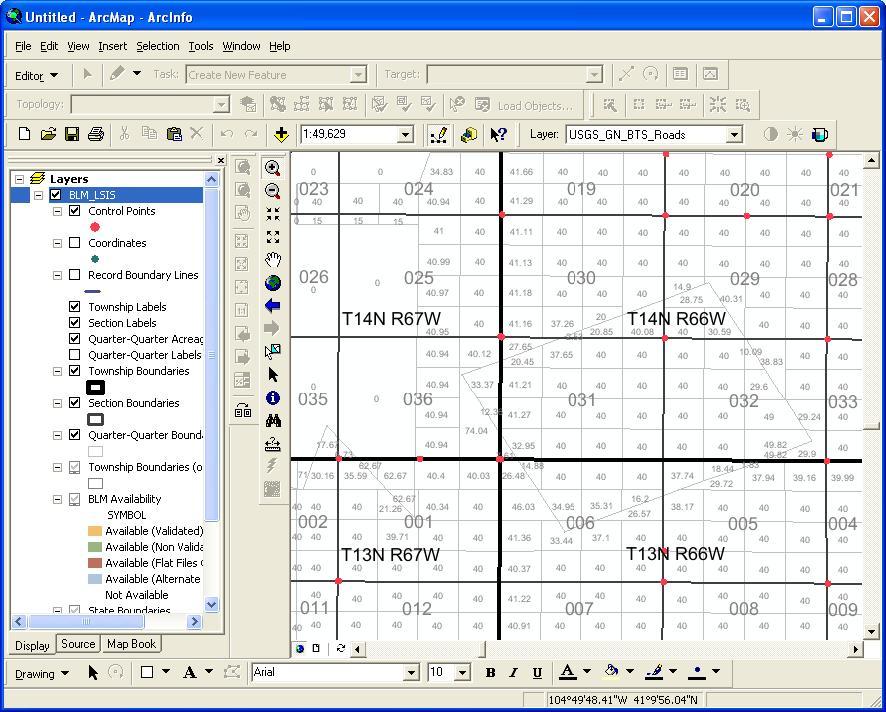
19 NILS Software Architecture Survey Management Measurement Management Parcel Management Survey Analyst Arc Catalog Arc Map Arc ToolBox GeoData Objects Parcels Corner Point Files Spatial Data Engine
20 Primary components: Arc SDE 9.0, Arc GIS 9.0. Arc IMS 4.0 Informix 9.4 Apache Tomcat 4.1 IIS Java SDK/JRE 1.4 FME/Spatial Direct BASS2 Citrix XPe Storage over 1 Terabyte 2 Large database tables over 20 million records each
21
22 Change In Paradigm Data as an: Asset Expense Moving from an EXPENSE to an ASSET
23 Change In Paradigm USFS Centric Application Development Shared Costs Shared Functionality COTS BLM Centric Application Development Shared Standards Greater Efficiency Less Redundancy Greater Share-ability of Data
24 The Use of Standards Federal Geographic Data Committee (FGDC) Cadastral Data Content Standard American Land Titles Association (ALTA) Manual of Instructions for the Survey of the Public Lands of the United States, 1973 Geodatabase designed to reflect existing standards and to work in an object oriented technology environment. Geometry Object Model This diagram summarizes the objects that comprise the geometry system and their relationships. Key Type Inheritance Geometry Abstract Class Geometry CoClass * Association A feature is associated with one of these types of geometry: points, multipoints, polylines, and polygons. Segment Curve BezierCurve CircularArc Line BezierCurve, CircularArc and Line are types of segments that when joined at end points, form a path. Bezier Curve Class Diagram Key CoClass Interface of interest Property Get Property Put Property Get/Put Property Put by Reference Function Event function Circular Arc Segments IConstructLine ILine * Geometry * Envelope Point * Multipoint An envelope is a rectangle that spans a feature. A path is a set of segments which are connected. Line ILine : ICurve Angle: Double Line PutCoords (in from: IPoint, in to: IPoint) QueryCoords (from: IPoint, to: IPoint) IConstructLine : IUnknown ConstructAngleBisector (in from: IPoint, in through: IPoint, in to: IPoint, in Length: Double, in buseacuteangle: Boolean) ConstructExtended (in inline: ILine, extendhow: _esrisegmentextension) Path * * Geometry- Collection Multipoint is a collection of points and is a type of geometry collection. Polycurve Ring Polyline Polygon A ring is a simple non-intersecting area. Ring A point is a discrete x,y location. Paths A polyline is an arbitrary collection of paths. Polyline IPolygon IArea IESRIShape IMAware IMCollection IPointIDAware ITopologicalOperator IRelationalOperator IWin32Shape IZAware IZCollection Polygon IPolygon : IPolycurve ExteriorRingCount: Long A polygon is an arbitrary collection of rings. Polygon (two rings) InteriorRingCount (in exteriorring: IRing) : Long FindExteriorRing (in interiorring: IRing) : IRing QueryExteriorRings (exteriorrings: IRing) QueryInteriorRings (in exteriorring: IRing, interiorrings: IRing)
25 Meta Data Must Be Associated With All Data Sets Data Sets ArcCatalog Coverages CAD Drawing Shapes Tables Images View/Edit as Forms Tins Grids ArcSDE Stored in XML (Structured Document) Any Full FGDC Standard
26 NILS Conceptual Data Model Parcel Fabric Legal Description Fabric Survey Fabric Shared Geometry Survey Links Features Case Parcels Rights Use Authorizations Segregations Land Status Features Corners Boundaries Non-PLSS Classes PLSS Classes Survey Features Survey Points Measures Computations Feature Dataset Survey Dataset

27 GIS Data (Before Survey Analyst) Vector Data Layers Raster Data Layers Land Ownership Transportation Surface Waters Boundaries Geodetic Control Elevation Imagery Land cover Soils Vegetation Slope Others


 School Topo")
28 GIS Data (After Survey Analyst) Vector Data Layers Raster Data Layers Land Ownership Transportation Surface Waters Boundaries Geodetic Control Elevation Imagery Land cover Soils Vegetation Slope Others Survey Data Layers (Projects) School Topo Buildings Total Station Survey 1

29 Data is delivered 3 ways


30 1 Viewable from the web interface

31 2 Downloadable as Shapefiles


32 3 Accessible as a streaming ArcIMS layer


33 Integrate with other data layers through Desktop or Mobile GIS Add data from the internet with the URL:
34 Future Streaming Services BLM National Conservation Areas National Wild and Scenic Rivers National Scenic Trails National Historic Trails BLM Wilderness Areas BLM Wilderness Study Areas BLM Areas of Environmental Concern

35

36 QUESTIONS

37 For additional Information Streaming Service: Map Service: Map Service: BLM_LSIS
ESRI Survey Summit August Clint Brown Director of ESRI Software Products
 ESRI Survey Summit August 2006 Clint Brown Director of ESRI Software Products Cadastral Fabric How does Cadastral fit with Survey? Surveyors process raw field observations Survey measurements define high-order
NR402 GIS Applications in Natural Resources
 NR402 GIS Applications in Natural Resources Lesson 1 Introduction to GIS Eva Strand, University of Idaho Map of the Pacific Northwest from http://www.or.blm.gov/gis/ Welcome to NR402 GIS Applications in
Managing Parcels in ArcGIS 10
 Managing Parcels in ArcGIS 10 ArcGIS Geodatabase Editing Workflows Editing Maps Tim Hensley Esri Solution Engineer Karen Lowrey Esri Geospatial Analyst Basemaps Public Access Value Analysis ArcGIS 10 Parcel
Innovation. The Push and Pull at ESRI. September Kevin Daugherty Cadastral/Land Records Industry Solutions Manager
 Innovation The Push and Pull at ESRI September 2004 Kevin Daugherty Cadastral/Land Records Industry Solutions Manager The Push and The Pull The Push is the information technology that drives research and
Welcome to NR502 GIS Applications in Natural Resources. You can take this course for 1 or 2 credits. There is also an option for 3 credits.
 Welcome to NR502 GIS Applications in Natural Resources. You can take this course for 1 or 2 credits. There is also an option for 3 credits. The 1st credit consists of a series of readings, demonstration,
IMPERIAL COUNTY PLANNING AND DEVELOPMENT
 IMPERIAL COUNTY PLANNING AND DEVELOPMENT GEODATABASE USER MANUAL FOR COUNTY BUSINESS DEVELOPMENT GIS June 2010 Prepared for: Prepared by: County of Imperial Planning and Development 801 Main Street El
ISU GIS CENTER S ARCSDE USER'S GUIDE AND DATA CATALOG
 ISU GIS CENTER S ARCSDE USER'S GUIDE AND DATA CATALOG 2 TABLE OF CONTENTS 1) INTRODUCTION TO ARCSDE............. 3 2) CONNECTING TO ARCSDE.............. 5 3) ARCSDE LAYERS...................... 9 4) LAYER
The File Geodatabase API. Craig Gillgrass Lance Shipman
 The File Geodatabase API Craig Gillgrass Lance Shipman Schedule Cell phones and pagers Please complete the session survey we take your feedback very seriously! Overview File Geodatabase API - Introduction
Geography 38/42:376 GIS II. Topic 1: Spatial Data Representation and an Introduction to Geodatabases. The Nature of Geographic Data
 Geography 38/42:376 GIS II Topic 1: Spatial Data Representation and an Introduction to Geodatabases Chapters 3 & 4: Chang (Chapter 4: DeMers) The Nature of Geographic Data Features or phenomena occur as
Teaching GIS for Land Surveying
 Teaching GIS for Land Surveying Zhanjing (John) Yu Evergreen Valley College, San Jose, California James Crossfield California State University at Fresno, Fresno California 7/13/2006 1 Outline of the Presentation
INTRODUCTION TO ARCGIS Version 10.*
 Week 3 INTRODUCTION TO ARCGIS Version 10.* topics of the week Overview of ArcGIS Using ArcCatalog Overview of ArcGIS Desktop ArcGIS Overview Scalable desktop applications ArcView ArcEditor ArcInfo ArcGIS
Introduction-Overview. Why use a GIS? What can a GIS do? Spatial (coordinate) data model Relational (tabular) data model
 data model Relational (tabular) data model") Introduction-Overview Why use a GIS? What can a GIS do? How does a GIS work? GIS definitions Spatial (coordinate) data model Relational (tabular) data model intro_gis.ppt 1 Why use a GIS? An extension
Introduction-Overview Why use a GIS? What can a GIS do? How does a GIS work? GIS definitions Spatial (coordinate) data model Relational (tabular) data model intro_gis.ppt 1 Why use a GIS? An extension
Experiences and Directions in National Portals"
 FIG Seminar on e-land Administration Innsbruck/Austria 2-4 June 2004 "ESRI's Experiences and Directions in National Portals" Kevin Daugherty Cadastral/Land Records Manager ESRI Topic Points Technology
Introduction to the 176A labs and ArcGIS
 Introduction to the 176A labs and ArcGIS Acknowledgement: Slides by David Maidment, U Texas-Austin and Francisco Olivera (TAMU) Purpose of the labs Hands-on experience with one software pakage Introduction
Display data in a map-like format so that geographic patterns and interrelationships are visible
 Vilmaliz Rodríguez Guzmán M.S. Student, Department of Geology University of Puerto Rico at Mayagüez Remote Sensing and Geographic Information Systems (GIS) Reference: James B. Campbell. Introduction to
Applied Cartography and Introduction to GIS GEOG 2017 EL. Lecture-2 Chapters 3 and 4
 Applied Cartography and Introduction to GIS GEOG 2017 EL Lecture-2 Chapters 3 and 4 Vector Data Modeling To prepare spatial data for computer processing: Use x,y coordinates to represent spatial features
Introduction to the 176A labs and ArcGIS Purpose of the labs
 Introduction to the 176A labs and ArcGIS Purpose of the labs Acknowledgement: Slides by David Maidment, U Texas-Austin and Francisco Olivera (TAMU) Hands-on experience with a leading software package Introduction
Geodatabase Essentials Part One - Intro to the Geodatabase. Jonathan Murphy Colin Zwicker
 Geodatabase Essentials Part One - Intro to the Geodatabase Jonathan Murphy Colin Zwicker Session Path The Geodatabase - What is it? - Why use it? - What types are there? Inside the Geodatabase Advanced
ArcMap - EXPLORING THE DATABASE Part I. SPATIAL DATA FORMATS Part II
 Week 5 ArcMap - EXPLORING THE DATABASE Part I SPATIAL DATA FORMATS Part II topics of the week Exploring the Database More on the Table of Contents Exploration tools Identify, Find, Measure, Map tips, Hyperlink,
ESRI Quality Solution
 ESRI Quality Solution Paul Hardy Business Development Consultant (NMCAs) ESRI Europe phardy@esri.com ESRI Quality Solution Geodatabase Integrity Schema constraints (Attribute Domains etc) Rich data types
GIS Boot Camp for Education June th, 2011 Day 1. Instructor: Sabah Jabbouri Phone: (253) x 4854 Office: TC 136
 x 4854 Office: TC 136") GIS Boot Camp for Education June 27-30 th, 2011 Day 1 Instructor: Sabah Jabbouri Phone: (253) 833-9111 x 4854 Office: TC 136 Email: sjabbouri@greenriver.edu http://www.instruction.greenriver.edu/gis/ Summer
GIS Boot Camp for Education June 27-30 th, 2011 Day 1 Instructor: Sabah Jabbouri Phone: (253) 833-9111 x 4854 Office: TC 136 Email: sjabbouri@greenriver.edu http://www.instruction.greenriver.edu/gis/ Summer
How does ArcGIS Server integrate into an Enterprise Environment? Willy Lynch Mining Industry Specialist ESRI, Denver, Colorado USA
 How does ArcGIS Server integrate into an Enterprise Environment? Willy Lynch Mining Industry Specialist ESRI, Denver, Colorado USA wlynch@esri.com ArcGIS Server Technology Transfer 1 Agenda Who is ESRI?
LRS Task Force June 13, REVISION HISTORY
 North Carolina Department of Transportation Geographic Information Systems (GIS) Unit LINEAR REFERENCING SYSTEM (LRS) PROJECT DEFINITION Version 1.0 REVISION HISTORY Date Document Manager Revision Purpose
Geodatabase 101 Why, What, & How
 Geodatabase 101 Why, What, & How Beau Dealy Dealy Geomatics, LC beau@dealygeo.com Curt Moore InfiniTec, Inc. cmoore@infinitec.net ... first, a brief explanation. Geodata traditionally stored as two components
EEOS 381 -Spatial Databases and GIS Applications
 EEOS 381 -Spatial Databases and GIS Applications Lecture 5 Geodatabases What is a Geodatabase? Geographic Database ESRI-coined term A standard RDBMS that stores and manages geographic data A modern object-relational
Geodatabase An Introduction
 2013 Esri International User Conference July 8 12, 2013 San Diego, California Technical Workshop Geodatabase An Introduction David Crawford and Jonathan Murphy Session Path The Geodatabase What is it?
Imagery and the Location-enabled Platform in State and Local Government
 Imagery and the Location-enabled Platform in State and Local Government Fred Limp, Director, CAST Jim Farley, Vice President, Leica Geosystems Oracle Spatial Users Group Denver, March 10, 2005 TM TM Discussion
CHAPTER 7 PRODUCT USE AND AVAILABILITY
 CHAPTER 7 PRODUCT USE AND AVAILABILITY Julie Prior-Magee Photo from SWReGAP Training Site Image Library Recommended Citation Prior-Magee, J.S. 2007. Product use and availability. Chapter 7 in J.S. Prior-Magee,
Bentley Map Advancing GIS for the World s Infrastructure
 Bentley Map Advancing GIS for the World s Infrastructure Presentation Overview Why would you need Bentley Map? What is Bentley Map? Where is Bentley Map Used? Why would you need Bentley Map? Because your
Why GIS & Why Internet GIS?
 Why GIS & Why Internet GIS? The Internet bandwagon Internet mapping (e.g., MapQuest) Location-based services Real-time navigation (e.g., traffic) Real-time service dispatch Business Intelligence Spatial
Introduction to Geographic Information Systems
 Introduction to Geographic Information Systems Lynn_Carlson@brown.edu 401-863-9917 The Environmental And Remote TecHnologies Lab MacMillan Hall, Room 105 http://www.brown.edu/research/earthlab/ Outline
Geodatabase: Best Practices. Robert LeClair, Senior Instructor
 Geodatabase: Best Practices Robert LeClair, Senior Instructor Agenda Geodatabase Creation Data Ownership Data Model Data Configuration Geodatabase Behaviors Data Validation Extending Performance Geodatabase
GIS Software. Evolution of GIS Software
 GIS Software The geoprocessing engines of GIS Major functions Collect, store, mange, query, analyze and present Key terms Program collections of instructions to manipulate data Package integrated collection
Popular Mechanics, 1954
 Introduction to GIS Popular Mechanics, 1954 1986 $2,599 1 MB of RAM 2017, $750, 128 GB memory, 2 GB of RAM Computing power has increased exponentially over the past 30 years, Allowing the existence of
Outline. Chapter 1. A history of products. What is ArcGIS? What is GIS? Some GIS applications Introducing the ArcGIS products How does GIS work?
 Outline Chapter 1 Introducing ArcGIS What is GIS? Some GIS applications Introducing the ArcGIS products How does GIS work? Basic data formats The ArcCatalog interface 1-1 1-2 A history of products Arc/Info
Mapping Your Land and Introduction to Web Soil Survey. Elizabeth Cook GIS Specialist USDA-NRCS (retired)
") Mapping Your Land and Introduction to Web Soil Survey Elizabeth Cook GIS Specialist USDA-NRCS (retired) Using Geographic Information Systems (GIS), Global Positioning System (GPS), digital aerial photography
Mapping Your Land and Introduction to Web Soil Survey Elizabeth Cook GIS Specialist USDA-NRCS (retired) Using Geographic Information Systems (GIS), Global Positioning System (GPS), digital aerial photography
UNIT 4: USING ArcGIS. Instructor: Emmanuel K. Appiah-Adjei (PhD) Department of Geological Engineering KNUST, Kumasi
 Department of Geological Engineering KNUST, Kumasi") UNIT 4: USING ArcGIS Instructor: Emmanuel K. Appiah-Adjei (PhD) Department of Geological Engineering KNUST, Kumasi Getting to Know ArcGIS ArcGIS is an integrated collection of GIS software products ArcGIS
UNIT 4: USING ArcGIS Instructor: Emmanuel K. Appiah-Adjei (PhD) Department of Geological Engineering KNUST, Kumasi Getting to Know ArcGIS ArcGIS is an integrated collection of GIS software products ArcGIS
Course overview. Grading and Evaluation. Final project. Where and When? Welcome to REM402 Applied Spatial Analysis in Natural Resources.
 Welcome to REM402 Applied Spatial Analysis in Natural Resources Eva Strand, University of Idaho Map of the Pacific Northwest from http://www.or.blm.gov/gis/ Where and When? Lectures Monday & Wednesday
These modules are covered with a brief information and practical in ArcGIS Software and open source software also like QGIS, ILWIS.
 Online GIS Training and training modules covered are: 1. ArcGIS, Analysis, Fundamentals and Implementation 2. ArcGIS Web Data Sharing 3. ArcGIS for Desktop 4. ArcGIS for Server These modules are covered
Steve Pietersen Office Telephone No
 Steve Pietersen Steve.Pieterson@durban.gov.za Office Telephone No. 031 311 8655 Overview Why geography matters The power of GIS EWS GIS water stats EWS GIS sanitation stats How to build a GIS system EWS
Geodatabase An Overview
 Federal GIS Conference February 9 10, 2015 Washington, DC Geodatabase An Overview Ralph Denkenberger - esri Session Path The Geodatabase - What is it? - Why use it? - What types are there? Inside the Geodatabase
Working with the Geodatabase
 Working with the Geodatabase Agenda What is the geodatabase? Benefits of the geodatabase Inside the geodatabase Geodatabase rules Demos Additional resources and training Q & A The Geodatabase is the foundation
Introduction INTRODUCTION TO GIS GIS - GIS GIS 1/12/2015. New York Association of Professional Land Surveyors January 22, 2015
 New York Association of Professional Land Surveyors January 22, 2015 INTRODUCTION TO GIS Introduction GIS - GIS GIS 1 2 What is a GIS Geographic of or relating to geography the study of the physical features
Write a report (6-7 pages, double space) on some examples of Internet Applications. You can choose only ONE of the following application areas:
 on some examples of Internet Applications. You can choose only ONE of the following application areas:") UPR 6905 Internet GIS Homework 1 Yong Hong Guo September 9, 2008 Write a report (6-7 pages, double space) on some examples of Internet Applications. You can choose only ONE of the following application
UPR 6905 Internet GIS Homework 1 Yong Hong Guo September 9, 2008 Write a report (6-7 pages, double space) on some examples of Internet Applications. You can choose only ONE of the following application
CAD: Introduction to using CAD Data in ArcGIS. Kyle Williams & Jeff Reinhart
 CAD: Introduction to using CAD Data in ArcGIS Kyle Williams & Jeff Reinhart What we will accomplish today Overview of ArcGIS CAD Support Georeferencing CAD data for ArcGIS How Mapping Specification for
Providing Public Access to King County GIS Data. Presented by: Michael Jenkins King County GIS Center Seattle, WA
 Providing Public Access to King County GIS Data Presented by: Michael Jenkins King County GIS Center Seattle, WA King County, Washington Microsoft Boeing Amazon.Com Starbucks Port of Seattle Weyerhauser
Introduction to GIS I
 Introduction to GIS Introduction How to answer geographical questions such as follows: What is the population of a particular city? What are the characteristics of the soils in a particular land parcel?
Lecture 5. GIS Data Capture & Editing. Tomislav Sapic GIS Technologist Faculty of Natural Resources Management Lakehead University
 Lecture 5 GIS Data Capture & Editing Tomislav Sapic GIS Technologist Faculty of Natural Resources Management Lakehead University GIS Data Input Surveying/GPS Data capture Facilitate data capture Final
Geodatabase An Introduction
 Federal GIS Conference 2014 February 10 11, 2014 Washington DC Geodatabase An Introduction Ralph Denkenberger esri Session Path The Geodatabase - What is it? - Why use it? - What types are there? Inside
SRJC Applied Technology 54A Introduction to GIS
 SRJC Applied Technology 54A Introduction to GIS Overview Lecture of Geographic Information Systems Fall 2004 Santa Rosa Junior College Presented By: Tim Pudoff, GIS Coordinator, County of Sonoma, Information
ArcGIS. for Server. Understanding our World
 ArcGIS for Server Understanding our World ArcGIS for Server Create, Distribute, and Manage GIS Services You can use ArcGIS for Server to create services from your mapping and geographic information system
Geospatial Products V8i (SELECTseries 1)
") Geospatial Products V8i (SELECTseries 1) Keith Raymond Product Manager Geospatial Desktop Products Presentation Overview What are the various products? Why would you need them? Demonstrations 2 WWW.BENTLEY.COM
Geospatial Products V8i (SELECTseries 1) Keith Raymond Product Manager Geospatial Desktop Products Presentation Overview What are the various products? Why would you need them? Demonstrations 2 WWW.BENTLEY.COM
An Enterprise Geodatabase: Montgomery County, Maryland ESRI 2004 User Conference Paper #1674
 An Enterprise Geodatabase: Montgomery County, Maryland ESRI 2004 User Conference Paper #1674 1.0 ABSTRACT Montgomery County, Maryland has a long history of supporting GIS applications with a SDE/ArcSDE
Discovery and Access of Geospatial Resources using the Geoportal Extension. Marten Hogeweg Geoportal Extension Product Manager
 Discovery and Access of Geospatial Resources using the Geoportal Extension Marten Hogeweg Geoportal Extension Product Manager DISCOVERY AND ACCESS USING THE GEOPORTAL EXTENSION Geospatial Data Is Very
Lecture 12. Data Standards and Quality & New Developments in GIS
 Lecture 12 Data Standards and Quality & New Developments in GIS Lecture 12: Outline I. Data Standards and Quality 1. Types of Spatial Data Standards 2. Data Accuracy 3. III. Documenting Spatial Data Accuracy
Lab 5 - Introduction to the Geodatabase
 Lab 5 - Introduction to the Geodatabase 1. Design Process GIS is becoming an increasingly accessible and important tool for land managers. In this exercise you will begin creating a Personal Geodatabase
Esri UC2013. Technical Workshop.
 Esri International User Conference San Diego, California Technical Workshops July 9, 2013 CAD: Introduction to using CAD Data in ArcGIS Jeff Reinhart & Phil Sanchez Agenda Overview of ArcGIS CAD Support
Esri Training by Microcenter Prepare to Innovate. Microcenter Course Catalog
 Esri Training by Microcenter Prepare to Innovate 2015 Instructor-Led Courses Microcenter Course Catalog ArcGIS Foundational Courses Designed to meet the learning needs of professionals whose GIS experience
Acknowledgments xiii Preface xv. GIS Tutorial 1 Introducing GIS and health applications 1. What is GIS? 2
 Acknowledgments xiii Preface xv GIS Tutorial 1 Introducing GIS and health applications 1 What is GIS? 2 Spatial data 2 Digital map infrastructure 4 Unique capabilities of GIS 5 Installing ArcView and the
Utah UIC Geospatial Integration EIEN Project
 Utah UIC Geospatial Integration EIEN Project ESRI UC, June 2007 Bert Granberg Utah Automated Geographic Reference Center Utah Automated Geographic Reference Center (AGRC) AGRC Responsibilities Facilitate
Introduction. Project Summary In 2014 multiple local Otsego county agencies, Otsego County Soil and Water
 Introduction Project Summary In 2014 multiple local Otsego county agencies, Otsego County Soil and Water Conservation District (SWCD), the Otsego County Planning Department (OPD), and the Otsego County
ISO Series Standards in a Model Driven Architecture for Landmanagement. Jürgen Ebbinghaus, AED-SICAD
 ISO 19100 Series Standards in a Model Driven Architecture for Landmanagement Jürgen Ebbinghaus, AED-SICAD 29.10.2003 The Company 100% SIEMENS PTD SIEMENS Business Services Shareholder & Strategic Business
Session Objectives. Learn how to: Bring georeferenced aerial imagery into Civil 3D. Connect to and import GIS data using various tools and techniques.
 GIS into Civil 3D Data 70th Annual Wisconsin Society of Land Surveyors' Institute January 24, 2019 1 Learn how to: Session Objectives Bring georeferenced aerial imagery into Civil 3D. Connect to and import
The Next Generation GIS/LIS A Surveys Information System Integrated within a GIS
 The Next Generation GIS/LIS A Surveys Information System Integrated within a GIS Michael F. WEIR, USA Key words: Linking, Snapping, GIS, Measurements, Measurement Data, GIS Features, Spatial Quality. SUMMARY
Existing Open Source Tools and Possibilities for Cadastre Systems
 Existing Open Source Tools and Possibilities for Cadastre Systems Gertrude Pieper Espada FIG Congress Sydney, 11-16 April 2010 What is FLOSS? What is open source? What open source software tools are available?
Canadian Board of Examiners for Professional Surveyors Core Syllabus Item C 5: GEOSPATIAL INFORMATION SYSTEMS
 Study Guide: Canadian Board of Examiners for Professional Surveyors Core Syllabus Item C 5: GEOSPATIAL INFORMATION SYSTEMS This guide presents some study questions with specific referral to the essential
StreamStats: Delivering Streamflow Information to the Public. By Kernell Ries
 StreamStats: Delivering Streamflow Information to the Public By Kernell Ries U.S. Department of the Interior U.S. Geological Survey MD-DE-DC District 410-238-4317 kries@usgs.gov StreamStats Web Application
Bridging the Gap between Engineering and GIS
 Bridging the Gap between Engineering and GIS Presented by: Karen Stewart, B.Tech, GISP Manager of Geomatics Township of Langley February 13, 2006 Agenda Introduction History Goals Implementation Benefits
Geodatabase Programming with Python
 DevSummit DC February 11, 2015 Washington, DC Geodatabase Programming with Python Craig Gillgrass Assumptions Basic knowledge of python Basic knowledge enterprise geodatabases and workflows Please turn
Geodatabase Management Pathway
 Geodatabase Management Pathway Table of Contents ArcGIS Desktop II: Tools and Functionality 3 ArcGIS Desktop III: GIS Workflows and Analysis 6 Building Geodatabases 8 Data Management in the Multiuser Geodatabase
Introduction to Geographic Information Systems (GIS): Environmental Science Focus
: Environmental Science Focus") Introduction to Geographic Information Systems (GIS): Environmental Science Focus September 9, 2013 We will begin at 9:10 AM. Login info: Username:!cnrguest Password: gocal_bears Instructor: Domain: CAMPUS
Introduction to Geographic Information Systems (GIS): Environmental Science Focus September 9, 2013 We will begin at 9:10 AM. Login info: Username:!cnrguest Password: gocal_bears Instructor: Domain: CAMPUS
Using CAD data in ArcGIS
 Using CAD data in ArcGIS Phil Sanchez and Jeff Reinhart Esri UC 2014 Technical Workshop Agenda Overview of ArcGIS CAD Support Using CAD Datasets in ArcMap Georeferencing CAD data for ArcGIS Loading CAD
Construction Project Data Management
 Construction Project Data Management Establishing Foundations for an Asset Database Scot Twining Project Activities Supported by GIS Cadastral Mapping Proposed Pipeline Route Selection Right Of Way Acquisition
Introduction to ArcGIS Server Development
 Introduction to ArcGIS Server Development Kevin Deege,, Rob Burke, Kelly Hutchins, and Sathya Prasad ESRI Developer Summit 2008 1 Schedule Introduction to ArcGIS Server Rob and Kevin Questions Break 2:15
What is GIS and How Can It Help Me?
 esri European User Conference Madrid 2011 What is GIS and How Can It Help Me? Jaime Nieves Ignacio Vázquez esri spain «Knowing where things are, and why, is essential to rational decision making.» Jack
Coordinate systems, measured surveys for BIM, total station for BIM, as-built surveys, setting-out
 Coordinate systems, measured surveys for BIM, total station for BIM, as-built surveys, setting-out What is a BIM What does a BIM do Why use a BIM BIM Software BIM and the Surveyor How do they relate to
Systems Interoperability at the Port of Long Beach
 Systems Interoperability at the Port of Long Beach Tuesday, June 11, 2013 2:45 pm 4:00 pm, Garden Salon One, 2nd Fl. Presented by: Brien Green, Account Manager, Bentley Systems Daniel Lee, Business Analyst,
Systems Interoperability at the Port of Long Beach
 Systems Interoperability at the Port of Long Beach Tuesday, June 11, 2013 2:45 pm 4:00 pm, Garden Salon One, 2nd Fl. Presented by: Brien Green, Account Manager, Bentley Systems Daniel Lee, Business Analyst,
All About Spatial Data. Find it, Manage it, Use it
 All About Spatial Data Find it, Manage it, Use it Workshop Outline Define spatial data Spatial data formats Data Sources Metadata Evaluating Spatial Data Data Management Activities: define spatial data,
10/13/2011. Introduction. Introduction to GPS and GIS Workshop. Schedule. What We Will Cover
 Introduction Introduction to GPS and GIS Workshop Institute for Social and Environmental Research Nepal October 13 October 15, 2011 Alex Zvoleff azvoleff@mail.sdsu.edu http://rohan.sdsu.edu/~zvoleff Instructor:
GENERALIZATION IN THE NEW GENERATION OF GIS. Dan Lee ESRI, Inc. 380 New York Street Redlands, CA USA Fax:
 GENERALIZATION IN THE NEW GENERATION OF GIS Dan Lee ESRI, Inc. 380 New York Street Redlands, CA 92373 USA dlee@esri.com Fax: 909-793-5953 Abstract In the research and development of automated map generalization,
Geospatial Data Model for Archaeology Site Data
 Authors: David T. Hansen, Barbara D. Simpson, Anastasia Leigh, Patrick Welch, and Lorri Peltz-Lewis Geospatial Data Model for Archaeology Site Data Presented by David T. Hansen and Barbara D. Simpson at
Inside the geodatabase
 Inside the geodatabase A map portrays geographic information through a series of thematic overlays streets, buildings, water, terrain, imagery So does a geographic information system (GIS) Each geographic
Chapter 6. Fundamentals of GIS-Based Data Analysis for Decision Support. Table 6.1. Spatial Data Transformations by Geospatial Data Types
 Chapter 6 Fundamentals of GIS-Based Data Analysis for Decision Support FROM: Points Lines Polygons Fields Table 6.1. Spatial Data Transformations by Geospatial Data Types TO: Points Lines Polygons Fields
1. Which agency in your state is PRIMARILY responsible for archiving geospatial data and managing archived geo records? (choose one) nmlkj.
 nmlkj.") Survey Intro Kentucky, North Carolina, and Utah are partnering with the Library of Congress as part of the National Digital Information Infrastructure and Preservation Program (NDIIPP) to examine the current
Survey Intro Kentucky, North Carolina, and Utah are partnering with the Library of Congress as part of the National Digital Information Infrastructure and Preservation Program (NDIIPP) to examine the current
Exploring the boundaries of your built and natural world. Geomatics
 Exploring the boundaries of your built and natural world Geomatics Before the Luxor brought magic to the Las Vegas strip and before the South LRT extension in Edmonton gave residents a new route to travel,
Introduction to ArcGIS Server - Creating and Using GIS Services. Mark Ho Instructor Washington, DC
 Introduction to ArcGIS Server - Creating and Using GIS Services Mark Ho Instructor Washington, DC Technical Workshop Road Map Product overview Building server applications GIS services Developer Help resources
GIS-T 2010 Building a Successful Geospatial Data Sharing Framework: A Ohio DOT Success Story
 GIS-T 2010 Building a Successful Geospatial Data Sharing Framework: A Ohio DOT Success Story ODOT District 2 GIS John Puente District 1 GIS Coordinator\ Planning Administrator 2 Interoperability 3 District
ArcGIS Runtime: Migrating Your Apps from ArcGIS Engine. Eric Bader Lucas Danzinger Mike Branscomb
 ArcGIS Runtime: Migrating Your Apps from ArcGIS Engine Eric Bader Lucas Danzinger Mike Branscomb Migrating to ArcGIS Runtime ArcGIS Engine ArcGIS Runtime AppStudio for ArcGIS Apps: Collector, Workforce,
Geog 469 GIS Workshop. Managing Enterprise GIS Geodatabases
 Geog 469 GIS Workshop Managing Enterprise GIS Geodatabases Outline 1. Why is a geodatabase important for GIS? 2. What is the architecture of a geodatabase? 3. How can we compare and contrast three types
Administering your Enterprise Geodatabase using Python. Jill Penney
 Administering your Enterprise Geodatabase using Python Jill Penney Assumptions Basic knowledge of python Basic knowledge enterprise geodatabases and workflows You want code Please turn off or silence cell
Trail Flow: Analysis of Drainage Patterns Affecting a Mountain Bike Trail
 Andy Belcher BAE 590 Professor Huffman 12.9.11 Location Trail Flow: Analysis of Drainage Patterns Affecting a Mountain Bike Trail The location of the project area rests in the Cary area of Wake County,
Geodatabase Programming with Python John Yaist
 Geodatabase Programming with Python John Yaist DevSummit DC February 26, 2016 Washington, DC Target Audience: Assumptions Basic knowledge of Python Basic knowledge of Enterprise Geodatabase and workflows
The Emerging Role of Enterprise GIS in State Forest Agencies
 The Emerging Role of Enterprise GIS in State Forest Agencies Geographic Information System (GIS) A geographic information system (GIS) is a computer software system designed to capture, store, manipulate,
Key Points Sharing fosters participation and collaboration Metadata has a big role in sharing Sharing is not always easy
 Sharing Resources Geoff Mortson esri, Inc. SDI Solutions Team Key Points Sharing fosters participation and collaboration Metadata has a big role in sharing Sharing is not always easy Data Sharing is Good
Technical Specifications. Form of the standard
 Used by popular acceptance Voluntary Implementation Mandatory Legally enforced Technical Specifications Conventions Guidelines Form of the standard Restrictive Information System Structures Contents Values
GIS ADMINISTRATOR / WEB DEVELOPER EVANSVILLE-VANDERBURGH COUNTY AREA PLAN COMMISSION
 GIS ADMINISTRATOR / WEB DEVELOPER EVANSVILLE-VANDERBURGH COUNTY AREA PLAN COMMISSION SALARY RANGE INITIATION $43,277 SIX MONTHS $45,367 POSITION GRADE PAT VI The Evansville-Vanderburgh County Area Plan
Learning ArcGIS: Introduction to ArcCatalog 10.1
 Learning ArcGIS: Introduction to ArcCatalog 10.1 Estimated Time: 1 Hour Information systems help us to manage what we know by making it easier to organize, access, manipulate, and apply knowledge to the
ArcGIS Online Tools and Water-Related Web Services You Can Use Every Day of Your Life!
 ArcGIS Online Tools and Water-Related Web Services You Can Use Every Day of Your Life! Brian Rowley, PE, CFM FMA 2014 Annual Conference 1 Gold Rush (49ers) John Sutter Sutter s Mill South fork of American
ESRI* Object Models; Data Capture
 ESRI* Object Models; Data Capture * Environmental Systems Research Institute Feature Class (spatial table) Number Age_Ma 1_sigma Rx_Type Size_kg 123 124 125 142 1.5 B_schist 136 2.0 G_schist Object Class