Module 3 Educator s Guide Overview
|
|
|
- Hugh Page
- 5 years ago
- Views:
Transcription

1 Module 3 Educator s Guide Overview Where on Earth do humans live? Module Overview This module focuses on Earth as our home and investigates the physical and human landscapes in which we live. Students learn that the world s population is unevenly distributed, and they begin to understand the environmental factors that influence this distribution. Investigation 1: What are physical and human-made features? During this investigation students identify physical and human-made features using images from space. They match images of physical features with definitions of those features and identify physical and human features in images of several U.S. cities. Investigation 2: What is there to see from sea to shining sea? This investigation builds on the first investigation in this module. Students locate and identify more physical and human-made features in the United States using images from space and create their own U.S. maps that are illustrated with NASA images. The song America the Beautiful is used to help students recognize that our country has many different regions and that the landscape of our country is very diverse. Investigation 3: How do images help us learn about our planet Earth? Students interpret a nighttime image of the world using the arrangement of lights to identify broad patterns of world population distribution. They use maps showing landforms and climate regions to help explain the patterns. Geography Standards The World in Spatial Terms Standard 1: How to use maps and other geographic representations, tools, and technologies to acquire, process, and report information from a spatial perspective Places and Regions Standard 4: The physical and human characteristics of places Environment and Society Standard 14: How human actions modify the physical environment The Uses of Geography Standard 17: How to apply geography to interpret the past Science Standards Unifying Concepts and Processes Systems, order, and organization Science as Inquiry Abilities necessary to do scientific inquiry Science and Technology Abilities to distinguish between natural objects and objects made by humans Science in Personal and Social Perspectives Characteristics and changes in populations Changes in environments Investigation 4: Where are the cities? Students compare an image showing nighttime lights in the United States with atlas maps in order to identify major cities and relate population distribution patterns to the physical environment. By locating cities and physical features identified in the nighttime image on an outline map, students become more familiar with important locations in the United States. They also use atlas maps and geographic information to identify NASA images of areas around several major cities. 1
2 Module 3 Connections to the Curriculum This module can be integrated into social studies classes when introducing map and globe skills, continents, landforms, physical systems, differences between regions and cities, or global settlement patterns. The investigations strengthen scientific inquiry skills such as observing, predicting, inferring, classifying, and noting patterns. The song America the Beautiful provides a Language Arts connection as students interpret the lyrics and master new vocabulary. Time Investigation 1: Two 45-minute sessions Investigation 2: Two 45-minute sessions Investigation 3: One 45-minute session Investigation 4: Two 45-minute sessions Overview Mathematics Standards Geometry Use visualization, spatial reasoning, and geometric modeling to solve problems Measurement Understand measurable attributes of objects and the units, systems, and processes of measurement Apply appropriate techniques, tools, and formulas to determine measurements Technological Literacy Standards Nature of Technology Standard 1: The characteristics and scope of technology Technology and Society Standard 4: The cultural, social, economic, and political effects of technology The Designed World Standard 20: Construction technologies 2
3 Module 3 Educator s Guide Investigation 1 What are physical and human-made features? Investigation Overview During this investigation students identify physical and human-made features using images from space. They match images of physical features with definitions of those features and identify physical and human features in images of several U.S. cities. Time required: Two 45-minute sessions Materials/Resources Figure 1: An astronaut photographs Earth (overhead transparency) Globe Crayons Scissors Map of the United States Log 1: What are physical features? (one copy per group of four students) Log 2: Satellite images of physical features (one overhead transparency and one per group of four students) Log 3: New Orleans, Louisiana (one overhead transparency and one per group of four students) Log 4: Corpus Christi, Texas (one overhead transparency and one per group of four students) Log 5: Panama City, Florida (one overhead transparency and one per group of four students) File folders (two per group of four students) Old magazines Content Preview To survive, people depend on the physical environment. They adapt to it and modify it to suit their changing needs for things such as food, clothing, shelter, and energy. They build homes, roads, airports, canals, and dams and transform the environment. Human-made features and naturally occurring features such as rivers, lakes, and coastlines can be observed from space using satellites and Space Shuttle photography. Natural features generally have irregular boundaries while human-made features have more regular geometric shapes. Geography Standards Standard 1: The World in Spatial Terms How to use maps and other geographic representations, tools, and technologies to acquire, process, and report information from a spatial perspective Identify and describe the characteristics and purposes of geographic representations, tools, and technologies. Standard 4: Places and Regions The physical and human characteristics of places Use a variety of graphic materials and data sources to describe the physical and human characteristics of a region. Geography Skills Skill Set 2: Acquire Geographic Information Make and record observations about the physical and human characteristics of places. Skill Set 4: Analyze Geographic Information Use texts, photographs, and documents to observe and interpret geographic trends and relationships. Skill Set 5: Answer Geographic Questions Use methods of geographic inquiry to acquire geographic information, draw conclusions, and make generalizations. Classroom Procedures Beginning the Investigation 1. Show students a globe and guide students to identify its shape as a sphere. Ask if anyone can find the continent on which we live. Have a student locate North America on the globe and name it. Ask students to identify and name the six other continents and four oceans. Write the words Physical Features on the board. Tell them that physical 3
4 Module 3 Educator s Guide Investigation 1 features describe the features of the land such as landforms and water bodies. An example of a physical feature is an island. Ask students to identify other physical features that can be seen on the globe. (Lake, mountain range, island, gulf, bay, peninsula, etc.) Developing the Investigation 2. Divide the students into groups of four and give each group a copy of Log 1. Instruct students to cut out the physical feature definition boxes. Give each student in each group two of these boxes and have them draw a picture of these physical features. Then ask each group to assemble its eight pictures and in a class discussion compare the various pictures of each feature. desert: a land area that receives very little precipitation and thus has sparse vegetation island: an area of land surrounded by water mountain: a natural elevation of Earth s surface; more rugged, steeper, and higher than a hill river: a large natural stream of water emptying into an ocean, lake, or larger body of water bay: any inlet of the ocean bordering on land and partly surrounded by land ocean: the mass of salt water that surrounds the continents lake: an inland body of water usually of considerable size peninsula: an area of land which projects out from a larger land mass and is almost surrounded by water 3. Tell the students that one of NASA s main goals is to learn about our Earth so that we will be able to understand and eventually predict both natural and human-induced global changes. Explain that people make changes to the environment to produce human-made features. Write Human- Made Features on the board and ask students to name some human-made features that are in their hometown, e.g., buildings, bridges, airport, city, town, canal, etc. 4. NASA uses satellites to produce images of Earth s physical and human features. Astronauts also take photographs of the physical features and humanmade features on Earth. Ask students why it might be difficult for astronauts to locate the features they want to photograph. (Looking down at Earth from space, there are no boundary lines to help identify the places at which one is looking: north and south are not up and down ; clouds can keep one from seeing the ground, etc.) Tell students that astronauts have been taking photographs of Earth since the 1960s, and that they receive special training in order to learn to recognize Earth s features. Show the overhead transparency of Figure 1, a photograph of John Glenn taking photographs from the Space Shuttle. Have a student point to his camera. Speculate with the class about the views from his window. Tell students that now they are going to use Space Shuttle photographs to identify physical features located on our planet. 5. Distribute a copy of Log 2 to each group. Explain that these are satellite images. Instruct students to cut out the images. Now, tell them to examine the images and match them with the definitions in the boxes they cut out in Log 1. After students have completed this task, show the transparency of Log 2 and ask students to identify each physical feature. Discuss how images from space look different than those taken from the ground. Show students the location of these places on a map of the United States. (See Evaluation below for place names). 6. Give each group a copy of Logs 3, 4, and 5. Explain that these are photographs taken by astronauts from the Space Shuttle. Help the students to explore how they are different from the satellite images. (They were taken from a lower altitude, so you can see more details in a smaller area. They were taken at an angle, from a window, while the satellite images are produced from satellites that are directly overhead.) 7. Have each student circle one physical feature with a sharp green crayon and one human-made feature with a sharp red crayon. Then have them take turns listing the kinds of physical and humanmade features they see in each photograph on a separate sheet of paper. 8. Show overhead transparencies of Logs 3, 4, and 5, and have students compare their responses. Concluding the Investigation 9. Give each group two file folders and old magazines, and tell them that they are going to make pop-up folders. Demonstrate to the students how to make a folder, and repeat the directions as they make their own folders. Each folder will have two sections cut from the folded side and pushed inward, so that when the cover is opened the two sections pop up. 4
5 Module 3 Educator s Guide Investigation 1 Directions: Place the folder with the folded side toward you. Along the folded side, measure 5 centimeters from the left edge and cut a 7.5 centimeter slit into the folder. Then, measure 12.5 centimeters from the same edge, and make another 7.5 centimeter slit into the folder. Next, measure 5 centimeters from the right edge of the folder and make a 7.5 centimeter slit and measure 21.5 centimeters from the same edge, and make the last 7.5 centimeter slit. Now, open the folder and pull the portion between the two slits on the left and the two slits on the right in toward the center. Close the folder, and crease the pieces into the inside of the folder. Open the folder and these two sections will pop up. Label one folder Physical Features and the other Human-Made Features, and paste pictures to illustrate each topic on the pop-up sections of each folder. Evaluation *Log 2: Satellite images of physical features a. Desert (Sonoran Desert) b. Mountain (Mount Rainier) c. River (Colorado, San Juan, and Escalante Rivers) d. Island (Lanai, Hawaii) e. Bay (Chesapeake Bay) f. Lake (Lake Tahoe) *Log 3: New Orleans, Louisiana Physical features bay, river, island, ocean, coastline, lake Human-made features city, buildings, highway, bridge, streets *Log 4: Corpus Christi, Texas Physical features lakes, river, sandbar or island, bay, coastline Human-made features city, buildings, highway, bridge, streets, cultivated fields *Log 5: Panama City, Florida Physical features peninsula, bay, coastline, channel, beaches, sandbar, river Human-made features city, buildings, highway, bridge, cultivated fields 5

6 Module 3 Educator s Guide Figure 1: An astronaut photographs Earth 6 Investigation 1
7 Module 3, Investigation 1: Log 1 What are physical features? During this investigation, you will work as a group to identify physical features of our Earth. Cut out the definition cards and use them to help you identify each of these places. desert a land area that receives very little rainfall island land area surrounded by water mountain a natural elevation of Earth s surface, more rugged, steeper, and higher than a hill river a large natural stream of water emptying into an ocean, lake or larger body of water peninsula an area of land which projects out from a larger land mass and is almost surrounded by water bay any inlet of the ocean bordering on land and partly surrounded by land ocean the mass of salt water that surrounds the continents lake an inland body of water usually of considerable size 1 7


8 Module 3, Investigation 1: Log 2 Satellite images of physical features Directions: Cut out the boxes that contain satellite images of physical features. a b c d f e 2 8

9 Module 3, Investigation 1: Log 3 New Orleans, Louisiana Name Date 1. This photograph was taken by an astronaut from the Space Shuttle. Have each person in your group circle one physical feature with a green crayon and one human-made feature with a red crayon. 2. Take turns listing each kind of physical feature you can see in the image on the left side of a sheet of paper and all the human-made features on the right side. Put the headings Physical Features and Human-Made Features at the tops of your lists. 3 9

10 Module 3, Investigation 1: Log 4 Corpus Christi, Texas Name Date 1. This photograph was taken by an astronaut from the Space Shuttle. Have each person in your group circle one physical feature with a green crayon and one human-made feature with a red crayon. 2. Take turns listing each kind of physical feature you can see in the image on the left side of a sheet of paper and all the human-made features on the right side. Put the headings Physical Features and Human-Made Features at the tops of your lists. 4 10

11 Module 3, Investigation 1: Log 5 Panama City, Florida Name Date 1. This photograph was taken by an astronaut from the Space Shuttle. Have each person in your group circle one physical feature with a green crayon and one human-made feature with a red crayon. 2. Take turns listing each kind of physical feature you can see in the image on the left side of a sheet of paper and all the human-made features on the right side. Put the headings Physical Features and Human-Made Features at the tops of your lists
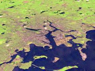
12 Module 3 Educator s Guide Investigation 2 What is there to see from sea to shining sea? Investigation Overview This investigation builds on the first investigation in this module. Students locate and identify physical and human-made features in the United States using images from space and create their own U.S. maps that are illustrated with NASA images. The song America the Beautiful is used to help students recognize that our country has many different regions and that the landscape of our country is very diverse. Time required: Two 45-minute sessions Materials/Resources Atlases or U.S. maps (one for each group of four) Log 1: How many physical and human-made features can you find? (one for each group of four) Log 2: What features make our country a special place? (one for each group of four) Log 3: What features make our country a special place? (answer page) (one for each group of four) Log 4: Sea to shining sea Images (one for each student) Poster board (one for each group) Masking tape Wall map Content Preview Places on Earth are characterized by their physical and human properties. Their natural physical features include climate, landforms, soils, bodies of water, vegetation, and animal life. Their human characteristics include language, religion, political systems, economic systems, population distribution, and the features people construct such as cities, airports, roads, bridges, and canals. Both natural environmental features and humanmade features are visible from space. Geography Standards Standard 1: The World in Spatial Terms How to use maps and other geographic representations, tools, and technologies to acquire, process, and report information from a spatial perspective Identify and describe the characteristics and purposes of geographic representation, tools, and technologies. Standard 4: Places and Regions The physical and human characteristics of places Use a variety of graphic materials and data sources to describe the physical and human characteristics of a region. Geography Skills Skill Set 2: Acquire Geographic Information Make and record observations about the physical and human characteristics of places. Skill Set 4: Analyze Geographic Information Use texts, photographs, and documents to observe and interpret geographic trends and relationships. Classroom Procedures Beginning the Investigation 1. Divide students into groups of four and give each group an atlas and a copy of Log 1. Review the definition of physical and human-made features. (Physical features describe the natural features of the land such as landforms and water bodies, and human-made features are the characteristics of a place or region that are made by people.) Tell them to look carefully at the satellite image and ask if anyone can identify the city. It is San Francisco, California. Now tell students to locate San Francisco on the wall map and describe its location. (On 1
13 Module 3 Educator s Guide Investigation 2 the west coast, near the Pacific Ocean, on a bay, etc.) Have them list the kinds of physical and human-made features they can see in the satellite image. Discuss and compare their lists. 2. Have the students find a physical map of the United States in the atlas and help them to identify the physical features they see on the map by name. (Various mountain ranges, major lakes and rivers, deserts, etc.) If the wall map shows these features, there is no need to use the atlases. Developing the Investigation 3. Divide the class into groups and give each group an atlas and a copy of Logs 2 and 3. Tell the students to cut out the three boxes in Log 3 and match them to the three correct images in Log 2. Have the students look at the images and discuss the kinds of physical and human-made features they can see. Ask them to determine whether the features are mostly physical or mostly humanmade and circle the answer. Then have them list examples of these features. When students have completed the activity, discuss their answers. 4. Tell the students that about 100 years ago Katharine Lee Bates wrote a poem which later was made into a song by Samuel A. Ward. This song describes the United States wide skies, rich farmlands, mountains, and more. Ask if anyone can name the song. Have the class sing America the Beautiful. America the Beautiful O beautiful for spacious skies, For amber waves of grain, For purple mountain majesties Above the fruited plain! America! America! God shed His grace on thee And crowned thy good with brotherhood From sea to shining sea! 5. Use the wall map to discuss the song. Have students help identify the places in the United States that we associate with amber waves of grain (the Great Plains); purple mountain majesties (coastal ranges, Sierra Nevadas, Cascades, Rockies, Appalachians); the fruited plain (southeastern coastal plain including Florida). Concluding the Investigation 6. Have the students work in their groups to draw an outline map of the United States on a large posterboard using an overhead projector. Instruct them to cut out the images from Log 4. Have them work in small groups to decide where each image belongs on their maps. They should check the locations on the wall map or in an atlas. Have each group attach its images on the posterboard map with tape. Discuss the map as a class and correct any misplaced images. This activity can be extended by having students affix magazine pictures and postcards to the map. 7. Ask each group to collaborate and write a poem that will describe the images on the map. Suggest that they identify and describe the geographic features they learned about, and that they include information on ways we can protect our country s environment from sea to shining sea. Display the poems in the classroom. Evaluation *Log 1: How many physical and human-made features can you find? Physical features: bay, ocean, strait, peninsula, island Human-made features: city, buildings, bridges, streets, parks, roads, airport *Log 3: What features make our country a special place? Grand Canyon image #1 Lanai, Hawaii image #4 Lake Michigan and Chicago, Illinois image #6 *Log 4: Sea to shining sea 1. San Francisco 2. Mount Rainier 3. Sonoran Desert 4. Great Salt Lake Salt Lake City 5. Rocky Mountains 6. Albuquerque, New Mexico 7. New Orleans 8. Great Lakes 9. Cape Canaveral, Florida 10. Chesapeake Bay 11. New York City 2
14 Module 3, Investigation 2: Log 1 How many physical and human-made features can you find? Name Date Physical Features Human-Made Features 1 3

15 Module 3, Investigation 2: Log 2 What features make our country a special place? Directions: Cut out the boxes on Log 3. Match them to the three correct images

16 Module 3, Investigation 2: Log 2 What features make our country a special place?


17 Module 3, Investigation 2: Log 2 What features make our country a special place?
18 Module 3, Investigation 2: Log 3 What features make our country a special place? Name Date Directions 1. After you have matched the satellite images, look at each image to see if it has mostly physical or mostly human-made features. Circle your answer. 2. Identify the kinds of physical and human-made features you can see. Grand Canyon, Arizona 1) Mostly Physical Mostly Human-Made 2) Identify the features you see: Physical Human-Made Lanai Island, Hawaii 1) Mostly Physical Mostly Human-Made 2) Identify the features you see: Physical Human-Made Lake Michigan and Chicago, Illinois 1) Mostly Physical Mostly Human-Made 2) Identify the features you see: Physical Human-Made 7 5


19 Module 3, Investigation 2: Log 4 Sea to shining sea Images Rocky Mountains Cape Canaveral, Florida San Francisco, California, and surrounding areas Salt Lake City, Utah, and Great Salt Lake The Great Lakes 6 8


20 Module 3, Investigation 2: Log 4 Sea to shining sea Images Long Island, New York Albuquerque, New Mexico New Orleans, Louisiana, and Lake Pontchartrain Chesapeake Bay Mount Rainier, Washington 9 7 Southwest corner of the Sonoran Desert
21 Module 3 Educator s Guide Investigation 3 How do images help us learn about our planet Earth? Investigation Overview Students interpret a nighttime image of the world using the distribution of lights to identify broad patterns of world population. They use maps of landforms and climate to help explain these patterns. Time required: One 45-minute session Materials/Resources Figure 1: Nighttime lights of the world (transparency and student copies) Log: True or false? Globe 1 apple (as round as possible, or if allowed, Terry s Chocolate Orange) Knife Atlases (one per group of students) Geography Standards Standard 1: The World in Spatial Terms How to use maps and other geographic representations, tools, and technologies to acquire, process, and report information from a spatial perspective Identify and describe the characteristics and purposes of geographic representations, tools, and technologies. Standard 17: The Uses of Geography How to apply geography to interpret the past Describe how the physical and human characteristics of places change over time. Content Preview The nighttime lights of the world illustrate the uneven distribution of the world s population. In the image, light is evidence of large numbers of people; dark indicates the absence of people. Settlements are clustered near water and other resources needed for transportation and economic activities. Classroom Procedures Beginning the Investigation 1. Where Do People Live? Tell students that you will use an apple to help them see why people live where they do. Show an apple and tell them it represents Earth. Ask them to compare this shape to a globe and note that even the roundest apple is not a sphere, like a globe. An orange would be better but is difficult to cut into small slices. Note: If candy is allowable, use Terry s Chocolate Orange which is precut into slices. Ask the students to look at a globe and guess on what portion of Earth people live: more than half or less than half? Quarter the apple; place three-quarters in one hand, one-quarter in the other. Explain that the three-quarters represents water. Nearly threequarters of Earth s surface is covered with water. No one can live there. Set these pieces aside. Hold up the fourth quarter. It represents land. 1
22 Module 3 Educator s Guide Investigation 3 Ask the students to guess what portion of the land is too cold, too dry, too wet, or too mountainous for people to live on. (About half.) Slice the quarter apple lengthwise in half and set aside one of the slices. The remaining slice an eighth of the apple represents the area of Earth on which the human population lives. Developing the Investigation 2. Next show students the transparency of the figure: Nighttime lights of the world. Ask them what the white dots might represent. Explain that they are the lights of towns and cities. Lights are evidence of large numbers of people; dark means few people. Note the clustering of people in certain parts of the world. In some places, there are so many people that large areas are lit up. Have the students take turns pointing out the continents and discuss whether each continent has a large or small population. Are these populations clustered in particular places? If so, where? 3. Place the students in small groups and give each group an atlas and a copy of the Log. Tell students to cut out the sentence strips. Next, they read the facts on the strips and determine which strips contain true facts about the nighttime lights and place them in one group. The other groups of strips contain information that is not true about the image. Tell students to look carefully at the image and discuss the information before making their decision. They may need to look up the locations in their atlases in order to find them on the image. Discuss their decisions when the groups have completed the activity. Concluding the Investigation 4. Tell the students to look again at the figure: Nighttime lights of the world and to point to places where there are not many lights. Give each group an atlas, and assign each group a continent. Have them identify landforms and climate characteristics on their continents and speculate with the whole class whether those features would deter people from living there. On the board write the names of the continents and under each continent list the physical features in the unpopulated areas as students identify them. North America mountains, forests, deserts, lakes South America mountains, forests, desert Africa desert, forests, mountains Europe mountains, tundra Asia mountains, desert, tundra, lakes (Be certain that the students understand the definition of desert and tundra.) Background The nighttime lights of the world dataset contains the first satellite-based global inventory of human settlements, derived from nighttime data from the Defense Meteorological Satellite Program (DMSP) and Operational Linescan System (OLS). The DMSP-OLS has the unique capability to observe faint sources of visiblenear infrared emissions present at Earth s surface, including cities, towns, villages, gas flares, and fires. Lights in the Gulf of Mexico are not people and cities. What you see are flares from the burn-off of offshore oil and natural gas fields. This can be explained to the students as appropriate. Evaluation *Log True statements: There are more lights east of the Mississippi River than west of it. There are very few lights in the Amazon Basin region of South America. Many lights can be seen on the continent of Europe. Most of the cities in Asia are along the coastlines. False statements: Africa has many lights in the center of the continent. In the middle of Australia there are many big cities. Additional Resources Geography from Space This free video resource guide contains background material and classroom activities related to the geography and geology of North and South America, Europe, Asia, Africa, and Australia as seen from the vantage point of orbit. The free videotape to accompany this guide may be ordered from NASA CORE at education.nasa.gov/. Originally appeared in Kiutatk, A Native American Science Education Association Issue Publication, and is adapted from Earth: The Apple of Our Eye, People and the Planet: Lessons for a Sustainable Future, Zero Population Growth, Inc., 1996 Adapted from Geography Awareness Week 98 2

23 Module 3, Investigation 3: Figure 1 Nighttime lights of the world Circle the continents on this image. Source: 1 3
24 Module 3, Investigation 3: Log True or false? Name Date Directions: Cut out each of the strips. Sort the strips into two groups: true statements about the nighttime lights image and false statements about the image. Look carefully at the image and discuss the information. Refer to your student atlas for help. Africa has many lights in the center of the continent. There are more lights east of the Mississippi River than west of it. There are very few lights in the Amazon Basin region of South America. Many lights can be seen on the continent of Europe. In the middle of Australia there are many big cities. Most of the cities in Asia are along the coastlines. 2 4
25 Module 3 Educator s Guide Investigation 4 Where are the cities? Investigation Overview Students compare an image showing nighttime lights in the United States with atlas maps in order to identify major cities and relate population distribution patterns to the physical environment. By locating cities and physical features identified in the nighttime image on an outline map, students become more familiar with important locations in the United States. They also use atlas maps and geographic information to identify NASA images of areas around several major cities. Time required: Two 45-minute sessions Materials/Resources Atlas maps or U.S. wall maps showing landforms and vegetation Outline map of the United States (copy for each student) Figure 1: Nighttime lights of the continental United States (make an overhead transparency and one copy for each group of 3 students) Log 1: Understanding the nighttime lights (one for each group of 3) Log 2: Where are these cities? Questions (one for each group of 3) Log 3: Where are these cities? Space Shuttle photographs (one for each group of 3) Light blue crayon, red crayon Geography Standards Standard 1: The World in Spatial Terms How to use maps and other geographic representations, tools, and technologies to acquire, process, and report information from a spatial perspective Identify and describe the characteristics and purposes of geographic representations, tools, and technologies. Standard 5: Places and Regions That people create regions to interpret Earth s complexity Predict the consequences of a specific physical process operating on Earth s surface. Content Preview Population in the United States is unevenly distributed. Physical features such as mountains and deserts have discouraged settlement in some areas while features such as lakes, rivers, and coastlines make other locations more attractive to settlers. The United States is more densely populated in the East because of historical settlement patterns and physical geography. Classroom Procedures Beginning the Investigation 1. Distribute outline maps of the United States to each student and speculate with the students about where in the United States most people live. Ask them where they think the big cities are located. 2. Tell students that in earliest times people lived in rural areas and small communities. Explain how the growth of industry enabled some of these communities to grow into big cities. Explain that there were several reasons why sites developed into cities. Ask the students to think of reasons why specific places make good sites for cities. (Protected harbor, fresh water available, easy to reach, easy to defend, streams or river for water power and transportation, raw materials for industry, etc.) 1
26 Module 3 Educator s Guide Investigation 4 Developing the Investigation 3. Divide the class into groups of three. Give each group an atlas and a copy of Figure 1 and Log 1. Ask the students what they think the white areas represent. (They are lights that have been identified by satellites. They show where large towns and cities are located.) Use the information in the Background section for more details, as appropriate. Explain that larger areas of light mean larger cities. Ask the students to describe how the U.S. population is distributed. (More people in the eastern half; most along the coastlines, etc.) Tell students to try to find the location of their home town on this map. Ask them if it is in a white area or a dark area. 4. Ask each group to use Figure 1, an outline map of the United States, and their atlases to answer the questions in Log 1. Have the whole class discuss the answers. Concluding the Investigation 5. Where are these cities? Keep students in their groups and tell them that they will continue to use the atlas, the map, and Figure 1. Give each group a copy of Log 2 (Where are these cities? Questions), and Log 3 (Where are these cities? Space Shuttle photos). Write the names of the cities on the board: Boston, Massachusetts; Detroit, Michigan; Pittsburgh, Pennsylvania; San Francisco, California; Minneapolis, Minnesota; and Miami, Florida. Have students locate these cities in the atlas and follow the directions in Log 2, questions 1 and 2. Then explain that the clues in question 3 refer to the images in Log 3. Explain that these are Space Shuttle images that show the physical environments around each city. Ask the students to use the clues and their atlases to identify each city. After the students have identified the cities, discuss the physical features that might have contributed to making each city a good settlement site. Evaluation Answer Key *Log 1: Understanding the Nighttime Lights 2. To the east 3. Minneapolis, St. Louis 5. Easy transportation on the lakes, water for people and industry 9. The lights come together 10. Chicago, Milwaukee Log 3: Where are these cities? Space Shuttle photographs a. San Francisco, California b. Boston, Massachusetts c. Detroit, Michigan d. Miami, Florida e. Pittsburgh, Pennsylvania f. Minneapolis, Minnesota Background On the nighttime lights of the continental United States image: light is evidence of towns and cities; dark means the absence of towns and cities. You will see great clusters of cities from Boston to New York, Philadelphia, Baltimore, and Washington. This is the original megalopolis. The nighttime lights of the world dataset contains the first satellite-based global inventory of human settlements, derived by nighttime data obtained by the Defense Meteorological Satellite Program (DMSP) and Operational Linescan System (OLS). The DMSP-OLS has the unique capability to observe faint sources of visible-near infrared emissions present at Earth s surface, including cities, towns, villages, gas flares, and fires. Lights in the Gulf of Mexico are flares from the burn-off of oil and natural gas fields. Resources BIOMASS/usa.html Nighttime lights of continental United States boston.html Boston, Massachusetts detroit.html Detroit, Michigan pittsburgh.html Pittsburgh, Pennsylvania downtown_minneapolis.jpg Minneapolis, Minnesota san_francisco.html San Francisco, California miami.html Miami, Florida 2

27 Module 3, Investigation 4: Figure 1 Nighttime lights of the continental United States Name Date Source: 1 3
28 Module 3, Investigation 4: Log 1 Understanding the nighttime lights 1. Draw a blue line on the outline map where the Mississippi River is located. (Find the location in the atlas.) 2. Figure out where the Mississippi River is on the image and draw a blue line there, too. Are there more cities to the east or west of the Mississippi River? 3. Color the two brightest lights along the Mississippi River red. Use the atlas to find out which two cities you picked. 4. Make a small circle to show each city on the outline map and label them. 5. Color the Great Lakes blue on the outline map and label them. Use the atlas to find the big cities on each lake. Mark and label them on the map. Circle these cities in Figure 1. Why do you think cities developed along the Great Lakes? 6. Find the Rocky Mountains, the Appalachian Mountains, the Sierra Nevada Mountains, the Cascades Range, and the Coastal Ranges in the atlas. Label them on the outline map. 7. Find the desert areas of the west and southwest in the atlas. Mark and label them on the outline map. 8. Can you find the mountains and the dry areas in the nighttime image? Circle them with the blue crayon. 9. A megalopolis is a giant city. It occurs when individual cities grow so big that they merge together. Locate Boston, New York City, Philadelphia, Baltimore, and Washington, D.C., in the atlas. Mark and label them on the map and color them red on the image. What pattern do you see on the image? 10.Find another megalopolis on the image at the south end of Lake Michigan and color it red. Mark and label two cities in this megalopolis on the map. 2 4
29 Module 3, Investigation 4: Log 2 Where are these cities? Questions Name Date Geographers, scientists, and planners are just a few of the people who look at population and ask, Where are people? Where are the cities? Now it s your turn to look at a map that shows us many cities and decide what makes some places good for large and dense settlements. To do this, complete the investigation below: 1. Images on Log 3 are of the following cities: Boston, Massachusetts Detroit, Michigan Pittsburgh, Pennsylvania San Francisco, California Minneapolis, Minnesota Miami, Florida 2. Locate these cities in the atlas. Then mark and label them on your outline map. Circle them on the nighttime image (Figure 1). 3. Look at the NASA images of these cities in Log 3 and see if you can identify them. Use the atlas and the clues below to help you match the cities and the images. Write the name of each city in the space next to the image. a. This city is on a bay on the Pacific Ocean. b. This city is in New England, on Massachusetts Bay. c. This city is on a river between Lake Huron and Lake Erie. d. This city is in the southeastern United States on the Atlantic Ocean. e. This city is located west of the Appalachian Mountains where the Ohio and Allegheny Rivers meet to form the Monongahela River. f. This city is the northernmost port on the Mississippi River. 3 5


30 Module 3, Investigation 4: Log 3 Where are these cities? Space Shuttle photographs a. b. c. d. e. f. 6 4
Module 2 Educator s Guide Overview
 Module 2 Educator s Guide Overview Water, water almost everywhere? Module Overview The presence of water in solid, liquid, and gaseous forms is one of the primary factors that distinguishes Earth from
Guided Reading Activity
 Guided Reading Activity Lesson 1 Physical Features Essential Question: How does geography influence the way people live? A Vast Land Directions: Read the lesson and use your text to decide whether each
Unit 1: Geography. For additional information, refer to this website: 1 G e o g r a p h y
 Unit 1: Geography For additional information, refer to this website: http://mryoungtms.weebly.com/ 1 G e o g r a p h y Continents and Oceans SOL USI. 2a Essential Understanding: Continents are large land
Module 2 Educator s Guide Investigation 2
 Module 2 Educator s Guide Investigation 2 How does remote sensing help us to observe human activities on Earth? Investigation Overview Landscapes that are influenced by human activities are found nearly
HI SUMMER WORK
 HI-201 2018-2019 SUMMER WORK This packet belongs to: Dear Dual Enrollment Student, May 7 th, 2018 Dual Enrollment United States History is a challenging adventure. Though the year holds countless hours
Module 4 Educator s Guide Overview
 Module 4 Educator s Guide Overview Paths Module Overview This module looks at many different kinds of paths and considers why paths are where they are and how they look from space. Paths are usually not
About places and/or important events Landmarks Maps How the land is, hills or flat or mountain range Connected to maps World Different countries
 What do you think you know about geography? About places and/or important events Landmarks Maps How the land is, hills or flat or mountain range Connected to maps World Different countries What do you
CHAPTER 1. Geo Challenges 1A to 1D. & World Map Activity
 CHAPTER 1 Geo Challenges 1A to 1D & World Map Activity SELECT YOUR CHALLENGE World Map Activity Challenge 1A Challenge 1B Challenge 1C Challenge 1D Challenge 1A WS PG. 2 STEP #1 Label the largest continent
Essential Questions What are the major physical components of the world, and how are they represented on a map? 3.4
 Third Grade Social Studies Unit One Six Weeks GEOGRAPHY Originally compiled by Russellville In order for students to understand that geography influences the development of a region as well as the interactions
North American Geography. Lesson 2: My Country tis of Thee
 North American Geography Lesson 2: My Country tis of Thee Unit Overview: As students work through the activities in this unit they will be introduced to the United States in general, different regions
Chapter 1. Social Studies History and Geography
 Chapter 1 Social Studies History and Geography Unit 01 Geography Skills 1 Reading Maps Key Words border landform rely on display focus on route locater 1 There are many different kinds of maps. A political
4th Grade Social Studies First Nine Weeks
 4th Grade Social Studies First Nine Weeks Multiple Choice Identify the choice that best completes the statement or answers the question. 1 Name the mountains that are located in the eastern United States.
Grade 7 History Mr. Norton
 Grade 7 History Mr. Norton Section 1: Thinking Geographically Section 2: Land and Climates of the United States Section 3: The Tools of History Section 4: Economics and Other Social Sciences Grade 7 History
Many Ways to Name a Place
 Your web browser (Safari 7) is out of date. For more security, comfort and Activityapply the best experience on this site: Update your browser Ignore Many Ways to Name a Place What are the names for the
Five Themes of Geography Project Ms. Kiesel, Per 5. The United States of America
 Five Themes of Geography Project Ms. Kiesel, Per 5 The United States of America Location Absolute Location : The USA is located in the continent of North America in the northern and western hemispheres.
2 Georgia: Its Heritage and Its Promise
 TERMS region, erosion, fault, elevation, Fall Line, aquifer, marsh, climate, weather, precipitation, drought, tornado, hurricane, wetland, estuary, barrier island, swamp PLACES Appalachian Mountains, Appalachian
A. Geography Students know the location of places, geographic features, and patterns of the environment.
 Learning Targets Elementary Social Studies Grade 5 2014-2015 A. Geography Students know the location of places, geographic features, and patterns of the environment. A.5.1. A.5.2. A.5.3. A.5.4. Label North
Elementary Social Studies Content Area Assessment Task. Winter 2010 EDUC 203
 1 Elementary Social Studies Content Area Assessment Task Winter 2010 EDUC 203 Students: Fourth grade class in Watsonville, CA. Approximately 90% Latino, primarily of Mexicandescent. About 80% participate
Unit 1 -Lesson 5. Population Patterns of the Eastern Hemisphere
 Unit 1 -Lesson 5 Population Patterns of the Eastern Hemisphere Population Patterns of the Eastern Hemisphere Population Patterns of the Eastern Hemisphere Big Ideas of the Lesson Population distribution
Map Skills Lesson 1. Materials: maps, pencils, Lesson 1 Worksheet, strips of paper, grid paper
 Map Skills Lesson 1 Use cardinal directions, map grids, scales, and titles to locate places on a map. Interpret a map using information from its title, compass rose, scale, and legend. Vocabulary: map,
Why Do We Live Here? : A Historical Geographical Study of La Tabatiere, Quebec North Shore
 Why Do We Live Here? : A Historical Geographical Study of La Tabatiere, Quebec North Shore Lesson Overview Many communities and their occupants have historical connections to exploration routes and traditional
Chapter 1: America s Land Lesson 1: Land and Climate
 Chapter 1: America s Land Lesson 1: Land and Climate Geography: Describe landforms and other physical features of the United States. Geography: Explain how and why climate varies throughout the United
Geography and the Early Settlement of China
 Geography and the Early Settlement of I N T E R A C T I V E S T U D E N T N O T E B O O K How did geography affect life in ancient? P R E V I E W Physical Features 1. Circle the physical features that
MARS AREA SCHOOL DISTRICT CURRICULUM GRADE: Grade 4
 MARS AREA SCHOOL DISTRICT CURRICULUM GRADE: Grade 4 Course Title: Social Studies Brief Description Overview: Students will explore the history, geography, government, and economy of the United States with
MR. JOHNSON S. Geography OHIO COUNTY MIDDLE SCHOOL
 MR. JOHNSON S Geography OHIO COUNTY MIDDLE SCHOOL CHAPTER 1 Geography The science of geography is likely the oldest of all sciences. Geography is the answer to the question that the earliest humans asked,
The Wedding of the Rails
 The Wedding of the Rails Anne Burkhalter Gilbert Elementary School aburkhalter@lexington1.net Overview Students will learn about the Transcontinental Railroad its importance in settling the west, as well
Range of Opportunities
 Geograhy Curriculum Cropwell Bishop Primary School Range of Opportunities Year 1 Year 2 Year 3 Year 4 Year 5 Year 6 All Key Stage 1 Key Stage 2 Investigate the countries and capitals of the United Kingdom.
Critical Thinking. about. GeoGRAPHY. United States, Canada, and Greenland. Jayne Freeman
 Critical Thinking about GeoGRAPHY United States, Canada, and Greenland Jayne Freeman WALCH EDUCATION Contents Introduction............................................................... v National Geography
Unit 2. United States Physical Geography
 Unit 2 United States Physical Geography Physical Geography U.S. extends from the Atlantic to Pacific U.S. is the 3rd largest country U.S. has fertile soils, vast forests, and variety of minerals All major
Unit 1: Geography CLASS WEBSITE: QUIZLET GAMES: ONLINE RESOURCES
 Unit 1: Geography ONLINE RESOURCES CLASS WEBSITE: HTTPS://MRYOUNGTMS.WEEBLY.COM/GEOGRAPHY.HTML QUIZLET GAMES: HTTPS://QUIZLET.COM/JOIN/MSFYY94T5 1 G e o g r a p h y Continents and Oceans The Seven Continents
Geographical knowledge and understanding scope and sequence: Foundation to Year 10
 Geographical knowledge and understanding scope and sequence: Foundation to Year 10 Foundation Year 1 Year 2 Year 3 Year 4 Year 5 Year 6 Year level focus People live in places Places have distinctive features
Module 2, Investigation 1: Briefing Where do we choose to live and why?
 Module 2, Investigation 1: Briefing Background Why do you live where you live? Where do people choose to live? Why do they choose those places? People have lived on Earth for thousands of years. Throughout
a division of Teacher Created Materials
 Sample Pages from a division of Teacher Created Materials Thanks for checking us out. Please call us at 877-777-3450 with questions or feedback, or to order this product. You can also order this product
FIRST GRADE 1 WEEK LESSON PLANS AND ACTIVITIES
 FIRST GRADE 1 WEEK LESSON PLANS AND ACTIVITIES UNIVERSE CYCLE OVERVIEW OF FIRST GRADE UNIVERSE WEEK 1. PRE: Describing the Universe. LAB: Comparing and contrasting bodies that reflect light. POST: Exploring
ELEMENTS OF BASIC WORLD GEOGRAPHY TABLE OF CONTENTS UNIT 1 THE BASICS OF GEOGRAPHY AND NORTH AMERICA
 TABLE OF CONTENTS UNIT 1 THE BASICS OF GEOGRAPHY AND NORTH AMERICA IMPORTANT WORDS TO KNOW... 1 CHAPTER 1 THE BASICS OF GEOGRAPHY GEOGRAPHY... 2 TOOLS OF GEOGRAPHY... 3 EARTH...4 SEASONS, CLIMATE, AND
name and locate the world s seven continents and five oceans
 Subject: Geography Activities National Curriculum Objectives One Progression of Skills Name the 7 continents and 5 oceans 3D Jigsaw task to locate continents and seas name and locate the world s seven
How Geographers View the World: Human Geography. ESSENTIAL QUESTION: How does geography influence the way people live?
 How Geographers View the World: Human Geography ESSENTIAL QUESTION: How does geography influence the way people live? Geographers Think Spatially Gefffffdgfhfjgjp Guiding Question: What does it mean to
4th Grade U.S. Regional Geography
 4th Grade U.S. Regional Geography Multiple Choice Identify the choice that best completes the statement or answers the question. What does the term mainland mean in the sentence above? A the continent
The United States & Canada. A Regional Study of Anglo America
 A Regional Study of Anglo America Landform Regions of the United States & Canada world leaders in agricultural and industrial production because of... VAST LANDS stretch from the Atlantic Ocean on the
Five Themes of Geography of Ecuador
 LESSON 1 Five Themes of Geography of Ecuador Lesson Objective The students will be able to: find the five themes of geography (location, movement, human/environment interaction, place, and region) of Ecuador
Simple Solutions Social Studies Level 2. Level 2. Social Studies. Help Pages
 Level 2 Social Studies 147 148 adobe houses with bricks made of clay and straw ancestor a family member who lived before us appoint choose; leaders can appoint others barter trading one thing for another
North America ATLANTIC OCEAN PACIFIC OCEAN. The First Americans. Labrador Sea. Caribbean Sea. USI_ISN_U01_01.eps. Second Proof TCI19 65.
 G e o g r a p h y C h a l l e n g e North America 70 N 180 N 60 170 W 30 W 160 W 40 W Labrador Sea 150 W 50 N 50 W Hud s on B ay 140 W 40 N 60 W ATLANTIC OCEAN 30 N PACIFIC OCEAN Gulf of Mexico 20 N 130
World Geography. BY MARK STANGE and REBECCA LARATTA
 BY MARK STANGE and REBECCA LARATTA COPYRIGHT 2002 Mark Twain Media, Inc. ISBN 1-58037-205-8 Printing No. CD-1551 Mark Twain Media, Inc., Publishers Distributed by Carson-Dellosa Publishing Company, Inc.
Looking at Communities: Comparing Urban and Rural Neighborhoods
 Looking at Communities: Comparing Urban and Rural Neighborhoods OVERVIEW & OBJECTIVES Our urban areas have become so dominant that frequently the children we teach have no connection with and very few
Geography Long Term Plan 2018
 Geography Long Term Plan 2018 Geography Co-ordinator: Megan Frost A high-quality geography education should inspire in pupils a curiosity and fascination about the world and its people that will remain
Standard Indicator That s the Latitude! Students will use latitude and longitude to locate places in Indiana and other parts of the world.
 Standard Indicator 4.3.1 That s the Latitude! Purpose Students will use latitude and longitude to locate places in Indiana and other parts of the world. Materials For the teacher: graph paper, globe showing
[ 1.2 ] Texas Geography
![[ 1.2 ] Texas Geography](/thumbs/78/78091378.jpg "[ 1.2 ] Texas Geography") [ 1.2 ] Texas Geography [ 1.2 ] Texas Geography Learning Objectives Identify how geography helps people understand and organize information about a place. Compare the physical and human characteristics
[ 1.2 ] Texas Geography [ 1.2 ] Texas Geography Learning Objectives Identify how geography helps people understand and organize information about a place. Compare the physical and human characteristics
MEADOWS PRIMARY SCHOOL and NURSERY GEOGRAPHY POLICY
 MEADOWS PRIMARY SCHOOL and NURSERY GEOGRAPHY POLICY Purpose of study The teaching of Geography at Meadows is done by following the 2014 National Curriculum. The planning and teaching of the subject aims
EQ: Discuss main geographic landforms of the U.S. & Canada and examine varied landforms in relation to their lifestyles.
 EQ: Discuss main geographic landforms of the U.S. & Canada and examine varied landforms in relation to their lifestyles. Places & Terms for Discussion Appalachian Mountains Great Plains Canadian Shield
Module 2 Educator s Guide Investigation 4
 Module 2 Educator s Guide Investigation 4 How do water bodies change over time? Investigation Overview Students explore how water bodies change in response to changes in weather and climate. They do experiments
Think about the landforms where you live. How do you think they have changed over time? How do you think they will change in the future?
 reflect All the landforms on Earth have changed over time and continue to change. Many of the changes were caused by wind, moving water, and moving ice. Mountains have grown and shrunk. Rivers have cut
American Tour: Climate Objective To introduce contour maps as data displays.
 American Tour: Climate Objective To introduce contour maps as data displays. www.everydaymathonline.com epresentations etoolkit Algorithms Practice EM Facts Workshop Game Family Letters Assessment Management
discussion of North America s physical features, including its landforms and bodies of
 Chapter 7 Natural Environments of North America Chapter 7 focuses on the natural environments of North America. The chapter opens with a discussion of North America s physical features, including its landforms
Fourth Grade Social Studies
 AASD SOCIAL STUDIES CURRICULUM Fourth Grade Social Studies Description Fourth Grade Social Studies explores the regions of the United States with particular emphasis on the where students will spotlight
Ancient China UNIT 4 GEOGRAPHY CHALLENGE. 1 Unit 4 Geography Challenge. Teachers Curriculum Institute
 UNIT 4 GEOGRAPHY CHALLENGE Ancient China N W E S 0 250 500 miles 0 250 500 kilometers Albers Conic Equal-Area Projection AW_ISN_U04_01 Ancient China Second Proof TCI18 108 1 Unit 4 Geography Challenge
Visit us at...
 Thanks for your purchase. We hope you are pleased. We think you might like the website that we are working on. You will find websites that go along with your unit and word wall cards. We hope you enjoy.
Module 7, Lesson 1 Water world
 Module 7, Lesson 1 Water world Imagine that the year is 2100. Scientists have determined that the rapidly warming climate of the earth will cause the ice sheets of Antarctica to break apart and melt at
Kindergarten: Foundations of Social Studies
 4. Governmental Institutions and Political Processes 1. Citizenship and Government 2. Civic Values and Principles of Democracy 1.Civic Skills indergarten: Foundations of Social Studies In kindergarten,
High School World History Cycle 2 Week 2 Lifework
 Name: Advisory: Period: High School World History Cycle 2 Week 2 Lifework This packet is due Monday, November 7 Complete and turn in on Friday for 10 points of EXTRA CREDIT! Lifework Assignment Complete
Changes to Land 5.7B. landforms: features on the surface of Earth such as mountains, hills, dunes, oceans and rivers
 All the landforms on Earth have changed over time and continue to change. Many of the changes were caused by wind, moving water, and moving ice. Mountains have grown and shrunk. Rivers have cut away land
Geography Progression
 Geography Progression This document aims to track expectations for History within George Grenville Academy. What the National Curriculum says: KS1: Locational Knowledge: Name and locate the world s 7 continents
Physical Geography of the United States and Canada Chapter 5 A Land of Contrasts
 Physical Geography of the United States and Canada Chapter 5 A Land of Contrasts Land Area Together the U.S. and Canada cover more than 7 million square miles. In total area, Canada ranks 2 nd and the
What is a landform? These shapes (except for bodies of water) on the earth s surface are all examples of landforms.
 on the earth s surface are all examples of landforms.") Landforms What is a landform? These shapes (except for bodies of water) on the earth s surface are all examples of landforms. archipelago a large group of many islands. The Hawaiian Islands Lighthouse
Landforms What is a landform? These shapes (except for bodies of water) on the earth s surface are all examples of landforms. archipelago a large group of many islands. The Hawaiian Islands Lighthouse
Your web browser (Safari 7) is out of date. For more security, comfort and. the best experience on this site: Update your browser Ignore
 is out of date. For more security, comfort and. the best experience on this site: Update your browser Ignore") Your web browser (Safari 7) is out of date. For more security, comfort and lesson the best experience on this site: Update your browser Ignore Political Borders Why are the borders of countries located
Your web browser (Safari 7) is out of date. For more security, comfort and lesson the best experience on this site: Update your browser Ignore Political Borders Why are the borders of countries located
Your web browser (Safari 7) is out of date. For more security, comfort and the best experience on this site: Update your browser Ignore
 is out of date. For more security, comfort and the best experience on this site: Update your browser Ignore") Your web browser (Safari 7) is out of date. For more security, comfort and the best experience on this site: Update your browser Ignore Activityengage MAPPING W O RL D HERITAGE Where are sites of significant
Your web browser (Safari 7) is out of date. For more security, comfort and the best experience on this site: Update your browser Ignore Activityengage MAPPING W O RL D HERITAGE Where are sites of significant
World Geography. Teacher s Guide
 World Geography Teacher s Guide WALCH PUBLISHING Table of Contents To the Teacher.......................................................... vi Classroom Management.................................................
Module 3 Educator s Guide Overview
 Module 3 Educator s Guide Overview Human footprints on Earth as seen by NASA scientists Module Overview This module draws upon NASA images and research to introduce students to the various ways humans
6/25/2018. Upcoming Classes After Today. Our Only Presentation Day: Monday, July 2
 Upcoming Classes After Today Tuesday (June 26): Pacific Northwest and the Northlands Wednesday (June 27): Geographic Literacy in America; Take-Home Midterm Exam #2 distributed and discussed Thursday (June
Geography Route Planner
 Geography Route Planner Introduction to Route Planners Route Planners outline the Key Stages 1-3 curriculum to be taught within each campus of the Bury St Edmunds Trust. Each Route Planner has been designed
Did You Ever Wonder? Landforms, C52. Slow Changes on Land, C58. Fast Changes on Land, C68
 \ - i -Vt1 t _ 9 \ "» y \R Landforms, C52 Slow Changes on Land, C58 Fast Changes on Land, C68 w -4 Did You Ever Wonder? What forces shaped these rocks? Wind and rain shaped them over thousands of years.
Unit 1: Basics of Geography Test Review
 Name Date Period Unit 1: Basics of Geography Test Review Directions: Reading the following sections and complete the questions, charts, and diagrams. Types of Maps Maps that have a particular theme are
K- 5 Academic Standards in. Social Studies. June 2013
 K- 5 Academic s in Social Studies June 203 Word Tables of s ONLY This Word version of the 2.7.2 social studies standards (DRAFT for Rulemaking 2.7.2) document contains the standards ONLY; no explanatory
Maryland Council on Economic Education 1
 How to Make an Apple Pie and See the World by Marjorie Priceman (Dragonfly Books, New York, 1994) ISBN 0-679-88083-6 Literature Annotation: This beautifully illustrated story is about a girl baker who
Passwords. Social Studies Vocabulary. Texas: Grade 7
 Passwords Social Studies Vocabulary Texas: Grade 7 To the Student What is federalism? How are independence and interdependence different? What does an anthropologist do? Passwords: Social Studies Vocabulary
DRAWING YOUR CONTINENT
 CONTINENT PROJECT PART I On the attached sheet, you will draw your own continent. Use your creativity to create a continent that is uniquely your own. Give the continent a name. When you are finished with
Chapter 6, Part Colonizers arriving in North America found extremely landscapes. It looked different to region showing great.
 Social Studies 9 Unit 1 Worksheet Chapter 6, Part 1. 1. Colonizers arriving in North America found extremely landscapes. It looked different to region showing great. 2. The Earth is years old and is composed
Your web browser (Safari 7) is out of date. For more security, comfort and. the best experience on this site: Update your browser Ignore
 is out of date. For more security, comfort and. the best experience on this site: Update your browser Ignore") Your web browser (Safari 7) is out of date. For more security, comfort and Activityengage the best experience on this site: Update your browser Ignore Comparing Historical Maps How can historical maps
Your web browser (Safari 7) is out of date. For more security, comfort and Activityengage the best experience on this site: Update your browser Ignore Comparing Historical Maps How can historical maps
Sample file. Teacher Guide ... Before You Teach. Our resource has been created for ease of use by both TEACHERS and STUDENTS alike.
 8 7 9 10 12 13 14 11 Introduction T his resource provides ready-to-use information and activities for remedial students in grades five to eight. Written to grade and using simplified language and vocabulary,
LATITUDE. Latitude lines run to, but are measured & The 0 of latitude that circles the earth is called the?
 LATITUDE Latitude lines run to, but are measured & The 0 of latitude that circles the earth is called the? LATITUDE 0 0 Latitude lines run east to west, but are measured north & south The 0 of latitude
United States of America Geography
 United States of America Geography Part I by Sonja E. Schild LearnSmart Publishing Co. Vancouver, BC, Canada Phone: (604) 433-1347 ISBN 0-9694445-3-9 Notice! All rights reserved. Permission to reproduce
K- 5 Academic Standards in. Social Studies. June 2013
 - 5 Academic s in Social Studies June 2013 Word Tables of s ONLY This Word version of the 2.17.12 social studies standards (DRAFT for Rulemaking 2.17.12) document contains the standards ONLY; no explanatory
Module 7, Lesson 1 Water world
 Module 7, Lesson 1 Water world Imagine that the year is 2100. Scientists have determined that the rapidly warming climate of the earth will cause the ice sheets of Antarctica to break apart and melt at
Canadian Mapping Big Book
 Canadian Mapping Big Book Grades 4-6 Written by Lynda Golletz Illustrated by S&S Learning Materials About the Author: Lynda Golletz was an elementary school teacher for thirty-three years. She is the author
4 th Grade Virginia Studies SOL Review Packet Geography of Virginia. 1. The Algonquian language group of Indians lived in what region of Virginia?
 4 th Grade Virginia Studies SOL Review Packet Geography of Virginia 1. The Algonquian language group of Indians lived in what region of Virginia? A. Allegheny B. Piedmont C. Ridge and Valley D. Tidewater
World Geography Name This Country 4 th Grade
 World Geography Name This Country 4 th Grade West Brooke Curriculum By: Susan Adams & Jennifer Westbrook World Geography Name This Country 4 th Grade West Brooke Curriculum 2014 Written by: Susan Adams
Earth s Layers. Earth s Surface
 CHAPTER 1 LESSON 3 Earth s Layers Earth s Surface Key Concepts What are Earth s major landforms and how do they compare? What are the major landform regions of the United States? What do you think? Read
Geography Mile Post 1
 Mile Post 1 Use world maps, atlases and globes to identify the UK and its countries, as well as the countries, continents and oceans studied at this key stage Key Skills IPC learning Goals 1.11 Be able
V Q \ = 5a?WZTL 156 Unit 6
 156 Unit 6 It is large and almost round. The colors are blue and brown. There are also swirls of white. It even glows at night. What a wonderful sight! What is it? I will learn to talk about physical features
Class 4J Autumn Term St. Lucia Adapted from QCA Geography Unit 10 incorporating some elements of Unit 25
 Class 4J Autumn Term 2002 Geography St. Lucia Geography Unit 10 incorporating some elements of Unit 25 ABOUT THE UNIT In this unit children develop ideas about a less economically developed country. When
History EC LE UE MS. Knows the names and order of the Seasons of the Year and science behind it
 History EC LE UE MS Time and Timelines : awareness of how the universe and life came to be and his/her place on the continuum. The child discovers interests, makes connections and draws inferences about
Kindergarten 2011 Social Studies Strands & Standards STRAND SUBSTRAND STANDARD
 2011 Social Studies Strands & Standards STRAND SUBSTRAND STANDARD 0.1 Citizenship & Government 0.2 Economics 0.3 Geography 0.1.1 Civic Skills 0.1.2 Civic Values & Principles of Democracy 0.1.4 Governmental
Houghton Mifflin Harcourt Our World, Now and Long Ago Minnesota Academic Standards in Social Studies, Kindergarten
 Houghton Mifflin Harcourt Our World, Now and Long Ago 2012 correlated to the Minnesota Academic in Social Studies, Kindergarten Kindergarten 0.1 Citizenship and Government 0.1.1 Civic Skills 0.1.1.1 Democratic
Alleghany County Schools Curriculum Guide GRADE/COURSE: World Geography
 GRADE/COURSE: World 2013-14 GRADING PERIOD: 1 st Six Weeks Time Frame Unit/SOLs SOL # Strand Resource Assessment 8 days* The student will use maps, globes, satellite images, photographs, or diagrams to
Space. Earth. EARTH and EARTH and SPACE SPACE. Earth. William B. Rice
 Space Earth rth EARTH and EARTH and SPACE SPACE SCIENCE Earth is covered with mountains, canyons, and oceans. These landforms change over time. Mountains are made. Valleys may become deeper. Earth s landforms
Subject Progression Map
 Subject Progression Map On website Subject Name: Geography Vision-Taken from the National Curriculum A high-quality geography education should inspire in pupils a curiosity and fascination about the world
Geography. Programmes of study for Key Stages 1-3
 Geography Programmes of study for Key Stages 1-3 February 2013 Contents Purpose of study 3 Aims 3 Attainment targets 3 Subject content 4 Key Stage 1 4 Key Stage 2 5 Key Stage 3 6 2 Purpose of study A high-quality
Nebraska s Place in the World
 Geographic Educators of Nebraska Advocating geographic education for all Nebraskans Nebraska s Place in the World Students will use lines of latitude and longitude to locate cities within the state and
The Arctic Ocean. Grade Level: This lesson is appropriate for students in Grades K-5. Time Required: Two class periods for this lesson
 The Arctic Ocean Lesson Overview: This lesson will introduce students to the Eastern Arctic Region and the benefits of the Arctic Ocean to the people who live in the Far North. This lesson can be modified
The Five Themes of Geography
 The Five Themes of Geography The Five Themes of Geography Main Idea: Geographers use the Five Themes of Geography to help them study the Earth. The Five Themes of Geography Geography and You: Suppose a
Module 4 Educator s Guide Investigation 3
 Module 4 Educator s Guide Investigation 3 Paths Usual or unusual? Investigation Overview NASA images can introduce students to some unusual natural and humanmade paths. These include ancient camel caravan