Basis of Bearings INTRODUCTION: WARNING: Basis of Bearings NYSAPLS Conf January Scott Reeser, P.L.S. NYSAPLS 2018 Conference
|
|
|
- Cory Walsh
- 6 years ago
- Views:
Transcription
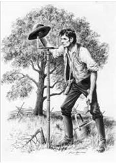
1 Basis of Bearings Scott Reeser, P.L.S. NYSAPLS 2018 Conference INTRODUCTION: Over 25 years experience in the surveying profession Graduate of Penn State survey program Licensed in Pennsylvania, New York, West Virginia and Colorado Been a member of home state s professional society for many years; presenter at several of Pennsylvania s annual conferences Just another surveyor trying to share information with others and gain knowledge from fellow professionals. WARNING: This presentation is not intended to be a class lecture. The intent is to present the attendees with information I have gathered thru various sources and stimulate discussion on these topics. Participation from the attendees is essential to the success of the session. Everyone in attendance is asked to provide input and ask questions. By gathering input from those present, we may all learn something by the end of the day. 1
2 THE ATTENDEES How many are licensed surveyors in New York or another state? Anyone a licensed professional, not a surveyor? Those that are not licensed as a surveyor, are you in pursuit of a license? THE ATTENDEES How long have you been involved in the surveying profession? How many have a college degree in surveying? Objectives of this Webinar: Define Basis of Bearing Clarify the difference between Grid North and True North Review the commonly used basis of bearings 2
3 Objectives of this Webinar: Discuss how each method is derived Identify common problems or mistakes found with each method Encourage discussion within the group to share knowledge and experience WHAT IS BASIS OF BEARING? Per Writing Legal Descriptions by Gurdon Wattles: A basis of bearings is a determination for the orientation of angular relationships of lines in a description or on a map. WHY DO WE CARE? Surveyors use Bearings and Distances every day It is a Geo referenced world Allows us to retrace the footsteps of others Could we do without? We are the professionals that should care 3
4 HOW DOES THE BASIS OF BEARING AFFECT THE WORK OF A SURVEYOR? Commonly Used Terms: Bearing Greenwich Hour Angle Declination Ephemeris Isogonic Map or Chart Commonly Used Terms: Latitude Longitude True North Magnetic North Grid North 4
5 Commonly used Basis of Bearing: Assumed Record Document Magnetic / Compass Stellar Observation GPS / GNSS Derived Methods for Basis of Bearing: Assumed: Random North Commonly used on small projects Quick and easy Can be changed later during the project Problem: no way to retrace the bearings as it was 100% random 5
6 Assumed: Concerns: o Non repeatable process o Cannot overlay survey on other data without rotation Benefits o Easy method o No calculations to determine north Reference to other Documents: Tie into parts of another document Actually is using another basis for bearing Sometimes, the basis for the record being relied upon is not clear or known Referral document may be unrecorded Reference to other Documents: Documents may include: o Previous deed of record o Adjoining parcel s deed of record o Subdivision Plans o Roadway Plans o Previous Survey (subject or adjoining) o Documents do not need to be recorded or public knowledge 6
7 Reference to other Documents: Concerns: o Basis of referenced document? o Non repeatable process without the previous document Benefits o Easy method o No calculations Magnetic / Compass: Relies upon a magnetic observation Magnetic North versus True North is a factor Requires compensation for Magnetic Declination Errors in the method can vary greatly dependent on the process used. Magnetic / Compass: Magnetic North is?? True North is?? What is the difference? How do we compensate for Magnetic Declination from one survey to the next? 7


8 Magnetic / Compass: Magnetic Declination can be: o Secular o Daily o Annual o Irregular Magnetic Declination in 1890: Magnetic Declination in 2010: 8

9 Magnetic Declination Online Tool: Magnetic Declination in 2016: Magnetic / Compass: Procedure requires observation between two (2) fixed points From the first point, the next point is sighted The direction is read from the compass face, this is bearing of the line 9


10 10

11 Magnetic / Compass: Conversion from True North to Magnetic North is simple math You need to know the declination at the time of the observation Declination to WEST = add declination value if bearing is NE or SW; subtract is NW or SE Declination to EAST; reverse the above 11
12 Magnetic / Compass Method Benefits: Straight forward procedure Equipment simple to use Minimal calculations Magnetic / Compass Method Concerns: Observations are subject to declination Quality of Compass Errors in compass operation / function / reading o Magnetic interference o Needle stick / bent needle o Angle reading o Parallax in glass o Instrument leveling Stellar Observation: Uses a survey instrument to observe the position of heavenly body at a given time as they relate to fixed points in the earth Typically uses the Sun or Polaris Requires detailed calculations Tried and tested method for determining where you are and which way is True North 12
13 Stellar Observation: Why the Sun or Polaris? o Easy to see o Known positions / track in sky Which is more accurate? Stellar Observation: Polaris position in the sky almost true north Best time to view Polaris is between lower culminations In the Northern Hemisphere, Polaris appears to move very slowly Locations close to Equator use caution using Polaris Use Hour Angle method for calculations 13


14 14
15 Stellar Observation Field Procedure: Place survey instrument on first known point Sight the second known point, set zero on horizontal scale Sight the star with the instrument placing the crosshairs just ahead of the star in its projected path Stellar Observation Field Procedure: Note the time at which the star crosses the vertical crosshair, as well as the horizontal angle Repeat this process in both direct and reverse Observation of the Sun requires special precautions Expected locations of the star to be sighted are typically computed ahead Stellar Observation Computations: The time of each observation must be reduced to Local Civic Time A value for GHA must be interpolated from ephemeris data Mathematical calculations are now performed to determine the bearing 15

16 16
17 Stellar Observation Concerns: Unfamiliar process Precise timekeeping is needed Clear sky is needed Possible need for specialized equipment Accuracy of instrument Mathematical calculations Stellar Observation Benefits: Tried and tested process No electronics are needed Reliable method Stellar Observation Reinforcement of the Principles: US Naval Academy suspended teaching Celestial Navigation in the 90 s In November of 2015, the Naval Academy announced they were bringing the training back Why the change of attitude? 17
18 Stellar Observation Reinforcement of the Principles: Knowledge of celestial navigation in the GPS era provides a solid back up from navigation in the event GPS becomes unreliable for whatever reason. Captain Timothy Tisch, instructor US Merchant Marine Academy. It is also good professional practice to use one navigational system to verify the accuracy of another. GPS / GNSS Derived: The equipment tells us which was is Grid North Based on a pre programmed coordinate system / datum In reality it is a advanced stellar observation o The receiver uses signals from the satellites to determine a position on the earth o The satellite s position is known and part of the internal calculations 18
 no extra steps Practical Application: Practical Applications / Discussions: If no basis of bearing is noted in a")
19 GPS / GNSS Derived Concerns: Concerns o Relies on the use of GPS/GNSS equipment o Relies on proper entry of coordinate system o Surveyor must assume calculations are correct Benefits o Quick and easy process o Bearing base determination is seamless with other work (RTK or Static) no extra steps Practical Application: Practical Applications / Discussions: If no basis of bearing is noted in a survey (plan or legal description) what do you assume? Prior to 1850, assumption is magnetic bearing base From 1850 to 1950 official surveys required reference to true meridian This requirement was removed in 1950, assumption is back to magnetic 19
20 Practical Applications / Discussions: If no basis of bearing is noted in a survey (plan or legal description) what do you assume? Practical Applications / Discussions: Curtis Brown s 24 th Principle The basis of bearings should be indicated and should not be left to speculation or assumption on the part of the surveyor or the courts. More specifically: (c) Where no basis of bearing is given or implied by a call for a map, true or magnetic bearings are to be used, depending on the presumption in the particular state. Practical Applications / Discussions: How should we document Basis of Bearing? Survey plans o Sipe s method o Audience ideas Legal Descriptions Report of Survey 20
21 Recap: Understanding the Basis of Bearing is important when conducting a retracement survey. Providing some reference to the basis of bearing used in the survey in our record documents is key for those that follow us. Surveyors are the professionals that should be experts in Basis of Bearing and therefore have a duty to help others understand what it really means. References & Credits: I cannot take credit for the technical information in this presentation, it is a collection or research I have collected from a host of sources that include: The Advantages of Polaris Observations in Land Surveying Robert Fink & Jerry Wahl Boundary Retracement Principles and Procedures for Pennsylvania, 4th Edition Knud Everett Hermansen Brown s Boundary Control and Legal Principles, 6 th Edition Walter Robilard, Donald Wilson & Curtis Brown Compass Land Surveying Henry Seip Definitions of Surveying and Associated Terms, ACSM References & Credits: Contd Elementary Surveying Breed & Housner Elementary Surveying, 8 th Edition Wolf & Ghilani Land Survey Descriptions Gurdon Wattles Manual of Surveying Instruction Bureau of Land Management The Surveying Handbook Russell Brinker & Roy Minnick website 21

22 References & Credits: Contd Teaching and interactions from various surveyors I have worked with including: Gregory Kohl, P.L.S. Gary Cuppels, P.L.S. Robert Miller, P.L.S. Mathew Boozer, S.I.T. And others. 22
PY 124: Terrestrial Position from Celestial Observations
 The linked image cannot be displayed. The file may have been moved, renamed, or deleted. Verify that the link points to the correct file and location. The linked image cannot be displayed. The file may
CHAPTER 2 SKILL SHEET 2: CELESTIAL NAVIGATION
 CHAPTER 2 SKILL SHEET 2: CELESTIAL NAVIGATION Before the invention of GPS technology, how were people on ships far at sea, out of the sight of land, able to tell where they were? For thousands of years
Land Navigation Table of Contents
 Land Navigation Table of Contents Preparatory Notes to Instructor... 1 Session Notes... 5 Learning Activity: Grid Reference Four Figure... 7 Learning Activity: Grid Reference Six Figure... 8 Learning Activity:
Solar Observations Using Total Stations Phenomenal Results by: Sayed R. Hashimi, Professor Surveying Engineering Department Ferris State University
 Phenomenal Results by: Sayed R. Hashimi, Professor Surveying Engineering Department Ferris State University Abstract Today s electronic total stations have all the features that make them the most desirable
GPS Measurement Protocol
 GPS Measurement Protocol Purpose To determine the latitude, longitude, and elevation of your school and of all your GLOBE sites Overview The GPS receiver will be used to determine the latitude, longitude
CHAPTER II THE COORDINATES SYSTEM AND FORMULARIES
 CHAPTER II THE COORDINATES SYSTEM AND FORMULARIES www.loxodrome.org/ Introduction to Celestial Navigation/Chapter II THE CO-ORDINATES SYSTEMS AND FORMULARIES In previous section we had a purely geometrical
CHAPTER 20 SIGHT REDUCTION
 CHAPTER 20 SIGHT REDUCTION BASIC PRINCIPLES 2000. Introduction Reducing a celestial sight to obtain a line of position consists of six steps: 1. Correcting sextant altitude (hs) to obtain observed altitude
This unit is primarily aimed at learners who intend to seek employment within the maritime industry.
 General information for centres Unit title: Celestial Navigation (SCQF level 8) Unit code: HW6M 48 Superclass: RE Publication date: November 2017 Source: Scottish Qualifications Authority Version: 01 Unit
Elementary. Angles and directions
 Elementary Surveying Angles and directions Prepared by: Andre Paul C. Ampong 3 Vertical angles Vertical angles are referenced to: The horizon by plus or minus The zenith The nadir Zenith and nadir are
Transforming from Geographic to Celestial Coordinates
 Transforming from Geographic to Celestial Coordinates Michael McEllin 1 Introduction The simplest astronomical observation of all is that the stars appear to move around the Earth (which, of course is
Chapter S1 Lecture. The Cosmic Perspective Seventh Edition. Celestial Timekeeping and Navigation Pearson Education, Inc.
 Chapter S1 Lecture The Cosmic Perspective Seventh Edition Celestial Timekeeping and Navigation 2014 Pearson Education, Inc. Celestial Timekeeping and Navigation 2014 Pearson Education, Inc. S1.1 Astronomical
NAVIGATION THEORY QUESTIONS Basics of Navigation
 NAVIGATION THEORY QUESTIONS Basics of Navigation Q610065 look at it The angle between the plane of the ecliptic and the plane of equator is approx? 23.5 degrees In which two months of the year is the difference
Section 2. Locating Astronomical Objects in the Night Sky What Do You See? What Do You See? Think About It. Investigate.
 Section 2 Locating Astronomical Objects in the Night Sky Section 2 Locating Astronomical Objects in the Night Sky What Do You See? What Do You See? Learning Outcomes In this section, you will Construct
Geographers Tools: Location Systems Prof. Anthony Grande Hunter College Geography
 5 Geographers Tools: Location Systems Prof. Anthony Grande Hunter College Geography Lecture design, content and presentation AFG 0119 Individual images and illustrations may be subject to prior copyright.
Lab Title: Parallax and Astronomical Distances. Equipment: Sextant Meter sticks (or tape measures) Calipers Magnetic compasses.
 Calipers Magnetic compasses.") Lab Title: Parallax and Astronomical Distances Equipment: Sextant Meter sticks (or tape measures) Calipers Magnetic compasses Introduction: Since we cannot travel to most celestial objects in order to
Lab Title: Parallax and Astronomical Distances Equipment: Sextant Meter sticks (or tape measures) Calipers Magnetic compasses Introduction: Since we cannot travel to most celestial objects in order to
OCN 201 LAB FALL 2003 POLYNESIAN AND WESTERN NAVIGATION
 Name: OCN 201 LAB FALL 2003 POLYNESIAN AND WESTERN NAVIGATION INTRODUCTION People have been sailing the seas for thousands of years, during most of which time they relied on the sun and the stars to navigate
Navigation. Longitude and Latitude Foundations of Navigation. MTPs:
 Navigation 3.01 Foundations of Navigation References: FTGU pages 177-178, 184-190 Transport Canada Study and Reference Guide Glider Pilot Canada Flight Training Manual Pilot Navigation http://en.wikipedia.org/wiki/transverse_mercator_projection#spherical_transverse_mercator
COORDINATE SYSTEMS: LOCATING YOURSELF ON A SPHERE
 NAME DATE PARTNER(S) COORDINATE SYSTEMS: LOCATING YOURSELF ON A SPHERE Activity 1: Getting Your Bearings 1. Close your eyes and point to the north. Did you point up? Why or why not? Up is the #1 answer.
DUMMIES guide to Astro-Navigation
 DUMMIES guide to Astro-Navigation The idea of this booklet is to give you the nuts and bolts in the process of gaining a position on your chart through celestial navigation without a deep understanding
Using Map and Compass Together
 Using Map and Compass Together In situations where you foresee a potential evacuation on foot, where there are no roads, and no indication as to the direction of travel (i.e., road signs), it is recommended
Shape of the Earth. Data Output by the Receiver
 It is quite common for confusion to arise about the process used during a hydrographic survey when GPS-derived water surface elevation is incorporated into the data as an RTK Tide correction. This article
ASTRONOMICAL NAVIGATION
 Basic terms ASTRONOMICAL NAVIGATION *astronomical navigation *compilation *astronomical tabels *celestial observations *solution of a sight * Sun/Moon/star sight *spherical trigonometry *PZX triangle *celestial
Compass Basics. Quick Map Basics Review For Compass Use
 Compass Basics Quick Map Basics Review For Compass Use A topographic map tells you where things are and how to get to them, whether you're hiking, biking, hunting, fishing, or just interested in the world
Chapter 6: Latitude by Noon Sight
 Chapter 6: Latitude by oon ight When the sun is crossing the meridian of the boat, it is straight south or north of the boat and at its highest altitude over the horizon for the day. The local meridian
Astronomy 311 Professor Menningen January 2, Syllabus overview books & supplies course goals assignments & grading About the professor
 1 Astronomy 311 Professor Menningen January 2, 2014 Syllabus overview books & supplies course goals assignments & grading About the professor 2 How to Learn Astronomy Stay curious Interact with the same
HOW TO TRAVEL ON EARTH WITHOUT GETTING LOST
 HOW TO TRAVEL ON EARTH WITHOUT GETTING LOST Using a globe to learn how a position on Earth can be described. Rui Dilão, Instituto Superior Técnico Curriculum topic latitude, longitude, coordinate system
Meridian Circle through Zenith, North Celestial Pole, Zenith Direction Straight Up from Observer. South Celestial Pole
 Chapter 3 How Earth and Sky Work- Effects of Latitude In chapters 3 and 4we will learn why our view of the heavens depends on our position on the Earth, the time of day, and the day of the year. We will
The Earth is a Rotating Sphere
 The Earth is a Rotating Sphere The Shape of the Earth Earth s Rotation ( and relative movement of the Sun and Moon) The Geographic Grid Map Projections Global Time The Earth s Revolution around the Sun
National Maritime Center
 National Maritime Center Providing Credentials to Mariners Q127 Navigation Problems-Oceans (Sample Examination) Page 1 of 5 Choose the best answer to the following Multiple Choice questions. 1. You depart
Modern Navigation. Thomas Herring
 12.215 Modern Navigation Thomas Herring Review of Last Class Almanacs: Paper and electronics Paper Almanacs: Nautical Almanac Electronic: Available on many web sites Homework #1 solutions 10/17/2006 12.215
USING THE MILITARY LENSATIC COMPASS
 USING THE MILITARY LENSATIC COMPASS WARNING This presentation is intended as a quick summary, and not a comprehensive resource. If you want to learn Land Navigation in detail, either buy a book; or get
Understanding Positional Astronomy Part 2 Celestial Co-ordinates Difficulty: Intermediate
 Exercise: Understanding Positional Astronomy Part 2 Celestial Co-ordinates Difficulty: Intermediate Objectives In Part 1 you learned about Celestial Sphere and how the stars appear to move across the night
Patterns in the Sky & Constellations
 Patterns in the Sky & Constellations Daily Homework & Warm-Ups Before class (8am): answer warm-up questions online about reading for the day http://neutrino.otterbein.edu/~tagg/courses/too ls/warmupdb/astronomy_section_1
INTRODUCTION FOREWORD
 FOREWORD The Sight Reduction Tables for Air Navigation consist of three volumes of comprehensive tables of altitude and azimuth designed for the rapid reduction of astronomical sights in the air. This
Why does Earth rotate and what s the evidence? (besides watching it from space ships or satellites) Week 18 January 5, 2015
 Week 18 January 5, 2015") Why does Earth rotate and what s the evidence? (besides watching it from space ships or satellites) Week 18 January 5, 2015 The sun determines our solar time everywhere on earth as Earth rotates. Can you
Why does Earth rotate and what s the evidence? (besides watching it from space ships or satellites) Week 18 January 5, 2015 The sun determines our solar time everywhere on earth as Earth rotates. Can you
The. Astronomy is full of cycles. Like the day, the month, & the year In this section we will try to understand these cycles.
 Understanding The Sky Astronomy is full of cycles Like the day, the month, & the year In this section we will try to understand these cycles. For Example Why do we think of stars as nighttime objects?
Relative and Absolute Directions
 Relative and Absolute Directions Purpose Learning about latitude and longitude Developing math skills Overview Students begin by asking the simple question: Where Am I? Then they learn about the magnetic
Chapter 3 Models of the Earth. 3.1 Finding Locations on the Earth. 3.1 Objectives
 Chapter 3 Models of the Earth 3.1 Finding Locations on the Earth 3.1 Objectives Explain latitude and longitude. How can latitude and longitude be used to find locations on Earth? How can a magnetic compass
Gnomon (a thin, round stick at least a foot long and capable of being put into the ground or stood up vertically)
") Name: Partner(s): Lab #3 Celestial Navigation Due 7/2 Objectives In this lab you will take measurements of the sun s motion around noon and the north star s position in the sky. You will use this data
Name: Partner(s): Lab #3 Celestial Navigation Due 7/2 Objectives In this lab you will take measurements of the sun s motion around noon and the north star s position in the sky. You will use this data
Red Star Navigation. Bearings:
 Red Star Navigation Bearings: The main focus in Red Star Navigation is how to use a compass and in particular compass bearings. It is important for cadets to describe bearings as this will assist them
Background Information
 Oceanography LAB #1: Marine Charts and Navigation Background Information Latitude and Longitude A coordinate is an address a means of designating location. Most coordinate systems involve a network of
National Maritime Center
 National Maritime Center Providing Credentials to Mariners Q207 Navigation Problems-Oceans (Sample Examination) Page 1 of 6 Choose the best answer to the following Multiple Choice questions. 1. On 1 December
Guidance to Instructors on Subject Delivery MAP READING. This is a suggested programme for the delivery of this subject.
 Programme of learning: Guidance to Instructors on Subject Delivery This is a suggested programme for the delivery of this subject. The main headings are the Learning Outcomes (LO1, LO2, etc), with sub
EN5302. US ARMY ENGINEER SCHOOL CARTOGRAPHY II Grid Construction, Plotting and Projection Graticules
 SUBCOURSE EN5302 EDITION 6 US ARMY ENGINEER SCHOOL CARTOGRAPHY II Grid Construction, Plotting and Projection Graticules TABLE OF CONTENTS PAGE INTRODUCTION... iii GRADING AND CERTIFICATION INSTRUCTIONS...
Mapping Earth s Surface Chapter 2 Section 3
 Mapping Earth s Surface Chapter 2 Section 3 Day 1 Objective I will understand maps can be used to find locations on Earth and to represent information about features on Earth s Surface I will understand
Office 307 Breshnahan Hall Phone: ext MT3121 CELESTIAL NAVIGATION II
 MT3121 CELESTIAL NAVIGATION II Learning Objective Celestial Navigation II will cover the requirements of the 1978 STCW convention as amended in 1995. The course covers the theory and practice of navigation
SMILE Teacher Workshop 2007 Winter Teachers Workshop Maritime Science. Maritime Science
 This activity is adapted from Teach Engineering lessons and activities How to be a great navigator, The North (Wall) Star, and Vector Voyage! http://www.teachengineering.org/index.php Integrated Teaching
ROYAL CANADIAN AIR CADETS PROFICIENCY LEVEL FOUR INSTRUCTIONAL GUIDE SECTION 1 EO M DEFINE AIR NAVIGATION TERMS PREPARATION
 ROYAL CANADIAN AIR CADETS PROFICIENCY LEVEL FOUR INSTRUCTIONAL GUIDE SECTION 1 EO M437.01 DEFINE AIR NAVIGATION TERMS Total Time: 60 min PREPARATION PRE-LESSON INSTRUCTIONS Resources needed for the delivery
Activities: Map and Compass
 Activities: Map and Compass Determining General Directions Modified with permission from Outdoor Living Skills Series: Map and Compass, Missouri Department of Conservation Overview: Students use the sun
Where in the World? Plotting Latitude & Longitude
 Where in the World? Plotting Latitude & Longitude Background Because our planet is a sphere, we need two types of reference lines to locate positions on the Earth and to make accurate maps. These imaginary
How to Use a Compass with a USGS Topographic Map
 How to Use a Compass with a USGS Topographic Map METHOD #1: (these directions assume your orienting arrow lines up with the North indicator on your compass dial, meaning the compass has not been adjusted
LONGITUDE AND LATITUDE. Semi great circles joining the true or geographic poles of the earth (true meridians).
.") MERIDIANS OF LONGITUDE LONGITUDE AND LATITUDE Semi great circles joining the true or geographic poles of the earth (true meridians). They are measured from 0 to 180 degrees East and West of the PRIME MERIDIAN,
MERIDIANS OF LONGITUDE LONGITUDE AND LATITUDE Semi great circles joining the true or geographic poles of the earth (true meridians). They are measured from 0 to 180 degrees East and West of the PRIME MERIDIAN,
Guide to Polar Alignment of a Meade LX200GPS Telescope
 Guide to Polar Alignment of a Meade By Dale A. Chamberlain dale@dchamberlain.net April 18, 2006 Page 1 of 11 1 Why Polar Align? After making an investment in a telescope such as the Meade LX200GPS, you
Charts and Chart Work with Poole Sailing
 with Poole Sailing Nautical charts are a mine of information but they need to be up to date. Corrections to charts are published by the Hydrographic Office monthly as Notices to Mariners both in print
By Jeffery Patterson and Brandy J. Merwin
 By Jeffery Patterson and Brandy J. Merwin 22 L T h e S c i e n c e Te a c h e r earning cycle investigations allow science students to model the activities of real scientists. An important step in modeling
Astronomy 101: 9/18/2008
 Astronomy 101: 9/18/2008 Announcements Pick up a golf ball at the front of the class or get one from Alex; you will need it for an in-class activity today. You will also need the question sheet from Alex.
Chapter S1 Celestial Timekeeping and Navigation. How do we define the day, month, year, and planetary time periods?
 Chapter S1 Celestial Timekeeping and Navigation S1.1 Astronomical Time Periods Our goals for learning:! How do we define the day, month, year, and planetary time periods?! How do we tell the time of day?!
ch02.pdf chap2.pdf chap02.pdf
 Introduction to Geographic Information Systems 8th Edition Karl Solutions Manual Full Download: http://testbanklive.com/download/introduction-to-geographic-information-systems-8th-edition-karl-solutions-manu
BUSH NAV BUSH NAV DAY Navigation for Bush Navigation Day. November. WhitehorseD AY. Section 1 Registration, Maps & Checkpoints
 BUSH DAY Navigation for Bush Navigation Day Robert Kirwan, Nunawading SES W NW N NE E If you have little or no bush navigation experience then you will have been teamed up with members that have that experience
Mounts and Coordinate Systems
 Mounts and Coordinate Systems Part 3: Some Advanced Techniques For Mounts Last month we looked at the basic mount types and methods for aligning them. This month s article, and the last for this series
LOCATING CELESTIAL OBJECTS: COORDINATES AND TIME. a. understand the basic concepts needed for any astronomical coordinate system.
 UNIT 2 UNIT 2 LOCATING CELESTIAL OBJECTS: COORDINATES AND TIME Goals After mastery of this unit, you should: a. understand the basic concepts needed for any astronomical coordinate system. b. understand
CHAPTER 19 SIGHT REDUCTION
 CHAPTER 19 SIGHT REDUCTION BASIC PROCEDURES 1900. Computer Sight Reduction The purely mathematical process of sight reduction is an ideal candidate for computerization, and a number of different hand-held
1.4j interpret simple shadow stick data to determine local noon and observer s longitude
 1.4j interpret simple shadow stick data to determine local noon and observer s longitude There are many opportunities for making observations of shadows cast with a vertical stick and the Sun. Observations
What is a map? A Map is a two or three-dimensional model or representation of the Earth s surface. 2-Dimensional map
 What is a map? A Map is a two or three-dimensional model or representation of the Earth s surface. 2-Dimensional map What is a Map Projection? Planar Projection Projection A Projection is a mathematical
Topic Guide: The Celestial Sphere. GCSE (9-1) Astronomy. Pearson Edexcel Level 1/Level 2 GCSE (9-1) in Astronomy (1AS0)
 Astronomy. Pearson Edexcel Level 1/Level 2 GCSE (9-1) in Astronomy (1AS0)") Topic Guide: The Celestial Sphere GCSE (9-1) Astronomy Pearson Edexcel Level 1/Level 2 GCSE (9-1) in Astronomy (1AS0) The Celestial Sphere Contents Specification Points 1 The Astronomy 2 Equatorial coordinates
Topic Guide: The Celestial Sphere GCSE (9-1) Astronomy Pearson Edexcel Level 1/Level 2 GCSE (9-1) in Astronomy (1AS0) The Celestial Sphere Contents Specification Points 1 The Astronomy 2 Equatorial coordinates
The Sky. Day sky: the Sun, occasionally the Moon. Night Sky: stars, and sometimes the Moon
 The Sky Day sky: the Sun, occasionally the Moon Night Sky: stars, and sometimes the Moon So MANY objects.how Do We Make Sense of it ALL?? Goal How to describe the locations of objects in the sky To understand
Day, Night & the Seasons. Lecture 2 1/15/2013
 Day, Night & the Seasons Lecture 2 1/15/2013 Logistics The following students see me after class: Dahms, Doyle, Kavalle, Jennings, Melton, Polsky, Soriano, Augustinovich, Briggs Anyone who was not here
Answers to Lyra Celestial Navigation Refresher Exercise
 Answers to Lyra Celestial Navigation Refresher Exercise Correcting Your Sight Reduction Forms Below are the sight reduction forms and plotting sheets for the navigation exercise. The sight reduction forms
GERMAN TYPE EQUATORIAL MOUNT (FM 51/52 - FM 100/102 - FM150) USER MANUAL
 USER MANUAL") GERMAN TYPE EQUATORIAL MOUNT (FM 51/52 - FM 100/102 - FM150) USER MANUAL NOMENCLATURE MANUAL KNOB WORM DRIVE TIGHTENING SCREW FIXING CLUTCH CONTROL PLUG POLAR SCOPE PEEP HOLE PLATFORM ALTITUDE MOUNTING
GERMAN TYPE EQUATORIAL MOUNT (FM 51/52 - FM 100/102 - FM150) USER MANUAL NOMENCLATURE MANUAL KNOB WORM DRIVE TIGHTENING SCREW FIXING CLUTCH CONTROL PLUG POLAR SCOPE PEEP HOLE PLATFORM ALTITUDE MOUNTING
Module 2: Mapping Topic 2 Content: Determining Latitude and Longitude Notes
 Introduction In order to more easily locate points on a globe or map, cartographers designed a system of imaginary vertical lines (also called parallels) and horizontal lines (also called meridians) that
Surveying Prof. Bharat Lohani Department of Civil Engineering Indian Institute of Technology, Kanpur. Module - 4 Lecture - 1 Compass Surveying
 Surveying Prof. Bharat Lohani Department of Civil Engineering Indian Institute of Technology, Kanpur Module - 4 Lecture - 1 Compass Surveying Welcome to this video lecture series on basic surveying and
Angles and Directions. Angles and Directions. CIVL 1112 Surveying - Azimuths and Bearings 1/8
 IVL 1112 Surveying - zimuths and earings 1/8 The most common relative directions are left, right, forward(s), backward(s), up, and down. x y z In planar geometry, an angle is the figure formed by two rays,
II. COMPASS SURVEYING AND PLANE TABLE SURVEYING :
 1 II. COMPASS SURVEYING AND PLANE TABLE SURVEYING : Prismatic compass surveyor s compass bearing system of conversions Local attraction magnetic declination Dip Traversing Plotting Adjustment of errors
Latitude and Longitude:
 Latitude and Longitude: Finding Locations on Planet Earth. With thanks and credit to Step.com Typical Graph This is an example of a typical graph. It is made up of points that are connected by a line.
DRAFT MARINE ARTILLERY SURVEY
 MARINE ARTILLERY SURVEY Table of Contents Chapter 1: Mission, Organization, and Duties Section I: Mission PARA TITLE PAGE 1-1 Common Grid 1-1 1-2 Components of a Common Grid 1-1 1-3 Fundamentals of Survey
Engineering Surveying -1 CE212 Compass Surveying
 Engineering Surveying -1 CE212 Compass Surveying Lecture 2016, September 03-04 Muhammad Noman Compass Surveying Chain surveying can be used when the area to be surveyed is comparatively is small and is
Chapter -6- Angles, Bearings and Azimuths. Ishik University Sulaimani Civil Engineering Department Surveying II CE Introduction 1/28/2018
 Ishik University Sulaimani Civil Engineering Department Surveying II CE 215 Chapter -6- Angles, Bearings and Azimuths 1/28/2018 Assistant Lecturer / Asmaa Abdulmajeed 1 1. Introduction Measurement of angles
Cartesian Coordinates Need two dimensional system 2 number lines perpendicular to each other X-axis is horizontal Y-axis is vertical Position relative
 General Physical Science Chapter 15 Place and Time Space and Time Einstein Space and time related Single entity Time is the 4 th dimension! Cartesian Coordinates Need some system to tell us where something
Workforms. contents. Note on copyright and reproduction
 Workforms contents Form 104 for Sight Reduction with Pub. 249 or 229 Form 106 for Sight Reduction with NAO Tables Form 107 for LAN Sights Form 108 Combined Sight Reduction Form 109 for Solar Index Correction
Astronomy 115: Stars, Galaxies & Cosmos
 Astronomy 115: Stars, Galaxies & Cosmos Instructor Dr. Hillary Stephens Phone (253) 964-6540 office Office RAI 471* E-mail hstephens@pierce.ctc.edu Meeting Times M-Th: 11 12:15 pm in RAI 35 Office Hours
Day, Night & the Seasons. Lecture 2 1/21/2014
 Day, Night & the Seasons Lecture 2 1/21/2014 Logistics The following students see me after class: A. Gonzalez, Chen Anyone who was not here on first day see me after class Pin Numbers - if you have not
Lab Topographic Maps. Name: Partner: Purpose. Background Information
 Lab Topographic Maps Name: Partner: Purpose The purpose of this lab is to familiarize you with graphic representations of the Earth s surface primarily maps. Simple line maps show the spatial relationship
AST 2002 Introduction to Astronomy
 AST 2002 Introduction to Astronomy Recommended Textbooks The Cosmic Perspective The Essential Cosmic Perspective The Cosmic Perspective Fundamentals 8th Edition (Publisher: Pearson) Authors: Bennett, Donohue,
Lesson 3: Locating Plots on the Ground
 Review and Introduction Lesson 3: Locating Plots on the Ground So far, you have identified individual stands in the forest, learned about plot sampling, and marked locations on a map of where your inventory
Appearance of the Sky Orientation Motion of sky Seasons Precession (?)
") Today Appearance of the Sky Orientation Motion of sky Seasons Precession (?) The Celestial Sphere Stars at different distances all appear to lie on the celestial sphere. The ecliptic is the Sun s apparent
Today Appearance of the Sky Orientation Motion of sky Seasons Precession (?) The Celestial Sphere Stars at different distances all appear to lie on the celestial sphere. The ecliptic is the Sun s apparent
Introduction to Geographic Information Science. Updates/News. Last Lecture. Geography 4103 / Map Projections and Coordinate Systems
 Geography 4103 / 5103 Introduction to Geographic Information Science Map Projections and Coordinate Systems Updates/News Thursday s lecture Reading discussion 1 find the readings online open questions,
Reading Reminders. Your Questions via JiTT2
 ASTR1010 Lecture 5 29 Jan 13 Today How the Sky Works: Stars, Seasons, Phases Announcements: Old-Fashioned Homework 1 released tonight on D2L, due ON PAPER next Tuesday at the start of class If you brought
Polar Alignment of LX200R and Ultra Wedge For The Southern Hemisphere by Chris James
 Return To How To Menu Polar Alignment of LX200R and Ultra Wedge For The Southern Hemisphere by Chris James Overview This document goes thru the process required to Polar Align the LX200R using a Ultra
compass 1 of 5 For the complete encyclopedic entry with media resources, visit:
 This website would like to remind you: Your browser (Apple Safari 4) is out of date. Update your browser for more security, comfort and the best experience on this site. Encyclopedic Entry compass For
AST-103L Spring 2001: Astronomical Motions I. The Night Sky
 Early Greek observers viewed the sky as a transparent sphere which surrounded the Earth. They divided the stars into six categories of brightness with the brightest stars called first magnitude, the next
2007 ~ 2008 AP CALCULUS AB SYLLABUS
 2007 ~ 2008 AP CALCULUS AB SYLLABUS Teacher: Mr. Leckie Room: 201 Course: AP Calculus AB Textbook: Calculus: Graphical, Numerical, Algebraic, 3 rd edition COURSE CONTENT: Calculus is the mathematics of
SUB-PROBLEM 2: HOW DO SUN AND EARTH MOVE FOR THE EXISTING CYCLES AND SYMMETRIES TO OCCUR? (The invention of a Sun/Earth model)
") SUB-PROBLEM 2: HOW DO SUN AND EARTH MOVE FOR THE EXISTING CYCLES AND SYMMETRIES TO OCCUR? (The invention of a Sun/Earth model) We have made several advancements in the problem of interest proposed at the
SUB-PROBLEM 2: HOW DO SUN AND EARTH MOVE FOR THE EXISTING CYCLES AND SYMMETRIES TO OCCUR? (The invention of a Sun/Earth model) We have made several advancements in the problem of interest proposed at the
Introduction To Modern Astronomy I: Solar System
 ASTR 111 003 Fall 2007 Lecture 02 Sep. 10, 2007 Introduction To Modern Astronomy I: Solar System Introducing Astronomy (chap. 1-6) Planets and Moons (chap. 7-15) Chap. 16: Our Sun Chap. 28: Search for
Rising, Setting and Twilight
 Rising, Setting and Twilight The rotation of e ear on its own axis causes e phenoenon of e rising and setting of all celestial bodies. Generally, e celestial bodies see to appear at e eastern horizon,
Tonight. {01} The map. Relative space. What does a map do? Types of maps GEOG 201 2/17/2010. Instructor: Pesses 1
 Tonight {01} The map What makes a map Measuring the Earth Map Interpretation & GPS Spring 2010 M. Pesses What does a map do? Shows where things are Shows spatial (topological) relationships Shows patterns,
Using Your Astrolabe
 Using Your Astrolabe So, you are working on your Astronomy Before the Telescope certification with the Astronomical League. You have built your Astrolabe. Now what? It seems easy enough to use a rotating
National Maritime Center
 National Maritime Center Providing Credentials to Mariners (Sample Examination) Page 1 of 5 Choose the best answer to the following Multiple Choice questions. 1. On 15 October your 0300 zone time DR position
Modern Navigation. Thomas Herring
 12.215 Modern Navigation Thomas Herring Review of last Class Motion of the Earth and Sun Geometry of Earth/Sun system Astronomical coordinates Motion of the Earth around the sun Equation of Time Astronomical
What is the Right Answer?
 What is the Right Answer??! Purpose To introduce students to the concept that sometimes there is no one right answer to a question or measurement Overview Students learn to be careful when searching for
The sunset project A database project on the observation of sunsets Caution
 A database project on the observation of sunsets Caution Never direct look into the sun. Always use protection glasses. Ask the teacher in case of doubt. Background information A sunset does not happen