Erich Gundlach, Ph.D.
|
|
|
- Jeffry Barrett
- 5 years ago
- Views:
Transcription

1 Oil Shoreline Interactions: Deepwater Horizon SETAC Boston, November 2011 Erich Gundlach, Ph.D. E-Tech International Inc. New York, USA cs.com
2 What s Going On Shorelines Sandy Beaches and Marshes Louisiana Sand Berm Project Oil-spill-info.com 2
 SCAT Teams: 6= FL, AL, MS 1 = Snorkel SCAT (East) 6 = LA USCG,")
 Source: JIC, Michel, NOAA as of 5 Nov 2011")
3 Current Status: Nov 2011 Not Over Working on the Response 1,786 people 328: equipment (17 Aug) SCAT Teams: 6= FL, AL, MS 1 = Snorkel SCAT (East) 6 = LA USCG, 2010 Shoreline: Stage 3: 5 miles (Being worked Daily) Stage 4: 290 miles (Monitoring and Cleaning if oil found) Source: JIC, Michel, NOAA as of 5 Nov 2011 Oil-spill-info.com 3

4 Oil-spill-info.com 4 Total Ever Oiled: 1,089 miles (5 Nov 11)

5 Shoreline Oiling Compared to Exxon Valdez Oil-spill-info.com 5
6 Heavy Category Exxon Valdez Exxon Valdez. 9 Apr 1989 Oil-spill-info.com 6

7 Heavy Category: Alvenus (Texas, 1984) Alvenus. August 1984 Oil-spill-info.com 7


8 Heavy Category: Ixtoc I Ixtoc I 20 Aug 1979 Oil-spill-info.com 8

9 9 Deepwater Horizon - Comparison

10 10 Deepwater Horizon - Comparison


11 Moderate and Heavy Categories DWH HEAVY - >3 feet wide and >50% distribution MODERATE - >6 feet wide and <50% distribution Oil-spill-info.com 11 SCAT Oiling Categories MC-252


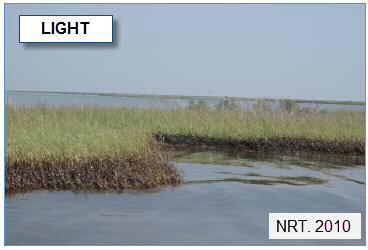
12 East of Mobile Bay Active Oiling (to ~July 2010) Oil Mats Bon Secour NWR Orange Beach, AL Eastern Perdido Key 29 June 2010 From: Parham, 2011 Oil-spill-info.com June 2010 Deepwater Horizon


13 Migrating berms, deep burial (~June-July July 2010). Beachface Overwash Berm Backshore Dunes Depth of Burial Decreases Overwash into supratidal 27 June 2010 Horn Is., MS Burial averages 20 to 50 cm beneath berm crest Oil-spill-info.com 13 8 Sep Gulf Shores, AL From: Parham, 2011


14 Wind exposed heavier oil lag deposits (to ~Jan 2011). beachface berm backshore dunes scour around oil N 9 Oct Petit Bois Is. MS Fill From: Parham, 2011


15 Winter (Jan-Mar 2011) - shoreline and oil erosion From: Parham, 2011


16 16 Seen before: Ixtoc I (Sep 1979)

17 Feb 2011: NEBA Analysis of Need for Cleanup Highly weathered: 86-98% Minimal risk to groundwater Below EPA risks to health Aquatic and wildlife will likely be more affected by cleanup than the oil 17


18 Throughout 2011: Work continues Public demand / perception dominate.

19 Oiling Status: Oct 2011 Oil-spill-info.com 19 NOAA Environmental Response Management Application (ERMA)

20 28-29 Oct 2011 (Eastern Area). NOAA Environmental Response Management Application (ERMA) Oil-spill-info.com 20


21 21 Marsh Oiling

22 Cleanup Keep Out of the Marsh Most oiling along marsh fringe. May September 2010: recovery adjacent to marsh. At end of re-oiling stage: Very Light Moderate Marshes = No additional treatment. Naturally cleaned by wave and tidal action Heavily Oiled (Barataria Bay): hard tarry debris mat (>10 cm) Zengel and Michel,

23 Oil Debris Removal Barataria Bay AFTER TESTING Raking and Cutting = Preferred Technique (initiated Feb 2011) Tested: flushing, surface washing agents, raking, cutting in various combinations. OnwingsofCare.org 6 May


24 24 An End in Sight?
25 Sand Berm Project To stop oil from hitting the interior marshes. 100 miles versus 3000 miles interior 11 May Permit Application by LA. Approved 2 weeks later Directed by FOSC that BP should pay for it. 320 ft wide at base x 6 ft high x 49 miles long. $360 million. 2 collections of tar balls recorded. Re-authorized by FOSC in September. From: On Scene Coordinators report,

26 The Louisiana Success Story This oil spill has devastated our coastal communities and our fragile ecosystem will pay a hefty price for this spill for years to come. Finally, a silver lining. The fortification of the oil barrier sand berms will result in the largest barrier islands restoration investment in Louisiana history. We re working to convert this into a $200 million effort to help restore the vital first line of defense. Chairman Garret Graves 26


27 27 Proven Success + NOAA Alternative

28 28 4 Berm Areas


29 29 17 June to 28 August 2010


30 30 13 Apr 2011


31 Blasted by the National Commission Generally not a viable spill response measure. Only 6% completed when well was capped. Trapped no more than 1,000 bbl total. Most expensive and controversial of all measures. 31
32 Update: 8 November 2011 "New holes have been breached, "If they continue (to break apart) at this rate, more than half has disappeared on two northern (berm) sites, another year could easily take the rest of it." N. Plant, USGS: Associated Press, 8 Nov 2011 Nathaniel Plant, an oceanographer with the U.S. Geological Survey, has been monitoring the berms built near the Chandeleur Islands and said they have been breaking apart after storms. "New holes have been breached," he said. "If they continue (to break apart) at this rate, more than half has disappeared on two northern (berm) sites, another year could easily take the rest of it." USGS is tracking what happens to the berms because it wants to see if the sand transported to Chandeleur Sound winds up accumulating on the barrier islands, which scientists fear will disappear as sea levels rise and hurricanes pummel them. "A research question is to what degree has putting that much sand out there turned the clock back (on island disintegration). We don't have a final answer on that at all," said Asbury Sallenger, a USGS oceanographer who heads up efforts to map changes along the Gulf Coast. 32
Extent and Degree of Shoreline Oiling: Deepwater Horizon (DWH) Oil Spill, Scott Zengel Research Planning, Inc. Tallahassee, Florida
 Oil Spill, Scott Zengel Research Planning, Inc. Tallahassee, Florida") Extent and Degree of Shoreline Oiling: Deepwater Horizon (DWH) Oil Spill, 2010 2013 Scott Zengel Research Planning, Inc. Tallahassee, Florida Background & Definitions SCAT survey data presented here SCAT
Extent and Degree of Shoreline Oiling: Deepwater Horizon (DWH) Oil Spill, 2010 2013 Scott Zengel Research Planning, Inc. Tallahassee, Florida Background & Definitions SCAT survey data presented here SCAT
Florida Panhandle and Alabama Beaches Welcome Spring Break: Free of Tar Balls at Last
 Florida Panhandle and Alabama Beaches Welcome Spring Break: Free of Tar Balls at Last Ping Wang, James H. Kirby III, and Jun Cheng Coastal Research Laboratory, Department of Geology, University of South
Sand and Oil Agglomerates in the Surf Zone Using Science to Aid Deepwater Horizon Clean-up Efforts
 Sand and Oil Agglomerates in the Surf Zone Using Science to Aid Deepwater Horizon Clean-up Efforts P. Soupy Dalyander St. Petersburg Coastal and Marine Science Center DOI USGS Sand and Oil Agglomerates
Impacts of Hurricane Rita on the Beaches of Western Louisiana
 Impacts of Hurricane Rita on the Beaches of Western Louisiana By Hilary F. Stockdon, Laura A. Fauver, Asbury H. Sallenger, Jr., and C. Wayne Wright Hurricane Rita made landfall as a category 3 storm in
MISSISSIPPI COASTAL IMPROVEMENTS
 MISSISSIPPI COASTAL IMPROVEMENTS PROGRAM (MsCIP) Comprehensive Barrier 237 27 200 237 27 200 Island 237 Restoration 27 200 Plan 80 9 27 252 74.59 255 255 255 0 0 0 63 63 63 3 32 22 239 65 53 0 35 20 2
Quantifying effects of oil on coastal dune vegetation. Thomas Miller and Elise Gornish Biological Science, Florida State University
 Quantifying effects of oil on coastal dune vegetation Thomas Miller and Elise Gornish Biological Science, Florida State University Natural History of Barrier Islands in the Northern Gulf Make up ~70% of
Hurricanes and Storm Surge : Before coming to lab, visit the following web site:
 Geol 108 Lab #7 Week of October 15-19, 2012 Coastal Studies Hurricanes and Storm Surge : Before coming to lab, visit the following web site: http://www.usatoday.com/graphics/weather/gra/gsurge/flash.htm
Changes in Ecosystems - Natural Events
 Changes in Ecosystems - Natural Events 8A predict and describe how different types of catastrophic events impact ecosystems such as floods, hurricanes, or tornadoes Textbook pages: 396-406 How can ecosystems
Phases of Disaster Response. John Yeaw, Gavin Vanstone, Haochen Wu, Jordan Tyler
 Phases of Disaster Response John Yeaw, Gavin Vanstone, Haochen Wu, Jordan Tyler BP Oil Spill One of the worst man made disasters in human history The BP oil spill occurred in April of 2010 when the Deepwater
Assessing fate and transport issues of the DWH oil spill using simulations and merged datasets
 Assessing fate and transport issues of the DWH oil spill using simulations and merged datasets Pat Fitzpatrick Geosystems Research Institute Mississippi State University The influence of cyclones on the
Whiskey Island Marsh Creation Rolling with the Punches
 Whiskey Island Marsh Creation Rolling with the Punches Santiago Alfageme, M&N Jerry Carroll, LADNR Brad Miller, LADNR Project Location Historic Island Retreat Previous Restoration Project Whiskey Island
Weathering, Erosion, and Deposition
 Weathering, Erosion, and Deposition E Q : H O W I S T H E E A R T H A F F E C T E D B Y C O N S T R U C T I V E A N D D E S T R U C T I V E F O R C E S? http://player.discoveryeducation.com/index.cfm?guidassetid=6b1e329e-5a77-4b36-bfa9-1d307f75441c&blnfromsearch=1&productcode=us
Hurricane Season 2010 & NOAA s Deepwater Response
 Hurricane Season 2010 & NOAA s Deepwater Response What s Happened? What Will 2010 Bring? Possible Shoreline Effects Darin Figurskey Meteorologist-in-Charge NOAA s NWS Raleigh, NC NOAA s National Weather
Geol 117 Lecture 18 Beaches & Coastlines. I. Types of Coastlines A. Definition:
 I. Types of Coastlines A. Definition: 1. Shore = narrow zone where ocean meets land (e.g. beach) 2. Coast is a broad area where both ocean and land processes act a. Includes onshore marshes, dunes, sea
Daily Operations Briefing December 25, 2012 As of 6:30 a.m. EST
 Daily Operations Briefing December 25, 2012 As of 6:30 a.m. EST 1 Significant Activity: Dec 24-25 Significant Events: Possible Severe thunderstorms - Gulf Coast Sandy/Nor easter recovery Significant Weather:
Stream Discharge and the Water Budget
 Regents Earth Science Unit 6: Water Cycle & Climate Name: Lab # Stream Discharge and the Water Budget Introduction: The United States Geological Survey (USGS) measures and publishes values for the daily
Environmental Sensitivity to Oil Spills in Gulf Shores, AL
 1 Environmental Sensitivity to Oil Spills in Gulf Shores, AL Prepared by: Matthew Dobbertien 2 December 2011 CE 394K: GIS in Water Resources Dr. David Maidment University of Texas at Austin 1 2 Content
Mapping, monitoring, and modeling: USGS Coastal and Marine Geology activities along the Northeast coast
 Mapping, monitoring, and modeling: USGS Coastal and Marine Geology activities along the Northeast coast Coastal and Marine Geology Program Woods Hole Coastal and Marine Science Center St. Petersburg Coastal
UNDERSTANDING COASTAL GEOLOGIC HAZARDS, SEA LEVEL RISE and CLIMATE CHANGE in THE NORTHEASTERN US
 UNDERSTANDING COASTAL GEOLOGIC HAZARDS, SEA LEVEL RISE and CLIMATE CHANGE in THE NORTHEASTERN US Congressional Hazards Caucus Briefing Washington, DC 18 November 2009 Jon C. Boothroyd Rhode Island Geological
UNDERSTANDING STORM TIDES
 UNDERSTANDING STORM TIDES Run from the water, hide from the wind.. CATEGORY CATEGORY CATEGORY CATEGORY CATEGORY 1 2 3 4 5 WIND 74-95 mph 64-82 knots 96-110 mph 83-95 knots 111-130 mph 96-113 knots 131-155
Shoreline Assessment Job Aid National Oceanic and Atmospheric Administration NOAA Ocean Service Office of Response and Restoration Hazardous
 Shoreline Assessment Job Aid National Oceanic and Atmospheric Administration NOAA Ocean Service Office of Response and Restoration Hazardous Materials Response Division This job aid was produced and published
WIND EFFECTS ON CHEMICAL SPILL IN ST ANDREW BAY SYSTEM
 WIND EFFECTS ON CHEMICAL SPILL IN ST ANDREW BAY SYSTEM PETER C. CHU, PATRICE PAULY Naval Postgraduate School, Monterey, CA93943 STEVEN D. HAEGER Naval Oceanographic Office, Stennis Space Center MATHEW
Monthly Long Range Weather Commentary Issued: SEPTEMBER 19, 2016 Steven A. Root, CCM, Chief Analytics Officer, Sr. VP,
 Monthly Long Range Weather Commentary Issued: SEPTEMBER 19, 2016 Steven A. Root, CCM, Chief Analytics Officer, Sr. VP, sroot@weatherbank.com SEPTEMBER 2016 Climate Highlights The Month in Review The contiguous
Natural Disasters. in Florida. Severe Thunderstorms
 Natural Disasters in Florida SC.6.E.7.7 Investigate how natural disasters have affected human life in Florida. Severe Thunderstorms While the typical afternoon thunderstorm in Florida may not appear to
Global Warming: Rising Sea Level
 Global Warming: Rising Sea Level Possible explanation for why human-induced global warming is still controversial 2007 - IPCC sea level rise estimate 1. Expansion due to warming of seawater... 28 cm 2.
Hurricane Tracking Lab
 Hurricane Tracking Lab Background: Hurricanes are one of nature s most powerful disasters. To equal the power of a hurricane, one would have to set off about a thousand nuclear devices per second for as
MODELLING CATASTROPHIC COASTAL FLOOD RISKS AROUND THE WORLD
 MODELLING CATASTROPHIC COASTAL FLOOD RISKS AROUND THE WORLD Nicola Howe Christopher Thomas Copyright 2016 Risk Management Solutions, Inc. All Rights Reserved. June 27, 2016 1 OUTLINE MOTIVATION What we
Extreme Changes to Barrier Islands Along the Central Gulf of Mexico Coast During Hurricane Katrina
 Extreme Changes to Barrier Islands Along the Central Gulf of Mexico Coast During Hurricane Katrina By Asbury Sallenger, Wayne Wright, Jeff Lillycrop, Peter Howd, Hilary Stockdon, Kristy Guy, and Karen
Controlling Processes That Change Land
 1 Name Date Controlling Processes That Change Land People try to control some of the processes that change land. To do this, people apply technology- the use of science to solve problems in everyday life.
Sea-level Rise on Cape Cod: How Vulnerable Are We? Rob Thieler U.S. Geological Survey Woods Hole, MA
 Sea-level Rise on Cape Cod: How Vulnerable Are We? Rob Thieler U.S. Geological Survey Woods Hole, MA Outline Sea-level and coastal processes Past sea-level change Predictions for the future Coastal responses
Analysis of Tides and Storm Surge from Observational Records in the Delaware Inland Bays
 Analysis of Tides and Storm Surge from Observational Records in the Delaware Inland Bays John Callahan Delaware Geological Survey Coastal GeoTools Conference March 30 April 2, 2015 Charleston, SC Outline
Weathering and Erosion
 Have you ever looked at the land around you and wondered how it was shaped? The geologic features that help define the world are still being shaped by the natural processes of weathering, erosion, and
Groundwater dynamics and surface water-groundwater interaction in a prograding delta island, Louisiana, USA
 Supplementary Information Groundwater dynamics and surface water-groundwater interaction in a prograding delta island, Louisiana, USA Michael T. O Connor 1* and Kevan B. Moffett 1,2 1 Department of Geological
SEGMENTED BREAKWATERS AND THEIR USE IN COASTAL LOUISIANA
 SEGMENTED BREAKWATERS AND THEIR USE IN COASTAL LOUISIANA Prepared by: Louisiana Coastal Protection and Restoration Authority Engineering Division March 2016 The geology of Louisiana s coastal zone is intimately
MEMORANDUM FOR SWG
 MEMORANDUM FOR SWG-2007-1623 Subject: Jurisdictional Determination (JD) for SWG-2007-1623 on Interdunal Wetlands Adjacent to Traditional Navigable Waters (TNWs) Summary The U.S. Environmental Protection
Impact & Recovery of Wetland Plant Communities after the Gulf Oil Spill in 2010 and Hurricane Isaac in 2012
 Impact & Recovery of Wetland Plant Communities after the Gulf Oil Spill in 2010 and Hurricane Isaac in 2012 Introduction: The coastal wetlands, estuaries and lagoon systems of the Gulf Coast are a hotspot
Three main areas of work:
 Task 2: Climate Information 1 Task 2: Climate Information Three main areas of work: Collect historical and projected weather and climate data Conduct storm surge and wave modeling, sea-level rise (SLR)
The Coast: Beaches and Shoreline Processes
 1 2 3 4 5 6 7 8 9 The Coast: es and Shoreline Processes Trujillo & Thurman, Chapter 10 Oceanography 101 Chapter Objectives Recognize the various landforms characteristic of beaches and coastal regions.
The Coast: Beaches and Shoreline Processes Trujillo & Thurman, Chapter 10
 The Coast: es and Shoreline Processes Trujillo & Thurman, Chapter 10 Oceanography 101 Chapter Objectives Recognize the various landforms characteristic of beaches and coastal regions. Identify seasonal
Changes to Land 5.7B. landforms: features on the surface of Earth such as mountains, hills, dunes, oceans and rivers
 All the landforms on Earth have changed over time and continue to change. Many of the changes were caused by wind, moving water, and moving ice. Mountains have grown and shrunk. Rivers have cut away land
Significant Coastal Storm Today through Thursday, 11/7-8. Weather Briefing
 Significant Coastal Storm Today through Thursday, 11/7-8 Weather Briefing Prepared 10:00 am EST Wednesday, November 7, 2012 Presented by Gary Conte, Warning Coordination Meteorologist NOAA s National Weather
Regional Sediment Management
 Regional Sediment Management Linda S. Lillycrop Program Manager Coastal Engineer US Army Engineer Research and Development Center Coastal and Hydraulics Laboratory Q AVG Coastal Resilience: The Environmental,
Think about the landforms where you live. How do you think they have changed over time? How do you think they will change in the future?
 reflect All the landforms on Earth have changed over time and continue to change. Many of the changes were caused by wind, moving water, and moving ice. Mountains have grown and shrunk. Rivers have cut
Short-Term Job Growth Impacts of Hurricane Harvey on the Gulf Coast and Texas
 Short-Term Job Growth Impacts of Hurricane Harvey on the Gulf Coast and Texas Keith Phillips & Christopher Slijk Federal Reserve Bank of Dallas San Antonio Branch The views expressed in this presentation
ACCELERATED BEACH EROSION ALONG THE UPPER TEXAS COAST
 ACCELERATED BEACH EROSION ALONG THE UPPER TEXAS COAST Young Hyun Park 1, Billy L. Edge 2 and Sehyun Cheon 3 The upper Texas coast has been severely eroded and beach erosion is going on. It is not extreme
Hurricane Katrina and Oil Spills: Impact on Coastal and Ocean Environments
 Archived version from NCDOCKS Institutional Repository http://libres.uncg.edu/ir/asu/ Pine, J. C. (June 2006). Hurricane Katrina and oil spills: Impact on coastal and ocean environments. Oceanography,
Changes in Texas Ecoregions Copy the questions and answers
 Changes in Texas Ecoregions Copy the questions and answers 1. What are some kinds of damage that hurricanes cause? Roads and bridges might be washed away. Trees and power lines can be knocked down. Area
Monthly Long Range Weather Commentary Issued: February 15, 2015 Steven A. Root, CCM, President/CEO
 Monthly Long Range Weather Commentary Issued: February 15, 2015 Steven A. Root, CCM, President/CEO sroot@weatherbank.com JANUARY 2015 Climate Highlights The Month in Review During January, the average
GNOME Oil Spill Modeling Lab
 GNOME Oil Spill Modeling Lab Name: Goal: After simulating an actual oil spill event, you will understand how oceanographers help to protect marine resources from pollution such as oil spills. You will
New NASA Ocean Observations and Coastal Applications
 New NASA Ocean Observations and Coastal Applications Duane Armstrong Chief, Applied Science & Technology Project Office August 20, 2014 1 Outline NASA s new Earth Science Ocean Science Missions for 2014
An overview of USGS Hurricane Sandy Supplemental Studies along the Delmarva Peninsula
 An overview of USGS Hurricane Sandy Supplemental Studies along the Delmarva Peninsula Neil K. Ganju, Laura L. Brothers, Nathaniel G. Plant, Christopher G. Smith, E. Robert Thieler Coastal and Marine Geology
Mapping Coastal Change Using LiDAR and Multispectral Imagery
 Mapping Coastal Change Using LiDAR and Multispectral Imagery Contributor: Patrick Collins, Technical Solutions Engineer Presented by TABLE OF CONTENTS Introduction... 1 Coastal Change... 1 Mapping Coastal
HURRICANE IRENE. CONFERENCE CALL BRIEFING SLIDES Saturday August 27, :30 AM
 HURRICANE IRENE CONFERENCE CALL BRIEFING SLIDES Saturday August 27, 2011 8:30 AM NHC TRACK AND CONE HURRICANE IRENE WATCHES/WARNINGS Hurricane Warning along south coast including all of Cape Cod and Islands
Supplemental Slides. Shore: Junction of Land & Water. Junction of Land & Water. Sea Level Variations. Shore vs. Coast. Sea Level Variations
 Shore: Junction of Land & Water Supplemental Slides Sediments come off land Most get dumped at the beach Sediment interacts with ocean waves and currents Junction of Land & Water Features: Breaking waves,
Shore: Junction of Land & Water. Sediments come off land Most get dumped at the beach Sediment interacts with ocean waves and currents
 Shore: Junction of Land & Water Supplemental Slides Sediments come off land Most get dumped at the beach Sediment interacts with ocean waves and currents Junction of Land & Water Features: Breaking waves,
Oyster Reef for Shoreline Stabilization and Restoration. Jason Kirkpatrick Conservation Program Manager MacDill AFB Tampa, Florida
 Oyster Reef for Shoreline Stabilization and Restoration Jason Kirkpatrick Conservation Program Manager MacDill AFB Tampa, Florida Interbay Penninsula Port of Tampa X The few remaining mangroves are being
2013 Tide Newsletter and occasionally by much more. What's more,
 The Official Newsletter for the Nor easters Metal Detecting Club! Tide s Ed it io n HTTP://WWW.NOR EASTER S.NET Year ly Ti des for 2013 The Metal Detecting Creed By Jessie Thompson We are Metal Detectorists.
Major Hurricane Earl
 Major Hurricane Earl Advisory 33 North Carolina Threat Assessment Prepared at: 11 AM Thursday September 2, 2010 Hurricane and Tropical Storm Warnings in effect for the North Carolina Coast and Sounds NWS
Extent and Degree of Shoreline Oiling: Deepwater Horizon Oil Spill, Gulf of Mexico, USA
 Extent and Degree of Shoreline Oiling: Deepwater Horizon Oil Spill, Gulf of Mexico, USA Jacqueline Michel 1,2 *, Edward H. Owens 3, Scott Zengel 1,4, Andrew Graham 5, Zachary Nixon 1,2, Teresa Allard 5,
March 11, 2011 Japanese Tsunami
 John Fassell March 11, 2011 Japanese Tsunami An earthquake occurred 30 miles under ground which lifted the seafloor Incoming wave as seen from shore Tsunami up to 130 feet tall in Miyako, JA that averaged
Developed in Consultation with Florida Educators
 Developed in Consultation with Florida Educators Table of Contents Next Generation Sunshine State Standards Correlation Chart... 7 Benchmarks Chapter 1 The Practice of Science...................... 11
Chapter 5: Weather Systems
 Chapter 5: Weather Systems Norwegian Cyclone Model: Polar Front Theory Mid Latitude Cyclones: extratropical cyclones, Nor easters Hurricanes Storm Surge Mid-latitude Cyclone: -primary weather producers
Major Hurricane Matthew Briefing Situation Overview
 Major Hurricane Matthew Briefing Situation Overview THIS IS NOW A WORST CASE STORM SURGE SCENARIO Catastrophic Damage is Anticipated for Coastal Areas. Major Hurricane Matthew is still expected to move
Primer on Coastal Erosion And Habitat Creation
 2 nd Regional Conference Dredging, Beach Nourishment & Bird Conservation Primer on Coastal Erosion And Habitat Creation Timothy Kana Ph.D Source: Newsday 1962 Photo by Kelsey Aerials 1978 Source: U Mass
DIVISION OF COASTAL MANAGEMENT TO STUDY CURRENT LONG-TERM EROSION RATES ADJACENT TO TERMINAL GROINS
 DIVISION OF COASTAL MANAGEMENT TO STUDY CURRENT LONG-TERM EROSION RATES ADJACENT TO TERMINAL GROINS North Carolina Department of Environmental Quality Division of Coastal Management February 22, 2018 N.
How does erosion happen?
 How does erosion happen? By National Geographic, adapted by Newsela staff on 10.03.17 Word Count 682 Level 830L These rock formations, in Bryce Canyon National Park, Utah, are called hoodoos. Although
1 MAR 110 Lecture #1 Introduction to Oceans Hazards SECTION I Volcano, Earthquake, and Tsunami Hazards
 1 MAR 110 Lecture #1 Introduction to Oceans Hazards SECTION I Volcano, Earthquake, and Tsunami Hazards Ocean Basin Rim Hazards - Earthquakes Earthquake-Induced Oil Storage Tank Conflagration Valdez, Alaska.(NG)
Lab 12 Coastal Geology
 Lab 12 Coastal Geology I. Fluvial Systems Hydrologic Cycle Runoff that flows into rivers = precipitation (rain and snowmelt) [infiltration (loss to groundwater) + evaporation (loss to atmosphere) + transpiration
Beach Recovery Processes in Urban Beach Systems : A Study in Hong Kong after an Extreme Storm Event
 Beach Recovery Processes in Urban Beach Systems : A Study in Hong Kong after an Extreme Storm Event LIFE+ FLANDRE international workshop "Management of coastal dunes and sandy beaches" Session 1. Climate
Welcome Jeff Orrock Warning Coordination Meteorologist National Weather Service Raleigh
 Welcome Jeff Orrock Warning Coordination Meteorologist National Weather Service Raleigh Jeff.orrock@noaa.gov Sources: Operational Significant Event Imagery and the Environmental Applications Team (EAT)
Hypoxia in the Northern Gulf of Mexico in 2010: was the Deepwater Horizon Oil Spill a Factor? Nathaniel E. Ostrom
 Agricultural Outlook Forum Presented: February 24-25, 2011 U.S. Department of Agriculture Hypoxia in the Northern Gulf of Mexico in 2010: was the Deepwater Horizon Oil Spill a Factor? Nathaniel E. Ostrom
Sediment Management in the Coastal Bays
 Sediment Management in the Coastal Bays Introduction Need for ecosystem view of sediment management in Coastal Bays Island loss and restoration Navigation needs Habitat Trade offs Living Shoreline Requirements
Tropical Storm Harvey: SE Texas Impacts
 Tropical Storm Harvey: SE Texas Impacts 10 AM CDT UPDATE Thursday, August 24, 2017 Prepared by: Dan Reilly, Brian Kyle PLEASE MUTE YOUR LINES AND DON T PUT ON HOLD! Situation Overview Tropical Storm Harvey
The Impact of Hurricane Irma on the Coast of Florida
 The Impact of Hurricane Irma on the Coast of Florida Ralph Clark, Guy Weeks, Robert Wang, Mike Manausa & Peter Bacopoulos Division of Water Resource Management February 8, 2018 Overview: Hurricane Irma
NOAA S Arctic Program in 2017
 NOAA S Arctic Program in 2017 NOAA s Arctic Mission To determine how the Arctic system is changing on time scales of weeks to decades, particularly with respect to the consequences that the loss of sea
Presentation Outline. Project Overview. Sea Level Rise Assessment & Decision Tools. Community Engagement. Tina Whitman, Friends of the San Juans
 Healthy Beaches for People & Fish Sea Level Rise Adaptation Tools for San Juan County, WA Tina Whitman & Andrea MacLennan December 10, 2015 Presentation Outline Project Overview Tina Whitman, Friends of
HAZUS th Annual Conference
 HAZUS 2014 7 th Annual Conference VALIDATING THE HAZUS COASTAL SURGE MODEL FOR SUPERSTORM SANDY Spiridon Katehis 1 Jordan T. Hastings 1 1 University of Southern California 1 Superstorm Sandy, Oct 12 2
HURRICANE FRANCES CHARACTERISTICS and STORM TIDE EVALUATION
 HURRICANE FRANCES CHARACTERISTICS and STORM TIDE EVALUATION ((DRAFT)) By Robert Wang and Michael Manausa Sponsored by Florida Department of Environmental Protection, Bureau of Beaches and Coastal Systems
Holderness Erosion and Evolution of the Spurn Peninsula
 Holderness Erosion and Evolution of the Spurn Peninsula Prof. Ken Pye and Dr. Simon Blott Kenneth Pye Associates Ltd. Outline of the Presentation Overview of historical erosion trends Effects of coast
Science & Monitoring to Assess the Success of Restoration Projects related to the DWH Oil Spill & Natural Resource Damage Assessment and Restoration
 Science & Monitoring to Assess the Success of Restoration Projects related to the DWH Oil Spill & Natural Resource Damage Assessment and Restoration Alyssa Dausman & Jo Ellen Hinck U.S. Geological Survey
Phillip Island Nature Parks Coastal Process Study 8 October 2014
 Phillip Island Nature Parks Coastal Process Study 8 October 2014 Project Overview Coastal Geology Basaltic and fragmented lavas, granite at Pyramid Rock and Cape Woolamai Weathered basalt (>10m thick)
Saudi Arabia. July present. Desert Locust Information Service FAO, Rome Red Sea coast outbreak
 Saudi Arabia July 2016 - present coast outbreak Desert Locust Information Service FAO, Rome www.fao.org/ag/locusts Keith Cressman (Senior Locust Forecasting Officer) updated: 24 January 2017 undetected
Wetland attenuation of Hurricane Rita s storm surge
 Wetland attenuation of Hurricane Rita s storm surge Pat Fitzpatrick, Yee Lau, Yongzuo Li, Nam Tran, Chris Hill, and Suzanne Shean Geosystems Research Institute, Mississippi State University Sponsors: NOAA
GIS in Response to Oil Spills and other Deleterious Materials
 GIS in Response to Oil Spills and other Deleterious Materials Judd Muskat California Department of Fish and Wildlife Office of Spill Prevention and Response What I Will Cover Office of Spill Prevention
Hurricane Matthew Threats and Impacts Briefing for Eastern NC
 Hurricane Matthew Threats and Impacts Briefing for Eastern NC October 6 th, 2016 Date/Time Created: 10/6/2016, Noon EDT National Weather Service Newport/Morehead City, NC Hurricane Matthew Key Points Changes
Shorelines and Diesel
 Shorelines and Diesel Rock Platforms (bedrock): A common shoreline type with a rocky environment that is both exposed and submerged from tide cycles. Platforms are generally horizontal and collect sediments
The Use of Geographic Information Systems to Assess Change in Salt Marsh Ecosystems Under Rising Sea Level Scenarios.
 The Use of Geographic Information Systems to Assess Change in Salt Marsh Ecosystems Under Rising Sea Level Scenarios Robert Hancock The ecological challenges presented by global climate change are vast,
Summary Visualizations for Coastal Spatial Temporal Dynamics
 Summary Visualizations for Coastal Spatial Temporal Dynamics October 24 2011 Providence, RI Sidharth Thakur 1, Laura Tateosian 2, Helena Mitasova, Eric Hardin, and Margery Overton 1. sthakur@renci.org,
Report on the Damage Survey Caused by Hurricane Katrina (Tentative Report)
") Report on the Damage Survey Caused by Hurricane Katrina (Tentative Report) November 1, 2005 Coastal Disaster Prevention Technology Survey Team 1. Introduction Hurricane Katrina struck the United States
Report on the Damage Survey Caused by Hurricane Katrina (Tentative Report) November 1, 2005 Coastal Disaster Prevention Technology Survey Team 1. Introduction Hurricane Katrina struck the United States
SEPTEMBER 2013 REVIEW
 Monthly Long Range Weather Commentary Issued: October 21, 2013 Steven A. Root, CCM, President/CEO sroot@weatherbank.com SEPTEMBER 2013 REVIEW Climate Highlights The Month in Review The average temperature
Regional-scale understanding of the geologic character and sand resources of the Atlantic inner continental shelf, Maine to Virginia
 Regional-scale understanding of the geologic character and sand resources of the Atlantic inner continental shelf, Maine to Virginia Workshop on Dredging, Beach Nourishment and Bird Conservation Atlantic
Erosion and Deposition
 CHAPTER 3 LESSON 2 Erosion and Deposition Landforms Shaped by Water and Wind Key Concepts What are the stages of stream development? How do water erosion and deposition change Earth s surface? How do wind
STORM IMPACT MODELING ANALYSIS FOR THE RESTORATION OF GULF STATE PARK, AL
 STORM IMPACT MODELING ANALYSIS FOR THE RESTORATION OF GULF STATE PARK, AL Jordon Cheifet, PE, CFM Joao Dobrochinski, MSc Morjana Signorin APTIM Senior Project Engineer APTIM Numerical Modeling Lead APTIM
NatGasWeather.com Daily Report
 NatGasWeather.com Daily Report Issue Time: 5:15 pm EST Sunday, February 28 th, 2016 for Monday, Feb 29 th 7-Day Weather Summary (February 28 th March 5 th ): High pressure will dominate much of the US
ERDC Update SAD Regional Management Board
 ERDC Update SAD Regional Management Board José E. Sanchez, P.E., SES Director, Coastal and Hydraulics Laboratory Engineer Research and Development Center 14FEB17 Overview of R&D Activities in AOR Cross
Annual Average NYMEX Strip Comparison 7/03/2017
 Annual Average NYMEX Strip Comparison 7/03/2017 To Year to Year Oil Price Deck ($/bbl) change Year change 7/3/2017 6/1/2017 5/1/2017 4/3/2017 3/1/2017 2/1/2017-2.7% 2017 Average -10.4% 47.52 48.84 49.58
Environmental Response Management Application
 Environmental Response Management Application Coastal Response Research Center Nancy Kinner, Michele Jacobi, Rob Braswell, Kurt Schwehr & Amy Merten RRT III May 14, 2008 1 Talk Outline Overview of Center
Coastal Response Research Center. Nancy Kinner University of New Hampshire (UNH) Michele Jacobi NOAA ORR. September 27, 2007
 Michele Jacobi NOAA ORR. September 27, 2007") Coastal Response Research Center Nancy Kinner University of New Hampshire (UNH) Michele Jacobi NOAA ORR September 27, 2007 1 Coastal Response Research Center (CRRC) CRRC is partnership between NOAA s Office
Coastal Response Research Center Nancy Kinner University of New Hampshire (UNH) Michele Jacobi NOAA ORR September 27, 2007 1 Coastal Response Research Center (CRRC) CRRC is partnership between NOAA s Office
IWT Scenario 1 Integrated Warning Team Workshop National Weather Service Albany, NY October 31, 2014
 Integrated Warning Team Workshop National Weather Service Albany, NY October 31, 2014 23 24 25 26 27 Scenario 1 Timeline November 23-27 Sun Mon Tue Wed Thu Thanksgiving Day Sunday, Nov. 23 @ 430 pm NWS
Deepwater Horizon Gulf of Mexico Oil Spill NSF Rapid Response Research
 Deepwater Horizon Gulf of Mexico Oil Spill NSF Rapid Response Research Presentation to the Ocean Leadership 2011 Public Policy Forum Consortium for Ocean Leadership Dr. David Conover National Science Foundation