DENR s Oil and Gas Initiative. Legislative briefing March 7, 2011 by DENR s Geological Survey Program
|
|
|
- Brittney Bridges
- 5 years ago
- Views:
Transcription


1 DENR s Oil and Gas Initiative Legislative briefing March 7, 2011 by DENR s Geological Survey Program


2 South Dakota DOES have exploration for and production of oil and gas

3 Taken from

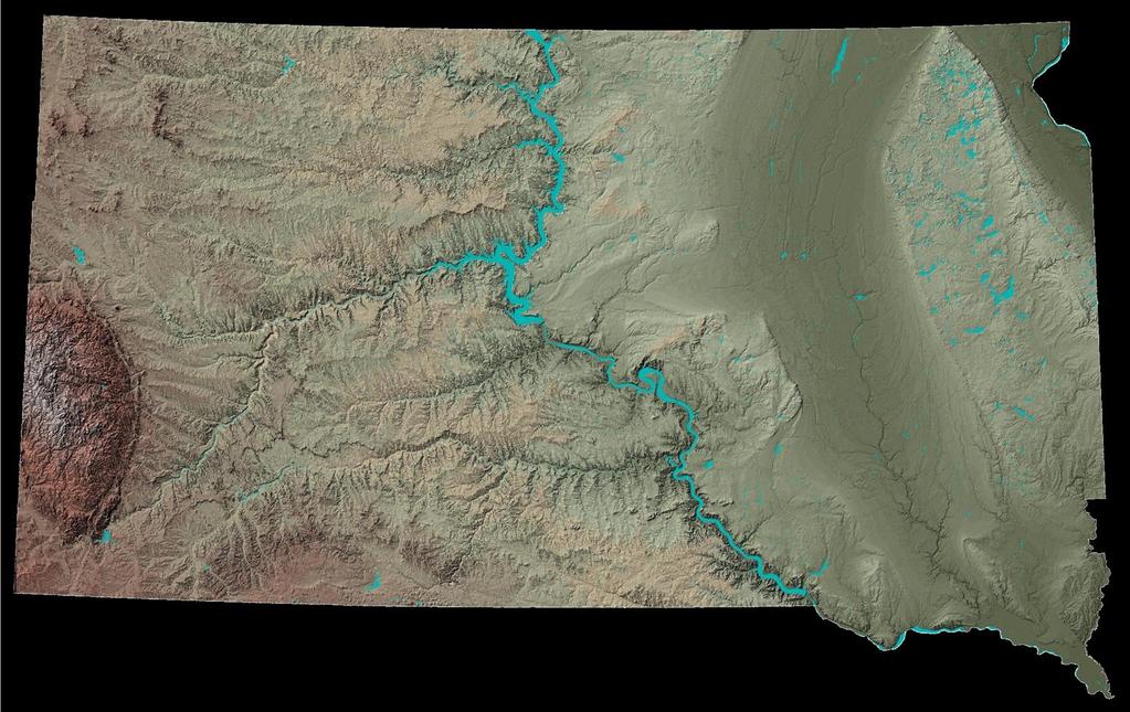
4 Locations of oil and gas drilling in South Dakota (approximately 1,883 drill sites)

5 Taken from

6 Taken from

7 Minerals and Mining Program web page at Click on these links for information on: Wells Production and injection Locations of drilling

8 Extent of Bakken and Three Forks Formations in North Dakota This is why the activity and development that we hear about in North Dakota related to the Bakken has not occurred in South Dakota. Map taken from North Dakota Geological Survey Geologic Investigations No. 64; published in 2008


9 DENR s Oil and Gas Initiative Purpose: To increase interest, exploration, development, and production.


10 Approximately 9,959 geophysical logs from approximately 7,274 locations have been scanned into electronic formats These are used by geologists to interpret subsurface geology. Available upon request on CDs. Will be available for free online.
11
12


13

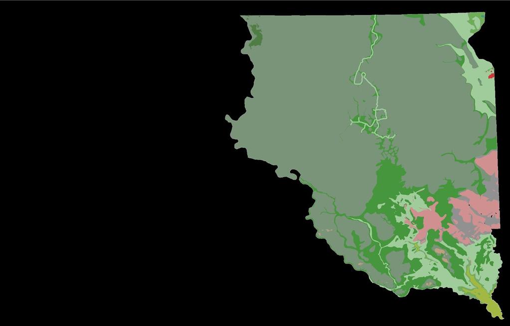
14 Bedrock geologic map of eastern South Dakota (2004) Shows the geology that exists directly under the glacial sediments The Niobrara Formation is a unit of interest
15 Stratigraphic correlation chart (2007, 2010) Shows which rock units are present in different parts of the state
 Listing of geologic units and their depths on the cross")
16 Cross sections showing the depth and distribution of rock units in South Dakota (2009) (An example of one of the 16 statewide cross sections) Listing of geologic units and their depths on the cross section

17 Elevation map of the Precambrian surface (2010) This is the hard rock surface below which the potential for oil and gas is essentially zero.
18 Precambrian Basement Terrane of South Dakota (2010) This map shows the pieces of the hard rock surface and some of its geologic structures under South Dakota. Information is useful in understanding rock layers that lie above this surface.
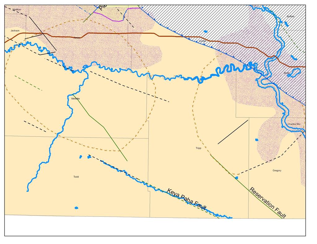
19 Influence of basement structure on surface drainage (Keya Paha fault versus Keya Paha River)
20
21
22

23 Field trip led by the Geological Survey Program and SDSM&T in Oct to highlight Black Hills area geology and its relevance to oil and gas. In progress activities A database of test hole and well information with formation-top elevations is being compiled. Work is ongoing to ensure that information is consistent for records that exist in multiple sources. Oil and gas files in DENR s Rapid City office are being prepared for scanning.
.")
.")
24 Geo-reference the Geological Survey Program s 110 paper maps of surface geology (1:62,500-scale). Planned activities Needed by scientists, industry, and consultants to make the maps usable in a Geographic Information System (GIS). Example: Geology of the Keyapaha quadrangle, South Dakota

25 Planned activities - continued Elevation and thickness maps are planned for 17 geologic units relevant to oil and gas Map showing thickness of the Minnelusa Formation An oil producer in South Dakota, Wyoming, Montana, and North Dakota New maps will be in ArcGIS digital format. Example of the type of map that will be created or updated with new information and put into digital format.

26 Planned activities - continued Maps of surface geology at a scale of 1:250,000 will be completed for all or parts of the areas outlined in yellow. Draft geologic map of the Lemmon 1⁰ x 2⁰ quadrangle

27 Planned activities - continued Scan oil and gas records. Provide online access to all scanned records. Generate data, maps, and reports for underexplored areas in South Dakota. Examine possibility of adding information about ownership of surface rights and mineral rights to DENR s web site. Design a web interface specifically for searching and accessing all pertinent oil and gas information.


28 We will continue to produce and disseminate reports, maps, and databases

29 Existing online databases Geological Survey Program web site Publications, maps, and data available for free download from Water quality Logs of drilling Core and cuttings Oil and gas Click on Online Databases SDGS publications Geologic bibliography


30 The Oil and Gas Initiative work plan and products are available through DENR s homepage and the Geological Survey Program s homepage. Click on Oil and Gas Initiative denr.sd.gov
31 Other DENR activities to promote oil and gas development Helped organize the celebration in 2004 held in Buffalo of the 50 th anniversary of oil discovery in South Dakota. Presented in 2004 at the American Association of Petroleum Geologists on unconventional gas sources in South Dakota. Presented in 2005 at the Geological Society of America meeting on the Pierre gas field. Presented at the 2006 Interstate Oil and Gas Compact Commission on South Dakota s Oil and Gas Initiative. Presented in 2006 at the Rocky Mountain Unconventional Gas Conference. Regularly present at the annual Williston Basin Petroleum Conference, most recently in Regularly represent South Dakota on the Interstate Oil and Gas Compact Commission. Help organize and give presentations at the annual SDSM&T oil and gas conference, most recently in Regularly provide information to individuals interested in developing oil and gas in South Dakota.
IN SOUTH DAKOTA PAST, PRESENT, AND FUTURE. GERALD (MACK) McGILLIVRAY OCTOBER 8-9, 2008
 McGILLIVRAY OCTOBER 8-9, 2008") SHALLOW GAS EXPLORATION & PRODUCTION IN SOUTH DAKOTA PAST, PRESENT, AND FUTURE BY GERALD (MACK) McGILLIVRAY 2009 ROCKY MOUNTAIN UNCONVENTIONAL GAS CONFERENCE OCTOBER 8-9, 2008 HISTORY OF SHALLOW GAS IN
SHALLOW GAS EXPLORATION & PRODUCTION IN SOUTH DAKOTA PAST, PRESENT, AND FUTURE BY GERALD (MACK) McGILLIVRAY 2009 ROCKY MOUNTAIN UNCONVENTIONAL GAS CONFERENCE OCTOBER 8-9, 2008 HISTORY OF SHALLOW GAS IN
Geologic Maps And Autocad
 Geologic Maps And Autocad 1 / 6 2 / 6 3 / 6 Geologic Maps And Autocad Geologic Maps And Autocad Digital geologic mapping is the process by which geological features are observed, analyzed, and recorded
Harvey Thorleifson, Director, Minnesota Geological Survey. Status of geological mapping needed for groundwater protection in Minnesota
 Harvey Thorleifson, Director, Minnesota Geological Survey Status of geological mapping needed for groundwater protection in Minnesota Minnesota is located between the Dakotas and Wisconsin, north of Iowa,
OIL AND GAS PLAYS OF THE MICHIGAN BASIN, SOUTHERN ONTARIO. Terry Carter, Consulting Geologist London, Ontario
 OIL AND GAS PLAYS OF THE MICHIGAN BASIN, SOUTHERN ONTARIO Terry Carter, Consulting Geologist London, Ontario 1 Ontario Petroleum Industries Oil and Natural Gas 1250 oil wells, 1200 gas wells, annual production
Geosciences Career Pathways (Including Alternative Energy)
") Geosciences Career Pathways (Including Alternative Energy) Shale Carbonates Clastics Unconventionals Geology Characterization and Production Properties of Gas Shales Geomechanics in International Shale
Geosciences Career Pathways (Including Alternative Energy) Shale Carbonates Clastics Unconventionals Geology Characterization and Production Properties of Gas Shales Geomechanics in International Shale
Outline Brief Overview MapPlace Website Data Delivery & Map Themes Digital Geology
 BRITISH COLUMBIA GEOLOGICAL SURVEY Kirk Hancock Pat Desjardins Nick Massey BRITISH COLUMBIA Ministry of Energy and Mines Ward Kilby acknowledged developer of MapPlace Outline Brief Overview MapPlace Website
Last Updated HYDROLOGIC ATLAS OF THE BLACK HILLS, PENNINGTON COUNTY, SOUTH DAKOTA
 Last Updated 10-29-2015 HYDROLOGIC ATLAS OF THE BLACK HILLS, PENNINGTON COUNTY, SOUTH DAKOTA INTRODUCTION The following is a brief outline of ground water characteristics in Pennington County, South Dakota.
Recap and Integrated Rock Mechanics and Natural Fracture Study on the Bakken Formation, Williston Basin Abstract Figure 1:
 Recap and Integrated Rock Mechanics and Natural Fracture Study on the Bakken Formation, Williston Basin Cosima Theloy, Department of Geology & Geological Engineering Abstract The late Devonian to early
USING EXISTING, PUBLICLY-AVAILABLE DATA TO GENERATE NEW EXPLORATION PROJECTS
 USING EXISTING, PUBLICLY-AVAILABLE DATA TO GENERATE NEW EXPLORATION PROJECTS Philip M. Baker 1, Paul A. Agnew 2 and M. Hooper 1 1 Rio Tinto Exploration, 37 Belmont Ave, Belmont WA 6104. Australia 2 Rio
PROGRESS IN 3D GEOLOGICAL MAPPING IN THE EASTERN PRAIRIES OF CANADA AND THE USA
 17 PROGRESS IN 3D GEOLOGICAL MAPPING IN THE EASTERN PRAIRIES OF CANADA AND THE USA Greg Keller 1, Gaywood Matile 1, and Harvey Thorleifson 2 1 Manitoba Geological Survey, Winnepeg, Manitoba, Canada, 2
Engaging a Tribal College in the Assessment of Oil and Gas Resources on a Sioux Indian Reservation
 1 Nov 2015 New Horizons O&G Conference field trip, Black Hills, SD, 2014 Engaging a Tribal College in the Assessment of Oil and Gas Resources on a Sioux Indian Reservation Geological Society of America
Mixed Reservoir Wetting in Unconventional Reservoirs and Interpretation of Porosity/Resistivity Cross Plots, Derived From Triple-combo Log Data
 Mixed Reservoir Wetting in Unconventional Reservoirs and Interpretation of Porosity/Resistivity Cross Plots, Derived From Triple-combo Log Data Michael Holmes DWLS November 14, 2017 Outline Introduction
Steve Whittaker, Petroleum Technology Research Centre Stephen Bend, University of Regina Ben Rostron, University of Alberta Gavin Jensen, Ministry of
 Steve Whittaker, Petroleum Technology Research Centre Stephen Bend, University of Regina Ben Rostron, University of Alberta Gavin Jensen, Ministry of Energy & Resources Williston Basin Petroleum Conference
THE DIGITAL TERRAIN MAP LIBRARY: AN EXPLORATIONIST S RESOURCE
 THE DIGITAL TERRAIN MAP LIBRARY: AN EXPLORATIONIST S RESOURCE By I.C.L. Webster, P.J. Desjardins and W.E. Kilby KEYWORDS: digital terrain maps, digital terrain stability maps, surficial geology, GIS, raster
The International Mining & Minerals Association. The new home for mining and minerals professionals in the UK and overseas
 The International Mining & Minerals Association The new home for mining and minerals professionals in the UK and overseas IMMa embraces all the professions within the minerals industries: Exploration,
WWDC Green River Basin Plan II, Groundwater Study (Level I) WSGS USGS WRDS October 23, 2008 Green River Basin (GRB) Basin Advisory Group
 WSGS USGS WRDS October 23, 2008 Green River Basin (GRB) Basin Advisory Group") WWDC Green River Basin Plan II, Groundwater Study (Level I) WSGS USGS WRDS 2007-20092009 October 23, 2008 Green River Basin (GRB) Basin Advisory Group (BAG) Western Wyoming Community College, Rock Springs,
WWDC Green River Basin Plan II, Groundwater Study (Level I) WSGS USGS WRDS 2007-20092009 October 23, 2008 Green River Basin (GRB) Basin Advisory Group (BAG) Western Wyoming Community College, Rock Springs,
GeoWEPP Tutorial Appendix
 GeoWEPP Tutorial Appendix Chris S. Renschler University at Buffalo - The State University of New York Department of Geography, 116 Wilkeson Quad Buffalo, New York 14261, USA Prepared for use at the WEPP/GeoWEPP
Devonian Isopach and Structure Maps: Initial Results of the IEA Weyburn CO 2 Monitoring and Storage Project Area
 Devonian Isopach and Structure Maps: Initial Results of the IEA Weyburn CO 2 Monitoring and Storage Project Area L.K. Kreis, P.L. Thomas, R.B. Burke 1, and S.G. Whittaker Kreis, L.K., Thomas, P.L., Burke,
Central North Dakota Shallow Gas Potential A Historical Perspective
 Central Shallow Gas Potential A Historical Perspective David W. Fischer Fischer Oil and Gas, Inc. Fred J. Anderson Department CURRENT ND ACTIVITIES ONLINE BIBLIOGRAPHY OF SHALLOW GAS REFERENCES ONLINE
1 Complementary Access Tools
 ENERGY IHS AccuMap Shaped by industry and powered by IHS Markit information, AccuMap is a powerful and intuitive interpretation solution for the Canadian Energy Industry. 1 Complementary Access Tools AccuLogs
Unconventional Reservoir Development: The Role of Geoscience from a State Regulator s Perspective
 Unconventional Reservoir Development: The Role of Geoscience from a State Regulator s Perspective Nick Tew Alabama State Geologist and Oil and Gas Supervisor President, American Geosciences Institute Geological
MESOZOIC BASINS. North Carolina Geological Survey
 MESOZOIC BASINS North Carolina Geological Survey The 1823 organic act which created the North Carolina Geological Survey (NCGS) tasked us to examine, describe and map the geology, geologic hazards, and
Recap and Integrated Rock Mechanics and Natural Fracture Study in the Bakken Formation, Williston Basin
 Recap and Integrated Rock Mechanics and Natural Fracture Study in the Bakken Formation, Williston Basin EERC, 2011 Cosima Theloy PhD Candidate Department of Geology and Geological Engineering Colorado
Your web browser (Safari 7) is out of date. For more security, comfort and the best experience on this site: Update your browser Ignore
 is out of date. For more security, comfort and the best experience on this site: Update your browser Ignore") Your web browser (Safari 7) is out of date. For more security, comfort and the best experience on this site: Update your browser Ignore BEDRO CK For the complete encyclopedic entry with media resources,
Your web browser (Safari 7) is out of date. For more security, comfort and the best experience on this site: Update your browser Ignore BEDRO CK For the complete encyclopedic entry with media resources,
Utilization of Global Map for Societal Benefit Areas
 Utilization of Global Map for Societal Benefit Areas The Fourth GEOSS AP Symposium Bali Indonesia, 11th March 2010 Shuhei Kojima Geographical Survey Institute Ministry of Land, Infrastructure, Transport
4. GIS Implementation of the TxDOT Hydrology Extensions
 4. GIS Implementation of the TxDOT Hydrology Extensions A Geographic Information System (GIS) is a computer-assisted system for the capture, storage, retrieval, analysis and display of spatial data. It
AGGREGATE RESOURCES OF ONTARIO (ARO) METADATA
 METADATA") AGGREGATE RESOURCES OF ONTARIO (ARO) METADATA GENERAL INFORMATION Official Name of the Data Set or Information Holding: Aggregate Resources of Ontario Acronyms are Used to Identify the Data Set or Information
AGGREGATE RESOURCES OF ONTARIO (ARO) METADATA GENERAL INFORMATION Official Name of the Data Set or Information Holding: Aggregate Resources of Ontario Acronyms are Used to Identify the Data Set or Information
Natural Gas Assessment of the Arkoma Basin, Ouachita Thrust Belt, and Reelfoot Rift Introduction & Methodology Overview
 Natural Gas Assessment of the Arkoma Basin, Ouachita Thrust Belt, and Reelfoot Rift Introduction & Methodology Overview Upper Atoka incised channel deposit at Ozark, Arkansas Dave Houseknecht U.S. Department
Mineral Exploration Using GIS
 King Fahad University of Petroleum and Minerals City and Regional Planning Department CRP 514: Introduction to GIS Term 112 Mineral Exploration Using GIS Term paper presentation By Mutasim Osman ID # g201105050
Guidelines for Site-Specific Seismic Hazard Reports for Essential and Hazardous Facilities and Major and Special-Occupancy Structures in Oregon
 Guidelines for Site-Specific Seismic Hazard Reports for Essential and Hazardous Facilities and Major and Special-Occupancy Structures in Oregon By the Oregon Board of Geologist Examiners and the Oregon
Valley-Fill Sandstones in the Kootenai Formation on the Crow Indian Reservation, South-Central Montana
 DE-FG22-96BC14996--08 Valley-Fill Sandstones in the Kootenai Formation on the Crow Indian Reservation, South-Central Montana Quarterly Report April 1 - June 30, 1998 By David A. Lopez Work Performed Under
Stephanie B. Gaswirth and Kristen R. Mara
 U.S. Geological Survey Assessment of Undiscovered Resources in the Bakken and Three Forks Formations, Williston Basin, North Dakota, Montana, and South Dakota, 2013 Stephanie B. Gaswirth and Kristen R.
SIXTH SCHEDULE REPUBLIC OF SOUTH SUDAN MINISTRY OF PETROLEUM, MINING THE MINING (MINERAL TITLE) REGULATIONS 2015
 REGULATIONS 2015") SIXTH SCHEDULE REPUBLIC OF SOUTH SUDAN MINISTRY OF PETROLEUM, MINING THE MINING ACT, 2012 THE MINING (MINERAL TITLE) REGULATIONS 2015 Guidelines should be prepared by the Directorate of Mineral Development
SIXTH SCHEDULE REPUBLIC OF SOUTH SUDAN MINISTRY OF PETROLEUM, MINING THE MINING ACT, 2012 THE MINING (MINERAL TITLE) REGULATIONS 2015 Guidelines should be prepared by the Directorate of Mineral Development
Williston Basin Architecture and Hydrocarbon Potential in Eastern Saskatchewan and Western Manitoba
 Williston Basin Architecture and Hydrocarbon Potential in Eastern Saskatchewan and Western Manitoba Kim Kreis, Benoit Beauchamp 1, Ruth Bezys 2 Carol Martiniuk 3, and Steve Whittaker Kreis, L.K., Beauchamp,
SURVEY OF CLOSED AND ABANDONED MINES IN BRITISH COLUMBIA FOR ACID ROCK DRAINAGE I: REGIONAL PERSPECTIVE ABSTRACT
 SURVEY OF CLOSED AND ABANDONED MINES IN BRITISH COLUMBIA FOR ACID ROCK DRAINAGE I: REGIONAL PERSPECTIVE Stephen J. Day 1 and David P. Harpley 2 1 Norecol Environmental Consultants Ltd. 700-1090 West Fender
Yukon Presentation. January 2015
 Yukon Presentation January 2015 Disclaimer This presentation contains forward looking statements. All statements, other than statements of historical fact, included herein, including without limitation,
Airborne gravity gradiometer surveying of petroleum systems under Lake Tanganyika, Tanzania
 Airborne gravity gradiometer surveying of petroleum systems under Lake Tanganyika, Tanzania D. Roberts Beach Energy P. Roy Chowdhury CGG S. J. Lowe CGG A. N. Christensen CGG Outline Introduction Geology
Search and Discovery Article #10532 (2013)** Posted October 21, Abstract
** Posted October 21, Abstract") Utilizing the Delta Log R Method for Determining Total Organic Carbon of the Niobrara Formation, B Bench, Denver-Julesburg Basin, Colorado and Wyoming* Madeline K. Beitz 1, Robert Cunningham 2, and Lisa
Utilizing the Delta Log R Method for Determining Total Organic Carbon of the Niobrara Formation, B Bench, Denver-Julesburg Basin, Colorado and Wyoming* Madeline K. Beitz 1, Robert Cunningham 2, and Lisa
Short Course. Petroleum Geochemistry & Basin Evaluation. Available to EGI Corporate Associate Members. Overview. Objectives.
 Short Course Instructor: David Thul, M.Sc. Manager of Petroleum Geochemistry Petroleum Geochemistry & Basin Evaluation Available to EGI Corporate Associate Members Course Structure Lectures, presentation
Louisiana Transportation Engineering Conference. Monday, February 12, 2007
 Louisiana Transportation Engineering Conference Monday, February 12, 2007 Agenda Project Background Goal of EIS Why Use GIS? What is GIS? How used on this Project Other site selection tools I-69 Corridor
Reducing Complex Spatial Data Management Needs in and Upstream Oil and Gas Operations Team. Jason Wilson GIS Business Analyst SM Energy
 Reducing Complex Spatial Data Management Needs in and Upstream Oil and Gas Operations Team Jason Wilson GIS Business Analyst SM Energy Agenda About Myself and SM Energy The Challenge The Goal Solution
Integrated 3D Geological Model of the Mississippian Devonian Bakken Formation, Elm Coulee, Williston Basin: Richland County, Montana
 Integrated 3D Geological Model of the Mississippian Devonian Bakken Formation, Elm Coulee, Williston Basin: Richland County, Montana Adrian Almanza Colorado School of Mines Outline Location Stratigraphy
Structural Geology Laboratory.
 Structural Geology Wikipedia-Structural geology is the study of the threedimensional distribution of rock units with respect to their deformational histories. The primary goal of structural geology is
THURSTON COUNTY COMPREHENSIVE PLAN UPDATE
 THURSTON COUNTY COMPREHENSIVE PLAN UPDATE BOARD OF COUNTY COMMISSIONERS WORK SESSION JUNE 14, 2017 Land Use Natural Resources Transportation Housing Utilities Environment Economic Development Capital Facilities
Using LiDAR as an Oil and Natural Gas Exploration Tool
 Figure 1: The Face of the Matanuska Glacier outside of Palmer Alaska. The Matanuska is a good example of a small retreating alpine glacier. Fractures in the glacier allow meltwater to carry rock and sediment
MRD273-REV METADATA. Acronyms are Used to Identify the Data Set or Information Holding: MRD273-REV
 MRD273-REV METADATA GENERAL INFORMATION Official Name of the Data Set or Information Holding: Ontario Precambrian Bedrock Magnetic Susceptibility Geodatabase for 2001 to 2012 Acronyms are Used to Identify
Pros and Cons against Reasonable Development of Unconventional Energy Resources
 Pros and Cons against Reasonable Development of Unconventional Energy Resources Associate Professor Shteryo LYOMOV, Ph.D. Presentation outline Energy resources; Conventional and Unconventional energy resources;
Williston Basin Architecture and Hydrocarbon Potential: A Targeted Geoscience Initiative Project 1
 Williston Basin Architecture and Hydrocarbon Potential: A Targeted Geoscience Initiative Project 1 S.G. Whittaker Whittaker, S.G. (2005): Williston Basin architecture and hydrocarbon potential: A Targeted
Geosciences Data Digitize and Materialize, Standardization Based on Logical Inter- Domain Relationships GeoDMS
 Geosciences Data Digitize and Materialize, Standardization Based on Logical Inter- Domain Relationships GeoDMS Somayeh Veiseh Iran, Corresponding author: Geological Survey of Iran, Azadi Sq, Meraj St,
Mineral Resources Branch. Natural Resources
 Mineral Resources Branch Natural Resources ! Brian Fisher - Geologist / GIS Specialist - supervisor! Jeff Poole - Geologist / GIS Specialist - IMS specialist! John MacNeil - Geologist / GIS Specialist
DIRECTORY OF COAL MINES IN ILLINOIS
 DIRECTORY OF COAL MINES IN ILLINOIS Champaign County This directory accompanies the Illinois Coal Mines map or maps for this County. August 2018 Prairie Research Institute Illinois State Geological Survey
DIRECTORY OF COAL MINES IN ILLINOIS
 DIRECTORY OF COAL MINES IN ILLINOIS Edgar County This directory accompanies the Illinois Coal Mines map or maps for this County. August 2018 Prairie Research Institute Illinois State Geological Survey
Structure contours on Bone Spring Formation (Lower Permian), Delaware Basin
, Delaware Basin") Structure contours on Bone Spring Formation (Lower Permian), Delaware Basin By Ronald F. Broadhead and Lewis Gillard New Mexico Bureau of Geology and Mineral Resources, a division of New Mexico Tech, Socorro
Structure contours on Bone Spring Formation (Lower Permian), Delaware Basin By Ronald F. Broadhead and Lewis Gillard New Mexico Bureau of Geology and Mineral Resources, a division of New Mexico Tech, Socorro
Geofacets Seminar & Interactive Workshop
 Geofacets Seminar & Workshop University of Bergen Geofacets Seminar & Interactive Workshop UNIVERSITY OF BERGEN Sandra Merten Geofacets Product Manager University of Bergen, 22 March 2017 Geofacets Seminar
NOTICE CONCERNING COPYRIGHT RESTRICTIONS
 NOTICE CONCERNING COPYRIGHT RESTRICTIONS This document may contain copyrighted materials. These materials have been made available for use in research, teaching, and private study, but may not be used
Placer Potential Map. Dawson L and U se P lan. Jeffrey Bond. Yukon Geological Survey
 Placer Potential Map Dawson L and U se P lan By Jeffrey Bond Yukon Geological Survey Dawson Land Use Plan Placer Potential Map 1.0 Introduction Placer mining has been an important economic driver within
COURSE OUTLINE GEOL204 MINING COMPUTING 3 CREDITS
 COURSE OUTLINE GEOL204 MINING COMPUTING 3 CREDITS PREPARED BY: Joel Cubley, Instructor DATE: June 1, 2018 APPROVED BY: Margaret Dumkee, Dean DATE: June 1, 2018 APPROVED BY ACADEMIC COUNCIL: May 2014 GEOL204
DISTRICTS, MINES, AND GEOCHEMISTRY DATABASES IN NEW MEXICO. Virginia T. McLemore and Maureen Wilks
 DISTRICTS, MINES, AND GEOCHEMISTRY DATABASES IN NEW MEXICO Virginia T. McLemore and Maureen Wilks ACKNOWLEDGEMENTS New Mexico Energy, Minerals and Natural Resource Department Company annual reports Personal
Hydrogen Index as a Maturity Proxy - Some Pitfalls and How to Overcome Them*
 Hydrogen Index as a Maturity Proxy - Some Pitfalls and How to Overcome Them* Mark H. Tobey 1 and Catherine E. Campbell 2 Search and Discovery Article #41964 (2016)** Posted December 12, 2016 *Adapted from
Digital Datasets Available from the Exploration & Mining Division. Dr. Wayne R. Cox, Senior Geologist, Exploration & Mining Division, DCENR.
 Digital Datasets Available from the Exploration & Mining Division Dr. Wayne R. Cox, Senior Geologist, Exploration & Mining Division, DCENR. Who Are EMD? Line Division of DCENR Small Unit (4 Geological
Summary. Simple model for kerogen maturity (Carcione, 2000)
") Malleswar Yenugu* and De-hua Han, University of Houston, USA Summary The conversion of kerogen to oil/gas will build up overpressure. Overpressure is caused by conversion of solid kerogen to fluid hydrocarbons
Malleswar Yenugu* and De-hua Han, University of Houston, USA Summary The conversion of kerogen to oil/gas will build up overpressure. Overpressure is caused by conversion of solid kerogen to fluid hydrocarbons
Outline. What is MapPlace? MapPlace Toolbar & PopUp Menu. Geology Themes 1:5M 1:1M BCGS 1:250,000. Terranes
 Outline BRITISH COLUMBIA Overview and Explore MapPlace Website Data Delivery & Map Themes Data Sources & Updates Feature Topics New Data & Maps New MINFILE Online Exploration Assistant with Image Analysis
The Canadian Ceoscience Knowledge Network. - A Collaborative Effort for Unified Access to Ceoscience Data
 The Canadian Ceoscience Knowledge Network - A Collaborative Effort for Unified Access to Ceoscience Data The Canadian Geoscience Knowledge Network A Collaborative Effort for Unified Access to Geoscience
PETROBRAS-REPLAN, Environmental Division, Rodovia SP 332 km 132, , Paulínia, SP, Brazil.
 GIS_EM (Geographic Information System for Environmental Monitoring) - A software implemented at Paulínia Refinery (REPLAN) for management of environmental data L.T. Furlan 1, C.D.D.G. Jungklaus 2, J. Ferreira
The Need for Regional Geological Datasets
 The Need for Regional Geological Datasets Dr. Eibhlín Doyle PGeo Geological Survey of Ireland Regional Data Why What Who Future 2006 Why? Place developments in context Land use decision making Assist policy
John Baldwin and Brian Gray Lettis Consultants International, Inc. Alexis Lavine AMEC Josh Goodman and Janet Sowers Fugro Consultants, Inc.
 John Baldwin and Brian Gray Lettis Consultants International, Inc. Alexis Lavine AMEC Josh Goodman and Janet Sowers Fugro Consultants, Inc. December 1, 2011 Pacific Gas & Electric SSHAC Workshop 1 San
STRATIGRAPHIC RESERVOIR CHARACTERIZATION FOR PETROLEUM GEOLOGISTS GEOPHYSICISTS AND ENGINEERS VOLUME
 STRATIGRAPHIC RESERVOIR CHARACTERIZATION FOR PETROLEUM GEOLOGISTS GEOPHYSICISTS AND ENGINEERS VOLUME page 1 / 5 page 2 / 5 stratigraphic reservoir characterization for pdf Flow-units verification, using
Exploring the Marcellus Shale using ArcGIS 3D Analyst
 Exploring the Marcellus Shale using ArcGIS 3D Analyst Advanced GIS GEOG/ES 490 Wednesday, May 5, 2010 Matthew M. Brown Project Background The Marcellus Shale is a subsurface rock formation that has recently
MRD 229-Revised METADATA
 GENERAL INFORMATION MRD 229-Revised METADATA Official Name of the Data Set or Information Holding: Till Compositional Database: Investigation of the Overburden Signature of the Caribou Lake Greenstone
THE USE OF GIS IN GEOTHERMAL RESOURCE MANAGEMENT: A CASE STUDY OF OLKARIA GEOTHERMAL PROJECT
 Presented at SDG Short Course II on Exploration and Development of Geothermal Resources, organized by UNU-GTP, GDC and KenGen, at Lake Bogoria and Lake Naivasha, Kenya, Nov. 9-29, 2017. Kenya Electricity
GEOL 220A Geologic Field Experiences: West Virginia Spring Term, 2008
 GEOL 220A Geologic Field Experiences: West Virginia Spring Term, 2008 Dr. Fred Soster Office: 216 Julian S&M e-mail: fsoster@depauw.edu Phone: 658-4670 Meeting Times: 2:15-3:15 p.m., Monday & Wednesday;
The Global Statistical Geospatial Framework and the Global Fundamental Geospatial Themes
 The Global Statistical Geospatial Framework and the Global Fundamental Geospatial Themes Sub-regional workshop on integration of administrative data, big data and geospatial information for the compilation
PRESENTATION TITLE. Anti-Collision Best Practices Developed for Horizontal Drilling Across Preexisting. Erin Britton & Rachel Grande
 1 PRESENTATION TITLE Industry Steering Committee on Wellbore Survey Accuracy Developed for Horizontal Drilling Across Preexisting Wellbore Horizontal Positioning Technical Wellbores Section Erin Britton
ALASKA GEOLOGICAL SOCIETY PUBLICATIONS Stratigraphic And Structure Sections
 ALASKA GEOLOGICAL SOCIETY PUBLICATIONS 2007-2008 Stratigraphic And Structure Sections Price Western Alaska Bristol Bay Region Stratigraphic Correlation Sections (CD)... $12.00 AGS Member Price... $10.00
Compiling historic YCGC data for lower Hunker Creek and reconstructing gold distribution. Sydney van Loon Yukon Geological Survey
 Compiling historic YCGC data for lower Hunker Creek and reconstructing gold distribution Sydney van Loon Yukon Consolidated Gold Corp. inventoried creeks for over four decades; operated up to 12 dredges
Horizontal gradient and band-pass filter of aeromagnetic data image the subsurface structure; Example from Esh El Mellaha Area, Gulf of Suez, Egypt.
 Horizontal gradient and band-pass filter of aeromagnetic data image the subsurface structure; Example from Esh El Mellaha Area, Gulf of Suez, Egypt. Essam Aboud 1, Serguei Goussev 2, Hassan Hassan 2, Suparno
How to Identify and Properly Classify Drill Cuttings
 How to Identify and Properly Classify Drill Cuttings (Creating Useful Borehole Logs) Dave Larson Hydrogeology and Geophysics Section Accurate information about the borehole location and a careful description
stress direction are less stable during both drilling and production stages (Zhang et al., 2006). Summary
. Summary") Inversion and attribute-assisted hydraulically-induced microseismic fracture prediction: A North Texas Barnett Shale case study Xavier E. Refunjol *, Katie M. Keranen, and Kurt J. Marfurt, The University
Inversion and attribute-assisted hydraulically-induced microseismic fracture prediction: A North Texas Barnett Shale case study Xavier E. Refunjol *, Katie M. Keranen, and Kurt J. Marfurt, The University
A Standardized Digital Well-Record Database for the Glaciated U.S.
 A Standardized Digital Well-Record Database for the Glaciated U.S. Randy Bayless and Les Arihood U.S. Geological Survey, Indiana Water Science Center, Indianapolis, IN Howard Reeves U.S. Geological Survey,
NEW PRODUCTS AND ADVANCEMENTS IN 3-D MODELLING PROTOCOLS BASED ON STUDIES IN THICK DRIFT AREAS IN ONTARIO, CANADA
 NEW PRODUCTS AND ADVANCEMENTS IN 3-D MODELLING PROTOCOLS BASED ON STUDIES IN THICK DRIFT AREAS IN ONTARIO, CANADA Abigail K. Burt and Andrew F. Bajc Ontario Geological Survey, 933 Ramsey Lake Road, Sudbury,
Ground-Water Exploration in the Worthington Area of Nobles County: Summary of Seismic Data and Recent Test Drilling Results
 Ground-Water Exploration in the Worthington Area of Nobles County: Summary of Seismic Data and Recent Test Drilling Results Jim Berg and Todd Petersen Geophysicists, DNR Waters January 2000 Table of Contents
Michigan s Geology and Groundwater
 Michigan s Geology and Groundwater Ralph J. Haefner Deputy Director U.S. Geological Survey Michigan-Ohio Water Science Center Lansing, Michigan Outline About the USGS Geology 101 Michigan s geology Bedrock
Uncovering the greater McArthur Basin, Northern Territory Tania Dhu Manager Geophysics and Remote Sensing, Northern Territory Geological Survey
 Uncovering the greater McArthur Basin, Northern Territory Tania Dhu Manager Geophysics and Remote Sensing, Northern Territory Geological Survey www.minerals.nt.gov.au Why focus on the McArthur Basin? Large,
LANDSLIDE HAZARD ANALYSIS AND ITS EFFECT ON ENDANGERED SPECIES HABITATS, GRAND COUNTY, UTAH
 12/5/2016 LANDSLIDE HAZARD ANALYSIS AND ITS EFFECT ON ENDANGERED SPECIES HABITATS, GRAND COUNTY, UTAH GIS Final Project Ashlyn Murphy Fall 2016 1. Introduction and Problem A well-known geologic hazard
Geographic Information Systems In Petroleum Exploration And Development (AAPG Computer Applications In Geology, No. 4) (Aapg Computer Applications In
 (Aapg Computer Applications In") Geographic Information Systems In Petroleum Exploration And Development (AAPG Computer Applications In Geology, No. 4) (Aapg Computer Applications In Geology, No. 4) By Timothy C. Coburn If searched for
Geographic Information Systems In Petroleum Exploration And Development (AAPG Computer Applications In Geology, No. 4) (Aapg Computer Applications In Geology, No. 4) By Timothy C. Coburn If searched for
Supplemental Data Data Sources for the Basement DEM
 GSA Data Repository 2017115 Stephen Marshak, Stefanie Domrois, Curtis Abert, Timothy Larson, Gary Pavlis, Michael Hamburger, Xiaotao Yang, Hersh Gilbert, and Chen Chen, 2017, The basement revealed: Tectonic
Overview of Selected Shale Plays in New Mexico*
 Overview of Selected Shale Plays in New Mexico* Ron Broadhead 1 Search and Discovery Article #10627 (2014)** Posted August 18, 2014 *Adapted from presentation at RMAG luncheon meeting, Denver, Colorado,
Raster Data Enhancement and Tectonic Element Interpretation in ArcMap
 Raster Data Enhancement and Tectonic Element Interpretation in ArcMap Vsevolod Egorov ESRI Petroleum User Group Conference Houston, TX 2005 Abstract ArcMap Spatial Analyst provides quick, but powerful
ALASKA GEOLOGICAL SOCIETY PUBLICATIONS. Stratigraphic And Structure Sections
 ALASKA GEOLOGICAL SOCIETY PUBLICATIONS 2010 Stratigraphic And Structure Sections Price Western Alaska Bristol Bay Region Stratigraphic Correlation Sections (CD)...Item # WA01... $12.00 AGS Member Price...
MRD 207 METADATA DETAIL PAGE
 MRD 207 METADATA DETAIL PAGE The following represents the Basic description of an information holding. To obtain more information about this holding, see the section named Contacts. GENERAL INFORMATION
Prospectivity Modelling of Granite-Related Nickel Deposits Throughout Eastern Australia
 Prospectivity Modelling of Granite-Related Nickel Deposits Throughout Eastern Australia M P Hill 1 and A McCarthy 2 ABSTRACT Spatial modelling has been used to determine potential locations of granite-related
Earth Sciences at the University of Windsor
 Earth Sciences at the University of Windsor Research Foci in Earth Sciences Geochemistry Al-Aasm, Fryer, Fowle, Polat, Samson Environment Al-Aasm, Cioppa, Fryer, Fowle, Graniero, Lakhan, Lavalle, Rietsma,
Block 43B - Onshore Oman
 Block 43B - Onshore Oman SUMMARY Block 43B is an 11,967 km 2 area located along the coastal area of Oman north of the Hajar Mountains. This is an unexplored region, both geographically and stratigraphically.
A method for three-dimensional mapping, merging geologic interpretation, and GIS computation
 A method for three-dimensional mapping, merging geologic interpretation, and GIS computation Soller, David R., U.S. Geological Survey, 908 National Center, Reston, VA 20192 and Richard C. Berg, Illinois
Your web browser (Safari 7) is out of date. For more security, comfort and. the best experience on this site: Update your browser Ignore
 is out of date. For more security, comfort and. the best experience on this site: Update your browser Ignore") Your web browser (Safari 7) is out of date. For more security, comfort and Activitydevelop the best experience on this site: Update your browser Ignore Extracting Gas from Shale How is natural gas extracted
Your web browser (Safari 7) is out of date. For more security, comfort and Activitydevelop the best experience on this site: Update your browser Ignore Extracting Gas from Shale How is natural gas extracted
Sequence Stratigraphy of the Upper Cretaceous Niobrara Formation, A Bench, Wattenberg Field, Denver Julesburg Basin, Colorado*
 Sequence Stratigraphy of the Upper Cretaceous Niobrara Formation, A Bench, Wattenberg Field, Denver Julesburg Basin, Colorado* Lisa E. Remington LaChance 1 and Mark C. Robinson 1 Search and Discovery Article
Improvements on 2D modelling with 3D spatial data: Tin prospectivity of Khartoum, Queensland, Australia
 Improvements on 2D modelling with 3D spatial data: Tin prospectivity of Khartoum, Queensland, Australia C. E. Payne, F. W. Cunningham, A. J. Wilkins & G. A. Partington Kenex Ltd. Outline Prospectivity
v WMS Tutorials GIS Module Importing, displaying, and converting shapefiles Required Components Time minutes
 v. 11.0 WMS 11.0 Tutorial Importing, displaying, and converting shapefiles Objectives This tutorial demonstrates how to import GIS data, visualize it, and convert it into WMS coverage data that could be
Improving Well Performance through Multi Variate Completion Analyses in the US Bakken Shale. C. Mark Pearson
 Improving Well Performance through Multi Variate Completion Analyses in the US Bakken Shale C. Mark Pearson Liberty Resources LLC Denver, CO Slide 2 An independent, private-equity backed E&P company with
DGS Digital Geologic Information Resource (DGIR) User Guide
 User Guide") DGS Digital Geologic Information Resource (DGIR) User Guide Developed by the Delaware Geological Survey. Revised January 2012. TABLE OF CONTENTS I. INTRODUCTION II. DGIR LAYOUT III. TOOLBARS IV. USING
DGS Digital Geologic Information Resource (DGIR) User Guide Developed by the Delaware Geological Survey. Revised January 2012. TABLE OF CONTENTS I. INTRODUCTION II. DGIR LAYOUT III. TOOLBARS IV. USING