Implication of drainage basin parameters for the Bunbuni River Basin in Chotanagpur Plateau region, India
|
|
|
- Vivien Johnston
- 6 years ago
- Views:
Transcription
1 IOSR Journal Of Humanities And Social Science (IOSR-JHSS) Volume 21, Issue12, Ver. 4 (December. 2016) PP e-issn: , p-issn: Implication of drainage basin parameters for the Bunbuni River Basin in Chotanagpur Plateau region, India Sumitra Mandi*¹ Kalicharan Soren*² *¹Assistant Teacher, Birendranagar High School, Hooghly (W.B.) India *² Lab.attendent, School of water resource Engg. Jadavpur university Kol (W.B.) India Abstract : A morphometric evaluation of Bunbuni basin was carried out to determine the drainage characteristics. Total study area is Km². Rivers are the active processes which have a tendency to change the channel morphology and hydrological characteristics by the attrition and deposition. The average slope of the study area varies from 0 in the North West to above 8 towards south west. The slope variation is controlled by the local lithology and erosion cycles. Basin morphometry is a means of numerically analyzing or precisely quantifying different aspects of a drainage basin. The morphometric parameters considered for analysis includes the areal and relief aspects of the basin. The study has strengthened in perceptive the hydrological, geological and geomorphological characteristics of the Bunbuni drainage basin. Keywords - Morphometric evaluation, areal & relief aspects, attrition, Bunbuni river basin. I. INTRODUCTION Morphometric investigation reveals to quantitative evaluation of form exclusivity of landscape. Drainage basin provides an perfect unit of the landscape and as such the quantitative evaluation of drainage networks of a basin can give useful clues to perceptive the earth surface form and processes. Supplementary, river channels being the most responsive geomorphic features responding to any change in geographical factors viz. lithology and tectonics as well as climate, morphometric parameters are projected to reflect mutual control of these factors. The composition of the stream system of a drainage basin is expressed quantitatively with Area ratio, Drainage density. It incorporates various components such as, stream segments, basin length, basin parameters, basin area, altitude, volume, slope, profiles of the land which indicates the nature of development of the basin. There are overabundance of literature on drainage basin morphometry that have contributed towards understanding drainage development in the light of controlling variables in a particular geological terrain and a number of general bivariate relationship have been established (Strahler 1952, 1957, 1958, and 1964; Schumm, 1956; Morisawa, 1957, 1958; Scheidegger, 1965; Hack, 1973; Shreve, 1967; Gregory, 1968; Gregory and Walling, 1973 and Keller and Pinter 1996). Here we present the Areal and relief morphometric parameters of Bunbuni river basin of Chotanagpur plateau region to see their conformity with available understanding on drainage development and landform evolution. II. MATERIALS AND METHODS The Survey of India Toposheet number is 72 L/2 on the scale of 1: 50,000 were used for the present study. The different Areal and relief aspects of the morphometric parameters have been used. Microsoft Excel 2007 is use to enumerates the data analysis and MapInfo-11.0 software has helped in the preparation of different thematic maps. III. LOCATION OF STUDY AREA The Bunbuni river basin bordered between latitude N to N and longitude E to E in Survey of India Toposheet numbers 72L/2 and having area of about km² ( Fig. 1). The Bunbuni river is one of the tributary of the Bhoriwajor river and Bhoriwajor river is a tributary of river Kiur. This study area has a striking climate. For five to six months of the year, from October onward the days are bright and stimulating. The mean temperature in December is 23 C (73 F). The nights are cool and temperatures in winter may drop below freezing point in many places. In April and May the day temperature may cross 38 C (100 F) but it is extremely dry and no humid as in the adjoining plains. The rainy season (June to September) is pleasurable. The study area receives an yearly average rainfall of around 1,400 millimetres (55 in), which is less than the rain forested areas of much of India and almost all of it in the monsoon months between June and August. The Bunbuni river basin shows well developed dendritic to sub dendritic type drainage pattern (Fig 1). In the present paper the authors had made an attempt to morphometric analysis of Bunbuni river basin. DOI: / Page


2 Fig: 1 Location map of the study area. IV. RESULTS AND DISCUSSIONS Some selected techniques are adopted to show the areal and relief aspects of the basin as follows Areal aspects: Area ratio, Drainage density. Relief aspects: Relative relief, Dissection index, Ruggedness index, Average slope etc. 4.1 Areal aspects of the basin The areal aspects of a drainage basin expose regional features like lithology, geological structure, climatic conditions and denudation history of the basin. These aspects control the spatial arrangement, geometrical shape and form of drainage systems, river discharge and runoff characteristics [1]. Areal aspects of a drainage basin includes Area ratio, Drainage density. These aspects suggest immediate necessity of water conservation measures in the upstream catchment areas of the Bunbuni river basin, to enhance infiltration of surface runoff into the sub-surface for restoration and provisions of the spring sources Area ratio (Ar) Area ratio reveals ratio of increase of mean basin areas between two successive orders and it can be expressed by following equation. [1] Ar=Au/Au 1 [1] Where, Au is mean area of a given order of the basin. When, Au = Au /Nu Nu = Number of all segments of a given order. Au = Total area of all stream segments of the same order. DOI: / Page
3 Table: 1 Showing Stream Order wise area of the Bunbuni River basin Stream Order Basin Area in Km² Basin Area in % Cumulative Basin area in % 1 st nd rd th th Fig: 2 Relationship between Stream order and Cumulative basin area of the study area Drainage density (Dd) Drainage density indicates to the total stream lengths per unit area. Drainage density as a ratio of total length of all stream segments in a given drainage basin to the total area of that basin [3] [4] and thus it can be Expressed as follows - Dd =Lu/A Where, Lu =Total stream length of all orders, A =Total area of the basin, Km². Drainage density values for the Bunbuni river basin is 0.37 Km 1 representing low drainage densities. The type of rock also affects the drainage density usually lower values of Dd tend to take place on granite, gneiss, and schist regions. But the single values for the whole basin which does not agree to the accepting of spatial variation of these aspects over the whole basin. In case the spatial variation can be originate out by dividing the basin into one square Kilometer grids and then by assemblage the data so derived into different categories. For Bunbuni river basin following zone has been recognized. (Fig 3) Table: 2 Showing Drainage density of the Bunbuni River basin Drainage Area (in km²) Area in density Percentage Above DOI: / Page

 in per unit area. The Relative relief of Bunbuni river basin is 397 m.")
4 Fig: 3 Drainage Density map of the study area. 4.2 Relief aspects of the basin Relief aspects of a drainage basin reproduce the topographical gradient characteristics of the basin and present a bird s eye view of the whole area. The relief aspect of drainage basin includes elevation of highest and lowest point in the basin, Relative relief, Dissection index, Ruggedness index, Average slope etc Relative relief: Relative relief is defined as the difference in height between the highest and the lowest points (height) in per unit area. The Relative relief of Bunbuni river basin is 397 m. The Relative relief represents an actual differentiation of elevation in a unit area with reverence to its local base level. Relative relief is an indicator of the general steepness of a basin from high point to mouth. It is more noteworthy and also valuable in accepting morphogenesis. For Bunbuni river basin subsequent categories is recognized. (Fig 4) Table: 3 Showing Relative relief of the Bunbuni River Basin Relative Area (in km²) Area in relief Percentage Above Fig: 4 Relative Relief map of the study area. DOI: / Page

5 Table: 4 Showing Dissection index of the Bunbuni River Basin. Dissection Area (in km²) Area in index Percentage Above Fig: 5 Dissection Index map of the study area Dissection Index Dissection index indicates a ratio of the maximum relative relief to the maximum absolute height. It is a significant morphometric indicator of the nature and amount of dissection of terrain. DI =R/Max Where, R = Relative relief, Max = Maximum elevation of the basin (m)... (Dovnir 1957) For Bunbuni river basin following categories is identified. (Fig 5) Ruggedness Index RI is an appraised of surface ruggedness, instead of sharpness of local relief and the amplitude of available drainage density and other environmental parameters. RI is calculated by taking into account both relief and drainage [5]. In this analysis shown that the high classes of RI are found in south and south western region of the study area (Fig 6). Table: 5 Showing Dissection index of the Bunbuni River Basin. Ruggedness Area (in km²) Area in Index Percentage Above DOI: / Page

6 Fig: 6 Ruggedness Index map of the study area Average Slope Slope, separate as angular inclinations of terrain between hill-tops and valley bottoms, significant from the amalgamation of several contributing factors like geological structure, absolute and relative reliefs, climate, vegetal cover, drainage texture and drainage frequency, dissection index etc. are noteworthy morphometric attributes in the study of landforms of a drainage basin. Calculation of slope angles from topographical map or through field dimension involves tedious and time overriding procedures. Numerous technique have been recommended through time to time e.g. J L Rich (1916), C.K Wentworth (1930), G.H.Smith (1938),(1939),E. Raize and J Henry (1937), W.C.Calef (1950),W.C calef and R New comb (1953), A. N Strahler (1956) etc, but the techniques of Wentworth being easier and involving lesser measurement and calculating and more swift procedure than other schemes has been widely used by several Geomorphologists. For the groundwork of the average slope map the study area be divided into 2 2 cm grids each having straight lines at right angles and the number of contour crossing along the boundaries of grids are counted and then substantial from tan values are obtained from log table. (Fig 7) Slope in degree tan Q= N/4 /C.I / Where N/4=Average no of contour crossing. N- No of contour crossing. C.I Contour interval = Constant value. Table: 6 showing the Average slope of the Bunbuni river basin. Slope in c Area (in km²) Area in percentage Above DOI: / Page

 (b) (c) (d)")
, (b), (c),")


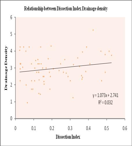
7 Fig: 7 Average slope map of the study area. (a) (b) (c) (d) (e) (f) Fig: 8 (a), (b), (c), (d), (e) and (f) had shown the relationship between different morphometric attributes of the study area. DOI: / Page
8 V. CONCLUSION Based on the morphometric analysis the results show that the local relief characteristics with some observation of structural landscape pattern of the Bunbuni river basin. It is shown that the high absolute relief area is surrounded in the south western region. Spatial distribution of relative relief at some location indicates symmetrical distribution, which indicates inactive tectonic in the area. Low value of dissection index is found almost whole valley except few places of south western portion of the study area. Higher the value of dissection index and the topographic ruggedness indexes are calculated over the region, indicating less undulation and stability of the terrain/land surface. Therefore, it is suggested that the attained outcome to be utilized in hydrological, physical characteristics, and environmental management in the Bunbuni river basin. REFERENCES [1] S.Singh (Ed.), Geomorpology (Allahabad: Prayag Pustak Bhawan), pp [2] A.N. Strahler, Quantitative geomorphology of drainage basins and channel networks In. Handbook of Applied Hydrology, McGraw Hill Book Company, New York,Section 4II, [3] R.E Horton, Drainage basin characteristics, Trans.Amer. Geophys. U.14, (1932), pp [4] R.E. Horton, Erosional development of streams and their drainage basins: hydrophysical approach to quantitative morphology, Bull. Geol. Soc. Amer.,5 1945,pp [5] R.J Chorley, Kennedy BA (Eds.) 1971, Physical Geography: A systematic approach, p 370 (London, prentice Hall). [6] S.A Schumm, The evolution of drainage system and slopes in Badlands at Perth Amboy, New Jersey, Bulletin of Geological Society of America, 67,( 1956) pp [7] J.I Clarke, (1966), Morphometry from maps, in: Dury,G.H. (Ed), Essays in Geomorphology, American Elsevier Publ. Co., New York, pp [8] S.A Schumm, The evolution of drainage system and slopes in Badlands at Perth Amboy, New Jersey,Bulletin of Geological Society of America, 67,( 1956) pp [9] V.C.Miller, A quantitative geomorphic study of drainage basin characteristics in the Clinch Mountain area, Varginia and Tennessee, 1953, Project NR389042,Tech. Rept.3.,Columbia University, Department of Geology, ONR, Geography Branch, New York. [10] R.J Chorley, Donald,E.G., Malm., and Pogorzelski,H.A., A new standard for estimating drainage basin shape, Amer. Jour. Sci.,255, 1957, pp [11] K.G. Smith,, Standards for grading texture of erosional topography, Amer. Jour.Sci.,248, 1950 pp [12] R. J. Chorley, S. A Schumm,. And D.E., Sugden,Geomorphology, Methuen and Co. Ltd., London, (1985), pp [13] S L. Dingman FLUVIAL HYDRAULICS Copyright 2009 by Oxford University Press. [14] D. Knighton. Fluvial forms and processes A new perspective. Arnold publication (1998). [15] L.B Leopold, M.G Wolman and J.P.Miller, Fluvial processes in geomorphology, Eurasia Publishing House, New Delhi. (1969). [16] A. Miller, the skin of the earth. Methuen & Co. Ltd., London (1953). [17] M. Morisawa, Rivers-forms and process, Longman group, London, (1985), pp and [18] P.K Sen., Geomorphological analysis of drainage basins, the University of Burdwan, Burdwan (1993).R.L Singh, India-a regional geography, National geographical society of India, Varanasi. (2008). [19] M.A Summerfield, Global geomorphology, Prentice Hall, New Delhi, (1991), pp [20] S. Ghosh. Geomorphic land evaluation for sustainable use of lands resource in Puruliya district, W. B. Journal of landscape systems and ecological studies, 2012(June) vol.35 (1). pp [21] N.S Magesh and N. Chandrasekar. and J.Arab GIS model-based morphometric evaluation of Tamiraparani subbasin, Tirunelveli district, Tamil Nadu, India DOI /s Geosci z Saudi Society for Geosciences DOI: / Page
Morphometric Analysis Of Bhogavati River Basin, Kolhapur District, Maharashtra, India.
 IOSR Journal of Mechanical and Civil Engineering (IOSR-JMCE) ISSN: 2278-1684, PP: 01-08 www.iosrjournals.org Morphometric Analysis Of Bhogavati River Basin, Kolhapur District, Maharashtra, India. P. A.
MORPHOMETRIC ANALYSIS OF ADYAR WATERSHED
 MORPHOMETRIC ANALYSIS OF ADYAR WATERSHED A.K.Bharadwaj 1,Pradeep.C 2,D.Thirumalaivasan 3,C.P.Shankar 4, N.Madhavan 5 1,2,3,4,5 Institute of Remote Sensing, Anna University, Guindy, Chennai, India- 600025.
About the Author: E mail ID: Contact: proceedings. Page 1 of 8
 Catchment Delineation and Morphometric Analysis Using Geographical Information System of Naina Gorma Basin of Rewa District, M.P., India Vimala Singh 1, L.K. Sinha 2 Research Associate 1, DTRL, DRDO Scientist
Morphometric Analysis of Shaliganga Sub Catchment, Kashmir Valley, India Using Geographical Information System
 Morphometric Analysis of Shaliganga Sub Catchment, Kashmir Valley, India Using Geographical Information System Mohd Iqbal 1, Haroon Sajjad 1, F.A. Bhat 2 1 Department of Geography, Faculty of Natural Sciences,
Morphometric Estimation of Parameters of Uttar Mand River Basin, Satara District, Maharashtra, India.
 Morphometric Estimation of Parameters of Uttar Mand River Basin, Satara District, Maharashtra, India. Mr.S.S.Chokakkar 1, Mr.G.N.ChavanPatil, Dr.D.N.Mudgal 3, Dr..Shreenivasa 4 1M.Sc., B.Ed, NET, PhD(Pur.)
Gis Based On Morphometric Analysis of Part of Manair River Basin in Karimnagar District, Telangana State.
 IOSR Journal of Applied Geology and Geophysics (IOSR-JAGG) e-issn: 0990, p-issn: 098.Volume, Issue Ver. II (Sep. Oct. 07), PP 0-07 www.iosrjournals.org Gis Based On Morphometric Analysis of Part of Manair
International Journal of Research (IJR) Vol-1, Issue-10 November 2014 ISSN
 Vol-1, Issue-10 November 2014 ISSN") Morphological Parameter Estimation Derived From ASTER-DEM Using GIS and Remote Sensing Techniques A Study on Hosakote Watershed of Dakshina Pinakini River Basin, Karnataka, India K. Satish 1* and H.C.
Morphological Parameter Estimation Derived From ASTER-DEM Using GIS and Remote Sensing Techniques A Study on Hosakote Watershed of Dakshina Pinakini River Basin, Karnataka, India K. Satish 1* and H.C.
MORPHOMETRIC ANALYSIS OF LAKSHMANTIRTHA RIVER BASIN AROUND HUNSUR TALUK, MYSORE, KARNATAKA, (INDIA)
") MORPHOMETRIC ANALYSIS OF LAKSHMANTIRTHA RIVER BASIN AROUND HUNSUR TALUK, MYSORE, KARNATAKA, (INDIA) Nilufer Arshad* and G.S. Gopalakrishna DOS in Geology University of Mysore, Mysore, (INDIA) Received
MORPHOMETRIC ANALYSIS OF LAKSHMANTIRTHA RIVER BASIN AROUND HUNSUR TALUK, MYSORE, KARNATAKA, (INDIA) Nilufer Arshad* and G.S. Gopalakrishna DOS in Geology University of Mysore, Mysore, (INDIA) Received
Morphometric Analysis of Jiya Dhol River Basin
 Morphometric Analysis of Jiya Dhol River Basin Luna Moin Das North-Eastern Hill University, Shillong Abstract: Basin morphometry is an important means of understanding a drainage basin using mathematically
INTERNATIONAL JOURNAL OF GEOMATICS AND GEOSCIENCES Volume 2, No 1, 2011
 INTERNATIONAL JOURNAL OF GEOMATICS AND GEOSCIENCES Volume 2, No 1, 2011 Copyright 2010 All rights reserved Integrated Publishing services Research article ISSN 0976 4380 Hypsometric Analysis of Varattaru
MORPHOMETRY OF BUGGAVANKA WATERSHED IN KADAPA, ANDHRA PRADESH, INDIA USING SPATIAL INFORMATION TECHNOLOGY
 BEST: International Journal of Humanities, Arts, Medicine and Sciences (BEST: IJHAMS) ISSN 2348-0521 Vol. 3, Issue 2, Feb 2015, 1-8 BEST Journals MORPHOMETRY OF BUGGAVANKA WATERSHED IN KADAPA, ANDHRA PRADESH,
GIS based quantitative morphometric analysis and its consequences: a case study from Shanur River Basin, Maharashtra India
 Appl Water Sci (2017) 7:861 871 DOI 10.1007/s13201-015-0298-7 ORIGINAL ARTICLE GIS based quantitative morphometric analysis and its consequences: a case study from Shanur River Basin, Maharashtra India
Chapter 5. Morphometric Control on Food
 Chapter 5 Morphometric Control on Food Key Words: Morphometry, Linear Morphometry, Areal Morphometry, Relief Morphometry, Morphometric Control and Flood 5.1 Morphometric Aspects Drainage basin or basins
PRIORITIZATION BASED ON MORPHOMETRIC ANALYSIS OF DUDHGANGA CATCHMENT,KASHMIR VALLEY, INDIA. USING REMOTE SENSING & GEOGRAPHIC INFORMATION SYSTEM.
 ISSN: 2307-6992 Available Online: http://ajgr.rstpublishers.com/ PRIORITIZATION BASED ON MORPHOMETRIC ANALYSIS OF DUDHGANGA CATCHMENT,KASHMIR VALLEY, INDIA. USING REMOTE SENSING & GEOGRAPHIC INFORMATION
Morphometric analysis of Kharlikani watershed in Odisha, India using spatial information technology Kishor Choudhari 1, Panigrahi B 2, Paul J.
 INTERNATIONAL JOURNAL OF GEOMATICS AND GEOSCIENCES Volume 4, No 4, 2014 Copyright 2010 All rights reserved Integrated Publishing services Research article ISSN 0976 4380 Morphometric analysis of Kharlikani
Geographical Information System Based Morphometric Analysis of Halia Drainage Area, Nalgonda District, Andhra Pradesh, India
 Geographical Information System Based Morphometric Analysis of Halia Drainage Area, Nalgonda District, Andhra Pradesh, India Sarala.C Associate Professor, Centre for Water Resources, Institute of Science
INTERNATIONAL JOURNAL OF GEOMATICS AND GEOSCIENCES Volume 1, No 4, 2011
 Morphometric analysis of Nanjangud taluk, Mysore District, Karnataka, India, using GIS Techniques Mahadevaswamy.G 1, Nagaraju.D 1, Siddalingamurthy.S 1, Lakshmamma 1, Mohammad Subhan lone, Nagesh.P.C 2,
Chapter IV MORPHOMETRIC ANALYSIS AND STREAM NETWORK CHARACTERISTICS IN GADAG DISTRICT
 Chapter IV MORPHOMETRIC ANALYSIS AND STREAM NETWORK CHARACTERISTICS IN GADAG DISTRICT 4.1 INTRODUCTION: Streams and rivers are the most dynamic parts of the earth s physical environment. The behavior of
Morphometric Analysis of Chamundi Hills, Mysuru, India Using Geographical Information System
 Volume-7, Issue-1, January-February 2017 International Journal of Engineering and Management Research Page Number: 279-283 Morphometric Analysis of s, Mysuru, India Using Geographical Information System
Morphometric Analysis of Gostani River Basin in Andhra Pradesh State, India Using Spatial Information Technology
 Morphometric Analysis of Gostani River Basin in Andhra Pradesh State, India Using Spatial Information Technology Nageswara Rao.K 1,Swarna Latha.P 2, Arun Kumar.P 3,Hari Krishna.M 2 1 Department of Civil
University Grants Commission, New Delhi Recognized Journal No ISSN: Print: ISSN: Online: X
 Morphometric Analysis of Lower Bhavani River Basin, Using Geographical Information System Ipsita Pradhan 1, Dr S.Vasudevan 2, R. Selvaganapathi 3, G. Sathiyamoorthy 4, Subhrajit Das 5 1,3,4,5 Ph.D. Research
MORPHOMETRIC ANALYSIS OF WATERSHEDS IN THE KUNIGAL AREA OF TUMKUR DISTRICT, SOUTH INDIA USING REMOTE SENSING AND GIS TECHNOLOGY
 MORPHOMETRIC ANALYSIS OF WATERSHEDS IN THE KUNIGAL AREA OF TUMKUR DISTRICT, SOUTH INDIA USING REMOTE SENSING AND GIS TECHNOLOGY PROJECT REFERENCE NO. : 37S1170 COLLEGE : SIDDAGANGA INSTITUTE OF TECHNOLOGY,
MORPHOMETRIC ANALYSIS OF RAJGARDH WATERSHED OF MADHYA PRADESH
 International Journal of Civil Engineering and Technology (IJCIET) Volume 8, Issue 4, April 2017, pp. 1319 1328 Article ID: IJCIET_08_04_149 Available online at http://www.iaeme.com/ijciet/issues.asp?jtypeijciet&vtype8&itype4
A Case Study: Morphometric Characteristics of Sub-Watershed (P- 17) in Paras Region, Akola District, Maharashtra, India using Remote Sensing & GIS
 in Paras Region, Akola District, Maharashtra, India using Remote Sensing & GIS") Cloud Publications International Journal of Advanced Earth Science and Engineering 2017, Volume 6, Issue 1, pp. 492 499 ISSN: 2320 3609, Crossref: 10.23953/cloud.ijaese.236 Case Study Open Access A Case
Cloud Publications International Journal of Advanced Earth Science and Engineering 2017, Volume 6, Issue 1, pp. 492 499 ISSN: 2320 3609, Crossref: 10.23953/cloud.ijaese.236 Case Study Open Access A Case
Simplify Equation to Calculate Elongation River Basin Proposed by Schumm (1956)
") Simplify Equation to Calculate Elongation River Basin Proposed by Schumm (1956) Dr. Saad.A.Mubark.aldarraji.Assisent Professor. Department of Geography. Faculty of Education.Ibn Rushed. Baghdad University.
Simplify Equation to Calculate Elongation River Basin Proposed by Schumm (1956) Dr. Saad.A.Mubark.aldarraji.Assisent Professor. Department of Geography. Faculty of Education.Ibn Rushed. Baghdad University.
International Journal of Innovative Research in Advanced Engineering (IJIRAE) ISSN: Issue 09, Volume 3 (September 2016)
 ISSN: Issue 09, Volume 3 (September 2016)") Quantitative evaluation and analysis of morphometric parameters derived from ASTER DEM using ARC Hydro tool in a GIS Environment A study of Vaishali River Basin of Madhya Pradesh Monika Sharma S.N.Mohapatra
Quantitative evaluation and analysis of morphometric parameters derived from ASTER DEM using ARC Hydro tool in a GIS Environment A study of Vaishali River Basin of Madhya Pradesh Monika Sharma S.N.Mohapatra
Prioritization of sub-watersheds in semi arid region, Western Maharashtra, India using Geographical Information System
 American Journal of Engineering Research (AJER) e-issn : 2320-0847 p-issn : 2320-0936 Volume-02, Issue-10, pp-128-135 www.ajer.org Research Paper Open Access Prioritization of sub-watersheds in semi arid
Morphometric Analysis for Hard Rock Terrain of Upper Ponnaiyar Watershed, Tamilnadu A GIS Approach
 International Journal of Research Studies in Science, Engineering and Technology Volume 1, Issue 9, December 2014, PP 205-209 ISSN 2349-4751 (Print) & ISSN 2349-476X (Online) Morphometric Analysis for
Hypsometric analysis of the Tuirini drainage basin: A Geographic Information System approach
 INTERNATIONAL JOURNAL OF GEOMATICS AND GEOSCIENCES Volume 6, No 3, 26 Copyright by the authors - Licensee IPA- Under Creative Commons license 3. Research article ISSN 976 438 Hypsometric analysis of the
Morphometric Analysis for Evaluating Groundwater Potential Zones, In Kusangai Jor Watershed Area, Dist. Bolangir, Orissa.
 Morphometric Analysis for Evaluating Groundwater Potential Zones, In Kusangai Jor Watershed Area, Dist. Bolangir, Orissa. Alokesh Chatterjee 1, Asish Tantubay 1 1 Department of Geology, Presidency College,
Morphometric Analysis of Siswan Drainage Basin, Punjab (India) using Geographical Information System
 using Geographical Information System") 11 Morphometric Analysis of Siswan Drainage Basin, Punjab (India) using Geographical Information System Gursewak Singh Brar, Research Scholar, Department of Geography, Panjab University, Chandigarh ABSTRACT
11 Morphometric Analysis of Siswan Drainage Basin, Punjab (India) using Geographical Information System Gursewak Singh Brar, Research Scholar, Department of Geography, Panjab University, Chandigarh ABSTRACT
A STUDY ON MORPHOMETRIC PARAMETER OF A WATERSHED FOR SUSTAINABLE WATER CONSERVATION
 International Journal of Civil Engineering and Technology (IJCIET) Volume 8, Issue 9, September 2017, pp. 271 278, Article ID: IJCIET_08_09_031 Available online at http://http://www.iaeme.com/ijciet/issues.asp?jtype=ijciet&vtype=8&itype=9
Morphometric Analysis of Sonbhadra Sub- Watershed of Tawa Reservoir Catchment Area of Hoshangabad District, Madhya Pradesh using GIS Techniques
 IJIRST International Journal for Innovative Research in Science & Technology Volume 2 Issue 07 December 2015 ISSN (online): 2349-6010 Morphometric Analysis of Sonbhadra Sub- Watershed of Tawa Reservoir
Sub-watershed prioritization based on potential zones of Kuttiadi river basin, A Geo-Morphometric approach using GIS
 INTERNATIONAL JOURNAL OF GEOMATICS AND GEOSCIENCES Volume 8, No 1, 2018 Copyright by the authors - Licensee IPA- Under Creative Commons license 3.0 Research article ISSN 0976 4380 Sub-watershed prioritization
Prioritization of Sub Watersheds using Morphometric Analysis: A Remote Sensing and GIS Perspective
 Prioritization of Sub Watersheds using Morphometric Analysis: A Remote Sensing and GIS Perspective Love Kumar 1, D. Khalkho* 2, P. Katre 3, G. K. Nigam 4 Ph.D. Scholar, SVCAET & RS, FAE, IGKV, Raipur,
CHAPTER 4 THE INFLUENCE OF RIVER BASIN MORPHOLOGY ON RIVER GROUNDWATER INTERACTION
 CHAPTER 4 THE INFLUENCE OF RIVER BASIN MORPHOLOGY ON RIVER GROUNDWATER INTERACTION CHAPTER 4 THE INFLUENCE OF RIVER BASIN MORPHOLOGY ON RIVER-GROUNDWATER INTERACTION 4.0. INTRODUCTION The relationship
Keywords: Morphometry, Upper river basin, Remote sensing GIS, spatial information technology
 A STUDY OF MORPHOMETRIC ANALYSIS USING REMOTE SENSING TECHNIQUES OF UPPER NIRA DRAINAGE BASIN, MAHARASHTRA Anuradha Ohal Dept. of Geography Tilak Maharashtra Vidyapeeth, Pune ABSTRACT Nira is tributary
Evaluation of Morphometric parameters of drainage networks derived from Topographic Map and Digital Elevation Model using Remote Sensing and GIS
 INTERNATIONAL JOURNAL OF GEOMATICS AND GEOSCIENCES Volume 5, No 4, 2015 Copyright by the authors - Licensee IPA- Under Creative Commons license 3.0 Research article ISSN 0976 4380 Evaluation of Morphometric
CHAPTER 4 MORPHOMETRICAL FEATURES OF CHITRAVATHI BASIN
 41 CHAPTER 4 MORPHOMETRICAL FEATURES OF CHITRAVATHI BASIN The importance of morphometric studies in general and drainage basin studies in particular is clearly expressed by Christopher Gerrard (1989-99,
CHAPTER V WATERSHED CHARACTERIZATION USING GIS
 61 CHAPTER V WATERSHED CHARACTERIZATION USING GIS 5.1 GENERAL: In this chapter, introduction to watershed characterization and analysis has been presented in the first part. Methodology to compute important
INTERNATIONAL JOURNAL OF ENVIRONMENTAL SCIENCES Volume 3, No 1, Copyright by the authors - Licensee IPA- Under Creative Commons license 3.
 INTERNATIONAL JOURNAL OF ENVIRONMENTAL SCIENCES Volume 3, No 1, 2012 Copyright by the authors - Licensee IPA- Under Creative Commons license 3.0 Review article ISSN 0976 4402 Morphometric analysis and
MOUNTAIN ORDERING: A METHOD FOR CLASSIFYING MOUNTAINS BASED ON THEIR MORPHOMETRY
 Earth Surface Processes and Landforms Earth Surf. Process. Landforms 24, 653±660 (1999) MOUNTAIN ORDERING: A METHOD FOR CLASSIFYING MOUNTAINS BASED ON THEIR MORPHOMETRY SHUJI YAMADA Department of Geography,
, Horton , km Tsinghua Tongfang Optical Disc Co., Ltd. All rights reserved. Vol. 21, No. 2 GEO GRAPHICAL RESEARCH
 21 2 2002 3 Vol. 21, No. 2 GEO GRAPHICAL RESEARCH Mar., 2002 : 100020585 (2002) 0220171208 (, 100101) :, 50 500 2500, 6 15,,,,,, : ; ; : P93111 ; P33314 : A, [1, Horton 1942 ], [2 10, ],,,,,,,,,,,,,, 50
MORPHOMETRIC ANALYSIS OF TURSIQ BASIN EAST OF IRAQ USING REMOTE SENSING AND GIS TECHNIQUES
 MORPHOMETRIC ANALYSIS OF TURSIQ BASIN EAST OF IRAQ USING REMOTE SENSING AND GIS TECHNIQUES Mutasim Ibrahim. Malik, Sarteel Hamid AL-Shammary, Sajad Abudlkadhem AL-yasry Waist University, College of Science,
DRAINAGE BASIN MORPHOLOGY. Morphometric analysis is defined as the numerical
 C H A P T E R 3 DRAINAGE BASIN MORPHOLOGY 3.1 Introduction Morphometric analysis is defined as the numerical systematization of landform elements measured from topographic maps and provides real basis
MORPHOMETRIC ANALYSIS OF SUB-BASINS IN JAISAMAND CATCHMENT USING GEOGRAPHICAL INFORMATION SYSTEM
 IMPACT: International Journal of Research in Engineering & Technology (IMPACT: IJRET) ISSN(E): 2321-8843; ISSN(P): 2347-4599 Vol. 2, Issue 6, Jun 2014, 189-202 Impact Journals MORPHOMETRIC ANALYSIS OF
Morphometric Analysis of Singki River Catchment using Remote Sensing & GIS: Papumpare, Arunachal Pradesh
 Cloud Publications International Journal of Advanced Remote Sensing and GIS 2017, Volume 6, Issue 1, pp. 2023-2032 ISSN 2320 0243, Crossref: 10.23953/cloud.ijarsg.32 Research Article Open Access Morphometric
OBJECTIVES. Fluvial Geomorphology? STREAM CLASSIFICATION & RIVER ASSESSMENT
 STREAM CLASSIFICATION & RIVER ASSESSMENT Greg Babbit Graduate Research Assistant Dept. Forestry, Wildlife & Fisheries Seneca Creek, Monongahela National Forest, West Virginia OBJECTIVES Introduce basic
AN ANALYSIS OF THE LAWS OF DRAINAGE NET COMPOSITION
 AN ANALYSIS OF THE LAWS OF DRAINAGE NET COMPOSITION L.E. MILTON Australia M.S. submitted February 1965 ABSTRACT Two of the geomorphic Laws of Drainage Net Composition are discussed and it is shown that
MORPHOLOGICAL PARAMETER ESTIMATION DERIVED FROM TOPOSHEETS AND ASTER DEM A STUDY ON WATERSHEDS OF DAKSHINA PINAKINI RIVER BASIN IN KARNATAKA, INDIA
 International Journal of Applied and Natural Sciences (IJANS) ISSN 2319-4014 Vol. 2, Issue 4, Sep 2013, 125-134 IASET MORPHOLOGICAL PARAMETER ESTIMATION DERIVED FROM TOPOSHEETS AND ASTERDEM A STUDY ON
ESTIMATION OF MORPHOMETRIC PARAMETERS AND RUNOFF USING RS & GIS TECHNIQUES
 ESTIMATION OF MORPHOMETRIC PARAMETERS AND RUNOFF USING RS & GIS TECHNIQUES Shrudha. V. K¹, Hafeezunnisa² 1 Assistant Professor, Rajarajeshwari College of Engineering Bangalore 2 Assistant Engineer, WRDO
Indian Journal of Spatial Science
 Indian Journal of Spatial Science EISSN: 2249-4316 ISSN: 2249-3921 journal homepage: www.indiansss.org Relief Analysis of the Tangri Watershed in the Lower Shivalik and Piedmont Zone of Haryana and Punjab
Each basin is surrounded & defined by a drainage divide (high point from which water flows away) Channel initiation
 Channel initiation") DRAINAGE BASINS A drainage basin or watershed is defined from a downstream point, working upstream, to include all of the hillslope & channel areas which drain to that point Each basin is surrounded &
DRAINAGE BASINS A drainage basin or watershed is defined from a downstream point, working upstream, to include all of the hillslope & channel areas which drain to that point Each basin is surrounded &
Journal of Environment and Earth Science ISSN (Paper) ISSN (Online) Vol. 4, No.5, 2014
 ISSN (Online) Vol. 4, No.5, 2014") Preparation of Geomorphological Map and Their Characterisation with the help of Remote Sensing and GIS: a case study of Sankha Nadi Drainage Basin Sadhan Malik Guest Lecturer, Memari College, University
Preparation of Geomorphological Map and Their Characterisation with the help of Remote Sensing and GIS: a case study of Sankha Nadi Drainage Basin Sadhan Malik Guest Lecturer, Memari College, University
Geomorphological Analysis of Aralamallige Watershed, Bangalore Using Remote Sensing and GIS Approach
 International Journal of Research Studies in Biosciences (IJRSB) Volume 2, Issue 1, February 2014, PP 6-10 www.arcjournals.org Geomorphological Analysis of Aralamallige Watershed, Bangalore Using Remote
CAUSES FOR CHANGE IN STREAM-CHANNEL MORPHOLOGY
 CAUSES FOR CHANGE IN STREAM-CHANNEL MORPHOLOGY Chad A. Whaley, Department of Earth Sciences, University of South Alabama, MobileAL, 36688. E-MAIL: caw408@jaguar1.usouthal.edu The ultimate goal of this
Current World Environment
 ISSN: 0973-4929, Vol. 12, No. (3) 2017, Pg. 635-645 Current World Environment Journal Website: www.cwejournal.org Morphometric Analysis of Kadvi River basin, Maharashtra Using Geospatial Techniques Sujit
Chapter 4 : Morphometric Analysis
 Chapter : Morphometric Analysis. Introduction Geology, geomorphology, structure and drainage patterns especially in hard rock terrains are the primary determinants of river ecosystem functioning at the
INTERNATIONAL JOURNAL OF PURE AND APPLIED RESEARCH IN ENGINEERING AND TECHNOLOGY
 INTERNATIONAL JOURNAL OF PURE AND APPLIED RESEARCH IN ENGINEERING AND TECHNOLOGY A PATH FOR HORIZING YOUR INNOVATIVE WORK SPECIAL ISSUE FOR NATIONAL LEVEL CONFERENCE "SUSTAINABLE TECHNOLOGIES IN CIVIL
FOREST RESEARCH INSTITUTE, DEHRADUN
 PROJECT REPORT DRAINAGE AND REPLENISHMENT STUDY OF MINED AREA OF GANGA SHYAMPUR RIVER HARIDWAR Submitted to UTTARAKHAND FOREST DEVELOPMENT CORPORATION (UFDC) 73, Nehru Road, Deharadun Prepared&Submitted
16 th Esri India User Conference 2015
 PRIORITIZATION OF SUB-WATERSHEDS FOR SUSTAINABLE DEVELOPMENT AND MANAGEMENT OF NATURAL RESOURCES: AN INTEGRATED APPROACH USING REMOTE SENSING, GIS TECHNIQUES. Abstract: B. S. Manjare Department of Geology
Morphometric Properties of Bulkana (NaftKhanah) North-East Iraq from Topographic Maps
 North-East Iraq from Topographic Maps") Research Article International Journal of Current Engineering and Technology E-ISSN 2277 4106, P-ISSN 2347-5161 2014 INPRESSCO, All Rights Reserved Available at http://inpressco.com/category/ijcet Morphometric
Research Article International Journal of Current Engineering and Technology E-ISSN 2277 4106, P-ISSN 2347-5161 2014 INPRESSCO, All Rights Reserved Available at http://inpressco.com/category/ijcet Morphometric
INTERNATIONAL JOURNAL OF GEOMATICS AND GEOSCIENCES Volume 3, No 3, 2013
 INTERNATIONAL JOURNAL OF GEOMATICS AND GEOSCIENCES Volume 3, No 3, 2013 Copyright by the authors - Licensee IPA- Under Creative Commons license 3.0 Research article ISSN 0976 4380 Morphometric analysis
Influence of Terrain on Scaling Laws for River Networks
 Utah State University DigitalCommons@USU All Physics Faculty Publications Physics 11-1-2002 Influence of Terrain on Scaling Laws for River Networks D. A. Vasquez D. H. Smith Boyd F. Edwards Utah State
Drainage Morphometric Analysis of Watershed Basin of River Beas at Harike Pattan, Punjab-Using Remote Sensing and GIS Approach
 Drainage Morphometric Analysis of Watershed Basin of River Beas at Harike Pattan, Punjab-Using Remote Sensing and GIS Approach Gh Nabi Najar* 1, Puneeta Pandey* 2 1,2 *Centre for Environmental Sciences
A comparative study of the Morphometric Analysis of High land sub-watersheds of Meenachil and Pamba Rivers of Kerala, Western Ghats, South India
 International Journal of Innovation and Scientific Research ISSN 2351-8014 Vol. 11 No. 2 Nov. 2014, pp. 527-532 2014 Innovative Space of Scientific Research Journals http://www.ijisr.issr-journals.org/
INTERNATIONAL JOURNAL OF GEOMATICS AND GEOSCIENCES Volume 2, No 1, 2011
 INTERNATIONAL JOURNAL OF GEOMATICS AND GEOSCIENCES Volume 2, No 1, 2011 Copyright 2010 All rights reserved Integrated Publishing services Research article ISSN 0976 4380 Quantitative and Spatial Analysis
Morphometric Analysis of a Phulambri River Drainage Basin (Gp8 Watershed), Aurangabad District (Maharashtra) using Geographical Information System
, Aurangabad District (Maharashtra) using Geographical Information System") Cloud Publications International Journal of Advanced Remote Sensing and GIS 2016, Volume 5, Issue 6, pp. 1813-1828 ISSN 2320-0243, Crossref: 10.23953/cloud.ijarsg.62 Research Article Open Access Morphometric
Cloud Publications International Journal of Advanced Remote Sensing and GIS 2016, Volume 5, Issue 6, pp. 1813-1828 ISSN 2320-0243, Crossref: 10.23953/cloud.ijarsg.62 Research Article Open Access Morphometric
MORPHOMETRIC ANALYSIS OF KOSI RIVER SUB WATERSHED IN RAMNAGAR, UTTARAKHAND USING GIS AND REMOTE SENSING TECHNIQUES
 MORPHOMETRIC ANALYSIS OF KOSI RIVER SUB WATERSHED IN RAMNAGAR, UTTARAKHAND USING GIS AND REMOTE SENSING TECHNIQUES Saif Said Associate Professor, Civil Engineering Department, Aligarh Muslim University,
Morphometric Characteristics of Dikrong River Catchment in the Foot-Hills of Arunachal Himalayas
 IOSR Journal Of Humanities And Social Science (IOSR-JHSS) Volume 22, Issue 7, Ver.13 (July.2017) PP 51-60 e-issn: 2279-0837, p-issn: 2279-0845. www.iosrjournals.org Morphometric Characteristics of Dikrong
WATERSHED CHARACHTERIZATION AND PRIORITIZATION OF TULASI SUBWATERSHED: A GEOSPATIAL APPROACH
 WATERSHED CHARACHTERIZATION AND PRIORITIZATION OF TULASI SUBWATERSHED: A GEOSPATIAL APPROACH V.S. Pawar-Patil 1, Sagar P. Mali 2 Assistant Professor, The New College, Kolhapur, India 1 Project Fellow,
Cihan UYSAL 1, Irfan AKAR 2, Gizem INCE 1, Derya MAKTAV 1, James CROW 3. Introduction
 The Determination and Comparison of the Hydrological Properties of Basins from Topographic Maps, DTM and SRTM DEMs. A Case Studyof Part of the Roman Water Supply System (Thrace, Turkey) Cihan UYSAL 1,
Gully erosion and associated risks in the Tutova basin Moldavian Plateau
 Landform Analysis, Vol. 17: 193 197 (2011) Gully erosion and associated risks in the Tutova basin Moldavian Plateau University Alexandru Ioan Cuza of Iasi, Department of Geography, Romania, e-mail: catiul@yahoo.com
Prashant P. Magar 1 and Nirupama P. Magar 2 1
 Journal of Indian Geomorphology Volume 4, 2016 ISSN 2320-0731 Indian Institute of Geomorphologists (IGI) Application of Hack s Stream Gradient Index (SL Index) to Longitudinal Profiles of the Rivers Flowing
ANALYSIS OF MORPHOMETRIC PARAMETERS OF A PAVANA RIVER BASIN, INDIA USING ASTER (DEM) DATA AND GIS
 DATA AND GIS") ANALYSIS OF MORPHOMETRIC PARAMETERS OF A PAVANA RIVER BASIN, INDIA USING ASTER (DEM) DATA AND GIS P.P. Choudhari Assistant Professor, University Department of Geography, University of Mumbai, Mumbai 400098,
ANALYSIS OF MORPHOMETRIC PARAMETERS OF A PAVANA RIVER BASIN, INDIA USING ASTER (DEM) DATA AND GIS P.P. Choudhari Assistant Professor, University Department of Geography, University of Mumbai, Mumbai 400098,
Geography Class XI Fundamentals of Physical Geography Section A Total Periods : 140 Total Marks : 70. Periods Topic Subject Matter Geographical Skills
 Geography Class XI Fundamentals of Physical Geography Section A Total Periods : 140 Total Marks : 70 Sr. No. 01 Periods Topic Subject Matter Geographical Skills Nature and Scope Definition, nature, i)
Morphometric analysis of Maun watershed in Tehri-Garhwal district of Uttarakhand using GIS
 INTERNATIONAL JOURNAL OF GEOMATICS AND GEOSCIENCES Volume 3, No 2, 2012 Copyright 2010 All rights reserved Integrated Publishing services Research article ISSN 0976 4380 Morphometric analysis of Maun watershed
River Processes. Drainage Basin Morphometry
 Drainage Basin Morphometry River Processes Morphometry - the measurement and mathematical analysis of the configuration of the earth s surface and of the shape and dimensions of its landforms. Horton (1945)
Watershed morphometric analysis of Wadi Baish Dam catchment area using integrated GIS-based approach
 Arab J Geosci (2017) 10: 256 DOI 10.1007/s12517-017-3046-5 ORIGINAL PAPER Watershed morphometric analysis of Wadi Baish Dam catchment area using integrated GIS-based approach Farid Radwan 1 & AA Alazba
QUANTITATIVE GEOMORPHOLOGY OF THE DRAINAGE BASIN IN SEMI-ARID ENVIRONMENT
 I" QUANTITATIVE GEOMORPHOLOGY OF THE DRAINAGE BASIN IN SEMI-ARID ENVIRONMENT BIMAL GROSE, S. PANDEY AND S SINGH Gentral Arid Zone Research Institute, Jodhpur INTRODUCTION In India Ghose et al (963, 967)
LANDSLIDE SUSCEPTIBILITY ANALYSIS FROM MORPHOMETRIC PARAMETER ANALYSIS OF RIYONG KHOLA BASIN, WEST SIKKIM, INDIA: A GEOSPATIAL APPROACH
 LANDSLIDE SUSCEPTIBILITY ANALYSIS FROM MORPHOMETRIC PARAMETER ANALYSIS OF RIYONG KHOLA BASIN, WEST SIKKIM, INDIA: A GEOSPATIAL APPROACH *Ghosh D. Department of Geography and Applied Geography, University
International Journal of Scientific & Engineering Research, Volume 4, Issue 11, November-2013 ISSN
 832 Detailed morphometric analysis of Man River Basin in Akola and Buldhana Districts of Maharashtra, India using Cartosat-1 (DEM) Data and GIS techniques Khadri, S.F.R and Kanak Moharir Department of
Chapter 1 Quantitative Analysis of Geomorphometric Parameters of Wadi Kerak, Jordan, Using Remote Sensing and GIS
 Chapter 1 Quantitative Analysis of Geomorphometric Parameters of Wadi Kerak, Jordan, Using Remote Sensing and GIS Yahya Farhan, Ali Anbar, Omar Enaba, Nisrin Al-Shaikh Geomorphometric analysis was carried
FEW MORPHOMETRIC CHARACTERISTICS AND THEIR IMPACT ON FLOODS USING REMOTE SENSING AND GIS TECHNIQUE IN THE GABHARU RIVER BASIN, ASSAM, INDIA
 J FE JOURNAL OF FLOOD ENGINEERING 6(1) January-June 2015; Pp. 37 51 International Science Press (India) ISSN : 0976-6219 FEW MORPHOMETRIC CHARACTERISTICS AND THEIR IMPACT ON FLOODS USING REMOTE SENSING
Spatial pattern of channel network in Jiuyuangou drainage basin
 Spatial pattern of channel network in Jiuyuangou drainage basin Zhang Ting *, Tang Guo-an, Liu Xueun, Zhou Yi, Jia Dunxin Key Laboratory of Virtual Geographic Environment (Naning Normal University), Ministry
Morphometric Analysis of Didessa River Catchment in Blue Nile Basin, Western Ethiopia
 DOI: http://dx.doi.org/10.4314/star.v3i3.31 ISSN: 2226-7522(Print) and 2305-3372 (Online) Science, Technology and Arts Research Journal Sci. Technol. Arts Res. J., July-Sep 2014, 3(3): 191-197 Journal
Laboratory Exercise #4 Geologic Surface Processes in Dry Lands
 Page - 1 Laboratory Exercise #4 Geologic Surface Processes in Dry Lands Section A Overview of Lands with Dry Climates The definition of a dry climate is tied to an understanding of the hydrologic cycle
MORPHOMETRIC ANALYSIS OF KHULGAD WATERSHED ALMORA, UTTARAKHAND
 MORPHOMETRIC ANALYSIS OF KHULGAD WATERSHED ALMORA, UTTARAKHAND Zainab Fatima 1 1 Interdisciplinary Dept. of Remote Sensing and GIs Application Aligarh Muslim University Aligarh Abstract-Rivers are the
Morphotectonic and Lineament analysis from Bhatia and Jaigarh Creek, Ratnagiri, MS, India: Neotectonic Implication
 International Research Journal of Earth Sciences ISSN 2321 2527 Int. Res.J. Earth Sci. Morphotectonic and Lineament analysis from Bhatia and Jaigarh Creek, Ratnagiri, MS, India: Neotectonic Implication
Topographic and morphometric analysis of Sebou watershed (Morocco) using geographic information system and digital elevation model
 using geographic information system and digital elevation model") International Research Journal of Earth Sciences ISSN 2321 2527 Topographic and morphometric analysis of Sebou watershed (Morocco) using geographic information system and digital elevation model Abstract
International Research Journal of Earth Sciences ISSN 2321 2527 Topographic and morphometric analysis of Sebou watershed (Morocco) using geographic information system and digital elevation model Abstract
CHAPTER 9 SUMMARY AND CONCLUSIONS
 CHAPTER 9 SUMMARY AND CONCLUSIONS The following are the important conclusions and salient features of the present study. 1. The evaluation of groundwater potential is a prerequisite for any kind of planning
3/3/2013. The hydro cycle water returns from the sea. All "toilet to tap." Introduction to Environmental Geology, 5e
 Introduction to Environmental Geology, 5e Running Water: summary in haiku form Edward A. Keller Chapter 9 Rivers and Flooding Lecture Presentation prepared by X. Mara Chen, Salisbury University The hydro
INTERNATIONAL JOURNAL OF GEOMATICS AND GEOSCIENCES Volume 6, No 2, 2015
 INTERNATIONAL JOURNAL OF GEOMATICS AND GEOSCIENCES Volume 6, No 2, 2015 Copyright by the authors - Licensee IPA- Under Creative Commons license 3.0 Research article ISSN 0976 4380 Mathematical analysis
International Journal of Scientific & Engineering Research, Volume 4, Issue 8, August ISSN
 International Journal of Scientific & Engineering Research, Volume 4, Issue 8, August-2013 508 Comparative Study of Morphometric Parameters Derived from Topographic Maps and ASTER DEM Ziaur Rehman Ansari
INTERNATIONAL JOURNAL OF GEOMATICS AND GEOSCIENCES Volume 2, No 2, 2011
 INTERNATIONAL JOURNAL OF GEOMATICS AND GEOSCIENCES Volume 2, No 2, 2011 Copyright 2010 All rights reserved Integrated Publishing services Research article ISSN 0976 4380 A GIS morphometric analysis of
International Journal of Remote Sensing & Geoscience (IJRSG) ASTER DEM BASED GEOLOGICAL AND GEOMOR-
 ASTER DEM BASED GEOLOGICAL AND GEOMOR-") ASTER DEM BASED GEOLOGICAL AND GEOMOR- PHOLOGICAL INVESTIGATION USING GIS TECHNOLOGY IN KOLLI HILL, SOUTH INDIA Gurugnanam.B, Centre for Applied Geology, Gandhigram Rural Institute-Deemed University, Tamilnadu,
ASTER DEM BASED GEOLOGICAL AND GEOMOR- PHOLOGICAL INVESTIGATION USING GIS TECHNOLOGY IN KOLLI HILL, SOUTH INDIA Gurugnanam.B, Centre for Applied Geology, Gandhigram Rural Institute-Deemed University, Tamilnadu,
Landscape Development
 CHAPTER 22 Landscape Development Chapter Summary Landscapes are described in terms of their topography: elevation, the altitude of the surface of the Earth above sea level; relief, the difference between
Using GIS Techniques and Quantitative Morphometric Analysis to Evaluate the Groundwater Resources in the Central Flinders Ranges, South Australia
 Using GIS Techniques and Quantitative Morphometric Analysis to Evaluate the Groundwater Resources in the Central Flinders Ranges, South Australia Alaa A. Ismail and Ian Clark Centre for Water Management
INTERNATIONAL JOURNAL OF APPLIED RESEARCH IN ENGINEERING AND TECHNOLOGY
 Research Article ISSN: 2319-507X INTERNATIONAL JOURNAL OF PURE AND APPLIED RESEARCH IN ENGINEERING AND TECHNOLOGY A PATH FOR HORIZING YOUR INNOVATIVE WORK GEOMORPHOLOGICAL INVESTIGATIONS OF GHATKHED MINII
Laboratory Exercise #3 The Hydrologic Cycle and Running Water Processes
 Laboratory Exercise #3 The Hydrologic Cycle and Running Water Processes page - 1 Section A - The Hydrologic Cycle Figure 1 illustrates the hydrologic cycle which quantifies how water is cycled throughout