QUANTITATIVE GEOMORPHOLOGY OF THE DRAINAGE BASIN IN SEMI-ARID ENVIRONMENT
|
|
|
- Philomena Newman
- 5 years ago
- Views:
Transcription
 have studied the geomorphic characteristics of drainage channels in the Luni Basin in the")
1 I" QUANTITATIVE GEOMORPHOLOGY OF THE DRAINAGE BASIN IN SEMI-ARID ENVIRONMENT BIMAL GROSE, S. PANDEY AND S SINGH Gentral Arid Zone Research Institute, Jodhpur INTRODUCTION In India Ghose et al (963, 967) have studied the geomorphic characteristics of drainage channels in the Luni Basin in the arid land of Rajasthan. In the present paper an attempt has been made to study the geomorphic cbaracteristics'of streams in 2 randomly selected drainage basins situated in semi-arid environment near Sumerpur (Fig. -2). The region under study comprises an area of 948 sq.km. ' and is situated in between latitudes 25 5' to 25 35' N and longitudes 72 55' to 73 20' E. Thornthwaite moisture index of the region is -36. The average annual rainfall is 500 mm. The mean maximum temperature is 38 C in May and the mean minimum temperature is 9 C in January. The rocks of the region are the Aravalli phyllite, schist and quartzite and Erinpura granite. The Aravallis are folded while the granite has domal format~ons. The Jawai is the main river which flows from east to west. The Ungti Nadi a tributary of tbe Jawai is also important as most of the channels coming from the hills of the region drain their water in it. The Jawai originates from the Sirohi section of AravaUi mountain. The river is ephemeral in nature. MATERIALS AND METHODS For quantitative study of the geomorphic characteristics and their interrelationship of streams in the drainage basins, aerial photographs on the scales of : 3,000 and : 25, 000 have been used. A key map on scale of : 63, 360 showing the streams and drainage basins was prepared by the photogrammetric method described by Ghose and Singh (966). This key map was further reduced to a scale of : 26, 720. The map, thus, prepared was checked by the field surveys. In this paper the streams have been ordered after Strahler's (952. p. 20) adaptation of the Horton's (945. p. 28) scheme of classification. The order number of the basins. number of streams, total and mean stream lengths, longest length of stream, total and mean basin areas, relief ratios, maximum pasin length, constant channel maintenance, drainage density, stream frequency and frequency of first order segment to total basin area have been calculated. The Jog values of the number of streams, mean stream length, total stream length and

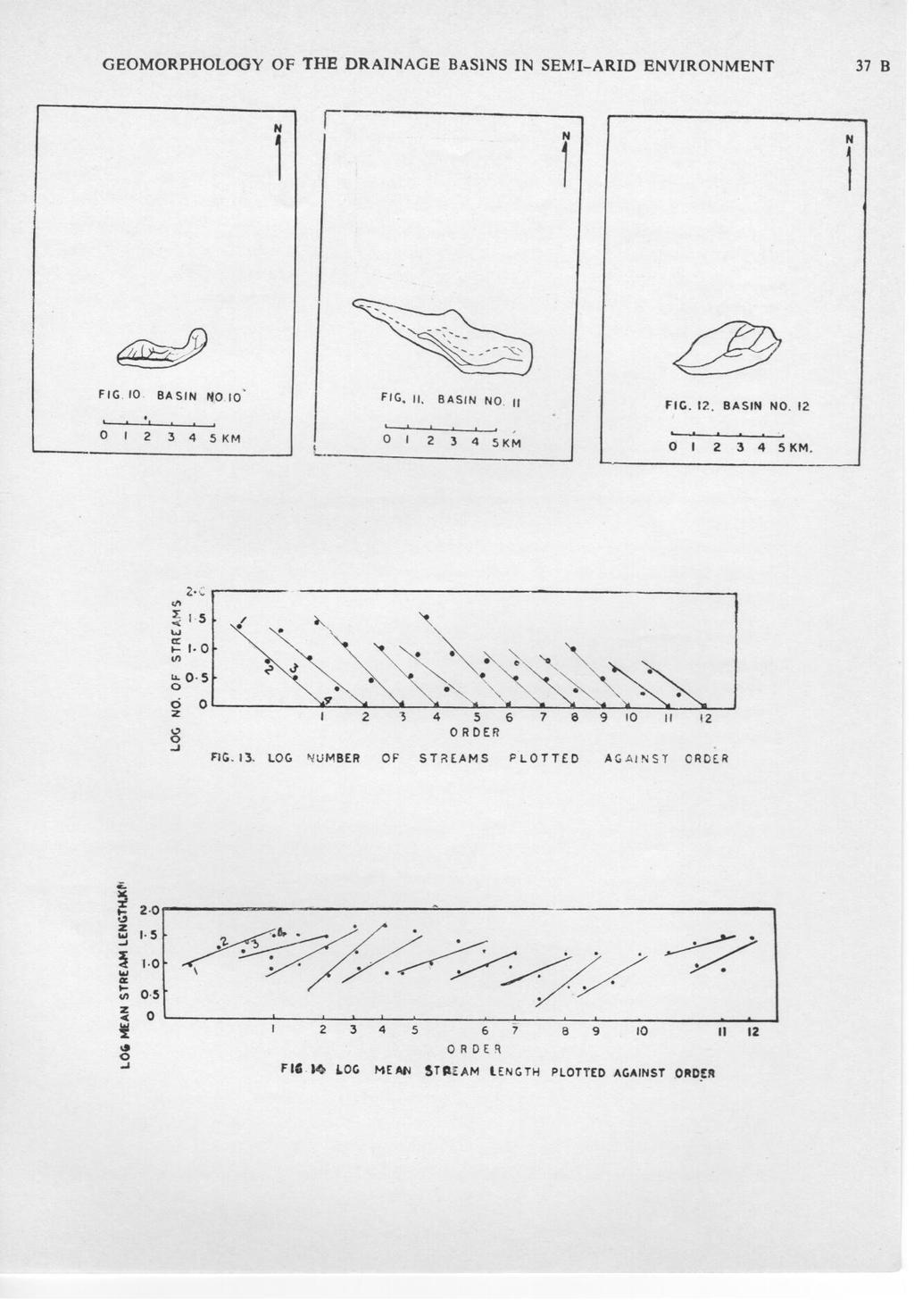
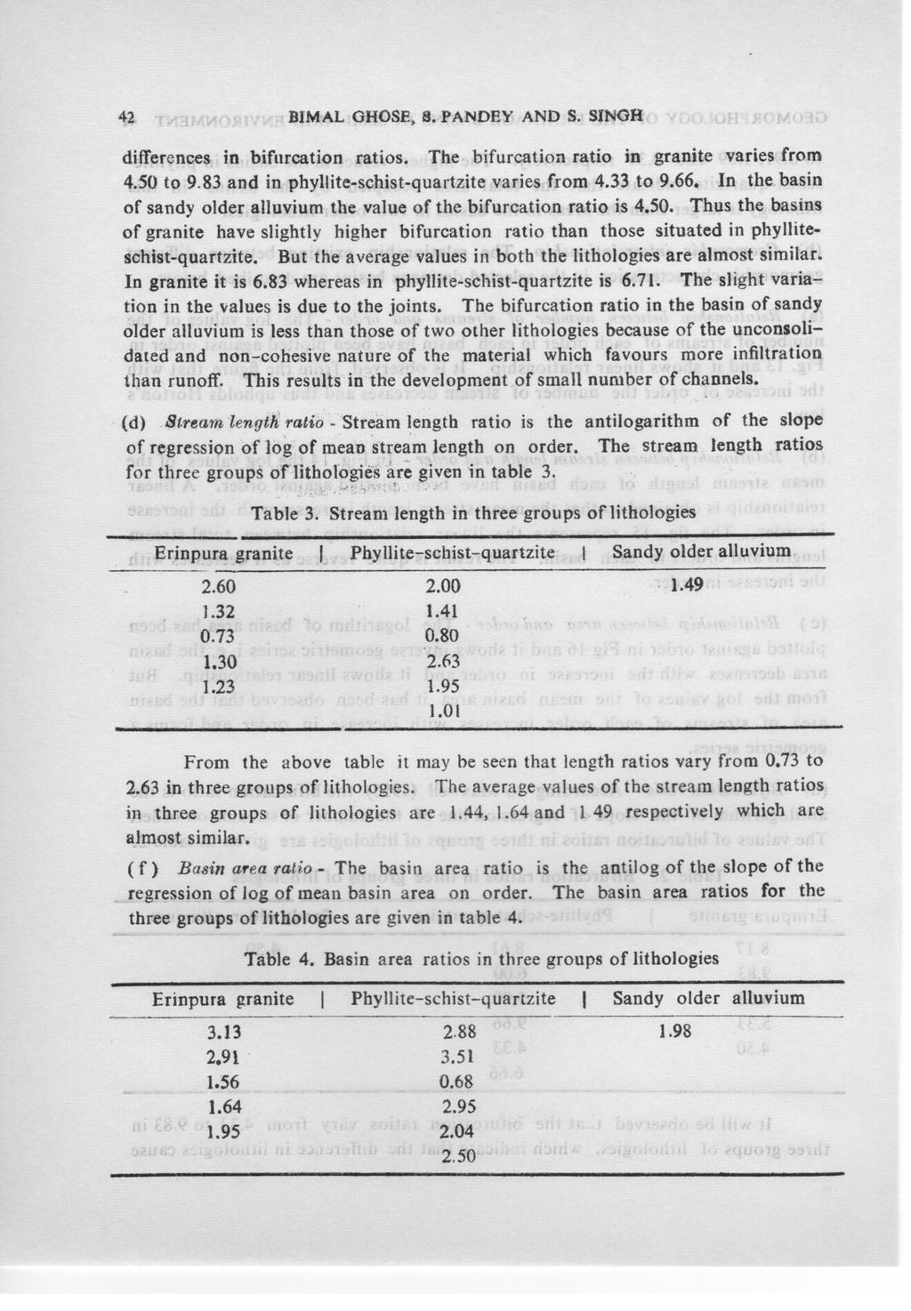
2 GEOMORPHOLOGY OF THE DRAINAGE BASINS IN SEMI-ARID ENVIRONMBNT 37 A N f N - fig. I. BASIN NO. I I Z 3 4 5K FIG.Z. ~ASIN NOZ... o I KM. FIG. 3. BASIN NO. I.". o I KM. N 'N {fi;j FIG.4. BASIN.NO '.,0 I KM FIG. 5 BASIN NOS..... o I' KM. FIG. 6. BASIN NO.6... o I KM. N " N f ~ '!G.T tasin NO 7. ~ I KM. "IG.B. BASIN NO.9... o I KM FIG 9. BASIN NO 9 (, ; KM
3

4 38 BIMAL GHOSE, S. PANDEY AND S. SINGH basin area have been plotted against each order and the regression lines have been fitted by least square method. The bifurcation ratios, streams length ratios and basin area ratios for each basin have also been calculated. RESULTS AND DISCUSSION (a) Geomorphic characteri,tic8 0/ streams in drainage basins- The quantitative characteristics of the streams for all the selected drainage basins under study have been given in the following table. Their salient features have also been described in detail. Table. Average geomorphic characteristics in three groups of lithologies Geomorphic characteris tics Number of streams Total stream length (kml Mean stream length (km) Largest length of the stream (km) Stream gradient Relief ratio Ma~imum basin length (km) Constant channel maintenance (sq. km) Drainage density (km per sq. km) Stream frequency Basin order Basin area (sq, km) Mean basin area (sq. km) Frequency of first order segment to total basin area Erinp.ura gradlte : ] ] I PhylIite:-schist -quartzite : ] Sandy older alluvium : ( i) Number of streams - The average number of streams in basins of granite is 22 whereas in the basins of phyliite-schist-quartzite and sandy older alluvium these are 2 and 8 respectively. It is obvious that the number of streams is dependant on the type of lithology. ( ii) Total, mean and longest length 0/ the.~tream8 - The average figures for the total stream lengths of the basins in granite, phyjiite-schist quartizite and sandy older alluvium are 24.78, and 6.09 km respectively. As in the granite there are larger number of streams along the joints and fissures than in phyllite-schistquartzite and sandy older alluvium, the total lengths of streams are more than
5
6
7

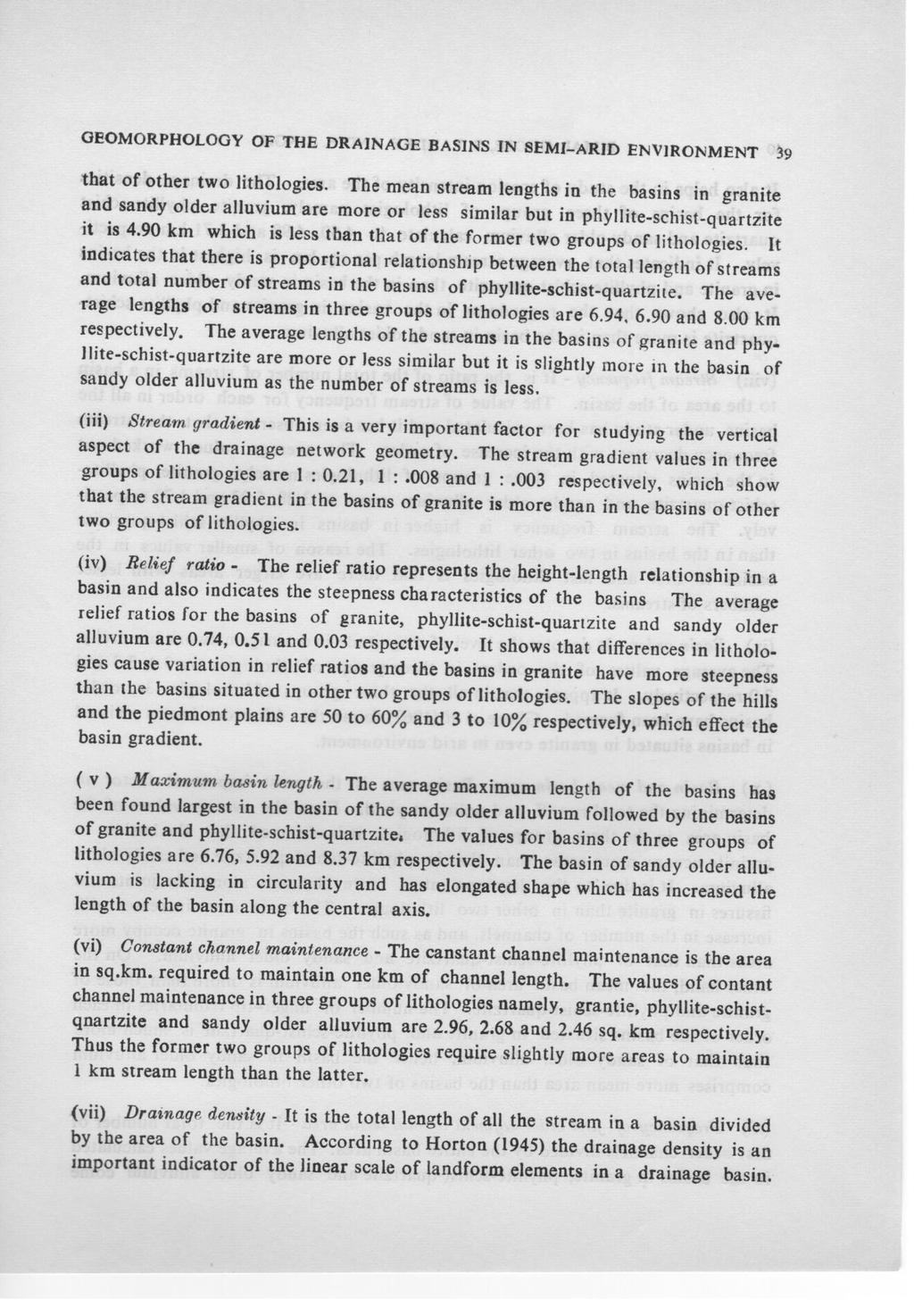
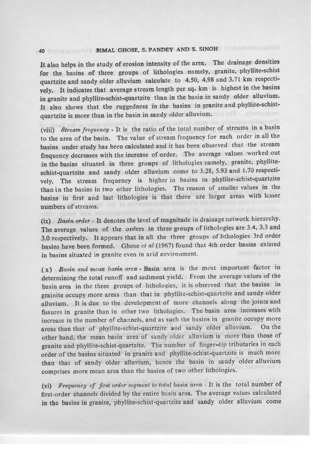
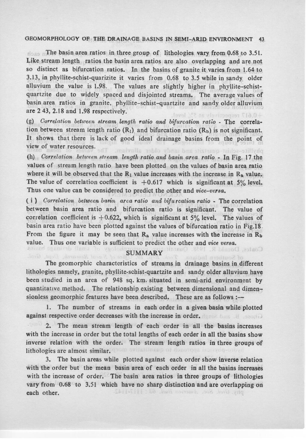
8 GEOMORPHOLOGY OF TH B DRAINAGE BASINS IN SBMI-ARID ENVIRONMENT 4 j 'i"o I- ~I S (oj...j L /-0 -< ~ 0 5 '"...J 0 ~ o l- Cl 9 FIG. IS. Loe; 2 J ORDER TOTAL STREAM LENGTH PLOTTEO 7 a AGAINST 9 OR DEft ~,~ ~_~ 0 5 o t OaDER 6 7 ~~I ~ 0::.J 9 0 II 2 I FIG. 6. LOG BASIN AREA PLOTTED AGAINST ORDER? o () &4 & ~'88 ~.9;.95 ;"3 ~ 5 FIG.I? BASIN AREA RATIO (Rb) ~2 5 I- -< "'2 0 ~ 5 a: -<, 0 z ~0'5 '" o FIG. 8. BIFURCATION RATIO (lib)
9
10

11 BIMAL GHOSE, S. PANDEY AND s. SINOH 4. The bifurcation ratios in three groups of lithologies vary from each other. The values in the basins in granite, phyllite-schist-quartzite and saudy older alluvium are 4.50 to 9.83, 4.33 to 9.66 and 4.50 respectively. 5. The relationship exist between bifurcation ratios and basin area ratios and also between basin area ratios and stream length ratios but there is no significant correlation between bifurcation ratios and stream length ratios. The correlation coefficient values for first two types of relationship are and respectively at 5% level. 6. The average values of basin order, basin area. number of streams, total stream length, relief ratio and contant of channel maintenance are varying in three groups of lithologies. The values are higher in granite followed by phyllite-schist-quartzite and sandy older alluvium. The values of mean basin area, mean stream length, longest length of the stream and maximum basin area are larger in sandy older alluvium while the values of drainage density, stream frequency and frequency of first order to total basin area are higher in phyllite schi st-quartzite. ACKNOWLEDGEMENT Authors are grateful to the Director and Head of the Divi~ion of Basic Resource Studies for providing facilities and valuable suggestions during the c9urse of study. Thanks are also due to Shri M. B. Jain, Statistician for necessary advice. REFERENCES Coates, Donald R Quantitative geomorphology of small drainage basins of Southern Indiana. Tech.. Rep. 0. Office of Naval Reaearch, Dept. Geol. Oolumbia University, New York. Chose, B. and Pandey, S Quantitative geomorphology of drainage basin. J. Ind. Soc. Soil. Sci. : Ghose, B., Pandey, S., Singh, S. and Ghees Lal Quantitative geomorphology of the drainage basins in the Central Luni basin in Western Rajasthan. Zeit. fur Geomorph. : 46-60, Ghose, B. and Singh, S Quick method of aerial photogrammetric mapping of geomorphic features, soils and vegetation community. Ind. J. Geog. : Horton, R. E Erosional development of streams and their drainage basins; hydro-physical approach to quantitative morphology. Geol. Soc. America Bull. 56 : Maxwell, J. C. 955; The bifurcation ratio in Horton's law of stream numbers (Abstract). Am. Geophys. Union Trans. 36 : 520. Strahler, A. N Hypsometric (area altitude) analysis of erosional topography. Geol. Soc. America Bull. 63: 7-42.
Figure 2.1: Constituent Area
 2 The Region 2.1 CONSTITUENT AREA The National Capital Region includes NCT-Delhi, nine districts of Haryana, six districts of Uttar Pradesh and one district of Rajasthan. Total area of the region is 34,144
CHAPTER V WATERSHED CHARACTERIZATION USING GIS
 61 CHAPTER V WATERSHED CHARACTERIZATION USING GIS 5.1 GENERAL: In this chapter, introduction to watershed characterization and analysis has been presented in the first part. Methodology to compute important
AN ANALYSIS OF THE LAWS OF DRAINAGE NET COMPOSITION
 AN ANALYSIS OF THE LAWS OF DRAINAGE NET COMPOSITION L.E. MILTON Australia M.S. submitted February 1965 ABSTRACT Two of the geomorphic Laws of Drainage Net Composition are discussed and it is shown that
MORPHOMETRIC ANALYSIS OF LAKSHMANTIRTHA RIVER BASIN AROUND HUNSUR TALUK, MYSORE, KARNATAKA, (INDIA)
") MORPHOMETRIC ANALYSIS OF LAKSHMANTIRTHA RIVER BASIN AROUND HUNSUR TALUK, MYSORE, KARNATAKA, (INDIA) Nilufer Arshad* and G.S. Gopalakrishna DOS in Geology University of Mysore, Mysore, (INDIA) Received
MORPHOMETRIC ANALYSIS OF LAKSHMANTIRTHA RIVER BASIN AROUND HUNSUR TALUK, MYSORE, KARNATAKA, (INDIA) Nilufer Arshad* and G.S. Gopalakrishna DOS in Geology University of Mysore, Mysore, (INDIA) Received
International Journal of Research (IJR) Vol-1, Issue-10 November 2014 ISSN
 Vol-1, Issue-10 November 2014 ISSN") Morphological Parameter Estimation Derived From ASTER-DEM Using GIS and Remote Sensing Techniques A Study on Hosakote Watershed of Dakshina Pinakini River Basin, Karnataka, India K. Satish 1* and H.C.
Morphological Parameter Estimation Derived From ASTER-DEM Using GIS and Remote Sensing Techniques A Study on Hosakote Watershed of Dakshina Pinakini River Basin, Karnataka, India K. Satish 1* and H.C.
Morphometric Analysis Of Bhogavati River Basin, Kolhapur District, Maharashtra, India.
 IOSR Journal of Mechanical and Civil Engineering (IOSR-JMCE) ISSN: 2278-1684, PP: 01-08 www.iosrjournals.org Morphometric Analysis Of Bhogavati River Basin, Kolhapur District, Maharashtra, India. P. A.
About the Author: E mail ID: Contact: proceedings. Page 1 of 8
 Catchment Delineation and Morphometric Analysis Using Geographical Information System of Naina Gorma Basin of Rewa District, M.P., India Vimala Singh 1, L.K. Sinha 2 Research Associate 1, DTRL, DRDO Scientist
INTERNATIONAL JOURNAL OF GEOMATICS AND GEOSCIENCES Volume 2, No 1, 2011
 INTERNATIONAL JOURNAL OF GEOMATICS AND GEOSCIENCES Volume 2, No 1, 2011 Copyright 2010 All rights reserved Integrated Publishing services Research article ISSN 0976 4380 Hypsometric Analysis of Varattaru
Morphometric Estimation of Parameters of Uttar Mand River Basin, Satara District, Maharashtra, India.
 Morphometric Estimation of Parameters of Uttar Mand River Basin, Satara District, Maharashtra, India. Mr.S.S.Chokakkar 1, Mr.G.N.ChavanPatil, Dr.D.N.Mudgal 3, Dr..Shreenivasa 4 1M.Sc., B.Ed, NET, PhD(Pur.)
INTERNATIONAL JOURNAL OF GEOMATICS AND GEOSCIENCES Volume 1, No 4, 2011
 Morphometric analysis of Nanjangud taluk, Mysore District, Karnataka, India, using GIS Techniques Mahadevaswamy.G 1, Nagaraju.D 1, Siddalingamurthy.S 1, Lakshmamma 1, Mohammad Subhan lone, Nagesh.P.C 2,
Chapter 5. Morphometric Control on Food
 Chapter 5 Morphometric Control on Food Key Words: Morphometry, Linear Morphometry, Areal Morphometry, Relief Morphometry, Morphometric Control and Flood 5.1 Morphometric Aspects Drainage basin or basins
Morphometric analysis of Kharlikani watershed in Odisha, India using spatial information technology Kishor Choudhari 1, Panigrahi B 2, Paul J.
 INTERNATIONAL JOURNAL OF GEOMATICS AND GEOSCIENCES Volume 4, No 4, 2014 Copyright 2010 All rights reserved Integrated Publishing services Research article ISSN 0976 4380 Morphometric analysis of Kharlikani
Influence of Terrain on Scaling Laws for River Networks
 Utah State University DigitalCommons@USU All Physics Faculty Publications Physics 11-1-2002 Influence of Terrain on Scaling Laws for River Networks D. A. Vasquez D. H. Smith Boyd F. Edwards Utah State
MORPHOMETRIC ANALYSIS OF ADYAR WATERSHED
 MORPHOMETRIC ANALYSIS OF ADYAR WATERSHED A.K.Bharadwaj 1,Pradeep.C 2,D.Thirumalaivasan 3,C.P.Shankar 4, N.Madhavan 5 1,2,3,4,5 Institute of Remote Sensing, Anna University, Guindy, Chennai, India- 600025.
A STUDY ON MORPHOMETRIC PARAMETER OF A WATERSHED FOR SUSTAINABLE WATER CONSERVATION
 International Journal of Civil Engineering and Technology (IJCIET) Volume 8, Issue 9, September 2017, pp. 271 278, Article ID: IJCIET_08_09_031 Available online at http://http://www.iaeme.com/ijciet/issues.asp?jtype=ijciet&vtype=8&itype=9
A Case Study: Morphometric Characteristics of Sub-Watershed (P- 17) in Paras Region, Akola District, Maharashtra, India using Remote Sensing & GIS
 in Paras Region, Akola District, Maharashtra, India using Remote Sensing & GIS") Cloud Publications International Journal of Advanced Earth Science and Engineering 2017, Volume 6, Issue 1, pp. 492 499 ISSN: 2320 3609, Crossref: 10.23953/cloud.ijaese.236 Case Study Open Access A Case
Cloud Publications International Journal of Advanced Earth Science and Engineering 2017, Volume 6, Issue 1, pp. 492 499 ISSN: 2320 3609, Crossref: 10.23953/cloud.ijaese.236 Case Study Open Access A Case
Gis Based On Morphometric Analysis of Part of Manair River Basin in Karimnagar District, Telangana State.
 IOSR Journal of Applied Geology and Geophysics (IOSR-JAGG) e-issn: 0990, p-issn: 098.Volume, Issue Ver. II (Sep. Oct. 07), PP 0-07 www.iosrjournals.org Gis Based On Morphometric Analysis of Part of Manair
ENGINEERING EXPERIMENT STATION IOWA STATE UNIVERSITY, AMES, IOWA. by FIORE J L I, MORPHOMETRIC COMPARISON OF
 STECHNICAL REPORT 1 MORPHOMETRIC COMPARISON OF HAYDEN PRAIRIE AND ADJACENT CULTIVATED AREA by FIORE 902@6 Keith W. Anderson, Graduate Assistant R. A. Lohnes, Assistant Professor of Civil Engineering (Distribution
Chapter 1 Quantitative Analysis of Geomorphometric Parameters of Wadi Kerak, Jordan, Using Remote Sensing and GIS
 Chapter 1 Quantitative Analysis of Geomorphometric Parameters of Wadi Kerak, Jordan, Using Remote Sensing and GIS Yahya Farhan, Ali Anbar, Omar Enaba, Nisrin Al-Shaikh Geomorphometric analysis was carried
MOUNTAIN ORDERING: A METHOD FOR CLASSIFYING MOUNTAINS BASED ON THEIR MORPHOMETRY
 Earth Surface Processes and Landforms Earth Surf. Process. Landforms 24, 653±660 (1999) MOUNTAIN ORDERING: A METHOD FOR CLASSIFYING MOUNTAINS BASED ON THEIR MORPHOMETRY SHUJI YAMADA Department of Geography,
OBJECTIVES. Fluvial Geomorphology? STREAM CLASSIFICATION & RIVER ASSESSMENT
 STREAM CLASSIFICATION & RIVER ASSESSMENT Greg Babbit Graduate Research Assistant Dept. Forestry, Wildlife & Fisheries Seneca Creek, Monongahela National Forest, West Virginia OBJECTIVES Introduce basic
MORPHOMETRIC ANALYSIS OF RAJGARDH WATERSHED OF MADHYA PRADESH
 International Journal of Civil Engineering and Technology (IJCIET) Volume 8, Issue 4, April 2017, pp. 1319 1328 Article ID: IJCIET_08_04_149 Available online at http://www.iaeme.com/ijciet/issues.asp?jtypeijciet&vtype8&itype4
Morphometric Analysis for Hard Rock Terrain of Upper Ponnaiyar Watershed, Tamilnadu A GIS Approach
 International Journal of Research Studies in Science, Engineering and Technology Volume 1, Issue 9, December 2014, PP 205-209 ISSN 2349-4751 (Print) & ISSN 2349-476X (Online) Morphometric Analysis for
MORPHOMETRY OF BUGGAVANKA WATERSHED IN KADAPA, ANDHRA PRADESH, INDIA USING SPATIAL INFORMATION TECHNOLOGY
 BEST: International Journal of Humanities, Arts, Medicine and Sciences (BEST: IJHAMS) ISSN 2348-0521 Vol. 3, Issue 2, Feb 2015, 1-8 BEST Journals MORPHOMETRY OF BUGGAVANKA WATERSHED IN KADAPA, ANDHRA PRADESH,
Morphotectonic and Lineament analysis from Bhatia and Jaigarh Creek, Ratnagiri, MS, India: Neotectonic Implication
 International Research Journal of Earth Sciences ISSN 2321 2527 Int. Res.J. Earth Sci. Morphotectonic and Lineament analysis from Bhatia and Jaigarh Creek, Ratnagiri, MS, India: Neotectonic Implication
ESTIMATION OF MORPHOMETRIC PARAMETERS AND RUNOFF USING RS & GIS TECHNIQUES
 ESTIMATION OF MORPHOMETRIC PARAMETERS AND RUNOFF USING RS & GIS TECHNIQUES Shrudha. V. K¹, Hafeezunnisa² 1 Assistant Professor, Rajarajeshwari College of Engineering Bangalore 2 Assistant Engineer, WRDO
DRAINAGE BASIN MORPHOLOGY. Morphometric analysis is defined as the numerical
 C H A P T E R 3 DRAINAGE BASIN MORPHOLOGY 3.1 Introduction Morphometric analysis is defined as the numerical systematization of landform elements measured from topographic maps and provides real basis
Civil Engineering Journal
 Available online at www.civilejournal.org Civil Engineering Journal Vol. 1, No. 2, December, 2015 Comparative Study of Landsat and Aster Data by Morphometric Analysis Sujit Kumar a*, Tapasi Bhandary b
Chapter IV MORPHOMETRIC ANALYSIS AND STREAM NETWORK CHARACTERISTICS IN GADAG DISTRICT
 Chapter IV MORPHOMETRIC ANALYSIS AND STREAM NETWORK CHARACTERISTICS IN GADAG DISTRICT 4.1 INTRODUCTION: Streams and rivers are the most dynamic parts of the earth s physical environment. The behavior of
C=l R 1/6 1/6 C=33. (ii) Annals of Arid Zone 24(5) (1985) .,,- MANNING'S COEFFICIENT OF ROUGHNESS FOR RIVERS OF
 Annals of Arid Zone 24(5) (1985) .,,- MANNING'S COEFFICIENT OF ROUGHNESS FOR RIVERS OF") Annals of Arid Zone 24(5) 258262 (1985) MANNING' COFFICINT OF ROUGHN FOR RIVR OF.,, WTRN RAJATHAN N.. Vangani and A. K. Raila Central Arid Zone Research Institute, Jodhpur342 3 The discharge measurements
Annals of Arid Zone 24(5) 258262 (1985) MANNING' COFFICINT OF ROUGHN FOR RIVR OF.,, WTRN RAJATHAN N.. Vangani and A. K. Raila Central Arid Zone Research Institute, Jodhpur342 3 The discharge measurements
MORPHOMETRIC ANALYSIS OF KOSI RIVER SUB WATERSHED IN RAMNAGAR, UTTARAKHAND USING GIS AND REMOTE SENSING TECHNIQUES
 MORPHOMETRIC ANALYSIS OF KOSI RIVER SUB WATERSHED IN RAMNAGAR, UTTARAKHAND USING GIS AND REMOTE SENSING TECHNIQUES Saif Said Associate Professor, Civil Engineering Department, Aligarh Muslim University,
CHAPTER 9 SUMMARY AND CONCLUSIONS
 CHAPTER 9 SUMMARY AND CONCLUSIONS The following are the important conclusions and salient features of the present study. 1. The evaluation of groundwater potential is a prerequisite for any kind of planning
Morphometric Analysis of Jiya Dhol River Basin
 Morphometric Analysis of Jiya Dhol River Basin Luna Moin Das North-Eastern Hill University, Shillong Abstract: Basin morphometry is an important means of understanding a drainage basin using mathematically
Each basin is surrounded & defined by a drainage divide (high point from which water flows away) Channel initiation
 Channel initiation") DRAINAGE BASINS A drainage basin or watershed is defined from a downstream point, working upstream, to include all of the hillslope & channel areas which drain to that point Each basin is surrounded &
DRAINAGE BASINS A drainage basin or watershed is defined from a downstream point, working upstream, to include all of the hillslope & channel areas which drain to that point Each basin is surrounded &
, Horton , km Tsinghua Tongfang Optical Disc Co., Ltd. All rights reserved. Vol. 21, No. 2 GEO GRAPHICAL RESEARCH
 21 2 2002 3 Vol. 21, No. 2 GEO GRAPHICAL RESEARCH Mar., 2002 : 100020585 (2002) 0220171208 (, 100101) :, 50 500 2500, 6 15,,,,,, : ; ; : P93111 ; P33314 : A, [1, Horton 1942 ], [2 10, ],,,,,,,,,,,,,, 50
Prioritization of sub-watersheds in semi arid region, Western Maharashtra, India using Geographical Information System
 American Journal of Engineering Research (AJER) e-issn : 2320-0847 p-issn : 2320-0936 Volume-02, Issue-10, pp-128-135 www.ajer.org Research Paper Open Access Prioritization of sub-watersheds in semi arid
SPECTRAL DISCRIMINATION OF ROCK TYPES IN THE ARAVALLI MOUNTAIN RANGES OF RAJASTHAN (INDIA) USING LANDSAT THEMATIC MAPPER DATA
 USING LANDSAT THEMATIC MAPPER DATA") SPECTRAL DISCRIMINATION OF ROCK TYPES IN THE ARAVALLI MOUNTAIN RANGES OF RAJASTHAN (INDIA) USING LANDSAT THEMATIC MAPPER DATA Dr. Nilanchal Patel Reader, Department of Remote Sensing Birla Institute of
SPECTRAL DISCRIMINATION OF ROCK TYPES IN THE ARAVALLI MOUNTAIN RANGES OF RAJASTHAN (INDIA) USING LANDSAT THEMATIC MAPPER DATA Dr. Nilanchal Patel Reader, Department of Remote Sensing Birla Institute of
Morphometric Analysis of Shaliganga Sub Catchment, Kashmir Valley, India Using Geographical Information System
 Morphometric Analysis of Shaliganga Sub Catchment, Kashmir Valley, India Using Geographical Information System Mohd Iqbal 1, Haroon Sajjad 1, F.A. Bhat 2 1 Department of Geography, Faculty of Natural Sciences,
Morphometric Analysis of a Watershed Using Remote Sensing and GIS - A Case Study
 Jour. Agric. Physics, Vol. 2, No.1, pp. 52-56 (22) Morphometric Analysis of a Watershed Using Remote Sensing and GIS - A Case Study DEBASHIS CHAKRABORTY, DIBYENDU DUTTN AND H. CHANDRASEKHARAN# Division
Morphometric Analysis for Evaluating Groundwater Potential Zones, In Kusangai Jor Watershed Area, Dist. Bolangir, Orissa.
 Morphometric Analysis for Evaluating Groundwater Potential Zones, In Kusangai Jor Watershed Area, Dist. Bolangir, Orissa. Alokesh Chatterjee 1, Asish Tantubay 1 1 Department of Geology, Presidency College,
LANDSAT-TM IMAGES IN GEOLOGICAL MAPPING OF SURNAYA GAD AREA, DADELDHURA DISTRICT WEST NEPAL
 LANDSAT-TM IMAGES IN GEOLOGICAL MAPPING OF SURNAYA GAD AREA, DADELDHURA DISTRICT WEST NEPAL L. N. Rimal* A. K. Duvadi* S. P. Manandhar* *Department of Mines and Geology Lainchaur, Kathmandu, Nepal E-mail:
[Penumaka, 7(1): January-March 2017] ISSN Impact Factor
![[Penumaka, 7(1): January-March 2017] ISSN Impact Factor](/thumbs/95/124653515.jpg "[Penumaka, 7(1): January-March 2017] ISSN Impact Factor") INTERNATIONAL JOURNAL OF ENGINEERING SCIENCES &MANAGEMENT HYDROGEOMORPHOLOGY OF CHEVELLA BASIN, RANGA REDDY DISTRICT, TELANGANA STATE Penumaka Ramesh* 1 & Podila Sankara Pitchaiah 2 * 1&2 Department of
INTERNATIONAL JOURNAL OF ENGINEERING SCIENCES &MANAGEMENT HYDROGEOMORPHOLOGY OF CHEVELLA BASIN, RANGA REDDY DISTRICT, TELANGANA STATE Penumaka Ramesh* 1 & Podila Sankara Pitchaiah 2 * 1&2 Department of
SPACING OF RURAL SETTLEMENTS IN NAGAUR DISTRICT, RAJASTHAN: A SPATIAL ANALYSIS
 Journal of Global Resources Volume 5 July 2017 Page 28-33 ISSN: 2395-3160 (Print), 2455-2445 (Online) 05 SPACING OF RURAL SETTLEMENTS IN NAGAUR DISTRICT, RAJASTHAN: A SPATIAL ANALYSIS Varun Binda Assistant
CHAPTER 4 THE INFLUENCE OF RIVER BASIN MORPHOLOGY ON RIVER GROUNDWATER INTERACTION
 CHAPTER 4 THE INFLUENCE OF RIVER BASIN MORPHOLOGY ON RIVER GROUNDWATER INTERACTION CHAPTER 4 THE INFLUENCE OF RIVER BASIN MORPHOLOGY ON RIVER-GROUNDWATER INTERACTION 4.0. INTRODUCTION The relationship
FOREST RESEARCH INSTITUTE, DEHRADUN
 PROJECT REPORT DRAINAGE AND REPLENISHMENT STUDY OF MINED AREA OF GANGA SHYAMPUR RIVER HARIDWAR Submitted to UTTARAKHAND FOREST DEVELOPMENT CORPORATION (UFDC) 73, Nehru Road, Deharadun Prepared&Submitted
MORPHOMETRIC ANALYSIS OF WATERSHEDS IN THE KUNIGAL AREA OF TUMKUR DISTRICT, SOUTH INDIA USING REMOTE SENSING AND GIS TECHNOLOGY
 MORPHOMETRIC ANALYSIS OF WATERSHEDS IN THE KUNIGAL AREA OF TUMKUR DISTRICT, SOUTH INDIA USING REMOTE SENSING AND GIS TECHNOLOGY PROJECT REFERENCE NO. : 37S1170 COLLEGE : SIDDAGANGA INSTITUTE OF TECHNOLOGY,
Keywords: Morphometry, Upper river basin, Remote sensing GIS, spatial information technology
 A STUDY OF MORPHOMETRIC ANALYSIS USING REMOTE SENSING TECHNIQUES OF UPPER NIRA DRAINAGE BASIN, MAHARASHTRA Anuradha Ohal Dept. of Geography Tilak Maharashtra Vidyapeeth, Pune ABSTRACT Nira is tributary
International Journal of Advancements in Research & Technology, Volume 2, Issue 5, M ay ISSN
 International Journal of Advancements in Research & Technology, Volume 2, Issue 5, M ay-2013 301 Estimation of groundwater prospectus zone mapping and morphometric analysis of WRD-4 watershed in Wardha
The subject paper is being submitted for approval for publication in the annual volume entitled Geological Survey Research.
 Water Resources Division 345 Middlefield Road Menlo Park, California January 12, 1965 Memorandum To: Mr. Frank E. Clark, Chief, General Hydrology Branch Thru: Area Hydrologist PCA From: Valmore C. LaMarche
MAPPING OF HGM ENVIRONMENT USING SATELITE DATA A case study of Block Datia, Madhya Pradesh (INDIA)
") MAPPING OF HGM ENVIRONMENT USING SATELITE DATA A case study of Block Datia, Madhya Pradesh (INDIA) Satish K. Chakravarty* and D.R. Tiwari Department of Geology, Govt. M.V.M Bhopal (INDIA) Received June
MAPPING OF HGM ENVIRONMENT USING SATELITE DATA A case study of Block Datia, Madhya Pradesh (INDIA) Satish K. Chakravarty* and D.R. Tiwari Department of Geology, Govt. M.V.M Bhopal (INDIA) Received June
Evaluation of Morphometric parameters of drainage networks derived from Topographic Map and Digital Elevation Model using Remote Sensing and GIS
 INTERNATIONAL JOURNAL OF GEOMATICS AND GEOSCIENCES Volume 5, No 4, 2015 Copyright by the authors - Licensee IPA- Under Creative Commons license 3.0 Research article ISSN 0976 4380 Evaluation of Morphometric
Simplify Equation to Calculate Elongation River Basin Proposed by Schumm (1956)
") Simplify Equation to Calculate Elongation River Basin Proposed by Schumm (1956) Dr. Saad.A.Mubark.aldarraji.Assisent Professor. Department of Geography. Faculty of Education.Ibn Rushed. Baghdad University.
Simplify Equation to Calculate Elongation River Basin Proposed by Schumm (1956) Dr. Saad.A.Mubark.aldarraji.Assisent Professor. Department of Geography. Faculty of Education.Ibn Rushed. Baghdad University.
Chapter 4 : Morphometric Analysis
 Chapter : Morphometric Analysis. Introduction Geology, geomorphology, structure and drainage patterns especially in hard rock terrains are the primary determinants of river ecosystem functioning at the
University Grants Commission, New Delhi Recognized Journal No ISSN: Print: ISSN: Online: X
 Morphometric Analysis of Lower Bhavani River Basin, Using Geographical Information System Ipsita Pradhan 1, Dr S.Vasudevan 2, R. Selvaganapathi 3, G. Sathiyamoorthy 4, Subhrajit Das 5 1,3,4,5 Ph.D. Research
Morphometric Analysis of Sonbhadra Sub- Watershed of Tawa Reservoir Catchment Area of Hoshangabad District, Madhya Pradesh using GIS Techniques
 IJIRST International Journal for Innovative Research in Science & Technology Volume 2 Issue 07 December 2015 ISSN (online): 2349-6010 Morphometric Analysis of Sonbhadra Sub- Watershed of Tawa Reservoir
SUITABILITY OF ELECTRICAL RESISTIVITY SURVEY FOR SELECTING ANICUT SITE IN ORDER TO AUGMENT GROUND WATER A CASE STUDY
 Annals of Arid Zone 30 (3) : 187-195, 1991 SUTABLTY OF ELECTRCAL RESSTVTY SURVEY FOR SELECTNG ANCUT STE N ORDER TO AUGMENT GROUND WATER A CASE STUDY J.P. SHUKLA* and S.M. PANDEY Ground Water Department,
PRIORITIZATION BASED ON MORPHOMETRIC ANALYSIS OF DUDHGANGA CATCHMENT,KASHMIR VALLEY, INDIA. USING REMOTE SENSING & GEOGRAPHIC INFORMATION SYSTEM.
 ISSN: 2307-6992 Available Online: http://ajgr.rstpublishers.com/ PRIORITIZATION BASED ON MORPHOMETRIC ANALYSIS OF DUDHGANGA CATCHMENT,KASHMIR VALLEY, INDIA. USING REMOTE SENSING & GEOGRAPHIC INFORMATION
Report for Area Drainage Studies for 1320 MW (2x660 MW) THERMAL POWER PROJECT AT MIRZAPUR, U.P.
 THERMAL POWER PROJECT AT MIRZAPUR, U.P.") Report for Area Drainage Studies for 1320 MW (2x660 MW) THERMAL POWER PROJECT AT MIRZAPUR, U.P. 1. Introduction M/s Welspun Energy Uttar Pradesh Ltd. (WEUPL) is putting up 1320 MW (2 x 660 MW) coal fired
Report for Area Drainage Studies for 1320 MW (2x660 MW) THERMAL POWER PROJECT AT MIRZAPUR, U.P. 1. Introduction M/s Welspun Energy Uttar Pradesh Ltd. (WEUPL) is putting up 1320 MW (2 x 660 MW) coal fired
OBSERVATIONS AND ANALYSIS ON RAINFALL INDUCED SLOPE FAILURES FOR JELAPANG AND GUA TEMPURUNG AREA USING G.I.S.
 PRESENTATION TO THE BOARD OF DIRECTORS PLUS BERHAD OBSERVATIONS AND ANALYSIS ON RAINFALL INDUCED SLOPE FAILURES FOR JELAPANG AND GUA TEMPURUNG AREA USING G.I.S. MAY 2015 TABLE OF CONTENTS Introduction:
GIS based quantitative morphometric analysis and its consequences: a case study from Shanur River Basin, Maharashtra India
 Appl Water Sci (2017) 7:861 871 DOI 10.1007/s13201-015-0298-7 ORIGINAL ARTICLE GIS based quantitative morphometric analysis and its consequences: a case study from Shanur River Basin, Maharashtra India
Geomorphological Analysis of Aralamallige Watershed, Bangalore Using Remote Sensing and GIS Approach
 International Journal of Research Studies in Biosciences (IJRSB) Volume 2, Issue 1, February 2014, PP 6-10 www.arcjournals.org Geomorphological Analysis of Aralamallige Watershed, Bangalore Using Remote
MORPHOMETRIC ANALYSIS OF TURSIQ BASIN EAST OF IRAQ USING REMOTE SENSING AND GIS TECHNIQUES
 MORPHOMETRIC ANALYSIS OF TURSIQ BASIN EAST OF IRAQ USING REMOTE SENSING AND GIS TECHNIQUES Mutasim Ibrahim. Malik, Sarteel Hamid AL-Shammary, Sajad Abudlkadhem AL-yasry Waist University, College of Science,
INTERNATIONAL JOURNAL OF APPLIED RESEARCH IN ENGINEERING AND TECHNOLOGY
 Research Article ISSN: 2319-507X INTERNATIONAL JOURNAL OF PURE AND APPLIED RESEARCH IN ENGINEERING AND TECHNOLOGY A PATH FOR HORIZING YOUR INNOVATIVE WORK MORPHOMETRIC AND HYDROGEOMORPHIC ANALYSIS OF PILI
MORPHOMETRIC CHARACTERISATION OF GAGAR WATERSHED IN KUMAONREGIONOFUTT ARAKHAND FOR MANAGEMENT PLANNING: A GIS APPROACH
 gric. Sci. Digest., 34 (3) : 163-170, 2014 doi:10.5958/0976-0547.2014.00995.1 GRICUTUR RESERCH COMMUNICTION CENTRE www.arccjournals.com MORPHOMETRIC CHRCTERISTION OF GGR WTERSHED IN KUMONREGIONOFUTT RKHND
Landforms. Why does the land look like it does? 1. Controlled by water 2. Controlled by the rocks
 Landforms Why does the land look like it does? 1. Controlled by water 2. Controlled by the rocks Landforms Made by Running Water Stream erosion The evolution of a river system Entrenched meanders Fluvial
Vol.3,No.3,September2017
 Vol.3,No.3,September2017 Int. J. of Geol. & Earth Sci., 2017 Abiodun O Adebola et al., 2017 Research Paper ISSN 2395-647X www.ijges.com Vol. 3, No. 3, September 2017 2017 IJGES. All Rights Reserved MORPHOMETRIC
Prashant P. Magar 1 and Nirupama P. Magar 2 1
 Journal of Indian Geomorphology Volume 4, 2016 ISSN 2320-0731 Indian Institute of Geomorphologists (IGI) Application of Hack s Stream Gradient Index (SL Index) to Longitudinal Profiles of the Rivers Flowing
Grouping of Geomorphic Parameters in Selected Watershed Component Analysis for Hydrological Modelling
 International Research Journal of Environment Sciences E-ISSN 2319 1414 Grouping of Geomorphic Parameters in Selected Watershed using Principal Component Analysis for Hydrological Modelling Abstract B.K.
Lab 2: Slope Aspect Lab
 Lab : Slope Aspect Lab Objectives: to investigate potential differences between north- and south-facing slopes in the foothills of the Colorado Front Range to become familiar with the US Geological Survey
INTERNATIONAL JOURNAL OF ENVIRONMENTAL SCIENCES Volume 3, No 1, Copyright by the authors - Licensee IPA- Under Creative Commons license 3.
 INTERNATIONAL JOURNAL OF ENVIRONMENTAL SCIENCES Volume 3, No 1, 2012 Copyright by the authors - Licensee IPA- Under Creative Commons license 3.0 Review article ISSN 0976 4402 Morphometric analysis and
2. PHYSICAL FEATURES OF INDIA
 2. PHYSICAL FEATURES OF INDIA Question 1: Choose the right answer from the four alternatives given below. (i) A landmass bound by sea on three sides is referred to as (a) Coast (c) Peninsula (b) Island
SOIL INFORMATION FOR PUMPED WATER STORAGE SCHEME, STEELPOORT VALLEY
 REPORT On contract research for Bohlweki Environmental SOIL INFORMATION FOR PUMPED WATER STORAGE SCHEME, STEELPOORT VALLEY February 2007 By D.G. Paterson ARC-Institute for Soil, Climate and Water, Private
Morphometric Analysis of Didessa River Catchment in Blue Nile Basin, Western Ethiopia
 DOI: http://dx.doi.org/10.4314/star.v3i3.31 ISSN: 2226-7522(Print) and 2305-3372 (Online) Science, Technology and Arts Research Journal Sci. Technol. Arts Res. J., July-Sep 2014, 3(3): 191-197 Journal
GIS Based Delineation of Micro-watershed and its Applications: Mahendergarh District, Haryana
 Kamla-Raj 2012 J Hum Ecol, 38(2): 155-164 (2012) GIS Based Delineation of Micro-watershed and its Applications: Mahendergarh District, Haryana Gulshan Mehra and Rajeshwari * Department of Geography, Kurukshetra
Morphometric Analysis of Chamundi Hills, Mysuru, India Using Geographical Information System
 Volume-7, Issue-1, January-February 2017 International Journal of Engineering and Management Research Page Number: 279-283 Morphometric Analysis of s, Mysuru, India Using Geographical Information System
DROUGHT RISK EVALUATION USING REMOTE SENSING AND GIS : A CASE STUDY IN LOP BURI PROVINCE
 DROUGHT RISK EVALUATION USING REMOTE SENSING AND GIS : A CASE STUDY IN LOP BURI PROVINCE K. Prathumchai, Kiyoshi Honda, Kaew Nualchawee Asian Centre for Research on Remote Sensing STAR Program, Asian Institute
Geography Class XI Fundamentals of Physical Geography Section A Total Periods : 140 Total Marks : 70. Periods Topic Subject Matter Geographical Skills
 Geography Class XI Fundamentals of Physical Geography Section A Total Periods : 140 Total Marks : 70 Sr. No. 01 Periods Topic Subject Matter Geographical Skills Nature and Scope Definition, nature, i)
Prioritization of Sub Watersheds using Morphometric Analysis: A Remote Sensing and GIS Perspective
 Prioritization of Sub Watersheds using Morphometric Analysis: A Remote Sensing and GIS Perspective Love Kumar 1, D. Khalkho* 2, P. Katre 3, G. K. Nigam 4 Ph.D. Scholar, SVCAET & RS, FAE, IGKV, Raipur,
Geographical Information System Based Morphometric Analysis of Halia Drainage Area, Nalgonda District, Andhra Pradesh, India
 Geographical Information System Based Morphometric Analysis of Halia Drainage Area, Nalgonda District, Andhra Pradesh, India Sarala.C Associate Professor, Centre for Water Resources, Institute of Science
Physical Geology Horton s Laws
 Physical Geology Horton s Laws Name PLAYFAIR S LAW (1802) Every river appears to consist of a main trunk, fed from a variety of branches, each running in a valley proportioned to its size, and all of them
CHAPTER 1. Geo Challenges 1A to 1D. & World Map Activity
 CHAPTER 1 Geo Challenges 1A to 1D & World Map Activity SELECT YOUR CHALLENGE World Map Activity Challenge 1A Challenge 1B Challenge 1C Challenge 1D Challenge 1A WS PG. 2 STEP #1 Label the largest continent
mountain rivers fixed channel boundaries (bedrock banks and bed) high transport capacity low storage input output
 high transport capacity low storage input output") mountain rivers fixed channel boundaries (bedrock banks and bed) high transport capacity low storage input output strong interaction between streams & hillslopes Sediment Budgets for Mountain Rivers Little
mountain rivers fixed channel boundaries (bedrock banks and bed) high transport capacity low storage input output strong interaction between streams & hillslopes Sediment Budgets for Mountain Rivers Little
Morphometric Analysis of Gostani River Basin in Andhra Pradesh State, India Using Spatial Information Technology
 Morphometric Analysis of Gostani River Basin in Andhra Pradesh State, India Using Spatial Information Technology Nageswara Rao.K 1,Swarna Latha.P 2, Arun Kumar.P 3,Hari Krishna.M 2 1 Department of Civil
Basin characteristics
 Basin characteristics From hydrological processes at the point scale to hydrological processes throughout the space continuum: point scale à river basin The watershed characteristics (shape, length, topography,
INTERNATIONAL JOURNAL OF GEOMATICS AND GEOSCIENCES Volume 2, No 2, 2011
 INTERNATIONAL JOURNAL OF GEOMATICS AND GEOSCIENCES Volume 2, No 2, 2011 Copyright 2010 All rights reserved Integrated Publishing services Research article ISSN 0976 4380 Prioritization of miniwatersheds
Earth Science. STREAM DRAINAGE PATTERNS (start by reading the first page of these notes!)
") Name _ Earth Science STREAM DRAINAGE PATTERNS (start by reading the first page of these notes!) WHAT IS A DRAINAGE PATTERN? Streams seek the lowest path as they move downhill, and they tend to erode their
Name _ Earth Science STREAM DRAINAGE PATTERNS (start by reading the first page of these notes!) WHAT IS A DRAINAGE PATTERN? Streams seek the lowest path as they move downhill, and they tend to erode their
ASTER DEM Based Studies for Geological and Geomorphological Investigation in and around Gola block, Ramgarh District, Jharkhand, India
 International Journal of Scientific & Engineering Research, Volume 3, Issue 2, February-2012 1 ASTER DEM Based Studies for Geological and Geomorphological Investigation in and around Gola block, Ramgarh
Laboratory Exercise #4 Geologic Surface Processes in Dry Lands
 Page - 1 Laboratory Exercise #4 Geologic Surface Processes in Dry Lands Section A Overview of Lands with Dry Climates The definition of a dry climate is tied to an understanding of the hydrologic cycle
Laboratory Exercise #3 The Hydrologic Cycle and Running Water Processes
 Laboratory Exercise #3 The Hydrologic Cycle and Running Water Processes page - 1 Section A - The Hydrologic Cycle Figure 1 illustrates the hydrologic cycle which quantifies how water is cycled throughout
International Journal of Modern Trends in Engineering and Research e-issn No.: , Date: April, 2016
 International Journal of Modern Trends in Engineering and Research www.ijmter.com e-issn No.:2349-9745, Date: 28-30 April, 2016 Landslide Hazard Management Maps for Settlements in Yelwandi River Basin,
Floodplain modeling. Ovidius University of Constanta (P4) Romania & Technological Educational Institute of Serres, Greece
 Romania & Technological Educational Institute of Serres, Greece") Floodplain modeling Ovidius University of Constanta (P4) Romania & Technological Educational Institute of Serres, Greece Scientific Staff: Dr Carmen Maftei, Professor, Civil Engineering Dept. Dr Konstantinos
Floodplain modeling Ovidius University of Constanta (P4) Romania & Technological Educational Institute of Serres, Greece Scientific Staff: Dr Carmen Maftei, Professor, Civil Engineering Dept. Dr Konstantinos
MORPHOLOGICAL PARAMETER ESTIMATION DERIVED FROM TOPOSHEETS AND ASTER DEM A STUDY ON WATERSHEDS OF DAKSHINA PINAKINI RIVER BASIN IN KARNATAKA, INDIA
 International Journal of Applied and Natural Sciences (IJANS) ISSN 2319-4014 Vol. 2, Issue 4, Sep 2013, 125-134 IASET MORPHOLOGICAL PARAMETER ESTIMATION DERIVED FROM TOPOSHEETS AND ASTERDEM A STUDY ON
Erosion Surface Water. moving, transporting, and depositing sediment.
 + Erosion Surface Water moving, transporting, and depositing sediment. + Surface Water 2 Water from rainfall can hit Earth s surface and do a number of things: Slowly soak into the ground: Infiltration
a) Piedmont: e) Monument: f) Plateau: g) Mesa: h) Butte: i) Playa: j) Perennial Stream:
 Piedmont: e) Monument: f) Plateau: g) Mesa: h) Butte: i) Playa: j) Perennial Stream:") Name: Lab day: Tuesday Wednesday CEEES/SC 10110L-20110L Planet Earth Laboratory Laboratory #11: Arid Environments & Landforms Readings: See handout at http://www.nd.edu/~cneal/physicalgeo/lab-deserts/index.html.
Name: Lab day: Tuesday Wednesday CEEES/SC 10110L-20110L Planet Earth Laboratory Laboratory #11: Arid Environments & Landforms Readings: See handout at http://www.nd.edu/~cneal/physicalgeo/lab-deserts/index.html.
INTERNATIONAL JOURNAL OF PURE AND APPLIED RESEARCH IN ENGINEERING AND TECHNOLOGY
 INTERNATIONAL JOURNAL OF PURE AND APPLIED RESEARCH IN ENGINEERING AND TECHNOLOGY A PATH FOR HORIZING YOUR INNOVATIVE WORK SPECIAL ISSUE FOR NATIONAL LEVEL CONFERENCE "SUSTAINABLE TECHNOLOGIES IN CIVIL
INTERNATIONAL JOURNAL OF PURE AND APPLIED RESEARCH IN ENGINEERING AND TECHNOLOGY
 INTERNATIONAL JOURNAL OF PURE AND APPLIED RESEARCH IN ENGINEERING AND TECHNOLOGY A PATH FOR HORIZING YOUR INNOVATIVE WORK GEOGRAPHICAL INFORMATION SYSTEM BASED MORPHOMETRIC ANALYSIS OF ASIRGARH AREA, BURHANPUR
Geog Lecture 19
 Geog 1000 - Lecture 19 Fluvial Geomorphology and River Systems http://scholar.ulethbridge.ca/chasmer/classes/ Today s Lecture (Pgs 346 355) 1. What is Fluvial Geomorphology? 2. Hydrology and the Water
Extracting Drainage Network from High Resolution DEM. in Toowoomba, Queensland
 Extracting Drainage Network from High Resolution DEM in Toowoomba, Queensland Xiaoye Liu and Zhenyu Zhang Keywords: digital elevation model, drainage network, stream order, Toowoomba, Condamine catchment,
Flood management in Namibia: Hydrological linkage between the Kunene River and the Cuvelai Drainage System: Cuvelai-Etosha Basin
 Flood management in Namibia: Hydrological linkage between the Kunene River and the Cuvelai Drainage System: Cuvelai-Etosha Basin By: Leonard Hango Department of Water Affairs and Forestry Ministry of Agriculture
Hypsometric analysis of the Tuirini drainage basin: A Geographic Information System approach
 INTERNATIONAL JOURNAL OF GEOMATICS AND GEOSCIENCES Volume 6, No 3, 26 Copyright by the authors - Licensee IPA- Under Creative Commons license 3. Research article ISSN 976 438 Hypsometric analysis of the