TherMap Thermal Maps. Use of Topographic Radar Scans to Identify Thermal Hotspots in Alpine Areas
|
|
|
- Percival McCoy
- 6 years ago
- Views:
Transcription

1 TherMap Thermal Maps Use of Topographic Radar Scans to Identify Thermal Hotspots in Alpine Areas
2 Contents History and present state of thermal maps The TherMap approach Topography Irradiance Temperature Thermal Take-Off Spots Model validation Conclusions 2
3 Flashlight Analogy of 1955 Hans Nietlisbach 3

4 Example of an Existing Thermal Map Thermikkarte Deutschland Considers neither daytime nor season 4
5 Topographic Approach by TherMap Topographic data model Date and daytime Surface properties Topography of a region Irradiance map (W/m2) Temperature map (heating effect) Regional meteorology Thermal map (?) 5


6 A. Topography SRTM 90 m Satellite Radar Data These are tables indicating Example: Elevation Map the elevation of the surface of the earth every 90 Topographic Map meters Used to generate computed maps 6

7 B. Irradiance The intensity of solar radiation (W/m2) at a given location, date and time PVGIS European Communities, Šúri M., Huld T.A., Dunlop E.D. (2005). PVGIS: a web-based solar radiation database for the calculation of PV potential in Europe. International Journal of Sustainable Energy, 24, 2,
8 (1) Basic Irradiance = Projection of solar vector on normal vector Tangent Normal vector Solar vector Parabolic approximation line 8
9 (2) Irradiance is diminished as light penetrates the atmosphere ~1.3 kw/m 2 before entering atmosphere Depending on Solar elevation Altitude Turbidity Present TherMap assumption: 12 km visibility (for turbidity) In reality locally and seasonally variable 9

10 (3) Irradiance per air column is scaled by the slope of the surface (solar pannel) Sun Air column I h = I s / cos α Horizontal surface α Irradiated surface Slope angle 10

11 Example: Irradiance, Jura-Gruy Gruyères/CH,, May 6, 1100 MEZ 11

12 C. Temperature Temperature increase due to cumulative effect of solar irradiation minus radiation losses Solar Engineering Handbook Part 2, Temperature Theory, ed. 2003, Meteonorm, On a sunny day the Temperature is peaking about 2 hours after the Irradiance peak 12
13 Temperature: : Approximation by a time- phased smoothing model Irradiance - Temperature Irradiance Smoothing model with smoothing factor a = 0.1 to Time of day (hour) Irradiance - Temperature Hour Present best fit: Smoothing model with time-phased smoothing factor a = 0.2 x 0.9 (hr-12) 13
14 Effects diminishing Temperature increase Albedo of snow covered surfaces (seasonal) Forest belt from m Vegetation density diminishes with slope! Seasonally climbing and descending vegetation 14

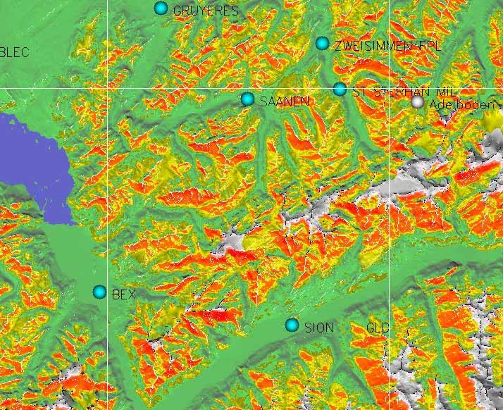
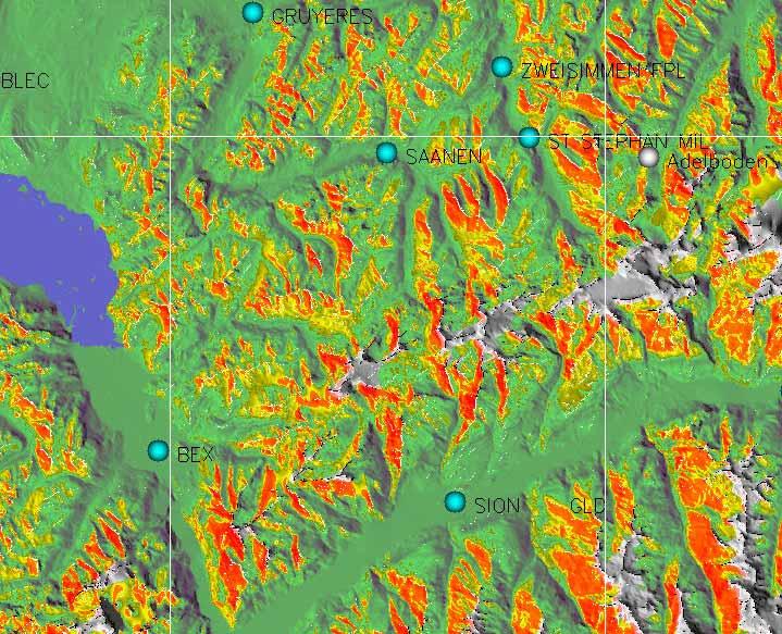
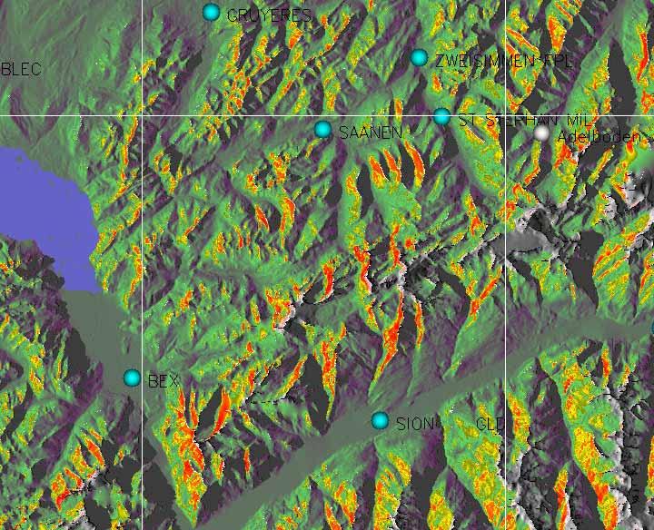
15 Example: Temperature 1100h 1300h 1700h MEZ 1500h MEZ Temperature, Valais/CH, May 6th 15
16 Thermal Take-Off Spots (von Kalckreuth s rule) Thermals climb along slope until angle drops below 30 degrees 16

17 Example: Take-Off Spots on Overlay Temperature Map (Sisteron( May 6, 1300 MEZ) 17
 (if possible) comments by the pilots Regions: Alps, Jura,, Black Forest/DE")
18 Model Validation Expert advice Overlayed IGC logfiles of flights on days with few and high clouds unstable atmosphere (temperature increase leading to thermals) (if possible) comments by the pilots Regions: Alps, Jura,, Black Forest/DE 18
19 Validation: Net Vario Vario Net Vario Speed Actual Vario Polar curve Actual speed 19
20 June 28 Engadin June 28 Validation Examples June 28 20

 Temperature Not sufficient for still smoother")
21 Conclusions TherMap model seems to be valid for topographically highly differentiated areas, such as the Alps Mixed results for topographically smoother regions, such as the Jura: (+) Irradiance (~) Temperature Not sufficient for still smoother regions OK ~ X 21

22 Note on Irradiance Maps in Smooth Areas Thermal map The The similarity would would seem seem to to justify justify further research Irradiance map 22
23 Next Steps Internet publication: : Maps, forum, services R&D on Secondary IR effects (lakes, ice, vegetation, satellite IR scans) Variation of turbidity Temperature model Secondary aerodynamic effects Refined flight tracking (wind drift, ground tracks) Extention to non-alpine regions Help and Advice Welcome! 23

24 Thank You 24
Solar Resource Mapping in South Africa
 Solar Resource Mapping in South Africa Tom Fluri Stellenbosch, 27 March 2009 Outline The Sun and Solar Radiation Datasets for various technologies Tools for Solar Resource Mapping Maps for South Africa
Solar Radiation Measurements and Model Calculations at Inclined Surfaces
 Solar Radiation Measurements and Model Calculations at Inclined Surfaces Kazadzis S. 1*, Raptis I.P. 1, V. Psiloglou 1, Kazantzidis A. 2, Bais A. 3 1 Institute for Environmental Research and Sustainable
Global Solar Dataset for PV Prospecting. Gwendalyn Bender Vaisala, Solar Offering Manager for 3TIER Assessment Services
 Global Solar Dataset for PV Prospecting Gwendalyn Bender Vaisala, Solar Offering Manager for 3TIER Assessment Services Vaisala is Your Weather Expert! We have been helping industries manage the impact
Solar resource. Radiation from the Sun Atmospheric effects Insolation maps Tracking the Sun PV in urban environment
 SOLAR RESOURCE 1 Solar resource Radiation from the Sun Atmospheric effects Insolation maps Tracking the Sun PV in urban environment 2 Solar resource Solar resource is immense Human energy use: 4.0x10 14
PV 2012/2013. Radiation from the Sun Atmospheric effects Insolation maps Tracking the Sun PV in urban environment
 SOLAR RESOURCE Radiation from the Sun Atmospheric effects Insolation maps Tracking the Sun PV in urban environment 1 is immense Human energy use: 4.0x10 14 kwh/year on Earth s surface: 5.5x10 17 kwh/year
Characterization of the solar irradiation field for the Trentino region in the Alps
 Characterization of the solar irradiation field for the Trentino region in the Alps L. Laiti*, L. Giovannini and D. Zardi Atmospheric Physics Group University of Trento - Italy outline of the talk Introduction
A WEATHER MODEL, WHAT IS IT? Jean Oberson, February-March 2010
 A WEATHER MODEL, WHAT IS IT? Jean Oberson, February 2010 Some pilots come to me and still ask some basic questions about models sometimes because they consider the models do not do prediction properly
Solar Radiation and Solar Programs. Training Consulting Engineering Publications GSES P/L
 Solar Radiation and Solar Programs Training Consulting Engineering Publications SOLAR RADIATION Purposes of Solar Radiation Software Successful project planning and solar plant implementation starts by
Uncertainties in solar electricity yield prediction from fluctuation of solar radiation
 Uncertainties in solar electricity yield prediction from fluctuation of solar radiation Marcel Suri, Thomas Huld, Ewan Dunlop, Michel Albuisson, Mireille Lefèvre, Lucien Wald To cite this version: Marcel
Temperature AOSC 200 Tim Canty
 Temperature AOSC 200 Tim Canty Class Web Site: http://www.atmos.umd.edu/~tcanty/aosc200 Topics for today: Daily Temperatures Role of clouds, latitude, land/water Lecture 09 Feb 26 2019 1 Today s Weather
Accuracy of Meteonorm ( )
") Accuracy of Meteonorm (7.1.6.14035) A detailed look at the model steps and uncertainties 22.10.2015 Jan Remund Contents The atmosphere is a choatic system, not as exactly describable as many technical
Accuracy of Meteonorm (7.1.6.14035) A detailed look at the model steps and uncertainties 22.10.2015 Jan Remund Contents The atmosphere is a choatic system, not as exactly describable as many technical
THE EFFECT OF SOLAR RADIATION DATA TYPES ON CALCULATION OF TILTED AND SUNTRACKING SOLAR RADIATION
 THE EFFECT OF SOLAR RADIATION DATA TYPES ON CALCULATION OF TILTED AND SUNTRACKING SOLAR RADIATION Tomáš Cebecauer, Artur Skoczek, Marcel Šúri GeoModel Solar s.r.o., Pionierska 15, 831 02 Bratislava, Slovakia,
INTRODUCTION TO MICROWAVE REMOTE SENSING. Dr. A. Bhattacharya
 1 INTRODUCTION TO MICROWAVE REMOTE SENSING Dr. A. Bhattacharya Why Microwaves? More difficult than with optical imaging because the technology is more complicated and the image data recorded is more varied.
Probability of Cloud-Free-Line-of-Sight (PCFLOS) Derived From CloudSat and CALIPSO Cloud Observations
 Derived From CloudSat and CALIPSO Cloud Observations") Probability of Cloud-Free-Line-of-Sight (PCFLOS) Derived From CloudSat and CALIPSO Cloud Observations Donald L. Reinke, Thomas H. Vonder Haar Cooperative Institute for Research in the Atmosphere Colorado
Probability of Cloud-Free-Line-of-Sight (PCFLOS) Derived From CloudSat and CALIPSO Cloud Observations Donald L. Reinke, Thomas H. Vonder Haar Cooperative Institute for Research in the Atmosphere Colorado
Surface temperature what does this data tell us about micro-meteorological processes?
 Surface temperature what does this data tell us about micro-meteorological processes? Prof. Dr. Eberhard Parlow Meteorology, Climatology and Remote Sensing (MCR Lab) Department of Environmental Sciences
Chapter 12: Meteorology
 Chapter 12: Meteorology Section 1: The Causes of Weather 1. Compare and contrast weather and climate. 2. Analyze how imbalances in the heating of Earth s surface create weather. 3. Describe how and where
Day Microphysics RGB Nephanalysis in daytime. Meteorological Satellite Center, JMA
 Day Microphysics RGB Nephanalysis in daytime Meteorological Satellite Center, JMA What s Day Microphysics RGB? R : B04 (N1 0.86) Range : 0~100 [%] Gamma : 1.0 G : B07(I4 3.9) (Solar component) Range :
Online data and tools for estimation of solar electricity in Africa: the PVGIS approach
 Online data and tools for estimation of solar electricity in Africa: the PVGIS approach Marcel Suri, Thomas Huld, Ewan Dunlop, Michel Albuisson, Lucien Wald To cite this version: Marcel Suri, Thomas Huld,
Energy Balance and Temperature. Ch. 3: Energy Balance. Ch. 3: Temperature. Controls of Temperature
 Energy Balance and Temperature 1 Ch. 3: Energy Balance Propagation of Radiation Transmission, Absorption, Reflection, Scattering Incoming Sunlight Outgoing Terrestrial Radiation and Energy Balance Net
Energy Balance and Temperature
 Energy Balance and Temperature 1 Ch. 3: Energy Balance Propagation of Radiation Transmission, Absorption, Reflection, Scattering Incoming Sunlight Outgoing Terrestrial Radiation and Energy Balance Net
A New Predictive Solar Radiation Numerical Model
 A New Predictive Solar Radiation Numerical Model F. Díaz, G. Montero, J.M. Escobar, E. Rodríguez, R. Montenegro University Institute for Intelligent Systems and Numerical Applications in Engineering, University
The Sun and Planets Lecture Notes 6.
 The Sun and Planets Lecture Notes 6. Lecture 6 Venus 1 Spring Semester 2017 Prof Dr Ravit Helled Cover photo: Venus in true color (Courtesy of NASA) Venus Properties Venus is the second brightest natural
Earth: the Goldilocks Planet
 Earth: the Goldilocks Planet Not too hot (460 C) Fig. 3-1 Not too cold (-55 C) Wave properties: Wavelength, velocity, and? Fig. 3-2 Reviewing units: Wavelength = distance (meters or nanometers, etc.) Velocity
THE SOLAR RESOURCE: PART I MINES ParisTech Center Observation, Impacts, Energy (Tel.: +33 (0) )
 )") MASTER REST Solar Resource Part I THE SOLAR RESOURCE: PART I MINES ParisTech Center Observation, Impacts, Energy philippe.blanc@mines-paristech.fr (Tel.: +33 (0)4 93 95 74 04) MASTER REST Solar Resource
MASTER REST Solar Resource Part I THE SOLAR RESOURCE: PART I MINES ParisTech Center Observation, Impacts, Energy philippe.blanc@mines-paristech.fr (Tel.: +33 (0)4 93 95 74 04) MASTER REST Solar Resource
ON-LINE SOLAR RADIATION MONITORING SYSTEM, IN CLUJ NAPOCA, ROMANIA
 ON-LINE SOLAR RADIATION MONITORING SYSTEM, IN CLUJ NAPOCA, ROMANIA Mugur BĂLAN, Lorentz JÄNTSCHI Introduction Sun can be considered a huge source of free energy, being also the unique energy source able
Recommendations from COST 713 UVB Forecasting
 Recommendations from COST 713 UVB Forecasting UV observations UV observations can be used for comparison with models to get a better understanding of the processes influencing the UV levels reaching the
777 GROUNDSCHOOL Temperature, Stability, Fronts, & Thunderstorms
 777 GROUNDSCHOOL 2018 Temperature, Stability, Fronts, & Thunderstorms The Atmosphere Heating Transfer of heat occurs thru Radiation Advection Convection Matter changes states due to the amount of heat
RADAR Remote Sensing Application Examples
 RADAR Remote Sensing Application Examples! All-weather capability: Microwave penetrates clouds! Construction of short-interval time series through cloud cover - crop-growth cycle! Roughness - Land cover,
Time Series Model of Photovoltaic Generation for Distribution Planning Analysis. Jorge Valenzuela
 Time Series Model of Photovoltaic Generation for Distribution Planning Analysis Jorge Valenzuela Overview Introduction: The solar problem and our limitations Modeling What information do we have? Solar
CLASSICS. Handbook of Solar Radiation Data for India
 Solar radiation data is necessary for calculating cooling load for buildings, prediction of local air temperature and for the estimating power that can be generated from photovoltaic cells. Solar radiation
Surface Circulation Ocean current Surface Currents:
 All Write Round Robin G1. What makes up the ocean water? G2. What is the source of the salt found in ocean water? G3. How does the water temperature affect the density of ocean water? G4. How does the
FORECAST OF ENSEMBLE POWER PRODUCTION BY GRID-CONNECTED PV SYSTEMS
 FORECAST OF ENSEMBLE POWER PRODUCTION BY GRID-CONNECTED PV SYSTEMS Elke Lorenz*, Detlev Heinemann*, Hashini Wickramarathne*, Hans Georg Beyer +, Stefan Bofinger * University of Oldenburg, Institute of
Liliana Pagliero June, 15 th 2011
 Liliana Pagliero liliana.pagliero@jrc.ec.europa.eu June, 15 th 2011 2/18 SWAT MODELLING AT PAN EUROPEAN SCALE: THE DANUBE BASIN PILOT STUDY Introduction The Danube Model Available databases Model set up
Land Surface Temperature Measurements From the Split Window Channels of the NOAA 7 Advanced Very High Resolution Radiometer John C.
 Land Surface Temperature Measurements From the Split Window Channels of the NOAA 7 Advanced Very High Resolution Radiometer John C. Price Published in the Journal of Geophysical Research, 1984 Presented
ATMOSPHERIC CIRCULATION AND WIND
 ATMOSPHERIC CIRCULATION AND WIND The source of water for precipitation is the moisture laden air masses that circulate through the atmosphere. Atmospheric circulation is affected by the location on the
PTYS 214 Spring Announcements. Midterm 3 next Thursday!
 PTYS 214 Spring 2018 Announcements Midterm 3 next Thursday! 1 Previously Habitable Zone Energy Balance Emission Temperature Greenhouse Effect Vibration/rotation bands 2 Recap: Greenhouse gases In order
Climate Change: Global Warming Claims
 Climate Change: Global Warming Claims Background information (from Intergovernmental Panel on Climate Change): The climate system is a complex, interactive system consisting of the atmosphere, land surface,
ESS 111 Climate & Global Change. Week 1 Weather vs Climate Structure of the Atmosphere Global Wind Belts
 ESS 111 Climate & Global Change Week 1 Weather vs Climate Structure of the Atmosphere Global Wind Belts Weather is the state of the atmosphere at a given place and time. For example, right now, the temperature
Spectrum of Radiation. Importance of Radiation Transfer. Radiation Intensity and Wavelength. Lecture 3: Atmospheric Radiative Transfer and Climate
 Lecture 3: Atmospheric Radiative Transfer and Climate Radiation Intensity and Wavelength frequency Planck s constant Solar and infrared radiation selective absorption and emission Selective absorption
A Time Lag Model to Estimate Rainfall Rate Based on GOES Data
 A Time Lag Model to Estimate Rainfall Rate Based on GOES Data Nazario D. Ramirez, Robert J. Kuligowski, and Joan M. Castro Octava Reunión Nacional de Percepción Remota y Sistemas Geográficos de Información
Lecture 3: Atmospheric Radiative Transfer and Climate
 Lecture 3: Atmospheric Radiative Transfer and Climate Solar and infrared radiation selective absorption and emission Selective absorption and emission Cloud and radiation Radiative-convective equilibrium
Chapter 2 Available Solar Radiation
 Chapter 2 Available Solar Radiation DEFINITIONS Figure shows the primary radiation fluxes on a surface at or near the ground that are important in connection with solar thermal processes. DEFINITIONS It
Earth s Energy Budget: How Is the Temperature of Earth Controlled?
 1 NAME Investigation 2 Earth s Energy Budget: How Is the Temperature of Earth Controlled? Introduction As you learned from the reading, the balance between incoming energy from the sun and outgoing energy
SNOWMELT MASS AND ENERGY BALANCE ON A STEEP SLOPE
 UNIVERSITA DEGLI STUDI DI TORINO POLITECNICO DI TORINO Dipartimento Interateneo di Scienze, Progetto e Politiche del Territorio SNOWMELT MASS AND ENERGY BALANCE ON A STEEP SLOPE Partially funded by NEXTSNOW
Remote Sensing in Meteorology: Satellites and Radar. AT 351 Lab 10 April 2, Remote Sensing
 Remote Sensing in Meteorology: Satellites and Radar AT 351 Lab 10 April 2, 2008 Remote Sensing Remote sensing is gathering information about something without being in physical contact with it typically
Name Per Date Earth Science Climate & Insolation Test
 Name Per Date Earth Science Climate & Insolation Test 1) Which graph best represents the general relationship between latitude and average surface temperature? 2) The diagram below shows the apparent path
Polar regions Temperate Regions Tropics High ( cirro ) 3-8 km 5-13 km 6-18 km Middle ( alto ) 2-4 km 2-7 km 2-8 km Low ( strato ) 0-2 km 0-2 km 0-2 km
 3-8 km 5-13 km 6-18 km Middle ( alto ) 2-4 km 2-7 km 2-8 km Low ( strato ) 0-2 km 0-2 km 0-2 km") Clouds and Climate Clouds (along with rain, snow, fog, haze, etc.) are wet atmospheric aerosols. They are made up of tiny spheres of water from 2-100 m which fall with terminal velocities of a few cm/sec.
Clouds and Climate Clouds (along with rain, snow, fog, haze, etc.) are wet atmospheric aerosols. They are made up of tiny spheres of water from 2-100 m which fall with terminal velocities of a few cm/sec.
GEOGRAPHY AND HISTORY
 GEOGRAPHY AND HISTORY YEAR 1, PART 1 www.vicensvives.es Contents 01 Our planet Earth 02 The representation of the Earth: maps 03 The Earth s relief 04 Rivers and seas 05 Weather and climate 06 Climates
IMPROVED MODEL FOR FORECASTING GLOBAL SOLAR IRRADIANCE DURING SUNNY AND CLOUDY DAYS. Bogdan-Gabriel Burduhos, Mircea Neagoe *
 DOI: 10.2478/awutp-2018-0002 ANNALS OF WEST UNIVERSITY OF TIMISOARA PHYSICS Vol. LX, 2018 IMPROVED MODEL FOR FORECASTING GLOBAL SOLAR IRRADIANCE DURING SUNNY AND CLOUDY DAYS Bogdan-Gabriel Burduhos, Mircea
ATM S 111: Global Warming Solar Radiation. Jennifer Fletcher Day 2: June
 ATM S 111: Global Warming Solar Radiation Jennifer Fletcher Day 2: June 22 2010 Yesterday We Asked What factors influence climate at a given place? Sunshine (and latitude) Topography/mountains Proximity
SUPPORTING INFORMATION. Ecological restoration and its effects on the
 SUPPORTING INFORMATION Ecological restoration and its effects on the regional climate: the case in the source region of the Yellow River, China Zhouyuan Li, Xuehua Liu,* Tianlin Niu, De Kejia, Qingping
Image 1: Earth from space
 Image 1: Earth from space Credit: NASA Spacecraft: Apollo 17 Sensor: camera using visible light Image date: December 7, 1972 This image is a photograph of Earth taken by Harrison "Jack" Schmitt, an astronaut
Lecture 4: Meteorological Satellites and Instruments. Acknowledgement: Dr. S. Kidder at Colorado State Univ.
 Lecture 4: Meteorological Satellites and Instruments Acknowledgement: Dr. S. Kidder at Colorado State Univ. Homework for the Spring Break: get some tangible, preliminary results for your final project.
SUNY Satellite-to-Solar Irradiance Model Improvements
 SUNY Satellite-to-Solar Irradiance Model Improvements Higher-accuracy in snow and high-albedo conditions with SolarAnywhere Data v3 SolarAnywhere Juan L Bosch, Adam Kankiewicz and John Dise Clean Power
Energy and the Earth AOSC 200 Tim Canty
 Energy and the Earth AOSC 200 Tim Canty Class Web Site: http://www.atmos.umd.edu/~tcanty/aosc200 Topics for today: Energy absorption Radiative Equilibirum Lecture 08 Feb 21 2019 1 Today s Weather Map http://www.wpc.ncep.noaa.gov/sfc/namussfcwbg.gif
Appendix B. A proposition for updating the environmental standards using real Earth Albedo and Earth IR Flux for Spacecraft Thermal Analysis
 19 Appendix B A proposition for updating the environmental standards using real Earth Albedo and Earth IR Romain Peyrou-Lauga (ESA/ESTEC, The Netherlands) 31 st European Space Thermal Analysis Workshop
Calculating equation coefficients
 Solar Energy 1 Calculating equation coefficients Construction Conservation Equation Surface Conservation Equation Fluid Conservation Equation needs flow estimation needs radiation and convection estimation
Weather Forecasts and Climate AOSC 200 Tim Canty. Class Web Site: Lecture 27 Dec
 Weather Forecasts and Climate AOSC 200 Tim Canty Class Web Site: http://www.atmos.umd.edu/~tcanty/aosc200 Topics for today: Climate Natural Variations Feedback Mechanisms Lecture 27 Dec 4 2018 1 Climate
- satellite orbits. Further Reading: Chapter 04 of the text book. Outline. - satellite sensor measurements
 (1 of 12) Further Reading: Chapter 04 of the text book Outline - satellite orbits - satellite sensor measurements - remote sensing of land, atmosphere and oceans (2 of 12) Introduction Remote Sensing:
Spectral Albedos. a: dry snow. b: wet new snow. c: melting old snow. a: cold MY ice. b: melting MY ice. d: frozen pond. c: melting FY white ice
 Spectral Albedos a: dry snow b: wet new snow a: cold MY ice c: melting old snow b: melting MY ice d: frozen pond c: melting FY white ice d: melting FY blue ice e: early MY pond e: ageing ponds Extinction
Ground-based Validation of spaceborne lidar measurements
 Ground-based Validation of spaceborne lidar measurements Ground-based Validation of spaceborne lidar measurements to make something officially acceptable or approved, to prove that something is correct
1 A 3 C 2 B 4 D. 5. During which month does the minimum duration of insolation occur in New York State? 1 February 3 September 2 July 4 December
 INSOLATION REVIEW 1. The map below shows isolines of average daily insolation received in calories per square centimeter per minute at the Earth s surface. If identical solar collectors are placed at the
JOINT WMO TECHNICAL PROGRESS REPORT ON THE GLOBAL DATA PROCESSING AND FORECASTING SYSTEM AND NUMERICAL WEATHER PREDICTION RESEARCH ACTIVITIES FOR 2016
 JOINT WMO TECHNICAL PROGRESS REPORT ON THE GLOBAL DATA PROCESSING AND FORECASTING SYSTEM AND NUMERICAL WEATHER PREDICTION RESEARCH ACTIVITIES FOR 2016 New Zealand / Meteorological Service of New Zealand
HIGH TEMPORAL AND SPATIAL RESOLUTION AIR TEMPERATURE RETRIEVAL FROM SEVIRI AND MODIS COMBINED DATA
 HIGH TEMPORAL AND SPATIAL RESOLUTION AIR TEMPERATURE RETRIEVAL FROM SEVIRI AND MODIS COMBINED DATA Attilio Gambardella 1, Klemen Zakšek 2,3, Thomas Huld 1, and Marion Schroeder-Homscheidt 4 1 Institute
Atmospheric Moisture, Precipitation, and Weather Systems
 Atmospheric Moisture, Precipitation, and Weather Systems 6 Chapter Overview The atmosphere is a complex system, sometimes described as chaotic in nature. In this chapter we examine one of the principal
Sunlight and Temperature
 Sunlight and Temperature Name Purpose: Study microclimate differences due to sunlight exposure, location, and surface; practice environmental measurements; study natural energy flows; compare measurements;
For the operational forecaster one important precondition for the diagnosis and prediction of
 Initiation of Deep Moist Convection at WV-Boundaries Vienna, Austria For the operational forecaster one important precondition for the diagnosis and prediction of convective activity is the availability
Sunlight and its Properties II. EE 446/646 Y. Baghzouz
 Sunlight and its Properties II EE 446/646 Y. Baghzouz Solar Time (ST) and Civil (clock) Time (CT) There are two adjustments that need to be made in order to convert ST to CT: The first is the Longitude
Monitoring daily evapotranspiration in the Alps exploiting Sentinel-2 and meteorological data
 Monitoring daily evapotranspiration in the Alps exploiting Sentinel-2 and meteorological data M. Castelli, S. Asam, A. Jacob, M. Zebisch, and C. Notarnicola Institute for Earth Observation, Eurac Research,
Climate 1: The Climate System
 Climate 1: The Climate System Prof. Franco Prodi Institute of Atmospheric Sciences and Climate National Research Council Via P. Gobetti, 101 40129 BOLOGNA SIF, School of Energy, Varenna, July 2014 CLIMATE
Why modelling? Glacier mass balance modelling
 Why modelling? Glacier mass balance modelling GEO 4420 Glaciology 12.10.2006 Thomas V. Schuler t.v.schuler@geo.uio.no global mean temperature Background Glaciers have retreated world-wide during the last
Torben Königk Rossby Centre/ SMHI
 Fundamentals of Climate Modelling Torben Königk Rossby Centre/ SMHI Outline Introduction Why do we need models? Basic processes Radiation Atmospheric/Oceanic circulation Model basics Resolution Parameterizations
A Novel Method for Predicting the Power Output of Distributed Renewable Energy Resources
 A Novel Method for Predicting the Power Output of Distributed Renewable Energy Resources Athanasios Aris Panagopoulos1 Supervisor: Georgios Chalkiadakis1 Technical University of Crete, Greece A thesis
Scientific Challenges of UV-B Forecasting
 Scientific Challenges of UV-B Forecasting Henning Staiger, German Meteorological Service (DWD) International activities and the UV Index UV Index definition and forecasting requirements Challenges in calculation
Lecture 3A: Interception
 3-1 GEOG415 Lecture 3A: Interception What is interception? Canopy interception (C) Litter interception (L) Interception ( I = C + L ) Precipitation (P) Throughfall (T) Stemflow (S) Net precipitation (R)
Thermal And Near infrared Sensor for carbon Observation (TANSO) onboard the Greenhouse gases Observing SATellite (GOSAT) Research Announcement
 onboard the Greenhouse gases Observing SATellite (GOSAT) Research Announcement") Thermal And Near infrared Sensor for carbon Observation (TANSO) onboard the Greenhouse gases Observing SATellite (GOSAT) Research Announcement Appendix C Operation Policies of GOSAT and Basic Observation
Thermal And Near infrared Sensor for carbon Observation (TANSO) onboard the Greenhouse gases Observing SATellite (GOSAT) Research Announcement Appendix C Operation Policies of GOSAT and Basic Observation
Worldwide Data Quality Effects on PBL Short-Range Regulatory Air Dispersion Models
 Worldwide Data Quality Effects on PBL Short-Range Regulatory Air Dispersion Models Jesse L. Thé 1, Russell Lee 2, Roger W. Brode 3 1 Lakes Environmental Software, -2 Philip St, Waterloo, ON, N2L 5J2, Canada
Solar Radiation and Environmental Biophysics Geo 827, MSU Jiquan Chen Oct. 6, 2015
 Solar Radiation and Environmental Biophysics Geo 827, MSU Jiquan Chen Oct. 6, 2015 1) Solar radiation basics 2) Energy balance 3) Other relevant biophysics 4) A few selected applications of RS in ecosystem
The Sun s Role in Climate Change. Philip R. Goode Big Bear Solar Observatory Center for Solar-Terrestrial Research New Jersey Institute of Technology
 The Sun s Role in Climate Change Philip R. Goode Center for Solar-Terrestrial Research New Jersey Institute of Technology Changes in Earth s Climate In the most basic sense, it depends on changes in The
NEW CGMS BASELINE FOR THE SPACE-BASED GOS. (Submitted by the WMO Secretariat) Summary and Purpose of Document
 Summary and Purpose of Document") WORLD METEOROLOGICAL ORGANIZATION COMMISSION FOR BASIC SYSTEMS OPEN PROGRAMME AREA GROUP ON INTEGRATED OBSERVING SYSTEMS EXPERT TEAM ON SATELLITE SYSTEMS ET-SAT-7/Inf. 2 (12.III.2012) ITEM: 8.1 SEVENTH
WORLD METEOROLOGICAL ORGANIZATION COMMISSION FOR BASIC SYSTEMS OPEN PROGRAMME AREA GROUP ON INTEGRATED OBSERVING SYSTEMS EXPERT TEAM ON SATELLITE SYSTEMS ET-SAT-7/Inf. 2 (12.III.2012) ITEM: 8.1 SEVENTH
ATMOS 5140 Lecture 1 Chapter 1
 ATMOS 5140 Lecture 1 Chapter 1 Atmospheric Radiation Relevance for Weather and Climate Solar Radiation Thermal Infrared Radiation Global Heat Engine Components of the Earth s Energy Budget Relevance for
Uncertainty of satellite-based solar resource data
 Uncertainty of satellite-based solar resource data Marcel Suri and Tomas Cebecauer GeoModel Solar, Slovakia 4th PV Performance Modelling and Monitoring Workshop, Köln, Germany 22-23 October 2015 About
ATMOSPHERIC ENERGY and GLOBAL TEMPERATURES. Physical Geography (Geog. 300) Prof. Hugh Howard American River College
 Prof. Hugh Howard American River College") ATMOSPHERIC ENERGY and GLOBAL TEMPERATURES Physical Geography (Geog. 300) Prof. Hugh Howard American River College RADIATION FROM the SUN SOLAR RADIATION Primarily shortwave (UV-SIR) Insolation Incoming
ATMOSPHERIC ENERGY and GLOBAL TEMPERATURES Physical Geography (Geog. 300) Prof. Hugh Howard American River College RADIATION FROM the SUN SOLAR RADIATION Primarily shortwave (UV-SIR) Insolation Incoming
Short term forecasting of solar radiation based on satellite data
 Short term forecasting of solar radiation based on satellite data Elke Lorenz, Annette Hammer, Detlev Heinemann Energy and Semiconductor Research Laboratory, Institute of Physics Carl von Ossietzky University,
Remote Sensing I: Basics
 Remote Sensing I: Basics Kelly M. Brunt Earth System Science Interdisciplinary Center, University of Maryland Cryospheric Science Laboratory, Goddard Space Flight Center kelly.m.brunt@nasa.gov (Based on
A R C T E X Results of the Arctic Turbulence Experiments Long-term Monitoring of Heat Fluxes at a high Arctic Permafrost Site in Svalbard
 A R C T E X Results of the Arctic Turbulence Experiments www.arctex.uni-bayreuth.de Long-term Monitoring of Heat Fluxes at a high Arctic Permafrost Site in Svalbard 1 A R C T E X Results of the Arctic
CGMS Baseline In response to CGMS action/recommendation A45.01 HLPP reference: 1.1.8
 Prepared by WGIII Agenda Item: 7.1 Discussed in WGIII CGMS Baseline In response to CGMS action/recommendation A45.01 HLPP reference: 1.1.8 In CGMS-45, Working Group III agreed to hold a review of the CGMS
A perturbed physics ensemble climate modeling. requirements of energy and water cycle. Yong Hu and Bruce Wielicki
 A perturbed physics ensemble climate modeling study for defining satellite measurement requirements of energy and water cycle Yong Hu and Bruce Wielicki Motivation 1. Uncertainty of climate sensitivity
1 Our Dynamic Climate Guiding Question: What factors determine Earth s climate?
 LESSON 1 Our Dynamic Climate Guiding Question: What factors determine Earth s climate? Describe factors that affect how the sun warms Earth. Discuss the role of wind patterns in determining climate. Explain
The Status Report of FY-2F
 Seventh Session of the Expert Team on Satellite Utilization and Products The Status Report of FY-2F Presented by Xiang Fang National Satellite Meteorological Center (NSMC) China Meteorological Administration
Parameterization for Atmospheric Radiation: Some New Perspectives
 Parameterization for Atmospheric Radiation: Some New Perspectives Kuo-Nan Liou Joint Institute for Regional Earth System Science and Engineering (JIFRESSE) and Atmospheric and Oceanic Sciences Department
Basic cloud Interpretation using Satellite Imagery
 Basic cloud Interpretation using Satellite Imagery Introduction Recall that images from weather satellites are actually measurements of energy from specified bands within the Electromagnetic (EM) spectrum.
Detection of ship NO 2 emissions over Europe from satellite observations
 Detection of ship NO 2 emissions over Europe from satellite observations Huan Yu DOAS seminar 24 April 2015 Ship Emissions to Atmosphere Reporting Service (SEARS project) Outline Introduction Shipping
Energy Systems, Structures and Processes Essential Standard: Analyze patterns of global climate change over time Learning Objective: Differentiate
 Energy Systems, Structures and Processes Essential Standard: Analyze patterns of global climate change over time Learning Objective: Differentiate between weather and climate Global Climate Focus Question
Climate System. Sophie Zechmeister-Boltenstern
 Climate System Sophie Zechmeister-Boltenstern Reference: Chapin F. St., Matson P., Mooney Harold A. 2002 Principles of Terrestrial Ecosystem Ecology. Springer, Berlin, 490 p. Structure of this lecture
Cartographic analysis of avalanche hazard maps A comparison of relevant cartographic factors for the visualization of the avalanche bulletin
 Cartographic analysis of avalanche hazard maps A comparison of relevant cartographic factors for the visualization of the avalanche bulletin Markus Eckerstorfer, Karel Kriz University of Vienna, Department
GEO1010 tirsdag
 GEO1010 tirsdag 31.08.2010 Jørn Kristiansen; jornk@met.no I dag: Først litt repetisjon Stråling (kap. 4) Atmosfærens sirkulasjon (kap. 6) Latitudinal Geographic Zones Figure 1.12 jkl TØRR ATMOSFÆRE Temperature
Glaciology HEAT BUDGET AND RADIATION
 HEAT BUDGET AND RADIATION A Heat Budget 1 Black body radiation Definition. A perfect black body is defined as a body that absorbs all radiation that falls on it. The intensity of radiation emitted by a
Motion of the Sun. View Comments
 Login 2017 Survey to Improve Photovoltaic Education Christiana Honsberg and Stuart Bowden View Comments Instructions 1. Introduction 2. Properties of Sunlight 2.1. Basics of Light Properties of Light Energy
Pilots watch the clouds, because clouds can indicate the kind of weather in store for a flight.
 Low stratus Cumulonimbus Pilots watch the clouds, because clouds can indicate the kind of weather in store for a flight. FILL IN THE BLANKS OR CIRCLE ONE: A. Stratus means flat or on one level. Low stratus