Dr Marc Lucas CLS Toulouse, France.
|
|
|
- Suzan Harper
- 6 years ago
- Views:
Transcription

1 Dr Marc Lucas CLS Toulouse, France. Oceanology International 15th March 2012 Slide 1

2 Ocean depiction In the past: Information mainly comes from in situ measurements (ADCP) Now: The role of satellite data and numerical models will become increasingly important for offshore applications Oceanology International 15th March 2012 Slide 2
3 Surface currents Today the knowledge of sea surface currents is not accurate enough for many operations at sea New methodology: To compute and forecast sea surface currents Hybrid currents That combines: In situ data Satellite observations Numerical atmospheric and ocean models Oceanology International 15th March 2012 Slide 3
 Sensors on ships")

 Oceanology International 15th March")
4 In situ observations Oceanographic in situ data: ADCP Buoys (Argo, moored buoys ) Sensors on ships T/S profiles from CTD, XBT, Argo floats, moorings Surface currents from surface drifters Accurate data but limited to one point (no regional visibility) Oceanology International 15th March 2012 Slide 4
5 Need to improve the surface currents At higher frequencies In space (increased spatial resolution) In time (higher frequency) Accuracy Along coastlines In shallow waters Whilst keeping the accuracy of open ocean products derived from satellite observations Oceanology International 15th March 2012 Slide 5


6 Observations from space Types of satellite observations: Altimetry: ocean topography Sea Surface Heights Surface Currents Ocean Colour Sea Surface Temperature Oceanology International 15th March 2012 Slide 6


 Real-time")

7 Observations from space Jason Advantages of satellite observations : 2D regional visibility Long-term monitoring (over 20 years) Real-time monitoring (a few hours) Envisat Aqua Oceanology International 15th March 2012 Slide 7
 Currents are turning around eddies Oceanology International 15th March 2012")
8 Altimetry With satellite observations of ocean topography and currents: Anticyclonic (bump) Cyclonic (hollow) Currents are turning around eddies Oceanology International 15th March 2012 Slide 8

 Ocean color :")

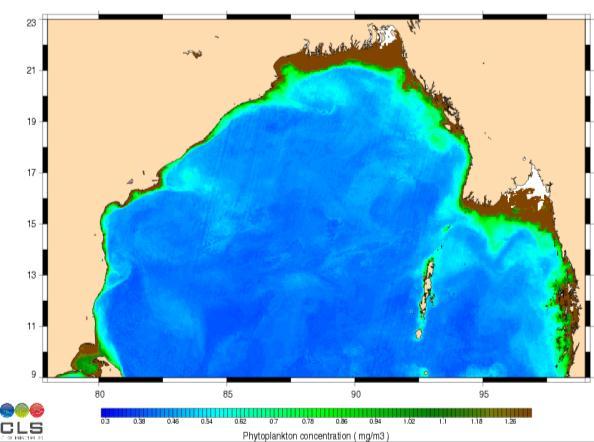
9 Ocean colour To locate and monitor eddies To detect and monitor river plumes To track eddies To locate currents (coastal currents, Loop Current ) Ocean color : trace the movement of water masses from space Oceanology International 15th March 2012 Slide 9


10 Sea Surface Temperature To locate fronts To locate upwelling To separate water masses Sea surface temperature : locate water masses from space Oceanology International 15th March 2012 Slide 10

11 Numerical ocean models Provides ocean currents in 2D or 3D over time Not real observation but regional visibility and forecast possibility Oceanology International 15th March 2012 Slide 11
")
 High frequency")

12 Tide models Global tide model (open boundaries) Regional models (refines meshes) High frequency hourly currents Oceanology International 15th March 2012 Slide 12

13 Atmospheric models Winds extracted from: European Centre Medium RangeWeather Forecasting products Regional weather models Used to compute wind driven currents Oceanology International 15th March 2012 Slide 13
14 Hybrid surface currents Main idea => to combine : Satellite observations In situ observations Numerical models outputs (atmospheric and ocean) To take advantage of all the main characteristics of each of these inputs Oceanology International 15th March 2012 Slide 14


15 Hybrid surface current Oceanology International 15th March 2012 Slide 15

16 Hybrid currents schematic Altimetric heights Observations Altimetric currents Wind stress Bathymetry Numerical ocean model SWW2D model Data Fitting Sea Surface Temperature Ocean Color Tidal potential SQG Model SQG Model Tide Model Hybrid surface current Oceanology International 15th March 2012 Slide 16

17 Main characteristics Hybrid currents: Spatial resolution: 1/30 (~4km) Time resolution: Hourly Forecast: 48h Oceanology International 15th March 2012 Slide 17

18 Offshore Angola results Comparison with drifters in the area: 4 S-8 S; 9 E-15 E DRIFTERS ANGOLA HYBRID MODEL Oceanology International 15th March 2012 Page 18


19 Data Fitting Important to anchor model field to in situ observation Oceanology International 15th March 2012 Slide 19


20 Data Fitting Oceanology International 15th March 2012 Slide 20
21 Conclusion New method developed to provide 2D vision Massively based on observations: Satellite (SST,SSH,OC) In situ (ADCP, buoys) Uses also input from models Results are promising but: Lack of observations is the main obstacle Very cheap numerically: allows the possibility of stochastic (ensemble) modeling. Oceanology International 15th March 2012 Slide 21

22 Please come and visit us on stand E450 Oceanology International 15th March 2012 Slide 22
Ocean currents from altimetry
 Ocean currents from altimetry Pierre-Yves LE TRAON - CLS - Space Oceanography Division Gamble Workshop - Stavanger,, May 2003 Introduction Today: information mainly comes from in situ measurements ocean
Use of Satellite Earth Observations, in situ data and numerical model capabilities for oil spill contingency. Page 1
 Use of Satellite Earth Observations, in situ data and numerical model capabilities for oil spill contingency Page 1 Oil spill service Page 2 Interest of Earth-Observation (EO) data for oil and gas companies
A Modeling Study on Flows in the Strait of Hormuz (SOH)
") A Modeling Study on Flows in the Strait of Hormuz (SOH) Peter C Chu & Travis Clem Naval Postgraduate School Monterey, CA 93943, USA IUGG 2007: PS005 Flows and Waves in Straits. July 5-6, Perugia, Italy
A Modeling Study on Flows in the Strait of Hormuz (SOH) Peter C Chu & Travis Clem Naval Postgraduate School Monterey, CA 93943, USA IUGG 2007: PS005 Flows and Waves in Straits. July 5-6, Perugia, Italy
Introduction to Ocean Numerical Modeling #0 General Introduction. Global model SSH regional model SST
 Introduction to Ocean Numerical Modeling #0 General Introduction Global model SSH regional model SST Gildas Cambon, IRD/LOPS, France gildas.cambon@ird.fr Global model SSH WEEK 1 regional model SST Day
How DBCP Data Contributes to Ocean Forecasting at the UK Met Office
 How DBCP Data Contributes to Ocean Forecasting at the UK Met Office Ed Blockley DBCP XXVI Science & Technical Workshop, 27 th September 2010 Contents This presentation covers the following areas Introduction
Oceanology International, London, March 2012 Ocean Observation & Forecasting programme. An African Network of Offshore Real-Time Metocean Stations
 Oceanology International, London, March 2012 Ocean Observation & Forecasting programme An African Network of Offshore Real-Time Metocean Stations Valérie QUINIOU-RAMUS, Rémi ESTIVAL (TOTAL S.A., EP/DEV/TEC/GEO)
The Mediterranean Operational Oceanography Network (MOON): Products and Services
: Products and Services") The Mediterranean Operational Oceanography Network (MOON): Products and Services The MOON consortia And Nadia Pinardi Co-chair of MOON Istituto Nazionale di Geofisica e Vulcanologia Department of Environmental
The Mediterranean Operational Oceanography Network (MOON): Products and Services The MOON consortia And Nadia Pinardi Co-chair of MOON Istituto Nazionale di Geofisica e Vulcanologia Department of Environmental
Coastal Ocean Circulation Experiment off Senegal (COCES)
") DISTRIBUTION STATEMENT A. Approved for public release; distribution is unlimited. Coastal Ocean Circulation Experiment off Senegal (COCES) Pierre-Marie Poulain Istituto Nazionale di Oceanografia e di Geofisica
DISTRIBUTION STATEMENT A. Approved for public release; distribution is unlimited. Coastal Ocean Circulation Experiment off Senegal (COCES) Pierre-Marie Poulain Istituto Nazionale di Oceanografia e di Geofisica
EO Information Services in support of West Africa Coastal vulnerability Service 2 : Sea Level Height & currents. Vinca Rosmorduc, CLS
 EO Information Services in support of West Africa Coastal vulnerability Service 2 : Sea Level Height & currents Vinca Rosmorduc, CLS World Bank HQ, Washington DC Date : 23 February 2012 West Africa coastal
MERSEA Marine Environment and Security for the European Area
 MERSEA Marine Environment and Security for the European Area Development of a European system for operational monitoring and forecasting of the ocean physics, biogeochemistry, and ecosystems, on global
Impact of Argo, SST, and altimeter data on an eddy-resolving ocean reanalysis
 Click Here for Full Article GEOPHYSICAL RESEARCH LETTERS, VOL. 34, L19601, doi:10.1029/2007gl031549, 2007 Impact of Argo, SST, and altimeter data on an eddy-resolving ocean reanalysis Peter R. Oke 1 and
Southern Florida to Cape Hatteras Spring Season Preview 2018 UPDATE ON U.S. EAST COAST GULF STREAM CONDITIONS
 Southern Florida to Cape Hatteras Spring Season Preview 2018 UPDATE ON U.S. EAST COAST GULF STREAM CONDITIONS By ROFFS Gregory J. Gawlikowski ROFFS continues its spring preview series by providing an overall
Overview of data assimilation in oceanography or how best to initialize the ocean?
 Overview of data assimilation in oceanography or how best to initialize the ocean? T. Janjic Alfred Wegener Institute for Polar and Marine Research Bremerhaven, Germany Outline Ocean observing system Ocean
Recent Developments in the Navy Coastal Ocean Model and its application as the ocean component in regional coupled forecast models
 Recent Developments in the Navy Coastal Ocean Model and its application as the ocean component in regional coupled forecast models Tommy Jensen, Paul Martin, Clark Rowley, Tim Campbell, Richard Allard,
Earth Observation in coastal zone MetOcean design criteria
 ESA Oil & Gas Workshop 2010 Earth Observation in coastal zone MetOcean design criteria Cees de Valk BMT ARGOSS Wind, wave and current design criteria geophysical process uncertainty modelling assumptions
Developing Coastal Ocean Forecasting Systems and Their Applications
 Developing Coastal Ocean Forecasting Systems and Their Applications Xiaochun Wang a,b LASG/IAP, CAS, July 23, 2010 Contributions from: JPL Yi Chao, John Farrara, Peggy Li, Zhijin Li, Quoc Vu, Hongchun
Can buoys predict hurricanes? Objectives Students will be able to: track drifter buoys determine the course of the gulf stream current
 Drifters Can buoys predict hurricanes? Objectives Students will be able to: track drifter buoys determine the course of the gulf stream current Materials computers with Internet access Student Worksheet
Overview of HYCOM activities at SHOM
 Overview of HYCOM activities at SHOM Stéphanie Louazel, Stéphanie Corréard, Rémy Baraille, Annick Pichon, Cyril Lathuilière, Audrey Pasquet, Emeric Baquet LOM2015 Copenhagen 2 nd 4 th June 2015 French
Impact of frontal eddy dynamics on the Loop Current variability during free and data assimilative HYCOM simulations
 Impact of frontal eddy dynamics on the Loop Current variability during free and data assimilative HYCOM simulations Matthieu Le Hénaff (1) Villy H. Kourafalou (1) Ashwanth Srinivasan (1) George R. Halliwell
Oceanography from Space
 Why study the ocean? Oceanography from Space Paolo Cipollini National Oceanography Centre, Southampton, U.K. LOCAL drivers: fisheries, shipping, transportation, coastal erosion, leisure Norwegians know
O.M Smedstad 1, E.J. Metzger 2, R.A. Allard 2, R. Broome 1, D.S. Franklin 1 and A.J. Wallcraft 2. QinetiQ North America 2. Naval Research Laboratory
 An eddy-resolving ocean reanalysis using the 1/12 global HYbrid Coordinate Ocean Model (HYCOM) and the Navy Coupled Ocean Data Assimilation (NCODA) scheme O.M Smedstad 1, E.J. Metzger 2, R.A. Allard 2,
Satellite ALTimetry. SALT applications and use of data base for SE-Asia region. SEAMERGES kick-off meeting, Bangkok, Thailand.
 Satellite ALTimetry SALT applications and use of data base for SE-Asia region SEAMERGES kick-off meeting, Bangkok, Thailand Marc Naeije 4 March 2004 1 Faculty of Aerospace Engineering DEOS/AS SEAMERGES
Development and deployment plan of ARGO type buoy in the Arctic Ocean
 1/16 Development and deployment plan of ARGO type buoy in the Arctic Ocean by T.Kikuchi, N.Shikama (JAMSTEC), D.Langevin, T.Monk, and O.Lebreton (MetOcean) 2/16 Ice-drifting buoy observation J-CAD ( JAMSTEC
Ocean Observations for Societal Benefits
 Ocean Observations for Societal Benefits OceanObs 09 Shailesh Nayak Secretary, Ministry of Earth Sciences, India September 21, 2009 Venice, Italy When the Gods stood together in the sea, then as dancers
Modeling of deep currents in the Japan/East Sea
 Modeling of deep currents in the Japan/East Sea Olga Trusenkova V.I.Il ichev Pacific Oceanological Institute, FEB RAS Vladivostok, Russia PICES 2014 Annual Meeting, 16-26 October 2014, Korea, Yeosu Deep
PS4a: Real-time modelling platforms during SOP/EOP
 PS4a: Real-time modelling platforms during SOP/EOP Mistral Tramontane Bora Etesian Major sites of dense water formation Major sites of deep water formation influence of coastal waters Chairs: G. Boni,
Active microwave systems (2) Satellite Altimetry * the movie * applications
 Satellite Altimetry * the movie * applications") Remote Sensing: John Wilkin wilkin@marine.rutgers.edu IMCS Building Room 211C 732-932-6555 ext 251 Active microwave systems (2) Satellite Altimetry * the movie * applications Altimeters (nadir pointing
Remote Sensing: John Wilkin wilkin@marine.rutgers.edu IMCS Building Room 211C 732-932-6555 ext 251 Active microwave systems (2) Satellite Altimetry * the movie * applications Altimeters (nadir pointing
Rick Krishfield and John Toole Ice-Tethered Platform Workshop June 29, 2004 Woods Hole Oceanographic Institution
 Ice-tethered Instruments: History and Future Development Rick Krishfield and John Toole Ice-Tethered Platform Workshop June 29, 2004 Woods Hole Oceanographic Institution Since the 1980s, Arctic drifting
Coastal Ocean Circulation Experiment off Senegal (COCES)
") DISTRIBUTION STATEMENT A. Approved for public release; distribution is unlimited. Coastal Ocean Circulation Experiment off Senegal (COCES) Pierre-Marie Poulain Istituto Nazionale di Oceanografia e di Geofisica
DISTRIBUTION STATEMENT A. Approved for public release; distribution is unlimited. Coastal Ocean Circulation Experiment off Senegal (COCES) Pierre-Marie Poulain Istituto Nazionale di Oceanografia e di Geofisica
Application and improvement of Ensemble Optimal Interpolation on Regional Ocean Modeling System (ROMS)
") Application and improvement of Ensemble Optimal Interpolation on Regional Ocean Modeling System (ROMS) Zhaoyi Wang Guokun Lyu, Hui Wang, Jiang Zhu, Guimei Liu et al. National Marine Environmental Forecasting
Application and improvement of Ensemble Optimal Interpolation on Regional Ocean Modeling System (ROMS) Zhaoyi Wang Guokun Lyu, Hui Wang, Jiang Zhu, Guimei Liu et al. National Marine Environmental Forecasting
Coastal Ocean Circulation Experiment off Senegal (COCES)
") DISTRIBUTION STATEMENT A: Approved for public release; distribution is unlimited. Coastal Ocean Circulation Experiment off Senegal (COCES) Pierre-Marie Poulain Istituto Nazionale di Oceanografia e di Geofisica
DISTRIBUTION STATEMENT A: Approved for public release; distribution is unlimited. Coastal Ocean Circulation Experiment off Senegal (COCES) Pierre-Marie Poulain Istituto Nazionale di Oceanografia e di Geofisica
Ocean Dynamics. The Great Wave off Kanagawa Hokusai
 Ocean Dynamics The Great Wave off Kanagawa Hokusai LO: integrate relevant oceanographic processes with factors influencing survival and growth of fish larvae Physics Determining Ocean Dynamics 1. Conservation
Initial Results of Altimetry Assimilation in POP2 Ocean Model
 Initial Results of Altimetry Assimilation in POP2 Ocean Model Svetlana Karol and Alicia R. Karspeck With thanks to the DART Group, CESM Software Development Group, Climate Modeling Development Group POP-DART
Non-linear patterns of eddy kinetic energy in the Japan/East Sea
 Non-linear patterns of eddy kinetic energy in the Japan/East Sea O.O. Trusenkova, D.D. Kaplunenko, S.Yu. Ladychenko, V.B. Lobanov V.I.Il ichev Pacific Oceanological Institute, FEB RAS Vladivostok, Russia
M. Liste 1, M. Grifoll 2, I. Keupers 1, J. Fernández 3, H. Ortega 1, J. Monbaliu 1
 M. Liste 1, M. Grifoll 2, I. Keupers 1, J. Fernández 3, H. Ortega 1, J. Monbaliu 1 1 Hydraulics Laboratory (K.U.Leuven, Belgium) 2 Laboratori d Enginyeria Marítima (LIM/UPC, Spain) 3 SIMO, Spain. Motivation
Applications of an ensemble Kalman Filter to regional ocean modeling associated with the western boundary currents variations
 Applications of an ensemble Kalman Filter to regional ocean modeling associated with the western boundary currents variations Miyazawa, Yasumasa (JAMSTEC) Collaboration with Princeton University AICS Data
Ocean Currents Student Activity Book
 Ocean Currents Student Activity Book I. Introduction Ocean currents influence the weather in coastal areas. They also influence sailing vessels. Though they visibly affect many people's lives, they are
Salinity Processes in the Upper. Ocean Regional Study (SPURS) Ray Schmitt, WHOI
 Ray Schmitt, WHOI") Salinity Processes in the Upper Outgrowth of: Ocean Regional Study (SPURS) Ray Schmitt, WHOI CLIVAR Salinity Working Group (May 06 meeting and 07 report) Salinity issue of Oceanography (Mar. 08) NASA Workshop
Salinity Processes in the Upper Outgrowth of: Ocean Regional Study (SPURS) Ray Schmitt, WHOI CLIVAR Salinity Working Group (May 06 meeting and 07 report) Salinity issue of Oceanography (Mar. 08) NASA Workshop
Operational systems for SST products. Prof. Chris Merchant University of Reading UK
 Operational systems for SST products Prof. Chris Merchant University of Reading UK Classic Images from ATSR The Gulf Stream ATSR-2 Image, ƛ = 3.7µm Review the steps to get SST using a physical retrieval
OSE/OSSEs at NOAA. Eric Bayler NOAA/NESDIS/STAR
 OSE/OSSEs at NOAA Eric Bayler NOAA/NESDIS/STAR OSE/OSSEs at NOAA NOAA Leadership view: Relatively inexpensive way to: Assess the impact of potential new observations Refine and redirect current observing
Development of JMA storm surge model
 2 nd JCOMM Scientific and Technical Symposium on Storm Surges 8-13 November 2015, Key West, Florida, USA Development of JMA storm surge model Hiroshi HASEGAWA (h_hasegawa@met.kishou.go.jp) Office of Marine
EFFECTIVE TROPICAL CYCLONE WARNING IN BANGLADESH
 Country Report of Bangladesh On EFFECTIVE TROPICAL CYCLONE WARNING IN BANGLADESH Presented At JMA/WMO WORKSHOP ON EFFECTIVE TROPICAL CYCLONE WARNING IN SOUTHEAST ASIA Tokyo, Japan,11-14 March 2014 By Sayeed
Forcing ocean model with atmospheric model outputs to simulate storm surge in the Bangladesh coast
 Forcing ocean model with atmospheric model outputs to simulate storm surge in the Bangladesh coast Nabir Mamnun 1, 2, Lucy Brechino 3, Md. Rashed-Un-Nabi 2 1. Nansen-Bangladesh International Centre for
Enhancing predictability of the Loop Current variability using Gulf of Mexico Hycom
 Enhancing predictability of the Loop Current variability using Gulf of Mexico Hycom Matthieu Le Hénaff (1) Villy Kourafalou (1) Ashwanth Srinivasan (1) Collaborators: O. M. Smedstad (2), P. Hogan (2),
Estimation of extreme sea levels from altimetry and tide gauges at the coast
 Estimation of extreme sea levels from altimetry and tide gauges at the coast Xiaoli Deng (1), Ole B. Andersen (2), Yongcun Cheng (2), Mark G. Stewart (1) and Zahra Gharineiat (1) (1) School of Engineering,
SIO 210 Problem Set 2 October 17, 2011 Due Oct. 24, 2011
 SIO 210 Problem Set 2 October 17, 2011 Due Oct. 24, 2011 1. The Pacific Ocean is approximately 10,000 km wide. Its upper layer (wind-driven gyre*) is approximately 1,000 m deep. Consider a west-to-east
Alexander Kurapov, in collaboration with R. Samelson, G. Egbert, J. S. Allen, R. Miller, S. Erofeeva, A. Koch, S. Springer, J.
 Coastal Ocean Modeling at CIOSS Alexander Kurapov, in collaboration with R. Samelson, G. Egbert, J. S. Allen, R. Miller, S. Erofeeva, A. Koch, S. Springer, J. Osborne - Pilot real-time forecast model of
Western North Pacific Integrated Physical-Biogeochemical Ocean Observation Experiment (INBOX)
") Western North Pacific Integrated Physical-Biogeochemical Ocean Observation Experiment (INBOX) Toshio Suga (JAMSTEC/Tohoku Univ.) & the INBOX Group: S. Hosoda, R. Inoue, K. Sato, K. Shinya, T. Kobayashi,
Western North Pacific Integrated Physical-Biogeochemical Ocean Observation Experiment (INBOX) Toshio Suga (JAMSTEC/Tohoku Univ.) & the INBOX Group: S. Hosoda, R. Inoue, K. Sato, K. Shinya, T. Kobayashi,
Ocean Forecasting for Australia & New Zealand and Mesoscale Oceanography
 Ocean Forecasting for Australia & New Zealand and Mesoscale Oceanography Andreas Schiller 1 Graham Rickard 2 Gary Brassington 3 1 Centre for Australian Weather and Climate Research; Wealth from Oceans
On the relative importance of Argo, SST and altimetry for an ocean reanalysis
 Document prepared on February 20, 2007 for the Argo Steering Team Meeting (AST-8), Paris March 7-9 On the relative importance of Argo, SST and altimetry for an ocean reanalysis Peter R. Oke and Andreas
Process Study of Oceanic Responses to Typhoons Using Arrays of EM-APEX Floats and Moorings
 DISTRIBUTION STATEMENT A. Approved for public release; distribution is unlimited. Process Study of Oceanic Responses to Typhoons Using Arrays of EM-APEX Floats and Moorings Ren-Chieh Lien Applied Physics
Physical factors driving the oceanographic regime around the Florida Keys. Villy Kourafalou. University of Miami/RSMAS
 Physical factors driving the oceanographic regime around the Florida Keys Villy Kourafalou University of Miami/RSMAS Oceanographic connectivity around the Florida Keys LC FC http://oceancurrents.rsmas.miami.edu/atlantic/loop-current_2.html
Ocean Mixing and Climate Change
 Ocean Mixing and Climate Change Factors inducing seawater mixing Different densities Wind stirring Internal waves breaking Tidal Bottom topography Biogenic Mixing (??) In general, any motion favoring turbulent
SEDIMENT TRANSPORT AND GO-CONG MORPHOLOGICAL CHANGE MODELING BY TELEMAC MODEL SUITE
 SEDIMENT TRANSPORT AND GO-CONG MORPHOLOGICAL CHANGE MODELING BY TELEMAC MODEL SUITE TABLE OF CONTENTS 1. INTRODUCTION... 2 2. OBJECTIVES... 2 3. METHOLOGY... 2 4. MODEL CALIBRATION, VALIDATION OF SEDIMENT
Assimilation of SWOT simulated observations in a regional ocean model: preliminary experiments
 Assimilation of SWOT simulated observations in a regional ocean model: preliminary experiments Benkiran M., Rémy E., Le Traon P.Y., Greiner E., Lellouche J.-M., Testut C.E., and the Mercator Ocean team.
FINMED Preparing next generation fine scale experiments in Med Sea Juin 2017
 FINMED Preparing next generation fine scale experiments in Med Sea 26-28 Juin 2017 The automatic eddy detection algorithm AMEDA and the cyclo-geostrophic correction in the Mediterranean Sea. B. Le Vu (1)
Indian Ocean Forecast System (INDOFOS) Abhisek Chatterjee
 Abhisek Chatterjee") Indian Ocean Forecast System (INDOFOS) Abhisek Chatterjee Earth System Sciences Organisation (ESSO) Indian National Centre for Ocean Information Services (INCOIS) Ministry of Earth Sciences, Government
Indian Ocean Forecast System (INDOFOS) Abhisek Chatterjee Earth System Sciences Organisation (ESSO) Indian National Centre for Ocean Information Services (INCOIS) Ministry of Earth Sciences, Government
Evaluating the results of Hormuz strait wave simulations using WAVEWATCH-III and MIKE21-SW
 Int. J. Mar. Sci. Eng., 2 (2), 163-170, Spring 2012 ISSN 2251-6743 IAU Evaluating the results of Hormuz strait wave simulations using WAVEWATCH-III and MIKE21-SW *F. S. Sharifi; M. Ezam; A. Karami Khaniki
IMOS Blue Water and Climate. 1. Science highlights 2. Opportunities 3. Impediments
 IMOS Blue Water and Climate 1. Science highlights 2. Opportunities 3. Impediments CTDs on seals Tagged animals: Research outputs Recent publications: 1. Bestley, S., I. D. Jonsen, et al. (2013). Integrative
: : User Manual: : - 10 December
 : : User Manual: : - 0 December 06 - : : User Manual: : Table of Contents. Map Control. How to move a map. How to zoom in and out a map 4. How to inquire Ocean Currents. How to inquire predicted current
HY-2A Satellite User s Guide
 National Satellite Ocean Application Service 2013-5-16 Document Change Record Revision Date Changed Pages/Paragraphs Edit Description i Contents 1 Introduction to HY-2 Satellite... 1 2 HY-2 satellite data
Figure 1: Two schematic views of the global overturning circulation. The Southern Ocean plays two key roles in the global overturning: (1) the
 the") Figure 1: Two schematic views of the global overturning circulation. The Southern Ocean plays two key roles in the global overturning: (1) the Antarctic Circumpolar Current connects the ocean basins, establishing
Figure 1: Two schematic views of the global overturning circulation. The Southern Ocean plays two key roles in the global overturning: (1) the Antarctic Circumpolar Current connects the ocean basins, establishing
Ocean variability contributing to basal melt rate near the ice front of Ross Ice Shelf, Antarctica
 Ocean variability contributing to basal melt rate near the ice front of Ross Ice Shelf, Antarctica Laurie Padman I. Arzeno, R.C. Beardsley, R. Limeburner, B. Owens, S.R. Springer, C.L. Stewart, M.J.M.
Ocean observation challenges and implications for research and applications
 Ocean observation challenges and implications for research and applications Detlef Stammer Centrum für Erdsystemwissenschaften und N Universität Hamburg WIGOS WOGOS, SPACE SPACE 2040 2040 WORKSHOP WORKSHOP
an accessible interface to marine environmental data Russell Moffitt
 an accessible interface to marine environmental data Russell Moffitt The Atlas Project GOAL: To provide a single point of access to oceanographic and environmental data for use by marine resource researchers,
Monitoring the coastal ocean: from local to regional
 Monitoring the coastal ocean: from local to regional Luísa Bastos University of Porto / CIIMAR RAIA partners Ocean monitoring To answer key societal and scientific challenges navigation safety, fisheries,
The MSC Beaufort Wind and Wave Reanalysis
 The MSC Beaufort Wind and Wave Reanalysis Val Swail Environment Canada Vincent Cardone, Brian Callahan, Mike Ferguson, Dan Gummer and Andrew Cox Oceanweather Inc. Cos Cob, CT, USA Introduction: History
Using satellite altimetry and tide gauges for storm surge warning
 doi:10.5194/piahs-365-28-2015 28 Complex Interfaces Under Change: Sea River Groundwater Lake Proceedings of HP2/HP3, IAHS-IAPSO-IASPEI Assembly, Gothenburg, Sweden, July 2013 (IAHS Publ. 365, 2014). Using
Masa Kamachi JAMSTEC/CEIST
 Drift simulation of Japan Tsunami Marine Debris (JTMD) as an application of data assimilation 4F.1 Masa Kamachi JAMSTEC/CEIST H. Kawamura, Y. Ishikawa, N. Usui (JAEA) (JAMSTEC) (MRI/JMA) N. Maximenko,
CGMS Baseline. Sustained contributions to the Global Observing System. Endorsed by CGMS-46 in Bengaluru, June 2018
 CGMS Baseline Sustained contributions to the Global Observing System Best Practices for Achieving User Readiness for New Meteorological Satellites Endorsed by CGMS-46 in Bengaluru, June 2018 CGMS/DOC/18/1028862,
The known requirements for Arctic climate services
 The known requirements for Arctic climate services based on findings described in STT White paper 8/2015 Johanna Ekman / EC PHORS STT Regional drivers The Arctic region is home to almost four million people
Modeling the Columbia River Plume on the Oregon Shelf during Summer Upwelling. 2 Model
 Modeling the Columbia River Plume on the Oregon Shelf during Summer Upwelling D. P. Fulton August 15, 2007 Abstract The effects of the Columbia River plume on circulation on the Oregon shelf are analyzed
Improving the initialisation of our operational shelf-seas models
 Improving the initialisation of our operational shelf-seas models Robert King James While, Matt Martin, Dan Lean, Jennie Waters, Enda O Dea, Jenny Graham NPOP May 2018 Contents 1. Recent history developments
Observing the ice-covered oceans around Antarctica by profiling floats
 Observing the ice-covered oceans around Antarctica by profiling floats Annie Wong, Stephen Riser School of Oceanography University of Washington, USA Aug 1 2007 Since 2007, UW has deployed 83 profiling
TOSCA RESULTS OVERVIEW
 TOSCA RESULTS OVERVIEW Almost 3 years after the project started, TOSCA has proved capable of improving oil spill tracking systems. TOSCA has brought updated knowledge on surface currents and noticeable
New global Mean Dynamic Topography from a GOCE geoid model, altimeter measurements and oceanographic in-situ data
 New global Mean Dynamic Topography from a GOCE geoid model, altimeter measurements and oceanographic in-situ data MH Rio, S. Mulet -1 - INTRODUCTION The Mean Dynamic Topography (MDT) is a key reference
1: JAMSTEC; 2: Tohoku University; 3: MWJ *Deceased. POC Paper Session PICES-2014 October 16-26, 2014, Yeosu, Republic of Korea
 Western North Pacific Integrated Physical- Biogeochemical Ocean Observation Experiment: Summary of the Intensive Observation around the Biogeochemical Mooring S1 (S1-INBOX) Toshio Suga 1,2, Ryuichiro Inoue
P. Cipollini, H. Snaith - A short course on Altimetry. Altimetry 2 - Data processing (from satellite height to sea surface height)
") P. Cipollini, H. Snaith - A short course on Altimetry Altimetry 2 - Data processing (from satellite height to sea surface height) 1 2 Satellite height to sea surface height The altimeter measures the altitude
P. Cipollini, H. Snaith - A short course on Altimetry Altimetry 2 - Data processing (from satellite height to sea surface height) 1 2 Satellite height to sea surface height The altimeter measures the altitude
J2.6 SONAR MEASUREMENTS IN THE GULF STREAM FRONT ON THE SOUTHEAST FLORIDA SHELF COORDINATED WITH TERRASAR-X SATELLITE OVERPASSES
 J2.6 SONAR MEASUREMENTS IN THE GULF STREAM FRONT ON THE SOUTHEAST FLORIDA SHELF COORDINATED WITH TERRASAR-X SATELLITE OVERPASSES Chris Maingot 1, Alexander Soloviev 1, Silvia Matt 1, Mikhail Gilman 1,
Adapting NEMO for use as the UK operational storm surge forecasting model
 Adapting NEMO for use as the UK operational storm surge forecasting model Rachel Furner 1, Jane Williams 2, Kevin Horsburgh 2, Andy Saulter 1 1; Met Office 2; NOC Table of Contents Existing CS3 model Developments
Coastal Ocean Circulation Experiment off Senegal (COCES)
") DISTRIBUTION STATEMENT A. Approved for public release; distribution is unlimited. Coastal Ocean Circulation Experiment off Senegal (COCES) Pierre-Marie Poulain Istituto Nazionale di Oceanografia e di Geofisica
DISTRIBUTION STATEMENT A. Approved for public release; distribution is unlimited. Coastal Ocean Circulation Experiment off Senegal (COCES) Pierre-Marie Poulain Istituto Nazionale di Oceanografia e di Geofisica
DBCP 2012 SCIENTIFIC AND TECHNICAL WORKSHOP Fremantle, Australia, 2 October 2012 SALIENT FEATURES OF INDIAN DEEP SEA INSTRUMENTED BUOY NETWORK IN THE
 DBCP 2012 SCIENTIFIC AND TECHNICAL WORKSHOP Fremantle, Australia, 2 October 2012 SALIENT FEATURES OF INDIAN DEEP SEA INSTRUMENTED BUOY NETWORK IN THE BAY OF BENGAL R. Venkatesan, Arul Muthiah, Simi Mathew
NOAA/OAR Observing Systems
 NOAA/OAR Observing Systems Dr. Christopher L. Sabine Director NOAA s Pacific Marine Environmental Laboratory Workshop on Hydroclimate Monitoring Systems and Measurement Needs June, 2014 Global Ocean Observing
Wind Effects on the Choctawhatchee River Plume at Destin Inlet, Florida
 Wind Effects on the Choctawhatchee River Plume at Destin Inlet, Florida Rosemary Cyriac 1, Casey Dietrich 1, Arash Fathi 2, Clint Dawson 2, Kendra Dresback 3, Cheryl Ann Blain 4, Matthew Bilskie 5, Scott
Trend of dust storm days and variation in dust and carbon monoxide concentrations during dust storms observed at Cheongwon, Korea
 Korea Centre for Atmospheric Environment Research Trend of dust storm days and variation in dust and carbon monoxide concentrations during dust storms observed at Cheongwon, Korea Yong-Seung CHUNG and
ATOC 5051 INTRODUCTION TO PHYSICAL OCEANOGRAPHY
 ATOC 5051 INTRODUCTION TO PHYSICAL OCEANOGRAPHY Lecture 4 Learning objective: understand how the ocean properties are measured & how the methods have been improved Observational methods: a) Depth; b) Temperature;
Impact of sea surface temperature on COSMO forecasts of a Medicane over the western Mediterranean Sea
 Impact of sea surface temperature on COSMO forecasts of a Medicane over the western Mediterranean Sea V. Romaniello (1), P. Oddo (1), M. Tonani (1), L. Torrisi (2) and N. Pinardi (3) (1) National Institute
Carbon pathways in the South Atlantic
 Carbon pathways in the South Atlantic Olga T. Sato, Ph.D. Paulo Polito, Ph.D. olga.sato@usp.br - polito@usp.br Oceanographic Institute University of São Paulo Olga Sato and Paulo Polito (IOUSP) Carbon
Northeast U.S. Early Season Preview 2017 FISHING ACTION STARTING TO WARM UP ALREADY WITH LOTS OF FISH EXPECTED IN MAY
 Northeast U.S. Early Season Preview 2017 FISHING ACTION STARTING TO WARM UP ALREADY WITH LOTS OF FISH EXPECTED IN MAY By Matthew A. Upton and Mitchell A. Roffer ROFFS concludes its 2017 spring preview
Jerome Bouffard CryoSat Mission Geophysicist
 Multi-Platform validations of altimetry for monitoring the variability of Coastal fronts: Status and Updates Jerome Bouffard CryoSat Mission Geophysicist Context Applications Conclusions The North Western
Introduction. One way to monitor the status of this energy is though monitoring sea surface
 Sears 1 Understanding Hurricane Intensity Using Sea Surface Height and Temperature Information John Sears (Plymouth State University) Robbie Hood (NASA-MSFC) Frank LaFontaine (Raytheon) Abstract Warmer
The impact of the assimilation of altimeters and ASAR L2 wave data in the wave model MFWAM
 The impact of the assimilation of altimeters and ASAR L2 wave data in the wave model MFWAM Lotfi Aouf 1, Jean-Michel Lefèvre 1 1) Météo-France, Toulouse 12 th Wave Hindcasting and Forecasting, Big Island
R. Michael Laurs 1, David G. Foley 2, and Michael Musyl 2. RML Fisheries Oceanographer Consultant, LLC, Jacksonville, OR USA
 Update on Research Regarding Identification and Utilization Of Habitats by Large Pacific Sharks Using PSAT Archival Tags, Oceanic Satellite Remote Sensing, and SODA Ocean Assimilation Model Analyses R.
Lab 12: El Nino Southern Oscillation
 Name: Date: OCN 104: Our Dynamic Ocean Lab 12: El Nino Southern Oscillation Part 1: Observations of the tropical Pacific Ocean during a normal year The National Oceanographic and Atmospheric Administration
New Salinity Product in the Tropical Indian Ocean Estimated from OLR
 New Salinity Product in the Tropical Indian Ocean Estimated from OLR Aquarius Bulusu Subrahmanyam and James J. O Brien Center for Ocean-Atmospheric Prediction Studies, Florida State University V.S.N. Murty
Office of Naval Research Arctic Observing Activities
 Office of Naval Research Arctic Observing Activities Jim Thomson Applied Physics Laboratory, University of Washington jthomson@apl.washington.edu Scott L. Harper, Program Officer, Arctic and Global Prediction
SAWS: Met-Ocean Data & Infrastructure in Support of Industry, Research & Public Good. South Africa-Norway Science Week, 2016
 SAWS: Met-Ocean Data & Infrastructure in Support of Industry, Research & Public Good South Africa-Norway Science Week, 2016 Marc de Vos, November 2016 South Africa: Context http://learn.mindset.co.za/sites/default/files/resourcelib/e
Ensemble-variational assimilation with NEMOVAR Part 2: experiments with the ECMWF system
 Ensemble-variational assimilation with NEMOVAR Part 2: experiments with the ECMWF system Toulouse, 20/06/2017 Marcin Chrust 1, Hao Zuo 1 and Anthony Weaver 2 1 ECMWF, UK 2 CERFACS, FR Marcin.chrust@ecmwf.int
Applying Basin-Scale HyCOM Hindcasts in Providing Open Boundary Conditions for Nested High-Resolution Coastal Circulation Modeling
 Applying Basin-Scale HyCOM Hindcasts in Providing Open Boundary Conditions for Nested High-Resolution Coastal Circulation Modeling Ruoying He Woods Hole Oceanographic Institution December 7, 2005 Cape
Assessing Storm Tide Hazard for the North-West Coast of Australia using an Integrated High-Resolution Model System
 Assessing Storm Tide Hazard for the North-West Coast of Australia using an Integrated High-Resolution Model System J. Churchill, D. Taylor, J. Burston, J. Dent September 14, 2017, Presenter Jim Churchill