P. Cipollini, H. Snaith - A short course on Altimetry. Altimetry 2 - Data processing (from satellite height to sea surface height)
|
|
|
- Percival Strickland
- 6 years ago
- Views:
Transcription
1 P. Cipollini, H. Snaith - A short course on Altimetry Altimetry 2 - Data processing (from satellite height to sea surface height) 1
2 2 Satellite height to sea surface height The altimeter measures the altitude of the satellite above the earth surface The oceanographer wants a measurement of sea level Steps that need to be taken Instrument corrections Platform corrections Orbit determination The effect of refraction: ionospheric, wet/dry tropospheric Sea surface effects
3 3
4 4 Altimeter Corrections & Orbits Platform Corrections - due to instrument geometry and other effects on the satellite Orbits - must be known as accurately as possible Correction for atmospheric delay effects Correction for surface effects Correction for barometric effects Estimating/Removing the geoid Estimating/Removing tides
5 5 Platform corrections The Earth is not round. The true shape of the earth is the geoid As the satellite orbits the Earth it moves closer and further away responding to changes in gravity Satellite is moving towards and away from the earth A Doppler correction applied to range Other platform corrections are applied to range and need not worry the scientist Eg correction for the distance between the centre of gravity of the spacecraft and the altimeter antenna unless something goes wrong eg the USO (Ultra Stable Oscillator) range correction for RA-2 on board Envisat
6 6 Orbits From the altimeter measurement we know the height of the satellite above the sea surface We want to know the height of the sea surface above a reference (the geoid or an ellipsoid) Therefore we need to know the satellite orbit, to a few cm or less, relative to the same reference This is done through a combination of satellite tracking and dynamical modelling. A dynamical model is fitted through the tracking data. Solutions cover a few days at a time. The tracking information comes from DORIS, GPS and Satellite Laser ranging (SLR)

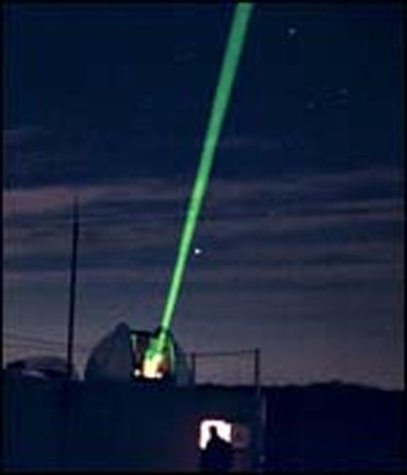
7 7 SLR DORIS
8 SLR Stations 8

9 DORIS stations 9
10 10 Quality of orbits The quality of orbits are measured by the reduction of crossover differences and by comparison to SLR stations TOPEX/Poseidon and Jason orbits are now good to the ~2-cm level ERS-2 and ENVISAT: ~3 cm more affected by drag, as in lower orbit, and much larger, than T/P and Jason
11 11 Topex/Poseidon Orbit Error Budget Size of observed error in orbit model, by parameter Gravity, 2.0 cm Radiation pressure, 2.0cm Atmospheric drag, 1.0 cm Geoid model, 1.0 cm Solid earth and ocean tide, 1.0 cm Troposphere, < 1 cm Station location, 1.0 cm Total radial orbit error, 3.5 cm Mission design specification, 12.8 cm With latest, state-of-art models, the above total orbit error decreases to ~2.0 cm
12 13 Atmospheric Corrections As the radar signal travels through the atmosphere it is slowed down w.r.t. speed of light in the vacuum Since we need speed to estimate range, we must correct for this effect. There are three parts of the atmosphere that must be taken into account Ionosphere Dry troposphere Wet troposphere
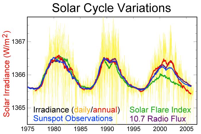
13 14 Ionospheric correction Caused by free electrons in the ionosphere Frequency dependent so it can be measured with a dual frequency altimeter: ERS-1/2 Topex Jason-1/2 Envisat (only up to 17/01/08) GFO Cryosat AltiKa Otherwise use a model or other observations from another dual frequency radar system (GPS, DORIS) Average value 45mm, s.d. 35mm Depends on solar cycle and time of day GIM (based on GPS, produced by JPL) is a good product to use for single-frequency altimeters
14 15

15 16 Typical Iono correction values (mm) Low solar activity High solar activity
16 17 Dry Tropospheric Correction Due to O 2 molecules in the atmosphere Derived from atmospheric pressure (from met models) by: Dry_trop = p ( cos(2 latitude) ) (mm) (hpa) Average value 2300 mm, s.d. 30 mm
 Standard")
17 18 Winter DJF Air Pressure Mean (hpa) Standard deviation
 Standard")
18 19 Summer JJA Atmospheric Pressure Mean (hpa) Standard Deviation
19 20 Wet Tropospheric Correction Caused by water vapour in the atmosphere Obtained by microwave radiometer on satellite two frequency on ERS-1/2 and Envisat three frequency on T/P and Jason-1/2 Or from weather forecasting models (ECMWF) Or (new!) from GPS measurements This is a difficult correction due to the high temporal and spatial variability of water vapour Average value 150 mm, s.d. ~50 mm
 Standard")
20 21 Tropospheric water vapour from SSM/I Mean (g/m 2 ) Standard deviation
21 22 Atmospheric corrections - summary Ionospheric correction: 2-20 cm [+/- 3 cm] Caused by presence of free electrons in the ionosphere Use model or measure using dual frequency altimeter Dry tropospheric correction: 2.3 m [+/- 1-2 cm] Caused by oxygen molecules Model the correction accurately using surface atmospheric pressure Wet tropospheric correction: 5-35 cm [+/- 3-6 cm] Caused by clouds and rain (variable) Measure H 2 O with microwave radiometer Or use weather model predictions
22 23 Sea State Bias Corrections Tracker bias Problem with tracking the pulse when the sea is rough Electromagnetic Bias Radar return from the troughs is stronger than from the crests First approx: empirical correction based on H s (~5%) mean surface least return from upper level most return from lower level Crests: Spiky surface, weaker back reflection Troughs: Flatter concave surface, stronger reflection
23 24 State of the art in sea state bias There is as yet no theoretical method for estimating the sea state bias. We are therefore forced to use empirical methods We find the function of H s (and U 10 - that is wind) that minimises the altimeter crossover differences or the differences w.r.t in situ observation (from wave buoys)

24 25 Parametric vs non-parametric With parametric methods we have a specified function for the SSB and estimate the parameters of this function, e.g. the BM4 model used for TOPEX Then we use the fitted function With non-parametric methods we compile statistics and smooth the resulting 2-d histogram Then we use the histogram as look-up table An example non-parametric SSB
25 Example of TOPEX Error Budget for 1-Hz 26 measurement (from Chelton et al 2001) Source Error Instrument Noise 1.7cm Ionosphere 0.5cm EM Bias 2.0cm Skewness 1.2cm Dry Troposphere 0.7cm Wet Troposphere 1.1cm Orbit 2.5cm Total 4.1cm

26 History of satellite altimetry accuracy in open ocean 100 fold improvement in 25 years! Now at ~2 cm level!! Courtesy of Lee-Lueng Fu., NASA

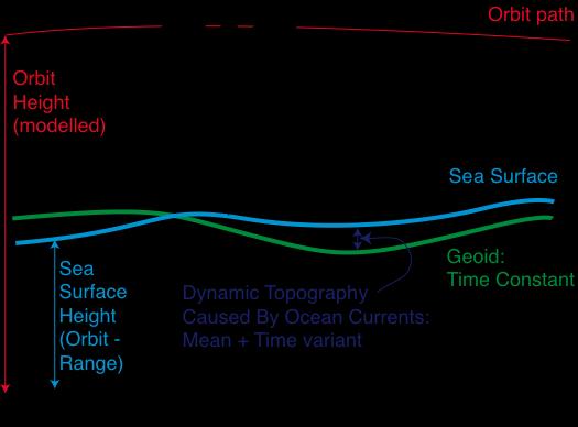
27 All the processing seen so far is to get a good SSH=orbit-range Next: what is there in the SSH?.
Exploiting radar power to study oceans and climate: the rise and prospects of satellite altimetry
 Exploiting radar power to study oceans and climate: the rise and prospects of satellite altimetry Paolo Cipollini National Oceanography Centre, Southampton, UK with contributions by Peter Challenor, Ian
Active microwave systems (2) Satellite Altimetry * the movie * applications
 Satellite Altimetry * the movie * applications") Remote Sensing: John Wilkin wilkin@marine.rutgers.edu IMCS Building Room 211C 732-932-6555 ext 251 Active microwave systems (2) Satellite Altimetry * the movie * applications Altimeters (nadir pointing
Remote Sensing: John Wilkin wilkin@marine.rutgers.edu IMCS Building Room 211C 732-932-6555 ext 251 Active microwave systems (2) Satellite Altimetry * the movie * applications Altimeters (nadir pointing
Presented at the FIG Congress 2018, May 6-11, 2018 in Istanbul, Turkey
 Presented at the FIG Congress 2018, May 6-11, 2018 in Istanbul, Turkey Paper ID: 9253 (Peer Review) By: Amalina Izzati Abdul Hamid, Ami Hassan Md Din & Kamaludin Mohd Omar Geomatic Innovation Research
Coastal Altimetry Workshop February 5-7, Supported by NOAA (Stan Wilson) NASA (Eric Lindstrom, Lee Fu)
 NASA (Eric Lindstrom, Lee Fu)") Coastal Altimetry Workshop February 5-7, 2008 Organized by: Laury Miller, Walter Smith: NOAA/NESDIS Ted Strub, Amy Vandehey: CIOSS/COAS/OSU With help from many of you! Supported by NOAA (Stan Wilson) NASA
Coastal Altimetry Workshop February 5-7, 2008 Organized by: Laury Miller, Walter Smith: NOAA/NESDIS Ted Strub, Amy Vandehey: CIOSS/COAS/OSU With help from many of you! Supported by NOAA (Stan Wilson) NASA
DERIVATION OF SEA LEVEL ANOMALY USING SATELLITE ALTIMETER. Ami Hassan Md Din, Kamaludin Mohd Omar
 DERIVATION OF SEA LEVEL ANOMALY USING SATELLITE ALTIMETER Ami Hassan Md Din, Kamaludin Mohd Omar Faculty of Geoinformation Science and Engineering Universiti Teknologi Malaysia Skudai, Johor E-mail: amihassan@utm.my
Satellite Oceanography and Applications 2: Altimetry, scatterometry, SAR, GRACE. RMU Summer Program (AUGUST 24-28, 2015)
") Satellite Oceanography and Applications 2: Altimetry, scatterometry, SAR, GRACE RMU Summer Program (AUGUST 24-28, 2015) Altimetry 2 Basic principles of satellite altimetry Altimetry: the measurements of
Satellite Oceanography and Applications 2: Altimetry, scatterometry, SAR, GRACE RMU Summer Program (AUGUST 24-28, 2015) Altimetry 2 Basic principles of satellite altimetry Altimetry: the measurements of
Thoughts on Sun-Synchronous* Altimetry
 Thoughts on Sun-Synchronous* Altimetry R. D. Ray NASA Goddard Space Flight Center 14 March 2007 * Yes, a sun-synchronous wide swath is still sun-synch! Whatʼs so bad about sun-synchronous altimetry? For
A short course on Altimetry
 A short course on Altimetry Paolo Cipollini National Oceanography Centre, Southampton, UK cipo@noc.soton.ac.uk with contributions by Peter Challenor, Ian Robinson, Helen Snaith, R. Keith Raney + some other
Comparison of Mean Sea Surface Data For Oceanography
 Universität Stuttgart Geodätisches Institut Comparison of Mean Sea Surface Data For Oceanography Studienarbeit im Studiengang Geodäsie und Geoinformatik an der Universität Stuttgart Naomi Zimmermann Stuttgart,
QUINC2. Harvest MNPEAK MCDON4 MAZTLN HOLLAS
 Orbit analysis for the TOPEX altimeter calibration P.N.A.M. Visser 1 and C.K. Shum University of Texas at Austin Center for Space Research October 1993 Abstract Several orbits have been used in the calibration
Near Real-Time Alongtrack Altimeter Sea Level Anomalies: Options. Corinne James and Ted Strub Oregon State University. Motivation
 Near Real-Time Alongtrack Altimeter Sea Level Anomalies: Options Corinne James and Ted Strub Oregon State University Motivation Modelers want easy access to alongtrack SSHA, SLA or ADT, with enough explanations
New retrieval algorithm for the wet tropospheric correction of altimetry missions
 New retrieval algorithm for the wet tropospheric correction of altimetry missions A. Rahmani, E. Obligis and L. Eymard CLS/LOCEAN MicroRad Conference March 2008 Page n 1/13 Introduction Altimeters are
Processing RADS Data LAXMIKANT DHAGE COAS OREGON STATE UNIVERSITY
 Processing RADS Data LAXMIKANT DHAGE COAS OREGON STATE UNIVERSITY 1 Declaration I hereby declare that the work incorporated in this project is original and carried out at the College of Oceanic and Atmospheric
1 The satellite altimeter measurement
 1 The satellite altimeter measurement In the ideal case, a satellite altimeter measurement is equal to the instantaneous distance between the satellite s geocenter and the ocean surface. However, an altimeter
Geophysical Correction Application in Level 2 CryoSat Data Products
 ESRIN-EOP-GQ / IDEAS IDEAS-VEG-IPF-MEM-1288 Version 2.0 29 July 2014 Geophysical Correction Application in Level 2 CryoSat Data Products TABLE OF CONTENTS 1 INTRODUCTION... 3 1.1 Purpose and Scope... 3
Remote Sensing I: Basics
 Remote Sensing I: Basics Kelly M. Brunt Earth System Science Interdisciplinary Center, University of Maryland Cryospheric Science Laboratory, Goddard Space Flight Center kelly.m.brunt@nasa.gov (Based on
COMBINING ALTIMETRY AND HYDROGRAPHY FOR GEODESY
 COMBINING ALTIMETRY AND HYDROGRAPHY FOR GEODESY Helen M. Snaith, Peter G. Challenor and S Steven G. Alderson James Rennell Division for Ocean Circulation and Climate, Southampton Oceanography Centre, European
EUMETSAT STATUS AND PLANS
 1 EUM/TSS/VWG/15/826793 07/10/2015 EUMETSAT STATUS AND PLANS François Montagner, Marine Applications Manager, EUMETSAT WMO Polar Space Task Group 5 5-7 October 2015, DLR, Oberpfaffenhofen PSTG Strategic
HY-2A Satellite User s Guide
 National Satellite Ocean Application Service 2013-5-16 Document Change Record Revision Date Changed Pages/Paragraphs Edit Description i Contents 1 Introduction to HY-2 Satellite... 1 2 HY-2 satellite data
Sentinel-3A Product Notice STM L2 Marine (NRT, STC and NTC)
") Sentinel-3A Product Notice STM L2 Marine (NRT, STC and NTC) Mission Sensor Product S3-A SRAL/MWR L2 NRT STC and NTC (Marine Products) Product Notice ID S3A.PN-STM-L2M.01 EUM/OPS-SEN3/DOC/16/893228 Issue
Sentinel-3A Product Notice STM L2 Marine (NRT, STC and NTC) Mission Sensor Product S3-A SRAL/MWR L2 NRT STC and NTC (Marine Products) Product Notice ID S3A.PN-STM-L2M.01 EUM/OPS-SEN3/DOC/16/893228 Issue
S3 Product Notice Altimetry
 S3 Product Notice Altimetry Mission Sensor Product S3-A SRAL / MWR LAND L2 NRT, STC and NTC Product Notice ID Issue/Rev Date Version 1.0 Preparation S3A.PN-STM-L2L.06 04-April-2018 This Product Notice
Supplementary material to Challenges in Coastal Satellite Radar Altimetry
 Supplementary material to Challenges in Coastal Satellite Radar Altimetry Published 30 June 2009 Jérôme Benveniste, European Space Agency Center for Earth Observation (ESRIN), Frascati, Italy Stefano Vignudelli,
Jason-1 orbit comparison : POE-E versus POE-D. L. Zawadzki, M. Ablain (CLS)
") Jason-1 orbit comparison : versus POE-D L. Zawadzki, M. Ablain (CLS) Jason-1 orbit comparison : versus POE-D Objectives Evaluate orbit for Jason-1 (by comparison to POE-D standard) Observe and analyse
Jason-1 orbit comparison : versus POE-D L. Zawadzki, M. Ablain (CLS) Jason-1 orbit comparison : versus POE-D Objectives Evaluate orbit for Jason-1 (by comparison to POE-D standard) Observe and analyse
Satellite ALTimetry. SALT applications and use of data base for SE-Asia region. SEAMERGES kick-off meeting, Bangkok, Thailand.
 Satellite ALTimetry SALT applications and use of data base for SE-Asia region SEAMERGES kick-off meeting, Bangkok, Thailand Marc Naeije 4 March 2004 1 Faculty of Aerospace Engineering DEOS/AS SEAMERGES
Status of Precise Orbit Determination for Altimeter Satellites at GSFC
 Status of Precise Orbit Determination for Altimeter Satellites at GSFC F.G. Lemoine 1, N.P. Zelensky 2, D.S. Chinn 2, B.D. Beckley 2, D.E.Pavlis 2 (1) NASA GSFC, Greenbelt, Maryland, USA (2) SGT Inc.,
Satellite Altimetry for Geodesy, Geophysics and Oceanography
 International Association of Geodesy Symposia 1 Satellite Altimetry for Geodesy, Geophysics and Oceanography Proceedings of the International Workshop on Satellite Altimetry, a joint workshop of IAG Section
ON THE ACCURACY OF CURRENT MEAN SEA SURFACE MODELS FOR THE USE WITH GOCE DATA
 ON THE ACCURACY OF CURRENT MEAN SEA SURFACE MODELS FOR THE USE WITH GOCE DATA Ole B. Andersen 1, M-.H., Rio 2 (1) DTU Space, Juliane Maries Vej 30, Copenhagen, Denmark (2) CLS, Ramon St Agne, France ABSTRACT
Coastal Altimetry Data Handbook Issue 2.0, 02 September 2014
 Coastal Altimetry Data Handbook Issue 2.0, 02 September 2014 Edited by the Coastal & Marine Research Centre, University College Cork DOCUMENT DETAILS Author Paolo Cipollini, Rory Scarrott, Helen Snaith
AN ASSESSMENT OF SATELLITE ALTIMETRY IN PROXIMITY OF THE MEDITERRANEAN COASTLINE
 AN ASSESSMENT OF SATELLITE ALTIMETRY IN PROXIMITY OF THE MEDITERRANEAN COASTLINE Fenoglio-Marc L. (1), Vignudelli S. (2), Humbert A. (1), Cipollini P. (3), Fehlau M. (1), Becker M. (1) (1) Institut für
Electromagnetic bias estimates based on TOPEX, buoy, and wave model data
 JOURNAL OF GEOPHYSICAL RESEARCH, VOL. 108, NO. C11, 3351, doi:10.1029/2002jc001525, 2003 Electromagnetic bias estimates based on TOPEX, buoy, and wave model data Raj Kumar Oceanic Sciences Division, MOG/RESA,
Cryosat-2 SAR altimetry processing and use in the Arctic Ocean. Ole Andersen, M. Jain & Lars Stenseng
 Cryosat-2 SAR altimetry processing and use in the Arctic Ocean Ole Andersen, M. Jain & Lars Stenseng Context We investigate satellite altimetry in the Arctic Ocean for 1) Studies of long term changes 2)
The impact of the assimilation of altimeters and ASAR L2 wave data in the wave model MFWAM
 The impact of the assimilation of altimeters and ASAR L2 wave data in the wave model MFWAM Lotfi Aouf 1, Jean-Michel Lefèvre 1 1) Météo-France, Toulouse 12 th Wave Hindcasting and Forecasting, Big Island
Sentinel-3A Product Notice STM L2 Marine ( Spring-2018 Reprocessing Campaign )
") Sentinel-3A Product Notice STM L2 Marine ( Spring-2018 Reprocessing Campaign ) Mission Sensor Product S3-A SRAL/MWR L2 NTC (Marine Reprocessed Dataset from Spring-2018 Reprocessing Campaign ) Product Notice
Sentinel-3A Product Notice STM L2 Marine ( Spring-2018 Reprocessing Campaign ) Mission Sensor Product S3-A SRAL/MWR L2 NTC (Marine Reprocessed Dataset from Spring-2018 Reprocessing Campaign ) Product Notice
A Mission to Planet Mars Gravity Field Determination
 A Mission to Planet Mars Gravity Field Determination Department for Theoretical Geodesy Graz University of Technology and Space Research Institute Austrian Academy of Sciences Gravity field CHAMP GRACE
Radio Frequency Earth Science
 Radio Frequency Earth Science Overview for Committee On Radio Frequency (CORF) National Academy of Science National Research Council April 27, 2005 Bill.Watson@NASA.Gov Program Executive for Ground Networks
Status of Indian Satellite Meteorological Programme
 Status of Indian Satellite Meteorological Programme Pradeep K Thapliyal Space Applications Centre (SAC) Indian Space research Organisation (ISRO) Ahmedabad (INDIA) Email: pkthapliyal@sac.isro.gov.in International
D2.1 Product Validation Plan (PVP)
") Consortium Members ESA Sea Level CCI D2.1 Product Validation Plan (PVP) Reference: Nomenclature: CLS-DOS-NT-10-278 SLCCI-PVP-005 Issue: 1. 1 Date: Oct. 11, 11 CLS-DOS-NT-10-278 SLCCI-PVP-005 Issue 1.1
Consortium Members ESA Sea Level CCI D2.1 Product Validation Plan (PVP) Reference: Nomenclature: CLS-DOS-NT-10-278 SLCCI-PVP-005 Issue: 1. 1 Date: Oct. 11, 11 CLS-DOS-NT-10-278 SLCCI-PVP-005 Issue 1.1
Improving the long-term stability of the GDR orbit solutions
 Improving the long-term stability of the GDR orbit solutions L. Cerri 1, A. Couhert 1, S. Houry 1, F. Mercier 1 (1) CNES Toulouse OSTST Meeting 19-21 Oct. 2011 POD Splinter Session Status of the POD standards
Course outline, objectives, workload, projects, expectations
 Course outline, objectives, workload, projects, expectations Introductions Remote Sensing Overview Elements of a remote sensing observing system 1. platform (satellite, surface, etc) 2. experimental design
REVISION OF THE STATEMENT OF GUIDANCE FOR GLOBAL NUMERICAL WEATHER PREDICTION. (Submitted by Dr. J. Eyre)
") WORLD METEOROLOGICAL ORGANIZATION Distr.: RESTRICTED CBS/OPAG-IOS (ODRRGOS-5)/Doc.5, Add.5 (11.VI.2002) COMMISSION FOR BASIC SYSTEMS OPEN PROGRAMME AREA GROUP ON INTEGRATED OBSERVING SYSTEMS ITEM: 4 EXPERT
WORLD METEOROLOGICAL ORGANIZATION Distr.: RESTRICTED CBS/OPAG-IOS (ODRRGOS-5)/Doc.5, Add.5 (11.VI.2002) COMMISSION FOR BASIC SYSTEMS OPEN PROGRAMME AREA GROUP ON INTEGRATED OBSERVING SYSTEMS ITEM: 4 EXPERT
New satellite mission for improving the Terrestrial Reference Frame: means and impacts
 Fourth Swarm science meeting and geodetic missions workshop ESA, 20-24 March 2017, Banff, Alberta, Canada New satellite mission for improving the Terrestrial Reference Frame: means and impacts Richard
Nanosats for Radar Altimetry
 SSC15-XII-7 Nanosats for Radar Altimetry Austin Mroczek Program Executive Office Space Systems / SPAWAR Systems Center Pacific 4301 Pacific Highway, San Diego, CA 92110; (619) 221-7749 austin.mroczek@navy.mil
Recovering climate-quality coastal sea level measurements from satellite altimetry!
 UK Sea Level Meeting 215 In honour of Philip Woodworth! Liverpool 12-13 March 215! Recovering climate-quality coastal sea level measurements from satellite altimetry! Francisco M. Calafat 1, Paolo Cipollini
Study of Sea Level Variation of Exclusive Economic Zone of Malaysia. Universiti Teknologi Malaysia Skudai, Johor
 Study of Sea Level Variation of Exclusive Economic Zone of Malaysia Kamaludin Omar 1, Shahrum Ses 1, Marc Naeije 2, Mohamad Asrul Mustafar 1 1 Faculty of Geoinformation Science and Engineering Universiti
Characteristics of the Atmosphere
 Characteristics of the Atmosphere * The atmosphere is a mixture of gases that surrounds the Earth. * It contains oxygen and protects us from the sun's ultraviolet rays. * The atmosphere has 78% Nitrogen,
Coastal Altimetry: recent developments and proposed use in the Agulhas region. Paolo Cipollini (NOCS, UK)
") Coastal Altimetry: recent developments and proposed use in the Agulhas region Paolo Cipollini (NOCS, UK) Coastal altimetry - the concept Satellite altimetry has been designed for the open ocean 15 years
Coastal Altimetry: recent developments and proposed use in the Agulhas region Paolo Cipollini (NOCS, UK) Coastal altimetry - the concept Satellite altimetry has been designed for the open ocean 15 years
Inter-tropical Convergence Zone (ITCZ) analysis using AIRWAVE retrievals of TCWV from (A)ATSR series and potential extension of AIRWAVE to SLSTR
 analysis using AIRWAVE retrievals of TCWV from (A)ATSR series and potential extension of AIRWAVE to SLSTR") Inter-tropical Convergence Zone (ITCZ) analysis using AIRWAVE retrievals of TCWV from (A)ATSR series and potential extension of AIRWAVE to SLSTR Enzo Papandrea (SERCO, CNR-ISAC, Enzo.Papandrea@serco.com)
Inter-tropical Convergence Zone (ITCZ) analysis using AIRWAVE retrievals of TCWV from (A)ATSR series and potential extension of AIRWAVE to SLSTR Enzo Papandrea (SERCO, CNR-ISAC, Enzo.Papandrea@serco.com)
S3-A Land and Sea Ice Cyclic Performance Report. Cycle No Start date: 21/04/2017. End date: 18/05/2017
 PREPARATION AND OPERATIONS OF THE MISSION PERFORMANCE CENTRE (MPC) FOR THE COPERNICUS SENTINEL-3 MISSION Cycle No. 017 Start date: 21/04/2017 End date: 18/05/2017 Ref. S3MPC.UCL.PR.08-017 Contract: 4000111836/14/I-LG
THE FUTURE ROLE OF SATELLITE ALTIMETRY EARLY RECOMMENDATIONS FROM THE GAMBLE PROJECT.
 THE FUTURE ROLE OF SATELLITE ALTIMETRY EARLY RECOMMENDATIONS FROM THE GAMBLE PROJECT. P.D. Cotton 1, Yves Menard 2, and the GAMBLE Project Team 1 Satellite Observing Systems 15, Church Street, Godalming,
CryoSat Monthly Quality Report #93
 9th May 2018-7th June 2018 Author(s): CryoSat Quality Control Team (Telespazio UK) IDEAS+-VEG-OQC-REP-2987 17 July 2018 AMENDMENT RECORD SHEET The Amendment Record Sheet below records the history and issue
OSTST Proposed splinters
 1. Proposed splinters OSTST 2018 This list will be used for the splinter selection in the abstract submission process Application development for Operations Instrument Processing 1. Instrument Processing:
esurge A Storm Surge Demonstration Project
 esurge A Storm Surge Demonstration Project Helen Snaith British Oceanographic Data Centre, National Oceanography Centre, UK The Impact of Storm Surges Great flood in the Netherlands History: Zeeland, 31
Sentinels and Waves. GMES Sentinel-1 SAR GMES Sentinel-3 Altimeter
 Sentinels and Waves GMES Sentinel-1 SAR GMES Sentinel-3 Altimeter Simon Pinnock, ESA-ESRIN, Frascati, Italy with help from Craig Donlon (ESTEC) & Nuno Miranda (ESRIN) et al. GMES Space Component: dedicated
Assessment of the orbit-related sea level error budget for the TOPEX/Poseidon altimetry mission
 Assessment of the orbit-related sea level error budget for the TOPEX/Poseidon altimetry mission Sergei Rudenko (1,2), Saskia Esselborn (1), Tilo Schöne (1) (1) GFZ German Research Centre for Geosciences,
Sentinel 3A Product Notice STM L2 Marine
 Sentinel 3A Product Notice STM L2 Marine Mission Sensor Product S3 A SRAL/MWR L2 NRT, STC and NTC (Marine Products) Product Notice ID EUM/OPS SEN3/DOC/16/893228 Issue Date 23 March 2018 Version Preparation
The Malaysian Seas: Variation of Sea Level Observed by Tide Gauges and Satellite Altimetry. Universiti Teknologi Malaysia Skudai, Johor
 The Malaysian Seas: Variation of Sea Level Observed by Tide Gauges and Satellite Altimetry Kamaludin Omar 1, Shahrum Ses 1, Marc Naeije 2, Mohamad Asrul Mustafar 1 1 Faculty of Geoinformation Science and
The KMS04 Multi-Mission Mean Sea Surface.
 The KMS04 Multi-Mission Mean Sea Surface. Ole B. Andersen, Anne L. Vest and P. Knudsen Danish National Space Center. Juliane Maries Vej 30, DK-100 Copenhagen, Denmark. Email: {oa,alv,pk}@spacecenter.dk,
The Earth Explorer Missions - Current Status
 EOQ N 66 July 2000 meteorology earthnet remote sensing solid earth future programmes Earth Observation Quarterly The Earth Explorer Missions - Current Status G. Mégie (1) and C.J. Readings (2) (1) Institut
Earth Exploration-Satellite Service (EESS)- Active Spaceborne Remote Sensing and Operations
- Active Spaceborne Remote Sensing and Operations") Earth Exploration-Satellite Service (EESS)- Active Spaceborne Remote Sensing and Operations SRTM Radarsat JASON Seawinds TRMM Cloudsat Bryan Huneycutt (USA) Charles Wende (USA) WMO, Geneva, Switzerland
Earth Exploration-Satellite Service (EESS)- Active Spaceborne Remote Sensing and Operations SRTM Radarsat JASON Seawinds TRMM Cloudsat Bryan Huneycutt (USA) Charles Wende (USA) WMO, Geneva, Switzerland
Lionel Zawadzki 1, Michaël Ablain 1, Loren Carrere 1, Richard D. Ray 2, Nikita P. Zelensky 3, Florent Lyard 4, Amandine Guillot 5, Nicolas Picot 5
 Ocean Sci. Discuss., doi:.194/os-16-19, 16 Published: 2 May 16 Reduction of the 9 -day error signal in the Mean Sea Level derived from TOPEX/Poseidon, Jason-1 and Jason-2 data with the latest FES and GOT
Spectral Albedos. a: dry snow. b: wet new snow. c: melting old snow. a: cold MY ice. b: melting MY ice. d: frozen pond. c: melting FY white ice
 Spectral Albedos a: dry snow b: wet new snow a: cold MY ice c: melting old snow b: melting MY ice d: frozen pond c: melting FY white ice d: melting FY blue ice e: early MY pond e: ageing ponds Extinction
S3-A Land and Sea Ice Cyclic Performance Report. Cycle No Start date: 30/09/2017. End date: 27/10/2017
 PREPARATION AND OPERATIONS OF THE MISSION PERFORMANCE CENTRE (MPC) FOR THE COPERNICUS SENTINEL-3 MISSION Start date: 30/09/2017 End date: 27/10/2017 Ref. S3MPC.UCL.PR.08-023 Contract: 4000111836/14/I-LG
52 th International Astronautical Congress 1-5 Oct 2001 / Toulouse, France
 IAF 01 B.2.10 ALTIKA : A MICRO-SATELLITE Ka-BAND ALTIMETRY MISSION J. VERRON 1, P. BAHUREL 2, E. CAUBET 3, B. CHAPRON 4, J.F. CRETAUX 5, L. EYMARD 6, C. LE PROVOST 5, P.Y. LE TRAON 7, L. PHALIPPOU 3, F.
Updated Results from the In Situ Calibration Site in Bass Strait, Australia
 Updated Results from the In Situ Calibration Site in Bass Strait, Australia Christopher Watson 1, Neil White 2,, John Church 2 Reed Burgette 1, Paul Tregoning 3, Richard Coleman 4 1 University of Tasmania
Lecture: Inland Altimetry I
 Lecture: Inland Altimetry I Denise Dettmering (with contributions from W.Bosch, C.Schwatke, and E. Börgens) 1 Deutsches Geodätisches Forschungsinstitut (DGFI) München, Germany email: dettmering@dgfi.badw.de
Atmospheric Water Vapor and Geoid Measurements in the Open Ocean with GPS
 Atmospheric Water Vapor and Geoid Measurements in the Open Ocean with GPS Christian Rocken, James Johnson, Teresa Van Hove, Tetsuya Iwabuchi COSMIC Program Office, University Corporation for Atmospheric
EVALUATION OF WINDSAT SURFACE WIND DATA AND ITS IMPACT ON OCEAN SURFACE WIND ANALYSES AND NUMERICAL WEATHER PREDICTION
 5.8 EVALUATION OF WINDSAT SURFACE WIND DATA AND ITS IMPACT ON OCEAN SURFACE WIND ANALYSES AND NUMERICAL WEATHER PREDICTION Robert Atlas* NOAA/Atlantic Oceanographic and Meteorological Laboratory, Miami,
NSIDC Distributed ICESat GLAS Laser Operations Periods: Latest Release
 Notes Laser 1A Laser 1B Laser 2A Laser 2A Laser 2A Laser 2B Laser 2C Laser 3A Laser 3B Laser 3C Laser 3D Laser 3E Laser 3F Laser 3G Laser 3H Laser 3I Laser 3J Laser 3K Laser 2D Laser 2E Laser 2F NSIDC
Report from CNSA 16th GSICS Executive Panel, Boulder, May 2015
 Report from CNSA 16th GSICS Executive Panel, Boulder, 15-16 May 2015 Peng Zhang, Jun Gao Satellite Introdution GF-1 satellite mission GF-1 satellite is the first CHEOS constellation satellite launched
Earth-Oriented Space Research at TU-Delft
 Earth-Oriented Space Research at TU-Delft The contribution of DEOS to the South-East Asia: Mastering Environmental Research with Geodetic Space Techniques (SEAMERGES) project Kick-off meeting, Chulalongkorn
Lesson IV. TOPEX/Poseidon Measuring Currents from Space
 Lesson IV. TOPEX/Poseidon Measuring Currents from Space The goal of this unit is to explain in detail the various measurements taken by the TOPEX/Poseidon satellite. Keywords: ocean topography, geoid,
Satellite Geodesy and Navigation Present and Future
 Satellite Geodesy and Navigation Present and Future Drazen Svehla Institute of Astronomical and Physical Geodesy Technical University of Munich, Germany Content Clocks for navigation Relativistic geodesy
Your web browser (Safari 7) is out of date. For more security, comfort and the best experience on this site: Update your browser Ignore
 is out of date. For more security, comfort and the best experience on this site: Update your browser Ignore") Your web browser (Safari 7) is out of date. For more security, comfort and the best experience on this site: Update your browser Ignore ALTIMETER altitude meter For the complete encyclopedic entry with
Your web browser (Safari 7) is out of date. For more security, comfort and the best experience on this site: Update your browser Ignore ALTIMETER altitude meter For the complete encyclopedic entry with
Overview of data assimilation in oceanography or how best to initialize the ocean?
 Overview of data assimilation in oceanography or how best to initialize the ocean? T. Janjic Alfred Wegener Institute for Polar and Marine Research Bremerhaven, Germany Outline Ocean observing system Ocean
Geodetics measurements within the scope of current and future perspectives of GNSS-Reflectometry and GNSS-Radio Occultation
 Geodetics measurements within the scope of current and future perspectives of GNSS-Reflectometry and GNSS-Radio Occultation Introduction The aim of this presentation is to provide an overview of the GNSS-R
Remote Sensing in Meteorology: Satellites and Radar. AT 351 Lab 10 April 2, Remote Sensing
 Remote Sensing in Meteorology: Satellites and Radar AT 351 Lab 10 April 2, 2008 Remote Sensing Remote sensing is gathering information about something without being in physical contact with it typically
The ICESat 2 Mission Laser altimetry of ice, clouds and land elevation
 OSTM SWT San Diego October 2011 The ICESat 2 Mission Laser altimetry of ice, clouds and land elevation and also ocean, coastal, and continental waters Charon Birkett, ESSIC/UMD on behalf of T. Markus,
Climate & Earth System Science. Introduction to Meteorology & Climate. Chapter 05 SOME OBSERVING INSTRUMENTS. Instrument Enclosure.
 Climate & Earth System Science Introduction to Meteorology & Climate MAPH 10050 Peter Lynch Peter Lynch Meteorology & Climate Centre School of Mathematical Sciences University College Dublin Meteorology
Evaluation of radar altimeter path delay using ECMWF pressure-level and model-level fields
 Evaluation of radar altimeter path delay using ECMWF pressure-level and model-level fields Author: Saleh Abdalla A report for ESA contract 21519/ 08/ I-OL (CCN2) Series: ECMWF - ESA Contract Report A full
Effects of Unresolved High-Frequency Signals in Altimeter Records Inferred from Tide Gauge Data
 534 JOURNAL OF ATMOSPHERIC AND OCEANIC TECHNOLOGY VOLUME 19 Effects of Unresolved High-Frequency Signals in Altimeter Records Inferred from Tide Gauge Data RUI M. PONTE Atmospheric and Environmental Research,
Remote Sensing and GIS. Microwave Remote Sensing and its Applications
 Subject Paper No and Title Module No and Title Module Tag Geology Remote Sensing and GIS Microwave Remote Sensing and its Applications RS & GIS XVII Principal Investigator Co-Principal Investigator Co-Principal
2 nd Tidal and Water Level Working Group Meeting
 2 nd Tidal and Water Level Working Group Meeting Norwegian Hydrographic Service, Stavanger, Norway 27 29 April 2010 Vertical Offshore Reference Framework (VORF) Chris Jones United Kingdom Hydrographic
FRENCH TRANSPORTABLE LASER RANGING STATION: POSITIONING CAMPAIGNS FOR SATELLITE ALTIMETER CALIBRATION MISSIONS IN OCCIDENTAL MEDITERRANEAN SEA
 Larhyss Journal, ISSN 1112-3680, n 12, Janvier 2013, pp. 57-69 2013 Tous droits réservés FRENCH TRANSPORTABLE LASER RANGING STATION: POSITIONING CAMPAIGNS FOR SATELLITE ALTIMETER CALIBRATION MISSIONS IN
A Unique Reference Frame: Basis of the Global Geodetic Observing System (GGOS) for Geodynamics and Global Change
 for Geodynamics and Global Change") SRTM (InSAR) A Unique Reference Frame: Basis of the Global Geodetic Observing System (GGOS) for Geodynamics and Global Change Hermann Drewes President IAG Commission 1 Reference Frames Deutsches Geodätisches
SRTM (InSAR) A Unique Reference Frame: Basis of the Global Geodetic Observing System (GGOS) for Geodynamics and Global Change Hermann Drewes President IAG Commission 1 Reference Frames Deutsches Geodätisches
OSE/OSSEs at NOAA. Eric Bayler NOAA/NESDIS/STAR
 OSE/OSSEs at NOAA Eric Bayler NOAA/NESDIS/STAR OSE/OSSEs at NOAA NOAA Leadership view: Relatively inexpensive way to: Assess the impact of potential new observations Refine and redirect current observing
Towards an improved ILRS TRF contribution
 Towards an improved ILRS TRF contribution Erricos C. Pavlis ILRS Analysis Coordinator JCET/ & NASA Goddard IERS Workshop on Conventions 2007 20-21 Sept. 2007, Sèvres, France Overview The ILRS Network Geometry
SCOOP. SAR Altimetry Coastal and Open Ocean Performance. Product Validation Plan D2.4
 SCOOP SAR Altimetry Coastal and Open Ocean Performance Product Validation Plan D2.4 Sentinel 3 For Science SAR Altimetry Studies SEOM Study 2. Coastal Zone and Open Ocean Study ESA Contract 4000115382/15/I-BG
Atmospheric Effects in Space Geodesy
 Atmospheric Effects in Space Geodesy Johannes Böhm 18 November 2011 @ UNESP, Presidente Prudente, Brazil The atmosphere.. is not only causing troubles in space geodesy.. but it opens up a wide field of
Observations of Arctic snow and sea ice thickness from satellite and airborne surveys. Nathan Kurtz NASA Goddard Space Flight Center
 Observations of Arctic snow and sea ice thickness from satellite and airborne surveys Nathan Kurtz NASA Goddard Space Flight Center Decline in Arctic sea ice thickness and volume Kwok et al. (2009) Submarine
TECH NOTE. New Mean Sea Surface for the CryoSat-2 L2 SAR Chain. Andy Ridout, CPOM, University College London
 TECH NOTE Subject : From : To : New Mean Sea Surface for the CryoSat-2 L2 SAR Chain Andy Ridout, CPOM, University College London Tommaso Parrinello, CryoSat Mission Manager, ESRIN Date : 30 th June 2014
GEOSC/METEO 597K Kevin Bowley Kaitlin Walsh
 GEOSC/METEO 597K Kevin Bowley Kaitlin Walsh Timeline of Satellites ERS-1 (1991-2000) NSCAT (1996) Envisat (2002) RADARSAT (2007) Seasat (1978) TOPEX/Poseidon (1992-2005) QuikSCAT (1999) Jason-2 (2008)
PREDICTION AND MONITORING OF OCEANIC DISASTERS USING MICROWAVE REMOTE SENSING TECHNIQUES
 PREDICTION AND MONITORING OF OCEANIC DISASTERS USING MICROWAVE REMOTE SENSING TECHNIQUES O P N Calla International Centre for Radio Science, OM NIWAS A-23, Shastri Nagar, Jodhpur-342 003 Abstract The disasters
CEOS and Climate monitoring
 CEOS and Climate monitoring Committee on Earth Observation Satellites www.ceos.org Climate challenges and the need for observations Observations play a crucial role in the detection of climate change and
Unit 5 Lesson 3 How is Weather Predicted? Copyright Houghton Mifflin Harcourt Publishing Company
 Tracking the Weather Warm up 1 Why is it important to watch the weather forecast before traveling to another country? Tracking the Weather A meteorologist is a scientist who studies weather. Meteorologists
Analysis of Doppler signals from nadir altimeters over ocean. F. Boy (CNES)
") Analysis of Doppler signals from nadir altimeters over ocean F. Boy (CNES) Delay-Doppler Phase Altimetry of Radar Altimeter Pulses Launched in 2016, Sentinel-3A has been measuring oceans, land, ice to
Analysis of Doppler signals from nadir altimeters over ocean F. Boy (CNES) Delay-Doppler Phase Altimetry of Radar Altimeter Pulses Launched in 2016, Sentinel-3A has been measuring oceans, land, ice to
1. CLIMATOLOGY: 2. ATMOSPHERIC CHEMISTRY:
 What is meteorology? A. METEOROLOGY: an atmospheric science that studies the day to day changes in the atmosphere 1. ATMOSPHERE: the blanket of gas that surrounds the surface of Earth; the air 2. WEATHER:
Remote Sensing Observations AOSC 200 Tim Canty
 Remote Sensing Observations AOSC 200 Tim Canty Class Web Site: http://www.atmos.umd.edu/~tcanty/aosc200 Topics for today: Maps Radar Satellite Observations Lecture 04 Feb 7 2019 1 Today s Weather Map http://www.wpc.ncep.noaa.gov/sfc/namussfcwbg.gif
High resolution geoid from altimetry & bathymetry: requirements for a future mission
 High resolution geoid from altimetry & bathymetry: requirements for a future mission The GRAL team: J-Y Royer 1,2, M-F Lalancette 3, G Louis 1,2, M Maia 1,2, D Rouxel 3 & L Géli 4 Project funded by 1 2
CRYOSAT CYCLIC REPORT
 CRYOSAT CYCLIC REPORT CYCLE #14 12TH NOVEMBER 2011 11TH DECEMBER 2011 Prepared by/ préparé par CryoSat IDEAS Team Reference/ réference Issue/ édition 1 Revision/ révision 0 Date of issue/ date d édition
SLR-based orbit determination and orbit prediction of space debris objects
 Geodätische Woche Congress Center Essen, 8.- 10. Oktober 2013 SLR-based orbit determination and orbit prediction of space debris objects Harald Wirnsberger, Oliver Baur, Georg Kirchner Space Research Institute