Community Participation in Land Governance Through Citywide Community Mapping GLTN Learning Exchange, Bayview Hotel, Manila November 7, 2017
|
|
|
- Benedict McGee
- 5 years ago
- Views:
Transcription

1 Community Participation in Land Governance Through Citywide Community Mapping GLTN Learning Exchange, Bayview Hotel, Manila November 7, 2017 Community-Led, Citywide Settlement Profiling and Mapping as Evidence-Based Approach To Land Governance: T h e C a s e O f M u n t i n l u p a C i t y, P h i l i p p i n e s
 16")
 estimated that a")
 44.")
2 I. Project Background Metro Manila the Philippines National Capital Region (NCR) 16 cities, 1 municipality In 2010, Metro Manila Development Authority (MMDA) estimated that a total of 556,526 informal settler families (ISFs) 44.% of total population is urbanized (2015)* data.worldbank.org


3 The Informal Settlements No security of tenure Lack of basic infrastructure Limited access to capital Mostly vulnerable to natural hazards and high risk areas Oplan Likas an initiative of the government to move 104,000 ISFs from high risk areas using half a billion pesos. After three and a half years only 20,000 units were built Factors: Lack of affordable land & housing Land constraints The Housing and Urban Development Coordinating Council estimated a 1.7 million housing backlog in Metro Manila in 2016 Challenge: The magnitude of the problem renders the traditional projectbased approach ineffectual. There is an urgent need to shift from project-based to programmatic approach to reach scale in a timely manner.


4 CITYWIDE COMMUNITY UPGRADING STRATEGY (2015) (also known as CDA or Citywide Development Approach to Informal Settlements Upgrading) A multi-stakeholder collaboration Key features: 1. Citywide in scope as it maps out all informal settlements in families in the area; 2. Community-led; 3. A partnership among city stakeholders; 4. Coordinated by the local or city government; 5. A citywide pooling of funds mobilized from various sources; and 6. An integration of solutions to land and housing problems with strategies to improve the socioeconomic status of the ISFs.


5 Muntinlupa City located in the southernmost part of Metro Manila and has a 11km Laguna de Bay shoreline. Accessible to Manila Central Business District in approximately one hour, it houses many commercial establishments and luxurious residential complexes nearly half of Muntinlupa s 460,000 residents belong to the urban poor sector. Based on 2007 LGU data, Muntinlupa has over 27,000 ISFsin 241 ISF communities scattered across 9 barangays. LGU prioritizes 9,000 ISF living in waterways and along the Lakeshore SUCAT BULI CUPANG ALABANG 4 BARANGAYS AS PILOT FOR CITYWIDE DEVELOPMENT APPROACH
6 The project deliverables include: 1. Collection of secondary data and provide analysis on housing needs and available resources; 2. Conduct of orientation and training of local government units (LGUs), communities, non-government organizations (NGOs) and people s organizations (POs) on community mapping and profiling; 3. Collection of primary data through community mapping and profiling in four (4) barangays in District II; 4. Encoding, analysis and validation gathered data; 5. Conduct of savings orientation, initiate network formation through barangay shelter development planning; 6. Consolidation of barangay shelter development plans into citywide shelter development plan; and 7. Prioritization of community housing project design and development.


7 Part II: Planning Approach and Framework Monitoring and Evaluation Participatory Planning Community-led Implementation PARTICIPATION Inclusion and Partnership Learning and Action Adaptation and Sustainability Participatory Assessment Community management and evaluation Capacitybuilding and Organizing


8 Data Collection Courtesy Calls Barangay Assembly Settlements Profiling - Visit to barangay local govt - Establish initial partnership and engagement - Formalize mapping activities with the settlements in their barangay - Orientation of the organized and non-organized communities in the barangay - Introduction and initial mapping with key leaders of the communities - This is done during the Barangay assembly - Preliminary identification of Settlements and basic information of the settlements (i.e. population, boundaries, issues, leadership status - Identify pilot communities


9 Data Collection Area Visits Spot Mapping Scaling and Structure Mapping - assess initial site conditions - identifying land marks - locating boundaries using GPS device - strcuture identification using base maps prepared after the ocular visit - confirmation of information like use and type of structure, no. of occupants, etc. - measuring of houses and translating them into the maps using color-coded papers -FGDs are organized for completion and validation of Settlements Profile - household level surveys


10 Data Analysis Consolidation of Primary and Secondary Data - Encoding and digitization of all primary and secondary data using Windows Excel, Google Earth, AutoCAD and STDM - Information collected was categorized into base data, demographic, social and organizational data, and spatial and physical data Presentation and Validation of Data - The consolidated and digitized data are now then presented and validated in an activity participated by the Barangay LGU, the communities, etc. - Using the Situational Analysis and Quadrant Categorizing System, the communities assess their situation based on an agreed set criteria to better provide corresponding strategies and interventions for settlements development


11 Categories of Data Base Data Demographic and Social Data Spatial and Physical - includes image data of the position or location of the structures or dwellings, as well as key infrastructures - this is the information coming from the surveys conducted using the settlements profile form and the household survey form these are data showing the constraints of the physical environment that may largely factor in the type of development to be undertaken in a particular area


12 Participatory Planning Barangay Shelter Planning - This refers to the actual barangay and city level planning using the analyzed and digitized data by the community. - Community networks are formed - Based on the data, priority communities were identified for Project Development to be presented and proposed to City LGU and Housing Agencies

13 Inclusive application and implementation of the Social Tenure Domain Model to enhance community development initiatives (2016) STDM Project is anchored on the original people-centered process of the previous project (CDA or CCUS Continuation of mapping, data processing and planning in the remaining 4 barangays in District 1 Conduct of STDM capacity building sessions in Muntinlupa City, Davao City and Talisay City
 as well as short term priorities (small upgrading, community organizing) Many communities that have been oriented on the community savings")
14 Part III: Outcomes and Impacts The communities have gained greater awareness of their own situation through their active participation in the mapping process; They were able to determine long term community needs (such as land acquisition or housing) as well as short term priorities (small upgrading, community organizing) Many communities that have been oriented on the community savings program have already started to implement it; The local governments, especially in Barangay Sucat, appreciated the data and maps generated by the mapping activity which they can use in their development programs. in a way, the information has helped authorities set their budget based on real needs of communities and is seen to serve as aid in developing their barangay shelter plans Related to this, the local government with the communities can formulate adaptation strategies either for in-city or off-city relocation Establishment of a Project Development Technical Working Group in Barangay Sucat that includes the Socialized Housing Finance Corporation (SHFC), City s Urban Poor Affairs Office, City Engineering Office and City Assessor s for the development of 5 priority communities
 and University of the")
15 Part III: Outcomes and Impacts The CDA project created a venue or platform wherein all stakeholders can collaborate in the planning of the city; The platform served as means to influence the creation of the city s land-use plan The STDM Project enabled the linkage with several institutions such as the Geodetic Engineers of the Philippines National Capital Region (GEP-NCR) and University of the Philippines Department of Geodetic Engineering (UPDGE) The CCUS and STDM Projects together generated a citywide data for Muntinlupa City Other Philippine cities such as in Talisay in Cebu and Davao in Mindanao became interested and sought to adopt the people-centered approach to mapping and upgrading Opened up the doors to the ongoing activities of the Homeless People s Federation of the Philippines (HPFPI) and the Philippine Alliance under GLTN CSO urban cluster funding Heritage and Community Mapping Workshop in Talisay City
16 Part III: Outcomes and Impacts Formation and launching of active Technical Working Groups in each of the 8 barangays composed of community representatives and local executives from the barangay Launching and establishment of the Muntinlupa City STDM learning hub which hopes to facilitate the processing of community data gathered to be included in the City Shelter Plan


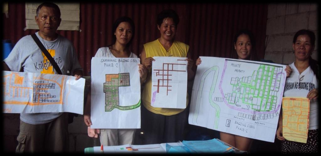
17 Mapping Core Team with Mayor Community Network formed as a result of Mapping

18 Part IV: Ways Forward Strengthening of community network of leaders (technical working groups) in the city through continuous capacity building in mapping related activities and savings implementation Consolidation of District 1 and 2 mapping information via the learning hub to come up with a citywide profile of informal settlement communities for Muntinlupa and present this to the city local housing board for incorporation to the city shelter plan and for project development Continuous training of the mapping team in the use of tools or strategies to help improve analysis of data generated (e.g to lessen data discrepancies or inconsistencies)


19 Part IV: Conclusion The mapping activities in Muntinlupa City have demonstrated that without accurate and comprehensive community information, neither communities nor governments will be able to overcome the challenges they face and work towards the eradication of poverty in the country. The results of community-led mapping and settlements profiling enabled the initiation of community formation of technical working groups among mapped ISF communities which capacitated them in: asserting their right towards land security; created a venue for close collaboration among various stakeholders in settlements development which further formed connections locally and internationally; paved the way for the LGU to recognize the potentials of CDA in addressing issues on land and poverty the introduction and use of collaborative land information tool such as STDM is seen to boost participation from communities, as they readily see outcomes in the form of maps that relate their individual information to their location or the land they live in.
20 Thank you!
Concept note. High-Level Seminar: Accelerating Sustainable Energy for All in Landlocked Developing Countries through Innovative Partnerships
 Concept note High-Level Seminar: Accelerating Sustainable Energy for All in Landlocked Developing Countries through Innovative Partnerships Date: 24 and 25 October 2016 Venue: Conference Room C3, Vienna
RETA 6422: Mainstreaming Environment for Poverty Reduction Category 2 Subproject
 RETA 6422: Mainstreaming Environment for Poverty Reduction Category 2 Subproject A. Basic Data 1. Subproject Title: Poverty-Environment Mapping to Support Decision Making 2. Country Director: Adrian Ruthenberg
Measuring Disaster Risk for Urban areas in Asia-Pacific
 Measuring Disaster Risk for Urban areas in Asia-Pacific Acknowledgement: Trevor Clifford, Intl Consultant 1 SDG 11 Make cities and human settlements inclusive, safe, resilient and sustainable 11.1: By
Urban Climate Resilience
 Urban Climate Resilience in Southeast Asia Partnership Project Introduction Planning for climate change is a daunting challenge for governments in the Mekong Region. Limited capacity at the municipal level,
Bhutan: FCPF Readiness Grant FCPFR - FOREST CARBON PARTNERSHIP FACILITY
 Assignment: TF019030 Bhutan: FCPF Readiness Grant FCPFR - FOREST CARBON PARTNERSHIP FACILITY Task Team Leader: 00000290015 Approving Manager: 00000082671 - Dora Nsuwa Cudjoe - Kseniya Lvovsky Summary Information
DRRM in the Philippines: DRRM Projects, Geoportals and Socio-Economic Integration
 Regional workshop on Geo-referenced information system for improving disaster risk preparedness and management in Asia and the Pacific 26-27 June 2014, UNCC, Bangkok, Thailand DRRM in the Philippines:
Implementing the Sustainable Development Goals: The Role of Geospatial Technology and Innovation
 Fifth High Level Forum on UN Global Geospatial Information Management Implementing the Sustainable Development Goals: The Role of Geospatial Technology and Innovation 28-30 November 2017 Sheraton Maria
ACTION PLAN FOR WORLD HERITAGE IN LATIN AMERICA AND THE CARIBBEAN ( )
") Annex ACTION PLAN FOR WORLD HERITAGE IN LATIN AMERICA AND THE CARIBBEAN (2014-2024) The current Regional Action Plan for Latin America and the Caribbean for 2014-2024 has been elaborated by the State Parties
Annex ACTION PLAN FOR WORLD HERITAGE IN LATIN AMERICA AND THE CARIBBEAN (2014-2024) The current Regional Action Plan for Latin America and the Caribbean for 2014-2024 has been elaborated by the State Parties
NEPAL: FCPF READINESS GRANT FCPFR - FOREST CARBON PARTNERSHIP FACILITY
 Assignment: TF094724 NEPAL: FCPF READINESS GRANT FCPFR - FOREST CARBON PARTNERSHIP FACILITY Task Team Leader: 00000240969 Approving Manager: 00000082671 - Abdelaziz Lagnaoui - Kseniya Lvovsky Summary Information
Towards Reliable Spatial Database of Informal Areas in Greater Cairo Region
 KEYWORDS informal areas, unreliable spatial data, spatial data collecting, capacity building SUMMARY The uncontrolled and rapid increase of Egypt s cities is a major problem of the country. More than the
Governance and Disaster Recovery: Lessons from the Field
 Governance and Disaster Recovery: Lessons from the Field Build it Better Leadership Forum Charlotte, North Carolina Gavin Smith, Ph.D., AICP Associate Research Professor University of North Carolina at
KUNMING FORUM ON UNITED NATIONS GLOBAL GEOSPATIAL INFORMATION MANAGEMENT CITIES OF THE FUTURE: SMART, RESILIENT
 KUNMING FORUM ON UNITED NATIONS GLOBAL GEOSPATIAL INFORMATION MANAGEMENT CITIES OF THE FUTURE: SMART, RESILIENT and SUSTAINABLE Yunnan Zhenzhuang Guest House, Kunming, China 10 12 May 2017 BACKGROUND CONCEPT
Weather Climate Science to Service Partnership South Africa
 PROJECTS UNDERWAY Title of the Weather Climate Science to Service Partnership South Africa Together, building on an existing strong partnership, South African Weather Service and the Met Office will build
Geospatial Technologies for Resources Planning & Management
 Geospatial Technologies for Resources Planning & Management Lal Samarakoon, PhD Director, Geoinformatics Center Asian Institute of Technology, Thailand Content Geoinformatics for SDG Information Integration
Preparing the GEOGRAPHY for the 2011 Population Census of South Africa
 Preparing the GEOGRAPHY for the 2011 Population Census of South Africa Sharthi Laldaparsad Statistics South Africa; E-mail: sharthil@statssa.gov.za Abstract: Statistics South Africa (Stats SA) s Geography
PROGRESS REPORT ON APPROACH PAPER THE IMPLEMENTATION OF THE GEF KNOWLEDGE MANAGEMENT. GEF/C.49/Inf.04 September 23, 2015
 49 th GEF Council Meeting October 20 22, 2015 Washington, D.C. GEF/C.49/Inf.04 September 23, 2015 PROGRESS REPORT ON THE IMPLEMENTATION OF THE GEF KNOWLEDGE MANAGEMENT APPROACH PAPER TABLE OF CONTENTS
CONFERENCE STATEMENT
 CONFERENCE STATEMENT We, the elected representatives from Canada, Denmark/Greenland, Finland, Iceland, Norway, Russia, Sweden and the United States of America; In collaboration with the indigenous peoples
Urbanization and Sustainable Development of Cities: A Ready Engine to Promote Economic Growth and Cooperation
 Urbanization and Sustainable Development of Cities: A Ready Engine to Promote Economic Growth and Cooperation Wan Portia Hamzah Institute of Strategic and International Studies (ISIS) Malaysia 10 September
2018/1 The integration of statistical and geospatial information. The Regional Committee of UN-GGIM: Americas:
 The following are the conclusions and recommendations of the Regional Committee of the United Nations on Global Geospatial Information Management for the Americas, during its Fifth Session, Thursday 8
CHAPTER 4 HIGH LEVEL SPATIAL DEVELOPMENT FRAMEWORK (SDF) Page 95
 Page 95") CHAPTER 4 HIGH LEVEL SPATIAL DEVELOPMENT FRAMEWORK (SDF) Page 95 CHAPTER 4 HIGH LEVEL SPATIAL DEVELOPMENT FRAMEWORK 4.1 INTRODUCTION This chapter provides a high level overview of George Municipality s
CHAPTER 4 HIGH LEVEL SPATIAL DEVELOPMENT FRAMEWORK (SDF) Page 95 CHAPTER 4 HIGH LEVEL SPATIAL DEVELOPMENT FRAMEWORK 4.1 INTRODUCTION This chapter provides a high level overview of George Municipality s
GOVERNMENT MAPPING WORKSHOP RECOVER Edmonton s Urban Wellness Plan Mapping Workshop December 4, 2017
 GOVERNMENT MAPPING WORKSHOP 12.4.17 RECOVER Edmonton s Urban Wellness Plan Mapping Workshop December 4, 2017 In July of 2017, City Council directed administration to develop RECOVER, Edmonton s Urban Wellness
FIG Asia Pacific Capacity Development Network
 FIG Asia Pacific Capacity Development Network Report to the 41th General Assembly FIG Congress 2018, Istanbul - Turkey Rob Sarib Chair FIG Asia Pacific Capacity Development Network (AP CDN) Story of the
Briefing. H.E. Mr. Gyan Chandra Acharya
 Briefing by H.E. Mr. Gyan Chandra Acharya Under-Secretary-General and High Representative for the Least Developed Countries, Landlocked Developing Countries and Small Island Developing States Briefing
Together towards a Sustainable Urban Agenda
 Together towards a Sustainable Urban Agenda The City We (Youth) Want Preliminary findings from youth consultations Areas Issue Papers Policy Units 1.Social Cohesion and Equity - Livable Cities 2.Urban
Proposed Scope of Work Village of Farmingdale Downtown Farmingdale BOA Step 2 BOA Nomination Study / Draft Generic Environmental Impact Statement
 Proposed Scope of Work Village of Farmingdale Downtown Farmingdale BOA Step 2 BOA Nomination Study / Draft Generic Environmental Impact Statement The scope of work that follows incorporates and covers
CfC REFORM STORY NO. 9 PAGE 04
 CfC REFORM STORY NO. 9 PAGE 04 Footnote here CfC REFORM STORY NO. 9 PAGE 02 CfC REFORM STORY NO. 9 PAGE 03 Coalitions for Change is a centerpiece program of the partnership between the Australian Embassy
Background Document: Report of the Regional Committee of United Nations Global Geospatial Information Management for Asia and the Pacific
 Background Document: Report of the Regional Committee of United Nations Global Geospatial Information Management for Asia and the Pacific 1. Summary 1. This report highlights the activities carried out
Creating a Staff Development Plan with Esri
 Creating a Staff Development Plan with Esri Michael Green David Schneider Guest Presenter: Shane Feirer, University of California Esri UC 2014 Technical Workshop Agenda What is a Staff Development Plan?
Asia Pacific Ministerial Conference on Housing and Urban Development (APMCHUD) Meeting of the Working Group on Urban and Rural Planning and Management
 Meeting of the Working Group on Urban and Rural Planning and Management") Asia Pacific Ministerial Conference on Housing and Urban Development (APMCHUD) Meeting of the Working Group on Urban and Rural Planning and Management August 16 17, 2012 New Delhi Recommendations of the
Asia Pacific Ministerial Conference on Housing and Urban Development (APMCHUD) Meeting of the Working Group on Urban and Rural Planning and Management August 16 17, 2012 New Delhi Recommendations of the
WORLD COUNCIL ON CITY DATA
 WORLD COUNCIL ON CITY DATA WCCD ISO 37120 STANDARDIZED CITY DATA TO MEET UN SDG TARGETS UN WORLD DATA FORUM Presented by: James Patava www.dataforcities.org @wccitydata PUBLICATION OF THE FIRST ISO STANDARD
DAGUPAN CITY EXPERIENCES, GOOD PRACTICES, CHALLENGES AND LESSONS LEARNED ON DISASTER RISK MANAGEMENT
 DAGUPAN CITY EXPERIENCES, GOOD PRACTICES, CHALLENGES AND LESSONS LEARNED ON DISASTER RISK MANAGEMENT Reducing Vulnerability to Climate Change Impacts and Related Natural Disasters in East Asia 12 and 13
Applying Hazard Maps to Urban Planning
 Applying Hazard Maps to Urban Planning September 10th, 2014 SAKAI Yuko Disaster Management Expert JICA Study Team for the Metro Cebu Roadmap Study on the Sustainable Urban Development 1 Contents 1. Outline
USER PARTICIPATION IN HOUSING REGENERATION PROJECTS
 USER PARTICIPATION IN HOUSING REGENERATION PROJECTS Dr. Hatice Sadıkoğlu Bahçeşehir University, Faculty of Architecture and Design Prof. Dr. Ahsen Özsoy Istanbul Technical University, Faculty of Architecture
ANGOLA: PARTICIPATORY MAPPING OF URBAN POVERTY. By Allan Cain, Development Workshop
 ANGOLA: PARTICIPATORY MAPPING OF URBAN POVERTY By Allan Cain, Development Workshop Angola: Participatory Mapping of Urban Poverty BY ALLAN CAIN, DEVELOPMENT WORKSHOP This paper explains a method for measuring
CONFERENCE STATEMENT
 Final draft CONFERENCE STATEMENT We, the elected representatives of Canada, Denmark/Greenland, the European Parliament, Finland, Iceland, Norway, Russia, Sweden and the United States of America; In collaboration
Indonesia - FCPF Readiness Preparation Grant FCPFR - Forest Carbon Partnership Facility
 Assignment: TF099721 Indonesia - FCPF Readiness Preparation Grant FCPFR - Forest Carbon Partnership Facility Task Team Leader: 00000176411 Approving Manager: 00000066054 - Dinesh Aryal - Iain G. Shuker
Economic and Social Council
 United Nations Economic and Social Council 28 December 2000 Original: English E/CN.3/2001/2 Statistical Commission Thirty-second session 6-9 March 2001 Item 3 (a) of the provisional agenda * Demographic
Social Vulnerability in Metro Manila: Implications for Preparedness and Response "
 Social Vulnerability in Metro Manila: Implications for Preparedness and Response " Earthquake Resilience Conference: Collaboration and Coordination in Preparedness and Response" 20-21 May 2015" Antonia
Realizing benefits of Spatial Data Infrastructure A user s perspective from Environment Agency - Abu Dhabi
 Realizing benefits of Spatial Data Infrastructure A user s perspective from Environment Agency - Abu Dhabi Anil Kumar Director, Environment Information Management 26 April 2012 Geospatial World Forum,
UN-GGIM: Strengthening Geospatial Capability
 Fifth Plenary Meeting of UN-GGIM: Europe Brussels, 6-7 June 2018 UN-GGIM: Strengthening Geospatial Capability Walking the talk to leave no one behind Greg Scott, UN-GGIM Secretariat Environmental Statistics
Aboriginal communities strengthen governance with location-based tools in the 21st century
 Aboriginal communities strengthen governance with location-based tools in the 21st century Today, Aboriginal communities are taking advantage of the geomatics technologies that underpin popular online
THE ROLE OF GEOSPATIAL AT THE WORLD BANK
 THE ROLE OF GEOSPATIAL AT THE WORLD BANK INSPIRE Conference Barcelona, Spain September 26, 2016 Kathrine Kelm Senior Land Administration Specialist Global Land and Geospatial Unit The World Bank Group
Economic and Social Council
 United Nations Economic and Social Council Distr.: General 18 July 2016 Original: English Committee of Experts on Global Geospatial Information Management Sixth session New York, 3-5 August 2016 Item 2
PAN AMERICAN INSTITUTE OF GEOGRAPHY AND HISTORY Specialized Organization of the OAS
 PAN AMERICAN INSTITUTE OF GEOGRAPHY AND HISTORY Specialized Organization of the OAS 10 th UNRCC Americas United Nations, New York, 20 August 2013 PAIGH, SIRGAS, PC-IDEA and GeoSUR 2013-2015 Joint Action
A Framework for the Study of Urban Health. Abdullah Baqui, DrPH, MPH, MBBS Johns Hopkins University
 This work is licensed under a Creative Commons Attribution-NonCommercial-ShareAlike License. Your use of this material constitutes acceptance of that license and the conditions of use of materials on this
Al Ain Cultural Heritage Management Strategy 1/102
 AL AIN CULTURAL HERITAGE MANAGEMENT STRATEGY EXECUTIVE SUMMARY The cultural heritage of Al Ain is rich and varied; it consists of tangible and intangible resources and incorporates archaeological sites,
What is Spatial Planning?
 Spatial Planning in the context of the Responsible Governance of Tenure What is Spatial Planning? Text-only version This course is funded by the European Union through the EU-FAO Improved Global Governance
The World Bank Caribbean Regional Communications Infrastructure Program (P114963)
") Public Disclosure Authorized LATIN AMERICA AND CARIBBEAN Caribbean Transport & ICT Global Practice IBRD/IDA Adaptable Program Loan FY 2012 Seq No: 10 ARCHIVED on 18-Oct-2017 ISR29473 Implementing Agencies:
Public Disclosure Authorized LATIN AMERICA AND CARIBBEAN Caribbean Transport & ICT Global Practice IBRD/IDA Adaptable Program Loan FY 2012 Seq No: 10 ARCHIVED on 18-Oct-2017 ISR29473 Implementing Agencies:
RURAL-URBAN PARTNERSHIPS: AN INTEGRATED APPROACH TO ECONOMIC DEVELOPMENT
 RURAL-URBAN PARTNERSHIPS: AN INTEGRATED APPROACH TO ECONOMIC DEVELOPMENT William Tompson Head of the Urban Development Programme OECD Public Governance and Territorial Development Directorate JAHRESTAGUNG
Jordan's Strategic Research Agenda in cultural heritage
 Jordan's Strategic Research Agenda in cultural heritage Analysis of main results Alessandra Gandini Amman, Jordan 3 rd November 2013 Main objectives The work performed had the main objective of giving
Local EPM Implementation Process in 5 stages
 Local PM Implementation Process in 5 stages 3. Working groups 1. City nvironmental Profile/ Outlook 5. Consolidation & Institutionalisation 4. Strategy & Action plans 2. City Consultation Urban nvironmental
Mapping Secondary Cities for Resiliency and Emergency Preparedness
 Mapping Secondary Cities for Resiliency and Emergency Preparedness Secondary Cities Geospatial Training Workshop Pilot Project: Cusco, Peru June 29 July 3 2015 WHO ARE WE? Office of the Geographer (GGI)
COSTA RICA Limon City-Port Project
 photos by Stefania Abakerli COSTA RICA Limon City-Port Project 2008 2013 Cecilia Corvalan William Reuben Stefania Abakerli Background Request from GoCR following Caldera-Port Concession Reform Since the
MISSOURI LiDAR Stakeholders Meeting
 MISSOURI LiDAR Stakeholders Meeting East-West Gateway June 18, 2010 Tim Haithcoat Missouri GIO Enhanced Elevation Data What s different about it? Business requirements are changing.fast New data collection
ESCAP Promotes Geo-referenced Information System for Disaster Risk Management in Asia and the Pacific
 Third High Level Forum on UNGGIM 22-24 October 2014 Beijing, China ESCAP Promotes Geo-referenced Information System for Disaster Risk Management in Asia and the Pacific Keran Wang Space Applications Section,
The World Bank Health System Performance Reinforcement Project (P156679)
") Public Disclosure Authorized AFRICA Cameroon Health, Nutrition & Population Global Practice IBRD/IDA Investment Project Financing FY 2016 Seq No: 3 ARCHIVED on 14-Apr-2017 ISR27518 Implementing Agencies:
Public Disclosure Authorized AFRICA Cameroon Health, Nutrition & Population Global Practice IBRD/IDA Investment Project Financing FY 2016 Seq No: 3 ARCHIVED on 14-Apr-2017 ISR27518 Implementing Agencies:
NSDI as a tool for Secure land tenure
 NSDI as a tool for Secure land tenure General Overview To look at the progress in SDI development and its application in policy formulation and impact on land tenure. INTEGRATION OF INFORMATION POLICIES
THE SEVILLE STRATEGY ON BIOSPHERE RESERVES
 THE SEVILLE STRATEGY ON BIOSPHERE RESERVES 1 VISION FOR BIOSPHERE RESERVES IN THE 21 ST CENTURY The international Seville Conference on Biosphere Reserves, organised by UNESCO, adopted a two-pronged approach,
Capacity building and the global human settlement data. Richard Sliuzas, University of Twente Vincent Seaman, Bill & Melinda Gates Foundation
 Capacity building and the global human settlement data Richard Sliuzas, University of Twente Vincent Seaman, Bill & Melinda Gates Foundation Content Capacity development Capabilities approach Some issues
Key Dates. Project Development Objectives. Components. Overall Ratings
 Public Disclosure Authorized EAST ASIA AND PACIFIC Philippines Water Global Practice IBRD/IDA Investment Project Financing FY 2018 Seq No: 1 ARCHIVED on 21-Dec-2017 ISR30930 Implementing Agencies: Department
Public Disclosure Copy
 Public Disclosure Authorized AFRICA Zambia Environment & Natural Resources Global Practice Recipient Executed Activities Investment Project Financing FY 2013 Seq No: 9 ARCHIVED on 27-Dec-2017 ISR30903
50 th GEF Council Meeting June 07 09, 2016 Washington, D.C. GEF/C.50/Inf.07 May 11, 2016 PROGRESS REPORT ON THE GENDER EQUALITY ACTION PLAN
 50 th GEF Council Meeting June 07 09, 206 Washington, D.C. GEF/C.50/Inf.07 May, 206 PROGRESS REPORT ON THE GENDER EQUALITY ACTION PLAN TABLE OF CONTENTS Background on the Gender Equality Action Plan (GEAP)...
The World Bank Decentralized Community Driven Services Project (P117764)
") Public Disclosure Authorized AFRICA Benin Social Protection Global Practice IBRD/IDA Adaptable Program Loan FY 2012 Seq No: 6 ARCHIVED on 12-Jun-2015 ISR19748 Implementing Agencies: Public Disclosure Authorized
Public Disclosure Authorized AFRICA Benin Social Protection Global Practice IBRD/IDA Adaptable Program Loan FY 2012 Seq No: 6 ARCHIVED on 12-Jun-2015 ISR19748 Implementing Agencies: Public Disclosure Authorized
World Bank Group GEF Program
 World Bank Group GEF Program Global Environment Facility: -Transport World Bank GEF Coordination Team Content How does GEF work? World Bank s role in the GEF partnership The GEF transport activities What
ITHUBA COMMUNITY CENTRE BLACKBURN VILLAGE SOCIAL SUSTAINABLE INTERGRATED PROGRAM
 Response to How the City s approached on attaining Urban Opportunities, Social Capital through meaningful collaborations & partnerships that places people at the heart. ITHUBA COMMUNITY CENTRE BLACKBURN
Land Use in the context of sustainable, smart and inclusive growth
 Land Use in the context of sustainable, smart and inclusive growth François Salgé Ministry of sustainable development France facilitator EUROGI vice president AFIGéO board member 1 Introduction e-content+
ENVIRONMENTAL CONSIDERATIONS IN CLUP
 ENVIRONMENTAL CONSIDERATIONS IN CLUP Ricardo M. Sandalo Assistant Professor DCERP, College of Human Ecology University of the Philippines Los Baños April 9-10, 2016 CHE Multi Purpose Hall 1 Twin Objectives
The World Bank Mali Reconstruction and Economic Recovery (P144442)
") Public Disclosure Authorized AFRICA Mali Social, Urban, Rural and Resilience Global Practice Global Practice IBRD/IDA Emergency Recovery Loan FY 2014 Seq No: 7 ARCHIVED on 30-Jun-2017 ISR28723 Implementing
Public Disclosure Authorized AFRICA Mali Social, Urban, Rural and Resilience Global Practice Global Practice IBRD/IDA Emergency Recovery Loan FY 2014 Seq No: 7 ARCHIVED on 30-Jun-2017 ISR28723 Implementing
Disaster Management & Recovery Framework: The Surveyors Response
 Disaster Management & Recovery Framework: The Surveyors Response Greg Scott Inter-Regional Advisor Global Geospatial Information Management United Nations Statistics Division Department of Economic and
Regional stakeholders strategy of Donegal County Council
 Regional stakeholders strategy of Donegal County Council Table of contents The template comprised five steps in the creation of this communication strategy: 1 Starting point. Communication objectives...
The World Bank Caribbean Regional Communications Infrastructure Program (P114963)
") Public Disclosure Authorized LATIN AMERICA AND CARIBBEAN Caribbean Transport & ICT Global Practice IBRD/IDA Adaptable Program Loan FY 2012 Seq No: 9 ARCHIVED on 25-Jan-2017 ISR26209 Implementing Agencies:
Public Disclosure Authorized LATIN AMERICA AND CARIBBEAN Caribbean Transport & ICT Global Practice IBRD/IDA Adaptable Program Loan FY 2012 Seq No: 9 ARCHIVED on 25-Jan-2017 ISR26209 Implementing Agencies:
The World Bank Sri Lanka Agriculture Sector Modernization Project (P156019)
") Public Disclosure Authorized SOUTH ASIA Sri Lanka Agriculture Global Practice IBRD/IDA Investment Project Financing FY 2016 Seq No: 4 ARCHIVED on 09-Jan-2018 ISR31203 Implementing Agencies: Ministry of
Public Disclosure Authorized SOUTH ASIA Sri Lanka Agriculture Global Practice IBRD/IDA Investment Project Financing FY 2016 Seq No: 4 ARCHIVED on 09-Jan-2018 ISR31203 Implementing Agencies: Ministry of
PUBLIC HEALTH ASSOCIATION OF AUSTRALIA Strategic Plan
 PUBLIC HEALTH ASSOCIATION OF AUSTRALIA Strategic Plan March 2017 20 Napier Close Deakin ACT Australia 2600 PO Box 319 Curtin ACT Australia 2605 Table of Contents Introduction... 2 Vision for a healthy
COUNCIL OF THE EUROPEAN UNION. Brussels, 2 May /14 CULT 68
 COUNCIL OF THE EUROPEAN UNION Brussels, 2 May 2014 9129/14 CULT 68 NOTE from: General Secretariat of the Council to: Permanent Representatives Committee (Part 1) / Council No. prev. doc.: 8892/14 CULT
ACTION PLAN FOR WORLD HERITAGE IN LATIN AMERICA AND THE CARIBBEAN
 Final version-to send to the ACTION PLAN FOR WORLD HERITAGE IN LATIN AMERICA AND THE CARIBBEAN 2014-2024 The current Regional Action Plan for Latin America and the Caribbean has been elaborated by the
1) United Nations Committee of Experts on Global Geospatial Information Management (UN-GGIM)
 United Nations Committee of Experts on Global Geospatial Information Management (UN-GGIM)") International Workshop on Legal and Policy Frameworks for Geospatial Information Management Licensing of Geospatial Information 7 9 November 2017 Tianjin Zhengxie Club Hotel Tianjin, China Outline of presentation
International Workshop on Legal and Policy Frameworks for Geospatial Information Management Licensing of Geospatial Information 7 9 November 2017 Tianjin Zhengxie Club Hotel Tianjin, China Outline of presentation
Sustainable Development Goal 11 and the New Urban Agenda: can planning deliver? Vanessa Watson University of Cape Town 2016
 Sustainable Development Goal 11 and the New Urban Agenda: can planning deliver? Vanessa Watson University of Cape Town 2016 .to reinvigorate the global political commitment to the sustainable development
Community Engagement in Cultural Routes SiTI Higher Institute on Territorial Systems for Innovation Sara Levi Sacerdotti
 Transnational Workshop Wroclaw, 7th-8th December 2016 Community Engagement in Cultural Routes SiTI Higher Institute on Territorial Systems for Innovation Sara Levi Sacerdotti levi@siti.polito.it TAKING
NATIONAL MAPPING EFFORTS: THE PHILIPPINES
 NATIONAL MAPPING EFFORTS: THE PHILIPPINES Dr. RIJALDIA N. SANTOS DENR National Mapping and Resource Information Authority (NAMRIA) May 30, 2018 Land Cover/Land Use Changes (LC/LUC) and Its Impacts on Environment
Economic and Social Council
 United Nations Economic and Social Council Distr.: General 2 July 2012 E/C.20/2012/10/Add.1 Original: English Committee of Experts on Global Geospatial Information Management Second session New York, 13-15
Spatially Enabled Society
 International Seminar on Land Administration Trends and Issues in Asia and the Pacific Region Spatially Enabled Society Abbas Rajabifard Vice Chair PCGIAP-WG3 Vice-President (President Elect), GSDI Association
Hɛn Mpoano Policy Brief Series. A nested coastal and marine governance system
 Hɛn Mpoano Policy Brief Series A nested coastal and marine governance system Policy Brief 1, December 2012 Coastal Resources Center, University of Rhode Island This publication is available electronically
Generic Success Criteria
 Generic Success Criteria Significance I can identify a short term and long term impact that a development/event/issue has/had locally/globally. I can discuss (verbally, graphically, etc.) how a development/event/issue
Transforming Cities and Saving Lives: Making the Case for Urban Reproductive Health
 URBAN REPRODUCTIVE HEALTH PRE-CONFERENCE MEETING Gates Institute and IUSSP - Kigale 11-12, November 2018 Transforming Cities and Saving Lives: Making the Case for Urban Reproductive Health SITUATING THE
Pacific Geospatial and Surveying Council (PGSC) Geospatial and GNSS CORS Infrastructure Forum. Kuala Lumpur October
 Geospatial and GNSS CORS Infrastructure Forum. Kuala Lumpur October") Pacific Geospatial and Surveying Council (PGSC) Geospatial and GNSS CORS Infrastructure Forum. Kuala Lumpur 16-17 October Beginning and Progress Members PGSC Charter PGSC Strategy 2017-2027 Meetings Geodetic
Pacific Geospatial and Surveying Council (PGSC) Geospatial and GNSS CORS Infrastructure Forum. Kuala Lumpur 16-17 October Beginning and Progress Members PGSC Charter PGSC Strategy 2017-2027 Meetings Geodetic
ArcGIS Urban: An Introduction. Lisa Staehli ArcGIS Urban Team Product Development Brooks Patrick ArcGIS Urban Team Business Development
 ArcGIS Urban: An Introduction Lisa Staehli ArcGIS Urban Team Product Development Brooks Patrick ArcGIS Urban Team Business Development Our Cities Are Facing Massive Challenges Our Cities Are Facing Massive
The World Bank Indonesia National Slum Upgrading Project (P154782)
") Public Disclosure Authorized EAST ASIA AND PACIFIC Indonesia Social, Urban, Rural and Resilience Global Practice Global Practice IBRD/IDA Investment Project Financing FY 2017 Seq No: 4 ARCHIVED on 04-Apr-2018
Public Disclosure Authorized EAST ASIA AND PACIFIC Indonesia Social, Urban, Rural and Resilience Global Practice Global Practice IBRD/IDA Investment Project Financing FY 2017 Seq No: 4 ARCHIVED on 04-Apr-2018
TERRITORIAL IMPACT ASSESSMENT: AN APPROACH TO IMPROVE THE VERTICAL AND HORIZONTAL INTEGRATION OF EU POLICIES
 TERRITORIAL IMPACT ASSESSMENT: AN APPROACH TO IMPROVE THE VERTICAL AND HORIZONTAL INTEGRATION OF EU POLICIES Naja Marot & Mojca Golobič Biotehnical Faculty, University of Ljubljana, Slovenia RSA Workshop
The World Bank Community Development Program Support Project-Phase III (P144637)
") Public Disclosure Authorized AFRICA Cameroon Social, Urban, Rural and Resilience Global Practice Global Practice IBRD/IDA Investment Project Financing FY 2016 Seq No: 4 ARCHIVED on 20-Jun-2017 ISR27942
Public Disclosure Authorized AFRICA Cameroon Social, Urban, Rural and Resilience Global Practice Global Practice IBRD/IDA Investment Project Financing FY 2016 Seq No: 4 ARCHIVED on 20-Jun-2017 ISR27942
Presentation by Thangavel Palanivel Senior Strategic Advisor and Chief Economist UNDP Regional Bureau for Asia-Pacific
 Presentation by Thangavel Palanivel Senior Strategic Advisor and Chief Economist UNDP Regional Bureau for Asia-Pacific The High-Level Euro-Asia Regional Meeting on Improving Cooperation on Transit, Trade
Sudan REDD+ Readiness Preparation Support FCPFR - FOREST CARBON PARTNERSHIP FACILITY
 Assignment: TF019148 Sudan REDD+ Readiness Preparation Support FCPFR - FOREST CARBON PARTNERSHIP FACILITY Task Team Leader: 00000383531 Approving Manager: 00000086248 - Asferachew Abate Abebe - Magdolna
Crowdsourcing approach for large scale mapping of built-up land
 Crowdsourcing approach for large scale mapping of built-up land Kavinda Gunasekara Kavinda@ait.asia Geoinformatics Center Asian Institute of Technology, Thailand. Regional expert workshop on land accounting
The World Bank Indonesia National Slum Upgrading Project (P154782)
") Public Disclosure Authorized EAST ASIA AND PACIFIC Indonesia Social, Urban, Rural and Resilience Global Practice Global Practice IBRD/IDA Investment Project Financing FY 2017 Seq No: 2 ARCHIVED on 19-May-2017
Public Disclosure Authorized EAST ASIA AND PACIFIC Indonesia Social, Urban, Rural and Resilience Global Practice Global Practice IBRD/IDA Investment Project Financing FY 2017 Seq No: 2 ARCHIVED on 19-May-2017
Governance and Urban Nexus: Closing the gaps
 Governance and Urban Nexus: Closing the gaps Donovan Storey Chief, Sustainable Urban Development, Environment & Development Division National Dialogue on Urban Nexus in Thailand Bangkok, UNCC, 19 March
INDONESIA S S UPDATE: GEOSPATIAL INFORMATION FOR SUSTAINABLE DEVELOPMENT RELATED TO INA SDI Dr. Asep Karsidi, M.Sc
 INDONESIA S S UPDATE: GEOSPATIAL INFORMATION FOR SUSTAINABLE DEVELOPMENT RELATED TO INA SDI Dr. Asep Karsidi, M.Sc GEOSPATIAL INFORMATION AGENCY 08 August, 2012 OUTLINE 1. Transformation Bakosurtanal into
The World Bank JM Youth Employment in Digital and Animation Industries (P148013)
") Public Disclosure Authorized LATIN AMERICA AND CARIBBEAN Jamaica Social, Urban, Rural and Resilience Global Practice Global Practice IBRD/IDA Investment Project Financing FY 2015 Seq No: 6 ARCHIVED on
Public Disclosure Authorized LATIN AMERICA AND CARIBBEAN Jamaica Social, Urban, Rural and Resilience Global Practice Global Practice IBRD/IDA Investment Project Financing FY 2015 Seq No: 6 ARCHIVED on
International Guidelines on Access to Basic Services for All
 International Guidelines on Access to Basic Services for All Presentation and initials lessons from implementation Accessibility to services in regions and cities : measures and policies, OECD 18 June
KENYA NATIONAL BUREAU OF STATISTICS Workshop on
 KENYA NATIONAL BUREAU OF STATISTICS Workshop on Capacity Building in Environment Statistics: the Framework for the Development of Environment Statistics (FDES 2013) Coordination with Sector Ministries
Welcome. C o n n e c t i n g
 Welcome C o n n e c t i n g YOU D i s c i p l i n e s Why is This Meeting......So Important Now? OUR WORLD Is Increasingly Challenged The Evidence Is Clear We Need Better Understanding and More Collaboration
New Partners for Smart Growth: Building Safe, Healthy, and Livable Communities Mayor Jay Williams, Youngstown OH
 New Partners for Smart Growth: Building Safe, Healthy, and Livable Communities Mayor Jay Williams, Youngstown OH The City of Youngstown Youngstown State University Urban Strategies Inc. Youngstown needed