Boundary layer Decoupling Affects on Tornadoes. Chris Karstens Meteorology 507 May 6, 2008
|
|
|
- Arron Gibson
- 5 years ago
- Views:
Transcription

1 Boundary layer Decoupling Affects on Tornadoes Chris Karstens Meteorology 507 May 6, 2008
2 Outline Background Motivation Methodology Results Conclusions References Questions
3 Blackadar (1957). Background Solar heating causes the PBL to become well mixed. Vertical transport of momentum, sub geostrophic winds. About 1 hour prior to sunset, net upward radiation flux reduces to zero. Nocturnal stable layer forms, decoupling the residual PBL from the surface.
4 Background The residual PBL is allowed to acceleration toward geostrophic balance through an inertial oscillation. Forms the low level jet. The effect of friction in the nocturnal stable layer is enhanced. Increases the ageostrophic component of the wind.
5 Background Storms developing in environments with large lowlevel shear values have a higher probability for producing tornadoes (Rasmussen and Blanchard, 1998). (Rasmussen and Blanchard, 1998)
")
6 Background Large spatial and temporal fluctuations in SRH can exist in the near storm environment (Markowski et al., 1998). Might offer an explanation as to why some storms produce tornadoes and why other do not. (Markowski and Richardson, 2007)
(Miller, 2006). Kink in the hodograph, giving it a sickle shape.")
7 Background Hodograph structures from proximity soundings near significant tornadoes show similarities (Thompson and Edwards, 2000)(Miller, 2006). Kink in the hodograph, giving it a sickle shape. (Miller, 2006)
8 Motivation Theonsetofthelowleveljetcouldrapidlyalteran environment toward becoming more favorable for producing tornadoes. Is there any evidence of this phenomena? Historical tornado reports. Observed and model soundings.
9 Methodology Analysis of the historical tornado records. Each report has the location, latitude and longitude, the date, and the time (CDT) recorded. Using the lat, lon, & the date, the sunset for each location could be determined. This was used to normalized the reports. 0 = sunset 12 to 0 = before sunset 0 to 12 = after sunset Distributions were then constructed. Represented in ArcGIS, by CWA s.
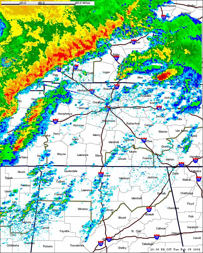
10 Methodology Analysis of proximity soundings. February 5, 2008 outbreak. Analysis of 18 UTC and 00 UTC radiosondes. How the environment changed leading up to the event. Analysis of RUC and NAM model soundings. The model s depiction of how the environment changed. Hodographs from each sounding type are used to analyzed the low level shear.
11 Results Distribution of all tornado reports, normalized to sunset

12 Results 1 to 3 hours prior to sunset
13 Results 1 hour prior to 1 hour after sunset
14 Conclusions No apparent increase in the number of reports coincides with the time when the boundary layer decouples from the surface. Opposite trend is apparent. Coincides with peak solar heating. A significant number of reports occur after peak solar heat. Further investigation.

15 Results Distribution of Feb. 5, 2008 tornado reports, normalized to sunset


16 Results Little Rock, AR 18 Z Jackson, MS 18 Z

17 Results Nashville, TN 00 Z


18 Results Nashville, TN 21 Z RUC 21 UTC 22 UTC 23UTC 00 UTC
19 Conclusions Analysis of proximity soundings show supporting evidence that boundary layer decoupling could be rapidly enhancing low level shear. Could offer a possible explanation as to why the environment suddenly changes in favor of producing tornadoes. Might be particularly true for storms residing in the warm sector, where the Blackadar (1957) analytical solution of the low level jet is valid. A sickle shape hodograph is noted, but could be completely coincidental.
20 References Blackadar, A. K., 1957: Boundary layer wind maxima and their significance for the growth of nocturnal inversions, Bull. Amer. Meteor. Soc., 38, Markowski, P. M., J. M. Straka, E. N. Rasmussen, and D. O. Blanchard, 1998: Variability of storm relative helicity during VORTEX. Mon. Wea. Rev., 126, Miller, D. J., 2006: Observations of low level thermodynamics and wind shear profiles on significant tornado days, Preprints, 23 rd Conference on Severe Local Storms, Saint Louis, MO. Rasmussen, E. N. and D. O. Blanchard, 1998: A baseline climatology of soundingderived supercell and tornado forecast parameters. Wea. Forecasting, 13, Thompson, R.L., and R. Edwards, 2000: An overview of environmental conditions and forecast implications of the 3 May 1999 tornado outbreak. Wea. Forecasting, 15,
21 Questions
Boundary-layer Decoupling Affects on Tornadoes
 Boundary-layer Decoupling Affects on Tornadoes Chris Karstens ABSTRACT The North American low-level jet is known to have substantial impacts on the climatology of central and eastern regions of the United
P1.13 GROUND BASED REMOTELY SENSED HIGH TEMPORAL RESOLUTION STABILITY INDICES ASSOCIATED WITH SOUTHERN GREAT PLAINS TORNADO OUTBREAKS
 P1.13 GROUND BASED REMOTELY SENSED HIGH TEMPORAL RESOLUTION STABILITY INDICES ASSOCIATED WITH SOUTHERN GREAT PLAINS TORNADO OUTBREAKS Timothy J. Wagner*, Wayne F. Feltz, Ralph Petersen, Steven A. Ackerman
WARM SECTOR TORNADOES WITHOUT DISCERNIBLE SURFACE BOUNDARIES AND WITH MINIMAL DEEP LAYER SHEA
 2.1 WARM SECTOR TORNADOES WITHOUT DISCERNIBLE SURFACE BOUNDARIES AND WITH MINIMAL DEEP LAYER SHEA * Joshua M. Boustead and Philip N. Schumacher National Weaer Service Sioux Falls, SD 1. INTRODUCTION On
P1.3 Tornadoes in a Deceptively Small CAPE Environment: The 4/20/04 Outbreak in Illinois and Indiana
 P1.3 Tornadoes in a Deceptively Small CAPE Environment: The 4/20/04 Outbreak in Illinois and Indiana Albert E. Pietrycha* Jonathan M. Davies #, Mark Ratzer*, and Paul Merzlock* *National Weather Service,
Jonathan M. Davies* Private Meteorologist, Wichita, Kansas
 4.3 RUC Soundings with Cool Season Tornadoes in Small CAPE Settings and the 6 November 2005 Evansville, Indiana Tornado Jonathan M. Davies* Private Meteorologist, Wichita, Kansas 1. Introduction Several
The Boundary Layer and Related Phenomena
 The Boundary Layer and Related Phenomena Jeremy A. Gibbs University of Oklahoma gibbz@ou.edu February 19, 2015 1 / 49 Overview Nocturnal Low-Level Jets Introduction Climatology of LLJs Meteorological Importance
A COMPREHENSIVE 5-YEAR SEVERE STORM ENVIRONMENT CLIMATOLOGY FOR THE CONTINENTAL UNITED STATES 3. RESULTS
 16A.4 A COMPREHENSIVE 5-YEAR SEVERE STORM ENVIRONMENT CLIMATOLOGY FOR THE CONTINENTAL UNITED STATES Russell S. Schneider 1 and Andrew R. Dean 1,2 1 DOC/NOAA/NWS/NCEP Storm Prediction Center 2 OU-NOAA Cooperative
Tornado Probabilities Derived from Rapid Update Cycle Forecast Soundings
 Tornado Probabilities Derived from Rapid Update Cycle Forecast Soundings Zachary M. Byko National Weather Center Research Experiences for Undergraduates, and The Pennsylvania State University, University
Determining Environmental Parameters Most Important for Significant Cool Season Tornadoes across the Gulf Coastal States
 Determining Environmental Parameters Most Important for Significant Cool Season Tornadoes across the Gulf Coastal States Kar retta Venable Jackson State University, Jackson, MS Mentors David Imy NOAA/NWS/NCEP/Storm
P8.10 AN EXAMINATION OF VARYING SUPERCELL ENVIRONMENTS OVER THE COMPLEX TERRAIN OF THE EASTERN TENNESSEE RIVER VALLEY
 P8.10 AN EXAMINATION OF VARYING SUPERCELL ENVIRONMENTS OVER THE COMPLEX TERRAIN OF THE EASTERN TENNESSEE RIVER VALLEY by David M. Gaffin* and David G. Hotz National Weather Service, Morristown TN 1. INTRODUCTION
Storm-Relative Flow and its Relationship to Low-Level Vorticity in Simulated Storms
 TH CONF. ON SEVERE LOCAL STORMS, 15. 1 Storm-Relative Flow and its Relationship to Low-Level Vorticity in Simulated Storms Cody Kirkpatrick University of Alabama in Huntsville Eugene W. McCaul, Jr. Universities
Hurricane and Tropical Cyclone Tornado Environments from RUC Proximity Soundings
 P8.1 Hurricane and Tropical Cyclone Tornado Environments from RUC Proximity Soundings Jonathan M. Davies* Private Meteorologist, Wichita, Kansas 1. Introduction Studies such as those by McCaul (1991, 1996)
Synoptic Environments Associated with Significant Tornadoes in the Contiguous United States
 Synoptic Environments Associated with Significant Tornadoes in the Contiguous United States JAYSON A. PRENTICE Department of Geological and Atmospheric Sciences, Iowa State University, Ames, IA Mentor:
Comparison of Estimated and Observed Storm Motions to Environmental Parameters
 Comparison of Estimated and Observed Storm Motions to Environmental Parameters Eric Beamesderfer 1, 2, 3, 4, Kiel Ortega 3, 4, Travis Smith 3, 4, and John Cintineo 4, 5 1 National Weather Center Research
P12.14 A SOUNDING-DERIVED CLIMATOLOGY OF SIGNIFICANT TORNADO EVENTS IN THE GREENVILLE-SPARTANBURG, SOUTH CAROLINA COUNTY WARNING AREA ( )
") P12.14 A SOUNDING-DERIVED CIMATOOGY OF SIGNIFICANT TORNADO EVENTS IN THE GREENVIE-SPARTANBURG, SOUTH CAROINA COUNTY WARNING AREA (1948-26) Justin D. ane* NOAA/National Weather Service Greer, South Carolina
P12.14 A SOUNDING-DERIVED CIMATOOGY OF SIGNIFICANT TORNADO EVENTS IN THE GREENVIE-SPARTANBURG, SOUTH CAROINA COUNTY WARNING AREA (1948-26) Justin D. ane* NOAA/National Weather Service Greer, South Carolina
Storm-Relative Flow and its Relationship to Low-Level Vorticity in Simulated Storms
 TH CONF. ON SEVERE LOCAL STORMS, 15. 1 Storm-Relative Flow and its Relationship to Low-Level Vorticity in Simulated Storms Cody Kirkpatrick University of Alabama in Huntsville Eugene W. McCaul, Jr. Universities
High-Resolution RUC CAPE Values and Their Relationship to Right Turning Supercells
 High-Resolution RUC CAPE Values and Their Relationship to Right Turning Supercells ANDREW H. MAIR Meteorology Program, Iowa State University, Ames, IA Mentor: Dr. William A. Gallus Jr. Department of Geological
David O. Blanchard* and Brian A. Klimowski National Weather Service, Flagstaff, Arizona
 P12.1 SUPERCE EVOUTION IN ENVIRONMENTS WITH UNUSUA HODOGRAPHS David O. Blanchard* and Brian A. Klimowski National Weather Service, Flagstaff, Arizona 1. INTRODUCTION The events that transpired across northern
Environmental Characteristics Associated with Nighttime Tornadoes
 National Weather Association, Electronic Journal of Operational Meteorology, 2009-EJ3 Environmental Characteristics Associated with Nighttime Tornadoes Jonathan M. Davies Private Meteorologist, Trimble/Kansas
11A.2 Forecasting Short Term Convective Mode And Evolution For Severe Storms Initiated Along Synoptic Boundaries
 11A.2 Forecasting Short Term Convective Mode And Evolution For Severe Storms Initiated Along Synoptic Boundaries Greg L. Dial and Jonathan P. Racy Storm Prediction Center, Norman, Oklahoma 1. Introduction
NOTES AND CORRESPONDENCE. Characteristics of Vertical Wind Profiles near Supercells Obtained from the Rapid Update Cycle
 1262 WEATHER AND FORECASTING NOTES AND CORRESPONDENCE Characteristics of Vertical Wind Profiles near Supercells Obtained from the Rapid Update Cycle PAUL MARKOWSKI, CHRISTINA HANNON, JEFF FRAME, ELISE
P4.479 A DETAILED ANALYSIS OF SPC HIGH RISK OUTLOOKS,
 P4.479 A DETAILED ANALYSIS OF SPC HIGH RISK OUTLOOKS, 2003-2009 Jason M. Davis*, Andrew R. Dean 2, and Jared L. Guyer 2 Valparaiso University, Valparaiso, IN 2 NOAA/NWS Storm Prediction Center, Norman,
DIFFICULTIES WITH CLASSIFYING AND ANALYZING THE LOW LEVEL JET IN A CONVECTION ALLOWING ENSEMBLE
 DIFFICULTIES WITH CLASSIFYING AND ANALYZING THE LOW LEVEL JET IN A CONVECTION ALLOWING ENSEMBLE Emily N. Tinney 1 and James Correia Jr. 2,3 1 National Weather Center Research Experiences for Undergraduates
Joshua M. Boustead *1, and Barbara E. Mayes NOAA/NWS WFO Omaha/Valley, NE. William Gargan, George Phillips, and Jared Leighton NOAA/NWS WFO Topeka, KS
 7B.3 Composite Analysis of Environmental Conditions Favorable for Significant Tornadoes across Eastern Kansas Joshua M. Boustead *1, and Barbara E. Mayes NOAA/NWS WFO Omaha/Valley, NE William Gargan, George
P13.1 MULTIPLE-DOPPLER RADAR OBSERVATIONS OF VERTICAL WIND PROFILE HETEROGENEITY IN CONVECTIVE BOUNDARY LAYERS
 P13.1 MULTIPLE-DOPPLER RADAR OBSERVATIONS OF VERTICAL WIND PROFILE HETEROGENEITY IN CONVECTIVE BOUNDARY LAYERS Paul Markowski and Yvette Richardson Department of Meteorology, Pennsylvania State University,
P PRELIMINARY ANALYSIS OF THE 10 JUNE 2010 SUPERCELLS INTERCEPTED BY VORTEX2 NEAR LAST CHANCE, COLORADO
 P12.164 PRELIMINARY ANALYSIS OF THE 10 JUNE 2010 SUPERCELLS INTERCEPTED BY VORTEX2 NEAR LAST CHANCE, COLORADO 1. INTRODUCTION An outstanding question in the field of severe storms research is why some
P12.7 THE ROLE OF A SURFACE BOUNDARY AND MULTIPLE CELL-MERGERS IN THE DEVELOPMENT OF THE 21 APRIL 2003 TORNADO IN UPSTATE SOUTH CAROLINA
 P12.7 THE ROLE OF A SURFACE BOUNDARY AND MULTIPLE CELL-MERGERS IN THE DEVELOPMENT OF THE 21 APRIL 2003 TORNADO IN UPSTATE SOUTH CAROLINA 1. INTRODUCTION Bryan McAvoy NOAA/National Weather Service Greer,
NEW QUANTIFICATION OF HODOGRAPH SHAPE IN NOCTURNAL TORNADO ENVIRONMENTS AND ITS APPLICATION TO FORECASTING: OBSERVATIONS AMANDA K.
 NEW QUANTIFICATION OF HODOGRAPH SHAPE IN NOCTURNAL TORNADO ENVIRONMENTS AND ITS APPLICATION TO FORECASTING: OBSERVATIONS AMANDA K. KIS 1 School of Meteorology, University of Oklahoma, Norman, OK JERRY
P9.5 MESOSCALE ASPECTS OF THE 11 MARCH 2006 SEVERE WEATHER OUTBREAK. Fred H. Glass NOAA/National Weather Service St.
 P9.5 MESOSCALE ASPECTS OF THE 11 MARCH 2006 SEVERE WEATHER OUTBREAK Fred H. Glass NOAA/National Weather Service St. Charles, Missouri 1. INTRODUCTION During the evening hours of 11 March 2006, a series
P12.7 MESOCYCLONE AND RFD INDUCED DAMAGING WINDS OBSERVED IN THE 27 MAY 2004 SOUTHWEST OHIO SUPERCELL
 P12.7 MESOCYCLONE AND RFD INDUCED DAMAGING WINDS OBSERVED IN THE 27 MAY 2004 SOUTHWEST OHIO SUPERCELL John T. DiStefano* National Weather Service Office, Wilmington, Ohio 1. INTRODUCTION During the early
DOPPLER RADAR AND STORM ENVIRONMENT OBSERVATIONS OF A MARITIME TORNADIC SUPERCELL IN SYDNEY, AUSTRALIA
 155 DOPPLER RADAR AND STORM ENVIRONMENT OBSERVATIONS OF A MARITIME TORNADIC SUPERCELL IN SYDNEY, AUSTRALIA Harald Richter *, Alain Protat Research and Development Branch, Bureau of Meteorology, Melbourne,
P3.17 THE DEVELOPMENT OF MULTIPLE LOW-LEVEL MESOCYCLONES WITHIN A SUPERCELL. Joshua M. Boustead *1 NOAA/NWS Weather Forecast Office, Topeka, KS
 P3.17 THE DEVELOPMENT OF MULTIPLE LOW-LEVEL MESOCYCLONES WITHIN A SUPERCELL Joshua M. Boustead *1 NOAA/NWS Weather Forecast Office, Topeka, KS Philip N. Schumacher NOAA/NWS Weather Forecaster Office, Sioux
A Preliminary Climatology of Tornado Events with Closed Cold Core 500 mb Lows in the Central and Eastern United States
 7B.4 A Preliminary Climatology of Tornado Events with Closed Cold Core 500 mb Lows in the Central and Eastern United States Jonathan M. Davies* Private Meteorologist, Wichita, Kansas Jared L. Guyer Storm
P1.1 EXAMINING PRECONVECTIVE HEAVY RAINFALL ENVIRONMENTS UTILIZING OBSERVATIONAL AND MODEL ANALYSIS PROXIMITY SOUNDINGS
 P1.1 EXAMINING PRECONVECTIVE HEAVY RAINFALL ENVIRONMENTS UTILIZING OBSERVATIONAL AND MODEL ANALYSIS PROXIMITY SOUNDINGS Michael J. Paddock and Charles E. Graves Saint Louis University, St. Louis, Missouri
Mid-Atlantic Severe Event of 1 June 2012
 Mid-Atlantic Severe Event of 1 June 2012 1. Introduction An unseasonably deep midtropospheric ridge (Fig. 1) brought a strong cold front into the Mid-Atlantic region on 1 June 2012. A surge of warm moist
End of heat-event severe event of 7 July 2012
 End of heat-event severe event of 7 July 2012 Richard H. Grumm And Elyse Colbert National Weather Service Office State College, PA 16803 1. Overview A widespread severe weather event affected Pennsylvania
9D.3 THE INFLUENCE OF VERTICAL WIND SHEAR ON DEEP CONVECTION IN THE TROPICS
 9D.3 THE INFLUENCE OF VERTICAL WIND SHEAR ON DEEP CONVECTION IN THE TROPICS Ulrike Wissmeier, Robert Goler University of Munich, Germany 1 Introduction One does not associate severe storms with the tropics
Lecture 12. The diurnal cycle and the nocturnal BL
 Lecture 12. The diurnal cycle and the nocturnal BL Over flat land, under clear skies and with weak thermal advection, the atmospheric boundary layer undergoes a pronounced diurnal cycle. A schematic and
The broadest definition of a low-level jet (LLJ) is simply any lower-tropospheric maximum in the vertical profile of the horizontal winds.
 is simply any lower-tropospheric maximum in the vertical profile of the horizontal winds.") 2.4.3. Low-level (especially nocturnal) Jet The broadest definition of a low-level jet (LLJ) is simply any lower-tropospheric maximum in the vertical profile of the horizontal winds. A LLJ can occur under
2.4.3. Low-level (especially nocturnal) Jet The broadest definition of a low-level jet (LLJ) is simply any lower-tropospheric maximum in the vertical profile of the horizontal winds. A LLJ can occur under
P8.27 SURFACE OBSERVATIONS OF THE REAR-FLANK DOWNDRAFT EVOLUTION ASSOCIATED WITH THE AURORA, NE TORNADO OF 17 JUNE 2009
 P8.27 SURFACE OBSERVATIONS OF THE REAR-FLANK DOWNDRAFT EVOLUTION ASSOCIATED WITH THE AURORA, NE TORNADO OF 17 JUNE 2009 Bruce D. Lee 1, Catherine A. Finley 1, Christopher D. Karstens 2, and Timothy M.
Deep Cyclone and rapid moving severe weather event of 5-6 June 2010 By Richard H. Grumm National Weather Service Office State College, PA 16803
 Deep Cyclone and rapid moving severe weather event of 5-6 June 2010 By Richard H. Grumm National Weather Service Office State College, PA 16803 1. INTRODUCTION A rapidly deepening surface cyclone raced
THE LOW-LEVEL JET FOR BUCHAREST S AIRPORTS - A STUDY OF ITS CHARACTERISTICS IN WINTER SEASON BETWEEN 1959 AND 1982
 Romanian Reports in Physics, Vol. 67. No. 2, P. 638 652, 2015 THE LOW-LEVEL JET FOR BUCHAREST S AIRPORTS - A STUDY OF ITS CHARACTERISTICS IN WINTER SEASON BETWEEN 1959 AND 1982 M. BALMEZ 1,2, F. GEORGESCU
P10.1 TORNADOGENESIS IN A SIMULATED HP SUPERCELL
 Preprints, 21 st Conference on Severe Local Storms 12-16 August 2002, San Antonio, Texas P10.1 TORNADOGENESIS IN A SIMULATED HP SUPERCELL 1. INTRODUCTION Catherine A. Finley * Department of Earth Sciences
P10.18 ORIGINS OF THE GRANITE FALLS, MN TORNADO, JULY 25, 2000 REVISITED
 P10.18 ORIGINS OF THE GRANITE FALLS, MN TORNADO, JULY 25, 2000 REVISITED Doug Dokken, Rich Naistat, Bill Togstad, and Kurt Scholz. Keenan Weise, John Nelson, Luke Edholm, and Pat Shanahan. 1. INTRODUCTION
Proximity sounding analysis for derechos and supercells: an assessment of similarities and differences
 Atmospheric Research 67 68 (2003) 117 133 www.elsevier.com/locate/atmos Proximity sounding analysis for derechos and supercells: an assessment of similarities and differences Charles A. Doswell III a,
Thunderstorm Dynamics. Helicity and Hodographs and their effect on thunderstorm longevity. Bluestein Vol II. Page
 Thunderstorm Dynamics Helicity and Hodographs and their effect on thunderstorm longevity Bluestein Vol II. Page471-476. Dowsell, 1991: A REVIEW FOR FORECASTERS ON THE APPLICATION OF HODOGRAPHS TO FORECASTING
Tornado Frequency and its Large-Scale Environments Over Ontario, Canada
 256 The Open Atmospheric Science Journal, 2008, 2, 256-260 Open Access Tornado Frequency and its Large-Scale Environments Over Ontario, Canada Zuohao Cao *,1 and Huaqing Cai 2 1 Meteorological Service
Ki-Hong Min 1*, Seonhee Choo 2, and Gyuwon Lee 1, and Kyung-Eak Kim 1,3
 Ki-Hong Min 1*, Seonhee Choo 2, and Gyuwon Lee 1, and Kyung-Eak Kim 1,3 1 School of Earth System Sciences, Major in Atmospheric Science, Kyungpook National University, Daegu, South Korea 2 Forecast Technology
Improving Surface Flux Parameterizations in the NRL Coupled Ocean/Atmosphere Mesoscale Prediction System
 Improving Surface Flux Parameterizations in the NRL Coupled Ocean/Atmosphere Mesoscale Prediction System LONG-TERM GOAL Shouping Wang Naval Research Laboratory Monterey, CA 93943 Phone: (831) 656-4719
Spatiotemporal Variability of ZDR Column Areal and Altitudinal Extent in Tornadic and Nontornadic Supercells
 Spatiotemporal Variability of ZDR Column Areal and Altitudinal Extent in Tornadic and Nontornadic Supercells Background Assessment of microphysical distributions provides insight into processes that govern
An Examination of how Manitoba Lake Breezes may Influence. Convective Storms
 An Examination of how Manitoba Lake Breezes may Influence Convective Storms by Scott Kehler A report submitted to the Department of Environment and Geography, University of Manitoba, In partial fulfillment
5B.2 VARIABILITY IN THE KINEMATIC STRUCTURE OF SUPER TUESDAY STORMS
 5B.2 VARIABILITY IN THE KINEMATIC STRUCTURE OF SUPER TUESDAY STORMS Todd A. Murphy* & Kevin R. Knupp University of Alabama in Huntsville, Huntsville, Alabama 1. INTRODUCTION Since the advent of multiple
3. Midlatitude Storm Tracks and the North Atlantic Oscillation
 3. Midlatitude Storm Tracks and the North Atlantic Oscillation Copyright 2006 Emily Shuckburgh, University of Cambridge. Not to be quoted or reproduced without permission. EFS 3/1 Review of key results
Corey M. Mead. NOAA/National Weather Service Forecast Office OmahalValley, Nebraska. Peter L. Wolf
 THE 2 MAY 1997 SEVERE WEATHER EPISODE OVER NORTHEAST LOUISIANA AND CENTRAL MISSISSIPPI: THE APPARENT INFLUENCE OF FRONTOGENETIC FORCING ALONG A NEWLY FORMED MESOSCALE BAROCLINIC ZONE Corey M. Mead NOAA/National
P0.98 Composite Analysis of Heavy-Rain-Producing Elevated Thunderstorms in the MO-KS-OK region of the United States
 P0.98 Composite Analysis of Heavy-Rain-Producing Elevated Thunderstorms in the MO-KS-OK region of the United States Laurel P. McCoy and Patrick S. Market Department of Soil, Environmental, and Atmospheric
Boundary Influences on the 7 July 2008 Tornado Event
 National Weather Association, Electronic Journal of Operational Meteorology, 2009-EJ8 Boundary Influences on the 7 July 2008 Tornado Event CHAUNCY J. SCHULTZ National Weather Service, North Platte, Nebraska
Krymsk Flood of 6-7 July 2012-Draft
 1. Overview Krymsk Flood of 6-7 July 2012-Draft A flood ripped through the Russian town of Krymsk overnight on 6-7 July 2012. The flood killed 172 people and 35000 people were injured or suffered losses
LECTURE 28. The Planetary Boundary Layer
 LECTURE 28 The Planetary Boundary Layer The planetary boundary layer (PBL) [also known as atmospheric boundary layer (ABL)] is the lower part of the atmosphere in which the flow is strongly influenced
6A.5 The Origins of Rotation within High-Shear, Low-CAPE Mesovortices and Mesocyclones
 6A.5 The Origins of Rotation within High-Shear, Low-CAPE Mesovortices and Mesocyclones Keith D. Sherburn* and Matthew D. Parker Department of Marine, Earth, and Atmospheric Sciences, North Carolina State
Multi-day severe event of May 2013
 Abstract: Multi-day severe event of 18-22 May 2013 By Richard H. Grumm and Charles Ross National Weather Service State College, PA A relatively slow moving Trough over the western United States and a ridge
SIMULATED EFFECTS OF AN ISOLATED SUPERCELL ON THE EVOLUTION OF A NEARBY SQUALL LINE
 5.55 SIMULATED EFFECTS OF AN ISOLATED SUPERCELL ON THE EVOLUTION OF A NEARBY SQUALL LINE Jacey Wipf* and Adam French South Dakota School of Mines and Technology 1. INTRODUCTION 2. METHODOLOGY Operational
STATISTICAL ANALYSIS ON SEVERE CONVECTIVE WEATHER COMBINING SATELLITE, CONVENTIONAL OBSERVATION AND NCEP DATA
 12.12 STATISTICAL ANALYSIS ON SEVERE CONVECTIVE WEATHER COMBINING SATELLITE, CONVENTIONAL OBSERVATION AND NCEP DATA Zhu Yaping, Cheng Zhoujie, Liu Jianwen, Li Yaodong Institute of Aviation Meteorology
National Weather Service-Pennsylvania State University Weather Events
 National Weather Service-Pennsylvania State University Weather Events Historic Ohio Valley January Severe weather and Tornado Event by Richard H. Grumm National Weather Service State College PA 16803 and
Temporal Variation of Close-Proximity Soundings within a Tornadic Supercell Environment
 SOLA, 2014, Vol. 10, 57 61, doi:10.2151/sola.2014-012 57 Temporal Variation of Close-Proximity Soundings within a Tornadic Supercell Environment Kentaro Araki, Hiroshi Ishimoto, Masataka Murakami, and
THE SYNOPTIC ENVIRONMENT OF THE 11 APRIL 2001 CENTRAL PLAINS TORNADO OUTBREAK VIEWED IN THREE DIMENSIONS
 P1.1 THE SYNOPTIC ENVIRONMENT OF THE 11 APRIL 2001 CENTRAL PLAINS TORNADO OUTBREAK VIEWED IN THREE DIMENSIONS Daniel D. Nietfeld * NOAA/NWS/WFO Omaha/Valley, NE 1. INTRODUCTION A powerful low pressure
A Tall Tower Study of the Impact of the Low-Level Jet on Wind Speed and Shear at Turbine Heights
 JP2.11 A Tall Tower Study of the Impact of the Low-Level Jet on Wind Speed and Shear at Turbine Heights Ali Koleiny Keith E. Cooley Neil I. Fox University of Missouri-Columbia, Columbia, Missouri 1. INTRODUCTION
On the usage of composite parameters in High-Shear, Low-CAPE environments
 P72 On the usage of composite parameters in High-Shear, Low-CAPE environments Keith D. Sherburn* and Matthew D. Parker Department of Marine, Earth, and Atmospheric Sciences, North Carolina State University,
Mid-Atlantic Derecho event of 29 June 2012
 Mid-Atlantic Derecho event of 29 June 2012 Richard H. Grumm Charles H. Ross And Elyse Colbert National Weather Service Office State College, PA 16803 1. Overview An area of convection developed over eastern
4.5 A WRF-DART study of the nontornadic and tornadic supercells intercepted by VORTEX2 on 10 June 2010
 4.5 A WRF-DART study of the nontornadic and tornadic supercells intercepted by VORTEX2 on 10 June 2010 ALICIA M. KLEES AND YVETTE P. RICHARDSON The Pennsylvania State University, University Park, Pennsylvania.
Illustrating Predictability for Nocturnal Tornado Events in the Southeastern United States
 1 2 3 4 5 6 7 8 9 10 11 12 13 14 15 16 17 18 19 20 21 22 23 24 25 26 27 28 29 30 31 32 33 34 35 36 37 38 39 40 41 Illustrating Predictability for Nocturnal Tornado Events in the Southeastern United States
Environmental factors influential to the duration and intensity of tornadoes in simulated supercells
 GEOPHYSICAL RESEARCH LETTERS, VOL. 39,, doi:10.1029/2012gl053041, 2012 Environmental factors influential to the duration and intensity of tornadoes in simulated supercells Jason Naylor 1 and Matthew S.
On the Classification of Vertical Wind Shear as Directional Shear versus Speed Shear
 242 W E A T H E R A N D F O R E C A S T I N G VOLUME 21 On the Classification of Vertical Wind Shear as Directional Shear versus Speed Shear PAUL MARKOWSKI AND YVETTE RICHARDSON Department of Meteorology,
Devastating Tornadoes of 22 May 2011-Draft by Richard H. Grumm National Weather Service State College, PA
 Abstract: Devastating Tornadoes of 22 May 2011-Draft by Richard H. Grumm National Weather Service State College, PA A series of tornadoes struck the central United States on Sunday 22 May 2011. Tornadoes
ASSESMENT OF THE SEVERE WEATHER ENVIROMENT IN NORTH AMERICA SIMULATED BY A GLOBAL CLIMATE MODEL
 JP2.9 ASSESMENT OF THE SEVERE WEATHER ENVIROMENT IN NORTH AMERICA SIMULATED BY A GLOBAL CLIMATE MODEL Patrick T. Marsh* and David J. Karoly School of Meteorology, University of Oklahoma, Norman OK and
Discriminating between Tornadic and Non-Tornadic Supercells: A New Hodograph Technique
 Esterheld, J. M. and D. J. Giuliano, 2008: Discriminating between tornadic and non-tornadic supercells: A new hodograph technique. Electronic J. Severe Storms Meteor., 3 (2), 1 50. Discriminating between
Variability of Storm-Relative Helicity during VORTEX
 2959 Variability of Storm-Relative Helicity during VORTEX PAUL M. MARKOWSKI AND JERRY M. STRAKA School of Meteorology, University of Oklahoma, Norman, Oklahoma ERIK N. RASMUSSEN AND DAVID O. BLANCHARD
AN INVESTIGATION OF THE SIGNIFICANT TORNADO OUTBREAK IN SOUTHERN SOUTH CAROLINA AND NORTH COASTAL GEORGIA ON MARCH 15, 2008
 P3.6 AN INVESTIGATION OF THE SIGNIFICANT TORNADO OUTBREAK IN SOUTHERN SOUTH CAROLINA AND NORTH COASTAL GEORGIA ON MARCH 15, 2008 Frank W. Alsheimer*, Robert Bright, Jonathon Jelsema, Wendy Moen, John Quagliariello,
Sensitivity of cold air pool evolution in hilly terrain regions
 Sensitivity of cold air pool evolution in hilly terrain regions BRADLEY JEMMETT-SMITH 1, ANDREW ROSS 1, PETER SHERIDAN 2, JOHN HUGHES 1 21 st Symposium on Boundary Layers and Turbulence Leeds, UK 9 June
Evolution and Maintenance of the June 2003 Nocturnal Convection
 Evolution and Maintenance of the 22-23 June 2003 Nocturnal Convection Jerilyn Billings NOAA/NWS Wichita, KS August 6 th, 2011 Work Completed at North Carolina State University for MS Thesis During the
William E. Togstad 1*, Sarah J. Taylor 2, and Jeffrey Peters Introduction. 2. Vertically Integrated Liquid (VIL) time series
 time series") J 2.5 AN EXAMINATION OF SEVERE THUNDERSTORM DISCRIMINATION SKILLS FROM TRADITIONAL DOPPLER RADAR PARAMETERS AND NEAR STORM ENVIRONMENT (NSE) FACTORS AT LARGE RADAR RANGE William E. Togstad 1*, Sarah J.
J 2.5 AN EXAMINATION OF SEVERE THUNDERSTORM DISCRIMINATION SKILLS FROM TRADITIONAL DOPPLER RADAR PARAMETERS AND NEAR STORM ENVIRONMENT (NSE) FACTORS AT LARGE RADAR RANGE William E. Togstad 1*, Sarah J.
1. INTRODUCTION GSP Dr, Greer, SC tropical cyclones. 1 This study did not include tornadoes associated with
 4.5 OBSERVATIONS OF A NON-SUPERCELL TORNADIC THUNDERSTORM FROM A TERMINAL DOPPLER WEATHER RADAR Justin D. Lane * and Patrick D. Moore NOAA/National Weather Service Greer, SC 1. INTRODUCTION Despite numerous
Investigating the Environment of the Indiana and Ohio Tornado Outbreak of 24 August 2016 Using a WRF Model Simulation 1.
 Investigating the Environment of the Indiana and Ohio Tornado Outbreak of 24 August 2016 Using a WRF Model Simulation Kevin Gray and Jeffrey Frame Department of Atmospheric Sciences, University of Illinois
NWS-PSU Case Study Site 2010 Severe Weather Case
 NWS-PSU Case Study Site 2010 Severe Weather Case New Years Eve Severe Weather Event of 31 December 2010 by Richard H. Grumm National Weather Service State College PA 16083 Abstract: A surge of warm humid
Lower-Tropospheric Height Tendencies Associated with the Shearwise and Transverse Components of Quasigeostrophic Vertical Motion
 JULY 2007 N O T E S A N D C O R R E S P O N D E N C E 2803 Lower-Tropospheric Height Tendencies Associated with the Shearwise and Transverse Components of Quasigeostrophic Vertical Motion JONATHAN E. MARTIN
David G. Biggar. National Weather Service Forecast Office, Jackson, Mississippi
 A CASE STUDY OF A POSITIVE STRIKE DOMINATED SUPERCELL THUNDERSTORM THAT PRODUCED AN F2 TORNADO AFTER UNDERGOING A SIGNIFICANT CLOUD-TO-GROUND LIGHTNING POLARITY SHIFT Abstract David G. Biggar National
6.2 REAL-DATA AND IDEALIZED SIMULATIONS OF THE 4 JULY 2004 BOW ECHO EVENT
 6.2 REAL-DATA AND IDEALIZED SIMULATIONS OF THE 4 JULY 2004 BOW ECHO EVENT Kent H. Knopfmeier*, Robert J. Trapp, and Dustan M. Wheatley Purdue University, West Lafayette, IN 1. INTRODUCTION The propensity
A Multidecadal Variation in Summer Season Diurnal Rainfall in the Central United States*
 174 JOURNAL OF CLIMATE VOLUME 16 A Multidecadal Variation in Summer Season Diurnal Rainfall in the Central United States* QI HU Climate and Bio-Atmospheric Sciences Group, School of Natural Resource Sciences,
Tornadoes in the Central United States and the Clash of Air Masses
 1 2 3 4 5 6 7 8 9 10 11 12 13 14 15 16 17 18 19 20 21 22 23 24 25 26 27 28 29 30 31 32 33 34 35 Tornadoes in the Central United States and the Clash of Air Masses DAVID M. SCHULTZ Centre for Atmospheric
Appalachian Lee Troughs and their Association with Severe Thunderstorms
 Appalachian Lee Troughs and their Association with Severe Thunderstorms Daniel B. Thompson, Lance F. Bosart and Daniel Keyser Department of Atmospheric and Environmental Sciences University at Albany/SUNY,
Meteorological Setting for a Catastrophic Event: The Deadly Joplin Tornado of 22 May 2011
 Davies, J. M., 2017: Meteorological setting for a catastrophic event: The deadly Joplin tornado of 22 May 2011. Electronic J. Severe Storms Meteor., 12 (3), 1 23. Meteorological Setting for a Catastrophic
P4.9 THE SEVERE THUNDERSTORM OUTBREAK IN FINLAND ON 5 JULY 2002
 P4.9 THE SEVERE THUNDERSTORM OUTBREAK IN FINLAND ON 5 JULY 2002 Ari-Juhani Punkka* and Jenni Teittinen Finnish Meteorological Institute, Helsinki, Finland 1. INTRODUCTION On 5 July 2002 a fast propagating
A Review of the 1 June 2011 Hampden and Worcester County Massachusetts EF-3 Tornado
 A Review of the 1 June 2011 Hampden and Worcester County Massachusetts EF-3 Tornado Ryan Hanrahan NBC Connecticut / WVIT DRAFT - May 9, 2012 Introduction Strong and violent tornadoes are rare in southern
NOTES AND CORRESPONDENCE. Conditional Probabilities of Significant Tornadoes from RUC-2 Forecasts
 461 NOTES AND CORRESPONDENCE Conditional Probabilities of Significant Tornadoes from RUC-2 Forecasts THOMAS M. HAMILL National Center for Atmospheric Research,* Boulder, Colorado ANDREW T. CHURCH University
Short-term Forecasts of Left-Moving Supercells from an Experimental Warn-on-Forecast System
 Jones, T. A., and C. Nixon, 2017: Short-term forecasts of left-moving supercells from an experimental Warn-on-Forecast system. J. Operational Meteor., 5 (13), 161-170, doi: https://doi.org/10.15191/nwajom.2017.0513
National Weather Service-Pennsylvania State University Weather Events
 National Weather Service-Pennsylvania State University Weather Events Eastern United States Winter Storm and Severe Event of 28-29 February 2012 by Richard H. Grumm National Weather Service State College
The Effect of Sea Spray on Tropical Cyclone Intensity
 The Effect of Sea Spray on Tropical Cyclone Intensity Jeffrey S. Gall, Young Kwon, and William Frank The Pennsylvania State University University Park, Pennsylvania 16802 1. Introduction Under high-wind
Introduction to Mesoscale Meteorology
 Introduction to Mesoscale Meteorology Overview Scale Definitions Synoptic Synoptic derived from Greek synoptikos meaning general view of the whole. Also has grown to imply at the same time or simultaneous.
POLARIMETRIC RADAR OBSERVATION OF A TORNADO AT C-BAND
 P2.21 POLARIMETRIC RADAR OBSERVATION OF A TORNADO AT C-BAND Raquel Evaristo, Teresa Bals-Elsholz, Adam Stepanek, Bart Wolf, Kevin Goebbert, Anthony Lyza, Travis Elless Valparaiso University, Valparaiso,
The Thanksgiving 2004 Severe Weather Event across Upstate New York and New England
 P 12.9 23rd Conference on Severe Local Storms Saint Louis, MO, 6-10 November 2006 The Thanksgiving 2004 Severe Weather Event across Upstate New York and New England *Thomas A. Wasula and Kenneth D. LaPenta
A DETAILED ANALYSIS OF THE NOCTURNAL QLCS TORNADOES THAT MOVED THROUGH OMAHA, NEBRASKA, ON 8 JUNE 2008
 JP1.10 A DETAILED ANALYSIS OF THE NOCTURNAL QLCS TORNADOES THAT MOVED THROUGH OMAHA, NEBRASKA, ON 8 JUNE 2008 Barbara E. Mayes *1, Jason T. Martinelli #, and Daniel Nietfeld * * National Weather Service