Tuscaloosa, Alabama April 27, 2011
|
|
|
- Blaze Fowler
- 5 years ago
- Views:
Transcription
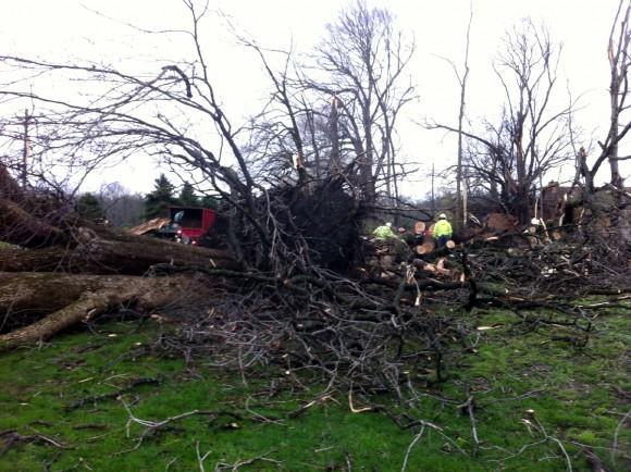
1 Tuscaloosa, Alabama April 27, 2011 Tuscaloosa tornado damage Shot by Bill Castle of ABC 33/40 in Birmingham

2 WELCOME MAY 5, 2011 ALL-MEMBER MEETING
3 Thanks to our host, Subaru of Indiana Automotive (SIA) for the generous use of their facilities, and to Dan, WA9DDI, for helping make it all happen. Let s Keep It Clean Recycle! Leave the room the same way we found it (chairs, tables, etc.) No smoking on property (except in the one designated location)
4 Upcoming Event Dayton Hamvention May 20-22, 2011 (Friday, Saturday, Sunday)
5 Upcoming Event ARES Picnic Saturday, JUNE 11 3:00 6:00 p.m. Munger Park
6 Upcoming Event Field Day June 25-26, 2011 Participate with your local club, a few friends, or on your own
7 Upcoming Event Indianapolis Hamfest Saturday, July 9,
8 Upcoming Event Tippecanoe County 4H Fair July 17-24, 2011 ARES Booth?? Promote amateur radio emergency communications and SKYWARN
9 Upcoming Event Lafayette Hamfest Sunday, August 21,

10 Net Controls Web Page Login required (NCS only) See WR9A to change password Proprietary information Repeater control codes Personal phone numbers Repeater status Special instructions Check often for updates At least weekly
11 Net Report Form Accessible by all To be completed after every ARES net By both primary and alternate Net Controls

12 Indiana D-STAR Repeaters D-STAR in use by ARES Special Icom promotion 2 new systems in the works Possibly a 3rd in Fort Wayne
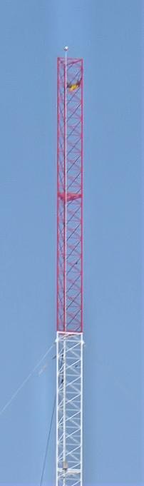
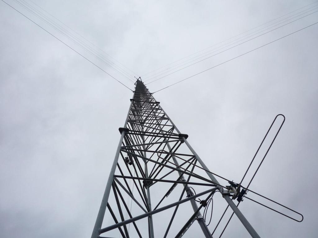
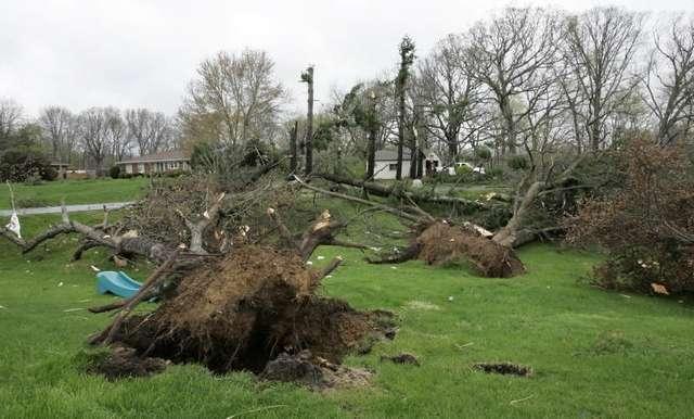
13 Tower Accident - April 13 Two tower workers from Texas lost their lives in a tragic accident in Tippecanoe County on April 13 They were building a 500 tower to replace one that had to be moved for the new Hoosier Heartland Corridor This is the actual call to 911
14

15

16

17

18

19 Tower Accident - April 13
20 Amateur=Professional Travis Null - KC9INH
21 Hazard Analysis Weather conditions Type and condition of supporting structure Scope of work to be performed Number and skill level of helpers Equipment to be used
22 Weather conditions Wind Rain LIGHTNING Heat/Cold
23 Type and condition of supporting structure Towers Roofs Trees Other (what else is there?)
24 Scope of work to be performed Are we raising a yagi or just replacing a feedline. Maybe we just want to climb up & take a look (do this often)
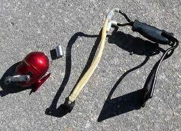
25 Number and skill level of helpers Always have at LEAST one helper, even your wife in a lawn chair Save the beer until the job is done!
26 Equipment to be used Condition Is it appropriate? Are we familiar with it?

27
28

29


30


31 How do we mitigate hazards? Who does what? Contingency planning Rescue plan
32 Hard hat Pants/long sleeve shirt Gloves Eye & hearing protection Fall protection
33 Full body harness (NO POSITIONING BELTS!) Connecting devices Carabiners Shock-absorbing lanyards Self retracting lanyards Y-lanyards Anchor point
34 Fall arrest means stopping a fall within 6 feet Much greater physical forces at work NOT for positioning! Always connected to dorsal d-ring Fall restraint means preventing a fall over 2 feet May be used as positioning
35 Shock absorbing lanyard Y-Lanyard Self Retracting Lifeline Temporary Lifeline Positioning Lanyard Safety Climb Guard Rails Controlled Decent devices

36

37
38 Before EVERY climb! Look for: Signs of wear Missing parts Cracks Loose stitching Proper fit

39 For the purpose of most Amateur operations, your fire department will be the best option. LFD has a 102 platform ladder that will handle most ham stations, if it can get close enough. LFD has training and equipment to perform tower rescues. You should consult with your FD in advance to see that they are available!!!


40
41 Use your legs Don t grasp too tightly Rest often Keep body swing to a minimum
42 100% tie-off Use a Y-lanyard Connect to tower legs Connect above your head
43 Use a positioning device while you work (and fall protection device) Don t drop stuff!
44 Roofs Trees Other (what else is there?)

45

46
47

48

49
50

51
52 Expand Spotter Coverage Dire need for spotters to our west TCARES to expand its SKYWARN responsibility to include Warren and Fountain counties Area of responsibility may expand further with new repeater & increased coverage

53 SKYWARN Spotter Locations Warren & Fountain county sites to be added soon
54 April Tornado Reports
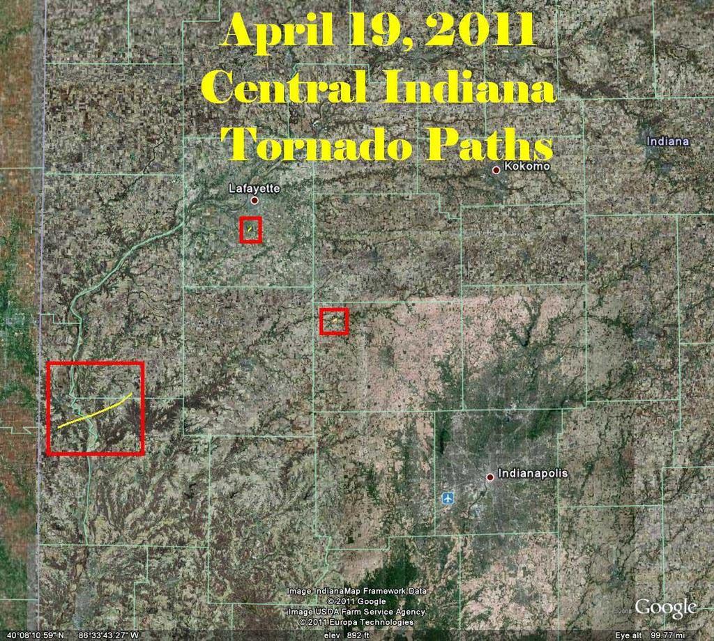
55 April Hail Reports

56 April High Wind Reports
57 April 15 Jackson, MS Clinton, Mississippi: Extreme, up-close video of a violent tornado doing damage west of Jackson, MS on April 15,
58 April 19 Carlinville, IL Extreme up-close video of two strong tornadoes in northeast Missouri into western Illinois on April 19, First tornado was near Bowling Green, MO, and second tornado was just east of Carlinville, IL.
59

60

61


62 April 19


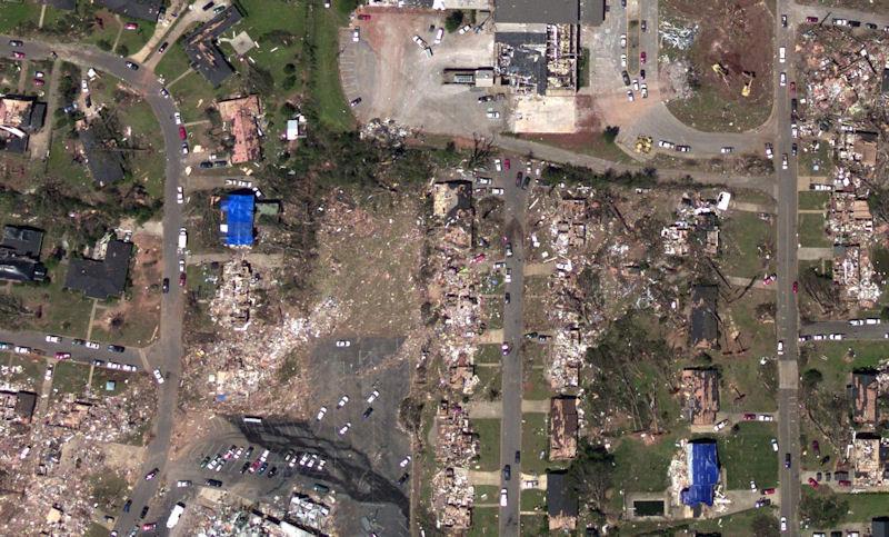
63 April 19
64 Storms in the South This video shows the rapid scan infrared imagery from the GOES-East weather satellite from April 26-28, During severe weather events, such as the past few days, NOAA places GOES into rapid scan mode, taking imagery every 5-15 minutes instead of every 30 minutes to provide forecasters the extra needed information that they need on rapidly evolving situations. The overshooting tops associated with severe storms and tornadoes can be seen over Mississippi, Alabama, Tennessee, and Virginia.

65 Storms in the South
66 April 27 Philadelphia, MS Video of four violent wedge tornadoes from different supercells in eastern Mississippi into Alabama, including the EF-5 that occurred near Philadelphia, Mississippi, as well as the birth of the Tuscaloosa tornado. Sadly, this tornado outbreak over "Dixie Alley" was responsible for substantial loss of life and property across MS, AL, GA, as violent tornadoes struck Tuscaloosa, Birmingham, and other populated areas.
67 April 27 Tuscaloosa, AL

68 NWS Doppler Radar Rotation Tracks

69 NWS

70 Tuscaloosa, AL - BEFORE
71 Tuscaloosa, AL - AFTER

72 Tuscaloosa, AL - Before

73 Tuscaloosa, AL - AFTER

74 Tuscaloosa, AL - BEFORE

75 Tuscaloosa, AL - AFTER

76 Tuscaloosa, AL - BEFORE

77 Tuscaloosa, AL - AFTER
78 April Outbreak 305 tornadoes during the entire outbreak from 08:00 a.m. April 25 through 08:00 a.m. April tornadoes in a 24-hour period (April 27) in 14 states Largest tornado outbreak in U.S. history Number surpassed previous record of 148 tornadoes on April 3, 1974 April 27 outbreak caused 327 deaths 3 rd deadliest outbreak in U.S. history 1925 (747 deaths), 1932 (332 deaths)
79 April Outbreak NWS Activity Plenty of advanced notice NWS SPC issued severe weather outlooks 5 days in advance and tornado watches hours in advance NWS issued warnings for more than 90 percent of the tornadoes Average warning lead time of 24 minutes
80 ARES Volunteers Georgia ARES looking for volunteers to deploy to Alabama for disaster recovery communications DO NOT SELF DEPLOY TO ALABAMA All volunteers MUST register Must be an ARES member in good standing with your resident county EC Those not active in training, and those who have not taken the required NIMS courses, will not be considered deployable Totally self-sustainable for at least 3 days
81 SKYWARN Nets The sole purpose of a SKYWARN net:??? Relay severe weather reports to the NWS
82 Spotter Reporting Every spotter report should contain 4 major pieces of information. What are they?
83 Spotter Reporting WHO you are (give your call sign) WHAT you have seen Be specific & concise: tornado on the ground, funnel cloud, wall cloud with rotation, hail, flash flooding, etc. Describe the storm s direction & speed of travel, size & intensity, & destructiveness. WHEN you saw it Is it occurring now, or 5 or 15 minutes ago? Make sure you note the time of your observation, when you make it WHERE you were when you saw it What is your exact location? In which direction did you observe it? To avoid confusion, make sure you report YOUR location, and the estimated distance and direction of what you observed.
84 Tornado or funnel cloud What to Report Persistent, rotating wall clouds Winds over 40 m.p.h. Any size hail Any major damage caused by the storm Flash flooding (rain rate over 1 per hour) Other data requested by the NWS or the NCS These reporting criteria may change based upon the needs of the moment. Pay close attention to what the Net Control Station is asking for!
85 SKYWARN Net Conditions ARES Net Condition 4 Automatic when a WATCH is issued No net will be initiated (under most circumstances) Weather Radio announcement should make everyone aware of the threat condition WIRES repeater will periodically announce the WATCH
86 SKYWARN Net Conditions ARES Net Condition 3 Authorized by EC/AEC under a WATCH when severe weather will likely threaten Tippecanoe County Directed net to prepare for likely warning ARES Net Condition 2 Automatic when a WARNING is issued Any available NCS should start a SKYWARN net immediately No time to waste a WARNING means that we should have a SKYWARN net up and running with an NWS Liaison active
Net Control Workshop. W9TN Planning AEC 3/12/11
 Net Control Workshop W9TN Planning AEC 3/12/11 Net Control 101 You and Your Station Anyone should be able to figure out which station is the NCS just by listening to the net for a few minutes. Station
WELCOME FEBRUARY 10, 2011 ALL-MEMBER MEETING
 WELCOME FEBRUARY 10, 2011 ALL-MEMBER MEETING Thanks to our host, Subaru of Indiana Automotive (SIA) for the generous use of their facilities, and to Dan, WA9DDI, for helping make it all happen. Let s Keep
WELCOME FEBRUARY 2, 2012 ALL-MEMBER MEETING
 WELCOME FEBRUARY 2, 2012 ALL-MEMBER MEETING Happy Groundhog Day Dayton Hamvention May 18-20, 2012 www.hamvention.org Field Day June 23-24, 2012 Participate with your local club, a few friends, or on your
Kane County Amateur Radio Emergency Service
 This script is to be used when severe weather is approaching or has reached Kane County. The script is divided into three parts. Part One is for use when the National Weather Service has issued a WATCH
Tippecanoe County ARES Net Formats NET 1-4. Net Formats
 1. Introduction Net Formats To provide a basis for carrying out the mission of the Tippecanoe County, Indiana, Amateur Radio Emergency Service (ARES ), guidelines must be in place to meet the communications
Allen County SKYWARN Net Operations Manual
 Allen County SKYWARN Net Operations Manual This page is intentionally blank Allen County SKYWARN Net Ops. Manual Page 2 of 11 24 January 2017 Table of Contents Table of Contents... 3 Purpose... 5 About
THE IMPACT OF WEATHER
 The United States is the most severe weather prone country in the world. Each year, people in this country cope with an average of 10,000 thunderstorms, 5,000 floods, 1,200 tornadoes and two landfalling
GWINNETT COUNTY GEORGIA AMATEUR RADIO EMERGENCY SERVICE. Operations Plan
 GWINNETT COUNTY GEORGIA AMATEUR RADIO EMERGENCY SERVICE Operations Plan National Weather Service Support Plan 100 (Operation SKYWARN) September 21, 2002 (Revised July 14, 2003) National Weather Service
Denton County SKYWARN Guidelines
 Emergency traffic, tornadic activity or weather that is an imminent threat to life and/or property has top priority. Repeater Operations during a Skywarn Net: NOTE: When the repeater announces WEATHER
Appendix E SKYWARN NET CONTROL SCRIPTS WEATHER STATEMENT
 Appendix E SKYWARN NET CONTROL SCRIPTS WEATHER STATEMENT THIS IS WX1GYX, FOR SKYWARN. ARE THERE ANY STATIONS WITH EMERGENCY OR PRIOROTY TRAFFIC? THE NATIONAL WEATHER SERVICE HAS ISSUED A < READ STATEMENT
SKYWARN Reporting via Ham Radio. MSUARC, April 10, 2018 Bill Call, KJ4W with assistance from Christine Wielgos, NWS
 SKYWARN Reporting via Ham Radio MSUARC, April 10, 2018 Bill Call, KJ4W with assistance from Christine Wielgos, NWS Topics What is SKYWARN? How to Select a Good Vantage Point, if Mobile What Phenomena Are
Tornado Preparedness. Monthly Safety Meeting
 Tornado Preparedness Monthly Safety Meeting Introduction Tornadoes can occur anywhere and at any time during the year. In an average year, 800 tornadoes are reported throughout the nation. The most violent
We Had No Warning An Overview of Available Forecast Products Before and During Severe Weather Events
 We Had No Warning An Overview of Available Forecast Products Before and During Severe Weather Events Two main sources for severe weather info NOAA/NWS Storm Prediction Center (SPC) Convective Outlooks
50 th Anniversary of the Oak Lawn Tornado
 50 th Anniversary of the Oak Lawn Tornado 2017 DuPage County Advanced Severe Weather Seminar National Weather Service Chicago Mike Bardou Stephen Rodriguez Outline 1967 Belvidere, Lake Zurich, and Oak
FLOOD/SCS EVENT, APRIL 28 MAY 4
 REPORT DATE: May 4, 2017 EVENT DATE: April 28-May 4, 2017 FLOOD/SCS EVENT, APRIL 28 MAY 4 Event Summary General Significant Flood Outlook. SOURCE: National Weather Service. A significant severe thunderstorm
FANNIN COUNTY A.R.E.S. and R.A.C.E.S. Reference Manual SKYWARN MISSION TO LOCATE POSSIBLE THREATS TO LIFE AND PROPERTY. And
 FANNIN COUNTY A.R.E.S. and R.A.C.E.S. STORM COWBOY Reference Manual SKYWARN MISSION TO LOCATE POSSIBLE THREATS TO LIFE AND PROPERTY And PROVIDE INFORMATION FROM WHICH WARNINGS CAN ISSUED TABLE OF CONTENTS
Inclement Weather Preparedness. Tornadoes and Severe Thunderstorms
 Inclement Weather Preparedness Tornadoes and Severe Thunderstorms Let s find out How do we prepare ahead of time? What is the difference between a watch and a warning? What are the severe weather communications
TORNADO PREPAREDNESS AND INFORMATION MANUAL
 TORNADO PREPAREDNESS AND INFORMATION MANUAL What is a Tornado? A tornado is defined as a violently rotating column of air extending from a thunderstorm to the ground. The most violent tornadoes are capable
2013 Tornado and Severe Weather Awareness Drill
 2013 Tornado and Severe Weather Awareness Drill Scheduled for Thursday April 18, 2013 The 2013 Tornado Drill will consist of a mock tornado watch and a mock tornado warning for all of Wisconsin. This is
STORM COWBOY. FANNIN COUNTY A.R.E.S. and R.A.C.E.S. Reference Manual SKYWARN MISSION
 FANNIN COUNTY A.R.E.S. and R.A.C.E.S. STORM COWBOY Reference Manual SKYWARN MISSION TO LOCATE POSSIBLE THREATS TO LIFE AND PROPERTY AND PROVIDE INFORMATION FROM WHICH WARNINGS CAN ISSUED TABLE OF CONTENTS
BROWARD COLLEGE COMMUNITY & INCIDENT COMMAND TEAMS
 BROWARD COLLEGE COMMUNITY & INCIDENT COMMAND TEAMS Types of Severe Weather Communications about Severe Weather Preparedness Actions Initial Response Actions Community & Incident Command Teams Severe Thunderstorms
Severe Weather Hazards Are Real
 Severe Weather Hazards Are Real In the past 10 years, more than 40 people have died and dozens more injured as a result of weatherrelated events in Minnesota (not including motor vehicles.) The top severe
SURVIVING THE STORM: A Severe Weather Safety Guide for West Texans
 SURVIVING THE STORM: A Severe Weather Safety Guide for West Texans National Weather Service Weather Forecast Office Midland, Texas www.weather.gov/midland Fundamental Definitions WATCH Conditions are favorable
THE SKYWARN NET SCRIPT FOLLOWS SEVERE STORM-SUMMER
 WATCH mode READ EVERY 15 MINUTES on 146.94 Repeater Is the frequency in use? (to break into a conversation, use the Proword SKYWARN ) National Weather Service San Antonio/Austin. All SKYWARN spotters are
Kentucky Weather Hazards: What is Your Risk?
 Kentucky Weather Hazards: What is Your Risk? Stuart A. Foster State Climatologist for Kentucky 2010 Kentucky Weather Conference Bowling Green, Kentucky January 16, 2010 Perspectives on Kentucky s Climate
Unit 5: NWS Hazardous Weather Products. Hazardous Weather and Flooding Preparedness
 Unit 5: NWS Hazardous Weather Products Objectives Describe the mission of the NWS Describe the basic organizational structure of the NWS Explain the purpose of various NWS products Explain how Probability
Information Reception: Decision Support Standards: Public Notification Plan: Protection Program: Education:
 The National Weather Service (NWS) has implemented a voluntary recognition program to help large outdoor venues, including those on university campuses, better protect staff and patrons from the dangers
NOAA s National Weather Service
 NOAA s Basic Concepts of Severe Storm Spotting Ron Riemersma 2012 Rusty Kapela Milwaukee/Sullivan www.weather.gov/mkx rusty.kapela@noaa.gov Housekeeping Duties How many new spotters? - first spotter class
A guide to thunderstorms and how to stay safe when they strike!
 A guide to thunderstorms and how to stay safe when they strike! Thunderstorms, are a violent example of convection. At any given moment, there are an estimated 1,500 thunderstorms in progress somewhere
 STATE OF WISCONSIN/ DEPARTMENT OF MILITARY AFFAIRS WISCONSIN EMERGENCY MANAGEMENT 2400 WRIGHT STREET P.O. BOX 7865 MADISON, WISCONSIN 53707-7865 608-242-3232 February 22, 2007 Re: Tornado and Severe Weather
MET Lecture 29 Tornadoes IV
 MET 4300 Lecture 29 Tornadoes IV Outline Definition, life cycle, & climatology of tornadoes Tornado formation within supercells Tornado formation within nonsupercell thunderstorms Fujita scale Tornado
Natural Disasters PASSAGE 5
 PASSAGE 5 Name Directions: Read Natural Disasters. Then answer questions 1 8. Natural Disasters Our planet can be a calm place, but weather conditions often change rapidly. Gentle breezes can blow into
Advanced Spotter Training Welcome! Lesson 1: Introduction and Why Spotters are Important
 Advanced Spotter Training 2009 Welcome! Lesson 1: Introduction and Why Spotters are Important Introduction This course is intended to advance the basic training given by the National Weather Service (NWS).
HURRICANES AND TORNADOES
 HURRICANES AND TORNADOES The most severe weather systems are hurricanes and tornadoes. They occur in extremely low pressure systems, or cyclones, when the air spirals rapidly into the center of a low.
Review of Basic Severe Thunderstorm & Tornado Spotting Concepts. Jim Allsopp National Weather Service Chicago/Romeoville, IL
 Review of Basic Severe Thunderstorm & Tornado Spotting Concepts Jim Allsopp National Weather Service Chicago/Romeoville, IL Why Do We Need Spotters? Radar has limitations, only spotters can provide view
CONTACT SAFETY PROGRAM MAY 2006
 State of Nevada Mine Safety and Training Section Phone: 775-684-7085 Fax: 775-687-8259 Email: mines@dbi.state.nv.us Web: www.dirweb.state.nv.us/msts.htm CONTACT SAFETY PROGRAM MAY 2006 Lightning causes
GC Briefing. Weather Sentinel Tropical Storm Michael. Status at 8 AM EDT (12 UTC) Today (NHC) Discussion. October 11, 2018
 Today (NHC) Discussion. October 11, 2018") GC Briefing Weather Sentinel Tropical Storm Michael October 11, 2018 After making landfall as a high-end category-4 hurricane on the Florida Panhandle, Michael weakened to tropical storm status early this
GC Briefing Weather Sentinel Tropical Storm Michael October 11, 2018 After making landfall as a high-end category-4 hurricane on the Florida Panhandle, Michael weakened to tropical storm status early this
Severe Weather Watches, Advisories & Warnings
 Severe Weather Watches, Advisories & Warnings Tornado Watch Issued by the Storm Prediction Center when conditions are favorable for the development of severe thunderstorms and tornadoes over a larger-scale
Storm Spotting Operating Procedure
 Storm Spotting Operating Procedure OVERVIEW Volunteer severe storm spotters serve an important function in the system of severe storm warning in the Kansas City area. Dedicated ham operators, with their
Claim: Global warming is causing more and stronger tornadoes REBUTTAL
 Claim: Global warming is causing more and stronger tornadoes REBUTTAL Tornadoes are failing to follow global warming predictions. Strong tornadoes have seen a drop in frequency since the 1950s. The years
Impact Based Warning Tornado - Infrastructure
 National Weather Service Impact Based Warning Tornado - Infrastructure Jim Kramper Warning Coordination Meteorologist St. Louis, MO NOAA s National Weather Service 2011 was a devastating year for tornado
Tornadoes Student Activity Book
 Tornadoes Student Activity Book I. Introduction Have you ever seen a tornado? Hopefully, it was in a video on television. Each year as many as 1000 tornadoes may occur in the United States. Their destruction
Tornadoes pose a high risk because the low atmospheric pressure, combined with high wind velocity, can:
 Tornadoes are powerful, circular windstorms that may be accompanied by winds in excess of 200 miles per hour. Tornadoes typically develop during severe thunderstorms and may range in width from several
IN VEHICLES: Do not try to outrun a tornado. Abandon your vehicle and hide in a nearby ditch or depression and cover your head.
 TORNADO SAFETY TORNADO! The very word strikes fear in many people. While a tornado is perhaps nature's most destructive storm, deaths and injuries can be prevented. By following Tornado Safety Rules, lives
Tornadoes Module 2. - Tornado Watch -
 1 2 - Tornado Watch - Issued by the National Weather Service when tornadoes are possible in an area Remain alert for approaching storms Remind family/employees of location of safest places Listen to the
State Of Wisconsin. Department of Military Affairs. Division of Emergency Management
 State Of Wisconsin Department of Military Affairs Division of Emergency Management Brian M. Satula Administrator Scott Walker Governor For more information contact: Tod Pritchard Office: 608-242-3324 Cell:
Severe Thunderstorms
 Severe Thunderstorms Severe Thunderstorms Explain that, while all thunderstorms are dangerous, the National Weather Service (NWS) defines a severe thunderstorm as one that: Display Slide Th-0 Produces
Building A Weather-Ready Nation
 Building A Weather-Ready Nation Steve Runnels National Weather Service Springfield, MO` Photo Credit: Tim Marshall 122 National Weather Service Offices NWS Offices Service Missouri and Warning Coordination
While all thunderstorms are dangerous, the National Weather Service (NWS) defines a severe thunderstorm as one that:
 defines a severe thunderstorm as one that:") While all thunderstorms are dangerous, the National Weather Service (NWS) defines a severe thunderstorm as one that: Produces hail at least three-quarters of an inch in diameter. Has winds of 58 miles
While all thunderstorms are dangerous, the National Weather Service (NWS) defines a severe thunderstorm as one that: Produces hail at least three-quarters of an inch in diameter. Has winds of 58 miles
StormReady Supporter Application Form updated by NWS Chanhassen on April 7, Name of Applying Entity: Point of Contact: Title:
 NATIONAL WEATHER SERVICE 1733 Lake Drive West Chanhassen, Minnesota www.weather.gov/twincities www.stormready.noaa.gov 952-361-6671, todd.krause@noaa.gov StormReady Supporter Application Form updated by
TORNADO/high winds *
 TORNADO/high winds * WATCH Bring people inside. Secure outside objects. Clear window ledges & wall hangings Close drapes Protect windows Assemble and check supplies Call in applicable staff Pre-Storm:
LECTURE #15: Thunderstorms & Lightning Hazards
 GEOL 0820 Ramsey Natural Disasters Spring, 2018 LECTURE #15: Thunderstorms & Lightning Hazards Date: 1 March 2018 (lecturer: Dr. Shawn Wright) I. Severe Weather Hazards focus for next few weeks o somewhat
tornadoes in oklahoma Christi HAgen
 tornadoes in oklahoma Christi HAgen 17 Introduction Tornadoes are some of the world s most severe phenomena. They can be miles long, with wind speeds over two hundred miles per hour, and can develop in
Village Weather, Snow, Ice, Breakup, Flooding, Fire sites
 Village Weather, Snow, Ice, Breakup, Flooding, Fire sites What is the weather like now in Villages?... 1 BREAKUP:... 2 Flooding... 3 Fires... 5 Weather Predictability, Weather and Ice Advisories and How
NOAA s National Weather Service. National Weather Service
 NOAA s National Weather Service Serving the Nation s Environmental Forecasting Needs Lynn Maximuk Regional Director National Weather Service Central Region Headquarters Kansas City, Missouri America s
State Of Wisconsin Department of Military Affairs
 State Of Wisconsin Department of Military Affairs Division of Emergency Management Brian M. Satula Administrator Scott Walker Governor For more information contact: Tod Pritchard Office: 608-242-3324 Cell:
COMMUNITY EMERGENCY RESPONSE TEAM TORNADOES
 Tornadoes are powerful, circular windstorms that may be accompanied by winds in excess of 200 miles per hour. Tornadoes typically develop during severe thunderstorms and may range in width from several
WEDNESDAY 30 TH AUGUST, :57 p.m. Tropical Storm Irma forms in the Atlantic. Don t let your guard down, always #Be Ready.
 Chapter 1 - The Set Up In the days leading up to Irma a series of composed and sobering text messages, presented in truncated form below, from Department of Disaster Management warned us of the pending
Tornadoes. Be able to define what a tornado is. Be able to list several facts about tornadoes.
 Tornadoes Be able to define what a tornado is. Be able to list several facts about tornadoes. 1. Where do tornadoes most U.S. is # 1 occur in the world? Tornadoes are most common in Tornado Alley. Tornado
Storm Chasers LEVELED READER R. Visit for thousands of books and materials.
 Storm Chasers A Reading A Z Level R Leveled Reader Word Count: 1,176 LEVELED READER R Written by Linda Johns Visit www.readinga-z.com for thousands of books and materials. www.readinga-z.com Storm Chasers
Thursday, September 6, :30 a.m. EDT
 Thursday, September 6, 2018 8:30 a.m. EDT Significant Activity Sep 5-6 Significant Events: Tropical Depression Gordon Tropical Activity: Atlantic Tropical Depression Gordon; Hurricane Florence (CAT 3);
NEWARN Tabletop Exercise Norfolk, Nebraska
 NEWARN Tabletop Exercise Norfolk, Nebraska August 21, 2012 Participant Situation Manual Sponsored by: U.S. EPA and NEWARN Facilitated by: The Horsley Witten Group, Inc. TABLE OF CONTENTS Subject Page Exercise
United States Multi-Hazard Early Warning System
 United States Multi-Hazard Early Warning System Saving Lives Through Partnership Lynn Maximuk National Weather Service Director, Central Region Kansas City, Missouri America s s Weather Enterprise: Protecting
3 Severe Weather. Critical Thinking
 CHAPTER 2 3 Severe Weather SECTION Understanding Weather BEFORE YOU READ After you read this section, you should be able to answer these questions: What are some types of severe weather? How can you stay
Charles Kuster Leadville, CO. Personal Overview
 Charles Kuster Leadville, CO Personal Overview Personal Overview Charles Kuster Leadville, CO OU to study meteorology Charles Kuster Leadville, CO Personal Overview OU to study meteorology Graduated in
LIGHTNING SAFETY #24 CONSTRUCTION SAFETY EDUCATION PROGRAM
 CONSTRUCTION SAFETY EDUCATION PROGRAM #24 LIGHTNING SAFETY This education program provides general information on Lightning Safety. It is intended to give contractors and workers practical information
1879-LDG-E. Leader s Guide
 ERI Safety Videos Videos for Safety Meetings 1879-LDG-E SEVERE WEATHER ALERT: ARE YOU PREPARED? Leader s Guide 2003, ERI Safety Videos SEVERE WEATHER ALERT: ARE YOU PREPARED? This easy-to-use Leader s
Radar Meteorology AOS 444 October 28, 2002 Laboratory 6: WATADS study of Oakfield tornado from KGRB
 Radar Meteorology AOS 444 October 28, 2002 Laboratory 6: WATADS study of Oakfield tornado from KGRB YOUR NAME: YOUR PARTNER S NAME: On July 18, 1996 the town of Oakfield, Wisconsin was all but destroyed
CHASING TORNADOES by Tim Marshall (published in Weatherwise Magazine, August 1983, photos added)
") CHASING TORNADOES by Tim Marshall (published in Weatherwise Magazine, August 1983, photos added) Tornado is an all-too-familiar word to the folks in West Texas. Each spring, atmospheric conditions favorable
CHASING TORNADOES by Tim Marshall (published in Weatherwise Magazine, August 1983, photos added) Tornado is an all-too-familiar word to the folks in West Texas. Each spring, atmospheric conditions favorable
10 years after Hurricane Charley
 10 years after Hurricane Charley Hurricane Charley (2004) A Retrospective Scott M. Spratt Warning Coordination Meteorologist NWS Melbourne, FL Florida Governors Hurricane Conference May 15, 2014 11 AM
Safety Issue: Types of weather emergencies and natural. Weather Emergencies
 Overview Safety Issue: Rapid and effective response to weather emergencies and other natural disasters whether during or after work hours takes forethought and careful planning. Types of weather emergencies
Daily Operations Briefing Wednesday, April 5, :30 a.m. EDT
 Daily Operations Briefing Wednesday, April 5, 2017 8:30 a.m. EDT Significant Activity Apr 4-5 Significant Events: Severe Weather Southern Plains to Southeast Significant Weather: Severe thunderstorms &
Hurricane Matthew Threats and Impacts Briefing for Eastern NC
 Hurricane Matthew Threats and Impacts Briefing for Eastern NC October 6 th, 2016 Date/Time Created: 10/6/2016, Noon EDT National Weather Service Newport/Morehead City, NC Hurricane Matthew Key Points Changes
The Integrated Warning Partnership: Opportunities for Improved Community-Level Benefits. Dale Morris Oklahoma Climatological Survey April 18, 2006
 The Integrated Warning Partnership: Opportunities for Improved Community-Level Benefits Dale Morris Oklahoma Climatological Survey April 18, 2006 My Personal Motivation Sunday Evening, September 5, 1992
Daily Operations Briefing. Tuesday, July 4, :30 a.m. EDT
 Daily Operations Briefing Tuesday, July 4, 2017 8:30 a.m. EDT Significant Activity July 3-4 Significant Events: None Tropical Activity: Atlantic Disturbance 1: High (80%) Eastern Pacific Disturbance 1:
Complete Weather Intelligence for Public Safety from DTN
 Complete Weather Intelligence for Public Safety from DTN September 2017 White Paper www.dtn.com / 1.800.610.0777 From flooding to tornados to severe winter storms, the threats to public safety from weather-related
SPEARFISH FIRE DEPARTMENT POLICIES AND PROCEDURES
 SPEARFISH FIRE DEPARTMENT POLICIES AND PROCEDURES Page 1 of 5 Volume: Operation Section: 20.00 Number: 20.09 Subject: Weather Watches, Warnings, Advisory s and Spotter Activation Date Issued: 28 March
Situation Manual Protective Actions
 Situation Manual Protective Actions 175 Minutes Situation Manual Tabletop Exercise 1 Disaster Resistant Communities Group www.drc-group.com Tallahassee Twister Start Exercise No Image During the exercise
The National Oceanic and Atmospheric Administration (NOAA) National Weather Service (NWS) Severe Thunderstorm Observing and Radar Monitoring
 National Weather Service (NWS) Severe Thunderstorm Observing and Radar Monitoring") The National Oceanic and Atmospheric Administration (NOAA) Presents National Weather Service (NWS) Severe Thunderstorm Observing and Radar Monitoring Severe Weather Spotter Line 1-888-668-3344 Spotter
The National Oceanic and Atmospheric Administration (NOAA) Presents National Weather Service (NWS) Severe Thunderstorm Observing and Radar Monitoring Severe Weather Spotter Line 1-888-668-3344 Spotter
Your Task: Read each slide then use the underlined red or underlined information to fill in your organizer.
 Severe Weather: Tornadoes and Hurricanes Thunderstorms and Lightning S6E4 d. Construct an explanation of the relationship between air pressure, weather fronts, and air masses and meteorological events
Tornadoes. Tornadoes COMMUNITY EMERGENCY RESPONSE TEAM TORNADOES
 Tornadoes Tornadoes Tell the participants that tornadoes are powerful, circular windstorms that may be accompanied by winds in excess of 200 miles per hour. Tornadoes typically develop during severe thunderstorms
National Situation Report As of 5:00 a.m. EDT Wednesday, April 5, 2017
 Overview National Situation Report As of 5:00 a.m. EDT Wednesday, April 5, 2017 Table Of Contents Current Operations Monitoring Recovery National Response Coordination Center: Not Activated National Watch
Daily Disaster Update Sunday, September 04, 2016
 Daily Disaster Update Information distributed to Disaster Notifications should be shared outside of the American Red Cross for business and mission critical purposes only please be wise when sharing information
The Greensburg Miracle Where There s Life, There s Hope. Michael R. Smith, C.C.M. CEO, WeatherData Services, Inc. Wichita, Kansas
 The Greensburg Miracle Where There s Life, There s Hope Michael R. Smith, C.C.M. CEO, WeatherData Services, Inc. Wichita, Kansas Introduction For a period of approximately 75 years, from 1880 through 1955,
Information Overload! How To Get and Stay Informed During Severe Wx Season
 Information Overload! How To Get and Stay Informed During Severe Wx Season About Brandon Grew up in Macomb, IL Grew interested in spotting/ham radio Volunteer Fire Fighter/First Responder Moved to Oklahoma
Daily Operations Briefing. Tuesday, March 27, :30 a.m. EDT
 Daily Operations Briefing Tuesday, March 27, 2018 8:30 a.m. EDT Significant Activity Mar 26-27 Significant Events: None Tropical Activity: Western Pacific No activity affecting U.S. interests Significant
Comprehensive Emergency Management Plan
 Comprehensive Emergency Management Plan Section 6- Severe Weather/Wildfire Annex Blank Intentionally 2 CEMP Annex 6 11 Severe Weather / Wildfire Annex I. PURPOSE This plan outlines the procedures to be
Daily Operations Briefing. Tuesday, June 27, :30 a.m. EDT
 Daily Operations Briefing Tuesday, June 27, 2017 8:30 a.m. EDT Significant Activity June 26-27 Significant Events: None Tropical Activity: Atlantic Disturbance 1: Low (near 0%) Eastern Pacific Hurricane
Daily Operations Briefing. Saturday, May 13, :30 a.m. EDT
 Daily Operations Briefing Saturday, May 13, 2017 8:30 a.m. EDT Significant Activity May 12-13 Significant Events: None Significant Weather: Flash Flooding possible Northern NJ and New York City Fire Weather:
Storm Hazards covered in this course
 Chasing Tornadoes (LG: 3a) A video Teaser, while students enter the classroom. Day3-60 Tornadoes of 2016 (16:05) Pecos Hank channel https://www.youtube.com/watch?v=nzmtglwx0n4 Watch on your own: 2016 and
Annex B Natural No-Notice Event
 Annex B Natural No-Notice Event Version: 1.0 Effective: 10/01/2015 Revision Date: 10/01/2015 Approved By: John Pitcher Purpose The purpose of Natural No-Notice Event Annex is to ensure the safety of BHCC
Saturday, June 9, :30 a.m. EDT
 Saturday, June 9, 2018 8:30 a.m. EDT Significant Activity June 8-9 Significant Events: None Tropical Activity: Atlantic No tropical cyclones expected next 48 hours Eastern Pacific Hurricane Aletta; Disturbance
Thursday, June 7, :30 a.m. EDT
 Thursday, June 7, 2018 8:30 a.m. EDT Significant Activity June 6-7 Significant Events: None Tropical Activity: Atlantic No tropical cyclones expected next 48 hours Eastern Pacific Disturbance 1 (Low 40%);
National Situation Report As of 3:00 a.m. EDT, Friday, June 15, 2018 Table of Contents Current Operations Monitoring Recovery Operations
 Overview National Situation Report As of 3:00 a.m. EDT, Friday, June 15, 2018 Table of Contents Current Operations Monitoring Recovery Operations FEMA Headquarters Status FEMA Region I - X Status NWC Steady
Tropical Update. 5 PM EDT Sunday, September 10, 2017 Hurricane Irma, Hurricane Jose, Tropical Wave (60%)
") Tropical Update 5 PM EDT Sunday, September 10, 2017 Hurricane Irma, Hurricane Jose, Tropical Wave (60%) This update is intended for government and emergency response officials, and is provided for informational
Tropical Update 5 PM EDT Sunday, September 10, 2017 Hurricane Irma, Hurricane Jose, Tropical Wave (60%) This update is intended for government and emergency response officials, and is provided for informational
Chicagoland Skywarn Issue 2, Volume 1 July 2009
 Issue 2, Volume 1 July 2009 Special Interest Articles: Weather or-not The APRS Network and Severe Weather Reporting Lake Michigan Water Temperatures Finally Begin to Heat Up Individual Highlights: Liaison
El Niño & Expected Florida Severe Weather
 El Niño & Expected Florida Severe Weather Brady Smith, AICP, CFM Tampa Bay Regional Planning Council brady@tbrpc.org ONE BAY Resilient Communities Working Group Meeting February 5, 2016 El Niño & Expected
EVALUATION AND VERIFICATION OF PUBLIC WEATHER SERVICES. Pablo Santos Meteorologist In Charge National Weather Service Miami, FL
 EVALUATION AND VERIFICATION OF PUBLIC WEATHER SERVICES Pablo Santos Meteorologist In Charge National Weather Service Miami, FL WHAT IS THE MAIN DIFFERENCE BETWEEN A GOVERNMENT WEATHER SERVICE FORECAST
Winter Weather. National Weather Service Buffalo, NY
 Winter Weather National Weather Service Buffalo, NY Average Seasonal Snowfall SNOWFALL = BIG IMPACTS School / government / business closures Airport shutdowns/delays Traffic accidents with injuries/fatalities