AIR SAFETY INVESTIGATION Boeing , VH-TJX Brisbane, Qld
|
|
|
- Cornelia Page
- 6 years ago
- Views:
Transcription

1 AIR SAFETY INVESTIGATION Boeing , VH-TJX Brisbane, Qld 18 January 2001
2 Department of Transport and Regional Services Australian Transport Safety Bureau INVESTIGATION REPORT Boeing , VH-TJX Brisbane, QLD 18 January, 2001 Released under the provisions of Section 19CU of Part 2A of the Air Navigation Act 1920.
3 ISBN August 2002 This report was produced by the Australian Transport Safety Bureau (ATSB), PO Box 967, Civic Square ACT Readers are advised that the ATSB investigates for the sole purpose of enhancing safety. Consequently, reports are confined to matters of safety significance and may be misleading if used for any other purpose. ii
4 CONTENTS INTRODUCTION v EXECUTIVE SUMMARY 1 1. FACTUAL INFORMATION Sequence of events Injuries to persons Damage to aircraft Other damage Personal information Aircraft information Meteorological information Aids to navigation Communications Aerodrome information Flight recorders Wreckage and impact information Medical and pathological information Fire Survival aspects Tests and research Organisational information Additional information ANALYSIS Introduction Aircraft Flight crew Bureau of Meteorology Air Traffic Services Analysis of the thunderstorm CONCLUSIONS Findings Significant factors SAFETY ACTION 71 APPENDIXES 77 Appendix 1 Airborne weather radar 77 Appendix 2 Instability indices 78 Appendix 3 Bureau of Meteorology weather warning products 80 Appendix 4 NTSB Recommendations relating to hazardous weather operations 82 Appendix 5 SSFDR data plots 84 iii
5 iv
6 INTRODUCTION The Australian Transport Safety Bureau (ATSB) is an operationally independent multimodal Bureau within the Commonwealth Department of Transport and Regional Services. ATSB investigations are independent of regulatory, operator or other external bodies. In terms of aviation, the ATSB is responsible for investigating accidents, serious incidents, incidents and safety deficiencies involving civil aircraft operations in Australia, as well as participating in overseas investigations of accidents and serious incidents involving Australian registered aircraft. The ATSB also conducts investigations and studies of the aviation system to identify underlying factors and trends that have the potential to adversely affect safety. A primary concern is the safety of commercial air transport, with particular regard to fare-paying passenger operations. The ATSB performs its aviation functions in accordance with the provisions of the Air Navigation Act 1920, Part 2A. Section 19CA of the Act states that the object of an investigation is to determine the circumstances surrounding any accident, serious incident, incident or safety deficiency to prevent the occurrence of other similar events. The results of these determinations form the basis for safety recommendations and advisory notices, statistical analyses, research, safety studies and ultimately accident prevention programs. As with equivalent overseas organisations, the ATSB has no power to implement its recommendations. It is not the object of an investigation to determine blame or liability. However, it should be recognised that an investigation report must include factual material of sufficient weight to support the analysis and conclusions reached. That material will at times contain information reflecting on the performance of individuals and organisations, and how their actions may have contributed to the outcomes of the matter under investigation. At all times the ATSB endeavours to balance the use of material that could imply adverse comment, with the need to properly explain what happened, and why, in a fair and unbiased manner. The 24-hour clock is used in this report to describe the Brisbane local time of day, Eastern Standard Time (EST), as particular events occurred. Eastern Standard Time was Coordinated Universal Time (UTC) + 10 hours. Times are accurate to within 30 seconds of reported or recorded events 1. 1 Times for recorded flight data (elapsed timeframes) and meteorological data (UTC) have been converted to EST to assist the reader. v
7 vi
8 EXECUTIVE SUMMARY On 18 January 2001, VH-TJX, a Boeing aircraft, encountered microburst windshear at 0729 EST while conducting a go-around from runway 19 at Brisbane aerodrome 2 during an intense thunderstorm. The aircraft was operating a scheduled fare-paying passenger service from Sydney to Brisbane. As the aircraft passed 1,000 ft during the landing approach, it encountered rain and some isolated hail. The approach lights for runway 19 were visible to the crew, and the pilot in command elected to continue the approach. At about 500 ft, the weather deteriorated rapidly, and the aircraft encountered hail and turbulence. The pilot in command discontinued the approach and applied go-around engine thrust. The aircraft commenced to climb normally at about 3,600 ft/min, however, shortly after the go-around was initiated, the climb performance substantially reduced to less than 300 ft/min due to the effects of the microburst downdraft and from flight through heavy rain. The pilot in command applied maximum engine thrust to improve the aircraft s climb performance, and advised the Aerodrome Controller that the aircraft had encountered severe windshear. The crew then diverted the aircraft to Maroochydore, where it landed without further incident. The Bureau of Meteorology (BoM) issues severe thunderstorm warnings to the public when their intensity is expected to produce dangerous phenomena, such as hail with a diameter of more than 2 cm, wind gusts in excess of 90 kph (48.5 kts), flash floods, and tornadoes. BoM issued severe thunderstorm warnings for the Brisbane area to the public at 0552 and At 0635, BoM issued a warning for Brisbane aerodrome, forecasting the presence of thunderstorms with possible hail and gusts exceeding 41 kts between 0700 and At 0715 BoM issued a lightning alert for Brisbane aerodrome. There was no requirement for Airservices Australia to receive such aerodrome warnings or lightning alerts from the BoM, and they did not do so. The Brisbane aerodrome forecast, issued by BoM at 2021 on 17 January, contained information that thunderstorms with associated gusts of 42 kts were expected in the vicinity of Brisbane aerodrome until 0300 on the 18 January. At 0213 on 18 January, BoM issued an amended forecast for Brisbane aerodrome. The amended forecast was valid until 0400 on 19 January, and contained no information to suggest that thunderstorms were likely in the vicinity of Brisbane aerodrome throughout the forecast period. At 0613, TJX commenced pushback at Sydney, and became airborne at 0622 for the flight to Brisbane. The crew relied on the 0213 amended aerodrome forecast issued by BoM, and was not aware of the 0552 public weather warning concerning the severe thunderstorms south of Brisbane. At 0630, BoM issued a routine aerodrome report for Brisbane aerodrome that superseded the amended aerodrome forecast that was issued at The trend type forecast appended to the routine aerodrome report included information that 2 The term aerodrome is used in this report to define an area of land (including any buildings, installations and equipment) used either wholly or in part for the arrival, departure and surface movement of aircraft. 1
9 thunderstorms and rain showers were forecast during the period 0700 to The controllers received that forecast at 0636 but did not pass it to the crew of TJX at any stage. The aviation-related forecasts for Brisbane aerodrome did not refer to thunderstorms from 0213 until 0630, and the 0630 forecast did not contain information about the phenomenon associated with severe thunderstorms that was included in the public forecasts or in the 0635 aerodrome warning. BoM s forecasting staff used different criteria for the issue of public weather warnings and aerodrome terminal forecasts. Public weather warnings were issued for the Brisbane metropolitan area whenever radar or other evidence indicated that severe thunderstorms were present in, or expected to enter, the designated warning area. The Brisbane aerodrome terminal forecast was a statement of meteorological conditions expected for a specified period in the airspace within a radius of five nautical miles of the centre of the aerodrome. The public weather and aviation products could therefore at times present different information. The air traffic controllers at Brisbane relied on information contained in aerodrome forecasts, routine aerodrome weather reports, and trend type forecasts issued by the Bureau of Meteorology for Brisbane aerodrome. The controllers also relied on weather radar images from the BoM weather radars. The information provided to controllers from those images was to be used in conjunction with other weather information, including that derived from airborne and other observations, to assist pilots with decision making. For some time before the occurrence, air traffic controllers in the Brisbane aerodrome control tower were concerned about the visual appearance of the approaching thunderstorm, and its image on their weather radar display. However, the terminology and language used by air traffic controllers did not convey their concerns about the intensity of the thunderstorm to the crew of TJX until the aircraft was on final approach. The Manual of Air Traffic Services required controllers to pass hazard alert information as soon as practical to aircraft likely to be affected by known hazards. Had the controllers been provided with the aerodrome warnings and lightning alerts, that additional information may have assisted them in determining if a thunderstorm hazard alert should have been issued to the crews of approaching aircraft. In this occurrence there was no effective mutual exchange of information between the controllers and the crew. Had the controllers provided relevant information about the storm to the crew, the crew may have been in a better position to determine whether it was advisable to discontinue the flight towards an area of hazardous weather. The crew s decision to continue the approach may have been influenced by their sighting of the aerodrome when they were on the downwind leg, and the runway 19 lighting system while on final approach. In previous weather-related occurrences, crews have attempted to land because they had visual contact with the runway environment. Investigation of those occurrences found that crew decisions to continue the approach and landing may have been more compelling than the deteriorating weather they were approaching. The occurrence was regarded as a serious incident in accordance with Annex 13 to the Convention on International Civil Aviation. It again highlights that thunderstorms and convective activity in terminal areas are a significant issue in Australian and international aviation. It also illustrates the significant adverse effect of heavy rain on aircraft performance. The hazards associated with those weather conditions are not 2
10 solely confined to the presence of severe thunderstorms, and should not be underestimated. Whenever thunderstorm activity is forecast, there is a potential for microburst windshear and heavy rain. Aircraft in the landing, take-off, missed approach or goaround phases of flight are particularly vulnerable in or near thunderstorms. The effects of microburst windshear and, to a lesser extent, the aerodynamic penalties imposed by flight through heavy rain, can place an aircraft in a potentially-high-risk situation. This serious incident also highlights that without extensive Doppler weather radar capabilities, and in the absence of appropriate systems designed to detect hazardous wind shear in Australia, there is a need for collaborative decision making among forecasters, controllers, pilots and operators during periods of intense or severe convective weather. 3
11 4
12 1. FACTUAL INFORMATION 1.1 Sequence of events 17 January The Bureau of Meteorology (BoM) issued an aerodrome forecast (TAF) for Brisbane aerodrome, valid for the period 2200 on 17 January until 2200 on 18 January. The TAF was a statement of meteorological conditions expected for a specified period in the airspace within a radius of five nautical miles of the centre of Brisbane aerodrome. It indicated the presence of thunderstorms with associated gusts of 42 kts during the period 2200 on 17 January 2001, until 0300 on 18 January 2001, with a requirement for 60 minutes holding during that period. It also indicated the presence of rain and showers between 0300 and 2200 on 18 January 2001, with a requirement for 30 minutes holding during that period. 18 January BoM issued an amended TAF for Brisbane aerodrome, valid for the period 0400 on 18 January 2001 until 0400 on 19 January It indicated the wind direction and speed of 340 degrees (true) at 8 kts, visibility of 10 km, FEW (1 to 2 OKTAS) of cloud at 1,500 ft, and SCT (3 to 4 OKTAS) of cloud at 2,500 ft. The TAF also indicated that from 0900 the wind direction and speed were expected to be 170 degrees (true) at 15 kts, Visibility of 3,000 m in rain showers was forecast, with BKN (5 to 7 OKTAS) cloud at 1,200 ft. Thirty minutes holding was specified for the period 0900 on 18 January 2001 to 0400 on 19 January Comment: The amended TAF did not indicate the presence of thunderstorms in the Brisbane area. The BoM aviation forecaster and the shift-supervising meteorologist considered there was less than a 30 per cent probability of thunderstorms during the period covered by the amended TAF. They based their decision on the fact that it was approaching the time of day when thunderstorms were least likely to occur. Also, there was little upstream thunderstorm activity observed on the BoM weather radar, and the observed upstream thunderstorm activity was decaying BoM issued a Lightning Alert for ground staff at Brisbane aerodrome 4. The alert noted that thunderstorms and lightning had been observed just greater than 15 NM from the aerodrome, and that the storms were expected to pass just to the north of the aerodrome Thunderstorms were observed about 100 km south-west of Brisbane on the BoM Brisbane weather radar. They were growing rapidly and moving eastnorth-east, and were expected to pass to the south of Brisbane. 3 Eastern Standard Time. 4 Airservices Australia did not receive Lightning Alerts issued by BoM, nor was it required to. 5
13 0552 BoM issued a Severe Thunderstorm Warning to the public 5, advising that an area of thunderstorms with damaging winds and large hail had been observed on the southern border ranges south of Boonah. The warning advised that the storms were moving east at about 50 km/hr, and that they were expected to move toward the coast over the next hour or so The BoM weather radar revealed that a thunderstorm had developed about 60 km south-southwest of Brisbane on the northern flank of an existing area of thunderstorms TJX commenced pushback from the Sydney domestic terminal for its flight to Brisbane, eight minutes behind its scheduled departure time. 0622:20 TJX departed Sydney (airborne time) BoM issued TTF METAR 6 for Brisbane aerodrome. It forecast the presence of thunderstorms and rain showers (TSRA) during the period 0700 to BoM issued an aerodrome warning for Brisbane aerodrome that forecast the presence of thunderstorms with possible hail and wind-gusts in excess of 41 kts between 0700 and Brisbane ATC received the TTF that was issued by BoM at 0630, but the controllers did not pass the revised information to the crew of TJX. 0640:00 Brisbane tower controllers issued automatic terminal information service (ATIS) Juliet. It included information on current wind direction and speed, cloud and visibility. Runway 01 was the nominated runway for departures, with runway 01 or 14 being nominated for arrivals. Comment: ATIS Juliet did not include information that thunderstorms were present in the Brisbane area. 0641:30 The Brisbane Tower Coordinator and the Approach Control Coordinator discussed the weather that was approaching Brisbane from the south-west. It s definitely serious there s lots of lightning in that stuff down on the RAPIC 8 past Archerfield BoM issued a Severe Thunderstorm Warning to the public. It reported that several thunderstorms with possible damaging winds and large hail had been observed from the near south-west of Brisbane extending to the northern Gold Coast area, and that they were moving north-east at about 70 km/hour. 5 Airservices did not receive Severe Thunderstorm Warnings issued to the public by BoM, nor was it required to. 6 The identifier METAR is used for a routine aerodrome weather report. The identifier TTF is used for a Trend Type Forecast, which is a statement of trend appended to a METAR. SPECI is the identifier for other non-routine weather observations. 7 Airservices did not receive aerodrome warnings issued by BoM, nor was it required to. 8 RAdar PICture. This is discussed in subsections and All quotes in subsection 1.1 of this report were sourced from air traffic control automatic voice recordings. 6
14 0655:50 The Brisbane Aerodrome Controller and Approach Coordinator discussed the approaching weather. They agreed that they would need to change the active runway from 01, because arriving aircraft would not wish to fly through the weather that was currently over Archerfield aerodrome, located 14 NM south-southwest of Brisbane aerodrome. Brisbane doesn t look too hot from here BoM issued a TTF METAR for Brisbane aerodrome. It included information that lightning had been observed to the south of the aerodrome, and the appended trend continued to forecast thunderstorms and rain (TSRA) for the period 0700 to :55 TJX left FL 350 on descent into Brisbane. 0703:00 The crew of TJX transferred to the Gold Coast Sector Controller, who advised them that because of weather, previous aircraft inbound to Brisbane from the south had tracked overhead and then to about 20 NM north of Coolangatta before tracking towards Brisbane. Looks like the way to go. (Crew of TJX) 0706:30 Brisbane ATIS Kilo was issued. It included information on current wind direction and speed, cloud and visibility. Runway 19 was the nominated runway for departures and arrivals. Comment: ATIS Kilo did not include information that thunderstorms were present in the Brisbane area Brisbane ATC received the TTF that was issued by BoM at :30 Brisbane ATIS Lima was issued. It included information on current wind direction and speed, cloud and visibility, and that a thunderstorm was approaching from the south. Runway 19 was the nominated runway for departures and arrivals. 0710:40 The Approach Coordinator called the Tower Coordinator to advise of the latest weather conditions at Archerfield. And for info the last speci for Archerfield 32 kts coming through from [garbled] The Gold Coast Sector Controller provided the crew of TJX with details of ATIS information Lima BoM issued a Lightning Alert for Brisbane aerodrome. It noted that thunderstorms and lightning had been observed within 15 NM of the aerodrome, and that the storms were expected to move to within 5 NM of the aerodrome before clearing within the next hour. 0715:30 The Gold Coast Sector Controller advised the crew of TJX to contact the Approach South controller on frequency Mhz. 0716:55 The crew of a Boeing 747, callsign JAL , advised the Approach North Controller that they did not wish to continue the approach into Brisbane, because they had observed a thunderstorm over the aerodrome on their 10 JAL 761 was preceding TJX in the approach sequence. 7
15 airborne weather radar. The Approach North Controller offered the crew the option of holding between 10 NM and 20 NM to the north-east of Brisbane aerodrome, which was accepted by the crew. 0717:22 The Approach North Controller reported to the Aerodrome Controller that the crew of JAL 761 had advised they did not wish to continue the approach into Brisbane, as they had observed a thunderstorm over Brisbane aerodrome on their airborne weather radar. You can see (on) the radar it s (the storm) getting close (Aerodrome Controller) 0717:35 The Approach North Controller and the Tower Coordinator discussed the inbound sequencing for an aircraft that was planning to depart Maroochydore for Brisbane at about They also discussed the approaching storm. This ll be right on us then it s as black as the ace of spades. (Tower Coordinator) 0718 BoM issued a TTF (aviation special weather) SPECI for Brisbane aerodrome. It included information that TSRA had been observed, and the appended trend forecast the presence of TSRA from 0718 until :15 External private telephone call from a position in the air traffic control tower cabin. there s quite a dramatic big thunderstorm just moving up from the south 0720:30 The Aerodrome Controller advised the Approach South Controller that the approaching storm would probably affect arriving aircraft..the weather is just south of us now CZS 11 will just beat it but it will probably be here before anyone else lands (Aerodrome Controller) 0720:59 The Approach North Controller cleared the crew of JAL761 for final after confirming that the aircraft was clear of weather. JAL 761 intercept the localiser 12 you are cleared ILS/DME 13 approach runway 19 report established (Approach North Controller) 0721:50 The Aerodrome Controller issued a landing clearance to CZS and provided the crew with information about the approaching weather. the rain is just to the south of the field now, as you can probably see on your radar (Aerodrome Controller) 0722:04 The crew of JAL761 reported established on the localiser to the Approach North Controller, and was instructed to contact the Aerodrome Controller. JAL 761 is 11 miles to touchdown number two to land, contact tower on (Approach North Controller) 11 CZS was another Boeing 737 that was inbound to Brisbane. 12 Runway 19 at Brisbane was equipped with an instrument landing system that provided precise guidance to aircraft during the landing approach. The ILS localiser beam provided guidance in the horizontal plane along the extended centreline of the runway. 13 Instrument Landing System/Distance Measuring Equipment. 8
16 0722:15 The Approach South Controller advised the crew of TJX about the approaching weather when TJX was about 12 miles north-east of Brisbane aerodrome, on a downwind leg for runway 19, passing 4,200 ft altitude on descent. the tower just told me the weather is virtually at the field or will be shortly when you get on final let me know if you want to continue with the approach. (Approach South Controller) 0722:50 The crew of JAL 761 reported to the Aerodrome Controller that the aircraft was on a nine-mile final for runway 19. The Aerodrome Controller advised the crew of JAL 761 of the approaching storm. there is a storm on the southern part of the field now and approaching quickly (Aerodrome Controller) 0723 Brisbane ATC received the SPECI that was issued by BoM at :09 The Approach South Controller advised the crew of TJX that he would take their aircraft slightly through the centreline for sequencing with an aircraft to land on runway :18 The Aerodrome Controller issued a landing clearance to the crew of JAL :30 Brisbane ATIS Mike was issued. It included information on current wind direction and speed, cloud and visibility. The runway was reported as being wet. Visibility was reported as being 2,000 m, and crews were advised that the high intensity approach lighting system (HIALS) for runway 19 was on. Information Mike included information about the thunderstorm, but it was not passed to the crew of TJX. 0724:33 The Approach South Controller advised the crew of TJX that the aircraft was approaching the localiser, and gave them instructions to turn left onto magnetic heading 160 for the intercept BoM issued a further SPECI for Brisbane aerodrome. It included information that sea level atmospheric pressure was hpa, and that thunderstorms with hail (TSGR) had been observed. The trend appended to the 0725 TTF METAR forecast TSRA from 0725 until :25 The Approach South Controller provided the crew of TJX with updated information on the approaching storm. TJX for information looks like the weather is just to the south of the field approaching the airport boundary. (Approach South Controller) 0725:46 The crew of TJX requested the Approach South Controller to confirm that they were clear to intercept the localiser. The Approach South Controller approved the intercept. 0726:10 The Approach South Controller instructed the crew of TJX to descend to 2000 ft (That transmission was unintelligible due to being over-transmitted by the crew of TJX, requesting confirmation of clearance for final). The Approach South Controller then instructed the crew of TJX that they were clear for final approach. 9
17 TJX clear ILS/DME approach you are 9 to the touchdown point and you can contact tower on for an update on the weather and wind. (Approach South Controller) 0726:46 The Aerodrome Controller instructed the crew of TJX to continue approach, and provided them with updated information about the approaching weather. visibility is down to about 1,500 metres and there is hail falling on the southern end of the runway at the moment. (Aerodrome Controller) 0727:14 The Aerodrome Controller instructed the crew of JAL 761 to report when they were clear of the runway. 0728:01 The Aerodrome Controller asked the crew of JAL 761 to confirm they were clear of the runway. JAL 761 are you still on the runway? (Aerodrome Controller) 0728:10 The Aerodrome Controller issued a landing clearance to the crew of TJX. TJX the wind is 150 at 18 knots, there is hail on the field runway 19 you are clear to land. (Aerodrome Controller) :26 TJX solid state flight data recorder (SSFDR) data 1.9 NM by distance ( ) measuring equipment 16 (DME). Airspeed = 168 kts. Groundspeed = 156 kts. Radio altitude (height of the aircraft above terrain calculated by the aircraft s radio altimeter) = 808 ft. Barometric altitude (with reference to 1013 hpa standard sea level pressure) = 900 ft. Rate of descent (ROD) 960 ft/min. Magnetic heading = 192 degrees. Wind direction (true) and speed (W/V) = 185 degrees true at 16 kts. 0728:30 Brisbane ATIS November was issued. It included information on current wind direction and speed, cloud and visibility. The runway was reported as being wet. Visibility was reported as being 1,000 m, and crews were advised that the HIALS was on. The ATIS also included information about the thunderstorm, and that hail was present. 0728:35 TJX SSFDR data 1.5 DME. Airspeed = 160 kts. Groundspeed = 146 kts. (4860) Radio altitude = 651 ft. Barometric altitude = 744 ft. ROD = 1,200 ft/min17. W/V = 186 degrees/18 kts. 14 The Aerodrome Controller subsequently reported that he used binoculars to observe JAL 761 partially obscured in rain, vacating the runway. Consequently, he was able to issue a landing clearance to the crew of TJX. 15 Event timeframe in elapsed seconds from SSFDR data. 16 The runway 19 ILS/DME distance measuring equipment beacon was located adjacent to the threshold of runway The operator s Flight Administration Manual contained information that a rate of descent of more than 1000 ft/min below 1,000 ft was in excess of the operator s allowable tolerances for the approach phase of flight. 10
18 0728:41 TJX SSFDR data 1.3 DME. Airspeed = 159 kts. Groundspeed = 144 kts. (4866) Radio altitude = 494 ft. Barometric altitude = 592 ft. ROD = 1,680 ft/min. Magnetic heading = 196 degrees. W/V = 181 degrees/20 kts. 0728:43 TJX SSFDR data 1.2 DME. Airspeed = 160 kts. Groundspeed = 143 kts. (4868) Radio altitude = 444 ft. Barometric altitude = 548 ft. ROD = 1,440 ft/min. Magnetic heading 195 degrees. W/V = 181 degrees/20 kts. 0728:48 TJX SSFDR data 1.0 DME. Airspeed = 160 kts. Groundspeed = 142 kts. (4873) Radio altitude = 325 ft. Barometric altitude = 444 ft. ROD = 960 ft/min. Magnetic heading = 191 degrees. W/V 175 degrees/24 kts. 0728:55 TJX SSFDR data 0.8 DME. Airspeed = 158 kts. Groundspeed = 141 kts. (4880) Radio altitude = 211 ft. Barometric altitude = 332 ft. ROD = 960 ft/min. Magnetic heading 190 degrees. W/V = 171 degrees/26 kts. GO-AROUND INITIATED Thrust levers advanced to go-around setting. Aircraft rotated to positive nose-up pitch attitude of 12 degrees (which progressively increased over the next 15 seconds). 0729:00 TJX SSFDR data 0.6 DME. Airspeed = 160 kts. Groundspeed = 143 kts. (4885) Radio altitude = 171 ft (lowest recorded value). Barometric altitude = 320 ft. Rate of climb (ROC) = 480 ft/min. Magnetic heading = 190 degrees. W/V = 171 degrees/23 kts. 0729:02 TJX SSFDR data 0.4 DME. Airspeed = 158 kts. Groundspeed = 144 kts. (4887) Radio altitude = 204 ft. Barometric altitude = 356 ft. ROC = 1,200 ft/min. Magnetic heading = 190 degrees. W/V = 171 degrees/23 kts. Retraction of the wing flaps from 30 degrees to 15 degrees commenced. Engine thrust stabilised at the go-around thrust setting of 92% N :03 TJX SSFDR data 0.4 DME. Airspeed = 160 kts. Groundspeed = 144 kts. (4888) Radio altitude = 228 ft. Barometric altitude = 376 ft. ROC = 1,200 ft/min. Magnetic heading = 191 degrees. W/V = 167 degrees/23 kts. Landing gear retraction commenced. Engines stabilised at go-around thrust. 0729:05 TJX SSFDR data 0.3 DME. Airspeed = 170 kts. Groundspeed = 144 kts. (4890) Radio altitude = 284 ft. Barometric altitude = 440 ft. ROC = 1,680 ft/min. Magnetic heading = 193 degrees. W/V = 167 degrees/24 kts. Flaps 15 degrees established and landing gear fully retracted. 0729:09 TJX SSFDR data 0.2 DME. Airspeed = 168 kts. Groundspeed = 142 kts. (4894) Radio altitude = 428 ft. Barometric altitude = 600 ft. ROC = 3,600 ft/min. Magnetic heading = 194 degrees. W/V = 182 degrees/27 kts. The crew of TJX reported to the Aerodrome Controller that they were going around. The controller instructed the crew to climb the aircraft to 4000 ft and to track left as required. 0729:11 TJX SSFDR data 0.1 DME. Airspeed = 160 kts. Groundspeed = 140 kts. (4896) Radio altitude = 537 ft. Barometric altitude = 688 ft. ROC = 3,360 ft/min. Magnetic heading = 196 degrees. W/V = 183 degrees/28 kts. Aircraft pitch slightly more than 16 degrees nose up. 11
19 0729:16 TJX SSFDR data 0.1 DME. Airspeed = 145 kts. Groundspeed = 136 kts. (4901) Radio altitude = 777 ft. Barometric altitude = 904 ft. ROC = 2,400 ft/min. Magnetic heading = 198 degrees. W/V = 173 degrees/24 kts. 0729:24 TJX SSFDR data 0.3 DME. Airspeed = 140 kts. Groundspeed = 141 kts. (4909) Radio altitude = 965 ft. Barometric altitude = 1,048 ft. ROC = 240 ft/min. Magnetic heading = 201 degrees. W/V = 173 degrees/12 kts. 0729:26 TJX SSFDR data 0.4 DME. Airspeed = 144 kts. Groundspeed = 144 kts. (4911) Radio altitude = 983 ft. Barometric altitude = 1,076 ft. ROC = 720 ft/min. Magnetic heading = 201 degrees. W/V = 171 degrees/07 kts. 0729:30 TJX SSFDR data 0.6 DME. Airspeed = 152 kts. Groundspeed = 153 kts. (4915) Radio altitude = 377 ft. Barometric altitude = 1,132 ft. ROC = 960 ft/min. Magnetic heading = 201 degrees. W/V = 151 degrees/06 kts. 0729:34 TJX SSFDR data 0.7 DME. Airspeed = 158 kts. Groundspeed = 157 kts. (4919) Radio altitude = 660 ft. Barometric altitude = 1,240 ft. ROC = 1,680 ft/min. Magnetic heading = 201 degrees. W/V = 175 degrees/04 kts. Flaps commence to retract from 15 degrees to 5 degrees. 0729:36 TJX SSFDR data 0.8 DME. Airspeed = 161 kts. Groundspeed = 160 kts. (4921) Radio altitude = 630 ft. Barometric altitude = 1,308 ft. ROC = 2,160 ft/min. Magnetic heading = 202 degrees. W/V = 204 degrees/04 kts. The aircraft ground proximity warning system (GPWS) sounded a Terrain warning 18. Thrust levers commenced to be advanced to maximum thrust ( firewall ) position. 0729:38 TJX SSFDR data 0.9 DME. Airspeed = 164 kts. Groundspeed = 163 kts. (4923) Radio altitude = 661 ft. Barometric altitude = 1,388 ft. ROC = 2,160 ft/min. Magnetic heading = 203 degrees. W/V = 236 degrees/04 kts. Second GPWS Terrain warning. 0729:39 TJX SSFDR data 0.9 DME. Airspeed = 162 kts. Groundspeed = 164 kts. (4924) Radio altitude = 882 ft. Barometric altitude = 1,432 ft. ROC = 2,640 ft/min. Magnetic heading = 203 degrees. W/V = 252 degrees/04 kts. GPWS Pull Up warning. 0729:53 TJX SSFDR data 1.6 DME. Airspeed = 175 kts. Groundspeed = 184 kts. (4938) Radio altitude = 1,995 ft. Barometric altitude = 2,064 ft. ROC = 1,440 ft/min. Magnetic heading = 184 degrees. W/V = 002 degrees/02 kts. Flaps 5 degrees established. 0730:05 TJX SSFDR data 2.2 DME. Airspeed = 206 kts. Groundspeed = 213 kts. (4950) Radio altitude = 2,324 ft. Barometric altitude = 2,360 ft. ROC = 1,680 ft/min. Magnetic heading = 191 degrees. W/V = 108 degrees/04 kts. 18 See subsection for information on the GPWS and the warnings it provided. 12
20 0730 BoM issued a further TTF SPECI for Brisbane aerodrome. It again included information that TSGR had been observed, that the sea level atmospheric pressure was 1009 hpa, and that the wind direction and speed had been observed at 180 degrees magnetic, 10 kt gusting to 26 kt. 0732:25 The crew of TJX reported to the Approach South controller the presence of severe windshear on final and suggested that a weather warning may be warranted. The pilot in command subsequently reported that the aircraft was clear of cloud as it passed through about 6,000 ft on descent into Brisbane, and both the aerodrome and surrounding areas were visible. He observed a towering cumulus cloud near the aerodrome. However, its top could not be clearly seen and he did not recall seeing any significant overhang from the cloud. He also reported that there appeared to be a wall of grey to the north-west of the aerodrome, and a field of cumulus cloud to the southsouth-east. The co-pilot subsequently reported that he did not observe the towering cumulus cloud near the aerodrome, but had observed a wall of cloud to the north-west of the aerodrome. 1.2 Injuries to persons Injuries Crew Passengers Others Total Fatal Serious Minor None Damage to aircraft The aircraft was not damaged. 1.4 Other damage Nil. 13
21 1.5 Personal information Pilot in Command Type of licence Medical certificate Total flight time Flight time on Boeing 737 Flight time last 90 days Flight time last 30 days Air Transport Pilot (Aeroplanes) Licence Class 1, valid to 30 January 2002 (no restrictions) 12,409 hours 5,000 hours hours hours Last flight 17 January 2001 Last check 09 November 2000 The pilot in command reported no physiological or medical condition that was likely to have impaired his performance, and that he was adequately rested and medically fit for the flight. The pilot in command s most recent simulator windshear training as handling pilot was completed on 9 June The training included encounters with undershoot shear on takeoff and landing Co-pilot Type of licence Medical certificate Total flight time Flight time on Boeing 737 Flight time last 90 days Flight time last 30 days Air Transport Pilot (Aeroplanes) Licence Class 1, valid to 15 April 2001 (no restrictions) 5,750 hours 617 hours hours 63.5 hours Last flight 17 January 2001 Last check 20 December 2000 The co-pilot reported no physiological or medical condition that was likely to have impaired his performance, and that he was adequately rested and medically fit for the flight. The co-pilot s most recent simulator windshear training was completed on 20 December During that exercise, the co-pilot acted as the non-handling pilot. The co-pilot s most recent simulator windshear training as handling pilot was completed on 3 May 2000 while undertaking conversion training on the Boeing
22 1.5.3 Air Traffic Services personnel The air traffic control Tower Team Leader had been a full performance controller at Brisbane since 1994, and had been appointed as a team leader 6 months before the occurrence. The Aerodrome Controller had over 3 years experience in Brisbane tower operations. The Approach South Controller had 10 years experience with Brisbane terminal operations 19, and had been rated as a full performance controller for the last 6 years. The Tower Team Leader, Aerodrome Controller, and the Approach South Controller reported no physiological or medical condition that were likely to have impaired their performance. The controllers reported they were adequately rested and medically fit for duty on the day of the occurrence. 1.6 Aircraft information General The aircraft had a valid maintenance release to undertake the flight, and was operated within its approved weight and balance limitations Aircraft systems Flight instruments The aircraft was equipped with an electronic flight instrument system, comprising two electronic attitude direction indicators (EADIs) and two electronic horizontal situation indicators (EHSIs). The EHSIs provided the crew with a pictorial display of the aircraft track, and could be selected to a variety of modes to provide optimum information relating to a particular phase of flight. Returns from the aircraft s weather radar system were superimposed on the EHSIs and provided the crew with information about weather along and near the aircraft s track. The aircraft was also equipped with two inertial vertical speed indicators (IVSIs). They provided the crew with information about the aircraft s rate of climb or descent Weather radar The operator s Boeing 737 fleet was equipped with digital weather radars manufactured by Collins, but they did not have predictive forward-looking windshear detection and avoidance capability. The radar display was superimposed on the EHSIs, and indicated precipitation intensity in different colours, with green depicting light precipitation, yellow medium precipitation, and red or magenta heavy precipitation. The Collins Weather Radar System Pilot s Guide contained a scale depicting the colour of weather radar returns in relation to storm intensity and rainfall rate, and is shown in Table Terminal in this context is taken to mean the airspace control area, or portion thereof, normally at the confluence of airways or air traffic service routes in the vicinity of one or more aerodromes. 15
23 Table 1: Collins weather radar return signals Level Storm category Rainfall rate Display colour Z1 - Less than.76 mm/hr Black Z2 Weak.76 to 3.81 mm/hr Green Z3 Moderate 3.81 to 12.7 mm/hr Yellow Z4 Strong to very strong 12.7 to 50.8 mm/hr Red Z5 Intense to extreme Greater than 50.8 mm/hr Red Weather radar is subject to attenuation when operated in precipitation 20. Attenuation occurs when weather radar is penetrating precipitation and may make it difficult for crews to accurately assess the severity of weather ahead. When the attenuation is severe, there may be a reduction in precipitation readings by more than 20 dbz 21, particularly in areas behind intense echoes relative to the radar. That would equate to a downward colour shift on a typical radar display, and areas of precipitation that would normally be displayed to a crew as red could appear as yellow or less. Aircraft weather radar is generally more prone to attenuation than surface based weather radar Ground Proximity Warning System (GPWS) The aircraft was equipped with a Honeywell Mark V (Boeing version) GPWS that monitored the aircraft s height above ground from signals received by its radio altimeter. The GPWS was under the design control of Boeing and programmed to utilise the Boeing windshear algorithm to provide crews with windshear caution alerts and windshear warnings. The windshear caution alert function was a programmable option, but was not enabled on the operator s B /400 fleet. If enabled, it was capable of providing crews with an alert to warn them of an impending microburst encounter. Windshear warnings were triggered if decreasing headwind (or increasing tailwind) and/or a severe downdraft exceeded defined thresholds. That function was always active when the GPWS was operated. Examination of the flight data recorded on the aircraft s solid-state flight data recorder 22 (SSFDR) revealed that the shear level encountered by the aircraft was not sufficient to trigger the windshear warning alert threshold. It did, however, exceed the windshear caution alert threshold at 0729:06 (timeframe 4891), after the pilot in command had initiated the go-around. The shear level is depicted in figure See Appendix 1 for further information on weather radar. 21 The unit of measurement for reflectivity of radar is dbz, and is directly related to rainfall rate; > 40 dbz is equivalent to a rainfall rate of >11.5 mm per hour. 22 See subsection
24 Figure 1: Shear level Frame Caution threshold Computed shear Radio altitude Shear level (g s) Radio alt Minimum warning threshold As stated above, the windshear caution option was not enabled on the aircraft. If enabled, it would have provided the crew with a windshear caution alert about 24 seconds prior to the first GPWS Terrain warning, and about 31 seconds prior to the GPWS Pull Up alert. The recorded flight data was also examined using the Honeywell windshear algorithm. The negative shear level that was derived from that data did not reach the value required for a windshear warning using the Honeywell algorithm. The algorithm also had a higher windshear caution alert threshold than the Boeing algorithm, and provided no caution alert. The Honeywell windshear algorithm is depicted in figure 2. 17
25 Figure 2: Honeywell windshear algorithm Caution threshold Computed shear 0.05 Radio altitude Shear level (g s) 600 Rad alt Minimum WS warn threshold Boeing advised that few aircraft were delivered with the optional windshear caution alert system activated. It recommended against activation of the caution alert because of the possibility of nuisance alerts and the absence of defined procedures to be taken following the trigger of those alerts. The GPWS provided warnings in five different modes, as follows: Mode 1 Mode 2 Mode 3 Mode 4 Mode 5 excessive decent rate excessive terrain closure rate altitude loss after takeoff or go-around unsafe terrain clearance during high speed flight or while not in the landing configuration below glideslope deviation alert. When operating in Mode 2, the GPWS monitored radio altitude (radar altimeter) and radio altitude rate of change, barometric altitude, and aircraft configuration. If the Mode 2 terrain closure-rate parameters were exceeded, the GPWS would provide two different aural warnings to the crew. Those were an aural warning of Terrain, repeated twice, then by a repeated aural warning of Pull Up. The radio altitude from the flight data was used in a simulation to investigate the GPWS Mode 2 warnings that occurred during the go-around sequence. The simulation resulted in two Terrain aural warnings at 0729:36 and 0729:38 (timeframes 4921 and 4923), and one Pull Up warning at 0729:39 (timeframe 4924), as shown in figure 3. 18
26 Figure 3: GPWS Mode 2 warnings "Pullup " Radio altitude Rad alt Scaled voice activity "Terrain Terrain" Mode 2 warning theshold as a function of terrain closure rate Another Terrain warning was shown as having occurred during the simulation at about 0729:30 (timeframe 4915). During the occurrence, that alert did not actually take place. The simulation used one-second updated radio altitude, rather than 20 Hz in the aircraft, and the different sampling rate resulted in the radio altitude barely nicking the warning curve and technically generating that Terrain warning. The recorded flight data revealed that the radio altimeter indicated a loss of altitude on three occasions, signifying a terrain closure rate. The aircraft was gaining altitude at a climb rate of in excess of 2,000 ft/min between 0729:36 and 0729:39 (timeframes 4921 and 4924), during which period the two Terrain warnings and the Pull up warning sounded. The aircraft s path over the ground was also examined from the latitude and longitude data plots recorded on the SSFDR, and revealed that the aircraft had not passed over any terrain or man made structures that would have resulted in the radio altimeter registering those height losses. The GPWS Mode 2 warnings did not result from excessive terrain closure rate, and were consistent with technical warnings triggered by flight through heavy rain and/or hail. GPWS warnings are classified as nuisance (operational), technical and genuine. Nuisance (operational) warnings are those warnings that flight crews believe to be the result of penetration of the equipment envelope, or activation of the alarm that does not require immediate flight crew response because of other factors known to the crew (e.g. visual terrain clearance maintained). Technical warnings are those resulting from known equipment malfunction or equipment design deficiencies (activation by weather phenomena, interference, etc.). Genuine warnings are those that require 19
27 reaction from the flight crew because they are aware of no other factors to doubt the warning s validity 23. In this occurrence, the GPWS Mode 2 technical warnings were perceived by the crew to be genuine warnings, and the pilot in command responded in accordance with the operator s Boeing 737 Operations Manual Non-Normal Manoeuvres procedure for those warnings. 1.7 Meteorological information Prevailing weather conditions during the morning of the occurrence During the early morning of 18 January, a surface trough moved north from northern NSW. A moist light north-westerly tropical airflow lay ahead of the surface trough. In the area south of the Gold Coast, and to the south of the trough, a freshening southeasterly airflow was present, as a result of the surface trough in south-east Queensland. The surface trough was linked to a weak but deepening surface low pressure system off the coast of southern Queensland, which extended upwards through the atmosphere to an altitude of about 20,000 ft. An upper atmosphere trough also extended from Victoria through NSW to south-east Queensland. Relatively cold air was associated with the upper system, and a strong sub-tropical jetstream was located on the western flank of the upper atmosphere trough to the east of Brisbane. There were periods of thunderstorm activity in the Brisbane area during the early hours of the morning, and from about 0630 the air traffic controllers discussed amongst themselves, an emerging thunderstorm south-west of Brisbane which appeared to be moving in a north-easterly direction. The controllers and BoM aviation weather forecasters did not mutually discuss the prevailing weather conditions in the Brisbane terminal area at that time. The upper air observation for Brisbane aerodrome, taken at 2200 on 17 January 2001 by BoM, revealed that the atmosphere was unstable. The instability 24 indices derived from the observation included the K Index (KI) and the Lifted Index (LI). Both indicated the potential of thunderstorms in the Brisbane area, and are summarised in Table 2. Table 2: Instability indices Instability IndexIndex value Risk indicated by the instability index K per cent chance of thunderstorms Lifted Severe thunderstorms possible 23 Information paper SAB/IP/95/02 The Operation of Ground Proximity Warning Systems (GPWS) A Review of Warnings April December 1994, Bureau of Air Safety Investigation (BASI), April 1995, ISBN Instability the tendency for parcels of air to accelerate upwards after being lifted. Atmospheric instability may result in severe weather conditions. The potential for severe weather increases as the atmosphere becomes more unstable. See Appendix 2 for further information on the K and L instability indices. 20
28 KI and LI are used in combination with other indices and information to assess the moisture and stability properties of air masses that characterise the weather, and to evaluate the likelihood of thunderstorms and their potential characteristics. KI provides an indication of the probability of thunderstorms, while LI provides an indication of thunderstorm intensity. The United States Aviation Weather Service Program issued a Composite Moisture Stability Chart twice daily, which included a Stability Panel that plotted both KI and LI for various locations throughout the US. The National Transportation Safety Board (NTSB) of the United States reported that the meteorological departments of a number of large airline operators regularly used the Stability Panel. The NTSB also reported that the only possible panel that a pilot would be likely to use from the Composite Moisture Stability Chart was the Stability Panel. The chart was not, however, referred to in the Aeronautical Information Manual published by the Federal Aviation Administration of the United States. BoM did not publish any similar product for the aviation industry in Australia, nor was there any requirement for it to do so. Additionally, the CASA syllabus of knowledge for pilots did not require them to have knowledge of instability indices, or what they signified Bureau of Meteorology weather radar BoM received three dimensional radar data for the Brisbane area from weather radars located at Brisbane aerodrome and at Marburg. The Marburg radar was situated on the Little Liverpool Range between Marburg and Rosewood about 50 km west of Brisbane. BoM reported that it had a good overall view of precipitation in all sectors. However, there was some restriction in its ability to detect low-level precipitation in a narrow sector to the west-south-west and over the Greater Brisbane Area. Forecasters used the radars to examine the vertical structure of thunderstorms to gain greater insight into their characteristics and to measure their vertical height. The images from the radars were updated every 10 minutes. If the reflectivity of a particular storm was 48 dbz to a height of about 26,000 ft (8 km) or more, it was usually rated severe. Two-dimensional images from BoM s weather radars were displayed at various air traffic control working positions by means of a PC-based system known (within Airservices Australia) as METRAD (METeorological RADar) and within the military as RAPIC (RAdar PICture). The use of METRAD / RAPIC information by controllers is described in Section BoM s duty forecasting staff experienced a high workload on the morning of 18 January 2001 due to the rapidly changing weather conditions in the Brisbane area, and they had limited time to analyse the three-dimensional weather radar imagery. BoM provided a history of the severe thunderstorm that reached Brisbane aerodrome at about 0725 on 18 January 2001, which is outlined in Table 3. 21

29 Table 3: History of the thunderstorm Time (EST) 48 dbz Height (ft) Storm Height (ft) Bearing from Brisbane Range from Aerodrome (degrees T) Brisbane Aerodrome (km) ,500 36, ,000 36, ,000 39, ,000 43, ,000 42,000 overhead overhead ,000 42, Marburg weather radar images of the thunderstorm Data from the Marburg weather radar was subsequently examined, and revealed that the thunderstorm was a multicellular storm. It was moving north-east at a speed of about 60 kph, and contained two main reflectivity cells, shown as A and B in figure 4. By 0732, a new cell (C) was evident on the northern flank of the leading cell. Figures 4 and 5 depict the movement of the thunderstorm between 0722 and The radar range rings shown were 50 km and 100 km from the radar. Figure 4: Marburg Radar 18 January 2001, 0722 EST 22


30 Figure 5: Marburg Radar 18 January 2001, 0732 EST Figures 6 and 7 are higher resolution images showing the movement of the storm during the same period. The solid black line shows the position of runway 19 at Brisbane aerodrome. The location of the BoM anemometer is shown with a +, adjacent to the threshold of runway 19. The radar data revealed that thunderstorm cells A and B passed south of runway 19, and that thunderstorm cell C developed over the runway during the period 0722 to Figure 6: Marburg Radar 18 January 2001, 0722 EST expanded data 23

31 Figure 7: Marburg Radar 18 January 2001, 0732 EST expanded data Bureau of Meteorology Brisbane aerodrome anemometer The BoM anemometer at Brisbane aerodrome was located adjacent to the threshold of runway 19. The 1-minute-mean data from the anemometer revealed that shortly after 0720, the wind speed began to increase. By 0732, it was about 20 kts, with gusts up to 26 kts. During the same period, the wind direction shifted from about 130 degrees to 180 degrees. The wind speed and direction is shown in figure 8, with the time scale in UTC (21:30:00 UTC = 0730 EST). Figure 8: Brisbane aerodrome anemometer data 18 January
32 There were additional anemometers located at Brisbane aerodrome to support the operational requirements of air traffic control. They provided high-resolution data, but the data was not recorded and therefore was unable to be analysed as part of the investigation. The aircraft s SSFDR wind speed data correlated with the BoM anemometer data, and is shown in figure 9 below (timeframe 4900 = 0729:13 EST) Figure 9: TJX SSFDR wind speed data Wind speed (knots) Elapsed time (seconds) 1.8 Aids to navigation Runway 19 at Brisbane was equipped with an instrument landing system (ILS) that provided precise guidance to aircraft during the landing approach. The ILS localiser beam provided guidance in the horizontal plane along the extended centreline of the runway. The ILS glide-slope beam provided guidance in the vertical plane of 3 degrees to the touchdown point. The ILS was functioning normally at the time of the occurrence. 1.9 Communications All communications between ATS and the crew were recorded by ground based automatic voice recording equipment for the duration of the flight. The quality of the aircraft s recorded transmissions was good. The aircraft was equipped with three very high frequency (VHF) radio communication systems. The crew used two of the VHF radios for routine communications with air traffic control, and the remaining set was used for the aircraft communications addressing and reporting system (ACARS) data link system. All VHF radios were serviceable Aerodrome information The runway 19 lighting system included a high intensity approach lighting system (HIALS) and T visual approach slope indicators (T-VASI). The T-VASI provided visual confirmation to pilots of correct alignment on the approach slope. The 25
33 Aerodrome Controller had activated the runway lights, HIALS and T-VASI for the aircraft s approach to runway 19. The pilot in command reported that he observed the T-VASI and HIALS as the aircraft passed 2,500 ft altitude on descent into Brisbane. At 1,500 ft the T-VASI became obscured, however the HIALS was still visible. At about 1,200 ft the intensity of rain began to increase, and by 1,000 ft both the T-VASI and HIALS were becoming obscured. The co-pilot reported that the T-VASI and HIALS were visible at about 1,500 ft. A short time later the visibility reduced to the extent that by 500 ft altitude, both the T-VASI and HlALS were no longer visible because of heavy rain and hail Flight recorders The aircraft was equipped with a L3 Communications FA2100FDR SSFDR. The flight path derived from the SSFDR was examined during the investigation. Refer to Attachment A for SSFDR data plots of the occurrence sequence. Refer also to subsection 1.1 Sequence of events for relevant extracts of the SSFDR recorded data. The occurrence sequence is described with reference to timeframes of elapsed time in seconds, commencing at timeframe 4851 seconds (0728:56) when the aircraft was established on its approach to runway 19 at 1.9 NM by distance measuring equipment (DME). Radio altitude data was recorded every second, and aircraft rate of climb/descent was subsequently derived from that data. The SSFDR wind speed plots indicated that the aircraft experienced increasing headwind conditions during the missed approach manoeuvre, which were then followed by decreasing headwind conditions. Those conditions were typical of a microburst windshear encounter. In the 30-second interval between 0728:25 and 0728:55 (timeframes 4850 and 4880), the aircraft encountered a steadily increasing headwind from 16 kts to 26 kts. See figure 10. Figure 10: Increasing headwind Wind speed (knots) Wind Speed Linear (Wind Speed) Elapsed time (secs) 26
34 In the 15-second interval between 0728:55 and 0729:10 (timeframes 4880 and 4895), the headwind fluctuated between 23 and 29 kts, peaking at 0729:10 (timeframe 4895), then during the next 16 seconds, the headwind steadily decreased to seven kts. See figure 11. Figure 11: Decreasing headwind Wind Speed Linear (Wind Speed) Wind speed (knots) Elapsed time (secs) 1.12 Wreckage and impact information Not applicable Medical and pathological information 1.14 Fire Not applicable. Not applicable Survival aspects Not applicable Tests and research Following the occurrence, the aircraft manufacturer examined and conducted a kinematic analysis 25 of the flight data to determine the go-around performance of the aircraft. The analysis revealed that the aircraft should have attained an initial rate of climb of about 2,500 ft/min at the commencement of the manoeuvre when go-around thrust was applied. It also revealed that the climb performance increased as the wing flaps were retracted and the aircraft accelerated. 25 Kinematics the study of the motion of a body or body segment without reference to the forces that act on the system. 27
35 The manufacturer reported that the actual aircraft performance was consistent with the go-around manoeuvre having been conducted in windshear conditions, and that an improved climb gradient would have been expected had those conditions not been present Organisational information International Civil Aviation Organisation (ICAO) standards and recommended practices ICAO has published standards and recommended practices that relate to aircraft, personnel, airways and auxiliary services. Those standards and recommended practices are contained in various Annexes to the Convention on International Civil Aviation, which was signed at Chicago on 7 December 1944 (the Chicago Convention). Australia is a contracting State to the convention. It is obliged under Article 37 of the convention to conform to standards, and to endeavour to conform to recommended practices. Article 38 of the convention requires a contracting State to notify ICAO if it is unable to comply with any standard ICAO Annex 3 Meteorological Service for International Air Navigation Annex 3 contained the standards and recommended practices that relate to the provision of meteorological services to the aviation sector. Paragraph of the Annex recommended that the location of cumulonimbus or thunderstorms should be included as supplementary information in weather observations made at aerodromes. Paragraph recommended that special observation reports include information about the onset, cessation or change in intensity of a thunderstorm (with or without precipitation). Paragraph required that: Aerodrome warnings shall give concise information, in plain language, of meteorological conditions which could adversely affect aircraft on the ground, including parked aircraft, and the aerodrome facilities and services. The warnings shall be issued in accordance with local arrangements to operators, aerodrome services and to others concerned, by the meteorological office designated to provide service for that aerodrome. Paragraph recommended that aerodrome warnings should relate to the occurrence or expected occurrence of various phenomena, including thunderstorms. Paragraph required the meteorological office designated to provide service for an aerodrome, to issue windshear warnings on observed or expected existence of windshear that could adversely affect aircraft on the approach path or take-off path. The paragraph included a note that windshear was normally associated with certain phenomena, including thunderstorms and microbursts. Paragraph recommended that evidence of windshear should be derived from various sources, including ground-based windshear remote-sensing equipment, e.g., Doppler radar, or ground-based windshear detection equipment. Paragraph recommended that where microbursts were observed, reported by pilots, or detected by ground-based windshear detection or remote-sensing equipment, 28
36 a windshear warning should be prepared and should include a specific reference to microburst. Australia has not notified ICAO of any differences or inability to comply with the standards of Annex ICAO Annex 11 Air Traffic Services Annex 11 contained the standards and recommended practices that relate to the provision of air traffic services to the aviation sector. Paragraph of the Annex provided information on the provision of automatic terminal information service (ATIS) during periods of rapidly changing weather conditions. If it was inadvisable to include a weather report on the ATIS, then the ATIS messages were to indicate that the relevant weather information would be given on initial contact with the appropriate air traffic service. Paragraph required that if the crew of an aircraft acknowledged receipt of an ATIS that was no longer current, any element of information that needed updating would be transmitted to the aircraft without delay. Paragraph detailed the information to be included in ATIS messages, and paragraph k) required that messages contain: other essential operational information. Paragraph s) required ATIS messages to contain: any available information on significant meteorological phenomena in the approach, take-off and climb-out areas including wind shear, and information on recent weather of operational significance. Australia has not notified ICAO of any differences or inability to comply with the standards of Annex ICAO Doc 9377-AN/915 Manual on co-ordination between Air Traffic Services and Aeronautical Meteorological Services The manual contained information about the coordination needed between air traffic services and aeronautical meteorological services. It recommended that specific information be supplied to an aerodrome control tower by its associated meteorological office and local meteorological station. The information was to include routine and special forecasts, aerodrome warnings, and any additional meteorological information agreed upon locally including information concerning en route weather phenomena that may affect the safety of aircraft operations (SIGMETs). The manual also recommended that special emphasis was required for provision of information about hazardous weather phenomena near aerodromes, including cumulonimbus or thunderstorms, moderate or severe turbulence, windshear and hail. Where practicable, the information should identify location, vertical extent, direction, and rate of movement of the phenomena. Both BoM and Airservices staff reported that there was normally good communication between their respective organisations. During the morning of the occurrence, however, the forecasters and tower controllers did not exchange information with each other about the approaching thunderstorm or discuss its likely severity and impact. 29
37 Civil Aviation Safety Authority Operations manuals Civil Aviation Regulation (CAR) 215 required an operator to provide an operations manual for the use and guidance of its operations personnel. Appendix 3 of Part 82.5 of the Civil Aviation Orders (CAOs) listed information to be included in operations manuals for regular public transport in high capacity aircraft. That information was to include procedures for operating in severe weather conditions involving ice, hail, thunderstorms, turbulence or potentially hazardous meteorological conditions. The operator provided its crews with operations manuals in accordance with CAR 215 that contained the information specified in CAO 82.5 Appendix 3. Those manuals are discussed in subsection Aeronautical Information Publication (AIP) Section 6, GEN of the AIP contained information about hazardous weather. It included information on the responsibility to report hazardous weather, avoidance action to be taken by pilots, and pilot actions and reporting responsibilities relating to windshear encounters. Paragraph stated: Cooperative and concerted action is required by pilots, meteorologists and ATS to ensure the most accurate information is promulgated to assist pilots in the avoidance of hazardous weather, particularly those phenomena associated with thunderstorms icing, hail and turbulence. Paragraph stated: Meteorologists are responsible for the observation of weather phenomena and forecasting their occurrence, development and movement, in terms applicable to aircraft operations. These forecasts need to be produced in sufficient time for avoiding action to be taken. Paragraph stated: ATS is responsible for distributing reports of hazardous meteorological conditions to pilots as part of a Hazard Alert service. ATS also makes visual and limited radar weather observations for the information of meteorologists and pilots, and is responsible for relaying pilot weather reports to the BoM. At some locations, ATS is provided with METRAD or RAPIC which may supplement weather advice by ATS. Paragraph stated: While manoeuvring in hazardous weather situations, pilots are responsible for the safety of their own aircraft using advices and clearances passed by ATS and information obtained from their own visual or airborne radar observations. They are also responsible for passing visual and airborne radar observations of hazardous weather to ATS. Paragraph stated: The pilot in command, both inside and outside controlled airspace, must advise ATS promptly of any hazardous weather encountered, or observed either visually or by radar. Whenever practicable, those observations should include as much detail as possible, in particular, thunderstorms, severe turbulence, hail, icing, and line squalls. 30
38 Paragraph stated: Pilots encountering wind shear of intensity moderate, strong or severe should immediately report the degree, type of shear and the altitude at which the greatest adverse effect was encountered Air Traffic Service (ATS) The functions of the air traffic control service include the: facilitation of the safe and efficient conduct of aircraft flights provision of advice and information that is necessary for the safe and efficient conduct of flights. During the course of the investigation, Airservices Australia advised that: The philosophy employed by ATC with regard to weather is to provide the pilot with timely information to augment that available through onboard equipment or observation so that appropriate flight deck decisions can be made. Airservices did not receive the lightning alerts, public weather warnings, or aerodrome warnings issued by BoM, nor was it required to Manual of Air Traffic Services The manual of air traffic services (MATS) was a joint document of the Department of Defence and Airservices Australia. MATS was based on rules published by the Civil Aviation Safety Authority, combined with rules specified by Airservices Australia and the Department of Defence. The requirements and obligations in MATS were in accordance with the provisions and regulations of the Air Navigation Act, Civil Aviation Act, Air Services Act, and Defence Instructions. Part 5, Section 1 of the manual contained instructions about information that air traffic control was to provide to pilots. It included provision of a hazard alert service that relied on information from: SIGMETs information concerning weather significant to light aircraft operations at or below 10,000 ft (AIRMETs) amended forecasts observations and reports indicating weather conditions at a destination have deteriorated below the instrument flight rules or visual flight rules alternate minima; navigation and communication facilities known aerodrome facilities and hazards. The manual provided advice that the hazard alert service shall contain information assessed by controllers to be of an unexpected and critical nature. The responsible ATS unit was to ensure that hazard alert information was passed as soon as practical to aircraft within one hour s flight time of, and likely to be affected by, those hazardous conditions. The flight duration for TJX from Sydney to Brisbane was approximately 50 minutes. Paragraph of the manual outlined the responsibility of control tower staff to identify and coordinate hazard alert information relating to destination aerodrome 31
39 within a control zone. Control tower staff could coordinate the distribution of hazard alerts by advising the flight information region manager to coordinate with adjacent en route sectors. Alternatively, and when appropriate, hazard alert information could be included on the automatic terminal information service (ATIS). Local Instructions were issued for individual air traffic control locations. Those instructions account for particular matters or specific requirements, and may include approved variations to hazard alert responsibilities. Brisbane tower local instructions stated that the traffic management controller was responsible for initiating hazard alerts, and that they would be generated: when there was an unforecast deterioration of weather below the alternate minima if an amended TAF or TTF was issued that forecast deterioration below the alternate minima within 60 minutes of its issue. The instructions included a table of the alternate minima for IFR and VFR flights using Brisbane aerodrome. The minima for an IFR flight was cloud ceiling 1,337 ft and visibility of 7 km. The 0630 TTF forecast a possibility of a change in visibility to 3,000 m and broken cloud at 1,000 ft between 0700 and The Brisbane tower controllers received the TTF at 0636, but it was not passed to the crew as a hazard alert. The local instructions also stated the Brisbane Airport Corporation was responsible for advising aerodrome tenants of aerodrome weather warnings. Tower controllers were required to ensure that aircraft under their control were advised of sudden and perhaps unexpected changes to the ATIS information, pending issue of an amended ATIS. When TJX was at 7 NM on final approach, the Aerodrome Controller advised the crew that visibility had reduced to 1,500 m, and that there was hail on the airfield METRAD / RAPIC Weather echoes from the BoM s weather radars were presented on METRAD / RAPIC displays as shaded areas of weather, with different colours representing different rainfall intensity. However, Airservices Australia regarded METRAD / RAPIC simply as an information tool, and that: Information derived from this source which is not real time is passed to the pilot to assist with PIC 26 decision making. The colour of rainfall intensity depicted on METRAD / RAPIC displays is shown in Table 4. Table 4: METRAD / RAPIC rainfall intensity display Colour Dark Blue to Light Blue Yellow to Green Magenta to Red Intensity Light rainfall Moderate rainfall Heavy rainfall, possibly hail 26 pilot in command. 32
40 METRAD / RAPIC weather images were an aggregate of data recorded over two, three or four scans, with the second and subsequent scans being made at a higher elevation than the previous scan. METRAD incorporated a merge function, and images could be composed of data from one or more radars. RAPIC did not provide merged images. Multi-scan technique and delays in transmission and processing meant that METRAD / RAPIC images were not real time, but the result of a ten-minute update cycle. The radar images were typically displayed two to five minutes after the radar update time because of image capture time and transmission. The weather images provided to controllers were plan view, and there was no capability to view the vertical structure of those radar echoes. It was possible for METRAD / RAPIC to give misleading indications, for example,. ground or sea reflections appearing as areas of precipitation. Also, areas of precipitation and storm cells lying outside the narrow radar beam would not necessarily be shown at their correct intensity. The accuracy and integrity of METRAD / RAPIC images also diminished with distance from the radar because of divergence of the radar beam and the effect of the curvature of the earth. Subject to workload, controllers were able to provide METRAD / RAPIC information to pilots on request. When METRAD / RAPIC information was provided to pilots, controllers were required to prefix the information with the words MET RADAR DISPLAY INDICATES. Paragraph of MATS contained instructions regarding the use of METRAD or RAPIC for provision of weather information to crews. It stated: Information derived solely from METRAD / RAPIC shall not be used as a basis for ATC procedures for avoidance of adverse weather conditions. For this purpose, METRAD / RAPIC shall be used in conjunction with information on weather conditions derived from airborne and other observations. The crew of the occurrence aircraft did not request, and nor did the controllers provide, METRAD / RAPIC information as the aircraft approached Brisbane Automatic Terminal Information Service (ATIS) Airservices Australia provided an ATIS service at Brisbane aerodrome for arriving and departing aircraft. The service consisted of a continuous and repetitive broadcast of pre-recorded information about the present weather at Brisbane. It included transmission of an identifier code letter from the phonetic alphabet, for example, Alpha, which was changed to the next successive letter whenever the ATIS was amended. The two ATIS messages in the 20-minute period before the occurrence included information that a thunderstorm was near Brisbane aerodrome 27. Neither of those messages provided any other essential operational information 28 to alert the crew to the nature or severity of the storm. 27 Information Lima, issued at 07:08:30, and information Mike, issued at 07:24:30. Information November included information that hail was present, however, it was issued at about the same time as the go-round was initiated. 28 ICAO Annex 11 Air Traffic Services paragraph k). 33
41 Bureau of Meteorology Severe weather services On 7 May 1999, the Director of Meteorology published a report on BoM s forecasting and warning performance as a result of the Sydney hailstorm on 14 April The report stated that BoM provided a Severe Thunderstorm Warning Service to give the community early warning of thunderstorms that threatened life and property. Forecasters made decisions about the severity of thunderstorms on evidence gained from a variety of sources. Those included conventional meteorological data, and reports from human observers. However, radar was the primary observational tool that BoM used to monitor thunderstorms. BoM s forecasters could provide a general indication of expected thunderstorm activity on a regional basis. However, it was not possible to predict the occurrence or behaviour of individual storms until their development was well progressed. There was limited skill in predicting the life cycle of developed storms on time scales beyond 30 minutes to an hour. Additionally, the report also stated that the technology and techniques to forecast the development and movement of individual storms were inadequate and impeded the provision of reliable operational storm warnings. The report stated that in the nine years since its establishment, BoM s Severe Thunderstorm Warning Service had performed well, but: without the sophistication of the technological support that exists in the US (extensive Doppler Radar networks and high-frequency, high-resolution satellite imagery), the warning system inevitably falls somewhat short of the international state of the art. BoM attempted to ensure that the user-community understood the limitations of its Severe Thunderstorm Warning Service, and it urged users to: understand that weather forecasting is a highly complex scientific problem and that the services you receive depend on the smooth operation of an integrated national and international meteorological services system. Although steady progress is being made, occasional significant forecast errors will still occur, as a result of inadequate data or the limitations that still exist in the international state of the art in meteorological science and technology Weather warnings BoM issued various warnings to provide timely advice on the likelihood of severe weather, including information on conditions that could affect aerodrome facilities and services, and aircraft and/or aerodrome personnel on the ground. Those warnings included public weather warnings, aerodrome warnings 29, and lightning alerts 30. Aerodrome warnings provided operators, aerodrome services, and others concerned with information about meteorological conditions that could adversely affect aircraft on the ground, including parked aircraft, aerodrome facilities and services. Lightning alerts were issued for aerodrome ground staff when a lightning strike was detected within 15 NM of aerodromes that were provided with the lightning alert service, and 10 NM in the case of Sydney aerodrome. 29 BoM identified aerodrome warnings issued in accordance with paragraph of ICAO Annex 3 as airport warnings. See subsection See Appendix 3 for further information on BoM weather warnings. 34
42 Airservices Australia considered that TAF s, METAR s, TTF s and SPECI s adequately covered its weather forecast requirements for aerodromes. It regarded aerodrome warnings as being specifically targeted to ground operations and therefore unnecessary to its needs, and that the lightning alert service was not designed to cover airborne operations. During the morning of the occurrence, BoM issued a number of public weather warnings for the Brisbane area. It also issued aerodrome warnings, and lightning alerts for Brisbane aerodrome, but the issue of these warnings and alerts did not coincide with the issue of the public weather warnings Aerodrome forecasts BoM issued forecasts about expected weather conditions at aerodromes, including aerodrome forecasts (TAFs), routine aerodrome weather reports (METARs) and trend type forecasts (TTFs). A TAF was a statement of meteorological conditions expected for a specified period in the airspace within a 5 NM radius of an aerodrome. The TAF for an international aerodrome was issued at 6 hourly intervals and was valid for 24 hours. The likelihood of thunderstorms was to be mentioned whenever a TAF referred to cumulonimbus clouds. A METAR provided information about observed weather conditions at an aerodrome, and was issued on an hourly or half-hourly basis. A special report (SPECI) was an aerodrome report that was issued when weather conditions fluctuated about or below specified criteria. Those included the beginning of thunderstorms and/or hail, or changes in their intensity. A TTF was an aerodrome weather report (METAR/SPECI) that included a statement of weather conditions expected during the three-hour period following its issue. A TTF superseded a routine TAF during the validity period of the TTF Radar summary charts The United States Aviation Weather Service Program issued computer-generated radar summary charts that graphically displayed information from the National Weather Service radar network. The charts displayed the type of precipitation echoes, and indicated their intensity, intensity trend, configuration, coverage, echo tops and bases, and direction of movement. They were available 24 hours daily, and were intended to be used in conjunction with other charts, reports, and forecasts as an aid in pre-flight planning to provide pilots with information about the areas and movement of precipitation and thunderstorms. Information about rainfall intensity is freely available in near real time from BoM Weather Watch radars, and may be used in conjunction with other forecasts and reports as an aid in pre-flight planning Weather Watch radars Images from BoM Weather Watch radars were available from the BoM general web site 31 for various locations, including Adelaide, Brisbane, Darwin, Hobart, Melbourne, 31 Uniform Resource Locator = 35
43 Perth, and Sydney. Weather watch radar images were first made available to registered users in the early 1990 s. They became available on the general BoM web site in December 1999 in static form, with the looped version in about Feb 2001, and the 256km version in mid The weather watch radar images showed the location of rain in relation to local features such as the coastline, with different colours used to depict rainfall intensity. Six levels of rainfall intensity were shown, with royal blue representing light drizzle ( mm/hr), through to red, which depicted very heavy rain (>100 mm/hr) that possibly contained hailstones. BoM provided advice that the intensity of echoes tended to decrease with increasing distance from the radar because: the radar beam broadens with distance, thus decreasing the proportion of the beam which is filled with rain, which reduces the echo intensity the radar beam is higher above the ground as distance increases (partly because of the Earth s curvature), thereby missing the lower areas of the rain the beam can lose power slightly when passing through very heavy rain, thus reducing the echo intensity further out from the radar. BoM also provided advice that the weather watch echoes displayed on the weather watch radar were from a height of about 3000m, and that a weak echo would not necessarily indicate that it was raining at the ground. Under some circumstances, light rain 3000m aloft could evaporate completely before reaching the surface. Additionally, the early development of severe thunderstorms could be missed because all the precipitation was held high above the radar beam by the strong thunderstorm updraft. On 22 December 1999, the Australian National Audit Office (ANAO) published an audit report on the weather services in the BoM. The report noted that BoM s (then) current scientific capacity meant that thunderstorm forecasting was problematic, and that higher quality observation systems were required. A key finding of the report was that the BoM weather radar lacked the extensive Doppler 32 capability being implemented in Canada, and already in place in countries such as Japan and the USA. The report also noted that the USA s performance in forecasting severe thunderstorms was more accurate than BoM s. That was explained as being partly due to the greater sophistication of the radar systems in the USA, but while Sydney and Darwin had Doppler radars, allowing for planned radar re-equipment in Australia: about one-third of the units in the national radar weather watch network will be operating with 1950s technology in Operator Operations Manual The operator provided its operations personnel with an Operations Manual, in compliance with CAR 215. The manual consisted of several parts, which for Boeing 737 operations included the: 32 Doppler radar employs technology that has the particular advantage of being able to provide information on the internal dynamics of thunderstorms. 36
44 the Flight Administration Manual Boeing 737 Operations Manuals the Boeing 737 Flight Crew Training Manual the Meteorology Manual the Flying Manual Flight Administration Manual The operator s Flight Administration Manual contained information on the allowable tolerances for the approach phase of flight. It required the pilot not flying to advise the pilot flying if certain tolerances were exceeded on final approach. These included speed of more than Vref at 500 ft or lower, and a rate of descent more than 1000 ft/min below 1,000 ft. The manual also contained advice that a stable approach condition existed when the aircraft was configured for a landing with rate of descent and airspeed within their respective tolerances Boeing 737 Operations Manuals The Supplementary Section of the operator s Boeing 737 Operations Manual contained advice on the avoidance of windshear. Crews were advised that the presence of windshear could be indicated by a variety of factors, including thunderstorm activity, and to: Stay clear of thunderstorm cells and heavy precipitation and areas of known wind shear. Crews were also advised to accomplish the windshear recovery manoeuvre in case of a windshear encounter. That manoeuvre was described in the Non-Normal Manoeuvres section of the Boeing 737 Quick Reference Handbook. It included advice that unacceptable flight path deviations below 1,000 ft above ground level would be recognised (by the crew) as uncontrolled changes from normal steady state flight conditions of more than: 15 kts indicated airspeed, or 500 ft / min, or 5 degrees pitch attitude, or 1 dot displacement from the glideslope, or unusual thrust lever position for a significant period of time. The windshear recovery manoeuvre prescribed that the pilot flying should aggressively apply maximum thrust. Maximum thrust was described as maximum certified thrust. Crews were reminded that overboosting or firewalling the thrust lever on engines without electronic thrust limiting capability should only be considered: during emergency situations when all other available actions had been taken and terrain contact was imminent. 33 Approach reference speed + 20 kts. 37
45 The Non-Normal Manoeuvres section of the operator s Boeing 737 Operations Manual contained the procedure that a crew was required to follow upon activation of a GPWS Terrain Terrain Pull Up warning Boeing 737 Flight Crew Training Manual The operator s Boeing 737 Flight Crew Training Manual contained advice on low-level windshear encounters. It included information that vertical flight path control must be maintained by pitch attitude and engine thrust. Crews were advised that: Proper pitch control, combined with maximum available thrust, will utilise the total airplane performance capability Meteorology Manual The operator s Meteorology Manual contained detailed information on microbursts, including advice that thunderstorms and other convective clouds could produce complex winds in their vicinity, and noted that microbursts are difficult to predict. The information included characteristics of microbursts, including details of size, intensity, type (wet or dry), detection, and life span. Microburst intensity was quantified as: Very strong downward flow, as high as 6,000 ft. min., which become strong horizontal winds near the ground, with greater than 80 kt. variations through the base area. Maximum horizontal winds occur about 75 ft. above the surface. (Much lower than previously accepted). The manual provided information on the risks associated with flight through microbursts, and precautions to avoid such encounters, including the following: Do not take off or land directly beneath a cell, whether it is contouring or not Flying Manual The operator s Flying Manual noted that interpretation of returns on the radar display was the key to inflight weather detection, and that it was important to adjust the antenna to detect precipitation during flight at lower altitudes. It noted that heavy precipitation could absorb microwave energy and attenuate or block the radar beam, causing other targets beyond the storm cell to disappear from the display. The manual contained advice on windshear, and noted that it should be anticipated whenever an aircraft was operating near active thunderstorms. It stated that flight crews were responsible for avoiding storm cells, and that: By using radar to detect and carefully measure amounts of precipitation, severe weather characteristics associated with precipitation can be avoided by circumnavigating the storm Training for windshear The operator used flight simulators to provide training to its Boeing 737 crews, including inflight encounters with windshear and microbursts. There were eight windshear models and five microburst models that could be presented to the crews. The models were based on actual events, and the microburst profiles were based on an analytical model developed by the National Aeronautics and Space Administration (NASA). The models incorporated vertical, lateral, and horizontal wind components to simulate variations of windshear and microbursts that may be encountered. 38
46 Training for the use of weather radar The operator provided training on weather radar to its Boeing 737 crews during their ground school training for conversion onto the type. The training consisted of a video presentation on digital weather radar. At the time of the occurrence, aircraft in the operator s Boeing 737 fleet were equipped with Collins weather radars. Collins published a Pilot s Guide for the weather radar. The guide contained information on the operation of the radar, and included detailed advice on weather detection and interpretation. The operator reported that although the guide was available to its Boeing 737 pilots, not all of them were provided with a personal copy. The pilot in command reported that he had not been provided with a personal copy of the guide Flight Dispatch The operator maintained a centralised flight dispatch centre in Sydney that could communicate with aircraft crews by telephone or ACARS to advise them of operational matters. The dispatch centre received all aviation operational meteorological products issued by BoM, and collated them for presentation to crews. It also received aerodrome warnings and lightning alerts. However, it did not advise aircraft crews of lightning alerts. The reason for that decision was that other weather reports (TAF s, TTF/METAR, SPECI and ATIS), onboard weather radar, air traffic control and visual assessment were considered sufficient means to provide crews with information about prevailing weather conditions at a particular aerodrome. The operator reported that it provided its crews with TAF s, TTF/METAR s and SPECI s during pre-flight planning. It also provided SIGMETS and SIGWX if applicable. The flight dispatch centre was in constant communication with BoM, and if crews communicated with the centre the dispatch staff would brief the crews on meteorological conditions if needed Additional information Public weather warnings severe storms For the purposes of public weather warnings, BoM defined severe thunderstorms as those producing: hail diameter of 2 cm or more ($2 coin size); or wind gusts of 90 km/h or greater; or flash floods; or tornadoes, or any combination of these. If the reflectivity of a particular storm was 48 dbz to a height of about 26,000 ft or more, it was one of the factors considered by BoM forecasters to determine the likely severity of that storm. The 48 dbz radar reflectivity of the thunderstorm encountered by TJX during the goaround exceeded 26,000 ft during the period 0615 to
47 Wind speed thresholds for the issue of weather warnings The threshold speed for the issue of public weather warnings for severe thunderstorms was promulgated in kilometres per hour (km/h), and was derived from the Beaufort Wind Force Scale. The threshold speed of 90 km/h related to a Force 10 Storm, and was equivalent to 48.6 kts. The Beaufort Wind Force Scale parameters for a Force 10 Storm were wind speeds ranging between km/h (48 55 kts). The threshold speeds for the issue of aerodrome warnings were also derived from the Beaufort Wind Force Scale, but were promulgated in kts. An aerodrome warning was issued for a particular aerodrome if the surface wind was expected to exceed 34 kts (62 km/h), or when gusts in excess of 41 kts (75 kph) were expected. The Beaufort Wind Force Scale parameters for a Force 8 Gale were wind speeds ranging between km/h (34 40 kts), and for a Force 9 Strong Gale were wind speeds ranging between km/h (41 47 kts) Windshear General Windshear is a change in wind speed and/or direction, including updrafts and downdrafts. An aircraft may experience a significant deterioration in flight performance when exposed to windshear of sufficient intensity or duration Windshear hazard Windshear is hazardous if it reduces the energy state of an aircraft faster than can be restored with engine thrust. Under such circumstances, the aircraft s airspeed may reduce below the stall speed and be accompanied by a critical loss of altitude. Consequently, windshear is particularly hazardous to departing and arriving aircraft. In these phases of flight, aircraft are operating with minimum excess energy at low altitude and airspeed. If it becomes necessary to achieve maximum aircraft performance, there will be a time delay while the engines accelerate to the required thrust setting, and the landing gear and wing flaps are reconfigured to maximise lift and minimise drag. Where windshear exceeds the thrust capability of an aircraft, the crew may elect to maintain altitude while decelerating, maintain speed while descending, or perhaps a compromise of both. The recommended procedure for escaping a windshear encounter requires that the crew establish maximum aircraft performance to exit the windshear before stalling or contacting the ground Windshear F-Factor 40 NASA developed a metric, termed F-Factor, to quantify loss of performance experienced by an aircraft due to windshear. F-Factor is derived from the total energy of an aircraft and its rate of change. Total aircraft energy is the sum of its air-mass kinetic energy (airspeed) and its potential energy (altitude). The rate of change is the ratio of thrust minus drag-to-weight for a particular airspeed. A descending airmass has a positive F-Factor, and will decrease the energy state of an aircraft. A typical transport-category aircraft travelling at 150 kts that encounters windshear with an F-factor of 0.15 over one air nautical mile will experience an altitude loss of 911 ft if no recovery action is taken.
48 A typical twin-jet transport-category aircraft has an excess thrust-to-weight ratio of between about 0.20 and 0.17, and is capable of maintaining the necessary energy state for a windshear encounter of F >0.15. However, if an aircraft encounters a windshear where F is greater than the excess thrust-to-weight ratio of the aircraft, then the maximum performance capability of the aircraft will be exceeded. The same aircraft will have an excess thrust-to-weight ratio of about while on a typical 3-degree landing approach slope. During the approach, the engines are at relatively low thrust settings. Drag is also increased with the landing gear and wing flaps in the landing configuration. If the aircraft encounters windshear, significant energy will be lost in the time taken for the crew to recognise and react to the threat Aircraft performance in windshear conditions ICAO circular 186-AN/122 provided information on shear in updrafts and downdrafts, in particular, that: Wind shear due to strong and rapidly changing vertical components of the wind (updrafts/downdrafts) is by far the most hazardous wind shear situation for an aircraft. Information was included on the effect of windshear on angle of attack. Flight through a downdraft (or updraft) would result in air not striking a wing horizontally, but at a small angle relative to horizontal. That would change the relative airflow across the wing, resulting in an alteration of its angle of attack without a change in pitch angle. A chart provided information on decrease in angle of attack resulting from various combinations of airspeed and the vertical component of downdraft. That information is summarised in Table 6. Table 6: Decrease in angle of attack as a result of flight through a downdraft Downdraft vertical component Airspeed 120 kts Decrease in angle of attack Airspeed 140 kts 1,000 ft / min > 4 degrees > 4 degrees 2,000 ft / min > 9 degrees > 8 degrees 3,000 ft / min > 13 degrees > 11 degrees 4,000 ft / min > 16 degrees > 15 degrees 5,000 ft / min > 20 degrees > 19 degrees ICAO concluded that: A downdraft therefore causes a transient reduction in angle of attack which in turn causes a reduction in lift coefficient and disturbs the equilibrium of forces acting on the aircraft, thus causing a resultant force acting below the intended flight path Microbursts Microbursts are associated with convective activity, and comprise intense local downdrafts with divergent surface flows. Their horizontal extent is usually about 5 km or less, and their lifetime only a few minutes. Horizontal and vertical windshear 41
49 produced by microbursts can present significant hazards to departing and arriving aircraft Microburst windshear probability guidelines ICAO Circular 186-AN/122 included information from the US Federal Aviation Administration (FAA) Wind Shear Training Aid that was published in The circular included a table that contained guidelines regarding microburst windshear probability, based on a variety of observations. ICAO described the guidelines for evaluating relative and cumulative windshear probabilities as being subjective. Nevertheless, it classified the probabilities as follows: HIGH PROBABILITY: Critical attention need be given to this observation. A decision to avoid (for example, divert or delay) is appropriate. MEDIUM PROBABILITY: Consideration should be given to avoiding. Precautions are appropriate. LOW PROBABILITY: Consideration should be given to this observation, but a decision to avoid is not generally indicated. ICAO included advice that encounters with windshear above 1,000 ft AGL would probably be less critical in terms of flight path degradation, however, those encounters could present other significant weather-related risks. Pilots were therefore urged to exercise caution when determining a course of action, and reminded that the use of the table: should not replace sound judgement in making avoidance decisions. The table was intended for operations near an aerodrome (within 3 NM of take-off or landing along the intended flight path below 1,000 ft above ground level (AGL)), and is reproduced in Table 7. 42
50 Table 7: Microburst windshear probability guidelines Observation Probability of windshear Presence of convective weather near intended flight path: with localized strong wind (tower reports or observed blowing dust, rings of dust, tornado-like features, etc.) with heavy precipitation (observed or radar indications of contour, red or attenuation shadow) High High with rain shower Medium with lightning Medium with virga 34 Medium with moderate (or greater) turbulence (reported or radar indications) Medium with temperature / dew point spread between 17 and 28 degrees C Medium On-board windshear detection system alert (reported or observed) High Pilot report of airspeed loss or gain: 15 kt or greater High less than 15 kt Medium LLWAS alert / wind speed change: 20 kt or greater High less than 20 kt Medium Forecast of convective weather Low Note: These guidelines apply to operations in the airport vicinity (within 3 miles of the point of take-off or landing along the intended flight path and below 1,000 ft AGL). The clues should be considered cumulative. If more than one is observed the probability of weighting should be increased. The hazard increases with proximity of convective weather. Weather assessment should be made continuously. CAUTION: Currently no quantitative means exist for determining the presence or intensity of microburst windshear. Pilots are urged to exercise caution in determining a course of action. 34 Rain that evaporates before reaching the ground. 43
51 Aerodynamic penalties of flight through heavy rain ICAO circular 186-AN/122 referred to research that was conducted to determine the effect on aircraft performance resulting from flight through heavy rain 35. The research showed: a downward and rearward momentum resulted from raindrops striking the aircraft there was an increase in aircraft mass from a thin film of water covering the airframe increased lift/drag penalties were caused by roughening of that film of water by subsequent rain impact. The researchers concluded that lift/drag penalties could be very significant for rainfall rates exceeding 100 mm/hour, and that momentum penalties become significant for rainfall rates approaching 500 mm/hour. The researchers also investigated the aerodynamic penalties of heavy rain on landing aircraft 36. They estimated that roughness associated with drop impact cratering on an aerofoil would produce a 37 per cent loss in maximum lift in rainfall over 100 mm/hour. They also estimated that roughness from waves on the film of water coating the aircraft under those circumstances would result in losses in maximum lift from between 11 to 30 per cent, depending on rainfall rate. Consequently, those penalties to maximum lift would result in a decrease in the stall angle of between 1 degrees and 6 degrees, and thus increased stall speed. The researchers estimated that the drag coefficient of an aircraft due to drop cratering and wave-induced roughness was in the order of 5 to 10 per cent at rainfall rates of 100 mm/hour. The researchers concluded that: These lift and drag penalties are of a magnitude sufficient to produce serious aerodynamic penalties on an aircraft when in the landing configuration in a thunderstorm. Thus we believe that aircraft penetrating heavy rain in a landing configuration may experience serious penalties that could potentially lead to an accident. Additional research was conducted into the influence of heavy rain on aircraft accidents 37. The researchers stated that: avoidance of the heavy rain cell is a desirable criterion to provide a safe landing condition. Since the observation of regions of heavy rain is relatively simple, as compared to wind shear observations, it is recommended that primary emphasis by pilots and tower controllers be placed upon the avoidance of heavy rain cells on final approach and on takeoff climbout. From a safety viewpoint, the most serious encounter with rain would be expected to occur in the landing, takeoff, and go-around configurations. In these configurations, air speed is slow, stall margin minimal, and rain effects are maximum. 35 J. Luers and P. Haines The effect of heavy rain on wind shear attributed accidents, American Institute of Aeronautics and Astronautics, St. Louis, January P. Haines and J. Luers Aerodynamic Penalties of Heavy Rain on Landing Aeroplanes, Journal of Aircraft, Vol. 20, No. 2, February J. Luers and P. Haines Heavy Rain Influence on Airplane Accidents, Journal of Aircraft, Vol. 20, No. 2, February
52 The researchers also recommended that all pilots should: be alerted to the possibility of a significant increase in descent rate and decrease in airspeed when penetrating a heavy rain cell. Pilots should be alerted to the fact an aircraft may stall at an airspeed considerably above the calculated stall speed if roughness elements are present on the wing. In addition, all pilots should be aware of the possibility that an aircraft may stall prior to the activation of the stall warning stick shaker. BoM has classified rainfall by the intensities listed in Table 8. Table 8: Rainfall Intensity Intensity Slight Moderate Heavy Violent Criteria Up to 2 mm per hour 2.2 mm to 6 mm per hour 6.2 mm per hour to 50 mm per hour Greater than 50 mm per hour The special aerodrome report for Brisbane aerodrome that was issued at 0730 on 18 January 2001 indicated that a total of 8.8 mm of rain had fallen at the aerodrome since That was equivalent to a rainfall rate of mm per 6 minutes, or mm per hour, that is, violent rain. NASA has conducted wind-tunnel research into the effects of flight through heavy rain 38. The researchers found that: A determination of the effect of rain on aircraft performance is required to provide safe piloting procedures for a wind shear encounter in a severe rain environment. The researchers also found that the maximum lift capability of an aircraft in the landing configuration reduced in rain. The severity of the rain effect was dependent on the configuration of the wing, and was most severe for high-lift configuration aerofoils with leading-edge and trailing-edge devices deflected for takeoff or landing. The researchers concluded: For the landing configuration, the presence of the high-lift devices created an additional flow complication. The water passed through the gap openings between the high-lift devices and the main airfoil section and decreased the airflow through the gap openings. The landing configuration results indicate that the large amounts of water that flowed through the gaps significantly reduced the efficiency of the high-lift devices. NASA research studies have also indicated that aircraft climb performance margins in extremely heavy rain conditions are reduced by an F-Factor of 0.01, and that this performance loss may exceed the aircraft s ability to recover from microburst windshear encounters under certain conditions Bezos, Gaudy M; Dunham, R. Earl; Gentry, Garl L; Melson, W. Edward Wind Tunnel Aerodynamic Characteristics of a Transport-Type Airfoil in a Simulated Heavy Rain Environment, NASA Technical Paper 3184, August Arbuckle, P. Douglas; Lewis, Michael S; Hinton, David A. Airborne Systems Technology Application to the Windshear Threat, NASA Langley Research Center, Hampton, VA, USA 45
53 Research into flight crews reactions to windshear On April 18, 1993, a Douglas DC-9-41 experienced a hard landing when it encountered windshear while crossing the runway threshold during the landing approach. Following the occurrence, the Japan Federation of Flight Crew Unions established a project to obtain objective and quantitative data on flight crews reactions to windshear. The project was supported by the Air Line Pilots Association of the United States, and was conducted on a DC-9 flight simulator at Northwest Aerospace Training Corporation near Minneapolis, USA. The results demonstrated that nearly 90 per cent of crews recovery attempts were successful when windshear encounters were triggered at a height of 200 ft or above. However, when triggered below 200 ft, about 67 per cent of recoveries resulted in ground contact. Accordingly, the height of 200 ft was regarded as the critical height for a safe recovery from a windshear encounter. The results also demonstrated that the average recognition time for a windshear encounter was about 5.5 seconds amongst the crews sampled, and the average reaction time was also about 5.5 seconds. Additionally, the average height losses during recognition and reaction were about 93 feet and about 97 feet respectively. The research concluded that an average pilot would therefore need about 11 seconds of time and about 200 ft of height above the ground to recognise and react to a severe windshear encounter Aircrew decision-making behaviour in hazardous weather avoidance 46 Aircrew judgement and a lack of timely and comprehensive weather information have frequently been contributing factors to weather-related aircraft incidents and accidents 40, 41, 42. Between 1975 and 1985, windshear encounters associated with microburst events were responsible for 14 US air carrier accidents involving more than 400 fatalities. An incident involving four transport-category aircraft at Denver, Colorado on 11 July 1988 highlighted problems on how air traffic controllers and flight crews manage weather information. The aircraft consecutively entered active microbursts during the landing approach, despite each crew being provided with warning of their presence. Investigation into the human-performance aspects of the incident revealed that: there were a number of failures in the management of information related to microburst activity, but it was the manner in which advisory and alert information was delivered during the incident that may have been the primary contributing factor Lee, A. T. (1991). Aircrew decision-making behavior in hazardous weather avoidance. Aviation, Space, and Environmental Medicine, 62, Wiggins, M. W., & O Hare, D. (1995). Expertise in aeronautical weather-related decision-making: A cross-sectional analysis of general aviation pilots. Journal of Experimental Psychology: Applied, 1, Driskill, W. E., Weismuller, J. J., Quebe, J., Hand, D. K., Dittmar, M. J., & Hunter, D. R. (1997). The use of weather information in aeronautical decision making (NTIS DOT/FAA/AM-97/3). Washington, DC: Federal Aviation Administration. 43 Federal Aviation Administration. (1987, April). Integrated FAA wind shear program plan (DOT/FAA/D1-87/1). Washington, DC: Author. 44 Schlickenmaier, H. (1988). Windshear case study: Denver, Colorado, July 11, 1988 (DOT/FAA/DS- 89/19). Washington, DC: Federal Aviation Administration. 45 Lee, A. T. (1991). Aircrew decision-making behavior in hazardous weather avoidance. Aviation, Space, and Environmental Medicine, 62,158.
54 Microbursts are transient phenomena that require timely ATC and aircrew situation assessment under high workloads and stressful conditions. They are often embedded in less hazardous windshears, making it difficult for crews to discriminate between the cues associated with a relatively common occurrence associated with convective weather (windshear) from a more remote occurrence (microburst). Microbursts are a relatively common hazard associated with severe thunderstorms, and when crews are confronted by convective weather, their decision-making will be influenced by how and when such weather information is presented 46. A study of the Denver incident was conducted to determine crew awareness and decision-making behaviour in a microburst/windshear environment 47. The incident was selected to examine how information management affected aircrew performance in a potentially hazardous environment. The study examined how crews used, or failed to use, available information presented in different forms and at different times to assess the likelihood of hazardous weather phenomenon. It also examined the impact of advanced radar technology on crew situation assessment and decision-making processes. Various methods were used to manipulate these variables and assess their impact significance. They included analysis of crew utterances, alteration of airborne weather radar displays, ATC alerts, and assessment of crew decision and aircraft manoeuvre reaction times. The study found that crews had difficulty in discriminating conditions conducive to microburst events from less hazardous windshear events if they were only presented with conventional ATC transmissions of weather information. When terminal area convective weather information was provided in real time to crews on cockpit displays, the crews demonstrated increased awareness of the probability of a microburst event. The study also found that the elapsed time from the microburst alert to the announced go-around decision by the captain was reduced by nearly one minute when the crew were provided with a visual presentation of the microburst event in real time. That potential time saving was operationally significant, because it provided crews with an expanded manoeuvre time. Manoeuvre time was defined as the elapsed time between the announced go-around decision and an aircrew control action associated with the go-around, such as a change in aircraft configuration. The one-minute margin could provide a distance advantage of up to 3 NM at typical approach speeds of transportcategory jet aircraft. It could also provide an additional altitude advantage of between 700 ft to 800 ft. A significant proposition arising from the study was that repeated information updates from ATC to crews were likely to be equally effective as cockpit visual displays of microburst event activity. In 1998, the Flight Safety Foundation published a report on worldwide approach-andlanding accidents between 1980 and The report recommended that improved approach and landing safety relied on improved communication and mutual understanding between air traffic control personnel and flight crews of each other s 46 Lee, A. T. (1991). Aircrew decision-making behavior in hazardous weather avoidance. Aviation, Space, and Environmental Medicine, 62, See footnote Flight Safety Foundation. (1998, February-March). A study of fatal approach-and-landing accidents worldwide, Flight Safety Digest, 17,
55 operational environment. It also emphasised that crew resource management must be broadened to include an improved interface between flight crews and ATC personnel. Without that effective interface, misunderstanding or lack of knowledge of each other s operational environment could compromise flight safety Weather variables correlated with convective cell penetration/deviation by pilots In 1997, D. A. Rhoda and M. L. Pawlak, staff analysts at Massachusetts Institute of Technology s Lincoln Laboratory, examined the penetration and deviation behaviour of aircraft flying near convective weather. Their research was published in a report prepared for NASA in 1999, titled An Assessment of Thunderstorm Penetrations and Deviations by Commercial Aircraft in the Terminal Area. Rhoda and Pawlak concluded that storm cell penetrations were influenced by the following flight-related variables: Leaders and Followers aircraft that encounter heavy weather are more likely to penetrate the weather if another aircraft has flown through that airspace recently Aircraft behind schedule aircraft behind schedule are more likely to penetrate heavy weather than aircraft that are on-time or early Aircraft that turn vs. Aircraft that do not turn aircraft that make several turns near the aerodrome are more likely to penetrate heavy weather than aircraft that make a straight-in approach. The reasons given for this variable were - there was a higher cockpit workload associated with flying an approach with downwind and base legs than during a straight-in approach, and the higher workload meant that crews may have less time to assess weather radar returns and to manipulate onboard radar controls - onboard weather radars may experience ground clutter while banking during a turn - the turning manoeuvres could result in aircraft flying into airspace not previously scanned by weather radar Time of day and Lightning Flash Rate the propensity of aircraft to deviate around clouds containing cloud-to-ground lightning differs with the propensity to deviate at night. Rhoda and Pawlak noted that lightning flashes were more difficult to see in the daytime than at night, and that if pilots used the presence of lightning to identify thunderstorms after dark then it was likely that more deviations would occur at night. However, the research showed the opposite; twice as many deviations occurred during daytime. Their explanation for that variance was that: pilots may use the visual appearance of thunderstorms in the daytime to assist in a decision to deviate lightning flashes at night may be scattered and reflected by other clouds, making it difficult for pilots to determine the exact location of a thunderstorm. The research also found that 26 per cent of the leaders that encountered heavy weather penetrated the storms. Further, 56 per cent of the followers that encountered the heavy weather also penetrated the weather. However, those per centages increased when the weather encounters occurred within 25km of an aerodrome. In these circumstances, 43 per cent of leaders and 93 per cent of the followers penetrated the storms. 48
56 Convective weather decision support There are significant scientific challenges in providing accurate multi-hour convective forecasts, and convective activity has the potential to result in significant air traffic delays. A major objective of the FAA has been to determine how to reduce the increasing prevalence of delays in the air traffic system due to convective activity. An eight-year study of convective weather operations in terminal areas conducted by the Massachusetts Institute of Technology Lincoln Laboratory has shown that traditional strategic air traffic management is enhanced by complementary tactical weather decision support capability 49. The study determined that both terminal and en route decision support were necessary, and that the critical product needs for that support included accurate and timely information on the current and future locations of operationally significant weather. That information would include update rates consistent with cell lifetimes as short as 15 minutes, and appropriate indices of storm severity, and would need to: be disseminated to terminal and en route facilities, as well as to airline systems operations centres and pilots to facilitate collaborative decision making. The study also noted that an improved tactical weather decision support system provided by the integrated terminal weather system (ITWS) used at four major terminals in the US, was gained by integrating lightning data with high update Terminal Doppler Weather Radar (TDWR) data from convective activity. The TDWR performed volumetric scans with an update rate of around six minutes. Individual scans within the volume took seconds, and low-level scans were completed at around one-minute intervals. The integrated lightning and TDWR data provided 20-minute forecasts of storm movements and gust fronts US House of Representatives Committee on Transportation and Infrastructure, Subcommittee on Aviation Aviation Operations During Severe Weather Conditions On 22 June 1999, the subcommittee heard evidence on aviation operations during severe weather conditions. The Chairman of the NTSB testified to the subcommittee that: weather-related accidents occur too frequently weather hazards in terminal 50 areas continue to be a significant safety concern thunderstorms and convective activity continue to be amongst the most significant issues in aviation, especially in terminal areas the NTSB was encouraged with the development of much needed equipment and other recent developments with regard to weather reporting and dissemination. However, the most up-to-date technology is ineffective unless flight crews re-examine their decision-making process, and airlines re-evaluate their procedures and training regarding flight in and near significant weather echoes located in the terminal area. 49 Evans, J. E, Working around convective weather, Air Traffic Management, January/February See footnote
57 The Executive Air Safety Chairman of the Air Line Pilots Association stated to the subcommittee that: everyone in the pilot s communications chain had better weather information than flight crews had available to them in the cockpit in certain weather-related accidents, the crews attempted to land because they had visual contact with the aerodrome and runway environment (in these instances, their landing decisions may have been more compelling than the deteriorating weather which they were facing) the solution was to provide flight crews with direct access to real time weather information, for example, data link of weather graphics that would help them with strategic decisions. The Associate Administrator for Air Traffic, FAA stated to the subcommittee that: flight crews must make tactical decisions based on information such as reports on the cloud ceilings, visibility, thunderstorms, turbulence, icing, windshear, winds aloft, and even volcanic ash clouds armed with that information, pilots could plan around bad weather using air traffic control to disseminate that information when appropriate was a vital, but sometimes under-rated link in providing accurate weather information it was the responsibility of air traffic control to provide accurate, timely and comprehensive weather information it was the responsibility of pilots to use that information wisely. The Senior Vice President for Aviation Safety and Operations, Air Transport Association of America, stated to the subcommittee that: air carriers needed increased access to weather data the potential benefits of getting improved weather data to the cockpit would not be realised without a continued commitment to implement data link (to the cockpit) as new technology is developed, it simply takes too long to get the (weather) products out to the end-user community. The representative of the National Air Traffic Controllers Association stated to the subcommittee that: sudden weather shifts alter the requirements for safe and efficient operation, requiring the full attention of air traffic controllers and pilots air traffic controllers must provide more information to pilots when less airspace is available for manoeuvring (due to weather) air traffic controllers must broadcast weather information as weather changes gained importance NTSB safety recommendations Since 1976, the NTSB has issued a number of safety recommendations to the FAA regarding the hazards of low altitude windshear, including the related concern regarding the timely detection of hazardous weather. Those recommendations included the requirement for: research into flight hazards of thunderstorms and low-level windshear 50
58 development of improved equipment to detect hazardous weather development of air traffic control procedures to improve traffic management during periods of hazardous weather development of training programs and training aids to emphasise the hazards of low-level flight through thunderstorms. See Appendix 4 for further information regarding recommendations that may be relevant to the Australian context. 51
59 52
60 2. ANALYSIS 2.1 Introduction At the time of the occurrence, the mechanisms in place convective weather decision support within the Australian airspace system were less complete and effective than they could have been. In the US mechanisms provided detailed information on the movement of storms and their associated phenomena, such as gust fronts and microbursts. The Brisbane weather radar only provided volumetric radar scans at 10 minute intervals, and the imagery was not integrated with lightning data to provide 20 minute forecasts of storm movements and gust fronts likely to affect aircraft operations at the aerodrome. Additionally, Airservices Australia did not provide controllers with additional hazardous weather information that was available from BoM public weather warnings, aerodrome warnings, or lightning aler ts. The integration of that additional information with the aviation forecasts, METRAD/RAPIC, and their visual observations may have allowed the controllers to provide more accurate and timely information about the likely intensity and movement of the storm to the crew of TJX. For a period leading up to the occurrence, the aviation weather forecasts for Brisbane did not accurately reflect the developing weather conditions. That inconsistency, together with the lack of an effective convective weather decision support system meant there was no collaborative decisionmaking relationship between forecasters, air traffic control and the crew. That resulted in a lack of a shared understanding about the severity of the approaching thunderstorm, and its likely effect on the aircraft. The crew seemed to be unaware of the intensity of the thunderstorm until the aircraft was established on final approach to runway 19. At that point, the runway and approach lighting systems were visible to them, and they continued the approach. That factor correlated with the findings of previous weather-related occurrences, where crews persisted with their attempts to land because they had visual contact with the runway environment. Had the controllers regularly updated the crew with all relevant information about the storm, it would have improved the crew s situational awareness of the deteriorating weather conditions. That would have allowed them to adopt a tactical focus to the situation, and placed them in a better position to determine the advisability of continuing the flight towards a known area of hazardous weather. The crew discontinued the approach after the aircraft encountered heavy rain and hail and the approach and runway lighting became obscured. During the go-around, the climb performance of the aircraft was adversely affected by microburst conditions and heavy rain associated with the intense thunderstorm. The analysis examines the interrelation of those events, and how they resulted in a potentially hazardous and serious incident ICAO An incident involving circumstances indicating that an accident nearly occurred, Annex 13 Eighth Edition July
61 2.2 Aircraft General There was no evidence that the performance degradation experienced during the goaround was due to any malfunction of the aircraft, its engines or systems Go-around performance Following the pilot-in-command s decision to discontinue the approach, a go-around was initiated, and the aircraft attained normal climb performance. About 14 seconds after the aircraft was established in the go-around, and as it was climbing through 700 ft, the climb performance began to reduce because of the combined effects of flight through the microburst downdraft and heavy rain. The aircraft manufacturer reported that the actual aircraft performance was consistent with the go-around manoeuvre having been conducted in microburst windshear conditions. It concluded that an improved climb gradient would have been expected had those conditions not been present. The recorded flight data for the occurrence sequence indicated that the maximum horizontal wind speed sustained by the aircraft was 28 kts at 0729:09. Within 17 seconds, it reduced to seven kts, and during that period, the aircraft s rate of climb reduced from about 3,600 ft/min to less than 300 ft/min, that is, a reduction of more than 3,300 ft/min. During that same period, the aircraft s airspeed reduced from 168 kts to 144 kts. The airspeed therefore reduced at the same time as the wind speed reduced which was consistent with flight through microburst windshear conditions. Had the aircraft encountered those conditions just before the go-around was initiated, the time taken for the crew to recognise and then react to the situation may have resulted in a more serious outcome. At that stage, the aircraft would have been at an altitude of about 200 feet, with the engines operating at a relatively low thrust setting, and with the landing gear and wing flaps in the landing configuration. Entry into a 3,300 ft/min downdraft at that point would have given the crew less than 5 seconds to execute the prescribed B737 windshear recovery manoeuvre to prevent collision with the ground Weather radar It is probable that the heavy rain associated with the thunderstorm resulted in a downward colour shift on the aircraft weather radar display during the landing approach. Consequently, the crew may not have been able to accurately assess the severity of weather ahead. The radar did not have the capability to provide predictive forward-looking windshear detection and avoidance information to the crew. That capability would have provided an early alert to the crew about the hazardous conditions that existed along the flight path of the aircraft, and probably assisted them to make the appropriate strategic decisions to avoid or minimise those hazards. 54
62 2.2.4 Ground Proximity Warning System The optional windshear caution alert function of the GPWS units fitted to the operator s B /400 fleet was not enabled 52. If the windshear caution alert function had been enabled on TJX, it would have provided the crew with a windshear caution alert at 0729:06 (timeframe 4891), when the positive shear level g experienced by the aircraft exceeded the windshear caution threshold (see Figure 1). That was before the aircraft entered the microburst. The optional windshear caution alert capability would therefore have provided an early alert to the crew about the hazardous windshear conditions that existed along the flight path of the aircraft, and probably would have allowed them to make appropriate tactical decisions to avoid or minimise those conditions. The aircraft manufacturer considered that the windshear caution alert was capable of generating false warnings. Crews that experience false warnings on a regular basis may be likely to ignore or mistrust those warnings. The investigation was unable to determine the reliability or otherwise of the windshear caution alert, and therefore the effect it may have had on the crew of the aircraft, had it been enabled. The windshear warning function of the GPWS units fitted to the operator s B /400 fleet was always active when the units were operated, and was capable of providing crews with a windshear warning when aircraft encountered a predetermined negative shear level. Examination of the flight data revealed that the negative shear level encountered by TJX did not reach the value required to trigger a windshear warning. That was despite the fact that the downdraft and heavy rain encountered by the aircraft resulted in a deterioration of its rate of climb from about 3,600 ft/min to less than 300 ft/min in a relatively short space of time just after the go-around had been initiated. Under the circumstances, the GPWS windshear warning capability was of no benefit to the crew. Had the GPWS windshear warning threshold been less restrictive, it may have provided the crew with earlier warning that they were in windshear associated with the microburst downdraft. It is also likely that the crew s response to the deteriorated energy state of the aircraft would then have been quicker and therefore provided an improved safety margin. During the go-around, the GPWS issued two Terrain warnings and a Pull Up warning. The flight data, however, revealed the aircraft had not passed over any terrain or man-made structures that would have caused the radio altimeter to register those height losses, thus leading the GPWS to issue Mode 2 warnings signifying excessive terrain closure rate. The investigation concluded that the Mode 2 warnings were technical warnings, that is, equipment design deficiencies, and were probably triggered by flight through heavy rain and/or hail associated with the aircraft s flight through the thunderstorm. 2.3 Flight crew Expectation of weather at Brisbane aerodrome The crew relied on the Brisbane TAF, issued by BoM 0213, when planning for the flight prior to their departure from Sydney. The previous TAF, issued at 2021 the previous evening, indicated thunderstorms were expected at Brisbane between 2200 on 52 See subsection
63 17 January and 0300 on 18 January. The 0213 TAF, however, contained no indication that thunderstorms were likely in the Brisbane area at the time the aircraft was due to arrive at Brisbane aerodrome. The crew therefore departed Sydney without expectation that thunderstorms were likely to be present when they arrived at Brisbane. Brisbane tower was responsible for initiating a hazard alert when there was an amended TAF or TTF issued that forecast deterioration below the alternate minima within 60 minutes of its issue. The TTF issued at 0630, after TJX became airborne at Sydney, forecast a possibility of thunderstorms, a change in visibility to 3,000 m and broken cloud at 1,000 ft between 0700 and Brisbane tower received that TTF at 0636, but did not ensure that it was passed to the crew of TJX. Another TTF was issued at 0700, which included information that lightning had been observed to the south of Brisbane aerodrome. That TTF was also not passed to the crew. The first information provided to the crew that there was a thunderstorm approaching Brisbane aerodrome was when ATIS Lima was issued at 0708:30. At that point the aircraft had commenced its descent into Brisbane. A further TTF was issued at 0718, which included information that thunderstorms and rain showers had been observed at Brisbane aerodrome. That TTF was also not passed to the crew. Had the crew been provided with that information, it would have given them an opportunity to seek additional information about the thunderstorms expected at Brisbane. ATIS Mike was issued at 0724:30, when the aircraft was to the north of the aerodrome being radar vectored towards the final approach path, but was not passed to the crew. Had the controllers passed that information to the crew, it may have provided the crew with an opportunity to seek further information about the storm, and to perhaps consider the advisability of continuing the approach. Had the crew received ATIS Mike and then elected to discontinue the approach, the microburst encounter may have been avoided and thus would have improved safety margins Approach decision The aircraft departed Sydney eight minutes behind schedule. Research has indicated that crews of aircraft that are behind schedule are more likely to penetrate heavy weather than crews of aircraft that are on time or early 53. The investigation was unable to determine, however, if that delay was likely to have influenced the crew to continue with the approach into deteriorating weather conditions at Brisbane. The approach sequencing for TJX involved several turns within 15 miles of the aerodrome to ensure separation with the preceding Boeing 747, and resulted in the crew operating under a relatively high workload. During that period of manoeuvring, the attention of both crewmembers was likely to have been focussed on establishing the aircraft onto the final approach. That distraction may have prevented the crew from devoting attention to evaluating the weather radar returns or cues from the external environment that may have provided them with information about the severity of the weather they were approaching. The thunderstorm could not be clearly seen by the crew as the aircraft approached Brisbane. Therefore, the crew had no information about its visual appearance that 53 Rhoda, D. A., & Pawlak, M. L. (1999). An assessment of thunderstorm penetrations and deviations by commercial aircraft in the terminal area. (Project Report NASA/A-2). Springfield, VA: NTIS. 56
64 could have assisted them in deciding whether to continue inbound to Brisbane or to deviate. Unlike the controllers, the crew did not report seeing any lightning from the storm as they approached Brisbane. That was probably due to it being daytime, and that the storm was masked from their view. The intense radar reflectivity on the leading edge of the storm should have been apparent to the crew of TJX on the aircraft s weather radar. However, the high rainfall associated with the storm was likely to have reduced the radar reflectivity of the echoes behind the leading edge of the storm as it was approached by TJX. The reduced radar reflectivity as a result of attenuation probably meant that the aircraft weather radar could no longer be relied on to provide the crew with an accurate assessment of the weather ahead. The crew reported that the runway 19 approach lighting was visible during the approach, but that at about 1,500 ft, it was becoming obscured due to rain. At about the same time, the Aerodrome Controller asked the crew of the preceding Boeing 747 if that aircraft was clear of the runway. The crew of TJX did not appear to have assessed the significance of the controller s request to the crew of the Boeing 747 to confirm they were clear of the runway. It provided a cue that visibility at the aerodrome had deteriorated and therefore a visual landing was probably no longer assured. It appears likely that the crew s decision to continue the approach was therefore influenced by: Their being required to make several turns near the aerodrome before intercepting final approach. Research has indicated that aircraft that make several turns near the aerodrome are more likely to penetrate heavy weather than aircraft that make a straight-in approach 54. Their lack of awareness of the intensity of the storm because: - they had no clear visual sighting of its appearance - daytime conditions masked the lightning coming from the storm - the high rainfall associated with the storm resulted in attenuation of the airborne weather radar returns. A preceding aircraft successfully landing within 10 minutes of TJX s arrival time. Research has indicated that aircraft are more likely to penetrate convective weather if another aircraft has flown through the airspace recently 55. The prominence of the runway 19 lighting system until the latter stages of the approach. Previous weather-related occurrences have indicated that crews have attempted to land in close proximity to thunderstorm and/or microburst activity because they had visual contact with the runway environment Rhoda, D. A., & Pawlak, M. L. (1999). An assessment of thunderstorm penetrations and deviations by commercial aircraft in the terminal area. (Project Report NASA/A-2). Springfield, VA: NTIS. 55 See footnote U.S. House of Representatives Committee on Transportation and Infrastructure, Subcommittee on Aviation. (1999). Aviation Operations During Severe Weather Conditions. Washington, DC: Author. 57
65 2.3.3 Turning near aerodrome Research has indicated that aircraft that turn near the aerodrome are more likely to penetrate heavy weather than aircraft that make a straight-in approach for three reasons 57 : cockpit workload radar ground clutter turning into airspace not previously scanned by radar. Flight crews generally have a higher workload when flying an approach consisting of downwind and base legs, and that type of approach gives crews less time to evaluate weather radar returns. Secondly, airborne weather radars may experience excessive ground clutter or anomalous propagation while banking during a turn. Thirdly, an aircraft s turning manoeuvres may result in the aircraft flying into airspace not previously scanned by radar. The aircraft s profile met all of these requirements Leaders and followers in convective weather penetrations Research has indicated that successful penetration of convective weather by preceding crews influences flight crews of following aircraft with reference to continuing flight into thunderstorms 58. In particular, there is a correlation between the following aircraft flight crew s decision to penetrate heavy weather if preceding aircraft along the same route have done so within the preceding 10 minutes. The sequence of events leading up to the occurrence correlated with the research findings that penetration of storms is likely to increase when weather encounters occur within 25km of an aerodrome. Under those circumstances, 43 per cent of leaders and 93 per cent of the followers penetrated storms. It is likely that the crew of TJX was influenced by the fact that the preceding Boeing 747 had landed when TJX was within 25 km of the aerodrome Prominence of the runway 19 lighting system It is likely that the crew experienced some degree of salience bias associated with the prominence of the runway 19 approach lighting. Salience bias refers to the tendency to focus on physically important characteristics in the environment, such as bright lights, thereby reducing one s attention to other critical cues in the environment. That bias occurs when decision-makers do not necessarily process all information available to them, particularly during periods of high workload and/or stress. Previous research has indicated that approaches in adverse weather constitute a high workload for flight crews 59. Under high workload conditions, individuals and teams may reduce their sampling rate of peripheral information or those aspects of the environment that attract less attentional focus, and increase the tendency to sample dominant or probable sources of information. Therefore, increased attention to some task and environmental elements, including completing checklists, stabilising the approach, the approach 57 See footnote See footnote See footnote
66 lighting, may have induced loss of situational awareness of other important elements that were capable of alerting the crew to the hazardous conditions they were about to encounter. Those included a rapid reduction in visibility, and the tower controller s report of hail on the aerodrome. A combination of salience bias, stress, and high workload probably reduced the flight crew s ability to fully consider the implications of the meteorological conditions. By not providing the crew with regular and more specific weather information, air traffic control exacerbated that situation Flight Crew reaction times There appeared to be a lack of appreciation of the severity of the thunderstorm and it s associated phenomena by both the flight crew and the controllers. Limited information regarding the location and intensity of the thunderstorm was passed to the crew of TJX during the approach. Consequently, the pilot in command s decision to discontinue the approach was delayed until the aircraft encountered heavy rain and hail. At that point, both crewmembers became uncomfortable with the prevailing weather and the pilot in command announced his intention to go-around. It is likely that the crew may have made an earlier decision to discontinue the approach, had they been provided with repeated information updates on the intensity and direction and movement of the thunderstorm by the controllers. This may have provided the crew with additional time for assessment of the weather and provided an additional margin for avoidance manoeuvring. The operator s prescribed limits for a stable approach were exceeded at various times during the approach. Although the approach was unstable, it was not a significant factor in the occurrence. Had the approach been discontinued when it became unstable, it is likely that the aircraft would still have penetrated the microburst during the go-around manoeuvre. Nevertheless, an earlier response by both crew members to the unstable approach, and earlier initiation of a go-around, would have resulted in the aircraft being at a greater altitude when the heavy rain and strong downdrafts were encountered, thus providing a greater safety margin. The aircraft performance began to deteriorate as it climbed through 1,000 feet during the go-around. The crew observed that the aircraft was slow to accelerate and that the rate of climb had reduced to less than 500 ft/min. Shortly after the crew noted the reduced climb performance, the GPWS technical Terrain warnings sounded. The pilot in command responded to the first Terrain warning by by advancing the thrust levers to the forward mechanical stops (commonly referred to as firewalling the thrust levers). Two seconds after the first Terrain warning sounded, a second Terrain warning occurred, followed one second later by a Pull up warning. The pilot in command did not believe that the aircraft was in danger of imminent contact with the ground. Nevertheless, he responded to that warning by increasing the pitch attitude of the aircraft to 20 degrees nose-up. The pilot in command stated that during the go-around his attention was focused primarily on his EADI to ensure the aircraft maintained the required pitch and bank attitude to achieve the maximum climb performance. At the same time, the co-pilot focussed his attention on the EADI and the IVSI to confirm that the aircraft was not descending towards terrain. The co-pilot then called out the rate of climb and radio altimeter indications to the pilot in command. Both pilots stated that there was considerable noise in the cockpit from the impact of the heavy rain and hail on the aircraft, and the noise made it difficult to communicate at a normal level. 59
67 The GPWS was not configured to provide the crew with warning of an impending encounter with windshear (windshear caution) before the microburst and associated strong downdraft were encountered. Additionally, it did not provide a windshear warning to the crew when the aircraft encountered the microburst, because the negative g encountered was insufficient to trigger the windshear warning. The lack of windshear cautions and warnings, coupled with a number of other factors, may have led the crew to underestimate the severity of the thunderstorm and it s effects on the aircraft s performance. Those other factors included the limited information passed to the crew about the intensity of the thunderstorm, the multiple turns required while the aircraft was being radar vectored onto the final approach for runway 19, and the higher than normal workload of the crew experienced by the crew during the approach into deteriorating weather. 2.4 Bureau of Meteorology BoM s duty forecasting staff used different criteria for the issue of public weather warnings and aerodrome terminal forecasts. Public weather warnings were issued for the Brisbane metropolitan area whenever radar or other evidence indicated that severe thunderstorms were present in, or expected to enter, the designated warning area. The Brisbane aerodrome terminal forecast was a statement of meteorological conditions expected for a specified period in the airspace within a radius of five nautical miles of the centre of the aerodrome. Therefore, the public weather and aviation products could at times differ. At 0552 on the morning of the occurrence, BoM issued a Severe Thunderstorm Warning to the public because thunderstorms had been observed on the BoM weather radar at 0430 hours. However, the forecasters did not integrate that information into the Brisbane aerodrome forecast. They considered that there was less than a 30 per cent probability of thunderstorms because it was approaching the time of day when they were least likely to occur. Despite all evidence pointing to the continued presence of thunderstorms in the Brisbane area after 0400 hours on the morning of the occurrence, the forecasters did not update the forecast for Brisbane aerodrome to indicate the presence of thunderstorms until By then the aircraft had departed Sydney. BoM staff experienced a high workload on the morning of the occurrence, and had limited time to analyse the three-dimensional weather radar imagery. Additionally, they did not seek information about the approaching thunderstorm from the controllers at Brisbane aerodrome, and that represented a missed opportunity to update their assessment of its severity and likely impact on aircraft operating in the Brisbane terminal area. At 0635 BoM issued an aerodrome warning for Brisbane aerodrome that correctly identified the severe weather conditions likely to exist in the period 0700 to Airservices did not receive aerodrome warnings. The aerodrome warning complied with the provisions of ICAO Annex 3, but information about the expected intensity of those weather conditions was not integrated into the 0630 TTF. BoM therefore did not place special emphasis on the provision of information about the hazardous weather phenomena near Brisbane aerodrome that were likely to be associated with the thunderstorm. That was contrary to the recommendations contained in ICAO Doc 9377-AN/ BoM identified aerodrome warnings issued in accordance with paragraph of ICAO Annex 3 as airport warnings. See subsection
68 Information about the expected intensity of thunderstorms in the Brisbane terminal area was therefore not available to the controllers to support their concerns about the appearance of the approaching weather. Windshear events are not readily detectable using current meteorological instrumentation, and at the time of the occurrence, BoM was not able to provide forecasts of hazardous microbursts from thunderstorms that could adversely affect aircraft on an approach or take-off path. 2.5 Air Traffic Services Provision of weather information to crews. The philosophy of Airservices Australia was to provide flight crews with timely information to augment that available from onboard equipment or observation, to enable appropriate flight deck decisions to be made. Air traffic controllers therefore needed sufficient information to meet that goal, but Airservices Australia had elected not to receive aerodrome warnings or lightning alerts from BoM. Those weather products were issued once certain pre-defined criteria had been met. They could have been utilised to provide a broader awareness of the actual (and potential) weather conditions, other than that which was provided by the aviation-specific weather products alone. That improved awareness may have allowed the controllers to provide the crews of approaching aircraft with more timely advice about those hazards. Aerodrome warnings include advice of potential severe thunderstorms. Had the tower controllers received the 0630 aerodrome warning and the 0715 lightning alert, it may have permitted them to integrate that information with their visual observations of the approaching weather and from the METRAD / RAPIC. That would have assisted them to better appreciate the hazardous situation that was developing, and to provide that advice to flight crews and BoM. The additional information provided by aerodrome warnings and lightning alerts had the potential to improve the controllers appreciation of the hazardous nature of the weather and its associated risks Expectancy of the air traffic controllers The controllers relied on the weather information contained in the TTFs and were aware that thunderstorms and rain showers were likely during the period 0700 to 0900, and had concerns about the visual appearance of the approaching thunderstorm. The controllers did not attempt to clarify those concerns with the BoM forecasting staff. Confirmation bias may have affected the controllers analysis of the weather conditions leading up to the occurrence, and their assessment of the likelihood of a rapid deterioration of those conditions. Confirmation bias is the tendency to seek information that will confirm what is already believed to be true. Information that is inconsistent with the chosen hypothesis is then ignored or discounted. That bias facilitates errors in organising the search for information 61. For example, individuals may only attend to part of the task information or fail to keep abreast of changes in the environment. Essentially, individuals may only seek information that confirms their present interpretation of the situation. 61 Bainbridge, L. (1999). Processes underlying human performance. In D.J. Garland, J.A.Wise, & V.D.Hopkin (Eds.), Handbook of aviation human factors (pp ). Mahwah, NJ: Lawrence Erlbaum. 61
69 Individuals can be influenced by a tendency to match cues from a current situation to those forming a mental model of a situation residing in long-term memory 62. If the pattern of cues in long-term memory is not an accurate indicator of the current situation, the individual s judgment may be flawed. Once a match has been established, individuals may tend to adhere to that interpretation, even if confronted by contrary evidence. In this occurrence, it appears likely that the controllers familiarity with Brisbane weather conditions may have led them to dismiss or not fully consider either the potential severity of the approaching thunderstorm, or the hazards it was likely to present to aircraft in the Brisbane terminal area. That familiarity may have also reduced the controllers initiative to query BoM about the approaching storm and the likely weather conditions associated with it. Had they taken that initiative, they would have had a better understanding of the severity of the storm and the probability of associated hazardous weather phenomena, such as microbursts. At 0641, the Brisbane Tower Coordinator informed the Approach Control Coordinator that lots of lightning was coming from the approaching thunderstorm that was evident on the controllers METRAD displays. However, the Tower Controller s comments did not precisely convey any concerns about the severity of the approaching thunderstorm or its likely impact on aircraft operating within the terminal area. The METRAD images were not real time, but the result of a ten-minute update cycle, and the radar images were typically displayed two to five minutes after the radar update time. The storm s actual location was therefore likely to have been closer to Brisbane aerodrome than was depicted on the controllers METRAD displays. At 0717:22, the Aerodrome Controller advised the Approach North Controller: You can see [on] the radar it s [the storm] getting close. At 0717:35 the controllers again discussed the approaching storm, and estimated its arrival at the aerodrome at about The controllers appeared to have relied on the METRAD images of the thunderstorm to determine its distance from, and estimated arrival time at, Brisbane aerodrome. Analysis of the BoM three-dimensional weather radar data of the storm revealed that at 0717 it was located about 7 km to the south-west of the aerodrome, and was overhead the aerodrome at The approach controllers were aware of the approaching thunderstorm, but they were unable to observe its approach due to their location in the terminal control radar facility. The only indication of the storm s location that was available to the approach controllers was that depicted on their METRAD displays. It is possible that when TJX still had about 9NM to run on the approach, the approach controllers underestimated the proximity of the approaching thunderstorm, and did not appreciate that it would be overhead the aerodrome earlier than expected. The tower controllers were responsible for initiating changes to the ATIS and issuing hazard alerts, but they did not amend the ATIS to include mention of the 62 The mental model of a prototypical situation refers to an individual s active reconstruction and organisation of past experiences or previous knowledge. The mental structures reside in long-term memory. The reconstruction process leads to certain predictable biases in remembering and pattern matching because of the tendency to interpret current circumstances in light of the general character of earlier experience (Reason, 1990). 62
70 thunderstorm that was approaching the aerodrome from the south until Additionally, they did not issue any hazard alert to advise crews of its likely intensity. The Approach Coordinator was not responsible for initiating appropriate air traffic control procedures for the avoidance of adverse weather conditions. However, when informed about the appearance of the approaching thunderstorm, the Approach Coordinator did not query the Tower Coordinator about its intensity or what action was needed in response to the situation that was developing. The use of imprecise language to describe the appearance of the approaching thunderstorm, and a failure to query what action needed to be taken, resulted in flight crews being provided with insufficient information about the thunderstorm and its likely effects. Had either the tower or approach controllers passed additional or more specific information about the thunderstorm to the crew of TJX, it may have provided sufficient impetus to interrupt their decision to continue the approach and allowed them sufficient time to develop strategic and tactical alternatives to avoid that hazardous weather. At 0720, the controllers collectively believed that the storm was likely to affect the aerodrome sometime in the next five to ten minutes, yet that information was still not conveyed to the crews of aircraft that were due to arrive at the aerodrome within that period. It appeared, however, that the controllers were not fully cognisant of the crew s operational predicament in the event that the aircraft s approach had to be discontinued 63. In the absence of definitive information from on-board or external sources, the pilot in command had no assistance to facilitate a more timely, effective and aggressive go-around decision that would have provided an additional margin for avoidance manoeuvring Analysis of the thunderstorm During the go-around, the aircraft encountered hail produced by the thunderstorm. The hail diameter was not measured, but as the aircraft was undamaged by the encounter with hail, it is likely that the hail diameter was less than 2 cm. Additionally, the thunderstorm did not produce flash flooding or tornadoes, and no wind gusts of 41 kt or greater were detected during the passage of the storm over Brisbane aerodrome. The 48 dbz reflectivity of the thunderstorm exceeded 26,000 ft during the period 0615 to 0734, and although it reached its maximum intensity just prior to passing overhead Brisbane aerodrome, the thunderstorm did not meet the BoM criteria to define it as a severe thunderstorm.(refer to ) The Marburg weather radar data at 0722 and 0732 revealed a multicellular storm moving north-east at 60 kph near Brisbane aerodrome. Cells A and B of the thunderstorm passed just south of runway The radar data revealed that a reflectivity core (Cell C) developed over runway 19 on the northern flank of Cell A during the period 0722 to Flight Safety Foundation. (1998, February-March). A study of fatal approach-and-landing accidents worldwide, Flight Safety Digest, 17, Lee, A. T. (1991). Aircrew decision-making behavior in hazardous weather avoidance. Aviation, Space, and Environmental Medicine, 62, See figures 4 7, subsection
71 The BoM anemometer 1-minute-mean data for Brisbane aerodrome revealed that at 0732 the wind speed had increased to 20 kts with gusts to 26 kts. It is probable that the increase in wind speed was associated with the development of Cell C over runway 19. As the aircraft approached runway 19, the SSFDR wind direction (true) was about 180 degrees and the wind speed rapidly increased to kts. That was consistent with the data from the BoM anemometer. Microburst events are generally associated with large variations of wind direction and speed. High-resolution data from the other anemometers located at Brisbane aerodrome was not recorded, and was therefore not available to assist in the analysis of the microburst event. The microburst in this case was considered by BoM to be relatively weak, based on the maximum winds observed at the BoM anemometer located on Brisbane aerodrome. The performance of the aircraft was typical of the consequences of a microburst encounter, that is, a rapid loss of airspeed and a strong downdraft experienced near a convective cell. It is likely that those effects were due to the aircraft having penetrated Cell C during the go-around. At the time of the occurrence, a total of 8.8 mm of rain was recorded as having fallen at Brisbane aerodrome between 0725 and 0730, which was equivalent to a rainfall rate of mm per hour. Research has indicated that flight through rainfall in excess of 100 mm/hour (heavy rain) is likely to result in significant aerodynamic penalties 66. During the go-around, the aircraft rate of climb reduced from about 3,600 ft/min to less than 300 ft/min, that is, a reduction of about 3,300 ft/min. The downdraft and heavy rain associated with the microburst therefore combined to seriously compromise the go-around performance of the aircraft. The investigation was unable to determine the contribution to the total loss of climb performance due to: the vertical component of the downdraft the decrease in angle of attack as a result of the vertical component of the downdraft the additional loss due to the precipitation loading. A descending airmass has a positive F-Factor, and will decrease the energy state of an aircraft. A typical transport-category aircraft travelling at 150 kts that encounters windshear with an F-factor of 0.15 over one nautical mile will experience an altitude loss of 911 ft if no recovery action is taken. During the go-around, and as the aircraft climb performance began to rapidly reduce, the airspeed dropped to below 150 kts. The aircraft was therefore travelling slightly less than two and a half air nautical miles per minute. The 3,300 ft/min reduction in rate of climb therefore represented a loss of 1,320 ft per air nautical mile, which suggested that the microburst F-factor was greater than A typical twin-jet transport-category aircraft has an excess thrust-to-weight ratio of between about 0.20 and 0.17, and is capable of maintaining the necessary energy state for a windshear encounter of F>0.15. The reduction of the rate of climb to less than 300 ft/min was an indication that the aircraft was nearing the stage where there was no longer an excess thrust-to-weight ratio, and that there was a risk that its maximum performance capability was about to be exceeded. 66 See subsection
72 The occurrence highlights that thunderstorms and convective activity in terminal areas are a significant issue in aviation. The occurrence also highlights the adverse effect of heavy rain on aircraft performance. The hazards associated with those weather conditions are not solely confined to the presence of severe thunderstorms, and should not be underestimated. Whenever convective activity is forecast, there is a potential for microburst windshear and heavy rain near thunderstorms. The occurrence also highlights that without appropriate systems designed to detect hazardous wind shear in Australia, there is a need for an effective system to facilitate collaborative decision making between forecasters, controllers, pilots and operators during periods of convective weather Refer to subsection
73 66
74 3. CONCLUSIONS 3.1 Findings Aircraft 1. The aircraft held a valid maintenance release for the flight. 2. The weight and centre-of-gravity were within certified limits during the flight. 3. There were no aircraft, engine or system malfunctions that contributed to the degraded go-around performance. 4. The aircraft was not fitted with equipment to provide predictive warnings to allow the crew to consider appropriate action to avoid a windshear encounters, nor was it required to be Flight Crew 1. The crew was properly licensed and medically fit to conduct the flight. 2. The crew departed Sydney without any expectation that thunderstorm activity was likely at Brisbane aerodrome. 3. The crew was trained in appropriate windshear recovery manoeuvres on the B The crew was trained in the use of weather radar. 5. The crew did not comply with the provisions of the operator s Operations Manual in respect of thunderstorm avoidance. 6. The crew had visual contact with the approach lights for runway 19 during the approach. 7. The crew conducted an approach into an area of intense convective activity that was conducive to microburst activity. 8. The crew were not aware of the thunderstorm s intensity and its associated microburst until the aircraft performance began to deteriorate during the goaround. 9. The pilot in command responded appropriately when the aircraft performance rapidly deteriorated and the GPWS Mode 2 Terrain and Pull Up aural alerts sounded Operator s documentation and procedures 1. The operator provided its operations personnel with an operations manual, in compliance with Civil Aviation Regulation The operations manual contained advice that crews should stay clear of thunderstorm cells and heavy precipitation and areas of known windshear. 3. The operations manual contained advice that the presence of windshear could be indicated by a variety of factors, including thunderstorm activity. However, it contained no guidance on the probability of the presence of microburst windshear in different meteorological conditions. 4. The operations manual contained advice on windshear recovery manoeuvres. 67
75 5. The operations manual contained advice on microbursts. However, it contained no advice of aircraft performance in windshear conditions, or the aerodynamic penalties associated with flight through heavy rain. 6. The operations manual contained advice on the use of weather radar, including attenuation due to heavy rain. 7. The operations manual contained advice on permitted flight tolerances during the approach phase of flight Operator s Flight Dispatch 1. Flight Dispatch did not proactively provide timely and comprehensive weather information to the crew about the deteriorating weather conditions at Brisbane Bureau of Meteorology 1. The 0213 TAF issued by BoM on 18 January 2001 did not indicate that thunderstorms were likely to be present at Brisbane aerodrome at the time of the aircraft s arrival. 2. BoM did not issue a warning on the expected existence of windshear associated with the thunderstorm that could adversely affect aircraft on the approach or takeoff path, contrary to the requirements of ICAO Annex BoM did not place special emphasis on the provision of information about the hazardous weather phenomena near Brisbane aerodrome that were likely to be associated with the thunderstorm, contrary to the recommendations contained in ICAO Doc 9377-AN/ Air Traffic Services 1. The air traffic controllers handling the flight were properly licensed and medically fit for duty. 2. The Brisbane tower controllers did not ensure that the 0630 TTF METAR for Brisbane aerodrome was advised to the crew of TJX. 3. The Brisbane controllers did not comply with the provisions of MATS and Local Instructions that required them to pass updated weather information to flight crews. 4. At 0708, the controllers amended the ATIS to Lima, which contained information that thunderstorms were approaching runway 19, in accordance with the requirements of paragraph s) of ICAO Annex The controllers did not provide specific weather information to the crew until the aircraft was on final approach. 6. The controllers did not inform the crew of the precipitation echoes that were being depicted on their METRAD display. 68
76 3.2 Significant factors 1. There was an intense thunderstorm overhead Brisbane aerodrome at the time of the occurrence. 2. The thunderstorm produced a microburst, hail and heavy rain, which the aircraft encountered during the go-around. 3. Air traffic control and Bureau of Meteorology staff did not mutually exchange information regarding the thunderstorm as it approached Brisbane aerodrome. 4. The controllers did not advise the crew of, and nor did the crew request, details of the lateral limits, direction of travel and ground speed of the thunderstorm. 5. The terminology and language used by air traffic controllers to the crew of TJX and between each other did not convey their concerns about the intensity of the thunderstorm to the crew until the aircraft was on final approach. 6. The aircraft was not fitted with a forward-looking windshear warning system, nor was it required to be. 69
77 70
78 4. SAFETY ACTION 4.1 Recommendations Airservices Australia Recommendation R The Australian Transport Safety Bureau recommends that Airservices Australia review air traffic controller initial and periodic recurrent training programs to ensure they adequately address the effect of convective weather on aircraft performance and the limitations of airborne weather radar Recommendation R The Australian Transport Safety Bureau recommends that Airservices Australia expedite the development of an integrated weather radar/air traffic control radar video display system capable of providing multiple weather echo intensity discrimination without degradation of air traffic control radar information Recommendation R The Australian Transport Safety Bureau recommends that Airservices Australia increase the emphasis in its controller training programs to ensure that all appropriate sources of weather information, such as meteorological forecasts, controller observations, radar information, and pilot reports are provided to flight crews Recommendation R The Australian Transport Safety Bureau recommends that Airservices Australia develop a comprehensive convective weather refresher course as part of recurring training for all personnel actively engaged in the control of air traffic Recommendation R The Australian Transport Safety Bureau recommends that Airservices Australia in conjunction with the Bureau of Meteorology and the Civil Aviation Safety Authority develop a standard scale of thunderstorm intensity for use within the aviation industry Recommendation R The Australian Transport Safety Bureau recommends that Airservices Australia in conjunction with the Bureau of Meteorology develop a position in major air traffic control locations, to be staffed with Bureau of Meteorology meteorologists, to be the focal point for weather information coordination Bureau of Meteorology Recommendation R The Australian Transport Safety Bureau recommends that the Bureau of Meteorology in conjunction with Airservices Australia and the Civil Aviation Safety Authority develop a standard scale of thunderstorm intensity for use within the aviation industry. 71
79 Recommendation R The Australian Transport Safety Bureau recommends that the Bureau of Meteorology ensure that all public weather warnings expected to affect the airspace of an air traffic control facility be transmitted to that facility by the most expeditious means possible Recommendation R The Australian Transport Safety Bureau recommends that the Bureau of Meteorology expedite the development, testing, and installation of advanced weather radar systems to detect hazardous wind shears in high risk airport terminal areas Recommendation R The Australian Transport Safety Bureau recommends that the Bureau of Meteorology expedite the research and development program to examine wind shifts and wind shear, with the objective to improve the detection and forecasting of wind shifts and the detection of windshear in the vicinity of high risk airport terminal areas Recommendation R The Australian Transport Safety Bureau recommends that the Bureau of Meteorology in conjunction with the Civil Aviation Safety Authority review the meteorology syllabus for initial and periodic recurrent training of all pilots and air traffic controllers to ensure that the syllabus includes comprehensive information on convective weather phenomena and its effects on aircraft performance Recommendation R The Australian Transport Safety Bureau recommends that the Bureau of Meteorology expedite a program to record output data from all available wind sensors and Low Level Wind Shear Alert Systems, and to retain that data for a minimum period of 30 days for use in reconstructing pertinent windshear events and as a basis for studies to effect system safety and improvement Recommendation R The Australian Transport Safety Bureau recommends that the Bureau of Meteorology in conjunction with Airservices Australia develop a position in major air traffic control locations, to be staffed with Bureau of Meteorology meteorologists, to be the focal point for weather information coordination Civil Aviation Safety Authority Recommendation R The Australian Transport Safety Bureau recommends that the Civil Aviation Safety Authority in conjunction with the Bureau of Meteorology and Airservices Australia develop a standard scale of thunderstorm intensity for use within the aviation industry Recommendation R The Australian Transport Safety Bureau recommends that the Civil Aviation Safety Authority in conjunction with the Bureau of Meteorology review the meteorology syllabus for initial and periodic recurrent training of all pilots and air traffic controllers 72
80 to ensure that the syllabus includes comprehensive information on convective weather phenomena and its effects on aircraft performance Recommendation R The Australian Transport Safety Bureau recommends that the Civil Aviation Safety Authority ensure that operators increase the emphasis in their initial and periodic recurrent training programs on the effective use of all available sources of weather information, such as pre-flight meteorological briefings, ATIS broadcasts, controllerprovided reports, airborne weather radar, and visual observations, and provide detailed guidance to pilots regarding the degradation on aircraft performance during flight through intense convective weather, and operational decisions involving takeoff and landing operations which could expose a flight to hazardous weather conditions Recommendation R The Australian Transport Safety Bureau recommends that the Civil Aviation Safety Authority place greater emphasis on the hazards of low-level flight through thunderstorms and on the effect of windshear encounter during initial and periodic recurrent training programs for all pilots Recommendation R The Australian Transport Safety Bureau recommends that the Civil Aviation Safety Authority ensure that operators of aircraft equipped with weather radar provide pilots with initial and periodic recurrent training on the use and interpretation of weather radar, and its limitations Additional Recommendation Although many of the above recommendations arising from this report could be implemented in isolation by the respective agencies, the ATSB considers that the maximum safety benefit could be achieved by the adoption of a coordinated approach by the agencies. Accordingly the ATSB issues the following recommendation: Recommendation R The Australian Transport Safety Bureau recommends that the Civil Aviation Safety Authority coordinate the activities of the Civil Aviation Safety Authority, Airservices Australia and the Bureau of Meteorology in respect of implementation of the recommendations arising from ATSB report BO/
81 4.2 Safety action As a result of this investigation, the following safety actions were initiated: Civil Aviation Safety Authority 1. CASA advised that it is considering reviewing the procedures of the ATC group [Airservices Australia] in advising aircraft of significant weather. As a result of advice from CASA of this proposed safety action, the ATSB will continue to monitor its progress until evidence is received of the implementation of the proposed changes. 2. CASA advised that it is considering a review of the vectoring of aircraft to final approach that increases workload for aircrew during poor weather approaches. As a result of advice from CASA of this proposed safety action, the ATSB will continue to monitor its progress until evidence is received of the implementation of the proposed changes. 3. CASA advised that it proposes to explore the availability of Composite Moisture Stability Charts as a worthwhile addition to the information available to aircrews. As a result of advice from CASA of this proposed safety action, the ATSB will continue to monitor its progress until evidence is received of the implementation of the proposed changes. 4. CASA advised that it is developing Civil Aviation Safety Regulation Part 174, which will prescribe the regulatory requirements and standards for organisations providing meteorological services in support of air navigation and air traffic services within Australia and its territories. As a result of advice from CASA of this safety action, the ATSB will continue to monitor its progress until evidence is received of the implementation of the proposed changes Airservices Australia 1. Airservices Australia advised that following the release of the final ATSB report, Airport Services will develop a refresher training module based on the circumstances of this occurrence, and will mandate its completion for all Full Performance Controllers. As a result of advice from Airservices Australia of this proposed safety action, the ATSB will continue to monitor its progress until evidence is received of the implementation of the proposed changes Operator 1. The operator advised that it had developed a weather radar training package for its flight crews, which included a weather radar CD and a revision of the Flying Manual incorporating details of weather radar operation and flight crew action during flight in heavy rain. As a result of advice from the operator of this proposed safety action, the ATSB will continue to monitor its progress until evidence is received of the implementation of the proposed changes. 74
82 2. The operator advised it was developing training material to enhance education of flight crew on the performance deterioration of aircraft in heavy rain, and that material would also be included in the Flying Manual. As a result of advice from the operator of this proposed safety action, the ATSB will continue to monitor its progress until evidence is received of the implementation of the proposed changes. 3. The operator advised that its flight dispatch department had initiated a project to integrate qualified meteorologists from BoM into its dispatch processes for a six month trial period commencing June The primary objective of that safety action was to permit an assessment of the operator s flight dispatch processes and initiate best practice improvements. As a result of advice from the operator of this proposed safety action, the ATSB will continue to monitor the outcomes of the safety action. 4. The operator advised that its flight dispatch department had introduced a procedure for confirming that severe weather advice has been passed to Airservices Australia (ATC). 5. The operator advised that its flight dispatch department was in the process of updating the operator s Flight Administration Manual (FAM) to reflect the flight dispatch active operational control support role to flight crews. As a result of advice from the operator of this proposed safety action, the ATSB will continue to monitor its progress until evidence is received of the implementation of the proposed changes. 6. The operator advised that it had modified standard approach calls to include the requirement for a 500ft stable call at 500 feet above the landing threshold elevation. This is to ensure that the aircraft is meeting the stable approach criteria as stated in the Flight Administration Manual (FAM). 75
83 76
84 APPENDIXES Appendix 1 Airborne weather radar Weather radar emits a beam of microwave energy along the flightpath of the aircraft. Water droplets along the flightpath of the aircraft reflect the microwave energy back to the radar s antenna, and that reflected energy is depicted as weather returns on the cockpit-mounted radar display. The strength of the returns is proportional to the size and density of the water droplets. The radar beams are progressively absorbed and scattered as they pass through the atmosphere, and eventually the received signal may be too weak for detection. That weakening, or attenuation, of the beams is caused by distance and/or precipitation. Attenuation of the radar signal for airborne weather radar is greater than for ground basec systems because the operating wavelength is shorter. Attenuation due to distance arises from the fact that the microwave energy radiated from the radar antenna is inversely proportional to the square of the distance it travels. For example, the energy reflected from a target at 60 miles would be a quarter of that reflected from a target at 30 miles. Attenuation due to precipitation is more severe and less predictable. Because some of the microwave energy is absorbed by precipitation, it may not extend completely beyond the area of precipitation. If the beam is fully attenuated by heavy precipitation, the radar display will indicate a radar shadow that appears to be the end of the precipitation, but which actually extends further than is apparent from the display. 77
85 Appendix 2 Instability indices A combination of telemetry emitted from a radiosonde carried aloft by a weather balloon and radar tracking of the balloon provides weather forecasters with data from upper air observations. The data includes temperature, moisture, pressure, wind speed and direction, and forecasters analyse it to determine stability of the atmosphere and the potential for severe weather. The ingredients for the formation of a thunderstorm are unstable air, a lifting mechanism, and high moisture content in the atmosphere. Meteorologists analyse radiosonde data for the atmosphere, and from that analysis, they derive instability indices that indicate whether conditions favour thunderstorm development and their likely intensity. BoM calculates a variety of instability indices to assist in forecasting the likelihood of thunderstorms, including their potential severity, during a particular forecast period. However, these indices require specialised interpretation and are not published in any of the aviation meteorological forecasts issued by BoM. Lifted Index The Lifted Index determines atmospheric stability. It is calculated by the formula LI = T500 TP500, where: T500 is the environmental temperature in degrees C at 500 hpa TP500 is the temperature in degrees C that a parcel of air will attain if it is lifted at the dry-adiabatic lapse rate from the surface to the point where condensation occurs, then at the saturated adiabatic lapse rate to 500 hpa. Guidance on the risk of severe weather activity from the Lifted Index is determined by the following parameters: LI > 2 No significant activity LI < 2 to 0 Showers probable, isolated thunderstorms possible LI 0 to -2 Thunderstorms probable LI < -2 to -4 Severe thunderstorms possible LI < -4 Severe thunderstorms probable, tornadoes possible. K Index The K index concerns moist air at 700 hpa and its potential to contribute to air mass thunderstorm development, or thunderstorms with no dynamic triggering mechanism. It is calculated by the formula K = T850 T500 + Td850 (T700 Td700), where: T850 is the environmental temperature in degrees C at 850 hpa T500 is the environmental temperature in degrees C at 500 hpa Td850 is the dew point temperature in degrees C at 850 hpa T700 is the environmental temperature in degrees C at 700 hpa Td700 is the dew point temperature in degrees C at 700 hpa. 78
86 Guidance on the risk of air mass thunderstorms from the K Index is determined by the following parameters: K < 15 0 per cent air mass thunderstorm probability <20 per cent air mass thunderstorm probability per cent air mass thunderstorm probability per cent air mass thunderstorm probability per cent air mass thunderstorm probability per cent air mass thunderstorm probability K > 40 >90 per cent air mass thunderstorm probability. 79
87 Appendix 3 Bureau of Meteorology weather warning products Public weather warnings BoM s Regional Forecasting Centres provide the Australian community with severe thunderstorm warnings. These warnings are transmitted to radio and television stations, to police and emergency services, and to BoM s public access systems. The community is warned of the risk of severe thunderstorms by a two-level warning system. Short-term warnings (usually up to one hour ahead) can be issued for any Australian State or Territory capital city and its immediate surrounds. Warnings are issued whenever radar or other evidence indicates that severe thunderstorms are present in, or are expected to enter, the designated warning area. They contain information about the type of severe weather expected, for example, large hail, damaging wind gusts etc., the places likely to be affected, and recommended protective actions. Longer-term advice, usually up to four hours ahead, can be issued for most parts of the southern (non-tropical) half of mainland Australia. It is issued for areas in which the atmospheric conditions indicate the potential for the development of severe thunderstorms. However, the issue of each advice will usually be delayed until the thunderstorms have begun to develop. Advice normally includes information about the likely type of severe weather, its timing, and its expected location. It also includes recommended preparatory actions. Aerodrome warnings BoM issues aerodrome warnings in accordance with international practice and by regional or local arrangement. The warnings provide operators, aerodrome services, and others concerned, with information about meteorological conditions that could adversely affect aircraft on the ground, including parked aircraft, aerodrome facilities and services. The office responsible for the issue of TAFs and/or TTFs for an aerodrome is also responsible for issuing warnings; specifically the office responsible for the TTF is responsible for aerodrome warnings for the period of validity of the TTF. Aerodrome warnings are provided for civil aerodromes that are under the control of an aerodrome authority during periods when the authority s staff are on duty. They are also provided for RAAF and joint user airfields for which routine TAFs are prepared. The service is restricted to these locations unless a specific request is received for service in respect of another aerodrome. The warnings relate to the expected occurrence of one or more of the following phenomena: tropical cyclone gale (mean speed of surface wind is expected to exceed 34 kt or when gusts in excess of 41 kt are expected) squall thunderstorm sandstorm duststorm rising sand or dust 80
88 hail frost hoar frost or rime snow, and/or freezing precipitation. BoM issues these warnings to the relevant aerodrome authority for action and redirection as it deems fit. Lightning Alert Service for aviation ground staff BoM provides a lightning alert service for aviation ground staff at some major capital city airports where requested by the major airlines. The service is provided by the BoM office responsible for aerodrome meteorological watch for the aerodrome, and is implemented to meet the specific local requirements of the major airlines. Procedures are location specific and developed in consultation with the local users. The service consists of a series of alerts to advise of the existence of lightning phenomena within or at specified distances from the aerodrome reference point. GPATS (Global Positioning and Tracking Systems Pty. Ltd.) of Australia provides lightning strike data to BoM s Brisbane Regional Forecasting Centre. GPATS has 25 Lightning Position and Tracking System (LPATS) receiver stations located throughout Australia that detect lightning strikes. These stations relay strike data to a central computer system, where the time-of-arrival of a lightning transmission at three different receiver stations is analysed to calculate the position of the strike to an accuracy of 200 metres. 81
89 Appendix 4 NTSB Recommendations relating to hazardous weather operations The following NTSB recommendations may be applicable to the Australian context and have been used as the basis for a number of the ATSB recommendations following discussions with Airservices Australia, Bureau of Meteorology, and Civil Aviation Safety Authority: Air Traffic Services Recommendation A Modify or expand air traffic controller training programs to include information concerning the effect that winds produced by thunderstorms can have on an airplane s flightpath control. Recommendation A Expedite the development of an integrated weather radar/air traffic control radar single video display system capable of providing multiple weather echo intensity discrimination without derogation of air traffic control radar intelligence. Recommendation A To develop a thorough convective weather refresher course as part of recurring training for all personnel actively engaged in the control of air traffic. Regulatory Authority Recommendation A Modify initial and recurrent pilot training programs and tests to require that pilots demonstrate their knowledge of the low-level wind conditions associated with mature thunderstorms and of the potential effects these winds might have on an airplane s performance. Recommendation A The FAA require that the effects of precipitation-induced attenuation on X-Band airborne weather radar be incorporated into airline training programs and that airborne weather radar manufacturers include attenuation data in radar operators handbooks. Recommendation A The FAA advise air carriers to increase the emphasis in their training programs on the effective use of all available sources of weather information, such as pre-flight meteorological briefings, ATIS broadcasts, controller-provided information PIREPs, airborne weather radar, and visual observations, and provide added guidance to pilots regarding operational (i.e., Go/No Go ) decisions involving takeoff and landing operations which could expose a flight to weather conditions which could be hazardous. 82
90 Recommendation A Issue an Air Carrier Operations Bulletin to direct Principal Operations Inspectors to review those sections of company operations manuals and training curricula pertaining to thunderstorm avoidance procedures to verify that flightcrews clearly understand the policy that no aircraft should attempt to land or take off if its flight path is through, under, or near (within a specified distance) a thunderstorm. Aviation Meteorological Services Recommendation A Expedite the program to develop and install equipment, which would facilitate the detection and classification, by severity, of thunderstorms within 5 NM of the departure or threshold ends of active runways at aerodromes having precision instrument approaches. Recommendation A Establish a standard scale of thunderstorm intensity and promote its widespread use as a common language to describe thunderstorm precipitation intensity. Additionally, indoctrinate pilots and air traffic control personnel in the use of the system. Recommendation A The National Weather Service require that all severe weather warnings and significant radar observations issued by a National Weather Service office expected to affect the airspace of an air traffic control approach control facility be transmitted by that office to the facility by the most expeditious means possible. Recommendation A Expedite the development, testing, and installation of advanced Doppler weather radar to detect hazardous windshears in airport terminal areas and expedite the installation of more immediately available equipment such as add-on Doppler to provide for detection and quantification of windshear in high risk airport terminal areas. Recommendation A To develop a position in major terminal facilities, to be staffed with National Weather Service meteorologists or Federal Aviation Administration personnel trained for meteorological observations, to be the focal point for weather information coordination during periods of convective weather activity that adversely affects aircraft and air traffic control system operations. Aerodrome operators Recommendation A Record output data from all installed LLWSAS sensors and retain such data for an appropriate period for use in reconstructing pertinent windshear events and as a basis for studies to effect system improvement. 83

91 84 Appendix 5 SSFDR data plots

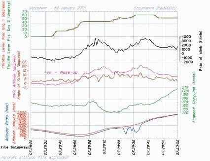
92 85


93 86

94 87
P474 SYDNEY AIRPORT WIND SHEAR ENCOUNTER - 15 APRIL 2007
 P474 SYDNEY AIRPORT WIND SHEAR ENCOUNTER - 15 APRIL 2007 Rodney Potts* 1, Barry Hanstrum 2 and Peter Dunda 2 1. CAWCR, Bureau of Meteorology, Melbourne, VIC, Australia 2. Bureau of Meteorology, Sydney,
M o d u l e k A i r c r a f t A e r o d y n a m i c s, S t r u c t u r e s a n d S y s t e m s
 Category A B1 B2 B3 08 Instrument systems (ATA 31) Level 1 2 3 M o d u l e 1 3-0 8 k A i r c r a f t A e r o d y n a m i c s, S t r u c t u r e s a n d S y s t e m s I n s t r u m e n t S y s t e m s -
Section 7: Hazard Avoidance
 7.1 In-Flight Hazard Awareness Section 7: Hazard Avoidance As technology improves, pilots have more and more real-time information within reach in all phases of flight. Terrain proximity, real-time weather
Doppler Weather Radars and Weather Decision Support for DP Vessels
 Author s Name Name of the Paper Session DYNAMIC POSITIONING CONFERENCE October 14-15, 2014 RISK SESSION Doppler Weather Radars and By Michael D. Eilts and Mike Arellano Weather Decision Technologies, Inc.
SERIOUS INCIDENT. Aircraft Type and Registration: 2) Embraer EMB 121 Xingu F-TEZZ. Date & Time (UTC): 1 June 2010 at 1000 hrs.
 Embraer EMB 121 Xingu F-TEZZ. Date & Time (UTC): 1 June 2010 at 1000 hrs.") SERIOUS INCIDENT Aircraft Type and Registration: Date & Time (UTC): Location: Type of Flight: 1) Embraer ERJ 190-200 LR G-FBEE, 2) Embraer EMB 121 Xingu F-TEZZ 1 June 2010 at 1000 hrs Jersey Airport, Channel
SERIOUS INCIDENT Aircraft Type and Registration: Date & Time (UTC): Location: Type of Flight: 1) Embraer ERJ 190-200 LR G-FBEE, 2) Embraer EMB 121 Xingu F-TEZZ 1 June 2010 at 1000 hrs Jersey Airport, Channel
METEOROLOGY PANEL (METP) WORKING GROUP- METEOROLOGICAL OPERATION GROUP (MOG) FIRST MEETING
 WORKING GROUP- METEOROLOGICAL OPERATION GROUP (MOG) FIRST MEETING") 8 28/7/15 METEOROLOGY PANEL (METP) WORKING GROUP- METEOROLOGICAL OPERATION GROUP (MOG) FIRST MEETING Gatwick, United Kingdom, 08 to 11 September 2015 Agenda Item 3: Matters relating to SADIS 3.3: Operations
8 28/7/15 METEOROLOGY PANEL (METP) WORKING GROUP- METEOROLOGICAL OPERATION GROUP (MOG) FIRST MEETING Gatwick, United Kingdom, 08 to 11 September 2015 Agenda Item 3: Matters relating to SADIS 3.3: Operations
AVIATION INVESTIGATION REPORT A04A0057 WING SCRAPE DURING A REJECTED LANDING
 AVIATION INVESTIGATION REPORT A04A0057 WING SCRAPE DURING A REJECTED LANDING CARGOJET AIRWAYS LIMITED BOEING 727-225 C-GCJB GREATER MONCTON INTERNATIONAL AIRPORT MONCTON, NEW BRUNSWICK 28 MAY 2004 The
Traffic and Weather. Soaring Safety Foundation. Tom Johnson CFIG
 Traffic and Weather Soaring Safety Foundation Tom Johnson CFIG Weather Contents Weather Gathering Sources Weather Acquisition Enroute Weather Analysis Weather Hazards Weather in the Landing Pattern Basic
ADL110B ADL120 ADL130 ADL140 How to use radar and strike images. Version
 ADL110B ADL120 ADL130 ADL140 How to use radar and strike images Version 1.00 22.08.2016 How to use radar and strike images 1 / 12 Revision 1.00-22.08.2016 WARNING: Like any information of the ADL in flight
AERODROME METEOROLOGICAL OBSERVATION AND FORECAST STUDY GROUP (AMOFSG)
") AMOFSG/9-SN No. 15 21/6/11 AERODROME METEOROLOGICAL OBSERVATION AND FORECAST STUDY GROUP (AMOFSG) NINTH MEETING Montréal, 26 to 30 September 2011 Agenda Item 5: Observing and forecasting at the aerodrome
AMOFSG/9-SN No. 15 21/6/11 AERODROME METEOROLOGICAL OBSERVATION AND FORECAST STUDY GROUP (AMOFSG) NINTH MEETING Montréal, 26 to 30 September 2011 Agenda Item 5: Observing and forecasting at the aerodrome
Accident Prevention Program
 Thunderstorm Accident Prevention Program Thunderstorms - Don't Flirt...Skirt'Em Pilot's Beware! Within the route you intend to fly may lie a summer hazard in wait for the unwary--the Thunderstorm. The
Flight Operations Briefing Notes
 Flight Operations Briefing Notes I Introduction Flight crew awareness and alertness are key factors in the successful application of windshear avoidance and escape / recovery techniques. This Flight Operations
MET Lecture 34 Downbursts
 MET 4300 Lecture 34 Downbursts Downbursts A strong downdraft that originates within the lower part of a cumulus cloud or thunderstorms and spreads out at the surface Downbursts do not require strong thunderstorms
Real-Time defenses. FlightOPS
 Real-Time defenses By Wayne Rosenkrans Integrating data from terminal Doppler weather radar and anemometer-based wind shear alerting systems during the past years has further reduced, but not eliminated,
Information Note on the Webpage for Significant Convection Monitoring and Forecast
 Information Note on the Webpage for Significant Convection Monitoring and Forecast The webpage displays both the real-time products for monitoring of significant convection and forecast products for significant
Published by the Hong Kong Observatory, Hong Kong Special Administrative Region Government.
 Windshear and Turbulence in Hong Kong - information for pilots Published by the Hong Kong Observatory, Hong Kong Special Administrative Region Government. 1st edition 2002 2nd edition 2005 Copyright reserved
International Civil Aviation Organization
 CNS/MET SG/14 IP/19 International Civil Aviation Organization FOURTEENTH MEETING OF THE COMMUNICATIONS/NAVIGATION/SURVEILL ANCE AND METEOROLOGY SUB-GROUP OF APANPIRG (CNS/MET SG/14) Jakarta, Indonesia,
SAMPLE ASSESSMENT TASKS AVIATION ATAR YEAR 12
 SAMPLE ASSESSMENT TASKS AVIATION ATAR YEAR 12 Copyright School Curriculum and Standards Authority, 2015 This document apart from any third party copyright material contained in it may be freely copied,
Automated Thunderstorm Alert Service (ATSAS) User Guide
 User Guide") Automated Thunderstorm Alert Service (ATSAS) User Guide November 2016 Table of Contents 1 ATSAS System...2 1.1.1 Background Map... 3 1.1.2 Thunderstorm Cell and Trac k... 3 1.1.3 Legend... 4 1.1.4 ATSAS
Automated Thunderstorm Alert Service (ATSAS) User Guide November 2016 Table of Contents 1 ATSAS System...2 1.1.1 Background Map... 3 1.1.2 Thunderstorm Cell and Trac k... 3 1.1.3 Legend... 4 1.1.4 ATSAS
Aviation Hazards: Thunderstorms and Deep Convection
 Aviation Hazards: Thunderstorms and Deep Convection TREND Diagnosis of thunderstorm hazards using imagery Contents Satellite imagery Visible, infrared, water vapour Basic cloud identification Identifying
Pilot briefing ENTC - Tromsø airport, Langnes
 Pilot briefing ENTC - Tromsø airport, Langnes NOTE: The content in this briefing will not be updated as frequently as AIP Norway. Make sure you always check relevant information in the latest edition of
Montréal, 7 to 18 July 2014
 INTERNATIONAL CIVIL AVIATION ORGANIZATION WORLD METEOROLOGICAL ORGANIZATION MET/14-WP/34 28/5/14 Meteorology (MET) Divisional Meeting (2014) Commission for Aeronautical Meteorology Fifteenth Session Montréal,
ATM Network Performance Report
 ATM Network Performance Report 2019 Page 1 of 18 Table of contents Summary... 3 Network Wide Performance... 4 Airborne delay... 4 Sydney... 7 Airborne delay... 7 Notable events... 7 Melbourne... 9 Airborne
Use of radar to detect weather
 2 April 2007 Welcome to the RAP Advisory Panel Meeting Use of radar to detect weather G. Brant Foote Brant Director Foote Rita Roberts Roelof Bruintjes Research Applications Program Radar principles Radio
Use of lightning data to improve observations for aeronautical activities
 Use of lightning data to improve observations for aeronautical activities Françoise Honoré Jean-Marc Yvagnes Patrick Thomas Météo_France Toulouse France I Introduction Aeronautical activities are very
MINISTRY OF DEFENCE MILITARY AIRCRAFT ACCIDENT SUMMARY
 MINISTRY OF DEFENCE MILITARY AIRCRAFT ACCIDENT SUMMARY AIRCRAFT ACCIDENT TO ROYAL AIR FORCE TORNADO F3 ZG751 AIRCRAFT: RAF Tornado F3 ZG751 DATE: 25 August 2003 LOCATION: PARENT UNIT: CREW: INJURIES: CFB
Deriving Meteorological Data from free-to-air Mode-S broadcasts in an Australian Context.
 Deriving Meteorological Data from free-to-air Mode-S broadcasts in an Australian Context. Douglas Body Bureau of Meteorology, Melbourne, Australia d.body@bom.gov.au ABSTRACT Using free to air Automatic
NJ SURVEYORS CONFERENCE
 NJ SURVEYORS CONFERENCE PART 107 Ground School TODAY S AGENDA Regulations National Airspace System Operations Weather Loading and Performance 1 REGULATIONS Remote Pilot Certifications and Privileges When
Guidance to Instructors on Subject Delivery PILOT NAVIGATION. This is a suggested programme for the delivery of this subject.
 Programme of learning: Guidance to Instructors on Subject Delivery This is a suggested programme for the delivery of this subject. The main headings are the Learning Outcomes (LO1, LO2, etc), with sub
Transparency: Redoubt ash cloud
 Module 1 Investigation 3 Transparency: Redoubt ash cloud Aerial view of Redoubt Volcano during a continuous, low-level eruption of steam and ash December 18, 1989 Source: photo by W. White, USGS, http://www.avo.alaska.edu/avo3/volc/redou/photo.htm
Guidance on Aeronautical Meteorological Observer Competency Standards
 Guidance on Aeronautical Meteorological Observer Competency Standards The following guidance is supplementary to the AMP competency Standards endorsed by Cg-16 in Geneva in May 2011. Format of the Descriptions
Effective: SPECI ALERTING
 AUSTRALIA AERONAUTICAL INFORMATION SERVICE AIRSERVICES AUSTRALIA GPO BOX 367, CANBERRA ACT 2601 Phone: 02 6268 4874 Email: aim.editorial@airservicesaustralia.com Effective: AERONAUTICAL INFORMATION CIRCULAR
THUNDERSTORMS-RISK FACTORS IN AVIATION. CASE STUDY: AREA OF RESPONSABILITY OF THE BUCHAREST- OTOPENI AERODROME ON
 RISCURI ŞI CATASTROFE, NR. XIV, VOL. 17, NR.2/2015 THUNDERSTORMS-RISK FACTORS IN AVIATION. CASE STUDY: AREA OF RESPONSABILITY OF THE BUCHAREST- OTOPENI AERODROME ON 30.06.2009 C. L. ŞCHIOPU 1, NICOLETA
SUMMARY. information from
 INTERNATIONAL CIVIL AVIATION ORGANIZATION WORLD METEOROLOGICAL ORGANIZATION MET/14-IP/ /16 2/6/14 English only Meteorology (MET) Divisional Meeting (2014) Commission for Aeronautical Meteorology Fifteenth
Airbus A320 registered TS-IMC Date and time 12 March 2013 at 10 h 15 UTC (1) Operator
 Operator") www.bea.aero REPORT INCIDENT Runway overrun during taxiing after landing (1) Except where otherwise stated, the times shown in this report are expressed in Universal Time Coordinated (UTC). Aircraft Airbus
www.bea.aero REPORT INCIDENT Runway overrun during taxiing after landing (1) Except where otherwise stated, the times shown in this report are expressed in Universal Time Coordinated (UTC). Aircraft Airbus
Reprint 797. Development of a Thunderstorm. P.W. Li
 Reprint 797 Development of a Thunderstorm Nowcasting System in Support of Air Traffic Management P.W. Li AMS Aviation, Range, Aerospace Meteorology Special Symposium on Weather-Air Traffic Management Integration,
Aerodrome Forecast (TAF)
") AVIATION WEATHER PRODUCTS () Bureau of Meteorology Aviation Weather Services A is a coded statement of meteorological conditions expected at an and within a radius of five nautical miles of the reference
AVIATION WEATHER PRODUCTS () Bureau of Meteorology Aviation Weather Services A is a coded statement of meteorological conditions expected at an and within a radius of five nautical miles of the reference
Montréal, 7 to 18 July 2014
 INTERNATIONAL CIVIL AVIATION ORGANIZATION WORLD METEOROLOGICAL ORGANIZATION 6/5/14 Meteorology (MET) Divisional Meeting (2014) Commission for Aeronautical Meteorology Fifteenth Session Montréal, 7 to 18
THUNDERSTORM OCCURENCE AND ASSOCIATED FLIGHT HAZARDS IN THE SOUTHERN PART OF ROMANIA
 SCIENTIFIC RESEARCH AND EDUCATION IN THE AIR FORCE-AFASES 2016 THUNDERSTORM OCCURENCE AND ASSOCIATED FLIGHT HAZARDS IN THE SOUTHERN PART OF ROMANIA Carmen STEFAN Romanian Aviation Academy, Bucharest, Romania
Weather Technology in the Cockpit (WTIC) Shortfall Analysis of Weather Information in Remote Airspace Friends and Partners of Aviation Weather Summer
 Shortfall Analysis of Weather Information in Remote Airspace Friends and Partners of Aviation Weather Summer") Weather Technology in the Cockpit (WTIC) Shortfall Analysis of Weather Information in Remote Airspace Friends and Partners of Aviation Weather Summer Meeting Tim Myers Metron Aviation August 26, 2015 2
Weather Technology in the Cockpit (WTIC) Shortfall Analysis of Weather Information in Remote Airspace Friends and Partners of Aviation Weather Summer Meeting Tim Myers Metron Aviation August 26, 2015 2
Mechanical Turbulence Wind forms eddies as it blows around hanger, stands of trees or other obstructions
 Turbulence Low-level Turbulence below 15,000 feet consists of Mechanical Turbulence Convective Turbulence Frontal Turbulence Wake Turbulence Mechanical Turbulence Wind forms eddies as it blows around hanger,
Encounter with damaging hail, Boeing , TF-ARD
 Encounter with damaging hail, Boeing 757-225, TF-ARD Micro-summary: This Boeing 757-225 had a damaging encounter with hail in flight. Event Date: 2005-08-20 at 1210 UTC Investigative Body: Aircraft Accident
Hong Kong Collection
 (Disclaimer The Government of the Hong Kong Special Administrative Region (including its servants and agents) and the International Federation of Air Line Pilots' Associations make no warranty, statement
WAFS_Word. 2. Menu. 2.1 Untitled Slide
 WAFS_Word 2. Menu 2.1 Untitled Slide Published by Articulate Storyline 1. Introduction 1.1 Introduction Notes: As you will probably be aware, the traditional significant weather forecasts, usually seen
AERODROME METEOROLOGICAL OBSERVATION AND FORECAST STUDY GROUP (AMOFSG)
") AMOFSG/9-SN No. 32 22/8/11 AERODROME METEOROLOGICAL OBSERVATION AND FORECAST STUDY GROUP (AMOFSG) NINTH MEETING Montréal, 26 to 30 September 2011 Agenda Item 5: Observing and forecasting at the aerodrome
AMOFSG/9-SN No. 32 22/8/11 AERODROME METEOROLOGICAL OBSERVATION AND FORECAST STUDY GROUP (AMOFSG) NINTH MEETING Montréal, 26 to 30 September 2011 Agenda Item 5: Observing and forecasting at the aerodrome
AERODROME METEOROLOGICAL OBSERVATION AND FORECAST STUDY GROUP (AMOFSG)
") AMOFSG/10-IP/4 21/5/13 AERODROME METEOROLOGICAL OBSERVATION AND FORECAST STUDY GROUP (AMOFSG) TENTH MEETING Montréal, 17 to 19 June 2013 Agenda Item 5: Aerodrome observations AUTOMATED CLOUD INFORMATION
AMOFSG/10-IP/4 21/5/13 AERODROME METEOROLOGICAL OBSERVATION AND FORECAST STUDY GROUP (AMOFSG) TENTH MEETING Montréal, 17 to 19 June 2013 Agenda Item 5: Aerodrome observations AUTOMATED CLOUD INFORMATION
METEOROLOGY. 1 The average height of the tropopause at 50 N is about A 14 km B 16 km C 11 km D 8 km
 1 The average height of the tropopause at 50 N is about A 14 km B 16 km C 11 km D 8 km 2 In the lower part of the stratosphere the temperature A is almost constant B decreases with altitude C increases
CAIRNS AIRPORT CYCLONE PLAN
 CAIRNS AIRPORT CYCLONE PLAN Reference No: 2046 SO Version 5 25 th October 2017 2046_SO_CairnsAirportCyclonePlan_V5_Effectivedate_25/10/2017_Reviewdate_25/10/2018 Page 1 of 10 Document Control Reference
UNITED KINGDOM AERONAUTICAL INFORMATION CIRCULAR
 N UNITED KINGDOM AERONAUTICAL INFORMATION CIRCULAR AIC 84/2008 (Pink 150) 11 September Safety NATS Ltd UK Aeronautical Information Service Heathrow House Bath Road Hounslow Middlesex TW5 9AT Editorial:
The Ice Crystal Weather Threat to Engines
 Jeanne Mason Boeing Commercial Airplanes The Ice Crystal Weather Threat to Engines BOEING is a trademark of Boeing Management Company. Filename.ppt 1 Agenda Introduction Recognition of engine power-loss
Science Olympiad Meteorology Quiz #2 Page 1 of 8
 1) The prevailing general direction of the jet stream is from west to east in the northern hemisphere: 2) Advection is the vertical movement of an air mass from one location to another: 3) Thunderstorms
QNH: With this setting set on your altimeter you will be reading altitude above mean sea level based on the local station pressure.
 ALTIMETRY How many different altimeter settings confront you when operating internationally? Not only that, how many different ways are there to report an altimeter setting? If not operating internationally
Recap of the NTSB PIREP Forum: Optimizing Safety Benefits for Pilots, ATC, and Meteorologists. Paul Suffern NTSB Meteorologist
 Recap of the NTSB PIREP Forum: Optimizing Safety Benefits for Pilots, ATC, and Meteorologists Paul Suffern NTSB Meteorologist 1 2 Wx Accident Trend 3 Preflight Planning TAF KRDU 162340Z 1700/1724 28003KT
CAIRNS AIRPORT CYCLONE PLAN
 CAIRNS AIRPORT CYCLONE PLAN Reference No: 2046 SO Version 5.1 6 th February 2018 2046_SO_CairnsCyclonePlan_V5.1_Effectivedate_06/02/2018_Reviewdate_06/02/2019 Page 1 of 10 Document Control Reference No
P13A.4 THE AIR FRANCE 358 INCIDENT OF 2 AUGUST 2005 AT TORONTO INTERNATIONAL AIRPORT. Paul Joe
 P13A.4 THE AIR FRANCE 358 INCIDENT OF 2 AUGUST 2005 AT TORONTO INTERNATIONAL AIRPORT Paul Joe Environment Canada, 4905 Dufferin St., Toronto, Ontario, CANADA M3H 5T4 email: paul.joe@ec.gc.ca tel: 416 739
SCOPE: Outlines standard techniques for setting up and conducting voice communication and broadcasting ATIS at Hong Kong VACC
 STANDARD OPERATING PROCEDURE (SOP) DOCUMENT NUMBER: HKVACC-SOP011-R5 DATE ISSUED: 1 APR 2015 REVISION: 5 SUBJECT: Voice Communication Setup and ATIS Guide EFFECTIVE DATE: 5 AUG 2018 SCOPE: Outlines standard
Also published by the Board of Trade, United Kingdom as C.A.P. 268
 Extracted from ICAO Circular 88-AN/74, pp 142-149. 2014 PicMA site editor's note: this flight was initially conducted under BEA's policy to use PicMA procedures. However the Captain elected to abandon
SCOPE: Outlines standard techniques for setting up and conducting voice communication and broadcasting ATIS at Hong Kong VACC
 STANDARD OPERATING PROCEDURE (SOP) DOCUMENT NUMBER: HKVACC-SOP011-R5 DATE ISSUED: 1 APR 2015 REVISION: 5 SUBJECT: Voice Communication Setup and ATIS Guide EFFECTIVE DATE: 5 AUG 2018 SCOPE: Outlines standard
TOPICS: What are Thunderstorms? Ingredients Stages Types Lightning Downburst and Microburst
 THUNDERSTORMS TOPICS: What are Thunderstorms? Ingredients Stages Types Lightning Downburst and Microburst What are Thunderstorms? A storm produced by a cumulonimbus cloud that contains lightning and thunder
GEN 3.5 METEOROLOGICAL SERVICES
 AIP GEN 3.5-1 GEN 3.5 METEOROLOGICAL SERVICES 1. RESPONSIBLE SERVICE The meteorological services for civil aviation at Jordan are provided by the Jordanian Meteorological Department. Postal Address: Director
QLD-S NSW-E NSW-W VIC TAS. A HEADER giving details of the time of issue and the associated validity period.
 FLIGHT FORECASTS Flight Forecasts are issued on request for flights for which GAFs are not available. They are subject to the requirements of AIP GEN 3.5 para 3.1 and AIP GEN 3.5 para 10.3. Flight forecasts
P1.1 THE NATIONAL AVIATION WEATHER PROGRAM: AN UPDATE ON IMPLEMENTATION
 P1.1 THE NATIONAL AVIATION WEATHER PROGRAM: AN UPDATE ON IMPLEMENTATION Thomas S. Fraim* 1, Mary M. Cairns 1, and Anthony R. Ramirez 2 1 NOAA/OFCM, Silver Spring, MD 2 Science and Technology Corporation,
The Montague Doppler Radar, An Overview
 ISSUE PAPER SERIES The Montague Doppler Radar, An Overview June 2018 NEW YORK STATE TUG HILL COMMISSION DULLES STATE OFFICE BUILDING 317 WASHINGTON STREET WATERTOWN, NY 13601 (315) 785-2380 WWW.TUGHILL.ORG
Meteorology. Review Extreme Weather a. cold front. b. warm front. What type of weather is associated with a:
 Meteorology 5.08 Extreme Weather References: FTGU pages 132, 144, 145, 148-155 Air Command Weather Manual Chapters 9 and 15 Review What type of weather is associated with a: a. cold front b. warm front
MSG FOR NOWCASTING - EXPERIENCES OVER SOUTHERN AFRICA
 MSG FOR NOWCASTING - EXPERIENCES OVER SOUTHERN AFRICA Estelle de Coning and Marianne König South African Weather Service, Private Bag X097, Pretoria 0001, South Africa EUMETSAT, Am Kavalleriesand 31, D-64295
Metar And Taf Decoding
 Metar And Taf Decoding 1 / 6 2 / 6 3 / 6 Metar And Taf Decoding examples: kmem 230853z auto 18014g18kt 10sm clr 16/m02 a3008 rmk ao2 slp117 t01561022 tsno $ klax 161550z cor 11004kt 2 1/2sm hz bkn011 bkn015
International Civil Aviation Organization THIRD MEETING OF THE METEOROLOGICAL REQUIREMENTS TASK FORCE (MET/R TF/3)
") MET/R TF/3 IP/02 International Civil Aviation Organization THIRD MEETING OF THE METEOROLOGICAL REQUIREMENTS TASK FORCE (MET/R TF/3) 28 29 November 2013, Bangkok, Thailand Agenda Item 3a: Current and future
MET/R TF/3 IP/02 International Civil Aviation Organization THIRD MEETING OF THE METEOROLOGICAL REQUIREMENTS TASK FORCE (MET/R TF/3) 28 29 November 2013, Bangkok, Thailand Agenda Item 3a: Current and future
GRAPHICAL AREA FORECASTS (GAF) feet. Flight Information Region boundary QLD-S NSW-E VIC TAS
 feet. Flight Information Region boundary QLD-S NSW-E VIC TAS") GRAPHICAL AREA FORECASTS (GAF) Unlike at TAF, a Graphical Area Forecasts (GAFs) does not describe conditions expected at a particular location, it refers to a defined area and is intended for use in planning
GRAPHICAL AREA FORECASTS (GAF) Unlike at TAF, a Graphical Area Forecasts (GAFs) does not describe conditions expected at a particular location, it refers to a defined area and is intended for use in planning
TRAFFIC,TRAFFIC - 5 O CLOCK LOW - 2 MILES
 SPOT THE PROBLEM. For more than a decade, pilots have trusted SkyWatch Collision Avoidance Systems to enhance safety by helping them spot traffic. SkyWatch was the first Active Collision Avoidance System
Weather Related Factors of the Adelaide floods ; 7 th to 8 th November 2005
 Weather Related Factors of the Adelaide floods ; th to th November 2005 Extended Abstract Andrew Watson Regional Director Bureau of Meteorology, South Australian Region 1. Antecedent Weather 1.1 Rainfall
Aircraft Operation Anomaly Detection Using FDR Data
 Aircraft Operation Anomaly Detection Using FDR Data Lishuai Li, Maxime Gariel, R. John Hansman IAB/Airline Industry Consortium Nov 4, 2010 1 Motivation Commercial aircraft accident rate has dropped significantly.
Preventing Runway Excursions. Landing on wet / Contaminated Runways
 Preventing Runway Excursions Landing on wet / Contaminated Runways Overview Introduction Definition Runway Condition Runway Condition Reporting Pilot Operational Aspects Landing Performance Airport Operational
Gleim Private Pilot FAA Knowledge Test 2015 Edition, 1st Printing Updates July 2015
 Page 1 of 6 Gleim Private Pilot FAA Knowledge Test 2015 Edition, 1st Printing Updates July 2015 NOTE: Deleted text is displayed with a line through it. New text is shown with a blue background. If you
Preventing Runway Excursions. Landing on wet / Contaminated Runways
 Preventing Runway Excursions Landing on wet / Contaminated Runways Overview Introduction Definition Runway Condition Runway Condition Reporting Pilot Operational Aspects Landing Performance Airport Operational
SEYCHELLES TECHNICAL STANDARDS
 SEYCHELLES TECHNICAL STANDARDS Aviation Meteorological Standards Seychelles Technical Standards Aviation Meteorological Standards Issue 01 July 2017 CONTENTS (general layout) FOREWORD Aviation Meteorological
Foundations of Earth Science, 6e Lutgens, Tarbuck, & Tasa
 Foundations of Earth Science, 6e Lutgens, Tarbuck, & Tasa Weather Patterns and Severe Weather Foundations, 6e - Chapter 14 Stan Hatfield Southwestern Illinois College Air masses Characteristics Large body
Safety in Numbers SKYWATCH 497. The affordable original.
 SKYWATCH 497 Safety in Numbers The affordable original. For over 10 years, pilots have trusted SkyWatch Collision Avoidance Systems to help them fly safely. SkyWatch was the first Active Collision Avoidance
The current status, functions, challenges and needs of South Sudan Meteorological Department (SSMD)
") The current status, functions, challenges and needs of South Sudan Meteorological Department (SSMD) Presented: by Mojwok Ogawi Modo, South Sudan Meteorological Department. Background The present SSMD was
The current status, functions, challenges and needs of South Sudan Meteorological Department (SSMD) Presented: by Mojwok Ogawi Modo, South Sudan Meteorological Department. Background The present SSMD was
ANNEX 23 RESOLUTION MSC.231(82) ADOPTION OF AMENDMENTS TO THE EXISTING MANDATORY SHIP REPORTING SYSTEM IN THE GULF OF FINLAND
 ADOPTION OF AMENDMENTS TO THE EXISTING MANDATORY SHIP REPORTING SYSTEM IN THE GULF OF FINLAND") RESOLUTION MSC.231(82) (adopted on 5 December 2006) ADOPTION OF AMENDMENTS TO THE EXISTING MANDATORY SHIP REPORTING SYSTEM IN THE GULF OF FINLAND THE MARITIME SAFETY COMMITTEE, RECALLING Article 28(b)
RESOLUTION MSC.231(82) (adopted on 5 December 2006) ADOPTION OF AMENDMENTS TO THE EXISTING MANDATORY SHIP REPORTING SYSTEM IN THE GULF OF FINLAND THE MARITIME SAFETY COMMITTEE, RECALLING Article 28(b)
Federal Aviation Administration
 High Ice Water Content Research International Collaboration and Field Campaign Presented to: FPAW By: Tom Bond Date: Statement of Need Over the past 10+ years, it has been recognized that jet engine powerloss
MK V and MK VII Enhanced Ground Proximity Warning System Pilot's Guide Rev. D - March 2000 MK V & MK VII EGPWS Pilot Guide 1
 MK V and MK VII Enhanced Ground Proximity Warning System Pilot's Guide MK V & MK VII EGPWS Pilot Guide 1 This document is an unpublished work Copyright 2001 Honeywell International Inc. All rights reserved
Regional Hazardous Weather Advisory Centres (RHWACs)
") Regional Hazardous Weather Advisory Centres (RHWACs) The following outlines the criteria for the selection of RHWACs based on operational and functional requirements 1. Basic Principles The RHWAC must:
Regional Hazardous Weather Advisory Centres (RHWACs) The following outlines the criteria for the selection of RHWACs based on operational and functional requirements 1. Basic Principles The RHWAC must:
NINTH MEETING DISPLAY IN ATS UNITS. (Presented SUMMARY
 AMOFSG/9-SN No. 26 12/8/11 AERODROME METEOROLOGICAL OBSERVATION AND FORECAST STUDY GROUP (AMOFSG) NINTH MEETING Montréal, 26 to 30 September 2011 Agenda Item 6: MET informationn to support ATM UPDATING
Three-Dimensional Aerial Zoning around a Lebanese Airport
 Three-Dimensional Aerial Zoning around a Lebanese Airport Abstract by Oussama C. Jadayel and Rita Y. Ibrahim GIS Center, Faculty of Engineering, University of Balamand, P.O. Box: 100, Tripoli, LEBANON
Meteorological CLEAR BUT PRESENT DANGER
 THE INTERNATIONAL REVIEW OF WEATHER, CLIMATE, AND HYDROLOGY TECHNOLOGIES AND SERVICES Meteorological AUGUST 2012 T E C H N O L O G Y I N T E R N A T I O N A L CLEAR BUT PRESENT DANGER The latest Earth
Unique Vaisala Global Lightning Dataset GLD360 TM
 Unique Vaisala Global Lightning Dataset GLD360 TM / THE ONLY LIGHTNING DETECTION NETWORK CAPABLE OF DELIVERING SUCH HIGH-QUALITY DATA ANYWHERE IN THE WORLD GLD360 provides high-quality lightning data anywhere
the issue of for Aviation
 2/3/12 INTERNATIONAL VOLCANIC ASH TASK FORCE (IVATF) SECOND MEETING Montréal, 11 to 15 July 2011 List of Recommendations The second meeting of the International Volcanic Ash Task Force (IVATF/2), held
Deutscher Wetterdienst
 WakeNet3-Greenwake Workshop Wake Vortex & Wind Monitoring Sensors in all weather conditions DWD s new Remote Wind Sensing Equipment for an Integrated Terminal Weather System (ITWS) Frank Lehrnickel Project
and SUMMARY preliminary parameters. 1.1 MET/14-IP/ /15 In line 1.2 WORLD INTERNATIONAL CIVIL AVIATION ORGANIZATION 2/6/14 English only
 INTERNATIONAL CIVIL AVIATION ORGANIZATION Meteorology (MET) Divisional Meeting (2014) WORLD METEOROLOGICAL ORGANIZATION Commission for Aeronautical Meteorology Fifteenth Session MET/14-IP/ /15 2/6/14 English
Civil Aviation Authority of Nepal
 Civil Aviation Requirements For Meteorological Service for International Air Navigation CAR 3 First Edition - July, 2017 Civil Aviation Authority of Nepal Amendments Amendments and Corrigenda to these
CAP 437 Offshore Meteorological Observer Training
 CAP 437 Offshore Meteorological Observer Training Training for Meteorological Observers in support of Offshore Helicopter Operations CAP 437 Offshore Meteorological Observer Training Page 1 Meteorological
National Transportation Safety Board Office of Aviation Safety Washington, D.C December 10, 2012 WEATHER STUDY DCA13RA025
 A. ACCIDENT National Transportation Safety Board Office of Aviation Safety Washington, D.C. 20594-2000 December 10, 2012 WEATHER STUDY DCA13RA025 Location: Monterrey, Mexico Date: December 9, 2012 Time:
Lightning Safety in a Flash / VAISALA AIRPORT LIGHTNING INFORMATION SYSTEM (ALIS)
") Lightning Safety in a Flash / VAISALA AIRPORT LIGHTNING INFORMATION SYSTEM (ALIS) Global Threat to Airports Proven. Global. The Vaisala Airport Lightning Information System (ALIS) opens a new era of universal
Lightning Safety in a Flash / VAISALA AIRPORT LIGHTNING INFORMATION SYSTEM (ALIS) Global Threat to Airports Proven. Global. The Vaisala Airport Lightning Information System (ALIS) opens a new era of universal
10. Severe Local Storms (Thunderstorms)
") 10. Severe Local Storms (Thunderstorms) Hail. Can be larger than softball (10 cm in diameter) Smaller damage ratios, but over large areas In USA causes more than $1 billion crop and property damage each
10. Severe Local Storms (Thunderstorms) Hail. Can be larger than softball (10 cm in diameter) Smaller damage ratios, but over large areas In USA causes more than $1 billion crop and property damage each
Plan for operational nowcasting system implementation in Pulkovo airport (St. Petersburg, Russia)
") Plan for operational nowcasting system implementation in Pulkovo airport (St. Petersburg, Russia) Pulkovo airport (St. Petersburg, Russia) is one of the biggest airports in the Russian Federation (150
Plan for operational nowcasting system implementation in Pulkovo airport (St. Petersburg, Russia) Pulkovo airport (St. Petersburg, Russia) is one of the biggest airports in the Russian Federation (150
TERMS OF REFERENCE Special Committee (SC) 230 Airborne Weather Detection Systems Revision 5
 230 Airborne Weather Detection Systems Revision 5") TERMS OF REFERENCE Special Committee (SC) 230 Airborne Weather Detection Systems Revision 5 REQUESTORS: Organization FAA Associate Administrator for Aviation Safety Person Ms. Peggy Gilligan SC LEADERSHIP:
TERMS OF REFERENCE Special Committee (SC) 230 Airborne Weather Detection Systems Revision 5 REQUESTORS: Organization FAA Associate Administrator for Aviation Safety Person Ms. Peggy Gilligan SC LEADERSHIP:
SkyScan EWS-PRO - Manual -
 INTRODUCTION SkyScan EWS-PRO - Manual - EWS-Pro gives you advance weather warning technology you can use at home, indoors or out, and take wherever you go, for any kind of outdoor activity. Your EWS-Pro
AOPA. Mitigating Turbulence Impacts in Aviation Operations. General Aviation Perspective
 AOPA Mitigating Turbulence Impacts in Aviation Operations General Aviation Perspective Rune Duke Senior Director, Airspace & Air Traffic Services Aircraft Owners & Pilots Association AOPA Air Safety Institute
Module 11: Meteorology Topic 6 Content: Severe Weather Notes
 Severe weather can pose a risk to you and your property. Meteorologists monitor extreme weather to inform the public about dangerous atmospheric conditions. Thunderstorms, hurricanes, and tornadoes are
COLLINS WXR-2100 MULTISCAN RADAR FULLY AUTOMATIC WEATHER RADAR. Presented by: Rockwell Collins Cedar Rapids, Iowa 52498
 COLLINS WXR-2100 MULTISCAN RADAR FULLY AUTOMATIC WEATHER RADAR Presented by: Rockwell Collins Cedar Rapids, Iowa 52498 TABLE OF CONTENTS MultiScan Overview....................................................................................1